EP3851799A2 - Determine traffic checkpoint method and apparatus, electronic device, and medium - Google Patents
Determine traffic checkpoint method and apparatus, electronic device, and medium Download PDFInfo
- Publication number
- EP3851799A2 EP3851799A2 EP21164332.5A EP21164332A EP3851799A2 EP 3851799 A2 EP3851799 A2 EP 3851799A2 EP 21164332 A EP21164332 A EP 21164332A EP 3851799 A2 EP3851799 A2 EP 3851799A2
- Authority
- EP
- European Patent Office
- Prior art keywords
- points
- group
- coordinates
- intersection points
- boundary
- Prior art date
- Legal status (The legal status is an assumption and is not a legal conclusion. Google has not performed a legal analysis and makes no representation as to the accuracy of the status listed.)
- Granted
Links
- 238000000034 method Methods 0.000 title claims abstract description 44
- 238000004590 computer program Methods 0.000 claims description 12
- 230000004044 response Effects 0.000 claims description 3
- 230000015654 memory Effects 0.000 description 14
- 238000010586 diagram Methods 0.000 description 8
- 238000005516 engineering process Methods 0.000 description 8
- 238000004891 communication Methods 0.000 description 4
- 230000006870 function Effects 0.000 description 3
- 238000012545 processing Methods 0.000 description 3
- 230000002708 enhancing effect Effects 0.000 description 2
- 230000003993 interaction Effects 0.000 description 2
- 239000004973 liquid crystal related substance Substances 0.000 description 2
- 238000012986 modification Methods 0.000 description 2
- 230000004048 modification Effects 0.000 description 2
- 230000008569 process Effects 0.000 description 2
- 238000013473 artificial intelligence Methods 0.000 description 1
- 230000001413 cellular effect Effects 0.000 description 1
- 230000008859 change Effects 0.000 description 1
- 238000013500 data storage Methods 0.000 description 1
- 238000013461 design Methods 0.000 description 1
- 238000011161 development Methods 0.000 description 1
- 238000010295 mobile communication Methods 0.000 description 1
- 230000003287 optical effect Effects 0.000 description 1
- 230000001953 sensory effect Effects 0.000 description 1
- 230000000007 visual effect Effects 0.000 description 1
Images


Classifications
-
- G—PHYSICS
- G01—MEASURING; TESTING
- G01C—MEASURING DISTANCES, LEVELS OR BEARINGS; SURVEYING; NAVIGATION; GYROSCOPIC INSTRUMENTS; PHOTOGRAMMETRY OR VIDEOGRAMMETRY
- G01C21/00—Navigation; Navigational instruments not provided for in groups G01C1/00 - G01C19/00
- G01C21/26—Navigation; Navigational instruments not provided for in groups G01C1/00 - G01C19/00 specially adapted for navigation in a road network
- G01C21/34—Route searching; Route guidance
- G01C21/36—Input/output arrangements for on-board computers
- G01C21/3691—Retrieval, searching and output of information related to real-time traffic, weather, or environmental conditions
-
- G—PHYSICS
- G01—MEASURING; TESTING
- G01C—MEASURING DISTANCES, LEVELS OR BEARINGS; SURVEYING; NAVIGATION; GYROSCOPIC INSTRUMENTS; PHOTOGRAMMETRY OR VIDEOGRAMMETRY
- G01C21/00—Navigation; Navigational instruments not provided for in groups G01C1/00 - G01C19/00
- G01C21/26—Navigation; Navigational instruments not provided for in groups G01C1/00 - G01C19/00 specially adapted for navigation in a road network
- G01C21/28—Navigation; Navigational instruments not provided for in groups G01C1/00 - G01C19/00 specially adapted for navigation in a road network with correlation of data from several navigational instruments
- G01C21/30—Map- or contour-matching
- G01C21/32—Structuring or formatting of map data
-
- G—PHYSICS
- G01—MEASURING; TESTING
- G01C—MEASURING DISTANCES, LEVELS OR BEARINGS; SURVEYING; NAVIGATION; GYROSCOPIC INSTRUMENTS; PHOTOGRAMMETRY OR VIDEOGRAMMETRY
- G01C21/00—Navigation; Navigational instruments not provided for in groups G01C1/00 - G01C19/00
- G01C21/26—Navigation; Navigational instruments not provided for in groups G01C1/00 - G01C19/00 specially adapted for navigation in a road network
- G01C21/34—Route searching; Route guidance
- G01C21/3446—Details of route searching algorithms, e.g. Dijkstra, A*, arc-flags, using precalculated routes
-
- G—PHYSICS
- G01—MEASURING; TESTING
- G01C—MEASURING DISTANCES, LEVELS OR BEARINGS; SURVEYING; NAVIGATION; GYROSCOPIC INSTRUMENTS; PHOTOGRAMMETRY OR VIDEOGRAMMETRY
- G01C21/00—Navigation; Navigational instruments not provided for in groups G01C1/00 - G01C19/00
- G01C21/26—Navigation; Navigational instruments not provided for in groups G01C1/00 - G01C19/00 specially adapted for navigation in a road network
- G01C21/34—Route searching; Route guidance
- G01C21/3453—Special cost functions, i.e. other than distance or default speed limit of road segments
- G01C21/3461—Preferred or disfavoured areas, e.g. dangerous zones, toll or emission zones, intersections, manoeuvre types, segments such as motorways, toll roads, ferries
-
- G—PHYSICS
- G01—MEASURING; TESTING
- G01C—MEASURING DISTANCES, LEVELS OR BEARINGS; SURVEYING; NAVIGATION; GYROSCOPIC INSTRUMENTS; PHOTOGRAMMETRY OR VIDEOGRAMMETRY
- G01C21/00—Navigation; Navigational instruments not provided for in groups G01C1/00 - G01C19/00
- G01C21/38—Electronic maps specially adapted for navigation; Updating thereof
- G01C21/3804—Creation or updating of map data
- G01C21/3807—Creation or updating of map data characterised by the type of data
- G01C21/3811—Point data, e.g. Point of Interest [POI]
-
- G—PHYSICS
- G01—MEASURING; TESTING
- G01C—MEASURING DISTANCES, LEVELS OR BEARINGS; SURVEYING; NAVIGATION; GYROSCOPIC INSTRUMENTS; PHOTOGRAMMETRY OR VIDEOGRAMMETRY
- G01C21/00—Navigation; Navigational instruments not provided for in groups G01C1/00 - G01C19/00
- G01C21/38—Electronic maps specially adapted for navigation; Updating thereof
- G01C21/3804—Creation or updating of map data
- G01C21/3807—Creation or updating of map data characterised by the type of data
- G01C21/3815—Road data
-
- G—PHYSICS
- G01—MEASURING; TESTING
- G01C—MEASURING DISTANCES, LEVELS OR BEARINGS; SURVEYING; NAVIGATION; GYROSCOPIC INSTRUMENTS; PHOTOGRAMMETRY OR VIDEOGRAMMETRY
- G01C21/00—Navigation; Navigational instruments not provided for in groups G01C1/00 - G01C19/00
- G01C21/38—Electronic maps specially adapted for navigation; Updating thereof
- G01C21/3804—Creation or updating of map data
- G01C21/3833—Creation or updating of map data characterised by the source of data
- G01C21/3841—Data obtained from two or more sources, e.g. probe vehicles
-
- G—PHYSICS
- G01—MEASURING; TESTING
- G01C—MEASURING DISTANCES, LEVELS OR BEARINGS; SURVEYING; NAVIGATION; GYROSCOPIC INSTRUMENTS; PHOTOGRAMMETRY OR VIDEOGRAMMETRY
- G01C21/00—Navigation; Navigational instruments not provided for in groups G01C1/00 - G01C19/00
- G01C21/38—Electronic maps specially adapted for navigation; Updating thereof
- G01C21/3863—Structures of map data
-
- G—PHYSICS
- G06—COMPUTING; CALCULATING OR COUNTING
- G06Q—INFORMATION AND COMMUNICATION TECHNOLOGY [ICT] SPECIALLY ADAPTED FOR ADMINISTRATIVE, COMMERCIAL, FINANCIAL, MANAGERIAL OR SUPERVISORY PURPOSES; SYSTEMS OR METHODS SPECIALLY ADAPTED FOR ADMINISTRATIVE, COMMERCIAL, FINANCIAL, MANAGERIAL OR SUPERVISORY PURPOSES, NOT OTHERWISE PROVIDED FOR
- G06Q50/00—Information and communication technology [ICT] specially adapted for implementation of business processes of specific business sectors, e.g. utilities or tourism
- G06Q50/40—Business processes related to the transportation industry
Definitions
- the present disclosure relates to the field of computer technologies, and in particular to a method and apparatus for determining a traffic checkpoint, an electronic device, and a medium.
- Data of the customs port is often updated manually at regular intervals, for example, once a year.
- manually updating data may cause untimely or false update of the data of the customs port, and then cause poorly planned routes, detours, infeasible planning schemes, or other problems.
- a computer-implemented method for determining a traffic checkpoint comprising: acquiring data of vehicle trajectories within a predetermined area, the predetermined area being determined by a boundary between two adjacent areas; matching the data of the vehicle trajectories with map data within the predetermined area to obtain a matching road network; determining a plurality of intersection points between the road network and the boundary, and dividing the plurality of intersection points into at least one group, a distance between any two intersection points in a first group of the at least one group being less than a preset value; and determining a specific position of a first traffic checkpoint in the first group based on a number of the vehicle trajectories passing each of the intersection points in the first group of the at least one group.
- an apparatus for determining a traffic checkpoint comprising: an acquisition module configured to acquire data of vehicle trajectories within a predetermined area, the predetermined area being determined by a boundary between two adjacent areas; a matching module configured to match the data of the vehicle trajectories with map data within the predetermined area to obtain a matching road network; a determination module configured to determine a plurality of intersection points between the road network and the boundary, and divide the plurality of intersection points into at least one group, a distance between any two intersection points in a first group of the at least one group being less than a preset value; and a planning module configured to determine a specific position of a traffic checkpoint in the first group based on the number of vehicle trajectories passing each of the intersection point in the first group of the at least one group.
- a computer program product comprising program code portions for performing the method described in the present disclosure when the computer program product is executed on one or more computing devices.
- a computer-readable storage medium which has computer program instructions stored thereon, wherein the computer program instructions, when executed by a processor, cause the processor to perform the method described in the present disclosure.
- data of the customs port can be automatically updated and user navigation experience can be enhanced.
- FIG. 1 is a flowchart showing a method 100 for determining a traffic checkpoint according to an embodiment of the present disclosure.
- step 101 acquiring data of vehicle trajectories within a predetermined area, the predetermined area being determined by a boundary between two adjacent areas.
- step 102 matching the data of the vehicle trajectories with map data within the predetermined area to obtain a matching road network.
- step 103 determining a plurality of intersection points between the road network and the boundary, and dividing the plurality of intersection points into at least one group, a distance between any two intersection points in a first group of the at least one group being less than a preset value.
- step 104 determining a specific position of a first traffic checkpoint in the first group based on a number of the vehicle trajectories passing each of the intersection points in the first group of the at least one group.
- the method 100 for determining a traffic checkpoint makes it possible that a specific position of an opening traffic checkpoint can be determined by using the collected data of the vehicle trajectories that is more up-to-date, thereby avoiding untimely or false update of customs port (that is, traffic checkpoint) data that may be caused by manually updating data in the related technologies.
- the method 100 according to this embodiment makes it possible to obtain corresponding possible positions of a current traffic checkpoint without a need to manually update data, and select the most possible position therefrom as a position of the current traffic checkpoint.
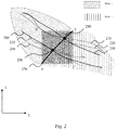
- FIG. 2 is a schematic diagram showing a relationship among vehicle trajectories, road networks, and administrative areas according to an embodiment of the present disclosure.
- an area 1 and an area 2 are different areas, the area 1 and the area 2 have a boundary 270, and the boundary 270 has an endpoint A and an endpoint B.
- vehicle trajectories comprising: a vehicle trajectory 210, a vehicle trajectory 220, a vehicle trajectory 240, and a vehicle trajectory 250.
- a road network 230 and a road network 260 are preset road networks on a map. There is an intersection point 280 between the road network 230 and the boundary 270, and there is an intersection point 290 between the road network 260 and the boundary 270.
- the predetermined area is determined by performing operations comprising: acquiring coordinates of a plurality of points on the boundary in a first direction and coordinates of the plurality of points in a second direction, the plurality of points being obtained from the boundary with predetermined precision; comparing the coordinates of the plurality of points in the first direction to obtain X max and X min , wherein X max is a maximum value among the coordinates of the plurality of points in the first direction, and X min is a minimum value among the coordinates of the plurality of points in the first direction; comparing the coordinates of the plurality of points in the second direction to obtain Y max and Y min , wherein Y max is a maximum value among the coordinates of the plurality of points in the second direction, and Y min is a minimum value among the coordinates of the plurality of points in the second direction, and determining coordinates of four vertices of the predetermined area as (X min , Y max ), (X max , Y max ), (X max ,
- acquiring X coordinates and Y coordinates of the plurality of points on the boundary 270 The plurality of points is obtained with predetermined precision, for example, the X coordinates and Y coordinates of the plurality of points on the boundary 270 are acquired with precision of 1 meter.
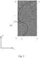
- FIG. 3 is a schematic diagram showing a relationship between a boundary and a predetermined area according to an embodiment of the present disclosure.
- the relationship between the shape of a boundary and a predetermined area is complex.
- the plurality of points is obtained with predetermined precision, for example, the X coordinates and Y coordinates of the plurality of points on the boundary 370 are acquired with precision of 1 meter.
- step 101 acquiring data of vehicle trajectories within a predetermined area, the predetermined area being determined by a boundary between two adjacent areas. It can be learned in conjunction with Figs 2 and 3 that, the predetermined area is determined by the boundary 270 or the boundary 370 between the two adjacent areas.
- the predetermined area is determined by the boundary, acquiring the data of the vehicle trajectories within the predetermined area can ensure that the data of the obtained vehicle trajectories are located near the boundary, the obtained data is more effective and accurate, and data of irrelevant vehicle trajectories around is filtered out, thereby reducing the computation amount and improving the computation efficiency.
- the data of the vehicle trajectories falling within the predetermined area is collected through collision check.
- the boundary is an administrative area boundary between the adjacent areas.
- the administrative area boundary between the adjacent areas may be a boundary between adjacent provinces or cities.
- the two adjacent areas may belong to the same country or region.
- the boundary is a part of the boundary between Shandong province and Shanxi province, or a part of a boundary between adjacent cities or counties within the same province.
- the two adjacent areas may belong to different countries or regions.
- the boundary is a part of the boundary between Shenzhen and Hong Kong.
- the traffic checkpoint may be a customs port.
- Step 102 of matching the data of the vehicle trajectories with map data within the predetermined area to obtain a matching road network comprises: determining whether a matching degree between the data of the vehicle trajectories and existing road network data in the map data within the predetermined area exceeds a preset matching degree threshold; and determining, in response to determining that the matching degree exceeds the threshold, a current route in the existing road network as a route in the matching road network route.
- the road network is a preset road network on a map.
- FIG. 4 is a flowchart showing a method for matching data of vehicle trajectories with map data according to an embodiment of the present disclosure.
- the vehicle trajectories may not necessarily coincide with the road network, and the data of the vehicle trajectories needs to be matched with the map data to obtain the matching road network, to determine a road network which a vehicle travels on.
- the data of the road network has been preset in the map data and has high accuracy, thereby providing an accurate data basis for subsequent computation of the traffic checkpoint.
- Each of the vehicle trajectories corresponds to a respective route in the matching road network. As there is definitely a corresponding road for a traveling vehicle, any vehicle trajectory corresponds to a route in a road network.
- both the vehicle trajectory 210 and the vehicle trajectory 220 match the road network 230 by using the matching method 102 shown in FIG. 4
- both the vehicle trajectory 240 and the vehicle trajectory 250 match the road network 260 by using the matching method shown in FIG. 4 .
- the matching method may be the Huffman algorithm.
- Step 103 is continued, in which the plurality of intersection points between the matching road network and the boundary are searched, wherein the matching road network comprises a plurality of routes intersecting the boundary to form the plurality of intersection points.
- intersection points There is a plurality of intersection points between the road network and the boundary.
- the plurality of intersection points is grouped based on distances between the intersection points, and a plurality of intersection points between which distances are less than a preset value is grouped into one group. The distance between any two intersection points in the group being less than the preset value.
- the matching road network comprises the road network 230 and the road network 260. There is an intersection point 280 between the road network 230 and the boundary 270, and there is an intersection point 290 between the road network 260 and the boundary 270.
- intersection point between a route and a boundary represents a position of a traffic checkpoint of two adjacent administrative areas through which a vehicle passes, and if there is a plurality of intersection points, it indicates that there is a plurality of traffic checkpoints on the boundary between the adjacent administrative areas through which the vehicle is allowed to pass. Finding the plurality of traffic checkpoints can provide diversified routes for navigation.
- the determining a plurality of intersection points between the road network and the boundary, and dividing the plurality of intersection points into at least one group, a distance between any two intersection points in a first group of the at least one group being less than a preset value comprises: determining the at least one group by means of a depth-first algorithm or a breadth-first algorithm.
- all the intersection points are traversed once by means of the depth-first algorithm or the breadth-first algorithm, to group intersection points between which distances are less than a threshold into one group, for example, into the first group, a distance between any two intersection points in the first group being less than the preset value.
- intersection point 280 and the intersection point 290 are traversed by means of the depth-first algorithm or the breadth-first algorithm, and if a distance between the intersection point 280 and the intersection point 290 is less than the threshold, the intersection point 280 and the intersection point 290 are grouped into the first group.
- intersection points in the figure are merely exemplary descriptions, and the present disclosure imposes no limitation on the number of intersection points.
- Step 104 is continued, in which a specific position of a first traffic checkpoint in the first group is determined based on a number of the vehicle trajectories passing intersection points in the first group of the at least one group.
- intersection points in the first group are aggregated to determine a traffic checkpoint through which most vehicles pass, and a specific position of the traffic checkpoint is recommended as a navigation route.
- a number of the vehicle trajectories passing each of the intersection points in the first group within a predetermined time is counted, wherein when the number of vehicle trajectories is greater than a number threshold, traffic checkpoints corresponding to the intersection points in the first group are candidate traffic checkpoints of the first traffic checkpoint.
- the numbers of vehicle trajectories passing the intersection point 280 and the intersection point 290 within the predetermined time are counted.
- the numbers of vehicle trajectories passing the intersection point 280 and the intersection point 290 within one day are counted and are 20 and 30, respectively.
- the number threshold is 10
- the traffic checkpoints corresponding to the intersection point 280 and the intersection point 290 respectively are both candidate traffic checkpoints.
- a position of a candidate traffic checkpoint through which most vehicle trajectories pass is selected as the specific position of the first traffic checkpoint.
- the step of determining the candidate traffic checkpoints may alternatively be omitted. After the number of vehicle trajectories passing each of the intersection points in the first group within the predetermined time is counted, a position of a traffic checkpoint through which most vehicle trajectories pass is directly selected as the specific position of the first traffic checkpoint.
- a specific position of an opening traffic checkpoint can be acquired by processing the data of the vehicle trajectories, and the position of the traffic checkpoint through which most vehicle trajectories pass is selected as the specific position of the first traffic checkpoint, which indicates that most vehicles have passed through the first traffic checkpoint on the boundary.
- the traffic checkpoint is opening, and therefore, directing a navigation route to the first traffic checkpoint will ensure to the greatest extent that a vehicle passes the first traffic checkpoint.
- the first traffic checkpoint is a customs port, according to the method for determining a traffic checkpoint provided in the present disclosure, data of the customs port can be automatically updated and user navigation experience can be enhanced.
- FIG. 5 is a schematic structural diagram showing an apparatus 500 for determining a traffic checkpoint according to an embodiment of the present disclosure.
- the apparatus 500 for determining a traffic checkpoint comprising:
- the present disclosure further provides an electronic device 600 and a readable storage medium.
- FIG. 6 is a structural block diagram showing an exemplary electronic device that can be applied to an embodiment of the present disclosure.
- the electronic device is intended to represent various forms of digital computers, such as a laptop computer, a desktop computer, a workstation, a personal digital assistant, a server, a blade server, a mainframe computer, and other suitable computers.
- the electronic device may further represent various forms of mobile apparatuses, such as personal digital assistant, a cellular phone, a smartphone, a wearable device, and other similar computing apparatuses.
- the components shown herein, their connections and relationships, and their functions are merely examples, and are not intended to limit the implementation of the present disclosure described and/or required herein.
- the electronic device 600 comprises: one or more processors 601, a memory 602, and an interface for connecting various components, comprising a high-speed interface and a low-speed interface.
- the various components are connected to each other by using different buses, and may be mounted on a common motherboard or in other manners as required.
- the processor may process instructions executed in the electronic device (for example, instructions to display graphical information of the GUI on the display device coupled to the interface).
- the plurality of processors and/or a plurality of buses can be used together with a plurality of memories.
- each device provides some of the necessary operations (for example, as a server array, a group of blade servers, or a multi-processor system).
- one processor 601 is used as an example.
- the memory 602 is a non-transitory computer-readable storage medium provided in the present disclosure.
- the memory stores instructions that can be executed by at least one processor, so that the at least one processor performs the method for determining a traffic checkpoint provided in the present disclosure.
- the non-transitory computer-readable storage medium of the present disclosure stores computer instructions for causing a computer to perform the method for determining a traffic checkpoint provided in the present disclosure.
- the memory 602 may be configured to store non-transitory software programs, and non-transitory computer-executable programs and modules, such as program instructions/modules corresponding to the method for determining a traffic checkpoint in the embodiments of the present disclosure (for example, the acquisition module 510, the matching module 520, the determination module 530, and the planning module 540 shown in FIG. 5 ).
- the processor 601 executes various functional applications and data processing of the server, that is, implements the method for determining a traffic checkpoint in the foregoing method embodiments, by running non-transitory software programs, instructions, and modules stored in the memory 602.
- the memory 602 may comprise a program storage area and a data storage area, wherein the program storage area may store an operating system and an application program required by at least one function; and the storage data area can store data created according to the use of the electronic device configured to implement the method for determining a traffic checkpoint.
- the memory 602 may comprise a high-speed random access memory, and may further comprise a non-transitory memory, such as at least one magnetic disk storage device, a flash memory device, or other non-transitory solid-state storage devices.
- the memory 602 may optionally comprise memories disposed remotely relative to the processor 601, and these remote memories may be connected, through a network, to the electronic device for implementing the method for determining a traffic checkpoint. Instances of the above network include, but are not limited to, the Internet, an enterprise intranet, a local area network, a mobile communications network, and a combination thereof.
- the electronic device 600 for implementing the method for determining a traffic checkpoint may further comprise: an input apparatus 603 and an output apparatus 604.
- the processor 601, the memory 602, the input apparatus 603, and the output apparatus 604 may be connected through a bus or in other manners. In FIG. 6 , the connection using a bus is taken as an example.
- the input apparatus 603 can receive entered digit or character information, and generate a key signal input related to user settings and function control of the electronic device for implementing the method for determining a traffic checkpoint, and may be input apparatuses such as a touchscreen, a keypad, a mouse, a trackpad, a touchpad, an indicator rod, one or more mouse buttons, a trackball, and a joystick.
- the output apparatus 604 may comprise a display device, an auxiliary lighting apparatus (such as an LED), a tactile feedback apparatus (such as a vibration motor), etc.
- the display device may include, but is not limited to, a liquid crystal display (LCD), a light-emitting diode (LED) display, and a plasma display. In some implementations, the display device may be a touchscreen.
- Various implementations of the systems and technologies described herein can be implemented in a digital electronic circuit system, an integrated circuit system, an ASIC (application-specific integrated circuit), computer hardware, firmware, software, and/or a combination thereof.
- These various implementations may comprise: the systems and technologies are implemented in one or more computer programs, wherein the one or more computer programs may be executed and/or interpreted on a programmable system comprising at least one programmable processor.
- the programmable processor may be a dedicated or general-purpose programmable processor that can receive data and instructions from a storage system, at least one input apparatus, and at least one output apparatus, and transmit data and instructions to the storage system, the at least one input apparatus, and the at least one output apparatus.
- a computer which has: a display apparatus (for example, a CRT (cathode-ray tube) or an LCD (liquid crystal display) monitor) configured to display information to the user; and a keyboard and pointing apparatus (for example, a mouse or a trackball) through which the user can provide an input to the computer.
- a display apparatus for example, a CRT (cathode-ray tube) or an LCD (liquid crystal display) monitor
- a keyboard and pointing apparatus for example, a mouse or a trackball
- Other types of apparatuses can also be used to provide interaction with the user; for example, feedback provided to the user can be any form of sensory feedback (for example, visual feedback, auditory feedback, or tactile feedback), and an input from the user can be received in any form (including an acoustic input, voice input, or tactile input).
- the systems and technologies described herein can be implemented in a computing system (for example, as a data server) comprising a backend component, or a computing system (for example, an application server) comprising a middleware component, or a computing system (for example, a user computer with a graphical user interface or a web browser through which the user can interact with the implementation of the systems and technologies described herein) comprising a frontend component, or a computing system comprising any combination of the backend component, the middleware component, or the frontend component.
- the components of the system can be connected to each other through digital data communication (for example, a communications network) in any form or medium. Examples of the communications network comprise: a local area network (LAN), a wide area network (WAN), and the Internet.
- a computer system may comprise a client and a server.
- the client and the server are generally far away from each other and usually interact through a communications network.
- a relationship between the client and the server is generated by computer programs running on respective computers and having a client-server relationship with each other.
- the server may be a server in a distributed system, or a server combined with a blockchain.
- the server may alternatively be a cloud server, or an intelligent cloud computing server or intelligent cloud host with artificial intelligence technologies.
- steps may be reordered, added, or deleted based on the various forms of procedures shown above.
- the steps recorded in the present application can be performed in parallel, in order, or in a different order, provided that the desired result of the technical solutions disclosed in the present disclosure can be achieved, which is not limited herein.
Landscapes
- Engineering & Computer Science (AREA)
- Radar, Positioning & Navigation (AREA)
- Remote Sensing (AREA)
- Physics & Mathematics (AREA)
- General Physics & Mathematics (AREA)
- Automation & Control Theory (AREA)
- Business, Economics & Management (AREA)
- Tourism & Hospitality (AREA)
- Life Sciences & Earth Sciences (AREA)
- Marketing (AREA)
- Environmental & Geological Engineering (AREA)
- Environmental Sciences (AREA)
- Biodiversity & Conservation Biology (AREA)
- Health & Medical Sciences (AREA)
- Economics (AREA)
- General Health & Medical Sciences (AREA)
- Human Resources & Organizations (AREA)
- Ecology (AREA)
- Primary Health Care (AREA)
- Strategic Management (AREA)
- Atmospheric Sciences (AREA)
- General Business, Economics & Management (AREA)
- Theoretical Computer Science (AREA)
- Traffic Control Systems (AREA)
- Navigation (AREA)
- Instructional Devices (AREA)
- Operations Research (AREA)
Abstract
Description
- The present disclosure relates to the field of computer technologies, and in particular to a method and apparatus for determining a traffic checkpoint, an electronic device, and a medium.
- With the continuous development of the social economy and the transportation industry, a growing number of vehicles travel across regions and even borders. During global route planning, a cross-border request needs to be made to a customs port between two countries. However, opening time of the customs port may change over time, and untimely or false update will cause problems such as improper route planning, detours, or failure to get through the port that severely affect user experience.
- Data of the customs port is often updated manually at regular intervals, for example, once a year. However, manually updating data may cause untimely or false update of the data of the customs port, and then cause poorly planned routes, detours, infeasible planning schemes, or other problems.
- According to an aspect of the present disclosure, a computer-implemented method for determining a traffic checkpoint is provided, the method comprising: acquiring data of vehicle trajectories within a predetermined area, the predetermined area being determined by a boundary between two adjacent areas; matching the data of the vehicle trajectories with map data within the predetermined area to obtain a matching road network; determining a plurality of intersection points between the road network and the boundary, and dividing the plurality of intersection points into at least one group, a distance between any two intersection points in a first group of the at least one group being less than a preset value; and determining a specific position of a first traffic checkpoint in the first group based on a number of the vehicle trajectories passing each of the intersection points in the first group of the at least one group.
- According to another aspect of the present disclosure, an apparatus for determining a traffic checkpoint is provided, the apparatus comprising: an acquisition module configured to acquire data of vehicle trajectories within a predetermined area, the predetermined area being determined by a boundary between two adjacent areas; a matching module configured to match the data of the vehicle trajectories with map data within the predetermined area to obtain a matching road network; a determination module configured to determine a plurality of intersection points between the road network and the boundary, and divide the plurality of intersection points into at least one group, a distance between any two intersection points in a first group of the at least one group being less than a preset value; and a planning module configured to determine a specific position of a traffic checkpoint in the first group based on the number of vehicle trajectories passing each of the intersection point in the first group of the at least one group.
- According to another aspect of the present disclosure, a computer program product is provided, comprising program code portions for performing the method described in the present disclosure when the computer program product is executed on one or more computing devices.
- According to another aspect of the present disclosure, a computer-readable storage medium is provided which has computer program instructions stored thereon, wherein the computer program instructions, when executed by a processor, cause the processor to perform the method described in the present disclosure.
- According to the method and the apparatus for determining a traffic checkpoint, the electronic device, and the medium provided in the present disclosure, data of the customs port can be automatically updated and user navigation experience can be enhanced.
- The drawings exemplarily show embodiments and form a part of the specification, and are used to explain exemplary implementations of the embodiments together with a written description of the specification. The embodiments shown are merely for illustrative purposes and do not limit the scope of the claims. Throughout the drawings, like reference signs denote like but not necessarily identical elements.
-
FIG. 1 is a flowchart showing a method for determining a traffic checkpoint according to an embodiment of the present disclosure; -
FIG. 2 is a schematic diagram showing a relationship among vehicle trajectories, road networks, and administrative areas according to an embodiment of the present disclosure; -
FIG. 3 is a schematic diagram showing a relationship between a boundary and a predetermined area according to an embodiment of the present disclosure; -
FIG. 4 is a flowchart showing a method for matching data of vehicle trajectories with map data according to an embodiment of the present disclosure; -
FIG. 5 is a schematic structural diagram showing an apparatus for determining a traffic checkpoint according to an embodiment of the present disclosure; and -
FIG. 6 is a structural block diagram showing an example electronic device that can be applied to an embodiment of the present disclosure. - Embodiments of the present disclosure will be described in more detail below with reference to the accompanying drawings. Although some embodiments of the present disclosure are shown in the accompanying drawings, it should be understood that the present disclosure can be implemented in various forms and should not be construed as being limited to the embodiments set forth herein. On the contrary, these embodiments are provided for a more thorough and complete understanding of the present disclosure. It should be understood that the accompanying drawings and the embodiments of the present disclosure are merely for illustrative purposes, and are not intended to limit the scope of protection of the present disclosure.
- It should be understood that the steps recorded in the method implementations of the present disclosure may be performed in different orders and/or in parallel. Furthermore, additional steps may be comprised and/or the execution of the illustrated steps may be omitted in the method implementations. The scope of the present disclosure is not limited in this respect.
-
FIG. 1 is a flowchart showing amethod 100 for determining a traffic checkpoint according to an embodiment of the present disclosure. - In
step 101, acquiring data of vehicle trajectories within a predetermined area, the predetermined area being determined by a boundary between two adjacent areas. - In
step 102, matching the data of the vehicle trajectories with map data within the predetermined area to obtain a matching road network. - In
step 103, determining a plurality of intersection points between the road network and the boundary, and dividing the plurality of intersection points into at least one group, a distance between any two intersection points in a first group of the at least one group being less than a preset value. - In
step 104, determining a specific position of a first traffic checkpoint in the first group based on a number of the vehicle trajectories passing each of the intersection points in the first group of the at least one group. - The
method 100 for determining a traffic checkpoint according to the embodiment shown inFIG. 1 makes it possible that a specific position of an opening traffic checkpoint can be determined by using the collected data of the vehicle trajectories that is more up-to-date, thereby avoiding untimely or false update of customs port (that is, traffic checkpoint) data that may be caused by manually updating data in the related technologies. Specifically, by matching the data of vehicle trajectories with the real map data, themethod 100 according to this embodiment makes it possible to obtain corresponding possible positions of a current traffic checkpoint without a need to manually update data, and select the most possible position therefrom as a position of the current traffic checkpoint. Accurate and timely update of the data of the traffic checkpoint can improve the accuracy of a navigation route, thereby enhancing user navigation experience.FIG. 2 is a schematic diagram showing a relationship among vehicle trajectories, road networks, and administrative areas according to an embodiment of the present disclosure. - As shown in
FIG. 2 , two adjacent areas: anarea 1 and anarea 2 are different areas, thearea 1 and thearea 2 have aboundary 270, and theboundary 270 has an endpoint A and an endpoint B. - Four vehicle trajectories are shown therein, comprising: a
vehicle trajectory 210, avehicle trajectory 220, avehicle trajectory 240, and avehicle trajectory 250. - A
road network 230 and aroad network 260 are preset road networks on a map. There is anintersection point 280 between theroad network 230 and theboundary 270, and there is anintersection point 290 between theroad network 260 and theboundary 270. - In some aspects, the predetermined area is determined by performing operations comprising: acquiring coordinates of a plurality of points on the boundary in a first direction and coordinates of the plurality of points in a second direction, the plurality of points being obtained from the boundary with predetermined precision; comparing the coordinates of the plurality of points in the first direction to obtain Xmax and Xmin, wherein Xmax is a maximum value among the coordinates of the plurality of points in the first direction, and Xmin is a minimum value among the coordinates of the plurality of points in the first direction; comparing the coordinates of the plurality of points in the second direction to obtain Ymax and Ymin, wherein Ymax is a maximum value among the coordinates of the plurality of points in the second direction, and Ymin is a minimum value among the coordinates of the plurality of points in the second direction, and determining coordinates of four vertices of the predetermined area as (Xmin, Ymax), (Xmax, Ymax), (Xmax, Ymin), and (Xmin, Ymin).
- Still referring to
FIG. 2 , acquiring X coordinates and Y coordinates of the plurality of points on theboundary 270. The plurality of points is obtained with predetermined precision, for example, the X coordinates and Y coordinates of the plurality of points on theboundary 270 are acquired with precision of 1 meter. The X coordinates of the plurality of points on theboundary 270 are compared to find that an X coordinate of a point B is the smallest and an X coordinate of a point A is the largest, and therefore, Xmax = XA, and Xmin = XB. The Y coordinates of the plurality of points on theboundary 270 are compared to find that a Y coordinate of the point B is the smallest and a Y coordinate of the point A is the largest, and therefore, Ymax = YA, and Ymin = YB. Therefore, the coordinates of four vertices of the predetermined area are (XB, YA), (XA, YA), (XA, YB), and (XB, YB). Correspondingly, the four vertices are D, A, C, and B. Therefore, the predetermined area is determined by an area defined by the four vertices D, A, C, and B. -
FIG. 3 is a schematic diagram showing a relationship between a boundary and a predetermined area according to an embodiment of the present disclosure. - According to some implementations of the present disclosure, the relationship between the shape of a boundary and a predetermined area is complex. As shown in
FIG. 3 , acquiring X coordinates and Y coordinates of a plurality of points on aboundary 370. The plurality of points is obtained with predetermined precision, for example, the X coordinates and Y coordinates of the plurality of points on theboundary 370 are acquired with precision of 1 meter. The X coordinates of the plurality of points on theboundary 370 are compared to find that an X coordinate of a point E is the smallest and an X coordinate of a point A is the largest, and therefore, Xmax = XA, and Xmin = XE. The Y coordinates of the plurality of points on theboundary 370 are compared to find that a Y coordinate of a point B is the smallest and a Y coordinate of the point A is the largest, and therefore, Ymax = YA, and Ymin = YB. Therefore, the coordinates of four vertices of the predetermined area are (XE, YA), (XA, YA), (XA, YB), and (XE, YB). Correspondingly, the four vertices are D, A, C, and B'. Therefore, the predetermined area is determined by an area defined by the four vertices D, A, C, and B . - In
step 101, acquiring data of vehicle trajectories within a predetermined area, the predetermined area being determined by a boundary between two adjacent areas. It can be learned in conjunction withFigs 2 and3 that, the predetermined area is determined by theboundary 270 or theboundary 370 between the two adjacent areas. - Because the predetermined area is determined by the boundary, acquiring the data of the vehicle trajectories within the predetermined area can ensure that the data of the obtained vehicle trajectories are located near the boundary, the obtained data is more effective and accurate, and data of irrelevant vehicle trajectories around is filtered out, thereby reducing the computation amount and improving the computation efficiency.
- The data of the vehicle trajectories falling within the predetermined area is collected through collision check.
- The boundary is an administrative area boundary between the adjacent areas. The administrative area boundary between the adjacent areas may be a boundary between adjacent provinces or cities. The two adjacent areas may belong to the same country or region. For example, the boundary is a part of the boundary between Shandong Province and Shanxi Province, or a part of a boundary between adjacent cities or counties within the same province. Alternatively, the two adjacent areas may belong to different countries or regions. For example, the boundary is a part of the boundary between Shenzhen and Hong Kong.
- In some aspects , the traffic checkpoint may be a customs port.
- Step 102 is continued. Step 102 of matching the data of the vehicle trajectories with map data within the predetermined area to obtain a matching road network comprises: determining whether a matching degree between the data of the vehicle trajectories and existing road network data in the map data within the predetermined area exceeds a preset matching degree threshold; and determining, in response to determining that the matching degree exceeds the threshold, a current route in the existing road network as a route in the matching road network route.
- The road network is a preset road network on a map.
-
FIG. 4 is a flowchart showing a method for matching data of vehicle trajectories with map data according to an embodiment of the present disclosure. - As shown in
FIG. 4 , determining whether a matching degree between the data of the vehicle trajectories and data of an existing road network in the map data within the predetermined area exceeds a preset matching degree threshold; and determining, in response to determining that the matching degree exceeds the threshold, a current route in the existing road network as a route in the matching road network . If the matching degree does not exceed the threshold, determining that the current route in the existing road network does not match the vehicle trajectories to be determined. - Since the data of the vehicle trajectories may have errors, the vehicle trajectories may not necessarily coincide with the road network, and the data of the vehicle trajectories needs to be matched with the map data to obtain the matching road network, to determine a road network which a vehicle travels on. The data of the road network has been preset in the map data and has high accuracy, thereby providing an accurate data basis for subsequent computation of the traffic checkpoint.
- Each of the vehicle trajectories corresponds to a respective route in the matching road network. As there is definitely a corresponding road for a traveling vehicle, any vehicle trajectory corresponds to a route in a road network.
- It may be learned in conjunction with
FIG. 2 , both thevehicle trajectory 210 and thevehicle trajectory 220 match theroad network 230 by using thematching method 102 shown inFIG. 4 , and similarly, both thevehicle trajectory 240 and thevehicle trajectory 250 match theroad network 260 by using the matching method shown inFIG. 4 . - In some aspects , the matching method may be the Huffman algorithm.
- Step 103 is continued, in which the plurality of intersection points between the matching road network and the boundary are searched, wherein the matching road network comprises a plurality of routes intersecting the boundary to form the plurality of intersection points.
- There is a plurality of intersection points between the road network and the boundary. The plurality of intersection points is grouped based on distances between the intersection points, and a plurality of intersection points between which distances are less than a preset value is grouped into one group. The distance between any two intersection points in the group being less than the preset value.
- Still referring to
FIG. 2 , the matching road network comprises theroad network 230 and theroad network 260. There is anintersection point 280 between theroad network 230 and theboundary 270, and there is anintersection point 290 between theroad network 260 and theboundary 270. - The intersection point between a route and a boundary represents a position of a traffic checkpoint of two adjacent administrative areas through which a vehicle passes, and if there is a plurality of intersection points, it indicates that there is a plurality of traffic checkpoints on the boundary between the adjacent administrative areas through which the vehicle is allowed to pass. Finding the plurality of traffic checkpoints can provide diversified routes for navigation.
- According to some embodiments of the present disclosure, the determining a plurality of intersection points between the road network and the boundary, and dividing the plurality of intersection points into at least one group, a distance between any two intersection points in a first group of the at least one group being less than a preset value comprises: determining the at least one group by means of a depth-first algorithm or a breadth-first algorithm.
- In some aspects , all the intersection points are traversed once by means of the depth-first algorithm or the breadth-first algorithm, to group intersection points between which distances are less than a threshold into one group, for example, into the first group, a distance between any two intersection points in the first group being less than the preset value.
- Still referring to
FIG. 2 , theintersection point 280 and theintersection point 290 are traversed by means of the depth-first algorithm or the breadth-first algorithm, and if a distance between theintersection point 280 and theintersection point 290 is less than the threshold, theintersection point 280 and theintersection point 290 are grouped into the first group. - The two intersection points in the figure are merely exemplary descriptions, and the present disclosure imposes no limitation on the number of intersection points.
- Step 104 is continued, in which a specific position of a first traffic checkpoint in the first group is determined based on a number of the vehicle trajectories passing intersection points in the first group of the at least one group.
- The intersection points in the first group are aggregated to determine a traffic checkpoint through which most vehicles pass, and a specific position of the traffic checkpoint is recommended as a navigation route.
- According to some implementations of the present disclosure, a number of the vehicle trajectories passing each of the intersection points in the first group within a predetermined time is counted, wherein when the number of vehicle trajectories is greater than a number threshold, traffic checkpoints corresponding to the intersection points in the first group are candidate traffic checkpoints of the first traffic checkpoint.
- Still referring to
FIG. 2 , the numbers of vehicle trajectories passing theintersection point 280 and theintersection point 290 within the predetermined time are counted. For example, the numbers of vehicle trajectories passing theintersection point 280 and theintersection point 290 within one day are counted and are 20 and 30, respectively. When the number threshold is 10, the traffic checkpoints corresponding to theintersection point 280 and theintersection point 290 respectively are both candidate traffic checkpoints. - According to some implementations of the present disclosure, a position of a candidate traffic checkpoint through which most vehicle trajectories pass is selected as the specific position of the first traffic checkpoint.
- Still referring to
FIG. 2 , in some aspects, selecting a position of the candidate traffic checkpoint that corresponds to theintersection point 290 and through which most vehicle trajectories pass as the specific position of the first traffic checkpoint. - In some aspects, the step of determining the candidate traffic checkpoints may alternatively be omitted. After the number of vehicle trajectories passing each of the intersection points in the first group within the predetermined time is counted, a position of a traffic checkpoint through which most vehicle trajectories pass is directly selected as the specific position of the first traffic checkpoint.
- Since there is no need to manually update data of the traffic checkpoint in the process of determining the position of the first traffic checkpoint, a specific position of an opening traffic checkpoint can be acquired by processing the data of the vehicle trajectories, and the position of the traffic checkpoint through which most vehicle trajectories pass is selected as the specific position of the first traffic checkpoint, which indicates that most vehicles have passed through the first traffic checkpoint on the boundary. In this case, it is most possible that the traffic checkpoint is opening, and therefore, directing a navigation route to the first traffic checkpoint will ensure to the greatest extent that a vehicle passes the first traffic checkpoint. When the first traffic checkpoint is a customs port, according to the method for determining a traffic checkpoint provided in the present disclosure, data of the customs port can be automatically updated and user navigation experience can be enhanced.
-
FIG. 5 is a schematic structural diagram showing anapparatus 500 for determining a traffic checkpoint according to an embodiment of the present disclosure. - As shown in
FIG. 5 , theapparatus 500 for determining a traffic checkpoint is provided, the apparatus comprising: - an
acquisition module 510 configured to acquire data of vehicle trajectories within a predetermined area, the predetermined area being determined by a boundary between two adjacent areas; - a
matching module 520 configured to match the data of the vehicle trajectories with map data within the predetermined area to obtain a matching road network; - a
determination module 530 configured to determine a plurality of intersection points between the road network and the boundary, and divide the plurality of intersection points into at least one group, a distance between any two intersection points in a first group of the at least one group being less than a preset value; and - a
planning module 540 configured to determine a specific position of a first traffic checkpoint in the first group based on a number of the vehicle trajectories passing each of the intersection points in the first group of the at least one group. - Based on the above apparatus for determining a traffic checkpoint, there is no need to manually update data of the traffic checkpoint, data of trajectories within a specific area is acquired, and a specific position of an opening traffic checkpoint can be acquired by processing the data of the vehicle trajectories. There is no need to manually update data during obtaining of the position of the traffic checkpoint, so that the data of the traffic checkpoint can be automatically updated, and the data of the traffic checkpoint can be quickly updated to ensure the accuracy of a navigation route, thereby enhancing user navigation experience.
- According to an embodiment of the present disclosure, the present disclosure further provides an
electronic device 600 and a readable storage medium. -
FIG. 6 is a structural block diagram showing an exemplary electronic device that can be applied to an embodiment of the present disclosure. - The electronic device is intended to represent various forms of digital computers, such as a laptop computer, a desktop computer, a workstation, a personal digital assistant, a server, a blade server, a mainframe computer, and other suitable computers. The electronic device may further represent various forms of mobile apparatuses, such as personal digital assistant, a cellular phone, a smartphone, a wearable device, and other similar computing apparatuses. The components shown herein, their connections and relationships, and their functions are merely examples, and are not intended to limit the implementation of the present disclosure described and/or required herein.
- As shown in
FIG. 6 , theelectronic device 600 comprises: one ormore processors 601, amemory 602, and an interface for connecting various components, comprising a high-speed interface and a low-speed interface. The various components are connected to each other by using different buses, and may be mounted on a common motherboard or in other manners as required. The processor may process instructions executed in the electronic device (for example, instructions to display graphical information of the GUI on the display device coupled to the interface). In other implementations, if required, the plurality of processors and/or a plurality of buses can be used together with a plurality of memories. Similarly, a plurality of electronic devices can be connected, and each device provides some of the necessary operations (for example, as a server array, a group of blade servers, or a multi-processor system). InFIG. 6 , oneprocessor 601 is used as an example. - The
memory 602 is a non-transitory computer-readable storage medium provided in the present disclosure. The memory stores instructions that can be executed by at least one processor, so that the at least one processor performs the method for determining a traffic checkpoint provided in the present disclosure. The non-transitory computer-readable storage medium of the present disclosure stores computer instructions for causing a computer to perform the method for determining a traffic checkpoint provided in the present disclosure. - As a non-transitory computer-readable storage medium, the
memory 602 may be configured to store non-transitory software programs, and non-transitory computer-executable programs and modules, such as program instructions/modules corresponding to the method for determining a traffic checkpoint in the embodiments of the present disclosure (for example, theacquisition module 510, thematching module 520, thedetermination module 530, and theplanning module 540 shown inFIG. 5 ). Theprocessor 601 executes various functional applications and data processing of the server, that is, implements the method for determining a traffic checkpoint in the foregoing method embodiments, by running non-transitory software programs, instructions, and modules stored in thememory 602. - The
memory 602 may comprise a program storage area and a data storage area, wherein the program storage area may store an operating system and an application program required by at least one function; and the storage data area can store data created according to the use of the electronic device configured to implement the method for determining a traffic checkpoint. Moreover, thememory 602 may comprise a high-speed random access memory, and may further comprise a non-transitory memory, such as at least one magnetic disk storage device, a flash memory device, or other non-transitory solid-state storage devices. In some embodiments, thememory 602 may optionally comprise memories disposed remotely relative to theprocessor 601, and these remote memories may be connected, through a network, to the electronic device for implementing the method for determining a traffic checkpoint. Instances of the above network include, but are not limited to, the Internet, an enterprise intranet, a local area network, a mobile communications network, and a combination thereof. - The
electronic device 600 for implementing the method for determining a traffic checkpoint may further comprise: aninput apparatus 603 and anoutput apparatus 604. Theprocessor 601, thememory 602, theinput apparatus 603, and theoutput apparatus 604 may be connected through a bus or in other manners. InFIG. 6 , the connection using a bus is taken as an example. - The
input apparatus 603 can receive entered digit or character information, and generate a key signal input related to user settings and function control of the electronic device for implementing the method for determining a traffic checkpoint, and may be input apparatuses such as a touchscreen, a keypad, a mouse, a trackpad, a touchpad, an indicator rod, one or more mouse buttons, a trackball, and a joystick. Theoutput apparatus 604 may comprise a display device, an auxiliary lighting apparatus (such as an LED), a tactile feedback apparatus (such as a vibration motor), etc. The display device may include, but is not limited to, a liquid crystal display (LCD), a light-emitting diode (LED) display, and a plasma display. In some implementations, the display device may be a touchscreen. - Various implementations of the systems and technologies described herein can be implemented in a digital electronic circuit system, an integrated circuit system, an ASIC (application-specific integrated circuit), computer hardware, firmware, software, and/or a combination thereof. These various implementations may comprise: the systems and technologies are implemented in one or more computer programs, wherein the one or more computer programs may be executed and/or interpreted on a programmable system comprising at least one programmable processor. The programmable processor may be a dedicated or general-purpose programmable processor that can receive data and instructions from a storage system, at least one input apparatus, and at least one output apparatus, and transmit data and instructions to the storage system, the at least one input apparatus, and the at least one output apparatus.
- These computing programs (also referred to as programs, software, software applications, or code) comprise machine instructions of a programmable processor, and can be implemented by using an advanced procedure and/or object-oriented programming languages, and/or assembly/machine languages. As used herein, the terms "machine-readable medium" and "computer-readable medium" refer to any computer program product, device, and/or apparatus (for example, a magnetic disk, an optical disc, a memory, a programmable logic device (PLD)) configured to provide machine instructions and/or data to a programmable processor, comprising a machine-readable medium that receives machine instructions as machine-readable signals. The term "machine-readable signal" refers to any signal used to provide machine instructions and/or data to a programmable processor.
- In order to provide interaction with a user, the systems and technologies described herein can be implemented on a computer which has: a display apparatus (for example, a CRT (cathode-ray tube) or an LCD (liquid crystal display) monitor) configured to display information to the user; and a keyboard and pointing apparatus (for example, a mouse or a trackball) through which the user can provide an input to the computer. Other types of apparatuses can also be used to provide interaction with the user; for example, feedback provided to the user can be any form of sensory feedback (for example, visual feedback, auditory feedback, or tactile feedback), and an input from the user can be received in any form (including an acoustic input, voice input, or tactile input).
- The systems and technologies described herein can be implemented in a computing system (for example, as a data server) comprising a backend component, or a computing system (for example, an application server) comprising a middleware component, or a computing system (for example, a user computer with a graphical user interface or a web browser through which the user can interact with the implementation of the systems and technologies described herein) comprising a frontend component, or a computing system comprising any combination of the backend component, the middleware component, or the frontend component. The components of the system can be connected to each other through digital data communication (for example, a communications network) in any form or medium. Examples of the communications network comprise: a local area network (LAN), a wide area network (WAN), and the Internet.
- A computer system may comprise a client and a server. The client and the server are generally far away from each other and usually interact through a communications network. A relationship between the client and the server is generated by computer programs running on respective computers and having a client-server relationship with each other. The server may be a server in a distributed system, or a server combined with a blockchain. The server may alternatively be a cloud server, or an intelligent cloud computing server or intelligent cloud host with artificial intelligence technologies.
- It should be understood that steps may be reordered, added, or deleted based on the various forms of procedures shown above. For example, the steps recorded in the present application can be performed in parallel, in order, or in a different order, provided that the desired result of the technical solutions disclosed in the present disclosure can be achieved, which is not limited herein.
- The specific implementations above do not constitute a limitation on the protection scope of the present disclosure. Those skilled in the art should understand that various modifications, combinations, sub-combinations, and replacements can be made according to design requirements and other factors. Any modifications, equivalent replacements, improvements, etc. within the spirit and principle of the present disclosure shall fall within the protection scope of the present disclosure.
Claims (15)
- A computer-implemented method for determining a traffic checkpoint, the method comprising:acquiring (101) data of vehicle trajectories within a predetermined area, the predetermined area being determined by a boundary between two adjacent areas;matching (102) the data of the vehicle trajectories with map data within the predetermined area to obtain a matching road network;determining (103) a plurality of intersection points between the road network and the boundary, and dividing the plurality of intersection points into at least one group, a distance between any two intersection points in a first group of the at least one group being less than a preset value; anddetermining (104) a specific position of a first traffic checkpoint in the first group based on a number of the vehicle trajectories passing each of the intersection points in the first group of the at least one group.
- The method according to claim 1, wherein the predetermined area is determined by performing operations comprising:acquiring coordinates of a plurality of points on the boundary in a first direction and coordinates of the plurality of points in a second direction, the plurality of points being obtained from the boundary with predetermined precision;comparing the coordinates of the plurality of points in the first direction to obtain Xmax and Xmin, wherein Xmax is a maximum value among the coordinates of the plurality of points in the first direction, and Xmin is a minimum value among the coordinates of the plurality of points in the first direction;comparing the coordinates of the plurality of points in the second direction to obtain Ymax and Ymin, wherein Ymax is a maximum value among the coordinates of the plurality of points in the second direction and Ymin is a minimum value among the coordinates of the plurality of points in the second direction; anddetermining coordinates of four vertices of the predetermined area as (Xmin, Ymax), (Xmax, Ymax), (Xmax, Ymin), and (Xmin, Ymin).
- The method according to claim 2, wherein the matching the data of the vehicle trajectories with map data within the predetermined area to obtain a matching road network comprises:determining whether a matching degree between the data of the vehicle trajectories and data of an existing road network in the map data within the predetermined area exceeds a preset matching degree threshold; anddetermining, in response to determining that the matching degree exceeds the threshold, a current route in the existing road network as a route in the matching road network.
- The method according to claim 3, wherein each of the vehicle trajectories corresponds to a respective route in the matching road network.
- The method according to any one of the foregoing claims, wherein the determining a plurality of intersection points between the road network and the boundary comprises:
searching for the plurality of intersection points between the matching road network and the boundary, wherein the matching road network comprises a plurality of routes intersecting the boundary to form the plurality of intersection points. - The method according to any one of the foregoing claims, wherein the plurality of intersection points is divided into the at least one group by means of a depth-first algorithm or a breadth-first algorithm.
- The method according to any one of the foregoing claims, wherein the determining a specific position of a traffic checkpoint in the first group based on a number of the vehicle trajectories passing each of the intersection points in the first group of the at least one group comprises:counting the number of the vehicle trajectories passing each of the intersection points in the first group within a predetermined time;in accordance with a determination that the number of the vehicle trajectories passing each of the intersection points in the first group is greater than a number threshold, determining traffic checkpoints corresponding to the intersection points in the first group are candidate traffic checkpoints of the first traffic checkpoint; andselecting a position of one of the candidate traffic checkpoints through which most vehicle trajectories pass as the specific position of the first traffic checkpoint.
- The method according to any one of the foregoing claims, wherein the first traffic checkpoint is a customs port, and the two adjacent areas belong to different countries or regions.
- An apparatus for determining a traffic checkpoint, the apparatus comprising:an acquisition module (510) configured to acquire data of vehicle trajectories within a predetermined area, the predetermined area being determined by a boundary between two adjacent areas;a matching module (520) configured to match the data of the vehicle trajectories with map data within the predetermined area to obtain a matching road network;a determination module (530) configured to determine a plurality of intersection points between the road network and the boundary, and divide the plurality of intersection points into at least one group, a distance between any two intersection points in a first group of the at least one group being less than a preset value; anda planning module (540) configured to determine a specific position of a first traffic checkpoint in the first group based on a number of the vehicle trajectories passing each of the intersection points in the first group of the at least one group.
- The apparatus according to claim 9, wherein the predetermined area is determined by the determination module, and the determination module is configured to:acquire coordinates of a plurality of points on the boundary in a first direction and coordinates of the plurality of points in a second direction, the plurality of points being obtained from the boundary with predetermined precision;compare the coordinates of the plurality of points in the first direction to obtain Xmax and Xmin, wherein Xmax is a maximum value among the coordinates of the plurality of points in the first direction and Xmin is a minimum value among the coordinates of the plurality of points in the first direction;compare the coordinates of the plurality of points in the second direction to acquire Ymax and Ymin, wherein Ymax is a maximum value among the coordinates of the plurality of points in the second direction and Ymin is a minimum value among the coordinates of the plurality of points in the second direction; anddetermine coordinates of four vertices of the predetermined area as (Xmin, Ymax), (Xmax, Ymax), (Xmax, Ymin), and (Xmin, Ymin).
- The apparatus according to claim 9 or 10, wherein the vehicle trajectories and the matching road network have a one-to-one correspondence.
- The apparatus according to any one of the claims 9 to 11, wherein
the planning module is configured to:count a number of the vehicle trajectories passing each of the intersection points in the first group within a predetermined time;in accordance with a determination that the number of the vehicle trajectories is greater than a number threshold, determine traffic checkpoints corresponding to the intersection points in the first group are candidate traffic checkpoints of the first traffic checkpoint; andselect a position of one of the candidate traffic checkpoints through which most vehicle trajectories pass as the specific position of the first traffic checkpoint. - The apparatus according to any one of claims 9 to 12, wherein the first traffic checkpoint is a customs port, and the two adjacent areas belong to different countries or regions.
- A computer program product comprising program code portions for performing the method of any one of claims 1 to 8 when the computer program product is executed on one or more computing devices.
- A computer-readable storage medium having computer program instructions stored thereon, wherein the computer program instructions, when executed by a processor, cause the processor to perform the method according to any one of claims 1 to 8.
Applications Claiming Priority (1)
| Application Number | Priority Date | Filing Date | Title |
|---|---|---|---|
| CN202010887671.XA CN112013865B (en) | 2020-08-28 | 2020-08-28 | Method, system, electronic device and medium for determining traffic gate |
Publications (3)
| Publication Number | Publication Date |
|---|---|
| EP3851799A2 true EP3851799A2 (en) | 2021-07-21 |
| EP3851799A3 EP3851799A3 (en) | 2021-10-13 |
| EP3851799B1 EP3851799B1 (en) | 2023-05-03 |
Family
ID=73502361
Family Applications (1)
| Application Number | Title | Priority Date | Filing Date |
|---|---|---|---|
| EP21164332.5A Active EP3851799B1 (en) | 2020-08-28 | 2021-03-23 | Determine traffic checkpoint method and apparatus, electronic device, and medium |
Country Status (5)
| Country | Link |
|---|---|
| US (1) | US20210207963A1 (en) |
| EP (1) | EP3851799B1 (en) |
| JP (1) | JP7232278B2 (en) |
| KR (1) | KR102509814B1 (en) |
| CN (1) | CN112013865B (en) |
Families Citing this family (5)
| Publication number | Priority date | Publication date | Assignee | Title |
|---|---|---|---|---|
| CN113435403B (en) * | 2021-07-14 | 2024-03-08 | 北京百度网讯科技有限公司 | Road network missing road detection method, device, electronic equipment and storage medium |
| CN113592180B (en) * | 2021-08-02 | 2023-07-07 | 上海歆广数据科技有限公司 | Seed point service area division method and system |
| CN113808400B (en) * | 2021-09-16 | 2022-09-06 | 腾讯科技(深圳)有限公司 | Method, device, equipment and medium for displaying traffic flow migration situation |
| CN113959400B (en) * | 2021-09-28 | 2024-04-12 | 北京百度网讯科技有限公司 | Intersection vertex height value acquisition method and device, electronic equipment and storage medium |
| CN114543824A (en) * | 2022-01-14 | 2022-05-27 | 北京百度网讯科技有限公司 | Method, device, equipment, medium and product for determining vehicle driving route |
Family Cites Families (25)
| Publication number | Priority date | Publication date | Assignee | Title |
|---|---|---|---|---|
| JP3411763B2 (en) * | 1996-09-10 | 2003-06-03 | アルパイン株式会社 | Navigation device |
| DE19808111B4 (en) * | 1997-02-28 | 2007-04-05 | Aisin AW Co., Ltd., Anjo | Car navigation system |
| JPH10300501A (en) * | 1997-02-28 | 1998-11-13 | Aisin Aw Co Ltd | Navigation equipment for vehicle |
| DE10155501A1 (en) * | 2001-11-13 | 2003-05-28 | Vodafone Ag | Acquisition system for flat areas for the detection of vehicles with GPS |
| US6574553B1 (en) * | 2001-12-11 | 2003-06-03 | Garmin Ltd. | System and method for calculating a navigation route based on adjacent cartographic map databases |
| JP4732937B2 (en) * | 2006-03-29 | 2011-07-27 | パイオニア株式会社 | POSITION DETECTION DEVICE, ITS METHOD, ITS PROGRAM, AND RECORDING MEDIUM |
| JP5223192B2 (en) * | 2006-12-27 | 2013-06-26 | アイシン・エィ・ダブリュ株式会社 | Map information generation system |
| JP5182573B2 (en) * | 2008-09-24 | 2013-04-17 | 住友電気工業株式会社 | Traffic signal control system, signal control device |
| JP5277223B2 (en) * | 2010-09-17 | 2013-08-28 | 日立オートモティブシステムズ株式会社 | Route search device |
| PT2511892E (en) * | 2011-04-15 | 2013-06-18 | Kapsch Trafficcom Ag | Method for detecting whether a border has been crossed |
| US9639199B2 (en) * | 2013-06-07 | 2017-05-02 | Samsung Electronics Co., Ltd. | Method and device for controlling a user interface |
| JP2015021836A (en) * | 2013-07-18 | 2015-02-02 | 株式会社デンソー | Navigation apparatus and route calculation device |
| NO336505B1 (en) * | 2013-12-20 | 2015-09-14 | Q Free Asa | Zone detection in a GNSS system |
| US20160084658A1 (en) * | 2014-09-24 | 2016-03-24 | Qualcomm Incorporated | Method and apparatus for trajectory crowd sourcing for updating map portal information |
| US9639537B2 (en) * | 2015-06-19 | 2017-05-02 | International Business Machines Corporation | Geographic space management |
| KR101768132B1 (en) * | 2015-08-14 | 2017-08-30 | 현대자동차주식회사 | Method and program, and navigation device, server and computer readable medium for performing the same |
| JP6525815B2 (en) * | 2015-08-26 | 2019-06-05 | アイシン・エィ・ダブリュ株式会社 | Area guidance system, method and program |
| US10359295B2 (en) * | 2016-09-08 | 2019-07-23 | Here Global B.V. | Method and apparatus for providing trajectory bundles for map data analysis |
| CN108230383B (en) * | 2017-03-29 | 2021-03-23 | 北京市商汤科技开发有限公司 | Hand three-dimensional data determination method and device and electronic equipment |
| CN108805312B (en) * | 2017-04-26 | 2020-09-18 | 杭州海康威视数字技术股份有限公司 | Method and device for determining adjacent bayonets |
| CN108319895B (en) * | 2017-12-29 | 2021-09-17 | 百度在线网络技术(北京)有限公司 | Method and device for identifying intersection in electronic map |
| US10690504B2 (en) * | 2018-03-20 | 2020-06-23 | Micron Technology, Inc. | Re-routing autonomous vehicles using dynamic routing and memory management for border security purposes |
| KR101960323B1 (en) * | 2018-04-18 | 2019-03-20 | (주)지스페이스코리아 | Traffic information providing system using digital map for traffic information collection |
| US10663305B2 (en) * | 2018-07-16 | 2020-05-26 | Here Global B.V. | Map matched aggregation for K-anonymity in trajectory data |
| CN110990661B (en) * | 2019-10-23 | 2023-06-30 | 南通大学 | Region of interest access extraction method based on road network constraint and density clustering |
-
2020
- 2020-08-28 CN CN202010887671.XA patent/CN112013865B/en active Active
-
2021
- 2021-03-04 KR KR1020210028731A patent/KR102509814B1/en active IP Right Grant
- 2021-03-05 JP JP2021035035A patent/JP7232278B2/en active Active
- 2021-03-19 US US17/207,543 patent/US20210207963A1/en not_active Abandoned
- 2021-03-23 EP EP21164332.5A patent/EP3851799B1/en active Active
Also Published As
| Publication number | Publication date |
|---|---|
| JP7232278B2 (en) | 2023-03-02 |
| EP3851799B1 (en) | 2023-05-03 |
| KR102509814B1 (en) | 2023-03-14 |
| US20210207963A1 (en) | 2021-07-08 |
| EP3851799A3 (en) | 2021-10-13 |
| CN112013865B (en) | 2022-08-30 |
| CN112013865A (en) | 2020-12-01 |
| KR20220029309A (en) | 2022-03-08 |
| JP2022039919A (en) | 2022-03-10 |
Similar Documents
| Publication | Publication Date | Title |
|---|---|---|
| EP3851799A2 (en) | Determine traffic checkpoint method and apparatus, electronic device, and medium | |
| EP3901826A2 (en) | Vehicle position determining method, apparatus and electronic device | |
| EP3933345A2 (en) | Road event detection method, apparatus, device and storage medium | |
| CN107624190B (en) | System and method for accelerating route search | |
| CN111695488B (en) | Method, device, equipment and storage medium for identifying interest surface | |
| US11626013B2 (en) | Traffic data analysis method, electronic device, vehicle and storage medium | |
| KR20230148259A (en) | Vehicle trajectory deviation correction method, device and electronic devices | |
| US11447153B2 (en) | Method and apparatus for annotating virtual lane at crossing | |
| EP4098975A2 (en) | Vehicle travel control method and apparatus | |
| CN112131335B (en) | Lane-level map data processing method and device, electronic equipment and storage medium | |
| CN111597287B (en) | Map generation method, device and equipment | |
| CN111950537A (en) | Zebra crossing information acquisition method, map updating method, device and system | |
| CN114036253A (en) | High-precision map data processing method and device, electronic equipment and medium | |
| CN114610825A (en) | Method and device for confirming associated grid set, electronic equipment and storage medium | |
| US20220003566A1 (en) | Vehicle position determining method, apparatus and electronic device | |
| EP3855322A2 (en) | Road network data processing method and device, electronic apparatus, and computer storage medium | |
| CN114036166A (en) | High-precision map data updating method and device, electronic equipment and storage medium | |
| CN113377887A (en) | Map data updating method and device, electronic equipment and storage medium | |
| CN111782744B (en) | Method, device, equipment and storage medium for determining traffic attribute | |
| CN112530161B (en) | Road data processing method, device and equipment and computer storage medium | |
| CN114993326A (en) | Navigation processing method and device and electronic equipment | |
| CN115540881A (en) | High-precision map matching method and device, electronic equipment and storage medium | |
| CN115098607A (en) | Map data fusion method and device, electronic equipment and storage medium | |
| CN114577225A (en) | Map drawing method and device, electronic equipment and storage medium | |
| CN115601518A (en) | High-precision map point cloud registration method and device, electronic equipment and storage medium |
Legal Events
| Date | Code | Title | Description |
|---|---|---|---|
| PUAI | Public reference made under article 153(3) epc to a published international application that has entered the european phase |
Free format text: ORIGINAL CODE: 0009012 |
|
| STAA | Information on the status of an ep patent application or granted ep patent |
Free format text: STATUS: REQUEST FOR EXAMINATION WAS MADE |
|
| 17P | Request for examination filed |
Effective date: 20210323 |
|
| AK | Designated contracting states |
Kind code of ref document: A2 Designated state(s): AL AT BE BG CH CY CZ DE DK EE ES FI FR GB GR HR HU IE IS IT LI LT LU LV MC MK MT NL NO PL PT RO RS SE SI SK SM TR |
|
| PUAL | Search report despatched |
Free format text: ORIGINAL CODE: 0009013 |
|
| AK | Designated contracting states |
Kind code of ref document: A3 Designated state(s): AL AT BE BG CH CY CZ DE DK EE ES FI FR GB GR HR HU IE IS IT LI LT LU LV MC MK MT NL NO PL PT RO RS SE SI SK SM TR |
|
| RIC1 | Information provided on ipc code assigned before grant |
Ipc: G01C 21/00 20060101ALI20210903BHEP Ipc: G01C 21/36 20060101ALI20210903BHEP Ipc: G01C 21/32 20060101AFI20210903BHEP |
|
| RIC1 | Information provided on ipc code assigned before grant |
Ipc: G01C 21/00 20060101ALI20220729BHEP Ipc: G01C 21/36 20060101ALI20220729BHEP Ipc: G01C 21/32 20060101AFI20220729BHEP |
|
| GRAP | Despatch of communication of intention to grant a patent |
Free format text: ORIGINAL CODE: EPIDOSNIGR1 |
|
| STAA | Information on the status of an ep patent application or granted ep patent |
Free format text: STATUS: GRANT OF PATENT IS INTENDED |
|
| INTG | Intention to grant announced |
Effective date: 20221017 |
|
| GRAS | Grant fee paid |
Free format text: ORIGINAL CODE: EPIDOSNIGR3 |
|
| GRAA | (expected) grant |
Free format text: ORIGINAL CODE: 0009210 |
|
| STAA | Information on the status of an ep patent application or granted ep patent |
Free format text: STATUS: THE PATENT HAS BEEN GRANTED |
|
| AK | Designated contracting states |
Kind code of ref document: B1 Designated state(s): AL AT BE BG CH CY CZ DE DK EE ES FI FR GB GR HR HU IE IS IT LI LT LU LV MC MK MT NL NO PL PT RO RS SE SI SK SM TR |
|
| REG | Reference to a national code |
Ref country code: GB Ref legal event code: FG4D |
|
| REG | Reference to a national code |
Ref country code: DE Ref legal event code: R096 Ref document number: 602021002121 Country of ref document: DE |
|
| REG | Reference to a national code |
Ref country code: AT Ref legal event code: REF Ref document number: 1564950 Country of ref document: AT Kind code of ref document: T Effective date: 20230515 Ref country code: CH Ref legal event code: EP |
|
| REG | Reference to a national code |
Ref country code: IE Ref legal event code: FG4D |
|
| REG | Reference to a national code |
Ref country code: LT Ref legal event code: MG9D |
|
| REG | Reference to a national code |
Ref country code: NL Ref legal event code: MP Effective date: 20230503 |
|
| REG | Reference to a national code |
Ref country code: AT Ref legal event code: MK05 Ref document number: 1564950 Country of ref document: AT Kind code of ref document: T Effective date: 20230503 |
|
| PG25 | Lapsed in a contracting state [announced via postgrant information from national office to epo] |
Ref country code: SE Free format text: LAPSE BECAUSE OF FAILURE TO SUBMIT A TRANSLATION OF THE DESCRIPTION OR TO PAY THE FEE WITHIN THE PRESCRIBED TIME-LIMIT Effective date: 20230503 Ref country code: PT Free format text: LAPSE BECAUSE OF FAILURE TO SUBMIT A TRANSLATION OF THE DESCRIPTION OR TO PAY THE FEE WITHIN THE PRESCRIBED TIME-LIMIT Effective date: 20230904 Ref country code: NO Free format text: LAPSE BECAUSE OF FAILURE TO SUBMIT A TRANSLATION OF THE DESCRIPTION OR TO PAY THE FEE WITHIN THE PRESCRIBED TIME-LIMIT Effective date: 20230803 Ref country code: NL Free format text: LAPSE BECAUSE OF FAILURE TO SUBMIT A TRANSLATION OF THE DESCRIPTION OR TO PAY THE FEE WITHIN THE PRESCRIBED TIME-LIMIT Effective date: 20230503 Ref country code: ES Free format text: LAPSE BECAUSE OF FAILURE TO SUBMIT A TRANSLATION OF THE DESCRIPTION OR TO PAY THE FEE WITHIN THE PRESCRIBED TIME-LIMIT Effective date: 20230503 Ref country code: AT Free format text: LAPSE BECAUSE OF FAILURE TO SUBMIT A TRANSLATION OF THE DESCRIPTION OR TO PAY THE FEE WITHIN THE PRESCRIBED TIME-LIMIT Effective date: 20230503 |
|
| PG25 | Lapsed in a contracting state [announced via postgrant information from national office to epo] |
Ref country code: RS Free format text: LAPSE BECAUSE OF FAILURE TO SUBMIT A TRANSLATION OF THE DESCRIPTION OR TO PAY THE FEE WITHIN THE PRESCRIBED TIME-LIMIT Effective date: 20230503 Ref country code: PL Free format text: LAPSE BECAUSE OF FAILURE TO SUBMIT A TRANSLATION OF THE DESCRIPTION OR TO PAY THE FEE WITHIN THE PRESCRIBED TIME-LIMIT Effective date: 20230503 Ref country code: LV Free format text: LAPSE BECAUSE OF FAILURE TO SUBMIT A TRANSLATION OF THE DESCRIPTION OR TO PAY THE FEE WITHIN THE PRESCRIBED TIME-LIMIT Effective date: 20230503 Ref country code: LT Free format text: LAPSE BECAUSE OF FAILURE TO SUBMIT A TRANSLATION OF THE DESCRIPTION OR TO PAY THE FEE WITHIN THE PRESCRIBED TIME-LIMIT Effective date: 20230503 Ref country code: IS Free format text: LAPSE BECAUSE OF FAILURE TO SUBMIT A TRANSLATION OF THE DESCRIPTION OR TO PAY THE FEE WITHIN THE PRESCRIBED TIME-LIMIT Effective date: 20230903 Ref country code: HR Free format text: LAPSE BECAUSE OF FAILURE TO SUBMIT A TRANSLATION OF THE DESCRIPTION OR TO PAY THE FEE WITHIN THE PRESCRIBED TIME-LIMIT Effective date: 20230503 Ref country code: GR Free format text: LAPSE BECAUSE OF FAILURE TO SUBMIT A TRANSLATION OF THE DESCRIPTION OR TO PAY THE FEE WITHIN THE PRESCRIBED TIME-LIMIT Effective date: 20230804 |
|
| PG25 | Lapsed in a contracting state [announced via postgrant information from national office to epo] |
Ref country code: FI Free format text: LAPSE BECAUSE OF FAILURE TO SUBMIT A TRANSLATION OF THE DESCRIPTION OR TO PAY THE FEE WITHIN THE PRESCRIBED TIME-LIMIT Effective date: 20230503 |
|
| PG25 | Lapsed in a contracting state [announced via postgrant information from national office to epo] |
Ref country code: SK Free format text: LAPSE BECAUSE OF FAILURE TO SUBMIT A TRANSLATION OF THE DESCRIPTION OR TO PAY THE FEE WITHIN THE PRESCRIBED TIME-LIMIT Effective date: 20230503 |
|
| PG25 | Lapsed in a contracting state [announced via postgrant information from national office to epo] |
Ref country code: SM Free format text: LAPSE BECAUSE OF FAILURE TO SUBMIT A TRANSLATION OF THE DESCRIPTION OR TO PAY THE FEE WITHIN THE PRESCRIBED TIME-LIMIT Effective date: 20230503 Ref country code: SK Free format text: LAPSE BECAUSE OF FAILURE TO SUBMIT A TRANSLATION OF THE DESCRIPTION OR TO PAY THE FEE WITHIN THE PRESCRIBED TIME-LIMIT Effective date: 20230503 Ref country code: RO Free format text: LAPSE BECAUSE OF FAILURE TO SUBMIT A TRANSLATION OF THE DESCRIPTION OR TO PAY THE FEE WITHIN THE PRESCRIBED TIME-LIMIT Effective date: 20230503 Ref country code: EE Free format text: LAPSE BECAUSE OF FAILURE TO SUBMIT A TRANSLATION OF THE DESCRIPTION OR TO PAY THE FEE WITHIN THE PRESCRIBED TIME-LIMIT Effective date: 20230503 Ref country code: DK Free format text: LAPSE BECAUSE OF FAILURE TO SUBMIT A TRANSLATION OF THE DESCRIPTION OR TO PAY THE FEE WITHIN THE PRESCRIBED TIME-LIMIT Effective date: 20230503 Ref country code: CZ Free format text: LAPSE BECAUSE OF FAILURE TO SUBMIT A TRANSLATION OF THE DESCRIPTION OR TO PAY THE FEE WITHIN THE PRESCRIBED TIME-LIMIT Effective date: 20230503 |
|
| REG | Reference to a national code |
Ref country code: DE Ref legal event code: R097 Ref document number: 602021002121 Country of ref document: DE |
|
| PLBE | No opposition filed within time limit |
Free format text: ORIGINAL CODE: 0009261 |
|
| STAA | Information on the status of an ep patent application or granted ep patent |
Free format text: STATUS: NO OPPOSITION FILED WITHIN TIME LIMIT |
|
| 26N | No opposition filed |
Effective date: 20240206 |
|
| PG25 | Lapsed in a contracting state [announced via postgrant information from national office to epo] |
Ref country code: SI Free format text: LAPSE BECAUSE OF FAILURE TO SUBMIT A TRANSLATION OF THE DESCRIPTION OR TO PAY THE FEE WITHIN THE PRESCRIBED TIME-LIMIT Effective date: 20230503 |
|
| PG25 | Lapsed in a contracting state [announced via postgrant information from national office to epo] |
Ref country code: SI Free format text: LAPSE BECAUSE OF FAILURE TO SUBMIT A TRANSLATION OF THE DESCRIPTION OR TO PAY THE FEE WITHIN THE PRESCRIBED TIME-LIMIT Effective date: 20230503 Ref country code: IT Free format text: LAPSE BECAUSE OF FAILURE TO SUBMIT A TRANSLATION OF THE DESCRIPTION OR TO PAY THE FEE WITHIN THE PRESCRIBED TIME-LIMIT Effective date: 20230503 |
|
| PGFP | Annual fee paid to national office [announced via postgrant information from national office to epo] |
Ref country code: FR Payment date: 20240312 Year of fee payment: 4 |
|
| PGFP | Annual fee paid to national office [announced via postgrant information from national office to epo] |
Ref country code: DE Payment date: 20240328 Year of fee payment: 4 |