EP3757965A1 - Mapping active and inactive construction zones for autonomous driving - Google Patents
Mapping active and inactive construction zones for autonomous driving Download PDFInfo
- Publication number
- EP3757965A1 EP3757965A1 EP20191737.4A EP20191737A EP3757965A1 EP 3757965 A1 EP3757965 A1 EP 3757965A1 EP 20191737 A EP20191737 A EP 20191737A EP 3757965 A1 EP3757965 A1 EP 3757965A1
- Authority
- EP
- European Patent Office
- Prior art keywords
- vehicle
- construction
- construction zone
- classification
- activity type
- Prior art date
- Legal status (The legal status is an assumption and is not a legal conclusion. Google has not performed a legal analysis and makes no representation as to the accuracy of the status listed.)
- Withdrawn
Links
Images



Classifications
-
- B—PERFORMING OPERATIONS; TRANSPORTING
- B60—VEHICLES IN GENERAL
- B60W—CONJOINT CONTROL OF VEHICLE SUB-UNITS OF DIFFERENT TYPE OR DIFFERENT FUNCTION; CONTROL SYSTEMS SPECIALLY ADAPTED FOR HYBRID VEHICLES; ROAD VEHICLE DRIVE CONTROL SYSTEMS FOR PURPOSES NOT RELATED TO THE CONTROL OF A PARTICULAR SUB-UNIT
- B60W60/00—Drive control systems specially adapted for autonomous road vehicles
- B60W60/001—Planning or execution of driving tasks
- B60W60/0015—Planning or execution of driving tasks specially adapted for safety
- B60W60/0018—Planning or execution of driving tasks specially adapted for safety by employing degraded modes, e.g. reducing speed, in response to suboptimal conditions
- B60W60/00184—Planning or execution of driving tasks specially adapted for safety by employing degraded modes, e.g. reducing speed, in response to suboptimal conditions related to infrastructure
-
- B—PERFORMING OPERATIONS; TRANSPORTING
- B60—VEHICLES IN GENERAL
- B60W—CONJOINT CONTROL OF VEHICLE SUB-UNITS OF DIFFERENT TYPE OR DIFFERENT FUNCTION; CONTROL SYSTEMS SPECIALLY ADAPTED FOR HYBRID VEHICLES; ROAD VEHICLE DRIVE CONTROL SYSTEMS FOR PURPOSES NOT RELATED TO THE CONTROL OF A PARTICULAR SUB-UNIT
- B60W10/00—Conjoint control of vehicle sub-units of different type or different function
- B60W10/04—Conjoint control of vehicle sub-units of different type or different function including control of propulsion units
-
- B—PERFORMING OPERATIONS; TRANSPORTING
- B60—VEHICLES IN GENERAL
- B60W—CONJOINT CONTROL OF VEHICLE SUB-UNITS OF DIFFERENT TYPE OR DIFFERENT FUNCTION; CONTROL SYSTEMS SPECIALLY ADAPTED FOR HYBRID VEHICLES; ROAD VEHICLE DRIVE CONTROL SYSTEMS FOR PURPOSES NOT RELATED TO THE CONTROL OF A PARTICULAR SUB-UNIT
- B60W10/00—Conjoint control of vehicle sub-units of different type or different function
- B60W10/20—Conjoint control of vehicle sub-units of different type or different function including control of steering systems
-
- B—PERFORMING OPERATIONS; TRANSPORTING
- B60—VEHICLES IN GENERAL
- B60W—CONJOINT CONTROL OF VEHICLE SUB-UNITS OF DIFFERENT TYPE OR DIFFERENT FUNCTION; CONTROL SYSTEMS SPECIALLY ADAPTED FOR HYBRID VEHICLES; ROAD VEHICLE DRIVE CONTROL SYSTEMS FOR PURPOSES NOT RELATED TO THE CONTROL OF A PARTICULAR SUB-UNIT
- B60W30/00—Purposes of road vehicle drive control systems not related to the control of a particular sub-unit, e.g. of systems using conjoint control of vehicle sub-units
-
- B—PERFORMING OPERATIONS; TRANSPORTING
- B60—VEHICLES IN GENERAL
- B60W—CONJOINT CONTROL OF VEHICLE SUB-UNITS OF DIFFERENT TYPE OR DIFFERENT FUNCTION; CONTROL SYSTEMS SPECIALLY ADAPTED FOR HYBRID VEHICLES; ROAD VEHICLE DRIVE CONTROL SYSTEMS FOR PURPOSES NOT RELATED TO THE CONTROL OF A PARTICULAR SUB-UNIT
- B60W30/00—Purposes of road vehicle drive control systems not related to the control of a particular sub-unit, e.g. of systems using conjoint control of vehicle sub-units
- B60W30/14—Adaptive cruise control
- B60W30/143—Speed control
-
- B—PERFORMING OPERATIONS; TRANSPORTING
- B60—VEHICLES IN GENERAL
- B60W—CONJOINT CONTROL OF VEHICLE SUB-UNITS OF DIFFERENT TYPE OR DIFFERENT FUNCTION; CONTROL SYSTEMS SPECIALLY ADAPTED FOR HYBRID VEHICLES; ROAD VEHICLE DRIVE CONTROL SYSTEMS FOR PURPOSES NOT RELATED TO THE CONTROL OF A PARTICULAR SUB-UNIT
- B60W60/00—Drive control systems specially adapted for autonomous road vehicles
- B60W60/005—Handover processes
- B60W60/0053—Handover processes from vehicle to occupant
-
- G—PHYSICS
- G01—MEASURING; TESTING
- G01C—MEASURING DISTANCES, LEVELS OR BEARINGS; SURVEYING; NAVIGATION; GYROSCOPIC INSTRUMENTS; PHOTOGRAMMETRY OR VIDEOGRAMMETRY
- G01C21/00—Navigation; Navigational instruments not provided for in groups G01C1/00 - G01C19/00
- G01C21/26—Navigation; Navigational instruments not provided for in groups G01C1/00 - G01C19/00 specially adapted for navigation in a road network
-
- G—PHYSICS
- G01—MEASURING; TESTING
- G01C—MEASURING DISTANCES, LEVELS OR BEARINGS; SURVEYING; NAVIGATION; GYROSCOPIC INSTRUMENTS; PHOTOGRAMMETRY OR VIDEOGRAMMETRY
- G01C21/00—Navigation; Navigational instruments not provided for in groups G01C1/00 - G01C19/00
- G01C21/26—Navigation; Navigational instruments not provided for in groups G01C1/00 - G01C19/00 specially adapted for navigation in a road network
- G01C21/34—Route searching; Route guidance
- G01C21/3407—Route searching; Route guidance specially adapted for specific applications
-
- G—PHYSICS
- G01—MEASURING; TESTING
- G01C—MEASURING DISTANCES, LEVELS OR BEARINGS; SURVEYING; NAVIGATION; GYROSCOPIC INSTRUMENTS; PHOTOGRAMMETRY OR VIDEOGRAMMETRY
- G01C21/00—Navigation; Navigational instruments not provided for in groups G01C1/00 - G01C19/00
- G01C21/38—Electronic maps specially adapted for navigation; Updating thereof
- G01C21/3804—Creation or updating of map data
- G01C21/3807—Creation or updating of map data characterised by the type of data
- G01C21/3815—Road data
-
- G—PHYSICS
- G05—CONTROLLING; REGULATING
- G05D—SYSTEMS FOR CONTROLLING OR REGULATING NON-ELECTRIC VARIABLES
- G05D1/00—Control of position, course, altitude or attitude of land, water, air or space vehicles, e.g. using automatic pilots
-
- G—PHYSICS
- G05—CONTROLLING; REGULATING
- G05D—SYSTEMS FOR CONTROLLING OR REGULATING NON-ELECTRIC VARIABLES
- G05D1/00—Control of position, course, altitude or attitude of land, water, air or space vehicles, e.g. using automatic pilots
- G05D1/02—Control of position or course in two dimensions
- G05D1/021—Control of position or course in two dimensions specially adapted to land vehicles
- G05D1/0276—Control of position or course in two dimensions specially adapted to land vehicles using signals provided by a source external to the vehicle
-
- G—PHYSICS
- G05—CONTROLLING; REGULATING
- G05D—SYSTEMS FOR CONTROLLING OR REGULATING NON-ELECTRIC VARIABLES
- G05D1/00—Control of position, course, altitude or attitude of land, water, air or space vehicles, e.g. using automatic pilots
- G05D1/20—Control system inputs
- G05D1/24—Arrangements for determining position or orientation
- G05D1/247—Arrangements for determining position or orientation using signals provided by artificial sources external to the vehicle, e.g. navigation beacons
-
- G—PHYSICS
- G06—COMPUTING OR CALCULATING; COUNTING
- G06V—IMAGE OR VIDEO RECOGNITION OR UNDERSTANDING
- G06V20/00—Scenes; Scene-specific elements
- G06V20/50—Context or environment of the image
- G06V20/56—Context or environment of the image exterior to a vehicle by using sensors mounted on the vehicle
- G06V20/58—Recognition of moving objects or obstacles, e.g. vehicles or pedestrians; Recognition of traffic objects, e.g. traffic signs, traffic lights or roads
- G06V20/582—Recognition of moving objects or obstacles, e.g. vehicles or pedestrians; Recognition of traffic objects, e.g. traffic signs, traffic lights or roads of traffic signs
-
- G—PHYSICS
- G06—COMPUTING OR CALCULATING; COUNTING
- G06V—IMAGE OR VIDEO RECOGNITION OR UNDERSTANDING
- G06V20/00—Scenes; Scene-specific elements
- G06V20/50—Context or environment of the image
- G06V20/56—Context or environment of the image exterior to a vehicle by using sensors mounted on the vehicle
- G06V20/588—Recognition of the road, e.g. of lane markings; Recognition of the vehicle driving pattern in relation to the road
-
- B—PERFORMING OPERATIONS; TRANSPORTING
- B60—VEHICLES IN GENERAL
- B60W—CONJOINT CONTROL OF VEHICLE SUB-UNITS OF DIFFERENT TYPE OR DIFFERENT FUNCTION; CONTROL SYSTEMS SPECIALLY ADAPTED FOR HYBRID VEHICLES; ROAD VEHICLE DRIVE CONTROL SYSTEMS FOR PURPOSES NOT RELATED TO THE CONTROL OF A PARTICULAR SUB-UNIT
- B60W2710/00—Output or target parameters relating to a particular sub-units
- B60W2710/20—Steering systems
-
- B—PERFORMING OPERATIONS; TRANSPORTING
- B60—VEHICLES IN GENERAL
- B60W—CONJOINT CONTROL OF VEHICLE SUB-UNITS OF DIFFERENT TYPE OR DIFFERENT FUNCTION; CONTROL SYSTEMS SPECIALLY ADAPTED FOR HYBRID VEHICLES; ROAD VEHICLE DRIVE CONTROL SYSTEMS FOR PURPOSES NOT RELATED TO THE CONTROL OF A PARTICULAR SUB-UNIT
- B60W2720/00—Output or target parameters relating to overall vehicle dynamics
- B60W2720/10—Longitudinal speed
- B60W2720/106—Longitudinal acceleration
-
- G—PHYSICS
- G01—MEASURING; TESTING
- G01S—RADIO DIRECTION-FINDING; RADIO NAVIGATION; DETERMINING DISTANCE OR VELOCITY BY USE OF RADIO WAVES; LOCATING OR PRESENCE-DETECTING BY USE OF THE REFLECTION OR RERADIATION OF RADIO WAVES; ANALOGOUS ARRANGEMENTS USING OTHER WAVES
- G01S19/00—Satellite radio beacon positioning systems; Determining position, velocity or attitude using signals transmitted by such systems
- G01S19/38—Determining a navigation solution using signals transmitted by a satellite radio beacon positioning system
- G01S19/39—Determining a navigation solution using signals transmitted by a satellite radio beacon positioning system the satellite radio beacon positioning system transmitting time-stamped messages, e.g. GPS [Global Positioning System], GLONASS [Global Orbiting Navigation Satellite System] or GALILEO
- G01S19/42—Determining position
-
- G—PHYSICS
- G01—MEASURING; TESTING
- G01S—RADIO DIRECTION-FINDING; RADIO NAVIGATION; DETERMINING DISTANCE OR VELOCITY BY USE OF RADIO WAVES; LOCATING OR PRESENCE-DETECTING BY USE OF THE REFLECTION OR RERADIATION OF RADIO WAVES; ANALOGOUS ARRANGEMENTS USING OTHER WAVES
- G01S13/00—Systems using the reflection or reradiation of radio waves, e.g. radar systems; Analogous systems using reflection or reradiation of waves whose nature or wavelength is irrelevant or unspecified
- G01S13/88—Radar or analogous systems specially adapted for specific applications
- G01S13/93—Radar or analogous systems specially adapted for specific applications for anti-collision purposes
- G01S13/931—Radar or analogous systems specially adapted for specific applications for anti-collision purposes of land vehicles
- G01S2013/9316—Radar or analogous systems specially adapted for specific applications for anti-collision purposes of land vehicles combined with communication equipment with other vehicles or with base stations
-
- G—PHYSICS
- G05—CONTROLLING; REGULATING
- G05D—SYSTEMS FOR CONTROLLING OR REGULATING NON-ELECTRIC VARIABLES
- G05D1/00—Control of position, course, altitude or attitude of land, water, air or space vehicles, e.g. using automatic pilots
- G05D1/02—Control of position or course in two dimensions
- G05D1/021—Control of position or course in two dimensions specially adapted to land vehicles
- G05D1/0231—Control of position or course in two dimensions specially adapted to land vehicles using optical position detecting means
- G05D1/0234—Control of position or course in two dimensions specially adapted to land vehicles using optical position detecting means using optical markers or beacons
- G05D1/0236—Control of position or course in two dimensions specially adapted to land vehicles using optical position detecting means using optical markers or beacons in combination with a laser
-
- G—PHYSICS
- G05—CONTROLLING; REGULATING
- G05D—SYSTEMS FOR CONTROLLING OR REGULATING NON-ELECTRIC VARIABLES
- G05D1/00—Control of position, course, altitude or attitude of land, water, air or space vehicles, e.g. using automatic pilots
- G05D1/02—Control of position or course in two dimensions
- G05D1/021—Control of position or course in two dimensions specially adapted to land vehicles
- G05D1/0231—Control of position or course in two dimensions specially adapted to land vehicles using optical position detecting means
- G05D1/0246—Control of position or course in two dimensions specially adapted to land vehicles using optical position detecting means using a video camera in combination with image processing means
-
- G—PHYSICS
- G05—CONTROLLING; REGULATING
- G05D—SYSTEMS FOR CONTROLLING OR REGULATING NON-ELECTRIC VARIABLES
- G05D1/00—Control of position, course, altitude or attitude of land, water, air or space vehicles, e.g. using automatic pilots
- G05D1/02—Control of position or course in two dimensions
- G05D1/021—Control of position or course in two dimensions specially adapted to land vehicles
- G05D1/0255—Control of position or course in two dimensions specially adapted to land vehicles using acoustic signals, e.g. ultra-sonic singals
-
- G—PHYSICS
- G05—CONTROLLING; REGULATING
- G05D—SYSTEMS FOR CONTROLLING OR REGULATING NON-ELECTRIC VARIABLES
- G05D1/00—Control of position, course, altitude or attitude of land, water, air or space vehicles, e.g. using automatic pilots
- G05D1/02—Control of position or course in two dimensions
- G05D1/021—Control of position or course in two dimensions specially adapted to land vehicles
- G05D1/0257—Control of position or course in two dimensions specially adapted to land vehicles using a radar
-
- G—PHYSICS
- G05—CONTROLLING; REGULATING
- G05D—SYSTEMS FOR CONTROLLING OR REGULATING NON-ELECTRIC VARIABLES
- G05D1/00—Control of position, course, altitude or attitude of land, water, air or space vehicles, e.g. using automatic pilots
- G05D1/20—Control system inputs
- G05D1/24—Arrangements for determining position or orientation
- G05D1/247—Arrangements for determining position or orientation using signals provided by artificial sources external to the vehicle, e.g. navigation beacons
- G05D1/249—Arrangements for determining position or orientation using signals provided by artificial sources external to the vehicle, e.g. navigation beacons from positioning sensors located off-board the vehicle, e.g. from cameras
Definitions
- the method includes receiving information identifying a construction zone and a classification of an activity type of the construction zone; adding an area of the construction zone and the classification to detailed map information; subsequent to adding the area of the construction zone and the classification to the detailed map information, identifying, by a processor, a construction object at a given location; and operating a vehicle having an autonomous driving mode based on the classification stored in the detailed map information.
- a further aspect of the disclosure provides a system.
- the system includes memory storing detailed map information and a processor.
- the processor is configured to identify a first construction object associated with a construction zone; map an area of the construction zone based on the identified construction object; classify an activity type of the construction zone based on the detailed map information; add the area of the construction zone and the classification to the detailed map information; subsequent to adding the construction zone and the classification to the detailed map information, identify a second construction object at a given location; identify, from the detailed map information, the area of the construction zone and the classification based on the given location; and operate, at the area of the construction zone, a vehicle having an autonomous driving mode based on the classification stored in the detailed map information.
- the detailed map information may also include information regarding construction zone areas. This may include location information defining the boundaries of construction zone areas.
- FIGURE 6 is an example of map information 500 including construction zone areas 610 and 620.
- construction zone 910 may be classified as active as portions of lane lines 441 and 431 do not appear (they have been paved over) and thus would be different from the detailed map information.
- construction zone 1010 may be classified as inactive as there would not be any differences from the detailed map information other than the appearance of the construction objects.
- the aforementioned identifications and classifications of construction zones may be done at a later time by a computer other than that of the vehicle which collected the sensor information.
- a computer such as server 720 may be used to process the sensor information in order to identify the construction objects and map a construction zone.
- this identification and classification may be performed by a computer of the vehicle that collected the sensor information, such as computer 110 of vehicle 101 as described above.
- the construction zones and associated classifications may be transmitted to other autonomous vehicles and stored with their respective detailed map information.
- the computer identifies a second construction object at a given location at block 1110.
- the computer identifies from the detailed map information, the area of the construction zone and the classification based on the given location at block 1112.
- the computer then operates a vehicle having an autonomous driving mode based on the classification stored in the detailed map information at block 1114.
Landscapes
- Engineering & Computer Science (AREA)
- Remote Sensing (AREA)
- Radar, Positioning & Navigation (AREA)
- Automation & Control Theory (AREA)
- General Physics & Mathematics (AREA)
- Physics & Mathematics (AREA)
- Transportation (AREA)
- Mechanical Engineering (AREA)
- Multimedia (AREA)
- Theoretical Computer Science (AREA)
- Aviation & Aerospace Engineering (AREA)
- Combustion & Propulsion (AREA)
- Chemical & Material Sciences (AREA)
- Human Computer Interaction (AREA)
- Traffic Control Systems (AREA)
- Evolutionary Computation (AREA)
- Health & Medical Sciences (AREA)
- Artificial Intelligence (AREA)
- Business, Economics & Management (AREA)
- Game Theory and Decision Science (AREA)
- Medical Informatics (AREA)
- Navigation (AREA)
- Control Of Driving Devices And Active Controlling Of Vehicle (AREA)
- Instructional Devices (AREA)
- Image Processing (AREA)
Abstract
Description
- The present application is a continuation of
U.S. Patent Application No. 13/859,990, filed April 10, 2013 - Autonomous vehicles use various computing systems to aid in the transport of passengers from one location to another. Some autonomous vehicles may require some initial input or continuous input from an operator, such as a pilot, driver, or passenger. Other systems, for example autopilot systems, may be used only when the system has been engaged, which permits the operator to switch from a manual driving mode (where the operator exercises a high degree of control over the movement of the vehicle) to an autonomous driving mode (where the vehicle essentially drives itself) to modes that lie somewhere in between.
- When operating in the autonomous mode, these vehicles may rely heavily on pre-stored map data. Because of this, constructions zones may present significant challenges to autonomous vehicles. In particular, these areas may potentially change quickly, causing prior map data of the areas to be inaccurate or obsolete. Thus, detecting construction zones is not only important, but also deciding how the vehicle should maneuver through these zones is important. Typically, upon identifying or coming upon a construction zone, an autonomous vehicle may automatically transfer control of the vehicle to the driver in order to ensure the safety of the driver and any other passengers. However, this may be frustrating to the driver where the construction zone would not actually present a driving challenge to the autonomous vehicle such as on highways with long term construction projects.
- Aspects of the disclosure provide a method. The method includes identifying a first construction object associated with a construction zone; mapping an area of the construction zone based on the identified construction object; classifying, by a processor, an activity type of the construction zone based on detailed map information; adding the area of the construction zone and the classification to the detailed map information; subsequent to adding the construction zone and the classification to the detailed map information, identifying a second construction object at a given location; identifying, from the detailed map information, the area of the construction zone and the classification based on the given location; and operating, at the area of the construction zone, a vehicle having an autonomous driving mode based on the classification stored in the detailed map information.
- In one example, classifying the activity type of the construction zone includes determining whether there have been any changes to the area of the construction zone from the detailed map information. In another example, the activity type of the construction zone is classified as inactive when the features of the construction zone correspond to the features of the detailed map information for that area. In this example, when the activity type of the construction zone is classified as inactive, operating the vehicle based on the classification includes operating the vehicle in the autonomous driving mode through the area of the construction zone.
- In another example, the activity type of the construction zone is classified as active when the features of the construction zone indicate that there have been changes to the roadway as compared to the detailed map information. In this example, when the activity type of the construction zone is classified as active, operating the vehicle based on the classification includes operating the vehicle in the manual driving mode through the area of the construction zone.
- In another example, operating the vehicle based on the classification includes determining whether to drive the vehicle in the autonomous driving mode or a manual driving mode. In another example, the method also includes after operating the vehicle based on the classification reclassifying the activity type of the construction zone and updating the classification of the construction zone in the detailed map information based on the reclassifying. In this example, the method also includes sending the updated classification to a remote computer. In another example, the second construction object is the first construction object.
- Another aspect of the disclosure provides a method. The method includes receiving information identifying a construction zone and a classification of an activity type of the construction zone; adding an area of the construction zone and the classification to detailed map information; subsequent to adding the area of the construction zone and the classification to the detailed map information, identifying, by a processor, a construction object at a given location; and operating a vehicle having an autonomous driving mode based on the classification stored in the detailed map information.
- In one example, the method also includes, after operating the vehicle based on the classification, reclassifying the activity type of the construction zone and updating the classification of the construction zone in the detailed map information based on the reclassifying. In another example, operating the vehicle based on the classification includes determining whether to drive the vehicle in the autonomous driving mode or a manual driving mode. In another example, the information identifying the construction zone is further received with instructions for controlling the driving behaviors of the vehicle in the area of the construction zone and wherein operating the vehicle is further based on the instructions for controlling the driving behaviors.
- A further aspect of the disclosure provides a system. The system includes memory storing detailed map information and a processor. The processor is configured to identify a first construction object associated with a construction zone; map an area of the construction zone based on the identified construction object; classify an activity type of the construction zone based on the detailed map information; add the area of the construction zone and the classification to the detailed map information; subsequent to adding the construction zone and the classification to the detailed map information, identify a second construction object at a given location; identify, from the detailed map information, the area of the construction zone and the classification based on the given location; and operate, at the area of the construction zone, a vehicle having an autonomous driving mode based on the classification stored in the detailed map information.
- In one example, classifying the activity type of the construction zone includes determining whether there have been any changes to the area of the construction zone from the detailed map information. In another example, the activity type of the construction zone is classified as inactive when the features of the construction zone correspond to the features of the detailed map information for that area. In another example, operating the vehicle based on the classification includes determining whether to drive the vehicle in the autonomous driving mode or a manual driving mode. In another example, the processor is further configured to, after operating the vehicle based on the classification, reclassify the activity type of the construction zone and update the classification of the construction zone in the detailed map information based on the reclassifying. In another example, the processor is further configured to generate instructions for controlling the driving behaviors of the vehicle in the area of the construction zone and add the instructions for controlling the driving behaviors of the vehicle to the detailed map information with the area of the construction zone and the classification. In this example, operating at the area of the construction zone is further based on the instructions for controlling the driving behaviors of the vehicle.
-
-
FIGURE 1 is a functional diagram of a system in accordance with aspects of the disclosure. -
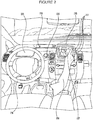
FIGURE 2 is an interior of an autonomous vehicle in accordance with aspects of the disclosure. -
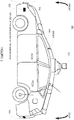
FIGURE 3 is an exterior of an autonomous vehicle in accordance with aspects of the disclosure. -
FIGURE 4 is an example of a roadway in accordance with aspects of the disclosure. -
FIGURE 5 is an example of detailed map information in accordance with aspects of the disclosure. -
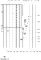
FIGURE 6 is another example of detailed map information in accordance with aspects of the disclosure. -
FIGURE 7A is a pictorial diagram of a system in accordance with aspects of the disclosure. -
FIGURE 7B is a functional diagram of a system in accordance with aspects of the disclosure. -
FIGURE 8 is another example of the roadway ofFIGURE 4 in accordance with aspects of the disclosure. -
FIGURE 9 is another example of the roadway ofFIGURE 4 in accordance with aspects of the disclosure. -
FIGURE 10 is another example of the roadway ofFIGURE 4 in accordance with aspects of the disclosure. -
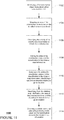
FIGURE 11 is an example flow diagram in accordance with aspects of the disclosure. - The disclosure relates generally to mapping and classifying construction zones in order to improve safety and efficiency of autonomous vehicles. As an example, a first vehicle with access to a detailed map may be driven along a roadway in an autonomous or manual driving mode. The first vehicle may use its sensors to detect a construction zone, for example, by identifying a construction object such as a road work sign, cone, barrel, fence, construction vehicle, flare, or other items commonly associated with construction zones. Where the vehicle is being driven in an autonomous mode, upon identifying the construction object, the vehicle may switch to a manual mode or a very cautious driving mode. As the first vehicle is driving (or after it has driven) through the construction zone, the first vehicle may map the area of the construction zone and incorporate this construction zone information into the detailed map.
- By comparing the detailed map information to the features of the roadway detected in the construction zone, such as the positioning of lane lines, whether lanes are closed, the presence and location of a new k-rail, etc., the first vehicle may determine whether the construction zone is active or inactive. In this regard, if changes to the aforementioned features are identified, then the construction zone may be classified as active. If no changes (or very minor changes) are identified, then the construction zone may be classified as inactive. This information may be associated with the construction zone information and incorporated into the detailed map. This information may also be shared with other vehicles in order to update their own detailed maps.
- A second vehicle (or the first vehicle at a later time), may detect the construction zone by detecting a construction object such as road work signs, cones, barrels, fences, construction vehicles, flares, or other items commonly associated with construction zones. The second vehicle may then access the detailed map to determine whether the location of the detected construction object corresponds to a construction zone included and if so, whether the status of the construction zone associated with the detected object is identified as active or inactive. If the construction zone is active, the second vehicle may user a higher level of caution, by driving very slowly and perhaps transitioning from an autonomous to a manual mode. If the construction zone is inactive, the vehicle may continue to drive normally based on the information in the map. If the detected object is not in the map, the second vehicle may be driven under the higher level of caution and may add the detected object to the map. In addition, the second vehicle may also reclassify the construction zone.
- As shown in
FIGURE 1 , anautonomous driving system 100 in may include avehicle 101 with various components. While certain aspects of the disclosure are particularly useful in connection with specific types of vehicles, the vehicle may be any type of vehicle including, but not limited to, cars, trucks, motorcycles, busses, boats, airplanes, helicopters, lawnmowers, recreational vehicles, amusement park vehicles, farm equipment, construction equipment, trams, golf carts, trains, and trolleys. The vehicle may have one or more computers, such ascomputer 110 containing aprocessor 120,memory 130 and other components typically present in general purpose computers. - The
memory 130 stores information accessible byprocessor 120, includinginstructions 132 anddata 134 that may be executed or otherwise used by theprocessor 120. Thememory 130 may be of any type capable of storing information accessible by the processor, including a computer-readable medium, or other medium that stores data that may be read with the aid of an electronic device, such as a hard-drive, memory card, ROM, RAM, DVD or other optical disks, as well as other write-capable and read-only memories. Systems and methods may include different combinations of the foregoing, whereby different portions of the instructions and data are stored on different types of media. - The
instructions 132 may be any set of instructions to be executed directly (such as machine code) or indirectly (such as scripts) by the processor. For example, the instructions may be stored as computer code on the computer-readable medium. In that regard, the terms "instructions" and "programs" may be used interchangeably herein. The instructions may be stored in object code format for direct processing by the processor, or in any other computer language including scripts or collections of independent source code modules that are interpreted on demand or compiled in advance. Functions, methods and routines of the instructions are explained in more detail below. - The
data 134 may be retrieved, stored or modified byprocessor 120 in accordance with theinstructions 132. For instance, although the claimed subject matter is not limited by any particular data structure, the data may be stored in computer registers, in a relational database as a table having a plurality of different fields and records, XML documents or flat files. The data may also be formatted in any computer-readable format. By further way of example only, image data may be stored as bitmaps comprised of grids of pixels that are stored in accordance with formats that are compressed or uncompressed, lossless (e.g., BMP) or lossy (e.g., JPEG), and bitmap or vector-based (e.g., SVG), as well as computer instructions for drawing graphics. The data may comprise any information sufficient to identify the relevant information, such as numbers, descriptive text, proprietary codes, references to data stored in other areas of the same memory or different memories (including other network locations) or information that is used by a function to calculate the relevant data. - The
processor 120 may be any conventional processor, such as commercially available CPUs. Alternatively, the processor may be a dedicated device such as an ASIC or other hardware-based processor. AlthoughFIGURE 1 functionally illustrates the processor, memory, and other elements ofcomputer 110 as being within the same block, it will be understood by those of ordinary skill in the art that the processor, computer, or memory may actually comprise multiple processors, computers, or memories that may or may not be stored within the same physical housing. For example, memory may be a hard drive or other storage media located in a housing different from that ofcomputer 110. Accordingly, references to a processor or computer will be understood to include references to a collection of processors or computers or memories that may or may not operate in parallel. Rather than using a single processor to perform the steps described herein, some of the components, such as steering components and deceleration components, may each have their own processor that only performs calculations related to the component's specific function. - In various aspects described herein, the processor may be located remote from the vehicle and communicate with the vehicle wirelessly. In other aspects, some of the processes described herein are executed on a processor disposed within the vehicle and others by a remote processor, including taking the steps necessary to execute a single maneuver.
-
Computer 110 may include all of the components normally used in connection with a computer such as a central processing unit (CPU), memory (e.g., RAM and internal hard drives) storingdata 134 and instructions such as a web browser, an electronic display 152 (e.g., a monitor having a screen, a small LCD touch-screen or any other electrical device that is operable to display information), user input 150 (e.g., a mouse, keyboard, touch screen and/or microphone), as well as various sensors (e.g., a video camera) for gathering explicit (e.g., a gesture) or implicit (e.g., "the person is asleep") information about the states and desires of a person. - In one example,
computer 110 may be an autonomous driving computing system incorporated intovehicle 101.FIGURE 2 depicts an exemplary design of the interior of an autonomous vehicle. The autonomous vehicle may include all of the features of a non-autonomous vehicle, for example: a steering apparatus, such assteering wheel 210; a navigation display apparatus, such as navigation display 215 (which may be a part of electronic display 152); and a gear selector apparatus, such asgear shifter 220. The vehicle may also have varioususer input devices 140 in addition to the foregoing, such as touch screen 217 (which may be a part of electronic display 152), orbutton inputs 219, for activating or deactivating one or more autonomous driving modes and for enabling a driver orpassenger 290 to provide information, such as a navigation destination, to theautonomous driving computer 110. - The autonomous driving computing system may be capable of communicating with various components of the vehicle. For example, returning to
FIGURE 1 ,computer 110 may be in communication with the vehicle'scentral processor 160 and may send and receive information from the various systems ofvehicle 101, for example thebraking system 180,acceleration system 182, signalingsystem 184, andnavigation system 186 in order to control the movement, speed, etc. ofvehicle 101. In one example, the vehicle'scentral processor 160 may perform all of the functions of a central processor in a non-autonomous computer. In another example,processor - In addition, when engaged,
computer 110 may control some or all of these functions ofvehicle 101. Thusvehicle 101 may have various manual, semiautonomous, or autonomous driving modes as described above. It will be understood that although various systems andcomputer 110 are shown withinvehicle 101, these elements may be external tovehicle 101 or physically separated by large distances. - The vehicle may also include a
geographic position component 144 in communication withcomputer 110 for determining the geographic location of the device. For example, the position component may include a GPS receiver to determine the device's latitude, longitude and/or altitude position. Other location systems such as laser-based localization systems, inertial-aided GPS, or camera-based localization may also be used to identify the location of the vehicle. The location of the vehicle may include an absolute geographical location, such as latitude, longitude, and altitude as well as relative location information, such as location relative to other cars immediately around it, which can often be determined with better accuracy than absolute geographical location. - The vehicle may also include other devices in communication with
computer 110, such as an accelerometer, gyroscope or another direction/speed detection device 146 to determine the direction and speed of the vehicle or changes thereto. By way of example only,acceleration device 146 may determine its pitch, yaw or roll (or changes thereto) relative to the direction of gravity or a plane perpendicular thereto. The device may also track increases or decreases in speed and the direction of such changes. The device's provision of location and orientation data as set forth herein may be provided automatically to the user,computer 110, other computers and combinations of the foregoing. - The
computer 110 may control the direction and speed of the vehicle by controlling various components. By way of example, if the vehicle is operating in a completely autonomous driving mode,computer 110 may cause the vehicle to accelerate (e.g., by increasing fuel or other energy provided to the engine), decelerate (e.g., by decreasing the fuel supplied to the engine or by applying brakes) and change direction (e.g., by turning the front two wheels). - The vehicle may also include components for detecting objects external to the vehicle such as other vehicles, obstacles in the roadway, traffic signals, signs, trees, etc. The
detection system 154 may include lasers, sonar, radar, cameras or any other detection devices which record data which may be processed bycomputer 110. For example, if the vehicle is a small passenger vehicle, the car may include a laser mounted on the roof or other convenient location. - As shown in
FIGURE 3 ,vehicle 101 may include a small passengervehicle having lasers Laser 310 may have a range of approximately 150 meters, a thirty degree vertical field of view, and approximately a thirty degree horizontal field of view.Laser 311 may have a range of approximately 50-80 meters, a thirty degree vertical field of view, and a 360 degree horizontal field of view. The lasers may provide the vehicle with range and intensity information which the computer may use to identify the location and distance of various objects. In one aspect, the lasers may measure the distance between the vehicle and the object surfaces facing the vehicle by spinning on its axis and changing its pitch. - The vehicle may also include various radar detection units, such as those used for adaptive cruise control systems. The radar detection units may be located on the front and back of the car as well as on either side of the front bumper. As shown in the example of
FIGURE 3 ,vehicle 101 includes radar detection units 320-323 located on the side (only one side being shown), front and rear of the vehicle. Each of these radar detection units may have a range of approximately 200 meters for an approximately 18 degree field of view as well as a range of approximately 60 meters for an approximately 56 degree field of view. - In another example, a variety of cameras may be mounted on the vehicle. The cameras may be mounted at predetermined distances so that the parallax from the images of 2 or more cameras may be used to compute the distance to various objects. As shown in
FIGURE 3 ,vehicle 101 may include 2 cameras 330-331 mounted under awindshield 340 near the rear view mirror (not shown). Camera 330 may include a range of approximately 200 meters and an approximately 30 degree horizontal field of view, while camera 331 may include a range of approximately 100 meters and an approximately 60 degree horizontal field of view. - In addition to the sensors described above, the computer may also use input from other sensors and features typical to non-autonomous vehicles. For example, these other sensors and features may include tire pressure sensors, engine temperature sensors, brake heat sensors, break pad status sensors, tire tread sensors, fuel sensors, oil level and quality sensors, air quality sensors (for detecting temperature, humidity, or particulates in the air), door sensors, lights, wipers, etc. This information may be provided directly from these sensors and features or via the vehicle's
central processor 160. - Many of these sensors provide data that is processed by the computer in real-time, that is, the sensors may continuously update their output to reflect the environment being sensed at or over a range of time, and continuously or as-demanded provide that updated output to the computer so that the computer can determine whether the vehicle's then-current direction or speed should be modified in response to the sensed environment.
- In addition to processing data provided by the various sensors, the computer may rely on environmental data that was obtained at a previous point in time and is expected to persist regardless of the vehicle's presence in the environment. For example, returning to
FIGURE 1 ,data 134 may includedetailed map information 136, e.g., highly detailed maps identifying the shape and elevation of roadways, lane lines, intersections, crosswalks, speed limits, traffic signals, buildings, signs, real time traffic information, vegetation, or other such objects and information. For example, the map information may include explicit speed limit information associated with various roadway segments. The speed limit data may be entered manually or scanned from previously taken images of a speed limit sign using, for example, optical-character recognition. -
FIGURE 4 is an example of ahighway 400. In this example,highway 400 includes 3 northbound lanes 410-412 and 3 southbound lanes 420-22 defined by broken lane lines 430-33 and solid lane lines 440-43.Highway 400 also includes shoulders 450-51 defined betweensolid lane line 440 andbarrier 460 andsolid lane line 441 andbarrier 461, respectively. Between the northbound and southbound lanes,highway 400 includes a median 470 which definesshoulders lane lines -
FIGURE 5 is an example ofdetailed map information 500 forhighway 400.Detailed map information 500 may be a portion of thedetailed map information 136 and may include data indicating the location and orientation of the various features ofhighway 400. For example,detailed map information 500 includes northbound lane data 510-512 identifying northbound lanes 410-412 as well as southbound lane data 520-522 identifying southbound lanes 420-22.Detailed map information 500 also includes broken lane line data 530-33 and solid lane lines 540-43 representing broken lane lines 430-33 and solid lane lines 440-43. Shoulders 450-53 are also represented by shoulder data 550-553. Barriers 460-61 are represented by barrier data 560-61, and median 470 is represented bymedian data 570. - The detailed map information may also include information regarding construction zone areas. This may include location information defining the boundaries of construction zone areas. For example,
FIGURE 6 is an example ofmap information 500 includingconstruction zone areas - These construction zone areas may also be associated with a classification based on the most recent analysis of the activity of the construction zone. As an example, a construction zone area may be classified as active or inactive depending upon the characteristics of the features in the construction zone area. Referring to
FIGURE 6 construction zone area 610 includes anactive designation 630 andconstruction zone area 620 includes aninactive designation 640. - Although the
detailed map information 136 is depicted herein as an image-based map, the map information need not be entirely image based (for example, raster). The map information may include one or more roadgraphs or graph networks of information such as roads, lanes, intersections, and the connections between these features. Each feature may be stored as graph data and may be associated with information such as a geographic location whether or not it is linked to other related features. For example, a stop sign may be linked to a road and an intersection. In some examples, the associated data may include grid-based indices of a roadgraph to promote efficient lookup of certain roadgraph features. -
Computer 110 may also receive or transfer information to and from other computers. For example, the map information stored bycomputer 110 may be received or transferred from other computers and/or the sensor data collected from the sensors ofvehicle 101 may be transferred to another computer for processing as described herein. As shown inFIGURES 7A and 7B , data fromcomputer 110, such as sensor information, may be transmitted via a network to acentral processing computer 720 for further processing. Similarly, data fromcomputer 720, such as software updates or weather information as described below, may be transmitted via the network tocomputer 110 or other similar computers of other vehicles having an autonomous driving mode. - The network, and intervening nodes, may comprise various configurations and protocols including the Internet, World Wide Web, intranets, virtual private networks, wide area networks, local networks, private networks using communication protocols proprietary to one or more companies, Ethernet, WiFi and HTTP, and various combinations of the foregoing. Such communication may be facilitated by any device capable of transmitting data to and from other computers, such as modems and wireless interfaces. In another example, data may be transferred by storing it on memory which may be accessed by or connected to
computers - In one example,
computer 720 may comprise a server having a plurality of computers, e.g., a load balanced server farm, that exchange information with different nodes of a network for the purpose of receiving, processing and transmitting the data to and fromcomputer 110. The server may be configured similarly to thecomputer 110, with aprocessor 730,memory 740,instructions 750, anddata 760. - In addition to the operations described above and illustrated in the figures, various operations will now be described. It should be understood that the following operations do not have to be performed in the precise order described below. Rather, various steps can be handled in a different order or simultaneously, and steps may also be added or omitted.
- As an example, a first vehicle may be driven along a roadway. This first vehicle may include
vehicle 101 and may be operating in an autonomous driving mode, a manual driving mode, or a mode that lies somewhere between these. Alternatively, this first vehicle may also be a non-autonomous vehicle driven simply for the purpose of collecting sensor information about the environment. -
FIGURE 8 is an example ofvehicle 101 driving along North-boundlane 410 ofroadway 400 whereconstruction vehicles vehicle 101 is approaching a construction zone as indicated by thevarious construction objects shoulder 453 is closed. - As the vehicle is driven, sensors may collect information about the vehicle's environment. The information from the vehicle's sensors may be used to detect construction zones. For example, sensor information may be used to identify construction objects such as road work signs, cones, barrels, fences, construction vehicles, flares, or other items commonly associated with construction zones. For example,
computer 110 ofvehicle 101 may detectconstruction objects construction objects - These construction objects may be identified using any number of techniques such as by comparison of sensor data to the detailed map information, image matching, probability filters, image templates, etc. For example, techniques described in
U.S. Patent No. 8,195,394 ,U.S. Patent Application No. 13/361,083 , entitled VEHICLE CONTROL BASED ON PERCEPTION UNCERTAINTY, and/orU.S. Patent Application No 13/799,829 , entitled HIGH-ACCURACY REAL-TIME ROAD SIGN DETECTION FROM IMAGES, may be used to identify construction objects. - In some examples, where the vehicle is being driven in an autonomous mode, upon identifying a construction object, the vehicle may automatically warn the driver and switch to a manual mode. Alternatively, the vehicle may warn the driver and
computer 110 may switch to a very cautious driving mode, for example, by driving more slowly, increasing the distance between the vehicle and other objects in the roadway, etc. - Once a construction object is detected, the construction area may be mapped. For example,
computer 110 may detect any number of additional construction objects or determine when the features of the roadway once again correspond to the detailed map information. Thus, a starting point, based on the location of the first construction object, and an ending point may be identified based on the location of the last identified construction object. The area along the roadway between these points may be the construction zone. In some examples, some buffer area may be added to the construction area by adding some distance beyond the last detected construction object. - As an example,
computer 110 may detectconstruction object 810 and begin mapping a construction area. Once the last construction object has been detected, such asconstruction object 860,computer 110 may use this information to define aconstruction zone area 910 ofFIGURE 9 . Similarly, a vehicle detectingconstruction objects construction zone 1010 ofFIGURE 10 . - In addition to mapping the construction zone, it may also be classified by the system. As an example, a construction zone may be classified as active or inactive based on upon the characteristics of the construction zones. This classification may be accomplished by comparing the detailed map information to the features, other than those used to identify the construction zone, of the roadway detected in the construction zone. This may include comparing the positioning of lane lines, whether lanes are closed, the presence and location of a new k-rail or other barrier, etc. If any differences or changes to the aforementioned features are identified, then the construction zone may be classified as active. If no changes or very minor changes, are identified, then the construction zone may be classified as inactive. Examples of minor changes may include those that would not affect the autonomous driving, such as changes outside of the road lanes including shoulder work or moving a divider in a way that would not affect the vehicle's localization systems, or a slight lane shift that is small enough that driving within the previously mapped lane from the detailed map information would still be safe or comfortable to the driver.
- Referring to the examples of
FIGURES 8 and9 ,construction zone 910 may be classified as active as portions oflane lines FIGURES 8 and10 ,construction zone 1010 may be classified as inactive as there would not be any differences from the detailed map information other than the appearance of the construction objects. - The aforementioned identifications and classifications of construction zones may be done at a later time by a computer other than that of the vehicle which collected the sensor information. For example, a computer such as
server 720 may be used to process the sensor information in order to identify the construction objects and map a construction zone. Alternatively, this identification and classification may be performed by a computer of the vehicle that collected the sensor information, such ascomputer 110 ofvehicle 101 as described above. By using a computer of the vehicle to do the identifications and classifications of construction zones in real time, this may increase the usefulness of the classification as described in more detail below. - The area of the construction zone and the classification information may be associated with one another and incorporated into detailed map information for vehicles having an autonomous driving mode. Thus,
computer 110 may store this information in the detailed map information.FIGURE 6 includesdetailed map information 500 havingconstruction zone areas construction zone areas FIGURES 9 and10 stored in thedetailed map information 136. Again,FIGURE 6 includesclassifications construction zones server 720 which may relay the information to other vehicles having an autonomous driving mode. - Alternatively, if the identification and classification of a construction zone is performed by a computer such as
server 720, the construction zones and associated classifications may be transmitted to other autonomous vehicles and stored with their respective detailed map information. - If the identification and classification of a construction zone is performed by an autonomous vehicle such as
vehicle 101, this information may be stored directly withvehicle 101's detailed map information This information may also be shared with other vehicles in order to update their own detailed maps, for example, by sending it directly to specific vehicles, a broadcast to all other autonomous vehicles, or by sending it to a computer such asserver 720 which may then send it to other autonomous vehicles. - At some later time, a second vehicle, such as
vehicle 101, operating in an autonomous driving mode may detect a construction zone. This may be done by identifying a first construction object commonly associated with a construction zone as described above.Computer 110 ofvehicle 101 may then query the detailed map information to determine whether there is a construction zone associated with the location of the identified first construction object. If not,computer 110 may proceed by mapping the construction zone, classifying the construction zone, storing this information with the detailed map information, and, in some examples, sending it to other autonomous vehicle as described above. - If the location of the identified first construction object is associated with the detailed map information, the
computer 110 may also identify the classification associated with that construction zone and use the classification to determine how to drive the autonomous vehicle. Using the example above, when the construction zone is classified as active, the second vehicle may user a higher level of caution, by driving very slowly and perhaps transitioning from an autonomous to a manual mode. Similarly, when the construction zone is classified as inactive, the vehicle may continue to drive normally based on the detailed map information. -
Computer 110 may also determine whether it becomes necessary to reclassify a construction zone, for example by changing the classification of a construction zone from active to inactive or inactive to active based upon the features of the roadway and the detailed map information as described above. - Flow diagram 1100 of
FIGURE 11 is an example of some of the aspects described above which may be performed all or in part bycomputer 110 ofvehicle 101. In this example, the computer identifies a first construction object associated with a construction zone atblock 1102. An area of the construction zone is mapped based on the identified construction object atblock 1104. The computer then classifies the activity of the construction zone based on detailed map information atblock 1106. For example, a construction zones may be classified as active or inactive. The area of the construction zone and the classification are added to the detailed map information atblock 1108. - Subsequent to adding the construction zone and the classification to the detailed map information, the computer identifies a second construction object at a given location at
block 1110. The computer then identifies from the detailed map information, the area of the construction zone and the classification based on the given location atblock 1112. The computer then operates a vehicle having an autonomous driving mode based on the classification stored in the detailed map information atblock 1114. - In an alternative, rather than simply classifying a construction zone as active or inactive, other classifications schemes may be used. For example, the classifications may be associated with or simply be different pieces of information regarding how the vehicle should respond. As an example, some construction zones may have a time component, such as where road work on a highway is performed only during night hours (9:00 pm to 5:00 am, etc.). Thus, the vehicle need only be driven manually or extra cautiously close to these hours. In another example, there may be ongoing construction which only sometimes affects a particular lane. This is example, the
computer 110 would need to know which lane is affected and what thecomputer 110 should look for when approaching the area, such as whether there are any cones near the particular lane, thecomputer 110 can be highly confident that the particular lane is in fact affected or closed. In another example, if the driving lanes are not affected by a construction project, but there is active work occurring close to the lanes on the shoulder, it may be safer to drive the vehicle slowly through the area of the construction zone, though not necessary. These details may also be associated with or simply used to classify the construction zone. - The features described above allow a vehicle having an autonomous driving mode to transition into another driving mode when there is a real need for it, but also to drive normally when there is not. As noted above without the classifications, the vehicle would always have to transition to the manual mode when it detects a construction object in order to promote a safe driving experience, even where it would not be necessary, such as in the example of
construction zone area 1010/620. However, as noted above, because of the classification features provided above, the autonomous vehicle may continue in the autonomous mode. Thus, the classifications allow the vehicle's computer to make a much more informed decision about how to operate in a construction zone. - As these and other variations and combinations of the features discussed above can be utilized without departing from the subject matter as defined by the claims, the foregoing description of exemplary embodiments should be taken by way of illustration rather than by way of limitation of the subject matter as defined by the claims. It will also be understood that the provision of the examples described herein (as well as clauses phrased as "such as," "e.g.", "including" and the like) should not be interpreted as limiting the claimed subject matter to the specific examples; rather, the examples are intended to illustrate only some of many possible aspects.
- The present invention enjoys wide industrial applicability including, but not limited to, mapping active and inactive construction zones for use by a vehicle in an autonomous driving mode.
- The specification includes the following subject-matter expressed in the form of clauses 1-20:
CLAUSES 1-20: - 1. A method comprising:
- identifying a first construction object associated with a construction zone;
- mapping an area of the construction zone based on the identified construction object;
- classifying, by a processor, an activity type of the construction zone based on detailed map information;
- adding the area of the construction zone and the classification to the detailed map information;
- subsequent to adding the construction zone and the classification to the detailed map information, identifying a second construction object at a given location;
- identifying, from the detailed map information, the area of the construction zone and the classification based on the given location; and
- operating, at the area of the construction zone, a vehicle having an autonomous driving mode based on the classification stored in the detailed map information.
- 2. The method of clause 1, wherein classifying the activity type of the construction zone includes determining whether there have been any changes to the area of the construction zone from the detailed map information.
- 3. The method of clause 1, wherein the activity type of the construction zone is classified as inactive when the features of the construction zone correspond to the features of the detailed map information for that area.
- 4. The method of clause 3, wherein when the activity type of the construction zone is classified as inactive, operating the vehicle based on the classification includes operating the vehicle in the autonomous driving mode through the area of the construction zone.
- 5. The method of clause 1, wherein the activity type of the construction zone is classified as active when the features of the construction zone indicate that there have been changes to the roadway as compared to the detailed map information.
- 6. The method of clause 5, wherein when the activity type of the construction zone is classified as active, operating the vehicle based on the classification includes operating the vehicle in the manual driving mode through the area of the construction zone.
- 7. The method of clause 1, wherein operating the vehicle based on the classification includes determining whether to drive the vehicle in the autonomous driving mode or a manual driving mode.
- 8. The method of clause 1, further comprising, after operating the vehicle based on the classification:
- reclassifying the activity type of the construction zone; and
- updating the classification of the construction zone in the detailed map information based on the reclassifying.
- 9. The method of clause 8, further comprising sending the updated classification to a remote computer.
- 10. The method of clause 1, wherein the second construction object is the first construction object.
- 11. A method comprising:
- receiving information identifying a construction zone and a classification of an activity type of the construction zone;
- adding an area of the construction zone and the classification to detailed map information;
- subsequent to adding the area of the construction zone and the classification to the detailed map information, identifying, by a processor, a construction object at a given location; and
- operating a vehicle having an autonomous driving mode based on the classification stored in the detailed map information.
- 12. The method of clause 1, further comprising, after operating the vehicle based on the classification:
- reclassifying the activity type of the construction zone; and
- updating the classification of the construction zone in the detailed map information based on the reclassifying.
- 13. The method of clause 11, wherein operating the vehicle based on the classification includes determining whether to drive the vehicle in the autonomous driving mode or a manual driving mode.
- 14. The method of clause 11, wherein the information identifying the construction zone is further received with instructions for controlling the driving behaviors of the vehicle in the area of the construction zone and wherein operating the vehicle is further based on the instructions for controlling the driving behaviors.
- 15. A system comprising:
- memory storing detailed map information;
- a processor configured to:
- identify a first construction object associated with a construction zone;
- map an area of the construction zone based on the identified construction object;
- classify an activity type of the construction zone based on the detailed map information;
- add the area of the construction zone and the classification to the detailed map information;
- subsequent to adding the construction zone and the classification to the detailed map information, identify a second construction object at a given location;
- identify, from the detailed map information, the area of the construction zone and the classification based on the given location; and
- operate, at the area of the construction zone, a vehicle having an autonomous driving mode based on the classification stored in the detailed map information.
- 16. The system of clause 15, wherein classifying the activity type of the construction zone includes determining whether there have been any changes to the area of the construction zone from the detailed map information.
- 17. The system of clause 15, wherein the activity type of the construction zone is classified as inactive when the features of the construction zone correspond to the features of the detailed map information for that area.
- 18. The system of clause 15, wherein operating the vehicle based on the classification includes determining whether to drive the vehicle in the autonomous driving mode or a manual driving mode.
- 19. The system of clause 15, wherein the processor is further configured to, after operating the vehicle based on the classification:
- reclassify the activity type of the construction zone; and
- update the classification of the construction zone in the detailed map information based on the reclassifying.
- 20. The system of clause 15, wherein the processor is further configured to:
- generate instructions for controlling the driving behaviors of the vehicle in the area of the construction zone; and
- add the instructions for controlling the driving behaviors of the vehicle to the detailed map information with the area of the construction zone and the classification, wherein operating, at the area of the construction zone, is further based on the instructions for controlling the driving behaviors of the vehicle.
Claims (15)
- A method for operating a vehicle having an autonomous driving mode, the method comprising:classifying, by one or more processors, from a plurality of classifications comprising active and inactive classifications, an activity type of a construction zone based on changes in roadway features of the construction zone relative to stored map information at a location of the construction zone;updating, by the one or more processors, a first classification for the construction zone in the map information to a second classification based on the activity type; andoperating, at an area of the construction zone, the vehicle, by the one or more processors, based on the second classification.
- The method of claim 1, wherein the first classification is different from the second classification.
- The method of claim 1 or 2, further comprising determining whether the first classification should be updated based on the activity type, and wherein updating the first classification is based on the determination.
- The method of any of claims 1-3, further comprising receiving sensor data identifying features in an environment of the vehicle, and wherein the classifying includes comparing the map information to the identified features.
- The method of claim 4,wherein the features include a lane line and a location of the lane line; orwherein the identified features include a closed lane; orwherein the identified features include a barrier; orwherein the identified features do not include construction objects.
- The method of claim 4, further comprising determining whether there is a corresponding feature in the map information, and wherein the classifying is further based on the determination.
- The method of claim 4, further comprising using the comparison to identify differences between any of the identified features and the map information, and wherein the classifying is further based on the identified differences.
- The method of claim 7, wherein the differences correspond to identified features other than construction objects.
- The method of claim 8, further comprising determining whether the identified differences would impact autonomous driving of the vehicle, and wherein the determination of whether the identified differences would impact autonomous driving of the vehicle is used to classify the activity type.
- The method of claim 9, wherein when the identified differences are determined to not impact the autonomous driving of the vehicle, the activity type corresponds to an inactive activity type.
- The method of any preceding claim,wherein when the activity type corresponds to an active activity type, operating the vehicle includes decreasing a speed of the vehicle; orwherein when the activity type corresponds to an active activity type, operating the vehicle includes using caution when moving through the area of the construction zone; or• wherein when the activity type corresponds to an active activity type, operating the vehicle includes transitioning the vehicle from the autonomous driving mode to a manual driving mode
- The method of any preceding claim, wherein when the activity type corresponds to an inactive activity type, operating the vehicle in a same way as the vehicle operates outside of the area of the construction zone.
- The method of any preceding claim, wherein the activity type is classified as either active or inactive.
- A system for operating a vehicle having an autonomous driving mode, the system comprising one or more processors configured to perform the method of any preceding claim.
- The system of claim 14, further comprising the vehicle.
Applications Claiming Priority (3)
| Application Number | Priority Date | Filing Date | Title |
|---|---|---|---|
| US13/859,990 US9141107B2 (en) | 2013-04-10 | 2013-04-10 | Mapping active and inactive construction zones for autonomous driving |
| PCT/US2014/033325 WO2014168944A1 (en) | 2013-04-10 | 2014-04-08 | Mapping active and inactive construction zones for autonomous driving |
| EP14782618.4A EP2984642B1 (en) | 2013-04-10 | 2014-04-08 | Mapping active and inactive construction zones for autonomous driving |
Related Parent Applications (2)
| Application Number | Title | Priority Date | Filing Date |
|---|---|---|---|
| EP14782618.4A Division EP2984642B1 (en) | 2013-04-10 | 2014-04-08 | Mapping active and inactive construction zones for autonomous driving |
| EP14782618.4A Division-Into EP2984642B1 (en) | 2013-04-10 | 2014-04-08 | Mapping active and inactive construction zones for autonomous driving |
Publications (1)
| Publication Number | Publication Date |
|---|---|
| EP3757965A1 true EP3757965A1 (en) | 2020-12-30 |
Family
ID=51687337
Family Applications (2)
| Application Number | Title | Priority Date | Filing Date |
|---|---|---|---|
| EP20191737.4A Withdrawn EP3757965A1 (en) | 2013-04-10 | 2014-04-08 | Mapping active and inactive construction zones for autonomous driving |
| EP14782618.4A Active EP2984642B1 (en) | 2013-04-10 | 2014-04-08 | Mapping active and inactive construction zones for autonomous driving |
Family Applications After (1)
| Application Number | Title | Priority Date | Filing Date |
|---|---|---|---|
| EP14782618.4A Active EP2984642B1 (en) | 2013-04-10 | 2014-04-08 | Mapping active and inactive construction zones for autonomous driving |
Country Status (6)
| Country | Link |
|---|---|
| US (6) | US9141107B2 (en) |
| EP (2) | EP3757965A1 (en) |
| JP (3) | JP6178914B2 (en) |
| KR (1) | KR101636666B1 (en) |
| CN (2) | CN105210128B (en) |
| WO (1) | WO2014168944A1 (en) |
Families Citing this family (144)
| Publication number | Priority date | Publication date | Assignee | Title |
|---|---|---|---|---|
| US9056395B1 (en) * | 2012-09-05 | 2015-06-16 | Google Inc. | Construction zone sign detection using light detection and ranging |
| US8996228B1 (en) * | 2012-09-05 | 2015-03-31 | Google Inc. | Construction zone object detection using light detection and ranging |
| US10377374B1 (en) | 2013-11-06 | 2019-08-13 | Waymo Llc | Detection of pedestrian using radio devices |
| TW201524813A (en) * | 2013-12-27 | 2015-07-01 | Hon Hai Prec Ind Co Ltd | Vehicle assistance system and vehicle assistance method |
| US9547989B2 (en) * | 2014-03-04 | 2017-01-17 | Google Inc. | Reporting road event data and sharing with other vehicles |
| US9858621B1 (en) | 2014-05-20 | 2018-01-02 | State Farm Mutual Automobile Insurance Company | Autonomous vehicle technology effectiveness determination for insurance pricing |
| US10373259B1 (en) | 2014-05-20 | 2019-08-06 | State Farm Mutual Automobile Insurance Company | Fully autonomous vehicle insurance pricing |
| US11669090B2 (en) | 2014-05-20 | 2023-06-06 | State Farm Mutual Automobile Insurance Company | Autonomous vehicle operation feature monitoring and evaluation of effectiveness |
| US9972054B1 (en) | 2014-05-20 | 2018-05-15 | State Farm Mutual Automobile Insurance Company | Accident fault determination for autonomous vehicles |
| CN107624155B (en) | 2014-12-05 | 2021-09-28 | 苹果公司 | Autonomous Navigation System |
| EP3234626A4 (en) * | 2014-12-18 | 2018-08-22 | Innerspace Technology Inc. | Method and system for sensing interior spaces to auto-generate a navigational map |
| JP2016206774A (en) * | 2015-04-17 | 2016-12-08 | トヨタ自動車株式会社 | Three-dimensional object detection apparatus and three-dimensional object detection method |
| WO2016170785A1 (en) * | 2015-04-21 | 2016-10-27 | パナソニックIpマネジメント株式会社 | Information processing system, information processing method, and program |
| US20160349754A1 (en) | 2015-05-29 | 2016-12-01 | Clearpath Robotics, Inc. | Method, system and apparatus for controlling self-driving vehicles |
| JP6776513B2 (en) * | 2015-08-19 | 2020-10-28 | ソニー株式会社 | Vehicle control device, vehicle control method, information processing device, and traffic information provision system |
| US10000124B2 (en) | 2015-11-04 | 2018-06-19 | Zoox, Inc. | Independent steering, power, torque control and transfer in vehicles |
| US9910441B2 (en) | 2015-11-04 | 2018-03-06 | Zoox, Inc. | Adaptive autonomous vehicle planner logic |
| US10745003B2 (en) | 2015-11-04 | 2020-08-18 | Zoox, Inc. | Resilient safety system for a robotic vehicle |
| US9804599B2 (en) | 2015-11-04 | 2017-10-31 | Zoox, Inc. | Active lighting control for communicating a state of an autonomous vehicle to entities in a surrounding environment |
| US9701239B2 (en) | 2015-11-04 | 2017-07-11 | Zoox, Inc. | System of configuring active lighting to indicate directionality of an autonomous vehicle |
| WO2017079341A2 (en) | 2015-11-04 | 2017-05-11 | Zoox, Inc. | Automated extraction of semantic information to enhance incremental mapping modifications for robotic vehicles |
| US9632502B1 (en) | 2015-11-04 | 2017-04-25 | Zoox, Inc. | Machine-learning systems and techniques to optimize teleoperation and/or planner decisions |
| US10496766B2 (en) | 2015-11-05 | 2019-12-03 | Zoox, Inc. | Simulation system and methods for autonomous vehicles |
| US9734455B2 (en) | 2015-11-04 | 2017-08-15 | Zoox, Inc. | Automated extraction of semantic information to enhance incremental mapping modifications for robotic vehicles |
| US9494940B1 (en) | 2015-11-04 | 2016-11-15 | Zoox, Inc. | Quadrant configuration of robotic vehicles |
| US9612123B1 (en) | 2015-11-04 | 2017-04-04 | Zoox, Inc. | Adaptive mapping to navigate autonomous vehicles responsive to physical environment changes |
| US9720415B2 (en) | 2015-11-04 | 2017-08-01 | Zoox, Inc. | Sensor-based object-detection optimization for autonomous vehicles |
| US12265386B2 (en) | 2015-11-04 | 2025-04-01 | Zoox, Inc. | Autonomous vehicle fleet service and system |
| US9754490B2 (en) | 2015-11-04 | 2017-09-05 | Zoox, Inc. | Software application to request and control an autonomous vehicle service |
| US9878664B2 (en) | 2015-11-04 | 2018-01-30 | Zoox, Inc. | Method for robotic vehicle communication with an external environment via acoustic beam forming |
| US9958864B2 (en) | 2015-11-04 | 2018-05-01 | Zoox, Inc. | Coordination of dispatching and maintaining fleet of autonomous vehicles |
| US9802661B1 (en) | 2015-11-04 | 2017-10-31 | Zoox, Inc. | Quadrant configuration of robotic vehicles |
| US10401852B2 (en) | 2015-11-04 | 2019-09-03 | Zoox, Inc. | Teleoperation system and method for trajectory modification of autonomous vehicles |
| US10334050B2 (en) | 2015-11-04 | 2019-06-25 | Zoox, Inc. | Software application and logic to modify configuration of an autonomous vehicle |
| US11283877B2 (en) | 2015-11-04 | 2022-03-22 | Zoox, Inc. | Software application and logic to modify configuration of an autonomous vehicle |
| US9606539B1 (en) | 2015-11-04 | 2017-03-28 | Zoox, Inc. | Autonomous vehicle fleet service and system |
| US9916703B2 (en) | 2015-11-04 | 2018-03-13 | Zoox, Inc. | Calibration for autonomous vehicle operation |
| US9517767B1 (en) | 2015-11-04 | 2016-12-13 | Zoox, Inc. | Internal safety systems for robotic vehicles |
| US9507346B1 (en) | 2015-11-04 | 2016-11-29 | Zoox, Inc. | Teleoperation system and method for trajectory modification of autonomous vehicles |
| US10662045B2 (en) | 2016-02-11 | 2020-05-26 | Clearpath Robotics Inc. | Control augmentation apparatus and method for automated guided vehicles |
| DE102016202973B4 (en) * | 2016-02-25 | 2018-05-17 | Bayerische Motoren Werke Aktiengesellschaft | Method for recognizing a road construction site |
| CN107179767B (en) * | 2016-03-10 | 2021-10-08 | 松下电器(美国)知识产权公司 | Driving control device, driving control method, and non-transitory recording medium |
| CN109219839B (en) | 2016-03-22 | 2020-10-09 | 华为技术有限公司 | Vehicle control method, device and system |
| WO2017170141A1 (en) * | 2016-03-28 | 2017-10-05 | アイシン・エィ・ダブリュ株式会社 | Server device, communication terminal, route search system, and computer program |
| US9760827B1 (en) * | 2016-07-22 | 2017-09-12 | Alpine Electronics of Silicon Valley, Inc. | Neural network applications in resource constrained environments |
| US10232856B2 (en) | 2016-07-28 | 2019-03-19 | Ford Global Technologies, Llc | Vehicle user-communication system and method |
| US10061314B2 (en) | 2016-08-15 | 2018-08-28 | Ford Global Technologies, Llc | Enhanced vehicle operation |
| US11640168B2 (en) * | 2016-08-31 | 2023-05-02 | Faraday & Future Inc. | System and method for controlling a driving system |
| JP6305484B2 (en) * | 2016-09-12 | 2018-04-04 | 本田技研工業株式会社 | Vehicle control device |
| US9927810B1 (en) * | 2016-09-19 | 2018-03-27 | Delphi Technologies, Inc. | Automated-vehicle safe-stop-zone mapping system |
| US10202118B2 (en) | 2016-10-14 | 2019-02-12 | Waymo Llc | Planning stopping locations for autonomous vehicles |
| US11238726B2 (en) * | 2016-12-02 | 2022-02-01 | International Business Machines Corporation | Control of driverless vehicles in construction zones |
| US10929462B2 (en) | 2017-02-02 | 2021-02-23 | Futurewei Technologies, Inc. | Object recognition in autonomous vehicles |
| US10392014B2 (en) * | 2017-02-03 | 2019-08-27 | Ford Global Technologies, Llc | Speed controller for a vehicle |
| KR20180096059A (en) * | 2017-02-20 | 2018-08-29 | 엘지전자 주식회사 | Method of drawing map applied by object feature and robot implementing thereof |
| US10338594B2 (en) * | 2017-03-13 | 2019-07-02 | Nio Usa, Inc. | Navigation of autonomous vehicles to enhance safety under one or more fault conditions |
| US10282999B2 (en) * | 2017-03-17 | 2019-05-07 | GM Global Technology Operations LLC | Road construction detection systems and methods |
| KR102054550B1 (en) * | 2017-04-07 | 2020-01-22 | 한국과학기술원 | Apparatus and method for providing road construction information |
| WO2018191818A1 (en) * | 2017-04-18 | 2018-10-25 | Clearpath Robotics Inc. | Stand-alone self-driving material-transport vehicle |
| EP3396320A1 (en) * | 2017-04-27 | 2018-10-31 | Volvo Car Corporation | Determination of a road work area characteristic set |
| US10423162B2 (en) | 2017-05-08 | 2019-09-24 | Nio Usa, Inc. | Autonomous vehicle logic to identify permissioned parking relative to multiple classes of restricted parking |
| WO2018213931A1 (en) | 2017-05-25 | 2018-11-29 | Clearpath Robotics Inc. | Systems and methods for process tending with a robot arm |
| EP3631682A4 (en) * | 2017-05-31 | 2021-02-24 | Carmera, Inc. | System of vehicles equipped with imaging equipment for high-definition near real-time map generation |
| US10663303B2 (en) * | 2017-06-12 | 2020-05-26 | Panasonic Intellectual Property Management Co., Ltd. | System and method for dynamically authenticating map data using blockchains |
| US10710633B2 (en) | 2017-07-14 | 2020-07-14 | Nio Usa, Inc. | Control of complex parking maneuvers and autonomous fuel replenishment of driverless vehicles |
| US10369974B2 (en) | 2017-07-14 | 2019-08-06 | Nio Usa, Inc. | Control and coordination of driverless fuel replenishment for autonomous vehicles |
| EP3460406B1 (en) * | 2017-08-28 | 2024-04-03 | Panasonic Intellectual Property Corporation of America | Information processing apparatus, vehicle, information processing method, running control method, and map updating method |
| US11422569B2 (en) | 2017-08-31 | 2022-08-23 | Clearpath Robotics Inc. | Systems and methods for generating a mission for a self-driving material-transport vehicle |
| US11001446B2 (en) | 2017-08-31 | 2021-05-11 | Clearpath Robotics Inc. | Apparatus, systems, and methods for payload pick-up and drop-off with a self-driving material-transport vehicle |
| CN107843267B (en) * | 2017-10-25 | 2020-04-17 | 广州汽车集团股份有限公司 | Path generation method and device for unmanned vehicle in construction road section |
| WO2019084686A1 (en) | 2017-10-31 | 2019-05-09 | Clearpath Robotics Inc. | Systems and methods for operating robotic equipment in controlled zones |
| WO2019090417A1 (en) | 2017-11-10 | 2019-05-16 | Clearpath Robotics Inc. | Systems and methods for updating an electronic map |
| JP6541924B1 (en) | 2017-11-22 | 2019-07-10 | 三菱電機株式会社 | Map collection system, map server device, in-vehicle device, and map collection method |
| US10642267B2 (en) * | 2017-12-22 | 2020-05-05 | Aptiv Technologies Limited | Automated vehicle system and method for changing from automated-mode to manual-mode near a construction-zone |
| CN110015302B (en) * | 2017-12-22 | 2022-06-07 | 德尔福技术有限责任公司 | Automated vehicle system and method for changing from automatic mode to manual mode near a construction area |
| US10586118B2 (en) | 2018-01-13 | 2020-03-10 | Toyota Jidosha Kabushiki Kaisha | Localizing traffic situation using multi-vehicle collaboration |
| US10916135B2 (en) | 2018-01-13 | 2021-02-09 | Toyota Jidosha Kabushiki Kaisha | Similarity learning and association between observations of multiple connected vehicles |
| US10963706B2 (en) | 2018-01-13 | 2021-03-30 | Toyota Jidosha Kabushiki Kaisha | Distributable representation learning for associating observations from multiple vehicles |
| US11022971B2 (en) | 2018-01-16 | 2021-06-01 | Nio Usa, Inc. | Event data recordation to identify and resolve anomalies associated with control of driverless vehicles |
| US10467581B2 (en) * | 2018-01-19 | 2019-11-05 | Udelv Inc. | Delivery management system |
| KR102396731B1 (en) | 2018-02-27 | 2022-05-11 | 삼성전자주식회사 | Method of providing detailed map data and system therefor |
| JP6637537B2 (en) * | 2018-03-14 | 2020-01-29 | 本田技研工業株式会社 | Vehicle control device and vehicle control method |
| US10540554B2 (en) * | 2018-03-29 | 2020-01-21 | Toyota Jidosha Kabushiki Kaisha | Real-time detection of traffic situation |
| JP6985207B2 (en) * | 2018-05-09 | 2021-12-22 | トヨタ自動車株式会社 | Autonomous driving system |
| US20210247199A1 (en) * | 2018-05-14 | 2021-08-12 | 3M Innovative Properties Company | Autonomous navigation systems for temporary zones |
| US20190362159A1 (en) * | 2018-05-23 | 2019-11-28 | GM Global Technology Operations LLC | Crowd sourced construction zone detection for autonomous vehicle map maintenance |
| CN109099901B (en) * | 2018-06-26 | 2021-09-24 | 中科微易(苏州)智能科技有限公司 | Full-automatic road roller positioning method based on multi-source data fusion |
| US10909866B2 (en) | 2018-07-20 | 2021-02-02 | Cybernet Systems Corp. | Autonomous transportation system and methods |
| US10920401B2 (en) * | 2018-07-26 | 2021-02-16 | Caterpillar Paving Products Inc. | Managing work area reservations for autonomous vehicles |
| US10832093B1 (en) | 2018-08-09 | 2020-11-10 | Zoox, Inc. | Tuning simulated data for optimized neural network activation |
| CN110873568B (en) * | 2018-08-30 | 2021-02-23 | 百度在线网络技术(北京)有限公司 | High-precision map generation method and device and computer equipment |
| USD950587S1 (en) * | 2018-08-31 | 2022-05-03 | Zoox, Inc. | Display screen or portion thereof having a graphical user interface |
| DK180774B1 (en) | 2018-10-29 | 2022-03-04 | Motional Ad Llc | Automatic annotation of environmental features in a map during navigation of a vehicle |
| CN113056778B (en) * | 2018-11-29 | 2023-01-06 | 日立安斯泰莫株式会社 | Vehicle control system and server |
| US10976164B2 (en) | 2018-12-12 | 2021-04-13 | Here Global B.V. | Methods and systems for route generation through an area |
| US11322025B2 (en) * | 2018-12-12 | 2022-05-03 | Here Global B.V. | Method and system for validating existence of roadwork |
| US11681294B2 (en) * | 2018-12-12 | 2023-06-20 | Here Global B.V. | Method and system for prediction of roadwork zone |
| JP6931017B2 (en) * | 2019-03-27 | 2021-09-01 | 本田技研工業株式会社 | Vehicle control device, vehicle and vehicle control method |
| DE112020002287T5 (en) | 2019-05-09 | 2022-02-17 | Sony Group Corporation | INFORMATION PROCESSING DEVICE, INFORMATION PROCESSING METHOD AND PROGRAM |
| US11100339B2 (en) * | 2019-05-20 | 2021-08-24 | Zoox, Inc. | Closed lane detection |
| CN110244742B (en) | 2019-07-01 | 2023-06-09 | 阿波罗智能技术(北京)有限公司 | Method, device and storage medium for unmanned vehicle cruising |
| KR102303412B1 (en) * | 2019-07-04 | 2021-09-27 | 한양대학교 에리카산학협력단 | Virtual steering wheel providing system for autonomous vehicle |
| JP2021056120A (en) * | 2019-09-30 | 2021-04-08 | 株式会社ゼンリン | Control device and server |
| US10999719B1 (en) * | 2019-12-03 | 2021-05-04 | Gm Cruise Holdings Llc | Peer-to-peer autonomous vehicle communication |
| CN111291676B (en) * | 2020-02-05 | 2020-12-11 | 清华大学 | A lane line detection method, device and chip based on fusion of lidar point cloud and camera image |
| JP7379232B2 (en) * | 2020-03-23 | 2023-11-14 | 本田技研工業株式会社 | Vehicle location device |
| US11897497B2 (en) * | 2020-07-23 | 2024-02-13 | AutoBrains Technologies Ltd. | School zone alert |
| US11691643B2 (en) | 2020-08-27 | 2023-07-04 | Here Global B.V. | Method and apparatus to improve interaction models and user experience for autonomous driving in transition regions |
| US11687094B2 (en) | 2020-08-27 | 2023-06-27 | Here Global B.V. | Method, apparatus, and computer program product for organizing autonomous vehicles in an autonomous transition region |
| US20220065656A1 (en) * | 2020-08-27 | 2022-03-03 | Here Global B.V. | Method, apparatus, and computer program product for generating an automated driving capability map index |
| US11713979B2 (en) | 2020-08-27 | 2023-08-01 | Here Global B.V. | Method, apparatus, and computer program product for generating a transition variability index related to autonomous driving |
| US20220063676A1 (en) * | 2020-08-27 | 2022-03-03 | Here Global B.V. | Method and apparatus to provide dynamic solutions for autonomous transition regions |
| US12122367B2 (en) | 2020-09-10 | 2024-10-22 | Rockwell Automation Technologies, Inc. | Systems and methods for operating one or more self-driving vehicles |
| US11987261B2 (en) | 2020-09-15 | 2024-05-21 | Tusimple, Inc. | Detecting a road structure change by a lead autonomous vehicle (AV) and updating routing plans for the lead AV and following AVs |
| US12565235B2 (en) * | 2020-09-15 | 2026-03-03 | CreateAI, Inc. | Detecting a construction zone by a lead autonomous vehicle (AV) and updating routing plans for following AVs |
| JP2022048992A (en) * | 2020-09-15 | 2022-03-28 | トゥーシンプル, インコーポレイテッド | Detecting construction zone by lead autonomous vehicle (av) and updating routing plan for following av |
| US20230012470A9 (en) * | 2020-09-18 | 2023-01-12 | Here Global B.V. | System and method for detecting a roadblock zone |
| CN114348005A (en) * | 2020-10-13 | 2022-04-15 | 罗伯特·博世有限公司 | Vehicle control method and apparatus, computer storage medium, and vehicle |
| KR20220063846A (en) | 2020-11-10 | 2022-05-18 | 현대모비스 주식회사 | Autonomous driving system of vehicle and control method thereof |
| KR20220072278A (en) | 2020-11-25 | 2022-06-02 | 주식회사 엠큐닉 | Map update system and program with its road map for autonomous driving |
| US11562572B2 (en) | 2020-12-11 | 2023-01-24 | Argo AI, LLC | Estimating auto exposure values of camera by prioritizing object of interest based on contextual inputs from 3D maps |
| JP7437296B2 (en) * | 2020-12-18 | 2024-02-22 | 株式会社Soken | Driving support system, driving support device and driving support method |
| JP7530694B2 (en) * | 2021-03-26 | 2024-08-08 | パナソニックオートモーティブシステムズ株式会社 | Support Equipment |
| JP7142793B1 (en) * | 2021-07-08 | 2022-09-27 | 三菱電機株式会社 | DRIVER ASSISTANCE SYSTEM, VEHICLE CONTROL DEVICE, DRIVER ASSISTANCE METHOD, AND DRIVER ASSISTANCE PROGRAM |
| US20240371173A1 (en) * | 2021-09-13 | 2024-11-07 | Sony Semiconductor Solutions Corporation | Signal processing device, signal processing method, and program |
| US12057013B2 (en) | 2021-11-17 | 2024-08-06 | Here Global B.V. | Method, apparatus and computer program product for suppressing false positives of road work detection within a road network |
| US12078990B2 (en) * | 2021-11-17 | 2024-09-03 | Here Global B.V. | Method, apparatus and computer program product for identifying road work within a road network |
| CN113968229A (en) * | 2021-11-30 | 2022-01-25 | 广州文远知行科技有限公司 | Road area determination method and device and electronic equipment |
| JPWO2023100510A1 (en) * | 2021-11-30 | 2023-06-08 | ||
| EP4198919B1 (en) * | 2021-12-14 | 2025-08-27 | Bayerische Motoren Werke Aktiengesellschaft | Method and device for detecting a construction site for an automated vehicle |
| US12254765B2 (en) | 2021-12-23 | 2025-03-18 | Here Global B.V. | Method and apparatus for collecting and maintaining road event data |
| CN114463382B (en) * | 2021-12-31 | 2025-04-18 | 浙江大华技术股份有限公司 | Construction status identification method, device, processing equipment and storage medium |
| WO2023152960A1 (en) * | 2022-02-14 | 2023-08-17 | 日産自動車株式会社 | Construction zone determining method and construction zone determining device |
| FR3136579A1 (en) * | 2022-06-14 | 2023-12-15 | Psa Automobiles Sa | Method and device for controlling a system for indicating a speed limit of a vehicle based on air pollution information |
| US20240242183A9 (en) * | 2022-10-24 | 2024-07-18 | Clay Freeman | Rule-based design scheduling system for processing build project schedules |
| US12372371B2 (en) | 2022-12-06 | 2025-07-29 | Here Global B.V. | System and method for updating map data |
| US20240194056A1 (en) * | 2022-12-08 | 2024-06-13 | Here Global B.V. | System and method for determining road work zone start location |
| US12529575B2 (en) | 2022-12-20 | 2026-01-20 | Here Global B.V. | System and method for detecting active road work zones |
| US12469389B2 (en) | 2023-01-09 | 2025-11-11 | Here Global B.V. | Apparatus and methods determining a newly established vehicle-related rule within an area |
| US12416512B2 (en) | 2023-02-13 | 2025-09-16 | Here Global B.V. | Method, apparatus, and system for traffic incident verification |
| US20240288274A1 (en) * | 2023-02-27 | 2024-08-29 | Gm Cruise Holdings Llc | Construction zone detection by an autonomous vehicle |
| US20250077942A1 (en) * | 2023-09-03 | 2025-03-06 | Aurora Operations, Inc. | Unified boundary machine learning model for autonomous vehicles |
| US20250333078A1 (en) * | 2024-04-29 | 2025-10-30 | Torc Robotics, Inc. | Method and system for defining construction fence polygons |
| US20260097766A1 (en) * | 2024-10-07 | 2026-04-09 | Ford Global Technologies, Llc | Vehicle operations with map overlay zones |
Citations (5)
| Publication number | Priority date | Publication date | Assignee | Title |
|---|---|---|---|---|
| US20080161986A1 (en) * | 1997-10-22 | 2008-07-03 | Intelligent Technologies International, Inc. | Autonomous Vehicle Travel Control Systems and Methods |
| US20090169055A1 (en) * | 2007-12-27 | 2009-07-02 | Aisin Aw Co., Ltd. | Feature information collecting apparatus and feature information collecting program, and own vehicle position recognition apparatus and navigation apparatus |
| US20100207787A1 (en) * | 2009-02-13 | 2010-08-19 | Catten J Corey | System and method for alerting drivers to road conditions |
| WO2011157251A1 (en) * | 2010-06-15 | 2011-12-22 | Conti Temic Microelectronic Gmbh | Method for combining a road sign recognition system and a lane detection system of a motor vehicle |
| US8195394B1 (en) | 2011-07-13 | 2012-06-05 | Google Inc. | Object detection and classification for autonomous vehicles |
Family Cites Families (41)
| Publication number | Priority date | Publication date | Assignee | Title |
|---|---|---|---|---|
| US5170352A (en) | 1990-05-07 | 1992-12-08 | Fmc Corporation | Multi-purpose autonomous vehicle with path plotting |
| US6195609B1 (en) * | 1993-09-07 | 2001-02-27 | Harold Robert Pilley | Method and system for the control and management of an airport |
| US7359782B2 (en) * | 1994-05-23 | 2008-04-15 | Automotive Technologies International, Inc. | Vehicular impact reactive system and method |
| US7049945B2 (en) | 2000-05-08 | 2006-05-23 | Automotive Technologies International, Inc. | Vehicular blind spot identification and monitoring system |
| GB2289786B (en) | 1994-05-23 | 1998-09-16 | Automotive Tech Int | Side impact airbag system with anticipatory sensor |
| JP3622397B2 (en) | 1997-01-30 | 2005-02-23 | トヨタ自動車株式会社 | In-vehicle device controller |
| US7127413B1 (en) * | 1998-01-23 | 2006-10-24 | Toyota Jidosha Kabushiki Kaisha | Charge processing device charge processing system and charge processing card |
| JP3833845B2 (en) * | 1999-04-21 | 2006-10-18 | 株式会社東芝 | Automated driving support system |
| JP4459459B2 (en) * | 2001-01-19 | 2010-04-28 | 本田技研工業株式会社 | Ad distribution system |
| JP3948286B2 (en) * | 2002-01-15 | 2007-07-25 | 日立建機株式会社 | Construction machine management system and management method |
| US20050267658A1 (en) * | 2004-05-13 | 2005-12-01 | Yong Yuan | Intelligent and efficient system and/or method for automatic notification and/or enforcement of legal traffic speed limits and spots |
| US8078338B2 (en) | 2004-10-22 | 2011-12-13 | Irobot Corporation | System and method for behavior based control of an autonomous vehicle |
| JP2006292701A (en) | 2005-04-15 | 2006-10-26 | Alpine Electronics Inc | On-vehicle device and road state display method |
| JP2007085838A (en) | 2005-09-21 | 2007-04-05 | Alpine Electronics Inc | Map database updating method for navigation system |
| US7606579B2 (en) | 2005-12-01 | 2009-10-20 | Discrete Wireless, Inc. | Auto mapping through location based triggers |
| US7610151B2 (en) * | 2006-06-27 | 2009-10-27 | Microsoft Corporation | Collaborative route planning for generating personalized and context-sensitive routing recommendations |
| US20080114530A1 (en) * | 2006-10-27 | 2008-05-15 | Petrisor Gregory C | Thin client intelligent transportation system and method for use therein |
| US8255158B2 (en) * | 2007-03-23 | 2012-08-28 | Verizon Patent And Licensing Inc. | Travel route adjustment |
| JP2008262418A (en) | 2007-04-12 | 2008-10-30 | Toyota Motor Corp | Traffic jam mitigation system, ground system, traffic jam prediction control device |
| US7852233B2 (en) * | 2007-06-29 | 2010-12-14 | Verizon Patent And Licensing Inc. | Driver notification system, device, and associated method |
| US8425069B2 (en) * | 2008-01-15 | 2013-04-23 | Sharp Kabushiki Kaisha | Lighting device, display device and television receiver |
| US8605947B2 (en) * | 2008-04-24 | 2013-12-10 | GM Global Technology Operations LLC | Method for detecting a clear path of travel for a vehicle enhanced by object detection |
| DE102009017731A1 (en) | 2008-04-30 | 2009-11-05 | Continental Teves Ag & Co. Ohg | Self-learning map based on environmental sensors |
| US9235334B2 (en) * | 2008-05-09 | 2016-01-12 | Genesis Industries, Llc | Managing landbases and machine operations performed thereon |
| US7519472B1 (en) * | 2008-05-15 | 2009-04-14 | International Business Machines Corporation | Inferring static traffic artifact presence, location, and specifics from aggregated navigation system data |
| US9235214B2 (en) * | 2008-09-11 | 2016-01-12 | Deere & Company | Distributed knowledge base method for vehicular localization and work-site management |
| US8224500B2 (en) * | 2008-09-11 | 2012-07-17 | Deere & Company | Distributed knowledge base program for vehicular localization and work-site management |
| US8126642B2 (en) | 2008-10-24 | 2012-02-28 | Gray & Company, Inc. | Control and systems for autonomously driven vehicles |
| JP5803054B2 (en) | 2009-12-02 | 2015-11-04 | 村田機械株式会社 | Autonomous mobile device |
| JP2011128899A (en) | 2009-12-17 | 2011-06-30 | Murata Machinery Ltd | Autonomous mobile device |
| US20110190972A1 (en) * | 2010-02-02 | 2011-08-04 | Gm Global Technology Operations, Inc. | Grid unlock |
| DE102010001579A1 (en) * | 2010-02-04 | 2011-08-04 | Robert Bosch GmbH, 70469 | Driver assistance system and method for driver assistance |
| US8590190B2 (en) * | 2010-03-22 | 2013-11-26 | J.E. White Llc | Multipurpose sign bases for supporting temporary roadway safety signs |
| CN101823486A (en) * | 2010-04-30 | 2010-09-08 | 奇瑞汽车股份有限公司 | Automatic driving system |
| EP2402226B1 (en) * | 2010-07-02 | 2014-03-05 | Harman Becker Automotive Systems GmbH | Computer based system and method for providing a driver assist information |
| US8509982B2 (en) * | 2010-10-05 | 2013-08-13 | Google Inc. | Zone driving |
| JP5896505B2 (en) | 2010-12-17 | 2016-03-30 | アルパイン株式会社 | Vehicle driving support device |
| CN102114861A (en) * | 2011-02-22 | 2011-07-06 | 魏敏吉 | Intelligentized rail transit system with information transmitted by local wireless network |
| US9495874B1 (en) * | 2012-04-13 | 2016-11-15 | Google Inc. | Automated system and method for modeling the behavior of vehicles and other agents |
| US9221461B2 (en) * | 2012-09-05 | 2015-12-29 | Google Inc. | Construction zone detection using a plurality of information sources |
| US9195914B2 (en) * | 2012-09-05 | 2015-11-24 | Google Inc. | Construction zone sign detection |
-
2013
- 2013-04-10 US US13/859,990 patent/US9141107B2/en not_active Expired - Fee Related
-
2014
- 2014-04-08 EP EP20191737.4A patent/EP3757965A1/en not_active Withdrawn
- 2014-04-08 KR KR1020157031970A patent/KR101636666B1/en not_active Expired - Fee Related
- 2014-04-08 CN CN201480028705.2A patent/CN105210128B/en not_active Expired - Fee Related
- 2014-04-08 WO PCT/US2014/033325 patent/WO2014168944A1/en not_active Ceased
- 2014-04-08 JP JP2016507605A patent/JP6178914B2/en not_active Expired - Fee Related
- 2014-04-08 EP EP14782618.4A patent/EP2984642B1/en active Active
- 2014-04-08 CN CN201710898002.0A patent/CN107976200B/en active Active
-
2015
- 2015-08-18 US US14/828,700 patent/US9575490B2/en active Active
-
2016
- 2016-12-06 US US15/370,361 patent/US10317906B2/en active Active
-
2017
- 2017-07-14 JP JP2017137606A patent/JP6369789B2/en active Active
-
2018
- 2018-06-29 JP JP2018124277A patent/JP6677765B2/en active Active
-
2019
- 2019-04-23 US US16/391,837 patent/US11287823B2/en active Active
-
2022
- 2022-02-23 US US17/678,164 patent/US12187320B2/en active Active
-
2024
- 2024-11-26 US US18/959,843 patent/US20250153738A1/en active Pending
Patent Citations (5)
| Publication number | Priority date | Publication date | Assignee | Title |
|---|---|---|---|---|
| US20080161986A1 (en) * | 1997-10-22 | 2008-07-03 | Intelligent Technologies International, Inc. | Autonomous Vehicle Travel Control Systems and Methods |
| US20090169055A1 (en) * | 2007-12-27 | 2009-07-02 | Aisin Aw Co., Ltd. | Feature information collecting apparatus and feature information collecting program, and own vehicle position recognition apparatus and navigation apparatus |
| US20100207787A1 (en) * | 2009-02-13 | 2010-08-19 | Catten J Corey | System and method for alerting drivers to road conditions |
| WO2011157251A1 (en) * | 2010-06-15 | 2011-12-22 | Conti Temic Microelectronic Gmbh | Method for combining a road sign recognition system and a lane detection system of a motor vehicle |
| US8195394B1 (en) | 2011-07-13 | 2012-06-05 | Google Inc. | Object detection and classification for autonomous vehicles |
Also Published As
| Publication number | Publication date |
|---|---|
| EP2984642A4 (en) | 2016-08-10 |
| JP6178914B2 (en) | 2017-08-09 |
| CN105210128A (en) | 2015-12-30 |
| JP2016520902A (en) | 2016-07-14 |
| JP2017191617A (en) | 2017-10-19 |
| US20150355640A1 (en) | 2015-12-10 |
| JP6369789B2 (en) | 2018-08-08 |
| US9141107B2 (en) | 2015-09-22 |
| US9575490B2 (en) | 2017-02-21 |
| US20250153738A1 (en) | 2025-05-15 |
| KR101636666B1 (en) | 2016-07-05 |
| US10317906B2 (en) | 2019-06-11 |
| CN107976200B (en) | 2022-06-28 |
| EP2984642B1 (en) | 2021-01-27 |
| US12187320B2 (en) | 2025-01-07 |
| KR20150138394A (en) | 2015-12-09 |
| US11287823B2 (en) | 2022-03-29 |
| US20220229439A1 (en) | 2022-07-21 |
| US20170176996A1 (en) | 2017-06-22 |
| US20190258261A1 (en) | 2019-08-22 |
| EP2984642A1 (en) | 2016-02-17 |
| US20140309833A1 (en) | 2014-10-16 |
| JP6677765B2 (en) | 2020-04-08 |
| WO2014168944A1 (en) | 2014-10-16 |
| CN105210128B (en) | 2017-10-24 |
| CN107976200A (en) | 2018-05-01 |
| JP2018154338A (en) | 2018-10-04 |
Similar Documents
| Publication | Publication Date | Title |
|---|---|---|
| US12187320B2 (en) | Mapping active and inactive construction zones for autonomous driving | |
| US12522211B1 (en) | Modifying speed of an autonomous vehicle based on traffic conditions | |
| US12625257B2 (en) | Modifying behavior of autonomous vehicles based on sensor blind spots and limitations | |
| US11624628B2 (en) | Determining and displaying auto drive lanes in an autonomous vehicle | |
| CN107798305B (en) | Detecting lane markings | |
| US8874372B1 (en) | Object detection and classification for autonomous vehicles | |
| US8565958B1 (en) | Removing extraneous objects from maps | |
| CN113128303A (en) | Automatic driving method, related equipment and computer readable storage medium | |
| US10094670B1 (en) | Condensing sensor data for transmission and processing |
Legal Events
| Date | Code | Title | Description |
|---|---|---|---|
| PUAI | Public reference made under article 153(3) epc to a published international application that has entered the european phase |
Free format text: ORIGINAL CODE: 0009012 |
|
| STAA | Information on the status of an ep patent application or granted ep patent |
Free format text: STATUS: THE APPLICATION HAS BEEN PUBLISHED |
|
| AC | Divisional application: reference to earlier application |
Ref document number: 2984642 Country of ref document: EP Kind code of ref document: P |
|
| AK | Designated contracting states |
Kind code of ref document: A1 Designated state(s): AL AT BE BG CH CY CZ DE DK EE ES FI FR GB GR HR HU IE IS IT LI LT LU LV MC MK MT NL NO PL PT RO RS SE SI SK SM TR |
|
| STAA | Information on the status of an ep patent application or granted ep patent |
Free format text: STATUS: REQUEST FOR EXAMINATION WAS MADE |
|
| 17P | Request for examination filed |
Effective date: 20210609 |
|
| RBV | Designated contracting states (corrected) |
Designated state(s): AL AT BE BG CH CY CZ DE DK EE ES FI FR GB GR HR HU IE IS IT LI LT LU LV MC MK MT NL NO PL PT RO RS SE SI SK SM TR |
|
| STAA | Information on the status of an ep patent application or granted ep patent |
Free format text: STATUS: EXAMINATION IS IN PROGRESS |
|
| 17Q | First examination report despatched |
Effective date: 20220922 |
|
| STAA | Information on the status of an ep patent application or granted ep patent |
Free format text: STATUS: THE APPLICATION IS DEEMED TO BE WITHDRAWN |
|
| 18D | Application deemed to be withdrawn |
Effective date: 20240613 |