EP3731188A1 - Aligning sensors on vehicles using sensor output - Google Patents
Aligning sensors on vehicles using sensor output Download PDFInfo
- Publication number
- EP3731188A1 EP3731188A1 EP20166580.9A EP20166580A EP3731188A1 EP 3731188 A1 EP3731188 A1 EP 3731188A1 EP 20166580 A EP20166580 A EP 20166580A EP 3731188 A1 EP3731188 A1 EP 3731188A1
- Authority
- EP
- European Patent Office
- Prior art keywords
- sensor
- removable
- representation
- sensor output
- vehicle
- Prior art date
- Legal status (The legal status is an assumption and is not a legal conclusion. Google has not performed a legal analysis and makes no representation as to the accuracy of the status listed.)
- Withdrawn
Links
Images


Classifications
-
- G—PHYSICS
- G01—MEASURING; TESTING
- G01S—RADIO DIRECTION-FINDING; RADIO NAVIGATION; DETERMINING DISTANCE OR VELOCITY BY USE OF RADIO WAVES; LOCATING OR PRESENCE-DETECTING BY USE OF THE REFLECTION OR RERADIATION OF RADIO WAVES; ANALOGOUS ARRANGEMENTS USING OTHER WAVES
- G01S17/00—Systems using the reflection or reradiation of electromagnetic waves other than radio waves, e.g. lidar systems
- G01S17/88—Lidar systems specially adapted for specific applications
- G01S17/93—Lidar systems specially adapted for specific applications for anti-collision purposes
- G01S17/933—Lidar systems specially adapted for specific applications for anti-collision purposes of aircraft or spacecraft
-
- G—PHYSICS
- G01—MEASURING; TESTING
- G01S—RADIO DIRECTION-FINDING; RADIO NAVIGATION; DETERMINING DISTANCE OR VELOCITY BY USE OF RADIO WAVES; LOCATING OR PRESENCE-DETECTING BY USE OF THE REFLECTION OR RERADIATION OF RADIO WAVES; ANALOGOUS ARRANGEMENTS USING OTHER WAVES
- G01S7/00—Details of systems according to groups G01S13/00, G01S15/00, G01S17/00
- G01S7/48—Details of systems according to groups G01S13/00, G01S15/00, G01S17/00 of systems according to group G01S17/00
- G01S7/497—Means for monitoring or calibrating
-
- B—PERFORMING OPERATIONS; TRANSPORTING
- B64—AIRCRAFT; AVIATION; COSMONAUTICS
- B64D—EQUIPMENT FOR FITTING IN OR TO AIRCRAFT; FLIGHT SUITS; PARACHUTES; ARRANGEMENTS OR MOUNTING OF POWER PLANTS OR PROPULSION TRANSMISSIONS IN AIRCRAFT
- B64D43/00—Arrangements or adaptations of instruments
-
- G—PHYSICS
- G01—MEASURING; TESTING
- G01S—RADIO DIRECTION-FINDING; RADIO NAVIGATION; DETERMINING DISTANCE OR VELOCITY BY USE OF RADIO WAVES; LOCATING OR PRESENCE-DETECTING BY USE OF THE REFLECTION OR RERADIATION OF RADIO WAVES; ANALOGOUS ARRANGEMENTS USING OTHER WAVES
- G01S17/00—Systems using the reflection or reradiation of electromagnetic waves other than radio waves, e.g. lidar systems
- G01S17/88—Lidar systems specially adapted for specific applications
- G01S17/93—Lidar systems specially adapted for specific applications for anti-collision purposes
- G01S17/931—Lidar systems specially adapted for specific applications for anti-collision purposes of land vehicles
-
- G—PHYSICS
- G01—MEASURING; TESTING
- G01S—RADIO DIRECTION-FINDING; RADIO NAVIGATION; DETERMINING DISTANCE OR VELOCITY BY USE OF RADIO WAVES; LOCATING OR PRESENCE-DETECTING BY USE OF THE REFLECTION OR RERADIATION OF RADIO WAVES; ANALOGOUS ARRANGEMENTS USING OTHER WAVES
- G01S7/00—Details of systems according to groups G01S13/00, G01S15/00, G01S17/00
- G01S7/02—Details of systems according to groups G01S13/00, G01S15/00, G01S17/00 of systems according to group G01S13/00
- G01S7/027—Constructional details of housings, e.g. form, type, material or ruggedness
-
- G—PHYSICS
- G01—MEASURING; TESTING
- G01S—RADIO DIRECTION-FINDING; RADIO NAVIGATION; DETERMINING DISTANCE OR VELOCITY BY USE OF RADIO WAVES; LOCATING OR PRESENCE-DETECTING BY USE OF THE REFLECTION OR RERADIATION OF RADIO WAVES; ANALOGOUS ARRANGEMENTS USING OTHER WAVES
- G01S7/00—Details of systems according to groups G01S13/00, G01S15/00, G01S17/00
- G01S7/48—Details of systems according to groups G01S13/00, G01S15/00, G01S17/00 of systems according to group G01S17/00
- G01S7/481—Constructional features, e.g. arrangements of optical elements
- G01S7/4811—Constructional features, e.g. arrangements of optical elements common to transmitter and receiver
- G01S7/4813—Housing arrangements
-
- G—PHYSICS
- G01—MEASURING; TESTING
- G01S—RADIO DIRECTION-FINDING; RADIO NAVIGATION; DETERMINING DISTANCE OR VELOCITY BY USE OF RADIO WAVES; LOCATING OR PRESENCE-DETECTING BY USE OF THE REFLECTION OR RERADIATION OF RADIO WAVES; ANALOGOUS ARRANGEMENTS USING OTHER WAVES
- G01S7/00—Details of systems according to groups G01S13/00, G01S15/00, G01S17/00
- G01S7/48—Details of systems according to groups G01S13/00, G01S15/00, G01S17/00 of systems according to group G01S17/00
- G01S7/497—Means for monitoring or calibrating
- G01S7/4972—Alignment of sensor
-
- G—PHYSICS
- G03—PHOTOGRAPHY; CINEMATOGRAPHY; ANALOGOUS TECHNIQUES USING WAVES OTHER THAN OPTICAL WAVES; ELECTROGRAPHY; HOLOGRAPHY
- G03B—APPARATUS OR ARRANGEMENTS FOR TAKING PHOTOGRAPHS OR FOR PROJECTING OR VIEWING THEM; APPARATUS OR ARRANGEMENTS EMPLOYING ANALOGOUS TECHNIQUES USING WAVES OTHER THAN OPTICAL WAVES; ACCESSORIES THEREFOR
- G03B15/00—Special procedures for taking photographs; Apparatus therefor
- G03B15/006—Apparatus mounted on flying objects
-
- G—PHYSICS
- G03—PHOTOGRAPHY; CINEMATOGRAPHY; ANALOGOUS TECHNIQUES USING WAVES OTHER THAN OPTICAL WAVES; ELECTROGRAPHY; HOLOGRAPHY
- G03B—APPARATUS OR ARRANGEMENTS FOR TAKING PHOTOGRAPHS OR FOR PROJECTING OR VIEWING THEM; APPARATUS OR ARRANGEMENTS EMPLOYING ANALOGOUS TECHNIQUES USING WAVES OTHER THAN OPTICAL WAVES; ACCESSORIES THEREFOR
- G03B17/00—Details of cameras or camera bodies; Accessories therefor
- G03B17/56—Accessories
- G03B17/561—Support related camera accessories
-
- G—PHYSICS
- G05—CONTROLLING; REGULATING
- G05D—SYSTEMS FOR CONTROLLING OR REGULATING NON-ELECTRIC VARIABLES
- G05D3/00—Control of position or direction
- G05D3/12—Control of position or direction using feedback
-
- G—PHYSICS
- G06—COMPUTING; CALCULATING OR COUNTING
- G06T—IMAGE DATA PROCESSING OR GENERATION, IN GENERAL
- G06T7/00—Image analysis
- G06T7/80—Analysis of captured images to determine intrinsic or extrinsic camera parameters, i.e. camera calibration
-
- G—PHYSICS
- G01—MEASURING; TESTING
- G01S—RADIO DIRECTION-FINDING; RADIO NAVIGATION; DETERMINING DISTANCE OR VELOCITY BY USE OF RADIO WAVES; LOCATING OR PRESENCE-DETECTING BY USE OF THE REFLECTION OR RERADIATION OF RADIO WAVES; ANALOGOUS ARRANGEMENTS USING OTHER WAVES
- G01S13/00—Systems using the reflection or reradiation of radio waves, e.g. radar systems; Analogous systems using reflection or reradiation of waves whose nature or wavelength is irrelevant or unspecified
- G01S13/88—Radar or analogous systems specially adapted for specific applications
- G01S13/93—Radar or analogous systems specially adapted for specific applications for anti-collision purposes
- G01S13/933—Radar or analogous systems specially adapted for specific applications for anti-collision purposes of aircraft or spacecraft
- G01S13/934—Radar or analogous systems specially adapted for specific applications for anti-collision purposes of aircraft or spacecraft on airport surfaces, e.g. while taxiing
-
- G—PHYSICS
- G01—MEASURING; TESTING
- G01S—RADIO DIRECTION-FINDING; RADIO NAVIGATION; DETERMINING DISTANCE OR VELOCITY BY USE OF RADIO WAVES; LOCATING OR PRESENCE-DETECTING BY USE OF THE REFLECTION OR RERADIATION OF RADIO WAVES; ANALOGOUS ARRANGEMENTS USING OTHER WAVES
- G01S15/00—Systems using the reflection or reradiation of acoustic waves, e.g. sonar systems
- G01S15/88—Sonar systems specially adapted for specific applications
- G01S15/93—Sonar systems specially adapted for specific applications for anti-collision purposes
-
- G—PHYSICS
- G01—MEASURING; TESTING
- G01S—RADIO DIRECTION-FINDING; RADIO NAVIGATION; DETERMINING DISTANCE OR VELOCITY BY USE OF RADIO WAVES; LOCATING OR PRESENCE-DETECTING BY USE OF THE REFLECTION OR RERADIATION OF RADIO WAVES; ANALOGOUS ARRANGEMENTS USING OTHER WAVES
- G01S13/00—Systems using the reflection or reradiation of radio waves, e.g. radar systems; Analogous systems using reflection or reradiation of waves whose nature or wavelength is irrelevant or unspecified
- G01S13/88—Radar or analogous systems specially adapted for specific applications
- G01S13/93—Radar or analogous systems specially adapted for specific applications for anti-collision purposes
- G01S13/931—Radar or analogous systems specially adapted for specific applications for anti-collision purposes of land vehicles
- G01S2013/9323—Alternative operation using light waves
-
- G—PHYSICS
- G01—MEASURING; TESTING
- G01S—RADIO DIRECTION-FINDING; RADIO NAVIGATION; DETERMINING DISTANCE OR VELOCITY BY USE OF RADIO WAVES; LOCATING OR PRESENCE-DETECTING BY USE OF THE REFLECTION OR RERADIATION OF RADIO WAVES; ANALOGOUS ARRANGEMENTS USING OTHER WAVES
- G01S13/00—Systems using the reflection or reradiation of radio waves, e.g. radar systems; Analogous systems using reflection or reradiation of waves whose nature or wavelength is irrelevant or unspecified
- G01S13/88—Radar or analogous systems specially adapted for specific applications
- G01S13/93—Radar or analogous systems specially adapted for specific applications for anti-collision purposes
- G01S13/931—Radar or analogous systems specially adapted for specific applications for anti-collision purposes of land vehicles
- G01S2013/9324—Alternative operation using ultrasonic waves
-
- G—PHYSICS
- G01—MEASURING; TESTING
- G01S—RADIO DIRECTION-FINDING; RADIO NAVIGATION; DETERMINING DISTANCE OR VELOCITY BY USE OF RADIO WAVES; LOCATING OR PRESENCE-DETECTING BY USE OF THE REFLECTION OR RERADIATION OF RADIO WAVES; ANALOGOUS ARRANGEMENTS USING OTHER WAVES
- G01S13/00—Systems using the reflection or reradiation of radio waves, e.g. radar systems; Analogous systems using reflection or reradiation of waves whose nature or wavelength is irrelevant or unspecified
- G01S13/88—Radar or analogous systems specially adapted for specific applications
- G01S13/93—Radar or analogous systems specially adapted for specific applications for anti-collision purposes
- G01S13/931—Radar or analogous systems specially adapted for specific applications for anti-collision purposes of land vehicles
- G01S2013/9327—Sensor installation details
- G01S2013/93271—Sensor installation details in the front of the vehicles
-
- G—PHYSICS
- G01—MEASURING; TESTING
- G01S—RADIO DIRECTION-FINDING; RADIO NAVIGATION; DETERMINING DISTANCE OR VELOCITY BY USE OF RADIO WAVES; LOCATING OR PRESENCE-DETECTING BY USE OF THE REFLECTION OR RERADIATION OF RADIO WAVES; ANALOGOUS ARRANGEMENTS USING OTHER WAVES
- G01S15/00—Systems using the reflection or reradiation of acoustic waves, e.g. sonar systems
- G01S15/88—Sonar systems specially adapted for specific applications
- G01S15/93—Sonar systems specially adapted for specific applications for anti-collision purposes
- G01S15/931—Sonar systems specially adapted for specific applications for anti-collision purposes of land vehicles
- G01S2015/937—Sonar systems specially adapted for specific applications for anti-collision purposes of land vehicles sensor installation details
-
- G—PHYSICS
- G01—MEASURING; TESTING
- G01S—RADIO DIRECTION-FINDING; RADIO NAVIGATION; DETERMINING DISTANCE OR VELOCITY BY USE OF RADIO WAVES; LOCATING OR PRESENCE-DETECTING BY USE OF THE REFLECTION OR RERADIATION OF RADIO WAVES; ANALOGOUS ARRANGEMENTS USING OTHER WAVES
- G01S7/00—Details of systems according to groups G01S13/00, G01S15/00, G01S17/00
- G01S7/02—Details of systems according to groups G01S13/00, G01S15/00, G01S17/00 of systems according to group G01S13/00
- G01S7/40—Means for monitoring or calibrating
- G01S7/4004—Means for monitoring or calibrating of parts of a radar system
- G01S7/4026—Antenna boresight
-
- G—PHYSICS
- G01—MEASURING; TESTING
- G01S—RADIO DIRECTION-FINDING; RADIO NAVIGATION; DETERMINING DISTANCE OR VELOCITY BY USE OF RADIO WAVES; LOCATING OR PRESENCE-DETECTING BY USE OF THE REFLECTION OR RERADIATION OF RADIO WAVES; ANALOGOUS ARRANGEMENTS USING OTHER WAVES
- G01S7/00—Details of systems according to groups G01S13/00, G01S15/00, G01S17/00
- G01S7/52—Details of systems according to groups G01S13/00, G01S15/00, G01S17/00 of systems according to group G01S15/00
- G01S7/52001—Auxiliary means for detecting or identifying sonar signals or the like, e.g. sonar jamming signals
-
- G—PHYSICS
- G01—MEASURING; TESTING
- G01S—RADIO DIRECTION-FINDING; RADIO NAVIGATION; DETERMINING DISTANCE OR VELOCITY BY USE OF RADIO WAVES; LOCATING OR PRESENCE-DETECTING BY USE OF THE REFLECTION OR RERADIATION OF RADIO WAVES; ANALOGOUS ARRANGEMENTS USING OTHER WAVES
- G01S7/00—Details of systems according to groups G01S13/00, G01S15/00, G01S17/00
- G01S7/52—Details of systems according to groups G01S13/00, G01S15/00, G01S17/00 of systems according to group G01S15/00
- G01S7/52004—Means for monitoring or calibrating
-
- G—PHYSICS
- G01—MEASURING; TESTING
- G01S—RADIO DIRECTION-FINDING; RADIO NAVIGATION; DETERMINING DISTANCE OR VELOCITY BY USE OF RADIO WAVES; LOCATING OR PRESENCE-DETECTING BY USE OF THE REFLECTION OR RERADIATION OF RADIO WAVES; ANALOGOUS ARRANGEMENTS USING OTHER WAVES
- G01S7/00—Details of systems according to groups G01S13/00, G01S15/00, G01S17/00
- G01S7/52—Details of systems according to groups G01S13/00, G01S15/00, G01S17/00 of systems according to group G01S15/00
- G01S7/521—Constructional features
-
- G—PHYSICS
- G06—COMPUTING; CALCULATING OR COUNTING
- G06T—IMAGE DATA PROCESSING OR GENERATION, IN GENERAL
- G06T2207/00—Indexing scheme for image analysis or image enhancement
- G06T2207/10—Image acquisition modality
- G06T2207/10028—Range image; Depth image; 3D point clouds
-
- G—PHYSICS
- G06—COMPUTING; CALCULATING OR COUNTING
- G06T—IMAGE DATA PROCESSING OR GENERATION, IN GENERAL
- G06T2207/00—Indexing scheme for image analysis or image enhancement
- G06T2207/30—Subject of image; Context of image processing
- G06T2207/30204—Marker
-
- G—PHYSICS
- G06—COMPUTING; CALCULATING OR COUNTING
- G06T—IMAGE DATA PROCESSING OR GENERATION, IN GENERAL
- G06T2207/00—Indexing scheme for image analysis or image enhancement
- G06T2207/30—Subject of image; Context of image processing
- G06T2207/30248—Vehicle exterior or interior
- G06T2207/30252—Vehicle exterior; Vicinity of vehicle
Definitions
- This disclosure relates to systems and methods for aligning removable sensors on a vehicle.
- Computer vision systems are employed on vehicles to monitor the surrounding environment of the vehicle using various sensors and, in some instances, to control vehicle operation using the sensor data from digital cameras, Light Detection and Ranging (LIDAR) units, and similar sensors.
- LIDAR Light Detection and Ranging
- computer vision techniques offer many benefits, they are sensitive to changes in location or orientation of the sensors.
- the sensor positions during operation must be comparable to the sensor positions used in training (or other previous use) or model generation. Because sensors are occasionally removed or replaced over the operational life of a vehicle, sensor realignment must occur whenever a sensor is installed or reinstalled on the vehicle. Additionally, sensor location should be consistent across similar vehicles in order to facilitate the generation and use of computer vision systems that may be used on multiple similarly configured vehicles.
- An example includes a method for aligning a removable sensor mounted on a vehicle, comprising: collecting sensor output from the removable sensor at each of a plurality of times, wherein the sensor output at each of the plurality of times is associated with a current position of the removable sensor on the vehicle; generating, by one or more processors, a representation of the sensor output at each of the plurality of times; and/or adjusting (i) the current position of the removable sensor based upon the representation of the sensor output and a spatial template including one or more reference indicators to position the removable sensor at a desired position on the vehicle, in which desired position one or more external reference features in the representation of the sensor output align with the one or more reference indicators in the spatial template, and/or (ii) the representation of the sensor output at the current position of the removable sensor to simulate the removable sensor being positioned at the desired position on the vehicle based upon the spatial template.
- Another example includes a computer system for aligning a removable sensor mounted on a vehicle, including one or more processors communicatively connected to the removable sensor and a program memory communicatively connected to the one or more processors and storing executable instructions that, when executed by the one or more processors, cause the computer system to: collect sensor output from the removable sensor at each of a plurality of times, wherein the sensor output at each of the plurality of times is associated with a current position of the removable sensor on the vehicle; generate a representation of the sensor output at each of the plurality of times; and/or adjust (i) the current position of the removable sensor based upon the representation of the sensor output and a spatial template including one or more reference indicators to position the removable sensor at a desired position on the vehicle, in which desired position one or more external reference features in the representation of the sensor output align with the one or more reference indicators in the spatial template, and/or (ii) the representation of the sensor output at the current position of the removable sensor to simulate the removable sensor being positioned at the desired position on the vehicle based
- Yet another example includes a tangible, non-transitory computer-readable medium storing executable instructions for aligning a removable sensor mounted on a vehicle, which executable instructions, when executed by one or more processors of a computer system, cause the computer system to: collect sensor output from the removable sensor at each of a plurality of times, wherein the sensor output at each of the plurality of times is associated with a current position of the removable sensor on the vehicle; generate a representation of the sensor output at each of the plurality of times; and/or determine whether the removable sensor is aligned with a desired position on the vehicle based upon the representation of the sensor output and a spatial template including one or more reference indicators by comparing a portion of the spatial template against a corresponding portion of the representation of the sensor output at a time of the plurality of times, in which desired position one or more external reference features in the representation of the sensor output align with the one or more reference indicators in the spatial template.
- the removable sensors disclosed herein generate sensor output as electronic data regarding the physical local environment around such removable sensors, such as a digital video feed or a three-dimensional spatial map of objects or surfaces in the environment observable by the removable sensors.
- the following disclosure generally relates to aligning such removable sensors in or on a vehicle using the sensor output to obtain a high degree of accuracy in alignment.
- the removable sensors may be aligned with previous positions of the same or similar removable sensors, such as when a removable sensor is reinstalled after maintenance or when a new removable sensor is installed to replace a previous removable sensor ( e.g., after sensor failure).
- the removable sensors may likewise be aligned in a corresponding position on multiple vehicles to ensure consistency of sensor position (and thus ensure consistency of sensor data) between multiple vehicles that are similarly configured with removable sensors. Further details regarding such removable sensor alignment are described below.
- FIG. 1 illustrates a top view of an example of a vehicle 10 on which removable sensors 14 are mounted.
- vehicle 10 is illustrated as an aircraft 18 (specifically, as a fixed-wing aircraft), the techniques described herein are applicable to aligning electronic sensors on other types of vehicles (e.g. , automobiles, trains, other types of aircraft, ships, trucks, or industrial equipment).
- the vehicle 10 is illustrated as being positioned on a taxiway 20 for reference.
- the taxiway 20 has a centerline 22 for use in centering the vehicle 10 while traveling along the taxiway 20.
- the taxiway 20 also has edge lines 24 on each side that mark the edge of the usable portion of the taxiway 20.
- the vehicle 10 includes wings 12, which may include a left wing and a right wing.
- a plurality of removable sensors 14 are mounted on the vehicle 10 to capture sensor data for portions 16 of the taxiway 20 within the respective field of view of each removable sensor 14.
- Each removable sensor 14 is an electronic imaging sensor that generates sensor output as electronic data at each of a plurality of times during sensor operation, from which sensor output a two-dimensional or three-dimensional graphical representation of the corresponding portion 16 of the local environment of the vehicle 10 can be generated.
- the removable sensors 14 discussed throughout this document include one or more digital cameras, LIDAR units, radar units, ultrasonic sensor units, or other electronic devices configured to generate electronic images of portions of a local environment.
- the removable sensors 14 discussed throughout this document include combinations of two or more of the foregoing types of removable sensors 14, which combinations improve the robustness of the system by using multiple types of image data.
- the vehicle 10 may instead have one removable sensor 14 in other configurations, and the vehicle 10 may have more than two removable sensors 14 in still other configurations.
- some embodiments include one or more removable sensors 14 mounted on each side (e.g., on each wing 12) of the vehicle 10 to capture sensor data for distinct or partially overlapping portions 16 of the local environment.
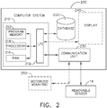
- FIG. 2 illustrates, as a block diagram, a computer system 200 for use in performing part or all of the sensor alignment method 600 described below.
- the computer system 200 is installed within the vehicle 10, while the computer system 200 is communicatively connected to the vehicle 10 in other exemplary embodiments.
- the computer system is configured to receive or collect sensor output from the one or more removable sensors 14 mounted on the vehicle 10 and to generate a representation of the sensor output for use in aligning the one or more removable sensors 14, as described elsewhere herein.
- the computer system 200 includes a controller 210, a database 220, and a communication unit 230.
- the controller includes one or more of each of the following: a program memory 212, a processor 214, and a random access memory (RAM) 216.
- Each program memory 212 is a non-transitory, tangible memory device configured to store electronic data, such as executable instructions for implementing processes, routines, and software programs.
- Each processor 214 is adapted and configured to execute computer-executable instructions, such as software programs, applications, and routines.
- Each RAM 216 is configured as a volatile memory for storing electronic data while in use.
- Each of the program memory 212, processor 214, and RAM 216 is connected to an input/output (I/O) circuit 218, which I/O circuit 218 also connects the controller 210 to the other components of the computer system 200 (i.e., the database 220, the communication unit 230, and any display 240).
- the database 220 is configured to store electronic data in a non-transitory, tangible memory device for use by software applications. In some embodiments, the database 220 and the program memory 212 may be combined into a single memory.
- the communication unit 230 is a component of the computer system 200 configured to manage communication between the controller 210 and external devices that are communicatively connected to the computer system 200, such as the removable sensors 14 and any motorized mountings 250 associated with the removable sensors 14.
- the computer system 200 includes the removable sensors 14 in some embodiments in order to improve control of the electronic data from the removable sensors 14.
- the computer system 200 likewise includes one or more motorized mountings 250 configured to adjust the position and/or orientation of removable sensors 14, as described further below.
- the computer system 200 includes a display 240 configured to present visual representations of sensor output from the removable sensors 14 to a user for verification or further use in aligning the removable sensors 14 of the vehicle 10. Additional or alternative embodiments of the computer system 200 may include fewer, additional, or alternative components, as well as any combination of components illustrated in FIG. 2 .
- FIG. 3 is a perspective view of an example of a removable sensor 14 mounted on a vehicle 10 via a motorized mounting 250.
- the removable sensor 14 is a digital camera mounted to the underside of a wing of an aircraft.
- the motorized mounting 250 is fixedly attached to the vehicle 10 and includes both a motorized translation bed 251 and a motorized gimbal 252, which are electrically controlled by the computer system 200.
- the motorized translation bed 251 translates the lateral position of the removable sensor 14 relative to the local surface of the vehicle 10 to which the motorized mounting 250 is affixed, thereby enabling the position of the removable sensor 14 to be adjusted relative to the center of the vehicle.
- the motorized gimbal 252 rotates the removable sensor 14 in three-dimensional space, thereby enabling the orientation of the removable sensor 14 to be adjusted during alignment.
- the illustrated motorized mounting 250 includes both a motorized translation bed 251 and a motorized gimbal 252, either the motorized translation bed 251 or the motorized gimbal 252 may be installed and used independently ( i.e., without the other component) in various embodiments.
- the removable sensor 14 may be mounted on the vehicle 10 with a mounting that does not include any motorized components, in which case the removable sensor 14 is adjusted manually.
- FIGS. 4 and 5 illustrate the use of spatial templates and representations of sensor output to align a removable sensor 14 mounted on a vehicle 10.
- FIG. 4 is a representation of a spatial template overlaid on an unaligned visual representation 400 of sensor output of a removable sensor 14.
- FIG. 5 is a representation of the same spatial template overlaid on an aligned visual representation 500 of sensor output of the removable sensor 14 that is properly aligned.
- the illustrated unaligned and aligned visual representations 400 and 500 in FIGS. 4 and 5 are presented graphically as two-dimensional images to aid description, it should be understood that such representations may be two-dimensional or three-dimensional images ( e.g. , pixel arrays or voxel point clouds) and need not be actually displayed.
- representations such as the unaligned and aligned visual representations 400 and 500 may be visually presented to a user via the display 240 to facilitate alignment of a removable sensor 14.
- the computer system 200 may internally process corresponding data representations without visually presenting such representations.
- FIG. 4 illustrates the unaligned visual representation 400 of example sensor output of the removable sensor 14, in which the removable sensor 14 is misaligned.
- the unaligned visual representation 400 is an image of the local environment of a vehicle 10, which in this case is an aircraft 18 with a camera mounted on a wing (not shown) of the aircraft 18.
- the local environment of the aircraft 18 in the unaligned visual representation 400 includes portions of the ground and background buildings, as well as a vehicle portion 404.
- a horizon 402 may be determined directly in the representation or indirectly from the alignment of buildings or other features. Such features as the horizon 402 and the vehicle portion 404 may be used as external reference features for sensor alignment, as described further elsewhere herein.
- the spatial template overlays the unaligned visual representation 400 and is visually depicted as a mask having shaded regions representing reference indicators, including a horizon reference indicator 412 and a vehicle reference indicator 414.
- reference indicators including a horizon reference indicator 412 and a vehicle reference indicator 414.
- the horizon reference indicator 412 is misaligned with the horizon 402 (indicating a rotation of the camera from a desired position)
- the vehicle reference indicator 414 is misaligned with the vehicle portion 404 (indicating a rotation or translation of the camera from a desired position).
- FIG. 5 illustrates the aligned visual representation 500 of example sensor output of the removable sensor 14, in which the removable sensor 14 is properly aligned.
- the local environment of the vehicle 10 illustrated in FIG. 5 is substantially similar to that of the local environment illustrated in FIG. 4 , but the removable sensor 14 has been properly aligned.
- the horizon reference indicator 512 aligns with the horizon 502
- the vehicle reference indicator 514 aligns with the vehicle portion 504.
- FIG. 6 is a flow diagram of a sensor alignment method 600 for aligning one or more removable sensors 14 mounted on a vehicle 10.
- the processor 214 of the computer system 200 executes computer-executable instruction stored in the program memory 212 to implement part or all of the sensor alignment method 600.
- the sensor alignment method 600 is implemented to align one or more removable sensors 14 using sensor output from the one or more removable sensors 14.
- the sensor alignment method 600 may be implemented separately for each of a plurality of removable sensors 14 of one or more vehicles 10. Additional, alternative, or fewer aspect may be included in alternative similar methods.
- the sensor alignment method 600 is described herein by reference to the computer system 200 for clarity, other similar computing systems may be used, as will be readily apparent to those of ordinary skill in the art.
- one or more removable sensors 14 are mounted on a vehicle 10.
- the removable sensor 14 mounted on a vehicle 10 via a motorized mounting 250 or via a non-motorized mounting.
- Such removable sensors 14 will not generally be properly aligned when first mounted, so the sensor alignment method 600 aligns the removable sensors 14 to a desired position and orientation to generate useful sensor output.
- the computer system 200 collects sensor output from the one or more removable sensors 14 mounted on the vehicle 10. For each removable sensor 14, the computer system 200 collects sensor output generated by the removable sensor 14 at one or more times.
- the sensor output is generated by the removable sensor 14 as electronic data and transmitted via wired or wireless communication to the computer system 200 through the communication unit 230.
- the sensor output indicates sensed data regarding a portion of the environment of the vehicle 10, as observed from the current position of the removable sensor 14.
- the removable sensor 14 is configured to generate sensor output on an ongoing basis ( e.g. , periodically at constant intervals), in which case either sensor output at a single time or sensor output at a plurality of times may be collected by the computer system 200.
- the sensor output may be a video feed including a plurality of electronic data representing still images at a plurality of times. Because the sensor output is associated with the current position of the removable sensor 14, the sensor output likewise changes as the position ( e.g. , location and/or orientation) of the removable sensor 14 is adjusted.
- the computer system 200 generates one or more representations of the sensor output collected from the one or more removable sensors 14 to facilitate sensor alignment.
- Each representation of the sensor output represents a portion of the current local environment of the vehicle 10 as observed from the current position of a removable sensor 14 at a particular time.
- Such representation may comprise computer-readable data in the program memory 212 (a representation that is not displayed to a user) or may alternatively comprise a visual representation of the sensor data presented to a user via the display 240.
- the representation of the sensor output is generated as a digital image including a portion of the vehicle 10 and a portion of the environment of the vehicle 10 in order to provide external reference features from which to align the removable sensor 14 using a corresponding digital mask, as discussed below.
- representations such as the unaligned visual representation 400 and the aligned visual representation 500 discussed above may be generated by the computer system 200 from the sensor output.
- the computer system 200 generates a representation of the sensor output for each removable sensor 14 at each time in order to facilitate sensor alignment in real-time as the removable sensor 14 is adjusted.
- the computer system 200 compares at least one of the representations of the sensor output against one or more spatial templates.
- the one or more spatial templates are configured to overlay the representations of the sensor output in order to indicate whether the one or more removable sensors 14 are properly aligned in a desired position.
- Each spatial template includes at least one reference indicator to be aligned with an external reference feature in the representation of the sensor output relating to the observed environment of the vehicle 10.
- Each such reference indicator represents an expected position of an external reference feature in the representation of the sensor output when the removable sensor 14 is in a desired position ( i.e., when the removable sensor 14 is properly aligned).
- Such external reference features may be parts of physical objects in the local physical environment of the vehicle 10 (including portions of the vehicle 10 itself or temporary static alignment objects placed within the environment of the vehicle 10) or may be observable aspects of the local physical environment of the vehicle 10 derivable from the sensor output (such as orienting surfaces or lines).
- the one or more reference indicators of the one or more spatial templates include expected spatial positions corresponding to one or more of the following external reference features: one or more portions of the vehicle 10, one or more alignment markings on the surface of the vehicle 10, one or more temporary static alignment objects placed within an environment of the vehicle 10, or a horizon as observed from the position of the removable sensor 14. Use of such external references enables robust performance of the sensor alignment method 600 in many environments.
- the spatial template comprises a digital mask including the one or more reference indicators as one or more shapes within digital mask.
- Such digital mask may include reference indicators relating to portions of the vehicle 10 or other observable aspects of local environment of the vehicle 10, such as the horizon reference indicators 412, 512 and the vehicle reference indicators 414, 514 described above with respect to FIGS. 4 and 5 .
- the digital mask may include one or more reference indicators relating to temporary static alignment objects placed within the local of the vehicle 10 for sensor alignment. For example, temporary static alignment objects (e.g.
- traffic cones, signs, or targets may be placed temporarily at specific positions relative to the vehicle 10 (e.g., at a predetermined distance from the vehicle 10 along a centerline 22 of a taxiway 20) to facilitate alignment of one or more removable sensors 14.
- Such digital masks may simplify comparison by either the computer system 200 or a user via the display 240. Additional or alternative two-dimensional digital masks or three-dimensional digital masks may be used in various embodiments.
- the one or more spatial templates may comprise computer-readable data in the program memory 212 (such as a data template that is not displayed to a user) or may alternatively comprise a visual spatial template (such as a visual mask that is displayed to a user).
- comparing a representation of the sensor output against a spatial template may be performed automatically by the controller 210 of the computer system 200 or may be performed manually by a user of the computer system 200.
- the controller 210 may perform a pixel-wise or bit-wise comparison of one or more portions of the spatial template corresponding to the reference indicators against the corresponding one or more portions of the representation of the sensor output.
- the controller 210 may perform object determination to extract relevant features (e.g. , portions of the vehicle 10, markings, other objects, or a horizon) from the representation of the sensor output and compare the one or more portions of the spatial template corresponding to the reference indicators against such extracted relevant features.
- relevant features e.g. , portions of the vehicle 10, markings, other objects, or a horizon
- the user of the computer system 200 may review the spatial template as an overlay on the representation of the sensor output displayed at the display 240 to identify areas of overlap between the reference indicators in the spatial template and external features in the representation of the sensor output. The user may likewise identify areas without overlap for which overlap is desired, indicating sensor misalignment.
- comparing the one or more spatial templates against the one or more representations of the sensor output may occur prior to performing sensor alignment (i.e., adjusting a current position of a removable sensor 14 or adjusting a representation of the sensor output) or after performing sensor alignment, as described further below.
- comparing the one or more spatial templates against the one or more representations of the sensor output may in some instances occur both prior to performing sensor alignment and after performing such sensor alignment over multiple iterations of such comparisons until the one or more removable sensors 14 are sufficiently aligned.
- the sensor alignment method 600 is made more flexible and more broadly applicable to sensor alignment under various conditions.
- a difference level between the at least one representation of the sensor output and the corresponding one or more spatial templates is determined. In some instances, there may be no difference between the representation of the sensor output and the spatial template against which the representation is compared, in which cases the difference level will be determined as zero difference.
- the difference level represents a level of divergence between one or more portions of the spatial template corresponding to reference indicators and the corresponding one or more portions of the representation of the sensor output corresponding to external references in the environment of the vehicle 10.
- the comparison of representations of sensor output and spatial templates may instead by evaluated using a correspondence level, matching level, or other metrics of either differences or matches between a representation of sensor output and a spatial template in alternative embodiments.
- the difference level may be determined automatically by the controller 210 of the computer system 200 or may be determined manually by a user of the computer system 200.
- the controller 210 may aggregate the differences between the representation of the sensor output and the spatial template across a plurality of bits or pixels.
- the user may estimate the degree of overlap or match between the representation of the sensor output and the spatial template.
- the computer system 200 or a user of the computer system 200 determines whether the one or more removable sensors 14 are properly aligned based upon the difference level determined from the comparison of the at least one representation of sensor output against the one or more spatial templates.
- the computer system 200 is configured to determine the one or more removable sensors 14 are sufficiently properly aligned by determining the difference level determined at block 610 does not exceed a tolerance threshold (indicating that the removable sensor 14 is at a current position that is properly aligned to a desired position) and/or is configured to determine the one or more removable sensors 14 are not sufficiently properly aligned by determining the difference level determined at block 610 does exceed the tolerance threshold (indicating that the removable sensor 14 is at a current position that is not properly aligned to a desired position).
- the user of the computer system 200 determines whether the one or more removable sensors 14 are sufficiently properly aligned by evaluation of the difference level determined at block 610.
- the sensor alignment method 600 may perform multiple iterations at a plurality of times, including a time prior to sensor alignment (i.e., when the difference level exceeds the tolerance threshold) and a time after sensor alignment ( i.e., when the difference level does not exceed the tolerance threshold).
- the sensor alignment method 600 continues to block 620 or terminates.
- the sensor alignment method 600 continues to block 614 or to one of blocks 616 or 618.
- the computer system 200 presents an indication of misalignment of at least one removable sensor 14 to a user via the display 240.
- Such indication of misalignment may include an indication of the difference level to indicate the degree of misalignment.
- the indication of misalignment may include corrective instructions to the user, such as instructions to translate or rotate the position of one or more removable sensors 14.
- the indication of misalignment may include a plurality of options presented to the user via the display 240, such as options to automatically align a removable sensor 14 or to manually align such removable sensor 14.
- the options may include an option to adjust a current position of the removable sensor or to adjust the representation of the sensor output to perform the alignment.
- a use selection of one of such options may determine whether the sensor alignment method 600 proceeds to block 616 or block 618, or whether the sensor alignment method 600 proceeds to manual or automatic alignment.
- the indication of misalignment may indicate one or more of the removable sensors 14 requiring alignment in order to assist the user in performing such alignment.
- the sensor alignment method 600 may implement either an adjustment to a current position of a removable sensor 14 (block 616) on a vehicle 10 or an adjustment to the representation of the sensor output (block 618). In some instances, the sensor alignment method 600 may repeatedly make such adjustments until the removable sensor 14 is properly aligned over a plurality of iterations, and the same type of adjustment need not occur at each iteration. For example, the sensor alignment method 600 may first adjust the current position of the removable sensor 14 during a first iteration, then adjust the representation of the sensor output from the removable sensor 14 during a second iteration at the adjusted current position.
- one or more current positions of the one or more removable sensors 14 mounted on the vehicle 10 are adjusted to improve the alignment of the one or more removable sensors 14.
- Adjusting the current position of a removable sensor 14 may include either or both adjusting a location of the removable sensor 14 on the vehicle 10 or adjusting an orientation of the removable sensor 14 ( e.g., by rotation of the removable sensor 14).
- the current position of each removable sensor 14 is adjusted to position the removable sensor 14 at a desired position on the vehicle 10 based upon the representation of the sensor output and the spatial template, such that one or more external reference features in the representation of the sensor output of the removable sensor 14 at the adjusted current position align with the one or more reference indicators in the spatial template.
- adjusting the current position of a removable sensor 14 includes adjusting an orientation of the removable sensor 14 to align one or more external reference features in a digital image with one or more shapes within a digital mask used as the spatial template.
- Adjusting the current positions of the one or more removable sensors 14 may be performed manually or automatically.
- a user may physically adjust the position of each removable sensor 14 needing adjustment, or the user may control a motorized mounting 250 to adjust the position of the removable sensor 14.
- the controller 210 of the computer system 200 controls the motorized mounting 250 to adjust the position of each removable sensor 14 needing adjustment.
- Controlling the motorized mounting 250 includes generating and communicating from the computer system 200 to the motorized mounting 250 an electrical signal to actuate at least one of the motorized translation bed 251 or the motorized gimbal 252 of the motorized mounting 250 to adjust the current position of the one or more removable sensors 14.
- Such motorized mounting 250 may be used for convenience of the user, for increased efficiency or accuracy, or to facilitate automatic alignment of the removable sensors 14.
- the computer system 200 adjusts the representation of the sensor output of the one or more removable sensors 14 to simulate the removable sensor 14 being positioned at the desired position.
- the representation of the sensor output is aligned without requiring physically adjusting the position of the removable sensor 14, thereby reducing error and cost.
- Such alignment may include any of the following, separately or in any combination: rotating the representation of the sensor output, translating the representation of the sensor output, or scaling the representation of the sensor output.
- adjusting the representation of the sensor output at the current position of the removable sensor 14 includes applying one or more of a translation or a rotation of the representation of the sensor output to align one or more external reference features in a digital image with one or more shapes within a digital mask used as the spatial template.
- adjustments to the representation of the sensor output of the one or more removable sensors 14 may be determined automatically by the controller 210 of the computer system (by identifying the best match between the adjusted representation of the sensor output and the spatial template) or manually by a user (by user input of adjustment instructions to the computer system 200 to obtain alignment between the adjusted representation of the sensor output and the spatial template).
- the sensor alignment method 600 returns to collecting sensor output from the one or more removable sensors 14 at block 604. The sensor alignment method 600 then performs further analysis at block 606-612, as described above. Further adjustments to align the one or more removable sensor 14 may be required, or the removable sensors 14 may be determined to be sufficiently properly aligned at block 612.
- the sensor alignment proceeds, in some embodiments, to block 620.
- the computer system 200 presents an indication of alignment of at least one removable sensor 14 to a user via the display 240 to notify the user that the one or more removable sensors 14 are properly aligned.
- the computer system 200 may determine a removable sensor 14 has been properly aligned and present the indication of alignment to the user as confirmation of such alignment.
- a record of sensor alignment may be stored in the database 220 for future verification. The sensor alignment method 600 then terminates.
Abstract
Systems and methods of aligning removable sensors mounted on a vehicle based upon sensor output of such sensors are described. Sensor output is collected from a removable sensor (e.g., a digital camera), and a representation of such sensor output is generated (e.g., a digital image). The representation of the sensor output is compared against a spatial template (e.g., a digital mask overlaid on the representation) to determine whether external references in the representation align with corresponding reference indicators in the spatial template. When alignment is required, the removable sensor is aligned by one or both of the following until the external references in a representation of sensor data at an updated current location align with the corresponding reference indicators in the spatial template: (i) adjusting the position of the removable sensor on the vehicle or (ii) adjusting the representation of the sensor output to simulate such repositioning.
Description
- This disclosure relates to systems and methods for aligning removable sensors on a vehicle. Computer vision systems are employed on vehicles to monitor the surrounding environment of the vehicle using various sensors and, in some instances, to control vehicle operation using the sensor data from digital cameras, Light Detection and Ranging (LIDAR) units, and similar sensors. Although computer vision techniques offer many benefits, they are sensitive to changes in location or orientation of the sensors. In order to utilize computer vision systems fully, the sensor positions during operation must be comparable to the sensor positions used in training (or other previous use) or model generation. Because sensors are occasionally removed or replaced over the operational life of a vehicle, sensor realignment must occur whenever a sensor is installed or reinstalled on the vehicle. Additionally, sensor location should be consistent across similar vehicles in order to facilitate the generation and use of computer vision systems that may be used on multiple similarly configured vehicles.
- While sensor position is important to computer vision systems, sensor alignment presents particular difficulties. While initial sensor placement in a general area of a vehicle is easily done, such placement in an approximate area of the vehicle is insufficient to obtain the high degree of accuracy needed for optimal computer vision systems. Thus, further alignment of sensors is needed to ensure data accuracy.
- An example includes a method for aligning a removable sensor mounted on a vehicle, comprising: collecting sensor output from the removable sensor at each of a plurality of times, wherein the sensor output at each of the plurality of times is associated with a current position of the removable sensor on the vehicle; generating, by one or more processors, a representation of the sensor output at each of the plurality of times; and/or adjusting (i) the current position of the removable sensor based upon the representation of the sensor output and a spatial template including one or more reference indicators to position the removable sensor at a desired position on the vehicle, in which desired position one or more external reference features in the representation of the sensor output align with the one or more reference indicators in the spatial template, and/or (ii) the representation of the sensor output at the current position of the removable sensor to simulate the removable sensor being positioned at the desired position on the vehicle based upon the spatial template.
- Another example includes a computer system for aligning a removable sensor mounted on a vehicle, including one or more processors communicatively connected to the removable sensor and a program memory communicatively connected to the one or more processors and storing executable instructions that, when executed by the one or more processors, cause the computer system to: collect sensor output from the removable sensor at each of a plurality of times, wherein the sensor output at each of the plurality of times is associated with a current position of the removable sensor on the vehicle; generate a representation of the sensor output at each of the plurality of times; and/or adjust (i) the current position of the removable sensor based upon the representation of the sensor output and a spatial template including one or more reference indicators to position the removable sensor at a desired position on the vehicle, in which desired position one or more external reference features in the representation of the sensor output align with the one or more reference indicators in the spatial template, and/or (ii) the representation of the sensor output at the current position of the removable sensor to simulate the removable sensor being positioned at the desired position on the vehicle based upon the spatial template.
- Yet another example includes a tangible, non-transitory computer-readable medium storing executable instructions for aligning a removable sensor mounted on a vehicle, which executable instructions, when executed by one or more processors of a computer system, cause the computer system to: collect sensor output from the removable sensor at each of a plurality of times, wherein the sensor output at each of the plurality of times is associated with a current position of the removable sensor on the vehicle; generate a representation of the sensor output at each of the plurality of times; and/or determine whether the removable sensor is aligned with a desired position on the vehicle based upon the representation of the sensor output and a spatial template including one or more reference indicators by comparing a portion of the spatial template against a corresponding portion of the representation of the sensor output at a time of the plurality of times, in which desired position one or more external reference features in the representation of the sensor output align with the one or more reference indicators in the spatial template.
- The features, functions, and advantages that have been discussed can be achieved independently in various embodiments or may be combined in yet other embodiments further details of which can be seen with reference to the following description and drawings.
-
-
FIG. 1 is a top view of a vehicle having a plurality of removable sensors; -
FIG. 2 is a block diagram of computer system for aligning removable sensors; -
FIG. 3 is a perspective view of an exemplary removable sensor mounted on a vehicle; -
FIG. 4 is a representation of a spatial template overlaid on a representation of sensor output of a removable sensor that is misaligned; -
FIG. 5 is a representation of the spatial template overlaid on a representation of sensor output of the removable sensor that is properly aligned; and -
FIG. 6 is a flow diagram of an exemplary sensor alignment method. - Disclosed herein are systems, methods, and non-transitory computer-readable media storing instructions for aligning one or more removable sensors on a vehicle, such as digital cameras or LIDAR units on an aircraft. The removable sensors disclosed herein generate sensor output as electronic data regarding the physical local environment around such removable sensors, such as a digital video feed or a three-dimensional spatial map of objects or surfaces in the environment observable by the removable sensors. The following disclosure generally relates to aligning such removable sensors in or on a vehicle using the sensor output to obtain a high degree of accuracy in alignment. The removable sensors may be aligned with previous positions of the same or similar removable sensors, such as when a removable sensor is reinstalled after maintenance or when a new removable sensor is installed to replace a previous removable sensor (e.g., after sensor failure). The removable sensors may likewise be aligned in a corresponding position on multiple vehicles to ensure consistency of sensor position (and thus ensure consistency of sensor data) between multiple vehicles that are similarly configured with removable sensors. Further details regarding such removable sensor alignment are described below.
-
FIG. 1 illustrates a top view of an example of avehicle 10 on whichremovable sensors 14 are mounted. Although thevehicle 10 is illustrated as an aircraft 18 (specifically, as a fixed-wing aircraft), the techniques described herein are applicable to aligning electronic sensors on other types of vehicles (e.g., automobiles, trains, other types of aircraft, ships, trucks, or industrial equipment). Thevehicle 10 is illustrated as being positioned on ataxiway 20 for reference. Thetaxiway 20 has acenterline 22 for use in centering thevehicle 10 while traveling along thetaxiway 20. Thetaxiway 20 also hasedge lines 24 on each side that mark the edge of the usable portion of thetaxiway 20. Thevehicle 10 includeswings 12, which may include a left wing and a right wing. A plurality ofremovable sensors 14 are mounted on thevehicle 10 to capture sensor data forportions 16 of thetaxiway 20 within the respective field of view of eachremovable sensor 14. - Each
removable sensor 14 is an electronic imaging sensor that generates sensor output as electronic data at each of a plurality of times during sensor operation, from which sensor output a two-dimensional or three-dimensional graphical representation of thecorresponding portion 16 of the local environment of thevehicle 10 can be generated. In various embodiments, theremovable sensors 14 discussed throughout this document include one or more digital cameras, LIDAR units, radar units, ultrasonic sensor units, or other electronic devices configured to generate electronic images of portions of a local environment. In further embodiments, theremovable sensors 14 discussed throughout this document include combinations of two or more of the foregoing types ofremovable sensors 14, which combinations improve the robustness of the system by using multiple types of image data. Although illustrated as having tworemovable sensors 14, thevehicle 10 may instead have oneremovable sensor 14 in other configurations, and thevehicle 10 may have more than tworemovable sensors 14 in still other configurations. As illustrated, some embodiments include one or moreremovable sensors 14 mounted on each side (e.g., on each wing 12) of thevehicle 10 to capture sensor data for distinct or partially overlappingportions 16 of the local environment. -
FIG. 2 illustrates, as a block diagram, acomputer system 200 for use in performing part or all of thesensor alignment method 600 described below. In some exemplary embodiments, thecomputer system 200 is installed within thevehicle 10, while thecomputer system 200 is communicatively connected to thevehicle 10 in other exemplary embodiments. The computer system is configured to receive or collect sensor output from the one or moreremovable sensors 14 mounted on thevehicle 10 and to generate a representation of the sensor output for use in aligning the one or moreremovable sensors 14, as described elsewhere herein. Thecomputer system 200 includes acontroller 210, adatabase 220, and acommunication unit 230. - The controller includes one or more of each of the following: a
program memory 212, aprocessor 214, and a random access memory (RAM) 216. Eachprogram memory 212 is a non-transitory, tangible memory device configured to store electronic data, such as executable instructions for implementing processes, routines, and software programs. Eachprocessor 214 is adapted and configured to execute computer-executable instructions, such as software programs, applications, and routines. EachRAM 216 is configured as a volatile memory for storing electronic data while in use. - Each of the
program memory 212,processor 214, andRAM 216 is connected to an input/output (I/O)circuit 218, which I/O circuit 218 also connects thecontroller 210 to the other components of the computer system 200 (i.e., thedatabase 220, thecommunication unit 230, and any display 240). Thedatabase 220 is configured to store electronic data in a non-transitory, tangible memory device for use by software applications. In some embodiments, thedatabase 220 and theprogram memory 212 may be combined into a single memory. Thecommunication unit 230 is a component of thecomputer system 200 configured to manage communication between thecontroller 210 and external devices that are communicatively connected to thecomputer system 200, such as theremovable sensors 14 and anymotorized mountings 250 associated with theremovable sensors 14. - Although illustrated as connected to the
removable sensors 14, thecomputer system 200 includes theremovable sensors 14 in some embodiments in order to improve control of the electronic data from theremovable sensors 14. In additional or alternative embodiments, thecomputer system 200 likewise includes one or moremotorized mountings 250 configured to adjust the position and/or orientation ofremovable sensors 14, as described further below. In further additional or alternative embodiments, thecomputer system 200 includes adisplay 240 configured to present visual representations of sensor output from theremovable sensors 14 to a user for verification or further use in aligning theremovable sensors 14 of thevehicle 10. Additional or alternative embodiments of thecomputer system 200 may include fewer, additional, or alternative components, as well as any combination of components illustrated inFIG. 2 . -
FIG. 3 is a perspective view of an example of aremovable sensor 14 mounted on avehicle 10 via a motorizedmounting 250. In the illustrated example, theremovable sensor 14 is a digital camera mounted to the underside of a wing of an aircraft. In the illustrated example, the motorizedmounting 250 is fixedly attached to thevehicle 10 and includes both amotorized translation bed 251 and a motorizedgimbal 252, which are electrically controlled by thecomputer system 200. Themotorized translation bed 251 translates the lateral position of theremovable sensor 14 relative to the local surface of thevehicle 10 to which the motorizedmounting 250 is affixed, thereby enabling the position of theremovable sensor 14 to be adjusted relative to the center of the vehicle. The motorizedgimbal 252 rotates theremovable sensor 14 in three-dimensional space, thereby enabling the orientation of theremovable sensor 14 to be adjusted during alignment. Although the illustrated motorizedmounting 250 includes both amotorized translation bed 251 and a motorizedgimbal 252, either themotorized translation bed 251 or the motorizedgimbal 252 may be installed and used independently (i.e., without the other component) in various embodiments. In further embodiments, theremovable sensor 14 may be mounted on thevehicle 10 with a mounting that does not include any motorized components, in which case theremovable sensor 14 is adjusted manually. -
FIGS. 4 and5 illustrate the use of spatial templates and representations of sensor output to align aremovable sensor 14 mounted on avehicle 10.FIG. 4 is a representation of a spatial template overlaid on an unalignedvisual representation 400 of sensor output of aremovable sensor 14.FIG. 5 is a representation of the same spatial template overlaid on an alignedvisual representation 500 of sensor output of theremovable sensor 14 that is properly aligned. Although the illustrated unaligned and alignedvisual representations FIGS. 4 and5 are presented graphically as two-dimensional images to aid description, it should be understood that such representations may be two-dimensional or three-dimensional images (e.g., pixel arrays or voxel point clouds) and need not be actually displayed. In some embodiments, representations such as the unaligned and alignedvisual representations display 240 to facilitate alignment of aremovable sensor 14. In other embodiments, thecomputer system 200 may internally process corresponding data representations without visually presenting such representations. -
FIG. 4 illustrates the unalignedvisual representation 400 of example sensor output of theremovable sensor 14, in which theremovable sensor 14 is misaligned. The unalignedvisual representation 400 is an image of the local environment of avehicle 10, which in this case is anaircraft 18 with a camera mounted on a wing (not shown) of theaircraft 18. The local environment of theaircraft 18 in the unalignedvisual representation 400 includes portions of the ground and background buildings, as well as avehicle portion 404. Ahorizon 402 may be determined directly in the representation or indirectly from the alignment of buildings or other features. Such features as thehorizon 402 and thevehicle portion 404 may be used as external reference features for sensor alignment, as described further elsewhere herein. The spatial template overlays the unalignedvisual representation 400 and is visually depicted as a mask having shaded regions representing reference indicators, including ahorizon reference indicator 412 and avehicle reference indicator 414. As can be seen inFIG. 4 , thehorizon reference indicator 412 is misaligned with the horizon 402 (indicating a rotation of the camera from a desired position), and thevehicle reference indicator 414 is misaligned with the vehicle portion 404 (indicating a rotation or translation of the camera from a desired position). -
FIG. 5 illustrates the alignedvisual representation 500 of example sensor output of theremovable sensor 14, in which theremovable sensor 14 is properly aligned. The local environment of thevehicle 10 illustrated inFIG. 5 is substantially similar to that of the local environment illustrated inFIG. 4 , but theremovable sensor 14 has been properly aligned. Thus, thehorizon reference indicator 512 aligns with thehorizon 502, and thevehicle reference indicator 514 aligns with thevehicle portion 504. -
FIG. 6 is a flow diagram of asensor alignment method 600 for aligning one or moreremovable sensors 14 mounted on avehicle 10. In some embodiments, theprocessor 214 of thecomputer system 200 executes computer-executable instruction stored in theprogram memory 212 to implement part or all of thesensor alignment method 600. Thesensor alignment method 600 is implemented to align one or moreremovable sensors 14 using sensor output from the one or moreremovable sensors 14. In some embodiments, thesensor alignment method 600 may be implemented separately for each of a plurality ofremovable sensors 14 of one ormore vehicles 10. Additional, alternative, or fewer aspect may be included in alternative similar methods. Although thesensor alignment method 600 is described herein by reference to thecomputer system 200 for clarity, other similar computing systems may be used, as will be readily apparent to those of ordinary skill in the art. - At
block 602, in some embodiments, one or moreremovable sensors 14 are mounted on avehicle 10. For example, theremovable sensor 14 mounted on avehicle 10 via a motorized mounting 250 or via a non-motorized mounting. Suchremovable sensors 14 will not generally be properly aligned when first mounted, so thesensor alignment method 600 aligns theremovable sensors 14 to a desired position and orientation to generate useful sensor output. - At
block 604, thecomputer system 200 collects sensor output from the one or moreremovable sensors 14 mounted on thevehicle 10. For eachremovable sensor 14, thecomputer system 200 collects sensor output generated by theremovable sensor 14 at one or more times. The sensor output is generated by theremovable sensor 14 as electronic data and transmitted via wired or wireless communication to thecomputer system 200 through thecommunication unit 230. The sensor output indicates sensed data regarding a portion of the environment of thevehicle 10, as observed from the current position of theremovable sensor 14. In some embodiments, theremovable sensor 14 is configured to generate sensor output on an ongoing basis (e.g., periodically at constant intervals), in which case either sensor output at a single time or sensor output at a plurality of times may be collected by thecomputer system 200. For example, the sensor output may be a video feed including a plurality of electronic data representing still images at a plurality of times. Because the sensor output is associated with the current position of theremovable sensor 14, the sensor output likewise changes as the position (e.g., location and/or orientation) of theremovable sensor 14 is adjusted. - At
block 606, thecomputer system 200 generates one or more representations of the sensor output collected from the one or moreremovable sensors 14 to facilitate sensor alignment. Each representation of the sensor output represents a portion of the current local environment of thevehicle 10 as observed from the current position of aremovable sensor 14 at a particular time. Such representation may comprise computer-readable data in the program memory 212 (a representation that is not displayed to a user) or may alternatively comprise a visual representation of the sensor data presented to a user via thedisplay 240. In some embodiments, the representation of the sensor output is generated as a digital image including a portion of thevehicle 10 and a portion of the environment of thevehicle 10 in order to provide external reference features from which to align theremovable sensor 14 using a corresponding digital mask, as discussed below. For example, representations such as the unalignedvisual representation 400 and the alignedvisual representation 500 discussed above may be generated by thecomputer system 200 from the sensor output. In some embodiments, thecomputer system 200 generates a representation of the sensor output for eachremovable sensor 14 at each time in order to facilitate sensor alignment in real-time as theremovable sensor 14 is adjusted. - At
block 608, thecomputer system 200 compares at least one of the representations of the sensor output against one or more spatial templates. The one or more spatial templates are configured to overlay the representations of the sensor output in order to indicate whether the one or moreremovable sensors 14 are properly aligned in a desired position. Each spatial template includes at least one reference indicator to be aligned with an external reference feature in the representation of the sensor output relating to the observed environment of thevehicle 10. Each such reference indicator represents an expected position of an external reference feature in the representation of the sensor output when theremovable sensor 14 is in a desired position (i.e., when theremovable sensor 14 is properly aligned). Such external reference features may be parts of physical objects in the local physical environment of the vehicle 10 (including portions of thevehicle 10 itself or temporary static alignment objects placed within the environment of the vehicle 10) or may be observable aspects of the local physical environment of thevehicle 10 derivable from the sensor output (such as orienting surfaces or lines). In some embodiments, the one or more reference indicators of the one or more spatial templates include expected spatial positions corresponding to one or more of the following external reference features: one or more portions of thevehicle 10, one or more alignment markings on the surface of thevehicle 10, one or more temporary static alignment objects placed within an environment of thevehicle 10, or a horizon as observed from the position of theremovable sensor 14. Use of such external references enables robust performance of thesensor alignment method 600 in many environments. In some embodiments, the spatial template comprises a digital mask including the one or more reference indicators as one or more shapes within digital mask. Such digital mask may include reference indicators relating to portions of thevehicle 10 or other observable aspects of local environment of thevehicle 10, such as thehorizon reference indicators vehicle reference indicators FIGS. 4 and5 . In additional or alternative embodiments, the digital mask may include one or more reference indicators relating to temporary static alignment objects placed within the local of thevehicle 10 for sensor alignment. For example, temporary static alignment objects (e.g., traffic cones, signs, or targets) may be placed temporarily at specific positions relative to the vehicle 10 (e.g., at a predetermined distance from thevehicle 10 along acenterline 22 of a taxiway 20) to facilitate alignment of one or moreremovable sensors 14. Such digital masks may simplify comparison by either thecomputer system 200 or a user via thedisplay 240. Additional or alternative two-dimensional digital masks or three-dimensional digital masks may be used in various embodiments. - As with the one or more representations of the sensor output, the one or more spatial templates may comprise computer-readable data in the program memory 212 (such as a data template that is not displayed to a user) or may alternatively comprise a visual spatial template (such as a visual mask that is displayed to a user). Thus, comparing a representation of the sensor output against a spatial template may be performed automatically by the
controller 210 of thecomputer system 200 or may be performed manually by a user of thecomputer system 200. To compare a representation of the sensor output against a spatial template, thecontroller 210 may perform a pixel-wise or bit-wise comparison of one or more portions of the spatial template corresponding to the reference indicators against the corresponding one or more portions of the representation of the sensor output. Alternatively, thecontroller 210 may perform object determination to extract relevant features (e.g., portions of thevehicle 10, markings, other objects, or a horizon) from the representation of the sensor output and compare the one or more portions of the spatial template corresponding to the reference indicators against such extracted relevant features. To compare a representation of the sensor output against a spatial template, the user of thecomputer system 200 may review the spatial template as an overlay on the representation of the sensor output displayed at thedisplay 240 to identify areas of overlap between the reference indicators in the spatial template and external features in the representation of the sensor output. The user may likewise identify areas without overlap for which overlap is desired, indicating sensor misalignment. - Because the
sensor alignment method 600 may be performed for unaligned sensors in order to align such unaligned sensors and for aligned sensors in order to confirm proper alignment, comparing the one or more spatial templates against the one or more representations of the sensor output may occur prior to performing sensor alignment (i.e., adjusting a current position of aremovable sensor 14 or adjusting a representation of the sensor output) or after performing sensor alignment, as described further below. As can be seen by reference toFIG. 6 , comparing the one or more spatial templates against the one or more representations of the sensor output may in some instances occur both prior to performing sensor alignment and after performing such sensor alignment over multiple iterations of such comparisons until the one or moreremovable sensors 14 are sufficiently aligned. Thus, thesensor alignment method 600 is made more flexible and more broadly applicable to sensor alignment under various conditions. - At
block 610, a difference level between the at least one representation of the sensor output and the corresponding one or more spatial templates is determined. In some instances, there may be no difference between the representation of the sensor output and the spatial template against which the representation is compared, in which cases the difference level will be determined as zero difference. The difference level represents a level of divergence between one or more portions of the spatial template corresponding to reference indicators and the corresponding one or more portions of the representation of the sensor output corresponding to external references in the environment of thevehicle 10. Although described herein as being evaluated based upon a difference level, the comparison of representations of sensor output and spatial templates may instead by evaluated using a correspondence level, matching level, or other metrics of either differences or matches between a representation of sensor output and a spatial template in alternative embodiments. - As above with respect to block 608, the difference level may be determined automatically by the
controller 210 of thecomputer system 200 or may be determined manually by a user of thecomputer system 200. When determined automatically, thecontroller 210 may aggregate the differences between the representation of the sensor output and the spatial template across a plurality of bits or pixels. When determined manually, the user may estimate the degree of overlap or match between the representation of the sensor output and the spatial template. - At
block 612, thecomputer system 200 or a user of thecomputer system 200 determines whether the one or moreremovable sensors 14 are properly aligned based upon the difference level determined from the comparison of the at least one representation of sensor output against the one or more spatial templates. In some embodiments, thecomputer system 200 is configured to determine the one or moreremovable sensors 14 are sufficiently properly aligned by determining the difference level determined atblock 610 does not exceed a tolerance threshold (indicating that theremovable sensor 14 is at a current position that is properly aligned to a desired position) and/or is configured to determine the one or moreremovable sensors 14 are not sufficiently properly aligned by determining the difference level determined atblock 610 does exceed the tolerance threshold (indicating that theremovable sensor 14 is at a current position that is not properly aligned to a desired position). In further embodiments, the user of thecomputer system 200 determines whether the one or moreremovable sensors 14 are sufficiently properly aligned by evaluation of the difference level determined atblock 610. As indicated byFIG. 6 , thesensor alignment method 600 may perform multiple iterations at a plurality of times, including a time prior to sensor alignment (i.e., when the difference level exceeds the tolerance threshold) and a time after sensor alignment (i.e., when the difference level does not exceed the tolerance threshold). When the one or moreremovable sensors 14 are determined to be properly aligned, thesensor alignment method 600 continues to block 620 or terminates. When the one or moreremovable sensors 14 are determined not to be properly aligned, thesensor alignment method 600 continues to block 614 or to one ofblocks - At
block 614, in some embodiments, thecomputer system 200 presents an indication of misalignment of at least oneremovable sensor 14 to a user via thedisplay 240. Such indication of misalignment may include an indication of the difference level to indicate the degree of misalignment. In some embodiments, the indication of misalignment may include corrective instructions to the user, such as instructions to translate or rotate the position of one or moreremovable sensors 14. In further embodiments, the indication of misalignment may include a plurality of options presented to the user via thedisplay 240, such as options to automatically align aremovable sensor 14 or to manually align suchremovable sensor 14. In some such embodiments, the options may include an option to adjust a current position of the removable sensor or to adjust the representation of the sensor output to perform the alignment. A use selection of one of such options may determine whether thesensor alignment method 600 proceeds to block 616 or block 618, or whether thesensor alignment method 600 proceeds to manual or automatic alignment. In embodiments in which thesensor alignment method 600 operates on a plurality ofremovable sensors 14 simultaneously, the indication of misalignment may indicate one or more of theremovable sensors 14 requiring alignment in order to assist the user in performing such alignment. - The
sensor alignment method 600 may implement either an adjustment to a current position of a removable sensor 14 (block 616) on avehicle 10 or an adjustment to the representation of the sensor output (block 618). In some instances, thesensor alignment method 600 may repeatedly make such adjustments until theremovable sensor 14 is properly aligned over a plurality of iterations, and the same type of adjustment need not occur at each iteration. For example, thesensor alignment method 600 may first adjust the current position of theremovable sensor 14 during a first iteration, then adjust the representation of the sensor output from theremovable sensor 14 during a second iteration at the adjusted current position. - At
block 616, one or more current positions of the one or moreremovable sensors 14 mounted on thevehicle 10 are adjusted to improve the alignment of the one or moreremovable sensors 14. Adjusting the current position of aremovable sensor 14 may include either or both adjusting a location of theremovable sensor 14 on thevehicle 10 or adjusting an orientation of the removable sensor 14 (e.g., by rotation of the removable sensor 14). The current position of eachremovable sensor 14 is adjusted to position theremovable sensor 14 at a desired position on thevehicle 10 based upon the representation of the sensor output and the spatial template, such that one or more external reference features in the representation of the sensor output of theremovable sensor 14 at the adjusted current position align with the one or more reference indicators in the spatial template. In some embodiments, adjusting the current position of aremovable sensor 14 includes adjusting an orientation of theremovable sensor 14 to align one or more external reference features in a digital image with one or more shapes within a digital mask used as the spatial template. - Adjusting the current positions of the one or more
removable sensors 14 may be performed manually or automatically. When performed manually, a user may physically adjust the position of eachremovable sensor 14 needing adjustment, or the user may control a motorized mounting 250 to adjust the position of theremovable sensor 14. When performed automatically, thecontroller 210 of thecomputer system 200 controls the motorized mounting 250 to adjust the position of eachremovable sensor 14 needing adjustment. Controlling the motorized mounting 250 includes generating and communicating from thecomputer system 200 to the motorized mounting 250 an electrical signal to actuate at least one of themotorized translation bed 251 or themotorized gimbal 252 of the motorized mounting 250 to adjust the current position of the one or moreremovable sensors 14. Such motorized mounting 250 may be used for convenience of the user, for increased efficiency or accuracy, or to facilitate automatic alignment of theremovable sensors 14. - At
block 618, thecomputer system 200 adjusts the representation of the sensor output of the one or moreremovable sensors 14 to simulate theremovable sensor 14 being positioned at the desired position. Thus, in some embodiments, the representation of the sensor output is aligned without requiring physically adjusting the position of theremovable sensor 14, thereby reducing error and cost. Such alignment may include any of the following, separately or in any combination: rotating the representation of the sensor output, translating the representation of the sensor output, or scaling the representation of the sensor output. In some embodiments, adjusting the representation of the sensor output at the current position of theremovable sensor 14 includes applying one or more of a translation or a rotation of the representation of the sensor output to align one or more external reference features in a digital image with one or more shapes within a digital mask used as the spatial template. In various embodiments, adjustments to the representation of the sensor output of the one or moreremovable sensors 14 may be determined automatically by thecontroller 210 of the computer system (by identifying the best match between the adjusted representation of the sensor output and the spatial template) or manually by a user (by user input of adjustment instructions to thecomputer system 200 to obtain alignment between the adjusted representation of the sensor output and the spatial template). - Following alignment of the one or more
removable sensors 14 by adjustment of current positions of suchremovable sensors 14 or adjustment of representations of sensor output of suchremovable sensor 14, thesensor alignment method 600 returns to collecting sensor output from the one or moreremovable sensors 14 atblock 604. Thesensor alignment method 600 then performs further analysis at block 606-612, as described above. Further adjustments to align the one or moreremovable sensor 14 may be required, or theremovable sensors 14 may be determined to be sufficiently properly aligned atblock 612. - When the
computer system 200 determines that the one or moreremovable sensors 14 are properly aligned atblock 612, the sensor alignment proceeds, in some embodiments, to block 620. Atblock 620, in some embodiments, thecomputer system 200 presents an indication of alignment of at least oneremovable sensor 14 to a user via thedisplay 240 to notify the user that the one or moreremovable sensors 14 are properly aligned. For example, thecomputer system 200 may determine aremovable sensor 14 has been properly aligned and present the indication of alignment to the user as confirmation of such alignment. In some such embodiments, a record of sensor alignment may be stored in thedatabase 220 for future verification. Thesensor alignment method 600 then terminates. - Further, the disclosure comprises examples according to the following clauses:
- Clause 1. A method for aligning a removable sensor mounted on a vehicle, comprising: collecting sensor output from the removable sensor at each of a plurality of times, wherein the sensor output at each of the plurality of times is associated with a current position of the removable sensor on the vehicle; generating, by one or more processors, a representation of the sensor output at each of the plurality of times; and adjusting either (i) the current position of the removable sensor based upon the representation of the sensor output and a spatial template including one or more reference indicators to position the removable sensor at a desired position on the vehicle, in which desired position one or more external reference features in the representation of the sensor output align with the one or more reference indicators in the spatial template, or (ii) the representation of the sensor output at the current position of the removable sensor to simulate the removable sensor being positioned at the desired position on the vehicle based upon the spatial template.
- Clause 2. The method of clause 1, wherein: generating the representation of the sensor output at each of the plurality of times includes generating a digital image including a portion of an environment of the vehicle; and the spatial template comprises a digital mask including the one or more reference indicators as one or more shapes within the digital mask.
- Clause 3. The method of clause 2, comprising adjusting the current position of the removable sensor, wherein adjusting the current position of the removable sensor based upon the representation of the sensor output and the spatial template includes adjusting an orientation of the removable sensor to align the one or more external reference features in the digital image with the one or more shapes within the digital mask.
- Clause 4. The method of clause 2, comprising adjusting the representation of the sensor output at the current position of the removable sensor, wherein adjusting the representation of the sensor output at the current position of the removable sensor includes applying one or more of a translation or a rotation of the representation of the sensor output to align the one or more external reference features in the digital image with the one or more shapes within the digital mask.
- Clause 5. The method of clause 1, wherein the one or more external reference features include a horizon.
- Clause 6. The method of clause 1, wherein the one or more external reference features include one or more of: a portion of the vehicle or alignment markings on a surface of the vehicle.
- Clause 7. The method of clause 1, wherein the one or more external reference features include one or more temporary static alignment objects placed within an environment of the vehicle.
- Clause 8. The method of clause 1, further comprising: comparing, by the one or more processors, a portion of the spatial template against a corresponding portion of the representation of the sensor output at a time of the plurality of times, wherein the time occurs prior to adjusting the current position of the removable sensor or the representation of the sensor output; determining, by the one or more processors, a difference level between the portion of the spatial template and the corresponding portion of the representation of the sensor output; and determining, by the one or more processors, the difference level exceeds a tolerance threshold.
- Clause 9. The method of clause 1, further comprising: comparing, by the one or more processors, a portion of the spatial template against a corresponding portion of the representation of the sensor output at a time of the plurality of times, wherein the time occurs after adjusting the current position of the removable sensor or the representation of the sensor output; determining, by the one or more processors, a difference level between the portion of the spatial template and the corresponding portion of the representation of the sensor output; and determining, by the one or more processors, the difference level does not exceed a tolerance threshold.
-
Clause 10. The method of clause 1, wherein adjusting the position of the removable sensor includes controlling a motorized gimbal to adjust the position of the removable sensor. - Clause 11. A computer system for aligning a removable sensor mounted on a vehicle, comprising: one or more processors communicatively connected to the removable sensor; and a program memory communicatively connected to the one or more processors and storing executable instructions that, when executed by the one or more processors, cause the computer system to: collect sensor output from the removable sensor at each of a plurality of times, wherein the sensor output at each of the plurality of times is associated with a current position of the removable sensor on the vehicle; generate a representation of the sensor output at each of the plurality of times; and adjust either (i) the current position of the removable sensor based upon the representation of the sensor output and a spatial template including one or more reference indicators to position the removable sensor at a desired position on the vehicle, in which desired position one or more external reference features in the representation of the sensor output align with the one or more reference indicators in the spatial template, or (ii) the representation of the sensor output at the current position of the removable sensor to simulate the removable sensor being positioned at the desired position on the vehicle based upon the spatial template.
-
Clause 12. The computer system of clause 11, wherein: the executable instructions that cause the computer system to generate the representation of the sensor output at each of the plurality of times cause the computer system to generate a digital image including a portion of the vehicle and a portion of an environment of the vehicle; and the spatial template comprises a digital mask including the one or more reference indicators as one or more shapes within the digital mask. - Clause 13. The computer system of
clause 12, wherein the executable instructions cause the computer system to adjust the current position of the removable sensor by adjusting an orientation of the removable sensor to align the one or more external reference features in the digital image with the one or more shapes within the digital mask. -
Clause 14. The computer system ofclause 12, the executable instructions cause the computer system to adjust the representation of the sensor output at the current position of the removable sensor by applying one or more of a translation or a rotation of the representation of the sensor output to align the one or more external reference features in the digital image with the one or more shapes within the digital mask. - Clause 15. The computer system of clause 11, further comprising one or more of a motorized gimbal or a motorized translation bed, wherein the executable instructions that cause the computer system to adjust the current position of the removable sensor cause at least one of the motorized gimbal or the motorized translation bed to adjust the current position of the removable sensor.
-
Clause 16. The computer system of clause 11, wherein the vehicle is an aircraft. - Clause 17. A tangible, non-transitory computer-readable medium storing executable instructions for aligning a removable sensor mounted on a vehicle that, when executed by one or more processors of a computer system, cause the computer system to: collect sensor output from the removable sensor at each of a plurality of times, wherein the sensor output at each of the plurality of times is associated with a current position of the removable sensor on the vehicle; generate a representation of the sensor output at each of the plurality of times; and determine whether the removable sensor is aligned with a desired position on the vehicle based upon the representation of the sensor output and a spatial template including one or more reference indicators by comparing a portion of the spatial template against a corresponding portion of the representation of the sensor output at a time of the plurality of times, in which desired position one or more external reference features in the representation of the sensor output align with the one or more reference indicators in the spatial template.
-
Clause 18. The tangible, non-transitory computer-readable medium of clause 17, wherein the executable instructions that cause the computer system to determine whether the removable sensor is aligned with the desired position on the vehicle further cause the computer system to: determine a difference level between the portion of the spatial template and the corresponding portion of the representation of the sensor output; and determine whether the difference level exceeds a tolerance threshold. - Clause 19. The tangible, non-transitory computer-readable medium of
clause 18, wherein the executable instructions further cause the computer system to, when the difference level exceeds the tolerance threshold: adjust the current position of the removable sensor to position the removable sensor at the desired position by adjusting an orientation of the removable sensor to align the one or more external reference features in the representation of the sensor output with the one or more reference indicators in the spatial template. -
Clause 20. The tangible, non-transitory computer-readable medium ofclause 18, wherein the executable instructions further cause the computer system to, when the difference level exceeds the tolerance threshold: adjust the representation of the sensor output at the current position of the removable sensor to simulate the removable sensor being positioned at the desired position on the vehicle based upon the spatial template by applying one or more of a translation or a rotation of the representation of the sensor output to align the one or more external reference features in the representation of the sensor output with the one or more reference indicators in the spatial template. - Clause 21. The tangible, non-transitory computer-readable medium of
clause 18, wherein the executable instructions further cause the computer system to, when the difference level does not exceed the tolerance threshold: present an indication of alignment to a user of the computer system via a display. - While various embodiments have been described above, this disclosure is not intended to be limited thereto. Variations can be made to the disclosed embodiments that are still within the scope of the appended claims.
Claims (15)
- A method for aligning a removable sensor (14) mounted on a vehicle (10), comprising:collecting (604) sensor output from the removable sensor (14) at each of a plurality of times, wherein the sensor output at each of the plurality of times is associated with a current position of the removable sensor (14) on the vehicle (10);generating (606), by one or more processors (214), a representation of the sensor output at each of the plurality of times; andadjusting (616, 618) either (i) the current position of the removable sensor (14) based upon the representation of the sensor output and a spatial template including one or more reference indicators to position the removable sensor (14) at a desired position on the vehicle (10), in which desired position one or more external reference features in the representation of the sensor output align with the one or more reference indicators in the spatial template, or (ii) the representation of the sensor output at the current position of the removable sensor (14) to simulate the removable sensor (14) being positioned at the desired position on the vehicle (10) based upon the spatial template.
- The method of claim 1, wherein:generating (606) the representation of the sensor output at each of the plurality of times includes generating a digital image (400, 500) including a portion of an environment of the vehicle (10); andthe spatial template comprises a digital mask including the one or more reference indicators (412, 414, 512, 514) as one or more shapes within the digital mask.
- The method of claim 2, comprising adjusting (616) the current position of the removable sensor (14), wherein adjusting the current position of the removable sensor (14) based upon the representation of the sensor output and the spatial template includes adjusting an orientation of the removable sensor (14) to align the one or more external reference features in the digital image with the one or more shapes within the digital mask.
- The method of claim 2, comprising adjusting (618) the representation of the sensor output at the current position of the removable sensor (14), wherein adjusting the representation of the sensor output at the current position of the removable sensor (14) includes applying one or more of a translation or a rotation of the representation of the sensor output to align the one or more external reference features in the digital image with the one or more shapes within the digital mask.
- The method of claim 1, wherein the one or more external reference features include a horizon (402, 502).
- The method of claim 1, wherein the one or more external reference features include one or more of: a portion (404, 504) of the vehicle (10) or alignment markings on a surface of the vehicle (10).
- The method of claim 1, wherein the one or more external reference features include one or more temporary static alignment objects placed within an environment of the vehicle (10).
- The method of claim 1, further comprising:comparing (608), by the one or more processors (214), a portion of the spatial template against a corresponding portion of the representation of the sensor output at a time of the plurality of times, wherein the time occurs prior to adjusting the current position of the removable sensor (14) or the representation of the sensor output;determining (610), by the one or more processors (214), a difference level between the portion of the spatial template and the corresponding portion of the representation of the sensor output; anddetermining (612), by the one or more processors (214), the difference level exceeds a tolerance threshold.
- The method of claim 1, further comprising:comparing (608), by the one or more processors (214), a portion of the spatial template against a corresponding portion of the representation of the sensor output at a time of the plurality of times, wherein the time occurs after adjusting the current position of the removable sensor (14) or the representation of the sensor output;determining (610), by the one or more processors (214), a difference level between the portion of the spatial template and the corresponding portion of the representation of the sensor output; anddetermining (612), by the one or more processors (214), the difference level does not exceed a tolerance threshold.
- The method of claim 1, wherein adjusting (616) the position of the removable sensor (14) includes controlling a motorized gimbal (252) to adjust the position of the removable sensor (14).
- A computer system (200) for aligning a removable sensor (14) mounted on a vehicle (10), comprising:one or more processors (214) communicatively connected to the removable sensor (14); anda program memory (212) communicatively connected to the one or more processors (214) and storing executable instructions that, when executed by the one or more processors (214), cause the computer system (200) to:collect (604) sensor output from the removable sensor (14) at each of a plurality of times, wherein the sensor output at each of the plurality of times is associated with a current position of the removable sensor (14) on the vehicle (10);generate (606) a representation of the sensor output at each of the plurality of times; andadjust (616, 618) either (i) the current position of the removable sensor (14) based upon the representation of the sensor output and a spatial template including one or more reference indicators to position the removable sensor (14) at a desired position on the vehicle (10), in which desired position one or more external reference features in the representation of the sensor output align with the one or more reference indicators in the spatial template, or (ii) the representation of the sensor output at the current position of the removable sensor (14) to simulate the removable sensor (14) being positioned at the desired position on the vehicle (10) based upon the spatial template.
- The computer system (200) of claim 11, wherein:the executable instructions that cause the computer system (200) to generate (606) the representation of the sensor output at each of the plurality of times cause the computer system (200) to generate a digital image (400, 500) including a portion of the vehicle (10) and a portion of an environment of the vehicle (10); andthe spatial template comprises a digital mask including the one or more reference indicators (412, 414, 512, 514) as one or more shapes within the digital mask.
- The computer system (200) of claim 12, wherein the executable instructions at least one of:cause the computer system (200) to adjust (616) the current position of the removable sensor (14) by adjusting an orientation of the removable sensor (14) to align the one or more external reference features in the digital image with the one or more shapes within the digital mask; andcause the computer system (200) to adjust (618) the representation of the sensor output at the current position of the removable sensor (14) by applying one or more of a translation or a rotation of the representation of the sensor output to align the one or more external reference features in the digital image with the one or more shapes within the digital mask.
- The computer system (200) of claim 11, further comprising one or more of a motorized gimbal (252) or a motorized translation bed (251), wherein the executable instructions that cause the computer system (200) to adjust the current position of the removable sensor (14) cause at least one of the motorized gimbal (252) or the motorized translation bed (251) to adjust the current position of the removable sensor (14).
- The computer system (200) of claim 11, wherein the vehicle (10) is an aircraft (18).
Applications Claiming Priority (2)
| Application Number | Priority Date | Filing Date | Title |
|---|---|---|---|
| US16/393,376 US11639234B2 (en) | 2019-04-24 | 2019-04-24 | Method, system and apparatus for aligning a removable sensor on a vehicle |
| US16/393,388 US20200341128A1 (en) | 2019-04-24 | 2019-04-24 | Aligning sensors on vehicles using sensor output |
Publications (1)
| Publication Number | Publication Date |
|---|---|
| EP3731188A1 true EP3731188A1 (en) | 2020-10-28 |
Family
ID=72266046
Family Applications (2)
| Application Number | Title | Priority Date | Filing Date |
|---|---|---|---|
| EP20166586.6A Pending EP3730969A1 (en) | 2019-04-24 | 2020-03-30 | Method, system and apparatus for aligning a removable sensor on a vehicle |
| EP20166580.9A Withdrawn EP3731188A1 (en) | 2019-04-24 | 2020-03-30 | Aligning sensors on vehicles using sensor output |
Family Applications Before (1)
| Application Number | Title | Priority Date | Filing Date |
|---|---|---|---|
| EP20166586.6A Pending EP3730969A1 (en) | 2019-04-24 | 2020-03-30 | Method, system and apparatus for aligning a removable sensor on a vehicle |
Country Status (3)
| Country | Link |
|---|---|
| EP (2) | EP3730969A1 (en) |
| CN (2) | CN111856427A (en) |
| CA (2) | CA3076342A1 (en) |
Cited By (1)
| Publication number | Priority date | Publication date | Assignee | Title |
|---|---|---|---|---|
| WO2021089561A1 (en) * | 2019-11-04 | 2021-05-14 | Evitado Technologies GmbH | Portable sensor system |
Citations (7)
| Publication number | Priority date | Publication date | Assignee | Title |
|---|---|---|---|---|
| US20080186384A1 (en) * | 2007-02-01 | 2008-08-07 | Sanyo Electric Co., Ltd. | Apparatus and method for camera calibration, and vehicle |
| US8259174B2 (en) * | 2009-02-06 | 2012-09-04 | GM Global Technology Operations LLC | Camera auto-calibration by horizon estimation |
| DE102013021616A1 (en) * | 2013-12-19 | 2015-06-25 | Audi Ag | Motor vehicle and method for checking a calibration of a camera |
| US20170103546A1 (en) * | 2014-04-16 | 2017-04-13 | Denso Corporation | Installation error display control apparatus and installation error detection apparatus of onboard camera |
| WO2018000037A1 (en) * | 2016-06-29 | 2018-01-04 | Seeing Machines Limited | Systems and methods for identifying pose of cameras in a scene |
| US10054843B2 (en) * | 2015-08-14 | 2018-08-21 | Sz Dji Osmo Technology Co., Ltd. | Gimbal having parallel stability mechanism |
| US20180342082A1 (en) * | 2017-05-25 | 2018-11-29 | GM Global Technology Operations LLC | Method and apparatus for camera calibration |
Family Cites Families (10)
| Publication number | Priority date | Publication date | Assignee | Title |
|---|---|---|---|---|
| US5266955A (en) * | 1991-07-08 | 1993-11-30 | Kansei Corporation | Laser-radar type distance measuring equipment |
| JP3462740B2 (en) * | 1998-01-06 | 2003-11-05 | 株式会社日立製作所 | Axis adjustment method for automotive radar |
| DE19852101C2 (en) * | 1998-11-12 | 2001-05-23 | Mannesmann Vdo Ag | Method and device for adjusting a beam path of a beam-emitting sensor |
| DE19907592A1 (en) * | 1999-02-22 | 2000-08-24 | Volkswagen Ag | Device and method for adjusting a distance measuring device |
| DE19957186A1 (en) * | 1999-11-27 | 2001-05-31 | Volkswagen Ag | Method for adjusting a distance and direction sensor of a vehicle |
| EP1340998A1 (en) * | 2002-02-28 | 2003-09-03 | Alignment International Limited | Apparatus and method for identifying the orientation of an object |
| EP2113787B1 (en) * | 2008-05-02 | 2014-06-25 | Harro Koch | Device for monitoring the alignment of radar sensors |
| ES2529604B1 (en) * | 2013-07-22 | 2015-12-02 | Universitat Politècnica De Catalunya | STABILIZATION SYSTEM FOR THE COMPENSATION OF ANGULAR MOVEMENT IN MOBILE LIDAR PLATFORMS |
| DE202015106939U1 (en) * | 2015-07-29 | 2016-04-06 | Hella Gutmann Solutions GmbH | Device for calibrating at least one radar sensor |
| DE102016206516A1 (en) * | 2016-04-19 | 2017-10-19 | Robert Bosch Gmbh | Adjustment system for aligning an object detection sensor on a vehicle |
-
2020
- 2020-03-19 CA CA3076342A patent/CA3076342A1/en active Pending
- 2020-03-30 EP EP20166586.6A patent/EP3730969A1/en active Pending
- 2020-03-30 EP EP20166580.9A patent/EP3731188A1/en not_active Withdrawn
- 2020-03-30 CA CA3077438A patent/CA3077438A1/en active Pending
- 2020-04-21 CN CN202010316047.4A patent/CN111856427A/en active Pending
- 2020-04-22 CN CN202010321991.9A patent/CN111856435A/en active Pending
Patent Citations (7)
| Publication number | Priority date | Publication date | Assignee | Title |
|---|---|---|---|---|
| US20080186384A1 (en) * | 2007-02-01 | 2008-08-07 | Sanyo Electric Co., Ltd. | Apparatus and method for camera calibration, and vehicle |
| US8259174B2 (en) * | 2009-02-06 | 2012-09-04 | GM Global Technology Operations LLC | Camera auto-calibration by horizon estimation |
| DE102013021616A1 (en) * | 2013-12-19 | 2015-06-25 | Audi Ag | Motor vehicle and method for checking a calibration of a camera |
| US20170103546A1 (en) * | 2014-04-16 | 2017-04-13 | Denso Corporation | Installation error display control apparatus and installation error detection apparatus of onboard camera |
| US10054843B2 (en) * | 2015-08-14 | 2018-08-21 | Sz Dji Osmo Technology Co., Ltd. | Gimbal having parallel stability mechanism |
| WO2018000037A1 (en) * | 2016-06-29 | 2018-01-04 | Seeing Machines Limited | Systems and methods for identifying pose of cameras in a scene |
| US20180342082A1 (en) * | 2017-05-25 | 2018-11-29 | GM Global Technology Operations LLC | Method and apparatus for camera calibration |
Cited By (1)
| Publication number | Priority date | Publication date | Assignee | Title |
|---|---|---|---|---|
| WO2021089561A1 (en) * | 2019-11-04 | 2021-05-14 | Evitado Technologies GmbH | Portable sensor system |
Also Published As
| Publication number | Publication date |
|---|---|
| CN111856435A (en) | 2020-10-30 |
| CN111856427A (en) | 2020-10-30 |
| EP3730969A1 (en) | 2020-10-28 |
| CA3077438A1 (en) | 2020-10-24 |
| CA3076342A1 (en) | 2020-10-24 |
Similar Documents
| Publication | Publication Date | Title |
|---|---|---|
| EP3607272B1 (en) | Automated image labeling for vehicle based on maps | |
| CN205024577U (en) | Self -walking -type building machine | |
| CN109690623B (en) | System and method for recognizing pose of camera in scene | |
| JP6918672B2 (en) | Deterioration diagnosis system | |
| CN1788188B (en) | Picked-up image display method and device | |
| CN105302151A (en) | Aircraft docking guidance and type recognition system and method | |
| CN112102646B (en) | Parking lot entrance positioning method and device in parking positioning and vehicle-mounted terminal | |
| CN110610518B (en) | Target pose measurement system and method based on feature point position correction | |
| KR20190132404A (en) | Direct vehicle detection as 3D bounding boxes using neural network image processing | |
| US20150149000A1 (en) | Unkown | |
| CN112307810B (en) | Visual positioning effect self-checking method and vehicle-mounted terminal | |
| CN109685858A (en) | A kind of monocular cam online calibration method | |
| RU2753004C2 (en) | System and method for positioning and controlling the aircraft as it moves along the taxiway | |
| CN205024576U (en) | Self -walking -type building machine | |
| CN111141311B (en) | Evaluation method and system of high-precision map positioning module | |
| JP2021512242A (en) | How to command a set of intervention tools attached to a railroad intervention vehicle | |
| EP3731188A1 (en) | Aligning sensors on vehicles using sensor output | |
| CN111105466B (en) | Calibration method of camera in CT system | |
| JP7161304B2 (en) | localization system | |
| US20200341128A1 (en) | Aligning sensors on vehicles using sensor output | |
| CN106840137B (en) | Automatic positioning and orienting method of four-point type heading machine | |
| CN104858877B (en) | High-tension line drop switch changes the control method of control system automatically | |
| EP4068041B1 (en) | System and method for visual aided landing | |
| CN115389516A (en) | Pavement disease de-weighting method based on high-precision positioning and deep neural network | |
| CN113643374A (en) | Multi-view camera calibration method, device, equipment and medium based on road characteristics |
Legal Events
| Date | Code | Title | Description |
|---|---|---|---|
| PUAI | Public reference made under article 153(3) epc to a published international application that has entered the european phase |
Free format text: ORIGINAL CODE: 0009012 |
|
| STAA | Information on the status of an ep patent application or granted ep patent |
Free format text: STATUS: THE APPLICATION HAS BEEN PUBLISHED |
|
| AK | Designated contracting states |
Kind code of ref document: A1 Designated state(s): AL AT BE BG CH CY CZ DE DK EE ES FI FR GB GR HR HU IE IS IT LI LT LU LV MC MK MT NL NO PL PT RO RS SE SI SK SM TR |
|
| AX | Request for extension of the european patent |
Extension state: BA ME |
|
| STAA | Information on the status of an ep patent application or granted ep patent |
Free format text: STATUS: THE APPLICATION IS DEEMED TO BE WITHDRAWN |
|
| 18D | Application deemed to be withdrawn |
Effective date: 20210429 |