EP3731181A1 - Method and apparatus for point cloud registration, server and computer readable medium - Google Patents
Method and apparatus for point cloud registration, server and computer readable medium Download PDFInfo
- Publication number
- EP3731181A1 EP3731181A1 EP20161347.8A EP20161347A EP3731181A1 EP 3731181 A1 EP3731181 A1 EP 3731181A1 EP 20161347 A EP20161347 A EP 20161347A EP 3731181 A1 EP3731181 A1 EP 3731181A1
- Authority
- EP
- European Patent Office
- Prior art keywords
- point cloud
- grid
- matched
- similarity
- current
- Prior art date
- Legal status (The legal status is an assumption and is not a legal conclusion. Google has not performed a legal analysis and makes no representation as to the accuracy of the status listed.)
- Withdrawn
Links
Images


Classifications
-
- G—PHYSICS
- G06—COMPUTING OR CALCULATING; COUNTING
- G06T—IMAGE DATA PROCESSING OR GENERATION, IN GENERAL
- G06T7/00—Image analysis
- G06T7/30—Determination of transform parameters for the alignment of images, i.e. image registration
-
- G—PHYSICS
- G06—COMPUTING OR CALCULATING; COUNTING
- G06T—IMAGE DATA PROCESSING OR GENERATION, IN GENERAL
- G06T7/00—Image analysis
- G06T7/30—Determination of transform parameters for the alignment of images, i.e. image registration
- G06T7/33—Determination of transform parameters for the alignment of images, i.e. image registration using feature-based methods
- G06T7/337—Determination of transform parameters for the alignment of images, i.e. image registration using feature-based methods involving reference images or patches
-
- G—PHYSICS
- G06—COMPUTING OR CALCULATING; COUNTING
- G06T—IMAGE DATA PROCESSING OR GENERATION, IN GENERAL
- G06T7/00—Image analysis
- G06T7/30—Determination of transform parameters for the alignment of images, i.e. image registration
- G06T7/33—Determination of transform parameters for the alignment of images, i.e. image registration using feature-based methods
-
- G—PHYSICS
- G06—COMPUTING OR CALCULATING; COUNTING
- G06T—IMAGE DATA PROCESSING OR GENERATION, IN GENERAL
- G06T2207/00—Indexing scheme for image analysis or image enhancement
- G06T2207/10—Image acquisition modality
- G06T2207/10028—Range image; Depth image; 3D point clouds
-
- G—PHYSICS
- G06—COMPUTING OR CALCULATING; COUNTING
- G06T—IMAGE DATA PROCESSING OR GENERATION, IN GENERAL
- G06T2207/00—Indexing scheme for image analysis or image enhancement
- G06T2207/20—Special algorithmic details
- G06T2207/20016—Hierarchical, coarse-to-fine, multiscale or multiresolution image processing; Pyramid transform
-
- G—PHYSICS
- G06—COMPUTING OR CALCULATING; COUNTING
- G06T—IMAGE DATA PROCESSING OR GENERATION, IN GENERAL
- G06T2207/00—Indexing scheme for image analysis or image enhancement
- G06T2207/30—Subject of image; Context of image processing
- G06T2207/30248—Vehicle exterior or interior
-
- G—PHYSICS
- G06—COMPUTING OR CALCULATING; COUNTING
- G06T—IMAGE DATA PROCESSING OR GENERATION, IN GENERAL
- G06T2207/00—Indexing scheme for image analysis or image enhancement
- G06T2207/30—Subject of image; Context of image processing
- G06T2207/30248—Vehicle exterior or interior
- G06T2207/30252—Vehicle exterior; Vicinity of vehicle
Definitions
- the present disclosure relates to a field of unmanned vehicle technologies, and more particularly to a method and an apparatus for point cloud registration, a server and a computer readable medium.
- Point cloud registration refers to merging two pieces of point clouds describing a same scene into one piece of point cloud data without ghosting and offset through rotation and translation.
- the point cloud registration is essential in a high-precision map.
- the point cloud registration is also widely used in a scene such as a 3D (three-dimensional) modeling, 3D reconstruction.
- main methods for point cloud registration include the following.
- the present disclosure provides a method and an apparatus for point cloud registration, a server and a computer readable medium.
- embodiments of the present disclosure provide a method for point cloud registration.
- the method includes: segmenting a source point cloud into different categories of attribute features based on semantic, and segmenting a destination point cloud into different categories of the attribute features based on semantic, the attribute features including a ground feature and a non-ground feature; segmenting the source point cloud and the destination point cloud into a plurality of grids based on the attribute features; calculating a current similarity between the source point cloud and the destination point cloud based on the plurality of grids; determining whether the current similarity and a current iterative number satisfy a preset condition; in response to determining that the current similarity and the current iterative number satisfy the preset condition, performing a registration on the source point cloud and the destination point cloud to obtain a registered result; and based on the registered result, adjusting a position of the source point cloud, updating the current iterative number, and calculating an updated similarity between the destination point cloud and the source point cloud after adjusting the position.
- determining whether the current similarity and the current iterative number satisfy the preset condition includes: comparing the current similarity with a first preset threshold, and comparing the current iterative number with a second preset threshold; and comparing the current similarity with a previously calculated similarity when the current similarity is smaller than or equal to the first threshold, and the current iterative number is smaller than the second threshold.
- the preset condition includes: the current similarity being greater than the previously calculated similarity.
- the method further includes: when the current similarity is smaller than or equal to the previously calculated similarity, setting back the position of the source point cloud, and performing the registration on the source point cloud and the destination point cloud.
- the method further includes: when the current similarity is greater than the first threshold, or the current iterative number is greater than or equal to the second threshold, decreasing a grid size of each of the plurality of grids according to a preset convergence step size; determining whether the grid size decreased is greater than a third preset threshold; in response to determining that the grid size decreased is greater than the third preset threshold, based on the grid size decreased, segmenting the source point cloud and the destination point cloud into a plurality of grids according to the attribute features.
- calculating the current similarity between the source point cloud and the destination point cloud based on the plurality of grids includes: calculating the current similarity between the source point cloud and the destination point cloud based on the attribute features of the plurality of grids.
- calculating the current similarity between the source point cloud and the destination point cloud based on the attribute features of the plurality of grids includes: for each grid in the source point cloud, selecting a grid closest the grid in the source point cloud from the destination point cloud; and calculating the current similarity between the source point cloud and the destination point cloud according to an attribute feature of each grid in the source point cloud.
- performing the registration on the source point cloud and the destination point cloud to obtain the registered result includes: selecting a first grid to be matched from the source point cloud based on the attribute features; determining a second grid to be matched from the destination point cloud according to an attribute feature of the first grid to be matched; and matching the first grid to be matched with the second grid to be matched.
- determining the second grid to be matched in the destination point cloud according to the attribute feature of the first grid to be matched includes: when the first grid to be matched includes the ground feature only, selecting grids from the destination point cloud, a distance between each grid selected and the first grid to be matched being smaller than a preset fourth threshold value, calculating a matching degree between each grid selected and the first grid to be matched, and selecting a grid with the highest matching degree as the second grid to be matched; and when the first grid to be matched includes the non-ground feature only, or the first grid to be matched includes the ground feature and the non-ground feature, selecting grids from the destination point cloud, an attribute feature of each grid selected being the same as the attribute feature of the first gird to be matched, and a distance between the grid selected and the first grid to be matched being smaller than the fourth preset threshold, calculating a matching degree between each grid selected and the first grid to be matched, and selecting a grid with the highest matching degree as the second grid to be matched.
- h s represents an average height of respective ground features in the first grid to be matched in the source point cloud
- h d represents an average height of respective ground features in a set of grids in the destination point cloud, in which a distance between each of the set of grids and the first grid to be registered is smaller than the fourth preset threshold
- ⁇ h thr represents a preset value
- S f e ⁇ x s ⁇ ⁇ x d ⁇ 2 ⁇ x thr 2 ⁇ y s ⁇ ⁇ y d ⁇ 2 ⁇ y thr 2 ⁇ h s ⁇ ⁇ h d
- the registered result includes: a displacement to be moved; and matching the first grid to be matched with the second grid to be matched includes: calculating a relative position between the second grid to be matched and the first grid to be matched; and calculating the displacement to be moved of the source point cloud according to the relative position, a matching degree corresponding to the second grid to be matched and a residual error equation.
- inventions of the present disclosure further provide an apparatus for point cloud registration.
- the apparatus includes: a semantic segmentation module, a rasterizing module, a similarity calculating module, a determining module, a registration module, and a position updating module.
- the semantic segmentation module is configured to segment a source point cloud into different categories of attribute features based on semantic, and to segment a destination point cloud into different categories of the attribute features based on semantic, the attribute features including a ground feature and a non-ground feature.
- the rasterizing module is configured to segment the source point cloud and the destination point cloud into a plurality of grids based on the attribute features.
- the similarity calculating module is configured to calculate a current similarity between the source point cloud and the destination point cloud based on the plurality of grids.
- the determining module is configured to determine whether the current similarity and a current iterative number satisfy a preset condition.
- the registration module is configured to perform a registration on the source point cloud and the destination point cloud to obtain a registered result in response to determining that the current similarity and the current iterative number satisfy the preset condition.
- the position updating module is configured to, based on the registered result, adjust a position of the source point cloud, update the current iterative number, and calculate an updated similarity between the destination point cloud and the source point cloud after adjusting the position.
- the determining module is configured to compare the current similarity with a first preset threshold, and to compare the current iterative number with a second preset threshold; and to compare the current similarity with a previously calculated similarity when current similarity is smaller than or equal to the first threshold, and the current iterative number is smaller than the second threshold; and the preset condition includes: the current similarity being greater than the previously calculated similarity.
- the apparatus further includes a rollback module.
- the rollback module is configured to set back the position of the source point cloud when the determining module determines that the current similarity is smaller than or equal to the previously calculated similarity.
- the registration module is configured to register the source point cloud and the destination point cloud after the rollback module sets back the position of the source point cloud.
- the present disclosure further provides a server.
- the server includes one or more processors; and a storage device having one or more programs stored thereon.
- the one or more processors are caused to implement the method for point cloud registration described above.
- the present disclosure further provides a computer readable medium having a computer program stored thereon.
- the method for point cloud registration described above is implemented when being executed by the computer program.
- semantic segmentation and rasterization are combined to be performed on the point cloud, more abundant feature information except the height and the reflectivity in the point cloud is provided due to diversity of the attribute features of the point cloud, and different registration solution may be employed for different attribute features, thereby improving the matching accuracy.
- taking the attribute feature as the basis of registration may also improve the matching accuracy for some strong feature scenes with less point cloud data.
- semantic segmentation may also remove noise matching the interference from the vehicle, the pedestrian and the like, further improving the matching accuracy. For a scene with a large error (larger than 5m) of collected data, the effect of point cloud registration is particularly obvious by employing the solution of embodiments of the present disclosure.
- an average recall rate of point clouds based on semantic segmentation is about 95%.
- the present disclosure provides a method for point cloud registration in combination with a method for performing semantic segmentation on a point cloud and a method for performing rasterization on the point cloud, and pointedly provides a matching strategy and a similarity evaluation strategy.
- An embodiment of the present disclosure provides a method for point cloud registration. Detailed description will be made below to the method for the point cloud registration with reference to FIG. 1 . As illustrated in FIG. 1 , the method includes the following.
- a source point cloud is segmented into different categories of attribute features based on semantic
- a destination point cloud is segmented into different categories of the attribute features based on semantic.
- the attribute features include a ground feature and a non-ground feature.
- Categories of the ground feature may include ground, a lane line, etc..
- Categories of the non-ground feature may include a guardrail, a curb, a signpost, a rod-shaped object, a viaduct, etc.
- the source point cloud and the destination point cloud are segmented into a plurality of grids based on the attribute features.
- a specified grid size is 60m ⁇ 60m.
- the point cloud may include noise interference from a car, a pedestrian and the like. Therefore, in order to ensure the accuracy for point cloud registration, a point cloud of the noise may not be placed in the grid during performing the rasterization on the point cloud.
- Each grid may include one or more attribute features (i.e., a box).
- attribute features i.e., a box
- a size of the attribute feature corresponding to the points is subject to the actual area, and the value of box_info needs to be modified accordingly.
- one grid includes three categories of attribute features, such as a guardrail, a ground and a light pole, and the size of the grid is 3m ⁇ 3m, the guardrail is taken as a box, the ground is taken as a box, and the light pole is taken as a box.
- an area of points of the light pole in the point cloud is 0.5m ⁇ 0.5m
- an area of points of the ground in the point cloud is 3m ⁇ 3m
- an area of points of the guardrail in the point cloud is 3m ⁇ 0.5m
- the size of the box of the light pole and the size of the box of the guardrail are adjusted to the actual size.
- the actions at this block are to perform rasterization on the point cloud.
- the detailed implementation for performing the rasterization on the point cloud is the same as that in the related art, which is not elaborated herein.
- a current similarity between the source point cloud and the destination point cloud is calculated based on the plurality of grids.
- the current similarity between the source point cloud and the destination point cloud may be calculated based on attribute features of the plurality of grids.
- a procedure for calculating the current similarity between the source point cloud and the destination point cloud will be described with reference to FIG. 5 .
- a current relative position of the source point cloud and the destination point cloud meets a requirement.
- An operation for the point cloud registration may further be proceeded (that is, executing actions at block S15 and subsequent actions).
- a registration is performed on the source point cloud and the destination point cloud to obtain a registered result.
- the registered result includes a displacement to be moved.
- the displacement to be moved of the source point cloud may be calculated through the actions at the block.
- a position of the source point cloud is adjusted, and the current iterative number is updated.
- the position of the source point cloud is moved according to the displacement to be moved, the current iteration is end, and 1 is added to the current iterative number.
- the iteration procedure may be optimized, and the calculation efficiency and the accuracy are also improved.
- the upper limitation of the iterative number may be set to 50.
- the procedure for the point cloud registration is the iteration procedure.
- the actions at this block are completed, and the iteration procedure is completed for one time.
- the actions for calculating the current similarity between the definition point cloud and the source point cloud after moving the position are executed again, the actions for determining whether the current similarity and the current iterative number satisfy the preset condition are executed again, and the actions for a next iteration are executed.
- semantic segmentation and rasterization are combined to be performed on the point cloud, more abundant feature information except the height and the reflectivity in the point cloud is provided due to diversity of the attribute features of the point cloud, and different registration solution may be employed for different attribute features, thereby improving the matching accuracy.
- taking the attribute feature as the basis of registration may also improve the matching accuracy for some strong feature scenes with less point cloud data.
- semantic segmentation may also remove noise matching the interference from the vehicle, the pedestrian and the like, further improving the matching accuracy. For a scene with a large error (greater than 5m) of collected data, the effect of the point cloud registration is particularly obvious by employing the solution of embodiments of the present disclosure.
- the procedure for determining whether the current similarity and the current iterative number satisfy the preset condition will be described in detail below with reference to FIG. 1 and FIG. 2 .
- the actions for determining whether the current similarity and the current iterative number satisfy the preset condition are executed.
- the actions include the following.
- the current similarity is compared with a first preset threshold, and the current iterative number is compared with a second preset threshold.
- Actions at block S22 are executed when the current similarity is smaller than or equal to the first threshold, and the current iterative number is less than the second threshold.
- the current similarity when it is determined that the current similarity is smaller than or equal to the first threshold, and the current iterative number is smaller than the second threshold, the current similarity does not satisfy the requirement. That is, a current location of the source point cloud is not optimal, there is a need to continue to adjust the position of the source point cloud, and the upper limitation of the iteration number is not reached. Therefore, the current similarity is further compared with a previously calculated similarity (that is, the actions at block S22 are executed).
- the current similarity is compared with the previously calculated similarity. When the current similarity is greater than the previously calculated similarity, actions at block S15 are executed. When the current similarity is smaller than or equal to the previously calculated similarity, actions at block S23 are executed.
- the current similarity when it is determined that the current similarity is greater than the previously calculated similarity, the current similarity satisfies the preset condition. In other words, although the current similarity does not reach the requirement (that is, the current similarity is not greater than the first threshold), the current similarity is improved comparing with the previously calculated similarity. Therefore, the procedure for the point cloud registration may be continued (that is, actions at block S15 and subsequent actions are executed).
- the position of the source point cloud is set back, and the point cloud registration is re-executed, such that the position of the source point cloud is readjusted, thereby ensuring the accuracy of the subsequent adjustment for the position of the source point cloud.
- the method further includes the following.
- a grid size of each of the plurality of grids is decreased according to a preset convergence step size.
- the third threshold is a minimum grid size.
- the decreased grid size is greater than the third threshold, the decreased grid size is not the minimum grid size.
- rasterization may be performed again according to the decreased grid size, and similarity determination and point cloud registration may be performed again (that is, actions at block S12 and subsequent actions of the actions at block S12 are executed).
- the source point cloud and the destination point cloud are segmented into a plurality of grids according to the attribute features.
- the decreased grid size is smaller than or equal to the third threshold.
- the current similarity reaches the requirement (i.e., the current similarity is greater than the first threshold)
- the iterative number reaches the upper limitation before the grid is decreased. In this case, in order to save computational power, the procedure directly ends.
- a procedure for performing the registration on the source point cloud and the destination point cloud will be described in detail below with reference to FIG. 3 .
- the procedure for performing the registration on the source point cloud and the destination point cloud includes the following.
- a first grid to be matched is selected from the source point cloud based on the attribute feathers.
- the point cloud includes a plurality of categories of ground features and non-ground features, and the solution for the point cloud registration in the present disclosure is performed based on the category of the attribute feature. Therefore, there is a need to select the category of the attribute feature to be matched at this block.
- the first grid to be matched may be selected from the source point cloud according to a preset attribute feature priority.
- An order of attribute feature priorities from high to low is: a grid including the ground feature and all the non-ground features, a grid including the ground feature and the guardrail feature, and a grid including the ground feature and the brand-pole feature. Based on the order of the attribute feature priorities, the grid to be matched is selected, which may reduce the matching difficulty and improve the matching efficiency.
- a second grid to be matched is determined from the destination point cloud according to an attribute feather of the first grid to be matched.
- the first grid to be matched includes the ground feature only
- grids are selected from the destination point cloud, and a distance between each grid selected and the first grid to be matched is smaller than a preset fourth threshold value.
- a matching degree between each grid selected and the first grid to be matched is calculated.
- a grid with the highest matching degree is selected as the second grid to be matched.
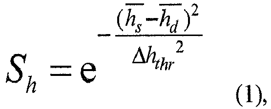
- h s represents an average height of respective ground features in the first grid to be matched in the source point cloud
- h d represents an average height of respective ground features in a set of grids in the destination point cloud, in which a distance between each of the set of grids and the first grid to be registered is smaller than the fourth preset threshold
- ⁇ h thr represents a preset value.
- each first grid to be matched in the source point cloud grids are selected from the destination point cloud, and the distance between each selected grid and the first grid to be matched is smaller than the preset fourth threshold value (for example, the fourth threshold value may be set as 50m).
- the matching degree S h between each selected grid and the first grid to be matched is calculated based on the formula (1), and a grid with the highest matching degree S h is determined as the second grid to be matched in the destination point cloud.
- the first grid to be matched comprises the non-ground feature only, or the first grid to be matched includes the ground feature and the non-ground feature
- grids are selected from the destination point cloud, in which an attribute feature of each selected grid is the same as the attribute feature of the first gird to be matched, and a distance between the selected grid and the first grid to be matched is smaller than the fourth preset threshold, a matching degree between each selected grid and the first grid to be matched is calculated, and a grid with the highest matching degree is selected as the second grid to be matched.
- x s represents an average value of x-axis coordinate values of respective non-ground features in the first grid to be matched
- x d represents an average value of x-axis coordinate values of respective non-ground features in a set of grids in the destination point cloud, in which a distance between each of the set of grids and the first grid to be matched is smaller than the fourth preset threshold
- y s represents an average value of y-axis coordinate values of respective non-ground features in the first grid to be matched
- the x-axis coordinate values and the y-axis coordinate values may be longitude and latitude values, or coordinate values under a universal transverse Mercator (UTM) grid system, or coordinate values under a Gaussian coordinate system.
- UDM universal transverse Mercator
- the grids are selected from the destination point cloud, in which, the attribute feature of each selected grid is the same as the attribute feature of the first gird to be matched, and the distance between the selected grid and the first grid to be registered is smaller than the fourth preset threshold (for example, the fourth threshold value may be set as 50m).
- S thr is a preset value, and an optimal selection value is 0.75.
- the matching degree S h is calculated based on the formula (1).
- the matching degree S f is calculated based on the formula (2). Then a sum of the matching degrees of all attribute features in the first grid to be matched is calculated, to obtain the matching degree S fh of the first grid to be matched.
- the first grid to be matched is matched with the second grid to be matched.
- the procedure for matching the first grid to be matched with the second grid to be matched includes the following.
- a relative position between the second grid to be matched and the first grid to be matched is calculated.
- a relative position between the second grid to be matched and the first grid to be matched is ⁇ d
- ⁇ d P horz src ⁇ P horz dst • dot v ⁇
- P horz src is the position of the source point cloud, which may be represented by x s and y s
- P horz dst is the position of the destination point cloud, which may be represented by x d and y d
- v is a main direction of horizontal movement.
- v is a normal direction of a normal vector.
- v is a direction perpendicular to a direction of the linear attribute feature.
- the displacement to be moved of the source point cloud is calculated according to the relative position, a matching degree corresponding to the second grid to be matched and a residual error equation.
- the relative position between the second grid to be matched and the first grid to be matched and the matching degree corresponding to the second grid to be matched are substituted into the residual error equation, thus an optimal solution of the residual error equation is obtained as the displacement to be moved of the source point cloud.
- the residual error equation may be selected from a residual error equation in the related art, which is not elaborated herein.
- the registration on the source point cloud and the destination point cloud is implemented based on the attribute feature of each grid of the plurality of grids.
- the registration for the ground features is mainly to adjust the height, while the registration for the non-ground features is mainly to adjust the horizontal position.
- a procedure for calculating the current similarity between the source point cloud and the destination point cloud will be described in detail below with reference to FIG. 5 . As illustrated in FIG. 5 , the procedure includes the following.
- a grid closest the grid in the source point cloud is selected from the destination point cloud.
- the current similarity between the source point cloud and the destination point cloud is calculated according to an attribute feature of each grid in the source point cloud.
- the similarity of the grid may be calculated based on the formula (1), which is not elaborated herein.
- the similarity of the grid may be calculated based on the formula (2), which is not elaborated herein.
- the similarity of the grid may be calculated based on the formula (3), which is not elaborated herein.
- similarities of all grids in the point cloud are synthesized to obtain the similarity between the source point cloud and the destination point cloud.
- the similarity between the source point cloud and the destination point cloud may be obtained by calculating the average value of the similarities of all grids.
- embodiments of the present disclosure further provide an apparatus for point cloud registration.
- the apparatus includes: a semantic segmentation module 61, a rasterizing module 62, a similarity calculating module 63, a determining module 64, a registration module 65, and a position updating module 66.
- the semantic segmentation module 61 is configured to segment a source point cloud into different categories of attribute features based on semantic, and to segment a destination point cloud into different categories of the attribute features based on semantic, the attribute features including a ground feature and a non-ground feature.
- the rasterizing module 62 is configured to segment the source point cloud and the destination point cloud into a plurality of grids based on the attribute features.
- the similarity calculating module 63 is configured to calculate a current similarity between the source point cloud and the destination point cloud based on the plurality of grids.
- the determining module 64 is configured to determine whether the current similarity and a current iterative number satisfy a preset condition.
- the registration module 65 is configured to perform a registration on the source point cloud and the destination point cloud to obtain a registered result when the determining module 64 determines that the current similarity and the current iterative number satisfy the preset condition.
- the position updating module 66 is configured to: based on the registered result, adjust a position of the source point cloud, update the current iterative number, and calculate an updated similarity between the destination point cloud and the source point cloud after adjusting the position.
- the determining module 64 is configured to compare the current similarity with a first preset threshold, and to compare the current iterative number with a second preset threshold; and to compare the current similarity with a previously calculated similarity when the determining module determines that the current similarity is smaller than or equal to the first threshold, and the current iterative number is smaller than the second threshold.
- the preset condition includes: the current similarity being greater than the previously calculated similarity.
- the apparatus further includes a rollback module 67.
- the rollback module 67 is configured to set back the position of the source point cloud when the determining module 64 determines that the current similarity is smaller than or equal to the previously calculated similarity.
- the registration module 65 is configured to register the source point cloud and the destination point cloud after the rollback module 67 sets back the position of the source point cloud.
- the apparatus further includes a grid size processing module 69.
- the grid size processing module 69 is configured to decrease a grid size of each of the plurality of grids according to a preset convergence step size when the determining module 64 determines that the current similarity is greater than the first threshold, or that the current iterative number is greater than or equal to the second threshold.
- the determining module 64 is further configured to determine whether the grid size decreased is greater than a third preset threshold after the grid size processing module 69 decreases the grid size of each of the plurality of grids according to the preset convergence step size.
- the registration module 62 is further configured to, after the grid size processing module 69 determines that the grid size decreased is greater than the third preset threshold, based on the grid size decreased, segment the source point cloud and the destination point cloud into a plurality of grids according to the attribute features.
- the similarity calculating module 63 is configured to calculate the current similarity between the source point cloud and the destination point cloud based on the attribute features of the plurality of grids.
- the similarity calculating module 63 is configured to: for each grid in the source point cloud, select a grid closest the grid in the source point cloud from the destination point cloud; and calculate the current similarity between the source point cloud and the destination point cloud according to an attribute feature of each grid in the source point cloud.
- the registration module 65 includes a selecting unit 651, a determining unit 652 and a matching unit 653.
- the selecting unit 651 is configured to select a first grid to be matched from the source point cloud based on the attribute features.
- the determining unit 652 is configured to determine a second grid to be matched from the destination point cloud according to an attribute feature of the first grid to be matched.
- the matching unit 653 is configured to match the first grid to be matched with the second grid to be matched.
- the determining unit 652 is configured to: when the first grid to be matched includes the ground feature only, select grids from the destination point cloud, a distance between each grid selected and the first grid to be matched being smaller than a preset fourth threshold value, calculate a matching degree between each grid selected and the first grid to be matched, and select a grid with the highest matching degree as the second grid to be matched; and when the first grid to be matched includes the non-ground feature only, or the first grid to be matched includes the ground feature and the non-ground feature, select grids from the destination point cloud, an attribute feature of each grid selected being the same as the attribute feature of the first gird to be matched, and a distance between the grid selected and the first grid to be matched being smaller than the fourth preset threshold, calculate a matching degree between each grid selected and the first grid to be matched, and select a grid with the highest matching degree as the second grid to be matched.
- the registered result includes: a displacement to be moved.
- the matching unit is configured to calculate a relative position between the second grid to be matched and the first grid to be matched; and to calculate the displacement to be moved of the source point cloud according to the relative position, a matching degree corresponding to the second grid to be matched and a residual error equation.
- the present disclosure further provides a server.
- the server includes one or more processors; and a storage device having one or more programs stored thereon.
- the one or more processors are caused to implement the method for point cloud registration described above.
- the present disclosure further provides a computer readable medium having a computer program stored thereon.
- the method for point cloud registration described above is implemented when being executed by the computer program.
- all or some of the steps in the method disclosed above, and functional modules/units in the apparatus may be implemented as software, firmware, hardware, and appropriate combinations thereof.
- the division among the functional modules/units mentioned above does not necessarily correspond to the division of physical components.
- one physical component may have a plurality of functions, or one function or step may be performed by several physical components in cooperation.
- Some or all of the physical components may be implemented as software executed by a processor, such as a central processing unit, a digital signal processor, or a microprocessor, or as hardware, or as an integrated circuit, such as a specific integrated circuit.
- Such software may be distributed on computer readable media, which may include computer storage media (or non-transitory media) and communication media (or transitory media).
- computer storage media or non-transitory media
- communication media or transitory media
- computer storage medium includes volatile and nonvolatile, removable and non-removable media implemented in any method or technology for storing information (such as computer readable instructions, data structures, program modules or other data).
- the computer storage media includes, but is not limited to, a RAM (random access memory), a ROM (read only memory), an EEPROM (electrically erasable programmable read-only memory), a flash memory or other memory technologies, a CD-ROM (compact disc read only memory), a DVD (digital versatile disk) or other optical disk storage, a magnetic cassette, a magnetic tape, a magnetic disk storage or other magnetic storage devices, or any other media that may be used to store desired information and may be accessed by a computer.
- the communication media generally includes computer readable instructions, a data structure, program modules, or other data in a modulated data signal such as a carrier wave or other transmission mechanism, and may include any information delivery medium.
Landscapes
- Engineering & Computer Science (AREA)
- Computer Vision & Pattern Recognition (AREA)
- Physics & Mathematics (AREA)
- General Physics & Mathematics (AREA)
- Theoretical Computer Science (AREA)
- Image Analysis (AREA)
Abstract
Description
- The present disclosure relates to a field of unmanned vehicle technologies, and more particularly to a method and an apparatus for point cloud registration, a server and a computer readable medium.
- Point cloud registration refers to merging two pieces of point clouds describing a same scene into one piece of point cloud data without ghosting and offset through rotation and translation. In the production of a high-precision map, due to an error of a GPS (global positioning system) of an acquisition vehicle, there are different degrees of deviations among data acquired in a plurality of trips. Therefore, the point cloud registration is essential in a high-precision map. In addition, the point cloud registration is also widely used in a scene such as a 3D (three-dimensional) modeling, 3D reconstruction.
- Presently, main methods for point cloud registration include the following.
- 1. An ICP (iterative closest point) method. In detail, for each point in a source point cloud (src), a point in a destination point cloud (dst) closest to the point is searched. A relative position between the point in the source point cloud and the point in the destination point cloud is calculated. A moving direction between the source point cloud and the destination point cloud is determined through RANSAC (random sample consensus). The above procedure is iterated until an iterative termination condition is satisfied. The computational efficiency of the ICP method is slow, especially in the high-precision map where the number of point clouds needing to be matched is in the tens of millions or hundreds of millions, the efficiency of the ICP method seriously affected. Meanwhile, the ICP method itself is sensitive to data, while collected data will be interfered by vehicles and pedestrians, which may affect a final registered result.
- 2. An ICP method based on features. In detail, features (such as a line feature, a surface feature and some special feature points) in two pieces point clouds are extracted firstly. A nearest neighbor search method is used to match the same features in the two pieces of point clouds. A relative relationship of the matched features is established at the same time. The two pieces of point clouds are moved based on the relative relationship. The above procedure is iterated until an iterative termination condition is satisfied. The ICP method based on features mainly focuses on the line feature and the surface feature for performing the point cloud registration. Although the registration efficiency meets the requirement, there is a strict requirement for the scene. If there is no required feature in the point cloud, the registration may not be provided.
- 3. Registration based on rasterized point cloud information. In detail, rasterization is performed on the source point cloud and the destination point cloud. Some statistic information of the point cloud in each grid obtained after the rasterization is recorded, such as an average height of point clouds, an average reflectance of point clouds, a height variance of point cloud, a reflectance variance of point cloud, etc. The registration is performed based on the grids under the guidance of the ICP idea. The registration based on the rasterized point cloud information has a good registration effect. However, vehicles traveling on the ground will cause interference, and there is a problem in a scene with high similarity or reflectivity failure.
- For the above disadvantages, the present disclosure provides a method and an apparatus for point cloud registration, a server and a computer readable medium.
- In the first aspect, embodiments of the present disclosure provide a method for point cloud registration. The method includes: segmenting a source point cloud into different categories of attribute features based on semantic, and segmenting a destination point cloud into different categories of the attribute features based on semantic, the attribute features including a ground feature and a non-ground feature; segmenting the source point cloud and the destination point cloud into a plurality of grids based on the attribute features; calculating a current similarity between the source point cloud and the destination point cloud based on the plurality of grids; determining whether the current similarity and a current iterative number satisfy a preset condition; in response to determining that the current similarity and the current iterative number satisfy the preset condition, performing a registration on the source point cloud and the destination point cloud to obtain a registered result; and based on the registered result, adjusting a position of the source point cloud, updating the current iterative number, and calculating an updated similarity between the destination point cloud and the source point cloud after adjusting the position.
- Preferably, determining whether the current similarity and the current iterative number satisfy the preset condition includes: comparing the current similarity with a first preset threshold, and comparing the current iterative number with a second preset threshold; and comparing the current similarity with a previously calculated similarity when the current similarity is smaller than or equal to the first threshold, and the current iterative number is smaller than the second threshold. The preset condition includes: the current similarity being greater than the previously calculated similarity.
- Further, the method further includes: when the current similarity is smaller than or equal to the previously calculated similarity, setting back the position of the source point cloud, and performing the registration on the source point cloud and the destination point cloud.
- Further, the method further includes: when the current similarity is greater than the first threshold, or the current iterative number is greater than or equal to the second threshold, decreasing a grid size of each of the plurality of grids according to a preset convergence step size; determining whether the grid size decreased is greater than a third preset threshold; in response to determining that the grid size decreased is greater than the third preset threshold, based on the grid size decreased, segmenting the source point cloud and the destination point cloud into a plurality of grids according to the attribute features.
- Preferably, calculating the current similarity between the source point cloud and the destination point cloud based on the plurality of grids includes: calculating the current similarity between the source point cloud and the destination point cloud based on the attribute features of the plurality of grids.
- Preferably, calculating the current similarity between the source point cloud and the destination point cloud based on the attribute features of the plurality of grids includes: for each grid in the source point cloud, selecting a grid closest the grid in the source point cloud from the destination point cloud; and calculating the current similarity between the source point cloud and the destination point cloud according to an attribute feature of each grid in the source point cloud.
- Preferably, performing the registration on the source point cloud and the destination point cloud to obtain the registered result includes: selecting a first grid to be matched from the source point cloud based on the attribute features; determining a second grid to be matched from the destination point cloud according to an attribute feature of the first grid to be matched; and matching the first grid to be matched with the second grid to be matched.
- Preferably, determining the second grid to be matched in the destination point cloud according to the attribute feature of the first grid to be matched includes: when the first grid to be matched includes the ground feature only, selecting grids from the destination point cloud, a distance between each grid selected and the first grid to be matched being smaller than a preset fourth threshold value, calculating a matching degree between each grid selected and the first grid to be matched, and selecting a grid with the highest matching degree as the second grid to be matched; and when the first grid to be matched includes the non-ground feature only, or the first grid to be matched includes the ground feature and the non-ground feature, selecting grids from the destination point cloud, an attribute feature of each grid selected being the same as the attribute feature of the first gird to be matched, and a distance between the grid selected and the first grid to be matched being smaller than the fourth preset threshold, calculating a matching degree between each grid selected and the first grid to be matched, and selecting a grid with the highest matching degree as the second grid to be matched.
- Preferably, when the first grid to be matched includes the ground feature only, calculating the matching degree by a formula of:

hs represents an average height of respective ground features in the first grid to be matched in the source point cloud,hd represents an average height of respective ground features in a set of grids in the destination point cloud, in which a distance between each of the set of grids and the first grid to be registered is smaller than the fourth preset threshold, and Δhthr represents a preset value; when the first grid to be matched includes the non-ground feature only, calculating the matching degree by a formula of: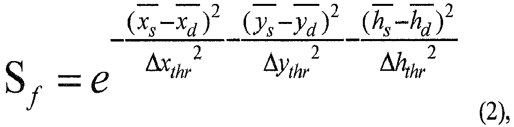
xs represents an average value of x-axis coordinate values of respective non-ground features in the first grid to be matched,xd represents an average value of x-axis coordinate values of respective non-ground features in a set of grids in the destination point cloud, in which a distance between each of the set of grids and the first grid to be matched is smaller than the fourth preset threshold,ys represents an average value of y-axis coordinate values of respective non-ground features in the first grid to be matched,yd represents an average value of y-axis coordinate values of respective non-ground features in a set of grids in the destination point cloud, in which a distance between each of the set of grids and the first grid to be matched is smaller than the fourth preset threshold,hs represents an average height of respective ground features in the first grid to be matched in the source point cloud,hd represents an average height of respective ground features in a set of grids in the target point cloud, in which a distance between each of the set of grids and the first grid to be matched is smaller than the fourth preset threshold, and Δxthr , Δythr and Δhthr represent preset values; and when the first grid to be registered includes the ground feature and the non-ground feature, calculating the matching degree by a formula of:
- Preferably, the registered result includes: a displacement to be moved; and matching the first grid to be matched with the second grid to be matched includes: calculating a relative position between the second grid to be matched and the first grid to be matched; and calculating the displacement to be moved of the source point cloud according to the relative position, a matching degree corresponding to the second grid to be matched and a residual error equation.
- In another aspect, embodiments of the present disclosure further provide an apparatus for point cloud registration. The apparatus includes: a semantic segmentation module, a rasterizing module, a similarity calculating module, a determining module, a registration module, and a position updating module.
- The semantic segmentation module is configured to segment a source point cloud into different categories of attribute features based on semantic, and to segment a destination point cloud into different categories of the attribute features based on semantic, the attribute features including a ground feature and a non-ground feature. The rasterizing module is configured to segment the source point cloud and the destination point cloud into a plurality of grids based on the attribute features. The similarity calculating module is configured to calculate a current similarity between the source point cloud and the destination point cloud based on the plurality of grids. The determining module is configured to determine whether the current similarity and a current iterative number satisfy a preset condition. The registration module is configured to perform a registration on the source point cloud and the destination point cloud to obtain a registered result in response to determining that the current similarity and the current iterative number satisfy the preset condition. The position updating module is configured to, based on the registered result, adjust a position of the source point cloud, update the current iterative number, and calculate an updated similarity between the destination point cloud and the source point cloud after adjusting the position.
- Preferably, the determining module is configured to compare the current similarity with a first preset threshold, and to compare the current iterative number with a second preset threshold; and to compare the current similarity with a previously calculated similarity when current similarity is smaller than or equal to the first threshold, and the current iterative number is smaller than the second threshold; and the preset condition includes: the current similarity being greater than the previously calculated similarity.
- Further, the apparatus further includes a rollback module.
- The rollback module is configured to set back the position of the source point cloud when the determining module determines that the current similarity is smaller than or equal to the previously calculated similarity. The registration module is configured to register the source point cloud and the destination point cloud after the rollback module sets back the position of the source point cloud.
- The present disclosure further provides a server. The server includes one or more processors; and a storage device having one or more programs stored thereon. When the one or more programs are executed by the one or more processors, the one or more processors are caused to implement the method for point cloud registration described above.
- The present disclosure further provides a computer readable medium having a computer program stored thereon. The method for point cloud registration described above is implemented when being executed by the computer program.
- With embodiments of the present disclosure, semantic segmentation and rasterization are combined to be performed on the point cloud, more abundant feature information except the height and the reflectivity in the point cloud is provided due to diversity of the attribute features of the point cloud, and different registration solution may be employed for different attribute features, thereby improving the matching accuracy. On the one hand, taking the attribute feature as the basis of registration may also improve the matching accuracy for some strong feature scenes with less point cloud data. On the other hand, semantic segmentation may also remove noise matching the interference from the vehicle, the pedestrian and the like, further improving the matching accuracy. For a scene with a large error (larger than 5m) of collected data, the effect of point cloud registration is particularly obvious by employing the solution of embodiments of the present disclosure.
-
-
FIG. 1 illustrates a flow chart of a method for point cloud registration according to an embodiment of the present disclosure. -
FIG. 2 illustrates a flow chart of a method for point cloud registration according to another embodiment of the present disclosure. -
FIG. 3 illustrates a flow chart of a registration procedure according to an embodiment of the present disclosure. -
FIG. 4 illustrates a flow chart of matching a first grid to be matched with a second grid to be matched according to an embodiment of the present disclosure. -
FIG. 5 illustrates a flow chart of calculating a similarity according to an embodiment of the present disclosure. -
FIG. 6 illustrates a block diagram of an apparatus for point cloud registration according to an embodiment of the present disclosure. -
FIG. 7 illustrates a block diagram of an apparatus for point cloud registration according to another embodiment of the present disclosure. -
FIG. 8 illustrates a block diagram of an apparatus for point cloud registration according to an embodiment of the present disclosure. -
FIG. 9 illustrates a block diagram of a registration module according to an embodiment of the present disclosure. - Exemplary embodiments will be described fully below with reference to accompanying drawings. However, the exemplary embodiments may be embodied in different forms and should not be construed as a limitation of embodiments described herein. On the contrary, these embodiments are provided to enable the present disclosure thorough and complete, and to enable the skilled in the art to fully understand the scope of the present disclosure.
- As used herein, terms "and/or" include any and all combinations of one or more related enumerated items.
- Terms used herein are intended only to describe a specific embodiment, and are not construed to limit the present disclosure. As used herein, "a" and "the" in singular forms mean including plural forms, unless clearly indicated in the context otherwise. It should be further understood that, when used in the specification, terms "comprising" and/or "including" specify the presence of stated features, entities, steps, operations, elements and/or components, but do not exclude the presence or addition of one or more other features, entities, steps, operations, elements, components and/or groups thereof.
- The embodiments described herein may be described with reference to plan and/or cross-sectional schematic diagrams by means of ideal schematic diagrams of the present disclosure. Therefore, the exemplary diagram may be modified according to manufacturing techniques and/or tolerances. Embodiments are not limited to the embodiments illustrated in the accompanying drawings, but include modifications of configurations formed based on manufacturing processes. A region illustrated in the accompanying drawings has a schematic attribute, and a shape of the region illustrated in the accompanying drawings illustrates a specific shape of the region of an element, but are not intended to limit thereto.
- Unless otherwise defined, all terms (including technical and scientific terms) used herein have the same meaning as commonly understood by the skilled in the art. It should be understood that, the term such as that defined in a commonly used dictionary should be interpreted as having a meaning consistent with its meaning in the context of the related art and the present disclosure, and will not be interpreted as having an idealized or overly formal meaning unless explicitly defined herein.
- Presently, an average recall rate of point clouds based on semantic segmentation is about 95%. The present disclosure provides a method for point cloud registration in combination with a method for performing semantic segmentation on a point cloud and a method for performing rasterization on the point cloud, and pointedly provides a matching strategy and a similarity evaluation strategy.
- An embodiment of the present disclosure provides a method for point cloud registration. Detailed description will be made below to the method for the point cloud registration with reference to
FIG. 1 . As illustrated inFIG. 1 , the method includes the following. - At block S11, a source point cloud is segmented into different categories of attribute features based on semantic, and a destination point cloud is segmented into different categories of the attribute features based on semantic.
- In detail, the attribute features include a ground feature and a non-ground feature. Categories of the ground feature may include ground, a lane line, etc.. Categories of the non-ground feature may include a guardrail, a curb, a signpost, a rod-shaped object, a viaduct, etc.
- The actions at this block are used for semantic segmentation. The detailed implementation for distinguishing the attribute features of the point cloud based on the semantic according to the categories belongs to the related art, which is not elaborated herein.
- At block S12, the source point cloud and the destination point cloud are segmented into a plurality of grids based on the attribute features.
- The further away the point clouds, the rarer and sparser the point clouds. Therefore, in embodiments of the present disclosure, a specified grid size is 60m∗60m. The point cloud may include noise interference from a car, a pedestrian and the like. Therefore, in order to ensure the accuracy for point cloud registration, a point cloud of the noise may not be placed in the grid during performing the rasterization on the point cloud.
- Content of each grid is defined as follows:
     cell {
     cell.base_box_info
     cell.ground_box_info
     cell.barrier_info
     ...
     }
where box_info may include parameters of the attribute feature, such as a length, a width, a height, an average height, an average reflectivity and the like.


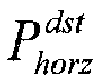
when the first grid to be matched includes the non-ground feature only, calculate the matching degree by a formula of:

when the first grid to be registered includes the ground feature and the non-ground feature, calculate the matching degree by a formula of:

Claims (15)
- A method for point cloud registration, comprising:segmenting (S11) a source point cloud into different categories of attribute features based on semantic, and segmenting a destination point cloud into different categories of the attribute features based on semantic, the attribute features comprising a ground feature and a non-ground feature;segmenting (S12) the source point cloud and the destination point cloud into a plurality of grids based on the attribute features;calculating (S13) a current similarity between the source point cloud and the destination point cloud based on the plurality of grids;determining (S14) whether the current similarity and a current iterative number satisfy a preset condition;in response to determining that the current similarity and the current iterative number satisfy the preset condition, performing (S15) a registration on the source point cloud and the destination point cloud to obtain a registered result; andbased on the registered result, adjusting (S16) a position of the source point cloud, updating the current iterative number, and calculating an updated similarity between the destination point cloud and the source point cloud after adjusting the position.
- The method of claim 1, wherein determining whether (S14) the current similarity and the current iterative number satisfy the preset condition comprises:comparing the current similarity with a first preset threshold, and comparing the current iterative number with a second preset threshold; andcomparing the current similarity with a previously calculated similarity when the current similarity is smaller than or equal to the first threshold, and the current iterative number is smaller than the second threshold; andwherein the preset condition comprises: the current similarity being greater than the previously calculated similarity.
- The method of claim 2, further comprising:
when the current similarity is smaller than or equal to the previously calculated similarity, setting back (S23) the position of the source point cloud, and performing the registration on the source point cloud and the destination point cloud. - The method of claim 2, further comprising:when the current similarity is greater than the first threshold, or the current iterative number is greater than or equal to the second threshold, decreasing (S24) a grid size of each of the plurality of grids according to a preset convergence step size;determining (S25) whether the grid size decreased is greater than a third preset threshold;in response to determining that the grid size decreased is greater than the third preset threshold, based on the grid size decreased, segmenting the source point cloud and the destination point cloud into a plurality of grids according to the attribute features.
- The method of any of claims 1-4, wherein calculating (S13) the current similarity between the source point cloud and the destination point cloud based on the plurality of grids comprises:
calculating the current similarity between the source point cloud and the destination point cloud based on the attribute features of the plurality of grids. - The method of claim 5, wherein calculating the current similarity between the source point cloud and the destination point cloud based on the attribute features of the plurality of grids comprises:for each grid in the source point cloud, selecting (S51) a grid closest the grid in the source point cloud from the destination point cloud; andcalculating (S52) the current similarity between the source point cloud and the destination point cloud according to an attribute feature of each grid in the source point cloud.
- The method of any of claims 1-4, wherein performing (S15) the registration on the source point cloud and the destination point cloud to obtain the registered result comprises:selecting (S31) a first grid to be matched from the source point cloud based on the attribute features;determining (S32) a second grid to be matched from the destination point cloud according to an attribute feature of the first grid to be matched; andmatching (S33) the first grid to be matched with the second grid to be matched.
- The method of claim 7, wherein determining (S32) the second grid to be matched in the destination point cloud according to the attribute feature of the first grid to be matched comprises:when the first grid to be matched comprises the ground feature only, selecting grids from the destination point cloud, a distance between each grid selected and the first grid to be matched being smaller than a preset fourth threshold value, calculating a matching degree between each grid selected and the first grid to be matched, and selecting a grid with the highest matching degree as the second grid to be matched; andwhen the first grid to be matched comprises the non-ground feature only, or the first grid to be matched comprises the ground feature and the non-ground feature, selecting grids from the destination point cloud, an attribute feature of each grid selected being the same as the attribute feature of the first gird to be matched, and a distance between the grid selected and the first grid to be matched being smaller than the fourth preset threshold, calculating a matching degree between each grid selected and the first grid to be matched, and selecting a grid with the highest matching degree as the second grid to be matched.
- The method of claim 8, wherein when the first grid to be matched comprises the ground feature only, calculating the matching degree by a formula of:
 where,
hs represents an average height of respective ground features in the first grid to be matched in the source point cloud,hd represents an average height of respective ground features in a set of grids in the destination point cloud, in which a distance between each of the set of grids and the first grid to be registered is smaller than the fourth preset threshold, and Δhthr represents a preset value;when the first grid to be matched comprises the non-ground feature only, calculating the matching degree by a formula of: where,
xs represents an average value of x-axis coordinate values of respective non-ground features in the first grid to be matched,xd represents an average value of x-axis coordinate values of respective non-ground features in a set of grids in the destination point cloud, in which a distance between each of the set of grids and the first grid to be matched is smaller than the fourth preset threshold,ys represents an average value of y-axis coordinate values of respective non-ground features in the first grid to be matched,yd represents an average value of y-axis coordinate values of respective non-ground features in a set of grids in the destination point cloud, in which a distance between each of the set of grids and the first grid to be matched is smaller than the fourth preset threshold,hs represents an average height of respective ground features in the first grid to be matched in the source point cloud,hd represents an average height of respective ground features in a set of grids in the target point cloud, in which a distance between each of the set of grids and the first grid to be matched is smaller than the fourth preset threshold, and Δxthr , Δythr and Δhthr represent preset values; andwhen the first grid to be registered comprises the ground feature and the non-ground feature, calculating the matching degree by a formula of:
- The method of claim 7, wherein the registered result comprises: a displacement to be moved; and matching the first grid to be matched with the second grid to be matched comprises:calculating (S41) a relative position between the second grid to be matched and the first grid to be matched; andcalculating (S42) the displacement to be moved of the source point cloud according to the relative position, a matching degree corresponding to the second grid to be matched and a residual error equation.
- An apparatus for point cloud registration, comprising:a semantic segmentation module (61), configured to segment a source point cloud into different categories of attribute features based on semantic, and to segment a destination point cloud into different categories of the attribute features based on semantic, the attribute features comprising a ground feature and a non-ground feature;a rasterizing module (62), configured to segment the source point cloud and the destination point cloud into a plurality of grids based on the attribute features;a similarity calculating module (63), configured to calculate a current similarity between the source point cloud and the destination point cloud based on the plurality of grids;a determining module (64), configured to determine whether the current similarity and a current iterative number satisfy a preset condition; anda registration module (65), configured to perform a registration on the source point cloud and the destination point cloud to obtain a registered result when the determining module determines that the current similarity and the current iterative number satisfy the preset condition; anda position updating module (66), configured to, based on the registered result, adjust a position of the source point cloud, update the current iterative number, and calculate an updated similarity between the destination point cloud and the source point cloud after adjusting the position.
- The apparatus of claim 11, wherein the determining module (64) is configured to compare the current similarity with a first preset threshold, and to compare the current iterative number with a second preset threshold; and to compare the current similarity with a previously calculated similarity when the current similarity is smaller than or equal to the first threshold, and the current iterative number is smaller than the second threshold; and
wherein the preset condition comprises:
the current similarity being greater than the previously calculated similarity. - The apparatus of claim 12, further comprising: a rollback module (67), wherein
the rollback module (67) is configured to set back the position of the source point cloud when the determining module determines that the current similarity is smaller than or equal to the previously calculated similarity, and
the registration module (65) is configured to register the source point cloud and the destination point cloud after the rollback module sets back the position of the source point cloud. - A server, comprising:one or more processors; anda storage device having one or more programs stored thereon,wherein when the one or more programs are executed by the one or more processors, the one or more processors are caused to implement the method for point cloud registration according to any one of claims 1-10.
- A computer readable medium having a computer program stored thereon, wherein the method for point cloud registration according to any one of claims 1-10 is implemented when being executed by the computer program.
Applications Claiming Priority (1)
| Application Number | Priority Date | Filing Date | Title |
|---|---|---|---|
| CN201910334541.0A CN110084840B (en) | 2019-04-24 | 2019-04-24 | Point cloud registration method, device, server and computer readable medium |
Publications (1)
| Publication Number | Publication Date |
|---|---|
| EP3731181A1 true EP3731181A1 (en) | 2020-10-28 |
Family
ID=67416448
Family Applications (1)
| Application Number | Title | Priority Date | Filing Date |
|---|---|---|---|
| EP20161347.8A Withdrawn EP3731181A1 (en) | 2019-04-24 | 2020-03-06 | Method and apparatus for point cloud registration, server and computer readable medium |
Country Status (3)
| Country | Link |
|---|---|
| US (1) | US11158071B2 (en) |
| EP (1) | EP3731181A1 (en) |
| CN (1) | CN110084840B (en) |
Cited By (9)
| Publication number | Priority date | Publication date | Assignee | Title |
|---|---|---|---|---|
| CN113436238A (en) * | 2021-08-27 | 2021-09-24 | 湖北亿咖通科技有限公司 | Point cloud registration accuracy evaluation method and device and electronic equipment |
| CN113628258A (en) * | 2021-04-25 | 2021-11-09 | 西安理工大学 | Point cloud rough registration method based on self-adaptive feature point extraction |
| CN113674332A (en) * | 2021-08-19 | 2021-11-19 | 上海应用技术大学 | Point cloud registration method based on topological structure and multi-scale features |
| CN114926325A (en) * | 2022-06-07 | 2022-08-19 | 中南大学 | Point cloud registration method, system and storage medium |
| CN115760939A (en) * | 2022-11-30 | 2023-03-07 | 江苏方天电力技术有限公司 | A laser point cloud iterative registration method, device and storage medium |
| CN116468762A (en) * | 2023-04-17 | 2023-07-21 | 南京邮电大学 | Substation site cloud registration method and device, electronic equipment and storage medium |
| CN116704108A (en) * | 2022-02-24 | 2023-09-05 | 比亚迪股份有限公司 | Road condition modeling method, road condition model obtaining method, cloud platform and vehicle-mounted system |
| CN117670785A (en) * | 2022-08-31 | 2024-03-08 | 北京三快在线科技有限公司 | Ghost detection method for point cloud maps |
| CN120912649A (en) * | 2025-10-11 | 2025-11-07 | 湖北华中电力科技开发有限责任公司 | Automatic registration method for power grid line point cloud |
Families Citing this family (28)
| Publication number | Priority date | Publication date | Assignee | Title |
|---|---|---|---|---|
| CN110084840B (en) * | 2019-04-24 | 2022-05-13 | 阿波罗智能技术(北京)有限公司 | Point cloud registration method, device, server and computer readable medium |
| WO2021056190A1 (en) * | 2019-09-24 | 2021-04-01 | Beijing Didi Infinity Technology And Development Co., Ltd. | Semantic-assisted multi-resolution point cloud registration |
| WO2021115961A1 (en) * | 2019-12-11 | 2021-06-17 | Continental Automotive Gmbh | Method for reconstruction of a feature in an environmental scene of a road |
| CN111461982B (en) * | 2020-03-30 | 2023-09-22 | 北京百度网讯科技有限公司 | Method and device for splicing point clouds |
| FR3111067A1 (en) * | 2020-06-06 | 2021-12-10 | Olivier Querbes | Optical impression of a patient's dental arch |
| CN113763438B (en) * | 2020-06-28 | 2024-04-19 | 北京京东叁佰陆拾度电子商务有限公司 | Point cloud registration method, device, equipment and storage medium |
| CN111929694B (en) * | 2020-10-12 | 2021-01-26 | 炬星科技(深圳)有限公司 | Point cloud matching method, device and storage medium |
| WO2022087916A1 (en) * | 2020-10-28 | 2022-05-05 | 华为技术有限公司 | Positioning method and apparatus, and electronic device and storage medium |
| CN112446907B (en) * | 2020-11-19 | 2022-09-06 | 武汉中海庭数据技术有限公司 | Method and device for registering single-line point cloud and multi-line point cloud |
| CN112967325B (en) * | 2021-02-08 | 2023-07-21 | 北京大学 | A signal restoration enhancement method and device |
| CN115236694A (en) * | 2021-04-15 | 2022-10-25 | 阿里巴巴新加坡控股有限公司 | Obstacle detection method, device, electronic device and storage medium |
| CN113256712B (en) * | 2021-06-01 | 2023-04-18 | 北京有竹居网络技术有限公司 | Positioning method, positioning device, electronic equipment and storage medium |
| CN113313200B (en) * | 2021-06-21 | 2024-04-16 | 中国科学院自动化研究所苏州研究院 | Point cloud precision matching method based on normal constraint |
| CN113436336B (en) * | 2021-06-22 | 2024-01-12 | 京东鲲鹏(江苏)科技有限公司 | Ground point cloud segmentation method and device and automatic driving vehicle |
| CN113589243B (en) * | 2021-07-30 | 2023-09-05 | 北京经纬恒润科技股份有限公司 | Radar calibration method, device, equipment and storage medium |
| CN113920217B (en) * | 2021-10-15 | 2025-09-12 | 北京百度网讯科技有限公司 | Method, device, equipment and product for generating lane lines on high-precision maps |
| CN114442101B (en) * | 2022-01-28 | 2023-11-14 | 南京慧尔视智能科技有限公司 | Vehicle navigation method, device, equipment and medium based on imaging millimeter wave radar |
| CN114943870B (en) * | 2022-04-07 | 2025-04-25 | 浙江菜鸟传橙网络技术有限公司 | Line feature extraction model training method and device, point cloud matching method and device |
| CN115063475B (en) * | 2022-06-28 | 2025-08-05 | 上海仙工智能科技股份有限公司 | A surface shape recognition and positioning method based on 3D sensor |
| CN115239957B (en) * | 2022-07-26 | 2026-03-17 | 白犀牛智达(北京)科技有限公司 | A ground segmentation method |
| US12094058B2 (en) | 2022-08-19 | 2024-09-17 | Fluid Dynamic Sciences, Llc | Fast feature recognition and mesh generation in structural design |
| GB2623771A (en) * | 2022-10-25 | 2024-05-01 | Through Leaves Ltd | Combining three-dimensional images |
| CN116030131B (en) * | 2022-12-29 | 2025-11-28 | 新石器慧通(北京)科技有限公司 | Pose determining method and device |
| CN116310412B (en) * | 2023-01-29 | 2025-09-09 | 广州文远知行科技有限公司 | Point cloud matching detection method, device, equipment and storage medium |
| CN116128943B (en) * | 2023-02-20 | 2026-04-10 | 北京超星未来科技有限公司 | A point cloud matching method, apparatus, computer device, and storage medium |
| CN116309834A (en) * | 2023-02-28 | 2023-06-23 | 深圳元戎启行科技有限公司 | Mobile device positioning method, device and mobile device |
| CN119741349B (en) * | 2024-11-13 | 2025-10-24 | 浙江工业大学 | A multi-view heterogeneous point cloud registration method and device based on semantic segmentation |
| CN119359777B (en) * | 2024-12-24 | 2025-03-21 | 安徽工布智造工业科技有限公司 | Precision registration method and system based on 3D point cloud and model contour |
Citations (1)
| Publication number | Priority date | Publication date | Assignee | Title |
|---|---|---|---|---|
| CN105427317A (en) * | 2015-11-25 | 2016-03-23 | 武汉大学 | Method suitable for multi-view-angle automatic registration of ground laser point cloud data of multiple stations |
Family Cites Families (21)
| Publication number | Priority date | Publication date | Assignee | Title |
|---|---|---|---|---|
| US8525835B1 (en) * | 2010-02-24 | 2013-09-03 | The Boeing Company | Spatial data compression using implicit geometry |
| CN103295239B (en) * | 2013-06-07 | 2016-05-11 | 北京建筑工程学院 | A kind of autoegistration method of the laser point cloud data based on datum plane image |
| US9740711B2 (en) * | 2013-11-07 | 2017-08-22 | Autodesk, Inc. | Automatic registration |
| GB2520338A (en) * | 2013-11-19 | 2015-05-20 | Nokia Corp | Automatic scene parsing |
| US10029804B1 (en) * | 2015-05-14 | 2018-07-24 | Near Earth Autonomy, Inc. | On-board, computerized landing zone evaluation system for aircraft |
| US9710714B2 (en) * | 2015-08-03 | 2017-07-18 | Nokia Technologies Oy | Fusion of RGB images and LiDAR data for lane classification |
| US9760996B2 (en) * | 2015-08-11 | 2017-09-12 | Nokia Technologies Oy | Non-rigid registration for large-scale space-time 3D point cloud alignment |
| CN105702151B (en) * | 2016-03-31 | 2019-06-11 | 百度在线网络技术(北京)有限公司 | A kind of indoor map construction method and device |
| CN106803267B (en) * | 2017-01-10 | 2020-04-14 | 西安电子科技大学 | 3D reconstruction method of indoor scene based on Kinect |
| US10176589B2 (en) * | 2017-01-31 | 2019-01-08 | Mitsubishi Electric Research Labroatories, Inc. | Method and system for completing point clouds using planar segments |
| CN107038717B (en) * | 2017-04-14 | 2019-08-27 | 东南大学 | A Method for Automatically Analyzing 3D Point Cloud Registration Errors Based on Stereo Grid |
| US20180349522A1 (en) * | 2017-06-05 | 2018-12-06 | Siteaware Systems Ltd. | Adaptive Modeling of Buildings During Construction |
| EP3457357B1 (en) * | 2017-09-13 | 2021-07-07 | Tata Consultancy Services Limited | Methods and systems for surface fitting based change detection in 3d point-cloud |
| CN109697728B (en) * | 2017-10-20 | 2023-04-25 | 阿里巴巴集团控股有限公司 | Data processing method, device, system and storage medium |
| US10657390B2 (en) * | 2017-11-27 | 2020-05-19 | Tusimple, Inc. | System and method for large-scale lane marking detection using multimodal sensor data |
| US10748027B2 (en) * | 2018-10-02 | 2020-08-18 | International Business Machines Corporation | Construction of an efficient representation for a three-dimensional (3D) compound object from raw video data |
| US10915793B2 (en) * | 2018-11-08 | 2021-02-09 | Huawei Technologies Co., Ltd. | Method and system for converting point cloud data for use with 2D convolutional neural networks |
| US10846817B2 (en) * | 2018-11-15 | 2020-11-24 | Toyota Research Institute, Inc. | Systems and methods for registering 3D data with 2D image data |
| US10867430B2 (en) * | 2018-11-19 | 2020-12-15 | Intel Corporation | Method and system of 3D reconstruction with volume-based filtering for image processing |
| US11113959B2 (en) * | 2018-12-28 | 2021-09-07 | Intel Corporation | Crowdsourced detection, identification and sharing of hazardous road objects in HD maps |
| CN110084840B (en) * | 2019-04-24 | 2022-05-13 | 阿波罗智能技术(北京)有限公司 | Point cloud registration method, device, server and computer readable medium |
-
2019
- 2019-04-24 CN CN201910334541.0A patent/CN110084840B/en active Active
-
2020
- 2020-03-06 EP EP20161347.8A patent/EP3731181A1/en not_active Withdrawn
- 2020-03-18 US US16/823,288 patent/US11158071B2/en active Active
Patent Citations (1)
| Publication number | Priority date | Publication date | Assignee | Title |
|---|---|---|---|---|
| CN105427317A (en) * | 2015-11-25 | 2016-03-23 | 武汉大学 | Method suitable for multi-view-angle automatic registration of ground laser point cloud data of multiple stations |
Non-Patent Citations (3)
| Title |
|---|
| ANESTIS ZAGANIDIS ET AL: "Integrating Deep Semantic Segmentation into 3D Point Cloud Registration", 1 January 2018 (2018-01-01), pages 2942 - 2949, XP055664374, Retrieved from the Internet <URL:https://github.com/mengyuest/iros2018-slam-papers/raw/master/9deepslam/5.Integrating%20Deep%20Semantic%20Segmentation%20into%203D%20Point%20Cloud%20Registration.pdf> DOI: 10.1109/LRA.2018.2848308 * |
| YU FISHER ET AL: "Semantic alignment of LiDAR data at city scale", 2015 IEEE CONFERENCE ON COMPUTER VISION AND PATTERN RECOGNITION (CVPR), IEEE, 7 June 2015 (2015-06-07), pages 1722 - 1731, XP032793629, DOI: 10.1109/CVPR.2015.7298781 * |
| ZAGANIDIS ANESTIS ET AL: "Semantic-assisted 3D normal distributions transform for scan registration in environments with limited structure", 2017 IEEE/RSJ INTERNATIONAL CONFERENCE ON INTELLIGENT ROBOTS AND SYSTEMS (IROS), IEEE, 24 September 2017 (2017-09-24), pages 4064 - 4069, XP033266413, DOI: 10.1109/IROS.2017.8206262 * |
Cited By (11)
| Publication number | Priority date | Publication date | Assignee | Title |
|---|---|---|---|---|
| CN113628258A (en) * | 2021-04-25 | 2021-11-09 | 西安理工大学 | Point cloud rough registration method based on self-adaptive feature point extraction |
| CN113628258B (en) * | 2021-04-25 | 2024-04-26 | 西安理工大学 | A point cloud coarse registration method based on adaptive feature point extraction |
| CN113674332A (en) * | 2021-08-19 | 2021-11-19 | 上海应用技术大学 | Point cloud registration method based on topological structure and multi-scale features |
| CN113674332B (en) * | 2021-08-19 | 2024-05-21 | 上海应用技术大学 | A point cloud registration method based on topological structure and multi-scale features |
| CN113436238A (en) * | 2021-08-27 | 2021-09-24 | 湖北亿咖通科技有限公司 | Point cloud registration accuracy evaluation method and device and electronic equipment |
| CN116704108A (en) * | 2022-02-24 | 2023-09-05 | 比亚迪股份有限公司 | Road condition modeling method, road condition model obtaining method, cloud platform and vehicle-mounted system |
| CN114926325A (en) * | 2022-06-07 | 2022-08-19 | 中南大学 | Point cloud registration method, system and storage medium |
| CN117670785A (en) * | 2022-08-31 | 2024-03-08 | 北京三快在线科技有限公司 | Ghost detection method for point cloud maps |
| CN115760939A (en) * | 2022-11-30 | 2023-03-07 | 江苏方天电力技术有限公司 | A laser point cloud iterative registration method, device and storage medium |
| CN116468762A (en) * | 2023-04-17 | 2023-07-21 | 南京邮电大学 | Substation site cloud registration method and device, electronic equipment and storage medium |
| CN120912649A (en) * | 2025-10-11 | 2025-11-07 | 湖北华中电力科技开发有限责任公司 | Automatic registration method for power grid line point cloud |
Also Published As
| Publication number | Publication date |
|---|---|
| US11158071B2 (en) | 2021-10-26 |
| US20200342614A1 (en) | 2020-10-29 |
| CN110084840A (en) | 2019-08-02 |
| CN110084840B (en) | 2022-05-13 |
Similar Documents
| Publication | Publication Date | Title |
|---|---|---|
| US11158071B2 (en) | Method and apparatus for point cloud registration, and computer readable medium | |
| US12174641B2 (en) | Vehicle localization based on radar detections | |
| CN110443225B (en) | Virtual and real lane line identification method and device based on feature pixel statistics | |
| EP3519770B1 (en) | Methods and systems for generating and using localisation reference data | |
| JP6595182B2 (en) | Systems and methods for mapping, locating, and attitude correction | |
| US20200152060A1 (en) | Underground garage parking space extraction method and system for high-definition map making | |
| US10748032B1 (en) | Method for providing robust object distance estimation based on camera by performing pitch calibration of camera more precisely with fusion of information acquired through camera and information acquired through V2V communication and device using the same | |
| CN104677361B (en) | A kind of method of comprehensive location | |
| KR102675523B1 (en) | Method and apparatus of determining lane | |
| KR20190090393A (en) | Lane determining method, device and storage medium | |
| CN115731527B (en) | Road boundary detection methods, devices, computer equipment and storage media | |
| CN107850445A (en) | Method and system for generating and using locating reference datum | |
| CN105667518A (en) | Lane detection method and device | |
| EP4027169A2 (en) | Radar reference map generation | |
| CN114646957B (en) | Method and apparatus for radar reference map generation | |
| CN114267027A (en) | Image processing method and device | |
| CN113096181A (en) | Method and device for determining pose of equipment, storage medium and electronic device | |
| CN113835102A (en) | Lane line generation method and device | |
| CN112435336B (en) | Curve type identification method and device, electronic equipment and storage medium | |
| CN112907659B (en) | Mobile equipment positioning system, method and equipment | |
| CN112733971A (en) | Pose determination method, device and equipment of scanning equipment and storage medium | |
| CN114155509B (en) | A road traversable area extraction method and extraction system | |
| CN115704900B (en) | Point cloud data processing method, device, equipment and storage medium | |
| CN116299540B (en) | Laser radar target heading angle fitting method and device | |
| Yang et al. | A marker-free calibration method for mobile laser scanning point clouds correction |
Legal Events
| Date | Code | Title | Description |
|---|---|---|---|
| PUAI | Public reference made under article 153(3) epc to a published international application that has entered the european phase |
Free format text: ORIGINAL CODE: 0009012 |
|
| STAA | Information on the status of an ep patent application or granted ep patent |
Free format text: STATUS: THE APPLICATION HAS BEEN PUBLISHED |
|
| AK | Designated contracting states |
Kind code of ref document: A1 Designated state(s): AL AT BE BG CH CY CZ DE DK EE ES FI FR GB GR HR HU IE IS IT LI LT LU LV MC MK MT NL NO PL PT RO RS SE SI SK SM TR |
|
| AX | Request for extension of the european patent |
Extension state: BA ME |
|
| STAA | Information on the status of an ep patent application or granted ep patent |
Free format text: STATUS: REQUEST FOR EXAMINATION WAS MADE |
|
| 17P | Request for examination filed |
Effective date: 20210427 |
|
| RBV | Designated contracting states (corrected) |
Designated state(s): AL AT BE BG CH CY CZ DE DK EE ES FI FR GB GR HR HU IE IS IT LI LT LU LV MC MK MT NL NO PL PT RO RS SE SI SK SM TR |
|
| RAP1 | Party data changed (applicant data changed or rights of an application transferred) |
Owner name: APOLLO INTELLIGENT DRIVING TECHNOLOGY (BEIJING) CO., LTD. |
|
| STAA | Information on the status of an ep patent application or granted ep patent |
Free format text: STATUS: EXAMINATION IS IN PROGRESS |
|
| 17Q | First examination report despatched |
Effective date: 20220523 |
|
| STAA | Information on the status of an ep patent application or granted ep patent |
Free format text: STATUS: THE APPLICATION HAS BEEN WITHDRAWN |
|
| 18W | Application withdrawn |
Effective date: 20240307 |