EP3683540A1 - Antenna downtilt angle measurement method based on depth instance segmentation network - Google Patents
Antenna downtilt angle measurement method based on depth instance segmentation network Download PDFInfo
- Publication number
- EP3683540A1 EP3683540A1 EP19870064.3A EP19870064A EP3683540A1 EP 3683540 A1 EP3683540 A1 EP 3683540A1 EP 19870064 A EP19870064 A EP 19870064A EP 3683540 A1 EP3683540 A1 EP 3683540A1
- Authority
- EP
- European Patent Office
- Prior art keywords
- antenna
- downtilt angle
- measuring
- module
- instance segmentation
- Prior art date
- Legal status (The legal status is an assumption and is not a legal conclusion. Google has not performed a legal analysis and makes no representation as to the accuracy of the status listed.)
- Withdrawn
Links
Images


Classifications
-
- G—PHYSICS
- G06—COMPUTING OR CALCULATING; COUNTING
- G06T—IMAGE DATA PROCESSING OR GENERATION, IN GENERAL
- G06T7/00—Image analysis
- G06T7/70—Determining position or orientation of objects or cameras
- G06T7/73—Determining position or orientation of objects or cameras using feature-based methods
-
- G—PHYSICS
- G06—COMPUTING OR CALCULATING; COUNTING
- G06T—IMAGE DATA PROCESSING OR GENERATION, IN GENERAL
- G06T7/00—Image analysis
- G06T7/70—Determining position or orientation of objects or cameras
-
- G—PHYSICS
- G01—MEASURING; TESTING
- G01C—MEASURING DISTANCES, LEVELS OR BEARINGS; SURVEYING; NAVIGATION; GYROSCOPIC INSTRUMENTS; PHOTOGRAMMETRY OR VIDEOGRAMMETRY
- G01C1/00—Measuring angles
-
- G—PHYSICS
- G01—MEASURING; TESTING
- G01C—MEASURING DISTANCES, LEVELS OR BEARINGS; SURVEYING; NAVIGATION; GYROSCOPIC INSTRUMENTS; PHOTOGRAMMETRY OR VIDEOGRAMMETRY
- G01C11/00—Photogrammetry or videogrammetry, e.g. stereogrammetry; Photographic surveying
- G01C11/04—Interpretation of pictures
-
- G—PHYSICS
- G06—COMPUTING OR CALCULATING; COUNTING
- G06N—COMPUTING ARRANGEMENTS BASED ON SPECIFIC COMPUTATIONAL MODELS
- G06N20/00—Machine learning
-
- G—PHYSICS
- G06—COMPUTING OR CALCULATING; COUNTING
- G06N—COMPUTING ARRANGEMENTS BASED ON SPECIFIC COMPUTATIONAL MODELS
- G06N3/00—Computing arrangements based on biological models
- G06N3/02—Neural networks
- G06N3/04—Architecture, e.g. interconnection topology
- G06N3/045—Combinations of networks
-
- G—PHYSICS
- G06—COMPUTING OR CALCULATING; COUNTING
- G06N—COMPUTING ARRANGEMENTS BASED ON SPECIFIC COMPUTATIONAL MODELS
- G06N3/00—Computing arrangements based on biological models
- G06N3/02—Neural networks
- G06N3/04—Architecture, e.g. interconnection topology
- G06N3/0464—Convolutional networks [CNN, ConvNet]
-
- G—PHYSICS
- G06—COMPUTING OR CALCULATING; COUNTING
- G06N—COMPUTING ARRANGEMENTS BASED ON SPECIFIC COMPUTATIONAL MODELS
- G06N3/00—Computing arrangements based on biological models
- G06N3/02—Neural networks
- G06N3/08—Learning methods
- G06N3/084—Backpropagation, e.g. using gradient descent
-
- G—PHYSICS
- G06—COMPUTING OR CALCULATING; COUNTING
- G06N—COMPUTING ARRANGEMENTS BASED ON SPECIFIC COMPUTATIONAL MODELS
- G06N3/00—Computing arrangements based on biological models
- G06N3/02—Neural networks
- G06N3/08—Learning methods
- G06N3/09—Supervised learning
-
- G—PHYSICS
- G06—COMPUTING OR CALCULATING; COUNTING
- G06T—IMAGE DATA PROCESSING OR GENERATION, IN GENERAL
- G06T7/00—Image analysis
- G06T7/10—Segmentation; Edge detection
- G06T7/11—Region-based segmentation
-
- G—PHYSICS
- G06—COMPUTING OR CALCULATING; COUNTING
- G06T—IMAGE DATA PROCESSING OR GENERATION, IN GENERAL
- G06T7/00—Image analysis
- G06T7/10—Segmentation; Edge detection
- G06T7/194—Segmentation; Edge detection involving foreground-background segmentation
-
- H—ELECTRICITY
- H04—ELECTRIC COMMUNICATION TECHNIQUE
- H04W—WIRELESS COMMUNICATION NETWORKS
- H04W16/00—Network planning, e.g. coverage or traffic planning tools; Network deployment, e.g. resource partitioning or cells structures
- H04W16/24—Cell structures
- H04W16/28—Cell structures using beam steering
-
- G—PHYSICS
- G06—COMPUTING OR CALCULATING; COUNTING
- G06T—IMAGE DATA PROCESSING OR GENERATION, IN GENERAL
- G06T2207/00—Indexing scheme for image analysis or image enhancement
- G06T2207/10—Image acquisition modality
- G06T2207/10016—Video; Image sequence
-
- G—PHYSICS
- G06—COMPUTING OR CALCULATING; COUNTING
- G06T—IMAGE DATA PROCESSING OR GENERATION, IN GENERAL
- G06T2207/00—Indexing scheme for image analysis or image enhancement
- G06T2207/10—Image acquisition modality
- G06T2207/10032—Satellite or aerial image; Remote sensing
-
- G—PHYSICS
- G06—COMPUTING OR CALCULATING; COUNTING
- G06T—IMAGE DATA PROCESSING OR GENERATION, IN GENERAL
- G06T2207/00—Indexing scheme for image analysis or image enhancement
- G06T2207/20—Special algorithmic details
- G06T2207/20081—Training; Learning
-
- G—PHYSICS
- G06—COMPUTING OR CALCULATING; COUNTING
- G06T—IMAGE DATA PROCESSING OR GENERATION, IN GENERAL
- G06T2207/00—Indexing scheme for image analysis or image enhancement
- G06T2207/20—Special algorithmic details
- G06T2207/20084—Artificial neural networks [ANN]
Definitions
- the present disclosure relates to the field of communication measurement, and in particular, to a method for measuring an antenna downtilt angle based on a deep instance segmentation network.
- the antenna downtilt angle often needs to be adjusted in the field of communications.
- the antenna downtilt angle is one of the important parameters to determine the coverage of base station signals. It is not only necessary to accurately design a downtilt angle of each antenna at the initial stage of network planning, but also necessary to accurately adjust the downtilt angle after a base station is put into operation with the development of services, changes of users and changes of an ambient signal environment.
- a mechanical downtilt angle of a base station antenna is generally measured by a gradiometer.
- a surveyor When measuring the mechanical downtilt angle of the antenna with the gradiometer, a surveyor must climb an iron tower or hold a pole close to the antenna for measurement, which is quite dangerous and troublesome, and also affects the accuracy of measurement.
- a GSM-R system emerges.
- the system is a measuring system tool with which a surveyor can accurately measure an antenna downtilt angle without getting close to an antenna, which can realize the measurement of a tilt angle of a base station antenna without a tower climbing operation, and can network test points of each base station to realize the real-time monitoring of the downtilt angle of the base station antenna.
- the embodiments of the present disclosure aim at providing an antenna downtilt angle measuring method based on a deep instance segmentation network, so as to measure an antenna downtilt angle safely, effectively, quickly and accurately.
- An antenna downtilt angle measuring method based on a deep instance segmentation network comprising: shooting an omni-directional antenna video using a drone; and transmitting the antenna video to a server in real time, and the server measuring an antenna downtilt angle in real time using a deep learning algorithm
- the deep learning algorithm comprises: a feature extraction network module for acquiring an antenna feature image; an instance segmentation module for binary segmentation of an antenna image and the background to distinguish antenna image pixels from background pixels; an antenna candidate box module for identifying and detecting the antenna image, acquiring an antenna candidate box and determining an antenna calibration box therefrom; and an antenna downtilt angle measuring module for measuring an antenna downtilt angle
- the instance segmentation module comprises: directly mapping a region of interest to a feature map; segmenting a candidate region into k ⁇ k cells, determining, for each cell, four fixed coordinate positions of the center point of the cell, and calculating values of the four fixed coordinate positions by bi
- the shooting an omni-directional antenna video using a drone comprises: controlling the drone to fly around in a circle with an antenna as the origin and a radius of r meters from the antenna at a height of h meters from the antenna, and shooting a 360-degree omni-directional antenna video.
- the feature extraction network module comprises a residual network for solving gradient problems and network performance degradation problems and a feature pyramid network for solving multi-scale detection problems.
- the antenna candidate box module is a candidate box selection module of a faster RCNN network structure.
- the antenna downtilt angle measuring module obtains a region with a minimum relative proportion by comparing a relative proportion between the antenna calibration box and a region represented by the antenna image pixels.
- the embodiments of the present disclosure have the following beneficial effects: the embodiments of the present disclosure adopt an antenna downtilt angle measuring method based on a deep instance segmentation network, in which an antenna image to be measured is inputted into a deep learning network and is sequentially processed by a feature network module, an instance segmentation module, an antenna candidate box module and an antenna downtilt angle measuring module to output an antenna downtilt angle.
- the instance segmentation network achieves binary segmentation of antenna pixels and background pixels, which makes the subsequent antenna candidate region more simple and accurate, so that the measured antenna downtilt angle is more consistent with an actual value.
- the danger of climbing measurement is avoided and the cost of installing the sensor is reduced, and data of the antenna downtilt angle can be obtained more effectively, safely, cheaply and accurately.
- an antenna downtilt angle measuring method based on a deep instance segmentation network including: shooting an omni-directional antenna video using a drone; and transmitting the antenna video to a server in real time, and the server measuring an antenna downtilt angle in real time using a deep learning algorithm, wherein the deep learning algorithm includes: a feature extraction network module for acquiring an antenna feature image; an instance segmentation module for binary segmentation of an antenna image and the background to distinguish antenna image pixels from background pixels; an antenna candidate box module for identifying and detecting the antenna image, acquiring an antenna candidate box and determining an antenna calibration box therefrom; and an antenna downtilt angle measuring module for measuring an antenna downtilt angle.
- the deep learning algorithm includes: a feature extraction network module for acquiring an antenna feature image; an instance segmentation module for binary segmentation of an antenna image and the background to distinguish antenna image pixels from background pixels; an antenna candidate box module for identifying and detecting the antenna image, acquiring an antenna candidate box and determining an antenna calibration box therefrom; and an antenna downtilt angle measuring
- the shooting an omni-directional antenna video using a drone includes: controlling the drone to fly around in a circle with an antenna as the origin and a radius of r meters from the antenna at a height of h meters from the antenna, and shooting a 360-degree omni-directional antenna video, wherein h is 10, and r is 10.
- the feature extraction network module includes a residual network for solving gradient problems and network performance degradation problems and a feature pyramid network for solving multi-scale detection problems.
- the "level" of features will increase as the depth of the deep learning network deepens, so the depth of the deep learning network is an important factor to achieve a good feature extraction effect.
- the gradual deepening of the network depth will be accompanied by gradient disappearance and gradient explosion and other problems.
- the conventional solution is to initialize and regularize data, which solves the gradient problems but leads to problems of performance degradation and an increased error rate of the deep learning network.
- the use of the residual network can solve the gradient problems as well as the problem of performance degradation of the deep learning network.
- the feature pyramid network is designed with a top-down and horizontally connected structure to combine a shallow layer with high resolution and a deep layer with rich semantic information.
- the top-down structure first samples an antenna feature map in a deeper layer with stronger semantics, and then connects the sampled antenna feature horizontally to a feature layer in the previous layer, thus reinforcing the antenna feature in the higher layer.
- the feature pyramid network can quickly construct a feature pyramid with strong semantic information at all scales from a single-scale input antenna image without a significant cost. With simple network connection changes, the performance of antenna object detection is greatly improved without increasing the calculation amount of the original model.
- the instance segmentation module includes: directly mapping a region of interest to a feature map; segmenting a candidate region into k ⁇ k cells, determining, for each cell, four fixed coordinate positions of the center point of the cell, and calculating values of the four fixed coordinate positions by bilinear interpolation; and performing max-pooling and implementing back propagation.
- the antenna candidate box module is a candidate box selection module using a faster RCNN network structure.
- the antenna downtilt angle measuring module obtains a region with a minimum relative proportion by comparing a relative proportion between the antenna calibration box and a region represented by the antenna image pixels.
Landscapes
- Engineering & Computer Science (AREA)
- Physics & Mathematics (AREA)
- Theoretical Computer Science (AREA)
- General Physics & Mathematics (AREA)
- Software Systems (AREA)
- Evolutionary Computation (AREA)
- General Engineering & Computer Science (AREA)
- Artificial Intelligence (AREA)
- Mathematical Physics (AREA)
- Computing Systems (AREA)
- Data Mining & Analysis (AREA)
- Computer Vision & Pattern Recognition (AREA)
- Biomedical Technology (AREA)
- General Health & Medical Sciences (AREA)
- Molecular Biology (AREA)
- Biophysics (AREA)
- Life Sciences & Earth Sciences (AREA)
- Computational Linguistics (AREA)
- Health & Medical Sciences (AREA)
- Radar, Positioning & Navigation (AREA)
- Remote Sensing (AREA)
- Computer Networks & Wireless Communication (AREA)
- Signal Processing (AREA)
- Medical Informatics (AREA)
- Multimedia (AREA)
- Image Analysis (AREA)
Abstract
Description
- The present disclosure relates to the field of communication measurement, and in particular, to a method for measuring an antenna downtilt angle based on a deep instance segmentation network.
- An antenna downtilt angle often needs to be adjusted in the field of communications. The antenna downtilt angle is one of the important parameters to determine the coverage of base station signals. It is not only necessary to accurately design a downtilt angle of each antenna at the initial stage of network planning, but also necessary to accurately adjust the downtilt angle after a base station is put into operation with the development of services, changes of users and changes of an ambient signal environment.
- At present, a mechanical downtilt angle of a base station antenna is generally measured by a gradiometer. When measuring the mechanical downtilt angle of the antenna with the gradiometer, a surveyor must climb an iron tower or hold a pole close to the antenna for measurement, which is quite dangerous and troublesome, and also affects the accuracy of measurement. With the technological development, a GSM-R system emerges. The system is a measuring system tool with which a surveyor can accurately measure an antenna downtilt angle without getting close to an antenna, which can realize the measurement of a tilt angle of a base station antenna without a tower climbing operation, and can network test points of each base station to realize the real-time monitoring of the downtilt angle of the base station antenna. However, the installation of a sensor is time-consuming and costly, and there are differences in old and new towers and the number of layers and the number of base station towers, so the method is not practical, has a long operation cycle, and is difficult to implement. Therefore, it is necessary to design an angle measuring method with simple operations and reliable performance.
- To solve the above problems, the embodiments of the present disclosure aim at providing an antenna downtilt angle measuring method based on a deep instance segmentation network, so as to measure an antenna downtilt angle safely, effectively, quickly and accurately.
- The technical scheme adopted by the embodiments of the present disclosure to solve the problems is as follows:
An antenna downtilt angle measuring method based on a deep instance segmentation network, comprising: shooting an omni-directional antenna video using a drone; and transmitting the antenna video to a server in real time, and the server measuring an antenna downtilt angle in real time using a deep learning algorithm wherein the deep learning algorithm comprises: a feature extraction network module for acquiring an antenna feature image; an instance segmentation module for binary segmentation of an antenna image and the background to distinguish antenna image pixels from background pixels; an antenna candidate box module for identifying and detecting the antenna image, acquiring an antenna candidate box and determining an antenna calibration box therefrom; and an antenna downtilt angle measuring module for measuring an antenna downtilt angle; and the instance segmentation module comprises: directly mapping a region of interest to a feature map; segmenting a candidate region into k∗k cells, determining, for each cell, four fixed coordinate positions of the center point of the cell, and calculating values of the four fixed coordinate positions by bilinear interpolation; and performing max-pooling and implementing back propagation. - Further, the shooting an omni-directional antenna video using a drone comprises: controlling the drone to fly around in a circle with an antenna as the origin and a radius of r meters from the antenna at a height of h meters from the antenna, and shooting a 360-degree omni-directional antenna video.
- Further, the feature extraction network module comprises a residual network for solving gradient problems and network performance degradation problems and a feature pyramid network for solving multi-scale detection problems.
- Further, a back propagation formula of the instance segmentation module is

- Preferably, the antenna candidate box module is a candidate box selection module of a faster RCNN network structure.
- Further, a target loss function of the antenna candidate box module is


- Further, the antenna downtilt angle measuring module obtains a region with a minimum relative proportion by comparing a relative proportion between the antenna calibration box and a region represented by the antenna image pixels.
- Preferably, the antenna downtilt angle measuring module measures the antenna downtilt angle based on the following formula:

- The embodiments of the present disclosure have the following beneficial effects: the embodiments of the present disclosure adopt an antenna downtilt angle measuring method based on a deep instance segmentation network, in which an antenna image to be measured is inputted into a deep learning network and is sequentially processed by a feature network module, an instance segmentation module, an antenna candidate box module and an antenna downtilt angle measuring module to output an antenna downtilt angle. Meanwhile, the instance segmentation network achieves binary segmentation of antenna pixels and background pixels, which makes the subsequent antenna candidate region more simple and accurate, so that the measured antenna downtilt angle is more consistent with an actual value. According to the embodiments of the present disclosure, the danger of climbing measurement is avoided and the cost of installing the sensor is reduced, and data of the antenna downtilt angle can be obtained more effectively, safely, cheaply and accurately.
- The present disclosure is further described below with reference to the accompanying drawings and examples.
-
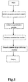
Fig. 1 is a network structure diagram of a deep learning algorithm according to an embodiment of the present disclosure; -
Fig. 2 is a structural diagram of a residual network of a feature extraction network module according to an embodiment of the present disclosure; -
Fig. 3 is a structural diagram of a feature pyramid network of a feature extraction network module according to an embodiment of the present disclosure; -
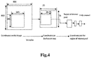
Fig. 4 is a schematic flowchart of an instance segmentation module according to an embodiment of the present disclosure; and -
Fig. 5 is a structural diagram of an antenna candidate box module according to an embodiment of the present disclosure. - Referring to
Fig. 1 , an antenna downtilt angle measuring method based on a deep instance segmentation network is disclosed in an embodiment of the present disclosure, including: shooting an omni-directional antenna video using a drone; and transmitting the antenna video to a server in real time, and the server measuring an antenna downtilt angle in real time using a deep learning algorithm, wherein the deep learning algorithm includes: a feature extraction network module for acquiring an antenna feature image; an instance segmentation module for binary segmentation of an antenna image and the background to distinguish antenna image pixels from background pixels; an antenna candidate box module for identifying and detecting the antenna image, acquiring an antenna candidate box and determining an antenna calibration box therefrom; and an antenna downtilt angle measuring module for measuring an antenna downtilt angle. - In an embodiment, the shooting an omni-directional antenna video using a drone includes: controlling the drone to fly around in a circle with an antenna as the origin and a radius of r meters from the antenna at a height of h meters from the antenna, and shooting a 360-degree omni-directional antenna video, wherein h is 10, and r is 10.
- In an embodiment, the feature extraction network module includes a residual network for solving gradient problems and network performance degradation problems and a feature pyramid network for solving multi-scale detection problems.
- Referring to
Fig. 2 , in a deep learning network, the "level" of features will increase as the depth of the deep learning network deepens, so the depth of the deep learning network is an important factor to achieve a good feature extraction effect. However, the gradual deepening of the network depth will be accompanied by gradient disappearance and gradient explosion and other problems. The conventional solution is to initialize and regularize data, which solves the gradient problems but leads to problems of performance degradation and an increased error rate of the deep learning network. The use of the residual network can solve the gradient problems as well as the problem of performance degradation of the deep learning network. - Referring to
Fig. 3 , the feature pyramid network is designed with a top-down and horizontally connected structure to combine a shallow layer with high resolution and a deep layer with rich semantic information. The top-down structure first samples an antenna feature map in a deeper layer with stronger semantics, and then connects the sampled antenna feature horizontally to a feature layer in the previous layer, thus reinforcing the antenna feature in the higher layer. The feature pyramid network can quickly construct a feature pyramid with strong semantic information at all scales from a single-scale input antenna image without a significant cost. With simple network connection changes, the performance of antenna object detection is greatly improved without increasing the calculation amount of the original model. - Referring to
Fig. 4 , in an embodiment, the instance segmentation module includes: directly mapping a region of interest to a feature map; segmenting a candidate region into k∗k cells, determining, for each cell, four fixed coordinate positions of the center point of the cell, and calculating values of the four fixed coordinate positions by bilinear interpolation; and performing max-pooling and implementing back propagation.
a back propagation formula of the instance segmentation module is
- Referring to
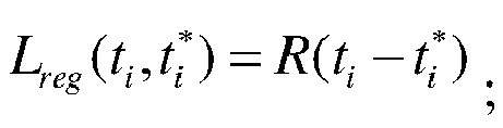
Fig. 5 , in an embodiment, preferably, the antenna candidate box module is a candidate box selection module using a faster RCNN network structure. - Further, the antenna candidate box module finally classifies and regresses the selected candidate box, its target loss function is



- Further, the antenna downtilt angle measuring module obtains a region with a minimum relative proportion by comparing a relative proportion between the antenna calibration box and a region represented by the antenna image pixels.
- Preferably, the antenna downtilt angle measuring module measures the antenna downtilt angle based on the following formula:

- The above are merely preferred embodiments of the present disclosure, and the present disclosure is not limited to the above implementations. All implementations shall be encompassed in the protection scope of the present disclosure as long as they achieve the technical effect of the present disclosure with the same means.
Claims (8)
- A method for measuring an antenna downtilt angle based on a deep instance segmentation network, comprising:shooting an omni-directional antenna video using a drone; andtransmitting the antenna video to a server in real time, and the server measuring an antenna downtilt angle in real time using a deep learning algorithm,wherein the deep learning algorithm comprises: a feature extraction network module for acquiring an antenna feature image; an instance segmentation module for binary segmentation of an antenna image and the background to distinguish antenna image pixels from background pixels; an antenna candidate box module for identifying and detecting the antenna image, acquiring an antenna candidate box and determining an antenna calibration box therefrom; and an antenna downtilt angle measuring module for measuring an antenna downtilt angle; andthe instance segmentation module comprises: directly mapping a region of interest to a feature map; segmenting a candidate region into k∗k cells, determining, for each cell, four fixed coordinate positions of the center point of the cell, and calculating values of the four fixed coordinate positions using bilinear interpolation; and performing max-pooling and implementing back propagation.
- The method for measuring an antenna downtilt angle based on a deep instance segmentation network according to claim 1, wherein the shooting an omni-directional antenna video using a drone comprises: controlling the drone to fly around in a circle with an antenna as the origin and a radius of r meters from the antenna at a height of h meters from the antenna, and shooting a 360-degree omni-directional antenna video.
- The method for measuring an antenna downtilt angle based on a deep instance segmentation network according to claim 2, wherein the feature extraction network module comprises a residual network for solving gradient problems and network performance degradation problems and a feature pyramid network for solving multi-scale detection problems.
- The method for measuring an antenna downtilt angle based on a deep instance segmentation network according to claim 1, wherein the back propagation formula of the instance segmentation module is

- The method for measuring an antenna downtilt angle based on a deep instance segmentation network according to claim 1, wherein the antenna candidate box module is a candidate box selection module using a faster RCNN network structure.
- The method for measuring an antenna downtilt angle based on a deep instance segmentation network according to claim 5, wherein the antenna candidate box module's target loss function is

 Lreg is a regression loss function, and its expression is:
 an R function is defined as Smooth
- The method for measuring an antenna downtilt angle based on a deep instance segmentation network according to claim 1, wherein the antenna downtilt angle measuring module obtains a region with a minimum relative proportion by comparing a relative proportion between the antenna calibration box and a region represented by the antenna image pixels.
- The method for measuring an antenna downtilt angle based on a deep instance segmentation network according to claim 7, wherein the antenna downtilt angle measuring module measures the antenna downtilt angle based on the following formula:

Applications Claiming Priority (2)
| Application Number | Priority Date | Filing Date | Title |
|---|---|---|---|
| CN201811317915.XA CN109579774B (en) | 2018-11-06 | 2018-11-06 | An Antenna Downtilt Measurement Method Based on Deep Instance Segmentation Network |
| PCT/CN2019/076719 WO2020093631A1 (en) | 2018-11-06 | 2019-03-01 | Antenna downtilt angle measurement method based on depth instance segmentation network |
Publications (2)
| Publication Number | Publication Date |
|---|---|
| EP3683540A1 true EP3683540A1 (en) | 2020-07-22 |
| EP3683540A4 EP3683540A4 (en) | 2021-01-20 |
Family
ID=65921618
Family Applications (1)
| Application Number | Title | Priority Date | Filing Date |
|---|---|---|---|
| EP19870064.3A Withdrawn EP3683540A4 (en) | 2018-11-06 | 2019-03-01 | METHOD OF MEASURING THE LOWERING ANGLE OF AN ANTENNA BASED ON DEEP INSTANCE SEGMENTATION NETWORK |
Country Status (4)
| Country | Link |
|---|---|
| US (1) | US11145082B2 (en) |
| EP (1) | EP3683540A4 (en) |
| CN (1) | CN109579774B (en) |
| WO (1) | WO2020093631A1 (en) |
Families Citing this family (6)
| Publication number | Priority date | Publication date | Assignee | Title |
|---|---|---|---|---|
| WO2020222985A1 (en) * | 2019-04-30 | 2020-11-05 | The Trustees Of Dartmouth College | System and method for attention-based classification of high-resolution microscopy images |
| CN112187387A (en) * | 2020-09-22 | 2021-01-05 | 北京邮电大学 | Novel reinforcement learning method based on rasterization user position automatic antenna parameter adjustment |
| CN114359376B (en) * | 2021-12-27 | 2025-11-21 | 浙江华睿科技股份有限公司 | Package positioning method, package positioning device, electronic equipment and storage medium |
| CN116758147B (en) * | 2022-03-02 | 2025-11-11 | 上海交通大学 | Plate-shaped antenna downward inclination angle measurement method and system based on mobile phone information fusion |
| CN115248025B (en) * | 2022-06-10 | 2023-06-02 | 南京工业大学 | Crane load swing angle measurement method based on self-adaptive algorithm |
| CN116052003B (en) * | 2023-02-07 | 2024-05-14 | 中科星图数字地球合肥有限公司 | Method and device for measuring antenna angle information and related equipment |
Family Cites Families (22)
| Publication number | Priority date | Publication date | Assignee | Title |
|---|---|---|---|---|
| DE10104564C1 (en) * | 2001-02-01 | 2002-09-19 | Kathrein Werke Kg | Control device for setting a different drop angle, in particular of mobile radio antennas belonging to a base station, and an associated antenna and method for changing a drop angle |
| AT511191B1 (en) * | 2011-07-01 | 2012-10-15 | Thomas Dr Neubauer | METHOD AND DEVICE FOR DETERMINING AND STORING THE POSITION AND ORIENTATION OF ANTENNA STRUCTURES |
| CN103686767B (en) * | 2013-12-12 | 2017-10-17 | 上海大唐移动通信设备有限公司 | A kind of Downtilt method of adjustment and device based on LTE network |
| US9684069B2 (en) * | 2014-01-10 | 2017-06-20 | Raytheon Company | High angular resolution low frequency radar with small antenna and high resolution low frequency ground penetrating radar |
| US10866302B2 (en) * | 2015-07-17 | 2020-12-15 | Origin Wireless, Inc. | Method, apparatus, and system for wireless inertial measurement |
| CN204101033U (en) * | 2014-10-29 | 2015-01-14 | 上海朗尚科贸有限公司 | A kind of antenna for base station angle of declination dynamic measurement system |
| US20160255471A1 (en) * | 2015-02-27 | 2016-09-01 | Qualcomm Incorporated | Distribution and utilization of antenna information for location determination operations |
| US9565649B2 (en) * | 2015-02-27 | 2017-02-07 | Qualcomm Incorporated | Distribution and utilization of antenna information for location determination operations |
| CN107664491B (en) * | 2016-07-28 | 2020-06-05 | 中国电信股份有限公司 | Method, device and system for measuring downward inclination angle of base station antenna |
| CN106658531B (en) * | 2016-10-10 | 2020-10-30 | 广东南方电信规划咨询设计院有限公司 | Method for obtaining construction parameters of 4G communication base station |
| CN106454879A (en) * | 2016-10-28 | 2017-02-22 | 中睿通信规划设计有限公司 | Method and system for determining working parameters of wireless base station based on unmanned aerial vehicle aerial shots |
| CN106651877B (en) * | 2016-12-20 | 2020-06-02 | 北京旷视科技有限公司 | Instance segmentation method and apparatus |
| US10360732B2 (en) * | 2017-03-23 | 2019-07-23 | Intel Corporation | Method and system of determining object positions for image processing using wireless network angle of transmission |
| CN107576303A (en) * | 2017-09-26 | 2018-01-12 | 张广河 | The device of telemeasurement aerial angle |
| CN107830846B (en) * | 2017-09-30 | 2020-04-10 | 杭州艾航科技有限公司 | Method for measuring angle of communication tower antenna by using unmanned aerial vehicle and convolutional neural network |
| CN108460411B (en) * | 2018-02-09 | 2021-05-04 | 北京市商汤科技开发有限公司 | Instance division method and apparatus, electronic device, program, and medium |
| US11391819B2 (en) * | 2018-07-18 | 2022-07-19 | Qualcomm Incorporate | Object verification using radar images |
| CN109458980B (en) * | 2018-11-06 | 2021-01-26 | 五邑大学 | Antenna downward inclination angle measurement method based on linear regression fitting |
| CN109458978B (en) * | 2018-11-07 | 2020-12-01 | 五邑大学 | An Antenna Downtilt Angle Measurement Method Based on Multi-scale Detection Algorithm |
| CN109685762A (en) * | 2018-11-09 | 2019-04-26 | 五邑大学 | A kind of Downtilt measurement method based on multiple dimensioned deep semantic segmentation network |
| US11074707B2 (en) * | 2019-08-13 | 2021-07-27 | Wuyi University | Method and system of antenna measurement for mobile communication base station |
| US11468266B2 (en) * | 2019-09-27 | 2022-10-11 | Raytheon Company | Target identification in large image data |
-
2018
- 2018-11-06 CN CN201811317915.XA patent/CN109579774B/en active Active
-
2019
- 2019-03-01 US US16/966,604 patent/US11145082B2/en not_active Expired - Fee Related
- 2019-03-01 EP EP19870064.3A patent/EP3683540A4/en not_active Withdrawn
- 2019-03-01 WO PCT/CN2019/076719 patent/WO2020093631A1/en not_active Ceased
Also Published As
| Publication number | Publication date |
|---|---|
| WO2020093631A1 (en) | 2020-05-14 |
| CN109579774B (en) | 2021-04-23 |
| US11145082B2 (en) | 2021-10-12 |
| US20210056722A1 (en) | 2021-02-25 |
| CN109579774A (en) | 2019-04-05 |
| EP3683540A4 (en) | 2021-01-20 |
Similar Documents
| Publication | Publication Date | Title |
|---|---|---|
| EP3683540A1 (en) | Antenna downtilt angle measurement method based on depth instance segmentation network | |
| US11561092B2 (en) | Method for measuring antenna downtilt angle based on multi-scale deep semantic segmentation network | |
| CN111551927B (en) | Underground pipeline diameter measuring method based on three-dimensional ground penetrating radar | |
| CN102768022B (en) | Tunnel surrounding rock deformation detection method adopting digital camera technique | |
| EP3683541A1 (en) | Method for measuring downward inclination angle of antenna based on linear regression fitting | |
| US11145089B2 (en) | Method for measuring antenna downtilt based on multi-scale detection algorithm | |
| CN109799503A (en) | Building Damage assessment drafting method and system | |
| CN114139566A (en) | Method for improving accuracy of measurement based on machine learning weighted average fusion feature extraction | |
| US20250371718A1 (en) | Method for measuring channel flow based on bionic eagle-eye vision and apparatus thereof | |
| CN120762035B (en) | A method and apparatus for horizontal wind field inversion based on radial velocity of wind profiler radar | |
| CN119064720B (en) | Accurate positioning system of cable trouble | |
| CN117808287A (en) | A comprehensive assessment method for potential risks of overhead lines | |
| CN110427696B (en) | Tunnel Lidar point cloud primary support surface early warning method suitable for different sections | |
| CN111505649A (en) | Towed passive array sonar low signal-to-noise ratio ship moving target detection method | |
| CN121028077A (en) | A method and system for detecting underground pipeline distribution based on ground penetrating radar | |
| CN117074869B (en) | Distribution line fault positioning method and system | |
| CN108414997A (en) | A kind of Boundary Layer Height inversion method based on particle properties difference | |
| CN109341650B (en) | Unmanned aerial vehicle elevation error double-threshold correction method based on minimum detection cost | |
| CN115601338A (en) | A method for detecting soil layering at the base of a transmission line tower and related equipment | |
| CN113534296A (en) | Calculation method and device for intensity error of sand and dust weather forecast based on neural network | |
| CN116935050B (en) | A method and system for ground segmentation using lidar | |
| CN119024268B (en) | High-precision signal time difference direction finding positioning method and system combined with dual-path vision pod spatial positioning | |
| CN120182895B (en) | Method for intelligently intercepting tide to video and identifying tide level change at high frequency at rear end | |
| CN118112545B (en) | Atmospheric laser radar reference height extraction method and system based on Rayleigh fitting | |
| CN114429586B (en) | A scene detection benchmark model training method, system and application method |
Legal Events
| Date | Code | Title | Description |
|---|---|---|---|
| STAA | Information on the status of an ep patent application or granted ep patent |
Free format text: STATUS: UNKNOWN |
|
| STAA | Information on the status of an ep patent application or granted ep patent |
Free format text: STATUS: THE INTERNATIONAL PUBLICATION HAS BEEN MADE |
|
| PUAI | Public reference made under article 153(3) epc to a published international application that has entered the european phase |
Free format text: ORIGINAL CODE: 0009012 |
|
| STAA | Information on the status of an ep patent application or granted ep patent |
Free format text: STATUS: REQUEST FOR EXAMINATION WAS MADE |
|
| 17P | Request for examination filed |
Effective date: 20200416 |
|
| AK | Designated contracting states |
Kind code of ref document: A1 Designated state(s): AL AT BE BG CH CY CZ DE DK EE ES FI FR GB GR HR HU IE IS IT LI LT LU LV MC MK MT NL NO PL PT RO RS SE SI SK SM TR |
|
| AX | Request for extension of the european patent |
Extension state: BA ME |
|
| A4 | Supplementary search report drawn up and despatched |
Effective date: 20201222 |
|
| RIC1 | Information provided on ipc code assigned before grant |
Ipc: G06T 7/70 20170101ALI20201216BHEP Ipc: G01C 1/00 20060101AFI20201216BHEP Ipc: G01C 11/04 20060101ALI20201216BHEP Ipc: G06N 3/08 20060101ALI20201216BHEP Ipc: G06T 7/00 20170101ALI20201216BHEP |
|
| STAA | Information on the status of an ep patent application or granted ep patent |
Free format text: STATUS: THE APPLICATION IS DEEMED TO BE WITHDRAWN |
|
| 18D | Application deemed to be withdrawn |
Effective date: 20210730 |