EP3671546A1 - Method and system for determining landmarks in an environment of a vehicle - Google Patents
Method and system for determining landmarks in an environment of a vehicle Download PDFInfo
- Publication number
- EP3671546A1 EP3671546A1 EP19217199.9A EP19217199A EP3671546A1 EP 3671546 A1 EP3671546 A1 EP 3671546A1 EP 19217199 A EP19217199 A EP 19217199A EP 3671546 A1 EP3671546 A1 EP 3671546A1
- Authority
- EP
- European Patent Office
- Prior art keywords
- subset
- landmark
- data
- environmental data
- unit
- Prior art date
- Legal status (The legal status is an assumption and is not a legal conclusion. Google has not performed a legal analysis and makes no representation as to the accuracy of the status listed.)
- Pending
Links
Images

Classifications
-
- G—PHYSICS
- G06—COMPUTING; CALCULATING OR COUNTING
- G06F—ELECTRIC DIGITAL DATA PROCESSING
- G06F18/00—Pattern recognition
- G06F18/20—Analysing
- G06F18/24—Classification techniques
-
- G—PHYSICS
- G06—COMPUTING; CALCULATING OR COUNTING
- G06V—IMAGE OR VIDEO RECOGNITION OR UNDERSTANDING
- G06V20/00—Scenes; Scene-specific elements
- G06V20/50—Context or environment of the image
- G06V20/56—Context or environment of the image exterior to a vehicle by using sensors mounted on the vehicle
-
- G—PHYSICS
- G01—MEASURING; TESTING
- G01C—MEASURING DISTANCES, LEVELS OR BEARINGS; SURVEYING; NAVIGATION; GYROSCOPIC INSTRUMENTS; PHOTOGRAMMETRY OR VIDEOGRAMMETRY
- G01C21/00—Navigation; Navigational instruments not provided for in groups G01C1/00 - G01C19/00
- G01C21/26—Navigation; Navigational instruments not provided for in groups G01C1/00 - G01C19/00 specially adapted for navigation in a road network
- G01C21/28—Navigation; Navigational instruments not provided for in groups G01C1/00 - G01C19/00 specially adapted for navigation in a road network with correlation of data from several navigational instruments
- G01C21/30—Map- or contour-matching
-
- G—PHYSICS
- G06—COMPUTING; CALCULATING OR COUNTING
- G06F—ELECTRIC DIGITAL DATA PROCESSING
- G06F18/00—Pattern recognition
- G06F18/20—Analysing
- G06F18/21—Design or setup of recognition systems or techniques; Extraction of features in feature space; Blind source separation
- G06F18/214—Generating training patterns; Bootstrap methods, e.g. bagging or boosting
-
- G—PHYSICS
- G06—COMPUTING; CALCULATING OR COUNTING
- G06V—IMAGE OR VIDEO RECOGNITION OR UNDERSTANDING
- G06V10/00—Arrangements for image or video recognition or understanding
- G06V10/70—Arrangements for image or video recognition or understanding using pattern recognition or machine learning
- G06V10/82—Arrangements for image or video recognition or understanding using pattern recognition or machine learning using neural networks
-
- G—PHYSICS
- G06—COMPUTING; CALCULATING OR COUNTING
- G06V—IMAGE OR VIDEO RECOGNITION OR UNDERSTANDING
- G06V20/00—Scenes; Scene-specific elements
- G06V20/10—Terrestrial scenes
-
- G—PHYSICS
- G06—COMPUTING; CALCULATING OR COUNTING
- G06V—IMAGE OR VIDEO RECOGNITION OR UNDERSTANDING
- G06V20/00—Scenes; Scene-specific elements
- G06V20/50—Context or environment of the image
- G06V20/56—Context or environment of the image exterior to a vehicle by using sensors mounted on the vehicle
- G06V20/58—Recognition of moving objects or obstacles, e.g. vehicles or pedestrians; Recognition of traffic objects, e.g. traffic signs, traffic lights or roads
- G06V20/582—Recognition of moving objects or obstacles, e.g. vehicles or pedestrians; Recognition of traffic objects, e.g. traffic signs, traffic lights or roads of traffic signs
-
- G—PHYSICS
- G06—COMPUTING; CALCULATING OR COUNTING
- G06V—IMAGE OR VIDEO RECOGNITION OR UNDERSTANDING
- G06V2201/00—Indexing scheme relating to image or video recognition or understanding
- G06V2201/08—Detecting or categorising vehicles
-
- G—PHYSICS
- G06—COMPUTING; CALCULATING OR COUNTING
- G06V—IMAGE OR VIDEO RECOGNITION OR UNDERSTANDING
- G06V2201/00—Indexing scheme relating to image or video recognition or understanding
- G06V2201/09—Recognition of logos
Definitions
- the present invention relates to a method for determining landmarks in the surroundings of a vehicle. It also relates to a system for determining landmarks in the surroundings of a vehicle.
- Modern vehicles include a variety of driving functions that allow certain driving tasks to be carried out at least partially automatically.
- An essential prerequisite for this is a precise knowledge of the surroundings of the vehicle, in particular its position relative to objects that are relevant for the control.
- a variety of different sensors can be used to capture this knowledge.
- the evaluation of the data to be processed in this way continues to be a major challenge in known systems.
- WO 2018/104563 A2 a method for video-based position determination is known, semantic segmentation being carried out. Objects are identified and used to detect landmarks. Visual odometry is performed.
- the US 2018/0089505 A1 proposes a method for object detection in an image, in which probabilities for the identification of certain object candidates are determined. Scaling and determining threshold values for these probabilities are intended to prevent false detections.
- the present invention has for its object to provide a method and a system that allows a particularly efficient determination of landmarks.
- first environmental data are recorded. At least a subset of the first environmental data is determined and the subset is assigned a category from a large number of different categories. Depending on a landmark type, a category is determined and landmark detection is carried out, which is limited to the subset of the particular category.
- the landmark detection is advantageously carried out particularly quickly and with optimal use of the resources in the vehicle. Furthermore, false detections can be avoided and the output data for the detection of landmarks can be optimized for the implementation of the detection. The method also ensures improved maintainability and testability, since incorrect landmark detection can be avoided in unsuitable areas.
- the occurrence of landmarks is not searched for when determining the subset of the first environmental data, but areas can be determined and categorized, for example, in which specific types of landmarks are to be sought or are not to be expected.
- the term “landmarks” includes features and / or patterns in an environment that can be identified and to which at least location information can be assigned. These can be, for example, characteristic points or objects that are arranged at certain positions in the environment.
- the landmarks can have semantics, that is to say they can also be identified as such for human perception as identifiable objects or features. Landmarks are also included that do not have any semantics, but rather represent, for example, abstract patterns that can be detected by pattern recognition.
- Landmark types can be assigned to the landmarks in a manner known per se, in particular on the basis of geometric properties or on the basis of a semantics which are connected to the landmarks. For example, lane markings, posts, signs, structures, elements of vegetation or structures of traffic management systems can each be defined as specific types of landmarks. Furthermore, several special types of landmarks, such as “stop signs” and “no parking signs”, can be assigned to a more general or generic type of landmark, such as “signs”. In particular, the Process associated with each landmark at least one landmark type. A specific landmark can also be assigned to several special and / or general landmark types.
- Landmark types can be, for example, edges or other parts of structures, markings on a roadway, traffic guidance devices or two-dimensional codes. For example, lane markings, turning arrows, parking space markings or similar floor markings, posts, poles, columns, traffic or other signs, signaling systems or traffic lights, building edges or corners, pipes, QR or barcodes as well as alphanumeric representations can be detected.
- further features can be used for localization, which designate characteristic, localizable points in a geographical environment of the own position. In general, these are features that can be identified using a pattern recognition method and to which position data can be assigned.
- the first environmental data are recorded using a camera.
- existing devices of the vehicle can advantageously be used to record relevant environmental data.
- the camera captures image data, in particular as a chronologically ordered sequence of individual images, which can be combined to form video data.
- the environmental data can also be recorded in another manner known per se, for example by means of sensors of a vehicle such as optical, radar, lidar or ultrasonic sensors.
- This can be, for example, a permanently installed sensor for traffic monitoring that records and provides environmental data.
- an external server can be used, which receives, stores and provides relevant environmental data if required.
- Such environmental data can, for example, be recorded by certain or a large number of vehicles and devices along a route and transmitted to the server.
- radar sensors are sensors of a first type and ultrasound sensors are sensors of another type.
- a further differentiation can be made, for example a differentiation between different ones Types of radar sensors that differ from one another, for example, in their construction and / or a special type of data processing.
- the environmental data are also recorded in a specific detection area, which can be caused in particular by the sensor type and / or a specific activation of the sensors.
- the detection space can be defined, for example, by an angle in space and a distance or radius relative to the vehicle.
- a plurality of sensors, in particular of a common sensor type, can furthermore be used in combination in order to arrive at an enlarged detection space by combining the recorded environmental data.
- a camera can capture image data from a certain point of view and a combination of several cameras can cover a larger detection area and, for example, enable an all-round view of the vehicle.
- the landmark detection is limited to a subset of the acquired first environmental data and the volume of the environmental data to be analyzed is reduced in this way.
- a semantic segmentation of the recorded first environmental data can be carried out, in which a classification is carried out for subsets of the environmental data and a category is assigned to them.
- classification is made for each pixel of captured image data. Pixels that are assigned to a common category can be combined into individual subsets or segments, especially if they form a coherent surface.
- the subset is determined by means of a machine learning method.
- the determination of the subset and possibly also the assignment of a category can advantageously be implemented in a particularly flexible and reliable manner.
- a trained classifier is used, which is designed on the basis of training data for recognizing certain categories on the basis of the recorded environmental data.
- Methods known per se from the field of machine learning or artificial intelligence are used, for example a neural network, a deep learning system or a suitable statistical method.
- the categories include a floor, a roadway, vegetation, a built-up area, a pillar, a standing or moving vehicle or a person.
- the categories therefore essentially correspond to object classes.
- the categories assigned to the subsets are therefore advantageously particularly well suited to determining suitable subsets of the environmental data for detecting certain types of landmarks.
- the landmark detection is carried out using a heuristic procedure.
- the detection is advantageously carried out in a known and safe manner on the basis of predetermined detector modules which include a reliably recognizable characterization of the landmarks.
- the detection takes place in particular on the basis of fixed, predetermined rules for the detection of certain features of landmarks of a specific landmark type.
- Landmarks of a certain type of landmark can be described using a pattern which is suitable for detecting a landmark of the particular type of landmark in surrounding data.
- the information used for this can include, for example, a mathematically formulated description for recognizing a pattern with which a landmark or a feature of the environment is represented in the signals of a sensor.
- geometric properties of objects of a landmark type can be described, but also material properties, such as reflectance values or mathematical functions, such as gradients of light-dark transitions.
- Such descriptions for the detection of landmarks of a landmark type are generally sensor-specific, so that it is sensible for the different types of sensors to be provided with their own pattern descriptions for the detection.
- the detection of patterns in an image of an optical camera differs from the detection within a point cloud that a laser scanner detects.
- the data recorded by a specific sensor type can be processed in such a way that the same detection method as for data of another sensor type can be applied to them.
- the landmarks are detected on the basis of the surrounding data, for example using pattern recognition methods, by means of which the landmarks are used, for example, in camera images or laser point clouds can be recognized.
- So-called “detector modules” are used for this. These are, in particular, software modules that include, for example, a storable file.
- the detector modules are designed in such a way that they can be used to detect landmarks of a specific landmark type based on the recorded environmental data. In particular, the detector modules can be designed specifically for the detection of a specific landmark type. It can be provided that each detected landmark is assigned at least one landmark type.
- a rough classification of areas within the environmental data is first carried out, in particular using a method of artificial intelligence, in which landmarks of a specific landmark type can then be specifically detected, a heuristic method being used in particular for the detection .
- other subsets can be excluded on the basis of the categories assigned to them when detecting the landmarks for a particular landmark type, for example because no occurrence of a particular landmark is to be expected in certain areas of the environmental data.
- the subset therefore corresponds in particular to a selected area, for example a so-called region of interest (ROI) for the search for landmarks of a specific landmark type.
- ROI region of interest
- landmarks of the "lane markings” landmark type are expected on a lane, that is to say in a subset of the surrounding data, which belongs, for example, to the "lane” category. Conversely, landmarks of this type of landmark are not expected in areas that have been categorized as "stationary vehicle", for example. In this way, for example, false detections due to reflections of a landmark can be avoided.
- a spatial area in the surroundings of the vehicle is determined on the basis of the determined subset, and further ambient data are recorded on surfaces, wherein a different sensor type is used to record the further environmental data than for recording the first environmental data.
- the landmark detection is also carried out on the basis of the further environmental data and as a function of the spatial area. This advantageously makes it possible to also use the information obtained on the basis of the first environmental data for environmental data acquired by other sensors.
- image data are acquired as the first environmental data.
- a subset is initially determined and assigned to a category in such a way that a specific landmark type is detected on the basis of this subset.
- the subset corresponds to a spatial area in the vehicle environment in which data is also acquired using other sensors of a different sensor type. For example, data from a lidar sensor can be recorded there.
- filtering can now be carried out in such a way that the landmark detection is limited to the same spatial area on the basis of the lidar data or that further spatial areas are covered by the landmark detection be exempted.
- the additional environmental data are only recorded in the spatial area, for example by controlling a detection unit of the other sensor type in such a way that the detection is limited to the spatial area.
- the amount of data obtained can advantageously be reduced.
- computing times and latency times when data is transferred, for example inside the vehicle or to an external unit, are reduced.
- spatial areas can also be stored over a longer period of time and used when acquiring the additional environmental data, for example in further time steps.
- a detection area of a sensor or the area relevant for the detection of a specific landmark type can be stored by a control device of the sensor and used for filtering the detected data.
- the subset is transmitted from a mobile unit, in particular from the vehicle, to an external unit and the landmark detection is carried out by the external unit.
- the external unit can be, for example, an external server or be a back-end device that is data-technically coupled to the mobile unit.
- the landmark detection can advantageously be carried out by a unit which has larger resources than the mobile unit.
- the method of the invention enables a considerable reduction in the data to be transmitted, since only the subset of a suitable category has to be transmitted for the landmark detection. This means that the available bandwidth can be used particularly efficiently, especially when transmitting data via radio waves.
- the external unit can also have continuously updated detectors for different types of landmarks and therefore also allow, for example, the detection of such landmarks for which a complex software update would otherwise have to be carried out in the mobile unit.
- request data are generated by the external unit and the subset is transmitted to the external unit depending on the request data.
- the external unit can advantageously request the required data in a targeted manner.
- the request data include in particular information about a category on the basis of which the subset to be transferred is formed.
- the external unit can first define a specific landmark type for which a landmark detection is to be carried out, and the suitable data can be requested from the mobile unit by the request data.
- position data for landmarks of the landmark type are determined and output in the landmark detection.
- a pose of the vehicle is determined on the basis of the position data. The determination of such a pose is, for example, a prerequisite for performing a partially or fully automatic travel of the vehicle.
- Position data are assigned to the detected landmarks, in particular a position or a pose in a coordinate system being assigned to the landmarks. This can be done in the detection step or in a separate step.
- the position or pose can be determined in particular as a function of the assigned landmark type, for example by defining specific axes for determining the position of the landmark for certain landmark types or by using certain sections of a landmark to determine the position of the landmark.
- a global or relative coordinate system are used, for example a relative system relative to a detection unit or a vehicle.
- further features can be determined for the detected landmarks, such as their size and shape, color, a parameter for describing dynamic features, or by evaluating a label.
- the pose of the vehicle includes information about its position and orientation in a particular coordinate system, such as a global coordinate system or a relative coordinate system.
- map data are recorded, which also include position data for the landmarks, that is, information about their position in a coordinate system. It can be a global or relative coordinate system.
- the position data relate in particular to poses of the landmarks, that is to say a combination of their position and their position, described, for example, on the basis of their orientation relative to other landmarks.
- an arrow can point in a certain direction in space
- a post can have a certain length and run at a certain angle to a carriageway
- an edge of a building can be in a certain position relative to a carriageway.
- a transformation is determined by means of which the positions of the landmarks in the vehicle system can be transformed into the coordinate system of the map data. This transformation results in the position and in particular also the orientation of the vehicle in the coordinate system of the map data.
- the landmark detection is carried out using a machine learning process.
- Machine learning is advantageously used not only to determine the subset, but also to detect the landmarks. By performing the landmark detection on the basis of the subset of the surrounding data, machine learning can also be restricted to smaller amounts of data.
- a training is carried out on the basis of example data sets, in which the system automatically learns to recognize certain patterns for individual landmarks. Unlike a heuristic method, no fixed systems of rules for recognizing the landmarks are specified here, but the detection is based on the data records for the training.
- the method is also carried out in two stages if both the determination of the subset and the landmark detection are carried out using a machine learning method: First, the segmentation of the environmental data is carried out, combined with the assignment of categories to subsets of the environmental data. The landmark detection is then carried out, taking into account only those subsets to which suitable categories for the landmark types to be detected have been assigned.
- training data are generated on the basis of the subset and a training for the landmark detection is carried out on the basis of the machine learning method on the basis of the training data.
- the training can thus advantageously take place in a particularly targeted manner.
- the training can be carried out, for example, by an external unit, which carries out the landmark detection.
- the categorization of the subsets of the environmental data makes it easier to provide relevant training data.
- the automatic detection of the landmarks can be further improved in this way.
- detector modules for landmarks of a specific landmark type can be generated or updated on the basis of the training data.
- the landmark detection can then again be carried out in a different way than a machine learning method, in particular using a heuristic method.
- the detector modules can in particular be completely newly generated by machine learning, in particular in order to be able to detect new types of landmarks, or an improved detector module can be generated.
- a sliding window method can be used for landmark detection, in which a "window" is used to rasterize the surrounding data to detect the landmarks.
- the size and, if necessary, also the shape of such a window must be such that the landmarks to be detected can be found therein.
- the system according to the invention of the type mentioned at the outset comprises a recording unit for recording first environmental data and a segmentation unit for determining at least a subset of the first environmental data and for assigning a category from a large number of different categories to the specific subset.
- the system further comprises an arithmetic unit for determining a category depending on a landmark type and for performing a landmark detection for the landmark type.
- the computing unit is set up to carry out the landmark detection restricted to the subset of the specific category.
- the system according to the invention is particularly designed to implement the method according to the invention described above.
- the system thus has the same advantages as the method according to the invention.
- the detection unit comprises a camera.
- sensors can be provided, for example based on radar, lidar, ultrasound or various optical sensors, for example infrared, time-of-flight or stereo cameras.
- sensor systems already widely used in vehicles can advantageously be used.
- a spatial area is determined on the basis of the determined subset and the environmental data recorded by the detection unit is filtered.
- it is determined in particular which subsets of environmental data that have been recorded by other sensor types correspond to the specific spatial area for the subsets.
- a spatial area is determined on the basis of image data, for which a lidar sensor also records ambient data.
- the environmental data of the further sensor type can also be filtered so that the environmental data recorded there can be used for the landmark detection. In contrast, environmental data recorded in other areas can be rejected.
- a control device controls the segmentation unit in such a way that only the subset of the recorded environmental data is transmitted to the computing unit.
- several subsets which are determined for a landmark type on the basis of the categories assigned to them, are transmitted to the computing unit.
- the control device comprises the segmentation device and already determines the subset on the level of the detection and the sensors used for this purpose.
- the system further comprises an interface to an external unit and the system is set up to transmit the specific subset to the external unit, the external unit being set up to carry out the landmark detection on the basis of the subset.
- the external unit then transmits information about detected landmarks to the interface.
- the complex step of landmark detection can thereby advantageously be carried out by the external unit, for example an external server. Determining a relevant subset of the environmental data helps to ensure that as little data as possible has to be transmitted via the interface, so that the available bandwidth can be used particularly efficiently.
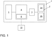
- the vehicle 1 comprises a detection unit 2 with a camera 2a and a lidar unit 2b.
- the detection unit is coupled to a segmentation unit 3, which in turn is coupled to a computing unit 4.
- the vehicle 1 also includes a driver assistance system 5, which is also coupled to the computing unit 4.
- the computing unit also comprises an interface 6, via which a separable, wireless data connection to an external unit 10 can be established.
- the interface 6 is set up in a manner known per se to establish a connection to a network, in particular the Internet, via a mobile radio network via a mobile radio network.
- the external unit 10 is designed as a back-end server.
- the segmentation unit 3 is comprised by a control unit of the detection unit 2 and in particular integrated into the detection unit 2.
- a control device can also be formed integrally with the camera 2a and / or the lidar unit 2b.
- the segmentation unit 3 is designed to carry out a comprehensive preprocessing of the recorded environmental data before, if appropriate, a transfer to the computing unit 4 takes place.
- first environmental data are acquired by the acquisition unit 2.
- the first environmental data comprise image data that are captured by the camera 2a.
- the acquired first environmental data are transmitted to the segmentation unit 3 in a step 21.
- the segmentation unit uses the image data to determine subsets of the first environmental data.
- a machine learning method is used for this. Any suitable method from the field of artificial intelligence and neural networks can be used.
- a trained classifier is used, which was formed from training data to assign the correct categories to the pixels of the surrounding data.
- semantic segmentation is carried out for this.
- each pixel of the image data is classified and assigned to a category.
- Contiguous areas of pixels of a common category are called segments and form a common subset of the surrounding data.
- At least one category is assigned to each of these subsets.
- the categories assigned in the exemplary embodiment relate to properties of different areas in the surroundings of the vehicle 1 and indicate, for example, whether a pixel is assigned to a floor, a roadway, vegetation, a built-up area, a column, a stationary or moving vehicle or a person . Alternatively or additionally, other categories can be provided.
- the specific subsets of certain categories are transmitted from the segmentation unit 3 to the computing unit 4. This is in particular a reduced amount of data compared to the recorded environmental data. This leads to an improved utilization of the bandwidth available in vehicle 1 for the transmission of data.
- the decision for which categories the relevant subsets should be transferred depends on the types of landmarks to be determined. It can be assumed that landmarks of a certain type can be found in areas of a certain category. For example, lane markings on a lane should be recognized, but not their mirror images, for example on a reflective surface of a parked vehicle. On the other hand, traffic signs are expected in an edge area next to a road, so that the road surface is not relevant in this case and a corresponding subset can be excluded from the detection.
- the entire recorded environmental data together with information about the previously determined subsets and their categories are transmitted to the computing unit 4.
- the computing unit 4 can determine which partial quantities are to be taken into account for each landmark type to be detected.
- landmarks are determined by the computing unit 4. This is done on the basis of those subsets of the environmental data which have been assigned suitable categories for certain types of landmarks.
- detector modules are used which, in the exemplary embodiment, are designed as software modules for detecting landmarks of a specific type of landmark based on the surrounding data.
- heuristic methods are used in which the detector modules comprise a predetermined control structure for recognizing landmarks of a certain type.
- the detections can be carried out using a machine learning method or a mixture of different methods can be used, for example by using a machine learning method to generate or update a detector module.
- the following types of landmarks are provided: road markings, traffic signs, light signal systems, QR codes, posts or other features in the vicinity of the vehicle 1.
- the landmarks are detected, their type of landmarks are determined and, depending on the particular type of landmarks, characteristics of the individual landmarks are determined determined. This includes in particular position information relative to vehicle 1.
- the detection of the landmarks of a specific type of landmark is carried out only on the basis of subsets of the recorded environmental data, to which a suitable category has been assigned.
- information about the detected landmarks is transmitted to the driver assistance system 5, which in the exemplary embodiment carries out a landmark-based position determination and uses the information obtained in this way for autonomous control of the vehicle 1.
- map data are recorded, which include position information and possibly further data about landmarks in the vicinity of vehicle 1.
- a transformation is carried out, by means of which the position data of the landmarks detected by vehicle 1 are transferred into the coordinate system of the map data.
- the position of the vehicle 1 is also determined on the basis of this transformation, in particular in connection with its orientation in the coordinate system of the map data.
- information about certain relevant categories of the subsets of the environmental data is generated and transmitted to the segmentation unit 3. For example, it is determined which types of landmarks are to be detected and which categories are relevant for this.
- the partial quantities can be determined specifically for certain categories and the relevant partial quantities can be transmitted to the computing unit 4 in a targeted manner. The volume of the data to be transmitted can be reduced in this way.
- further environmental data are recorded by the lidar unit 2b.
- the information determined by the segmentation unit 3 in step 21 is now used to use this additional environmental data particularly efficiently. For this purpose, it is determined which spatial areas in the vicinity of the vehicle correspond to the subsets of the image data which the camera 2a has captured and which in step 21 were categorized. For example, on the basis of the image data captured by the camera 2a, it is determined in which spatial area, relative to the vehicle 1, the road surface or another vehicle is located. The same category is assigned to this spatial area, and when evaluating the additional environmental data that were recorded using a different sensor type, partial quantities are again determined that correspond to the spatial area.
- subsets are only carried out on the basis of the image data, while the subsets of the other environmental data recorded in the same spatial areas are assigned the same categories. Depending on the categories assigned to them, these subsets are also transmitted to the computing unit 4 and used for landmark detection.
- the landmarks are at least partially detected by the external unit 10.
- the environmental data are not completely transmitted to the external unit 10 via the interface 6, also because the bandwidth available for this is typically limited. Instead, only those subsets of the environmental data are transmitted which have been determined by the segmentation unit 3 and have been assigned to a category suitable for the desired landmarks.
- the external unit 10 can also generate request data, which for example include information about relevant categories and / or desired landmarks. These request data are received by the vehicle 1 via the interface 6 and the acquisition of the environmental data by the acquisition unit 2 and / or the generation of the subsets by the segmentation unit 3 are carried out in such a way that suitable subsets of certain categories can be provided for the desired landmarks. These suitable subsets are then transmitted to the external unit 10.
- request data for example include information about relevant categories and / or desired landmarks.
- the external unit can transmit the specific landmarks, in particular with position information, to the vehicle 1.
- the external unit 10 can carry out a position determination for the vehicle 1, for example as described above for the driver assistance system 5.
- the subsets of the environmental data are used to provide training data for a machine learning method, for example for training a classifier.
- the subsets with suitable categories are used and it is first determined in which subsets Landmarks of the desired type are available. Various learning methods known per se can then be used.
- image data are captured by means of the camera 2a.
- image data are processed by means of semantic segmentation.
- an artificial intelligence method is used and a trained classifier assigns a category to the pixels of the image data.
- the segmented image data are then fed to further image processing in a step 32 or are used to filter sensor data in a step 33.
- subsets of the recorded environmental data are generated.
- image data acquired in step 30 is assumed, but also further environmental data, which are acquired in step 34, for example by a radar or lidar sensor.
- spatial areas in the surroundings of vehicle 1 are determined on the basis of the segmented image data, and the categories assigned to the segments are also assigned to those data which are detected by other sensors in the same spatial areas.
- subsets of the recorded radar or lidar data are determined, which were recorded in the area of a roadway or another vehicle.
- filtered sensor data are generated that only comprise those subsets that are assigned to specific categories.
- the filtered sensor data are therefore particularly suitable, in particular, for the detection of certain types of landmarks, for example if only certain types of landmarks are to be detected in a specific driving situation. For example, when parking vehicle 1 automatically, parking space markings on a floor surface can be relevant as landmarks.
- the sensor data are processed further, in particular a landmark detection being carried out.
- a landmark detection positions of individual landmarks in particular in the vicinity of vehicle 1 can be determined and used to determine the position or pose of the vehicle 1.
- a support function can also be carried out, such as a parking garage pilot or a parking assistant.
- the lidar unit 2b specifically detects the additional environmental data in specific spatial areas to which specific categories are assigned and which are to be used for landmark detection.
- the sensor unit can be controlled, for example, by a control device in such a way that the detection space assigned to it is adapted in accordance with the spatial areas.
Abstract
Bei dem Verfahren zum Bestimmen von Landmarken in einer Umgebung eines Fahrzeugs (1) werden erste Umgebungsdaten erfasst und es wird zumindest eine Teilmenge der ersten Umgebungsdaten bestimmt. Der bestimmten Teilmenge wird eine Kategorie aus einer Vielzahl verschiedener Kategorien zugeordnet. In Abhängigkeit von einem Landmarkentyp eine Kategorie bestimmt und es wird eine auf die Teilmenge der bestimmten Kategorie beschränkte Landmarkendetektion für den Landmarkentyp durchgeführt. Das System zum Bestimmen von Landmarken in einer Umgebung eines Fahrzeugs (1) umfasst eine Erfassungseinheit (2) zum Erfassen erster Umgebungsdaten, eine Segmentierungseinheit (3) zum Bestimmen zumindest einer Teilmenge der ersten Umgebungsdaten und zum Zuordnen einer Kategorie aus einer Vielzahl verschiedener Kategorien zu der bestimmten Teilmenge sowie eine Recheneinheit (4) zum Bestimmen einer Kategorie in Abhängigkeit von einem Landmarkentyp und zum Durchführen einer Landmarkendetektion für den Landmarkentyp. Dabei ist die Recheneinheit dazu eingerichtet, die Landmarkendetektion auf die Teilmenge der bestimmten Kategorie beschränkt durchzuführen.

Description
Die vorliegende Erfindung betrifft ein Verfahren zum Bestimmen von Landmarken in einer Umgebung eines Fahrzeugs. Sie betrifft ferner ein System zum Bestimmen von Landmarken in einer Umgebung eines Fahrzeugs.The present invention relates to a method for determining landmarks in the surroundings of a vehicle. It also relates to a system for determining landmarks in the surroundings of a vehicle.
Moderne Fahrzeuge umfassen eine Vielzahl von Fahrfunktionen, die eine zumindest teilweise automatische Durchführung bestimmter Fahraufgaben erlauben. Eine wesentliche Voraussetzung hierfür ist ein genaues Wissen über die Umgebung des Fahrzeugs, insbesondere seine Position relativ zu Objekten, die für die Steuerung relevant sind. Um dieses Wissen zu erfassen, kann eine Vielzahl verschiedener Sensoren verwendet werden. Die Auswertung der auf diese Weise zu verarbeitenden Daten stellt bei bekannten Systemen jedoch weiterhin eine große Herausforderung dar.Modern vehicles include a variety of driving functions that allow certain driving tasks to be carried out at least partially automatically. An essential prerequisite for this is a precise knowledge of the surroundings of the vehicle, in particular its position relative to objects that are relevant for the control. A variety of different sensors can be used to capture this knowledge. However, the evaluation of the data to be processed in this way continues to be a major challenge in known systems.
In der
Aus der
Die
Der vorliegenden Erfindung liegt die Aufgabe zugrunde, ein Verfahren und ein System bereitzustellen, die eine besonders effiziente Bestimmung von Landmarken erlaubt.The present invention has for its object to provide a method and a system that allows a particularly efficient determination of landmarks.
Erfindungsgemäß wird diese Aufgabe durch ein Verfahren mit den Merkmalen des Anspruchs 1 und ein System mit den Merkmalen des Anspruchs 12 gelöst. Vorteilhafte Ausgestaltungen und Weiterbildungen ergeben sich aus den abhängigen Ansprüchen.According to the invention, this object is achieved by a method having the features of
Bei dem erfindungsgemäßen Verfahren der eingangs genannten Art werden erste Umgebungsdaten erfasst. Es wird zumindest eine Teilmenge der ersten Umgebungsdaten bestimmt und der bestimmten Teilmenge wird eine Kategorie aus einer Vielzahl verschiedener Kategorien zugeordnet. In Abhängigkeit von einem Landmarkentyp wird eine Kategorie bestimmt und es wird eine auf die Teilmenge der bestimmten Kategorie beschränkte Landmarkendetektion durchgeführt.In the method according to the invention of the type mentioned in the introduction, first environmental data are recorded. At least a subset of the first environmental data is determined and the subset is assigned a category from a large number of different categories. Depending on a landmark type, a category is determined and landmark detection is carried out, which is limited to the subset of the particular category.
Die Landmarkendetektion erfolgt dadurch vorteilhafterweise besonders schnell und unter optimaler Ausnutzung der Ressourcen im Fahrzeug. Ferner können Fehldetektionen vermieden und die Ausgangsdaten zur Detektion von Landmarken für das Durchführen der Detektion optimiert werden. Das Verfahren gewährleistet ferner eine verbesserte Wartbarkeit und Testbarkeit, da fehlerhafte Landmarkendetektionen in ungeeigneten Teilbereichen vermieden werden können.The landmark detection is advantageously carried out particularly quickly and with optimal use of the resources in the vehicle. Furthermore, false detections can be avoided and the output data for the detection of landmarks can be optimized for the implementation of the detection. The method also ensures improved maintainability and testability, since incorrect landmark detection can be avoided in unsuitable areas.
Im Unterschied zu aus dem Stand der Technik bekannten Verfahren wird beim Bestimmen der Teilmenge der ersten Umgebungsdaten nicht nach dem Vorkommen von Landmarken gesucht, sondern es können zum Beispiel Bereiche bestimmt und kategorisiert werden, in denen bestimmte Landmarkentypen gesucht werden sollen oder nicht zu erwarten sind.In contrast to the methods known from the prior art, the occurrence of landmarks is not searched for when determining the subset of the first environmental data, but areas can be determined and categorized, for example, in which specific types of landmarks are to be sought or are not to be expected.
Der Begriff "Landmarken" umfasst im Sinne der Erfindung Merkmale und/oder Muster in einer Umgebung, die identifiziert werden können und denen zumindest eine Ortsinformation zugeordnet werden kann. Dies können beispielsweise charakteristische Punkte oder Objekte sein, die an bestimmten Positionen in der Umgebung angeordnet sind. Die Landmarken können eine Semantik aufweisen, das heißt sie können als solche auch für die menschliche Wahrnehmung als identifizierbare Objekte oder Merkmale (Features) identifizierbar sein. Ferner sind auch Landmarken umfasst, die keine Semantik aufweisen, sondern beispielsweise abstrakte Muster repräsentieren, die durch eine Mustererkennung detektierbar sind.For the purposes of the invention, the term “landmarks” includes features and / or patterns in an environment that can be identified and to which at least location information can be assigned. These can be, for example, characteristic points or objects that are arranged at certain positions in the environment. The landmarks can have semantics, that is to say they can also be identified as such for human perception as identifiable objects or features. Landmarks are also included that do not have any semantics, but rather represent, for example, abstract patterns that can be detected by pattern recognition.
Den Landmarken können auf an sich bekannte Weise Landmarkentypen zugeordnet werden, insbesondere anhand geometrischer Eigenschaften oder anhand einer Semantik, die mit den Landmarken verbunden ist. So können beispielsweise Fahrbahnmarkierungen, Pfosten, Schilder, Bauwerke, Elemente einer Vegetation oder Bauwerke von Verkehrsleitsystemen jeweils als bestimmte Landmarkentypen definiert sein. Ferner können mehrere spezielle Landmarkentypen, etwa "Stoppschilder" und "Parkverbotsschilder", einem allgemeineren oder generischen Landmarkentyp, etwa "Schilder", zugeordnet sein. Insbesondere wird bei dem Verfahren jeder Landmarke zumindest ein Landmarkentyp zugeordnet. Eine konkrete Landmarke kann dabei auch mehreren speziellen und/oder allgemeinen Landmarkentypen zugeordnet sein.Landmark types can be assigned to the landmarks in a manner known per se, in particular on the basis of geometric properties or on the basis of a semantics which are connected to the landmarks. For example, lane markings, posts, signs, structures, elements of vegetation or structures of traffic management systems can each be defined as specific types of landmarks. Furthermore, several special types of landmarks, such as “stop signs” and “no parking signs”, can be assigned to a more general or generic type of landmark, such as “signs”. In particular, the Process associated with each landmark at least one landmark type. A specific landmark can also be assigned to several special and / or general landmark types.
Landmarkentypen können etwa Kanten oder andere Teile von Bauwerken, Markierungen auf einer Fahrbahn, Verkehrsführungseinrichtungen oder zweidimensionale Codes sein. Beispielsweise können Spurmarkierungen, Abbiegepfeile, Parkplatzmarkierungen oder ähnliche Bodenmarkierungen, Pfosten, Stangen, Säulen, Verkehrs- oder andere Schilder, Signalanlagen oder Ampeln, Gebäudekanten oder -ecken, Rohre, QR- oder Barcodes sowie alphanumerische Darstellungen detektiert werden. Analog dazu können weitere Merkmale für eine Lokalisierung verwendet werden, die charakteristische, lokalisierbare Punkte in einer geografischen Umgebung der Eigenposition bezeichnen. Im Allgemeinen handelt es sich um Merkmale, die mittels eines Mustererkennungsverfahrens identifiziert und denen Positionsdaten zugeordnet werden können.Landmark types can be, for example, edges or other parts of structures, markings on a roadway, traffic guidance devices or two-dimensional codes. For example, lane markings, turning arrows, parking space markings or similar floor markings, posts, poles, columns, traffic or other signs, signaling systems or traffic lights, building edges or corners, pipes, QR or barcodes as well as alphanumeric representations can be detected. Analogously to this, further features can be used for localization, which designate characteristic, localizable points in a geographical environment of the own position. In general, these are features that can be identified using a pattern recognition method and to which position data can be assigned.
Bei einer Ausbildung des erfindungsgemäßen Verfahrens werden die ersten Umgebungsdaten mittels einer Kamera erfasst. Dadurch können vorteilhafterweise vorhandene Einrichtungen des Fahrzeugs genutzt werden, um relevante Umgebungsdaten zu erfassen. Die Kamera erfasst Bilddaten, insbesondere als zeitlich geordnete Folge von Einzelbildern, die zu Videodaten zusammengefasst werden können. Die Umgebungsdaten können ferner auf andere an sich bekannte Weise erfasst werden, etwa mittels Sensoren eines Fahrzeugs wie optischen, Radar-, Lidar- oder Ultraschallsensoren.When the method according to the invention is embodied, the first environmental data are recorded using a camera. As a result, existing devices of the vehicle can advantageously be used to record relevant environmental data. The camera captures image data, in particular as a chronologically ordered sequence of individual images, which can be combined to form video data. The environmental data can also be recorded in another manner known per se, for example by means of sensors of a vehicle such as optical, radar, lidar or ultrasonic sensors.
Ferner kann vorgesehen sein, dass Umgebungsdaten von einer externen Einrichtung erfasst und mittels einer Schnittstelle empfangen werden. Es kann sich dabei beispielsweise um einen fest installierten Sensor zur Verkehrsbeobachtung handeln, der Umgebungsdaten erfasst und bereitstellt. Ferner kann ein externer Server verwendet werden, der relevante Umgebungsdaten empfängt, speichert und bei Bedarf bereitstellt. Solche Umgebungsdaten können etwa von bestimmten oder einer Vielzahl von Fahrzeugen und Einrichtungen entlang einer Fahrstrecke erfasst und an den Server übertragen werden.Provision can also be made for environmental data to be acquired by an external device and received by means of an interface. This can be, for example, a permanently installed sensor for traffic monitoring that records and provides environmental data. Furthermore, an external server can be used, which receives, stores and provides relevant environmental data if required. Such environmental data can, for example, be recorded by certain or a large number of vehicles and devices along a route and transmitted to the server.
Es kann zwischen verschiedenen Typen von Sensoren unterschieden werden, wobei ein Sensor eines spezifischen Sensortyps Umgebungsdaten nach einem bestimmten physikalischen Messprinzip erfasst. Beispielsweise sind Radarsensoren Sensoren eines ersten Typs und Ultraschallsensoren Sensoren eines weiteren Typs. Zudem kann eine weitere Differenzierung vorgenommen werden, beispielsweise eine Unterscheidung verschiedener Typen von Radarsensoren, die sich beispielsweise in ihrer Bauweise und/oder einer besonderen Art der Datenverarbeitung voneinander unterscheiden.A distinction can be made between different types of sensors, with a sensor of a specific sensor type recording ambient data according to a specific physical measurement principle. For example, radar sensors are sensors of a first type and ultrasound sensors are sensors of another type. In addition, a further differentiation can be made, for example a differentiation between different ones Types of radar sensors that differ from one another, for example, in their construction and / or a special type of data processing.
Die Umgebungsdaten werden ferner in einem bestimmten Erfassungsraum erfasst, der insbesondere durch den Sensortyp und/oder eine spezifische Ansteuerung der Sensoren bedingt sein kann. Der Erfassungsraum kann beispielsweise durch einen Winkel im Raum sowie einen Abstand oder Radius relativ zu dem Fahrzeug definiert sein. Es können ferner mehrere Sensoren, insbesondere eines gemeinsamen Sensortyps, in Kombination verwendet werden, um durch Zusammenfassen der erfassten Umgebungsdaten zu einem vergrößerten Erfassungsraum zu gelangen. Zum Beispiel kann eine Kamera Bilddaten in einem bestimmten Blickwinkel erfassen und eine Kombination mehrerer Kameras kann einen größeren Erfassungsraum abdecken und beispielsweise eine Rundumsicht um das Fahrzeug ermöglichen.The environmental data are also recorded in a specific detection area, which can be caused in particular by the sensor type and / or a specific activation of the sensors. The detection space can be defined, for example, by an angle in space and a distance or radius relative to the vehicle. A plurality of sensors, in particular of a common sensor type, can furthermore be used in combination in order to arrive at an enlarged detection space by combining the recorded environmental data. For example, a camera can capture image data from a certain point of view and a combination of several cameras can cover a larger detection area and, for example, enable an all-round view of the vehicle.
Bei dem Verfahren wird die Landmarkendetektion auf eine Teilmenge der erfassten ersten Umgebungsdaten beschränkt und das Volumen der zu analysierenden Umgebungsdaten auf diese Weise reduziert. Hierzu kann beispielsweise eine semantische Segmentierung der erfassten ersten Umgebungsdaten vorgenommen werden, bei der für Teilmengen der Umgebungsdaten jeweils eine Klassifizierung vorgenommen und ihnen eine Kategorie zugeordnet wird. Insbesondere erfolgt eine Klassifizierung für jeden Bildpunkt von erfassten Bilddaten. Dabei können Bildpunkte, die einer gemeinsamen Kategorie zugeordnet werden, zu einzelnen Teilmengen oder Segmenten zusammengefasst werden, insbesondere wenn sie eine zusammenhängende Fläche bilden.In the method, the landmark detection is limited to a subset of the acquired first environmental data and the volume of the environmental data to be analyzed is reduced in this way. For this purpose, for example, a semantic segmentation of the recorded first environmental data can be carried out, in which a classification is carried out for subsets of the environmental data and a category is assigned to them. In particular, classification is made for each pixel of captured image data. Pixels that are assigned to a common category can be combined into individual subsets or segments, especially if they form a coherent surface.
Bei einer Weiterbildung des Verfahrens wird die Teilmenge mittels eines Maschinenlernverfahrens bestimmt. Die Bestimmung der Teilmenge und gegebenenfalls auch die Zuordnung einer Kategorie können dadurch vorteilhafterweise besonders flexibel und zuverlässig umgesetzt werden.In a further development of the method, the subset is determined by means of a machine learning method. The determination of the subset and possibly also the assignment of a category can advantageously be implemented in a particularly flexible and reliable manner.
Dabei wird insbesondere ein trainierter Klassifikator eingesetzt, der anhand von Trainingsdaten zum Erkennen bestimmter Kategorien anhand der erfassten Umgebungsdaten ausgebildet ist. Es werden an sich bekannte Verfahren aus dem Bereich des maschinellen Lernens beziehungsweise der künstlichen Intelligenz verwendet, etwa ein neuronales Netz, ein Deep-Learning-System oder ein geeignetes statistisches Verfahren.In particular, a trained classifier is used, which is designed on the basis of training data for recognizing certain categories on the basis of the recorded environmental data. Methods known per se from the field of machine learning or artificial intelligence are used, for example a neural network, a deep learning system or a suitable statistical method.
Bei einer Ausbildung umfassen die Kategorien einen Boden, eine Fahrbahn, eine Vegetation, einen bebauten Bereich, eine Säule, ein stehendes oder fahrendes Fahrzeug oder eine Person. Die Kategorien entsprechen daher im Wesentlichen Objektklassen. Die den Teilmengen zugeordneten Kategorien sind dadurch vorteilhafterweise besonders gut dazu geeignet, geeignete Teilmengen der Umgebungsdaten zum Detektieren bestimmter Landmarkentypen zu bestimmen.In an education, the categories include a floor, a roadway, vegetation, a built-up area, a pillar, a standing or moving vehicle or a person. The categories therefore essentially correspond to object classes. The categories assigned to the subsets are therefore advantageously particularly well suited to determining suitable subsets of the environmental data for detecting certain types of landmarks.
Bei einer weiteren Ausbildung wird die Landmarkendetektion anhand eines heuristischen Verfahrens durchgeführt. Die Detektion erfolgt dabei vorteilhafterweise auf bekannte und sichere Weise anhand von vorgegebenen Detektormodulen, die eine zuverlässig erkennbare Charakterisierung der Landmarken umfassen. Bei dem heuristischen Verfahren erfolgt die Detektion insbesondere anhand fester, vorgegebener Regeln zur Detektion bestimmter Merkmale von Landmarken eines spezifischen Landmarkentyps.In a further training, the landmark detection is carried out using a heuristic procedure. The detection is advantageously carried out in a known and safe manner on the basis of predetermined detector modules which include a reliably recognizable characterization of the landmarks. In the heuristic method, the detection takes place in particular on the basis of fixed, predetermined rules for the detection of certain features of landmarks of a specific landmark type.
Landmarken eines bestimmten Landmarkentyps können anhand eines Musters beschrieben werden, welches dazu geeignet ist, eine Landmarke des bestimmten Landmarkentyps in Umgebungsdaten zu detektieren. Die hierzu verwendeten Informationen können etwa eine mathematisch formulierte Beschreibung zur Erkennung eines Musters umfassen, mit welchem eine Landmarke beziehungsweise ein Merkmal der Umgebung in den Signalen eines Sensors abgebildet wird. Es können beispielsweise geometrische Eigenschaften von Objekten eines Landmarkentyps beschrieben werden, aber auch Materialeigenschaften, wie beispielsweise Reflektanzwerte oder mathematische Funktionen, wie etwa Gradienten von Hell-Dunkel-Übergängen.Landmarks of a certain type of landmark can be described using a pattern which is suitable for detecting a landmark of the particular type of landmark in surrounding data. The information used for this can include, for example, a mathematically formulated description for recognizing a pattern with which a landmark or a feature of the environment is represented in the signals of a sensor. For example, geometric properties of objects of a landmark type can be described, but also material properties, such as reflectance values or mathematical functions, such as gradients of light-dark transitions.
Solche Beschreibungen zum Detektieren von Landmarken eines Landmarkentyps sind im Allgemeinen sensorspezifisch, sodass sinnvollerweise für die verschiedenen Typen von Sensoren eigene Musterbeschreibungen für die Detektion zur Verfügung gestellt werden können. Beispielsweise unterscheidet sich die Erkennung von Mustern in einem Bild einer optischen Kamera von der Erkennung innerhalb einer Punktwolke, die ein Laserscanner detektiert. Es können allerdings auch generische, für mehrere Sensortypen geeignete Informationen zur Detektion bereitgestellt werden. Ferner können die von einem bestimmten Sensortyp erfassten Daten so verarbeitet werden, dass auf sie das gleiche Detektionsverfahren wie für Daten eines anderen Sensortyps anwendbar ist.Such descriptions for the detection of landmarks of a landmark type are generally sensor-specific, so that it is sensible for the different types of sensors to be provided with their own pattern descriptions for the detection. For example, the detection of patterns in an image of an optical camera differs from the detection within a point cloud that a laser scanner detects. However, it is also possible to provide generic information for detection that is suitable for several sensor types. Furthermore, the data recorded by a specific sensor type can be processed in such a way that the same detection method as for data of another sensor type can be applied to them.
Die Detektion der Landmarken anhand der Umgebungsdaten erfolgt beispielsweise anhand von Mustererkennungsverfahren, mittels derer die Landmarken beispielsweise in Kamerabildern oder Laserpunktwolken erkannt werden können. Hierzu werden sogenannte "Detektormodule" verwendet. Dabei handelt es sich insbesondere um Softwaremodule, die beispielsweise eine speicherbare Datei umfassen. Die Detektormodule sind so ausgebildet, dass mit ihrer Hilfe anhand der erfassten Umgebungsdaten Landmarken eines bestimmten Landmarkentyps detektiert werden können. Insbesondere können die Detektormodule spezifisch für die Detektion eines bestimmten Landmarkentyps ausgebildet sein. Es kann vorgesehen sein, dass jeder detektierten Landmarke zumindest ein Landmarkentyp zugeordnet wird.The landmarks are detected on the basis of the surrounding data, for example using pattern recognition methods, by means of which the landmarks are used, for example, in camera images or laser point clouds can be recognized. So-called "detector modules" are used for this. These are, in particular, software modules that include, for example, a storable file. The detector modules are designed in such a way that they can be used to detect landmarks of a specific landmark type based on the recorded environmental data. In particular, the detector modules can be designed specifically for the detection of a specific landmark type. It can be provided that each detected landmark is assigned at least one landmark type.
Insbesondere wird bei dem Verfahren beim Bestimmen der Teilmenge zunächst, insbesondere anhand eines Verfahrens der künstlichen Intelligenz, eine grobe Klassifizierung von Bereichen innerhalb der Umgebungsdaten vorgenommen, in denen dann gezielt Landmarken eines bestimmten Landmarkentyps detektiert werden können, wobei zur Detektion insbesondere ein heuristisches Verfahren verwendet wird. Umgekehrt können andere Teilmengen anhand der ihnen zugeordneten Kategorien beim Detektieren der Landmarken für einen bestimmten Landmarkentyp ausgenommen werden, etwa weil kein Vorkommen einer bestimmten Landmarke in bestimmten Bereichen der Umgebungsdaten zu erwarten ist. Die Teilmenge entspricht daher insbesondere einem ausgewählten Bereich, etwa einer sogenannten region of interest (ROI) für die Suche nach Landmarken eines bestimmten Landmarkentyps. Bei derartigen Bildbereiche ist es zur weiteren Verarbeitung von großer Wichtigkeit, dass diese möglichst genau ermittelt werden und die tatsächlich relevanten Bereiche abbilden, sodass Fehldetektionen in falsch identifizierten Bereichen ebenso vermieden werden wie das fehlerhafte Ignorieren von nicht richtig klassifizierten Bereichen. Die ROIs dürfen also weder zu klein noch zu groß definiert werden, was bei dem Verfahren durch die Bestimmung der Teilmenge, insbesondere mittels künstlicher Intelligenz, vermieden wird.In particular, in the method when determining the subset, a rough classification of areas within the environmental data is first carried out, in particular using a method of artificial intelligence, in which landmarks of a specific landmark type can then be specifically detected, a heuristic method being used in particular for the detection . Conversely, other subsets can be excluded on the basis of the categories assigned to them when detecting the landmarks for a particular landmark type, for example because no occurrence of a particular landmark is to be expected in certain areas of the environmental data. The subset therefore corresponds in particular to a selected area, for example a so-called region of interest (ROI) for the search for landmarks of a specific landmark type. In the case of such image areas, it is of great importance for further processing that they are determined as accurately as possible and map the areas that are actually relevant, so that incorrect detections in incorrectly identified areas are avoided as well as incorrect ignoring of incorrectly classified areas. The ROIs must therefore neither be defined too small nor too large, which is avoided in the method by determining the subset, in particular by means of artificial intelligence.
Zum Beispiel werden Landmarken des Landmarkentyps "Fahrbahnmarkierungen" auf einer Fahrbahn erwartet, das heißt in einer Teilmenge der Umgebungsdaten, die beispielsweise zur Kategorie "Fahrbahn" gehört. Umgekehrt werden Landmarken dieses Landmarkentyps nicht in Bereichen erwartet, die zum Beispiel als "stehendes Fahrzeug" kategorisiert wurden. Auf diese Weise können zum Beispiel Fehldetektionen aufgrund von Spiegelungen einer Landmarke vermieden werden.For example, landmarks of the "lane markings" landmark type are expected on a lane, that is to say in a subset of the surrounding data, which belongs, for example, to the "lane" category. Conversely, landmarks of this type of landmark are not expected in areas that have been categorized as "stationary vehicle", for example. In this way, for example, false detections due to reflections of a landmark can be avoided.
Dabei können einer Teilmenge auch mehrere Kategorien zugeordnet werden, beispielsweise wenn eine Kategorie von einer anderen Kategorie umfasst ist.Several categories can also be assigned to a subset, for example if a category is covered by another category.
Bei einer weiteren Ausbildung des Verfahrens wird anhand der bestimmten Teilmenge ein räumlicher Bereich in der Umgebung des Fahrzeugs bestimmt und es werden weitere an Oberflächen Umgebungsdaten erfasst, wobei zum Erfassen der weiteren Umgebungsdaten ein anderer Sensortyp verwendet wird als zum Erfassen der ersten Umgebungsdaten. Die Landmarkendetektion wird ferner anhand der weiteren Umgebungsdaten und in Abhängigkeit von dem räumlichen Bereich durchgeführt. Dies ermöglicht es vorteilhafterweise, die anhand der ersten Umgebungsdaten gewonnenen Informationen auch für von anderen Sensoren erfassten Umgebungsdaten zu nutzen.In a further embodiment of the method, a spatial area in the surroundings of the vehicle is determined on the basis of the determined subset, and further ambient data are recorded on surfaces, wherein a different sensor type is used to record the further environmental data than for recording the first environmental data. The landmark detection is also carried out on the basis of the further environmental data and as a function of the spatial area. This advantageously makes it possible to also use the information obtained on the basis of the first environmental data for environmental data acquired by other sensors.
Zum Beispiel werden als erste Umgebungsdaten Bilddaten erfasst. Anhand dieser Bilddaten wird zunächst eine Teilmenge bestimmt und so einer Kategorie zugeordnet, dass anhand dieser Teilmenge ein bestimmter Landmarkentyp detektiert wird. Der Teilmenge entspricht ein räumlicher Bereich in der Fahrzeugumgebung, in dem auch anhand anderer Sensoren eines anderen Sensortyps Daten erfasst werden. Zum Beispiel können dort Daten eines Lidar-Sensors erfasst werden. Bei der Auswertung der Daten des Lidar-Sensors, insbesondere bei der Landmarkendetektion für den bestimmten Landmarkentyp, kann nun eine Filterung so vorgenommen werden, dass die Landmarkendetektion anhand der Lidar-Daten auf den gleichen räumlichen Bereich beschränkt wird beziehungsweise dass weitere räumliche Bereiche von der Landmarkendetektion ausgenommen werden.For example, image data are acquired as the first environmental data. On the basis of this image data, a subset is initially determined and assigned to a category in such a way that a specific landmark type is detected on the basis of this subset. The subset corresponds to a spatial area in the vehicle environment in which data is also acquired using other sensors of a different sensor type. For example, data from a lidar sensor can be recorded there. When evaluating the data of the lidar sensor, in particular for the landmark detection for the specific landmark type, filtering can now be carried out in such a way that the landmark detection is limited to the same spatial area on the basis of the lidar data or that further spatial areas are covered by the landmark detection be exempted.
Bei einer weiteren Ausbildung werden zudem die weiteren Umgebungsdaten lediglich in dem räumlichen Bereich erfasst, zum Beispiel indem eine Erfassungseinheit des anderen Sensortyps so angesteuert wird, dass die Erfassung auf den räumlichen Bereich beschränkt wird. Dadurch kann vorteilhafterweise die Menge der anfallenden Daten reduziert werden. In der Folge werden Rechenzeiten sowie Latenzzeiten bei einer Übertragung der Daten, etwa innerhalb des Fahrzeugs oder zu einer externen Einheit, verringert.In a further embodiment, the additional environmental data are only recorded in the spatial area, for example by controlling a detection unit of the other sensor type in such a way that the detection is limited to the spatial area. As a result, the amount of data obtained can advantageously be reduced. As a result, computing times and latency times when data is transferred, for example inside the vehicle or to an external unit, are reduced.
Diese räumlichen Bereiche können auch über einen längeren Zeitraum gespeichert und beim Erfassen der weiteren Umgebungsdaten, etwa in weiteren Zeitschritten, verwendet werden. Beispielsweise kann ein Erfassungsbereich eines Sensors oder der für das Detektieren eines bestimmten Landmarkentyps relevante Bereich durch ein Steuergerät des Sensors gespeichert und für eine Filterung der erfassten Daten genutzt werden.These spatial areas can also be stored over a longer period of time and used when acquiring the additional environmental data, for example in further time steps. For example, a detection area of a sensor or the area relevant for the detection of a specific landmark type can be stored by a control device of the sensor and used for filtering the detected data.
Bei einer Ausbildung wird die Teilmenge von einer mobilen Einheit, insbesondere von dem Fahrzeug, an eine externe Einheit übertragen und die Landmarkendetektion wird durch die externe Einheit durchgeführt. Die externe Einheit kann beispielsweise ein externer Server oder eine Backend-Einrichtung sein, die mit der mobilen Einheit datentechnisch gekoppelt ist. Dadurch kann die Landmarkendetektion vorteilhafterweise durch eine Einheit durchgeführt werden, die über größere Ressourcen als die mobile Einheit verfügt.In the case of an embodiment, the subset is transmitted from a mobile unit, in particular from the vehicle, to an external unit and the landmark detection is carried out by the external unit. The external unit can be, for example, an external server or be a back-end device that is data-technically coupled to the mobile unit. As a result, the landmark detection can advantageously be carried out by a unit which has larger resources than the mobile unit.
Dabei ermöglicht das Verfahren der Erfindung eine erhebliche Reduktion der zu übertragenen Daten, da für die Landmarkendetektion lediglich die Teilmenge einer passenden Kategorie übertragen werden muss. Gerade bei einer Datenübertragung über Funkwellen kann dadurch die zur Verfügung stehende Bandbreite besonders effizient genutzt werden. Die externe Einheit kann ferner über stets aktualisierte Detektoren für verschiedene Landmarkentypen verfügen und daher beispielsweise auch eine Detektion von solchen Landmarken erlauben, für die sonst bei der mobilen Einheit eine aufwendige Softwareaktualisierung durchgeführt werden müsste.The method of the invention enables a considerable reduction in the data to be transmitted, since only the subset of a suitable category has to be transmitted for the landmark detection. This means that the available bandwidth can be used particularly efficiently, especially when transmitting data via radio waves. The external unit can also have continuously updated detectors for different types of landmarks and therefore also allow, for example, the detection of such landmarks for which a complex software update would otherwise have to be carried out in the mobile unit.
Bei einer weiteren Ausbildung werden Anforderungsdaten von der externen Einheit erzeugt und die Teilmenge wird in Abhängigkeit von den Anforderungsdaten an die externe Einheit übertragen. Die externe Einheit kann dadurch vorteilhafterweise die benötigten Daten gezielt anfordern.In a further embodiment, request data are generated by the external unit and the subset is transmitted to the external unit depending on the request data. As a result, the external unit can advantageously request the required data in a targeted manner.
Die Anforderungsdaten umfassen insbesondere Informationen über eine Kategorie, anhand welcher die zu übertragende Teilmenge gebildet wird. In diesem Fall kann die externe Einheit zunächst einen bestimmten Landmarkentyp definieren, für den eine Landmarkendetektion durchgeführt werden soll, und durch die Anforderungsdaten können die dafür geeigneten Umgebungsdaten von der mobilen Einheit angefordert werden.The request data include in particular information about a category on the basis of which the subset to be transferred is formed. In this case, the external unit can first define a specific landmark type for which a landmark detection is to be carried out, and the suitable data can be requested from the mobile unit by the request data.
Bei einer Weiterbildung werden bei der Landmarkendetektion Positionsdaten für Landmarken des Landmarkentyps bestimmt und ausgegeben. Anhand der Positionsdaten wird eine Pose des Fahrzeugs bestimmt. Die Bestimmung einer solchen Pose ist beispielsweise eine Voraussetzung zum Durchführen einer teilweise oder vollständig automatischen Fahrt des Fahrzeugs.In a further development, position data for landmarks of the landmark type are determined and output in the landmark detection. A pose of the vehicle is determined on the basis of the position data. The determination of such a pose is, for example, a prerequisite for performing a partially or fully automatic travel of the vehicle.
Dabei werden den detektierten Landmarken Positionsdaten zugeordnet, wobei insbesondere den Landmarke eine Position oder eine Pose in einem Koordinatensystem zugeordnet wird. Dies kann im Detektionsschritt oder in einem separaten Schritt erfolgen. Die Position oder Pose kann dabei insbesondere in Abhängigkeit von dem zugeordneten Landmarkentyp bestimmt werden, indem für bestimmte Landmarkentypen beispielsweise bestimmte Achsen zum Bestimmen der Lage der Landmarke definiert werden oder indem bestimmte Abschnitte einer Landmarke zur Bestimmung der Position der Landmarke dienen. Dabei kann ein globales oder relatives Koordinatensystem verwendet werden, beispielweise ein Relativsystem relativ zu einer Erfassungseinheit oder einem Fahrzeug.Position data are assigned to the detected landmarks, in particular a position or a pose in a coordinate system being assigned to the landmarks. This can be done in the detection step or in a separate step. The position or pose can be determined in particular as a function of the assigned landmark type, for example by defining specific axes for determining the position of the landmark for certain landmark types or by using certain sections of a landmark to determine the position of the landmark. A global or relative coordinate system are used, for example a relative system relative to a detection unit or a vehicle.
Neben den Positionsdaten können weitere Merkmale für die detektierten Landmarken bestimmt werden, etwa ihre Größe und Form, Farbe, ein Parameter zum Beschreiben dynamischer Merkmale, oder durch Auswertung einer Beschriftung.In addition to the position data, further features can be determined for the detected landmarks, such as their size and shape, color, a parameter for describing dynamic features, or by evaluating a label.
Die Pose des Fahrzeugs umfasst Informationen über seine Position und Ausrichtung in einem bestimmten Koordinatensystem, etwa einem globalen Koordinatensystem oder einem relativen Koordinatensystem.The pose of the vehicle includes information about its position and orientation in a particular coordinate system, such as a global coordinate system or a relative coordinate system.
Zum Bestimmen der Pose werden zunächst die Landmarken durch das Fahrzeug erfasst und ihre Positionen werden relativ zu dem Fahrzeug bestimmt. Ferner werden Kartendaten erfasst, die ebenfalls Positionsdaten für die Landmarken umfassen, das heißt Informationen über ihre Lage in einem Koordinatensystem. Es kann sich um ein globales oder relatives Koordinatensystem handeln. Die Positionsdaten betreffen insbesondere Posen der Landmarken, das heißt eine Kombination ihrer Position und ihrer Lage, beschrieben etwa anhand ihrer Ausrichtung relativ zu anderen Landmarken. Beispielsweise kann ein Pfeil in eine bestimmte Richtung im Raum zeigen, ein Pfosten kann eine bestimmte Länge haben und in einem bestimmten Winkel zu einer Fahrbahn verlaufen oder eine Kante eines Bauwerks kann sich in einer bestimmten Lage relativ zu einer Fahrbahn befinden.To determine the pose, the landmarks are first detected by the vehicle and their positions are determined relative to the vehicle. Furthermore, map data are recorded, which also include position data for the landmarks, that is, information about their position in a coordinate system. It can be a global or relative coordinate system. The position data relate in particular to poses of the landmarks, that is to say a combination of their position and their position, described, for example, on the basis of their orientation relative to other landmarks. For example, an arrow can point in a certain direction in space, a post can have a certain length and run at a certain angle to a carriageway, or an edge of a building can be in a certain position relative to a carriageway.
Es wird eine Transformation bestimmt, anhand derer die Positionen der Landmarken im Fahrzeugsystem in das Koordinatensystem der Kartendaten transformiert werden können. Aus dieser Transformation ergibt sich die Position und insbesondere auch die Ausrichtung des Fahrzeugs im Koordinatensystem der Kartendaten.A transformation is determined by means of which the positions of the landmarks in the vehicle system can be transformed into the coordinate system of the map data. This transformation results in the position and in particular also the orientation of the vehicle in the coordinate system of the map data.
Bei einer Ausbildung wird die Landmarkendetektion anhand eines Maschinenlernverfahrens durchgeführt. Das Maschinenlernen wird dabei vorteilhafterweise nicht nur zur Bestimmung der Teilmenge, sondern auch zum Detektieren der Landmarken genutzt. Indem die Landmarkendetektion anhand der Teilmenge der Umgebungsdaten durchgeführt wird, kann auch das Maschinenlernen auf kleinere Datenmengen beschränkt werden.During training, the landmark detection is carried out using a machine learning process. Machine learning is advantageously used not only to determine the subset, but also to detect the landmarks. By performing the landmark detection on the basis of the subset of the surrounding data, machine learning can also be restricted to smaller amounts of data.
Auch hier können unterschiedliche, an sich bekannte Verfahren zur Anwendung kommen. Anhand von Beispieldatensätzen wird ein Training durchgeführt, bei dem das System automatisch die Erkennung bestimmter Muster für einzelne Landmarken lernt. Anders als bei einem heuristischen Verfahren, werden hier keine fest vorgegebenen Systeme von Regeln zur Erkennung der Landmarken vorgegeben, sondern die Erkennung basiert auf den Datensätzen für das Training.Different methods known per se can also be used here. A training is carried out on the basis of example data sets, in which the system automatically learns to recognize certain patterns for individual landmarks. Unlike a heuristic method, no fixed systems of rules for recognizing the landmarks are specified here, but the detection is based on the data records for the training.
Das Verfahren wird allerdings auch dann zweistufig durchgeführt, wenn sowohl die Bestimmung der Teilmenge als auch die Landmarkendetektion anhand eines Maschinenlernverfahrens erfolgt: Zunächst wird die Segmentierung der Umgebungsdaten durchgeführt, verbunden mit der Zuordnung von Kategorien zu Teilmengen der Umgebungsdaten. Anschließend wird die Landmarkendetektion durchgeführt, wobei lediglich diejenigen Teilmengen berücksichtigt werden, denen jeweils geeignete Kategorien für die zu detektierenden Landmarkentypen zugeordnet wurden.However, the method is also carried out in two stages if both the determination of the subset and the landmark detection are carried out using a machine learning method: First, the segmentation of the environmental data is carried out, combined with the assignment of categories to subsets of the environmental data. The landmark detection is then carried out, taking into account only those subsets to which suitable categories for the landmark types to be detected have been assigned.
Bei einer weiteren Ausbildung werden anhand der Teilmenge Trainingsdaten erzeugt und anhand der Trainingsdaten wird ein Training für die Landmarkendetektion anhand des Maschinenlernverfahrens ausgeführt. Das Training kann so vorteilhafterweise besonders gezielt erfolgen.In the case of a further training, training data are generated on the basis of the subset and a training for the landmark detection is carried out on the basis of the machine learning method on the basis of the training data. The training can thus advantageously take place in a particularly targeted manner.
Das Training kann beispielsweise durch eine externe Einheit durchgeführt werden, welche die Landmarkendetektion vornimmt. Die Kategorisierung der Teilmengen der Umgebungsdaten erleichtert es, relevante Trainingsdaten zur Verfügung zu stellen. Die automatische Detektion der Landmarken kann hierdurch weiter verbessert werden.The training can be carried out, for example, by an external unit, which carries out the landmark detection. The categorization of the subsets of the environmental data makes it easier to provide relevant training data. The automatic detection of the landmarks can be further improved in this way.
Ferner können anhand der Trainingsdaten Detektormodule für Landmarken eines bestimmten Landmarkentyps erzeugt oder aktualisiert werden. Die Landmarkendetektion kann anschließend wieder auf andere Weise als ein Maschinenlernverfahren erfolgen, insbesondere anhand eines heuristischen Verfahrens. Die Detektormodule können insbesondere durch Maschinenlernen vollständig neu erzeugt werden, insbesondere um neue Landmarkentypen detektieren zu können, oder es kann ein verbessertes Detektormodul erzeugt werden.Furthermore, detector modules for landmarks of a specific landmark type can be generated or updated on the basis of the training data. The landmark detection can then again be carried out in a different way than a machine learning method, in particular using a heuristic method. The detector modules can in particular be completely newly generated by machine learning, in particular in order to be able to detect new types of landmarks, or an improved detector module can be generated.
Zur Landmarkendetektion kann ein Sliding-window-Verfahren verwendet werden, bei dem ein "Fenster" zum Rastern der Umgebungsdaten zum Detektieren der Landmarken verwendet wird. Ein solches Fenster muss in seiner Größe und gegebenenfalls auch Form so gebildet sein, dass die zu detektierenden Landmarken darin aufgefunden werden können.A sliding window method can be used for landmark detection, in which a "window" is used to rasterize the surrounding data to detect the landmarks. The size and, if necessary, also the shape of such a window must be such that the landmarks to be detected can be found therein.
Das erfindungsgemäße System der eingangs genannten Art umfasst eine Erfassungseinheit zum Erfassen erster Umgebungsdaten und eine Segmentierungseinheit zum Bestimmen zumindest einer Teilmenge der ersten Umgebungsdaten und zum Zuordnen einer Kategorie aus einer Vielzahl verschiedener Kategorien zu der bestimmten Teilmenge. Das System umfasst ferner eine Recheneinheit zum Bestimmen einer Kategorie in Abhängigkeit von einem Landmarkentyp und zum Durchführen einer Landmarkendetektion für den Landmarkentyp. Dabei ist die Recheneinheit dazu eingerichtet, die Landmarkendetektion auf die Teilmenge der bestimmten Kategorie beschränkt durchzuführen.The system according to the invention of the type mentioned at the outset comprises a recording unit for recording first environmental data and a segmentation unit for determining at least a subset of the first environmental data and for assigning a category from a large number of different categories to the specific subset. The system further comprises an arithmetic unit for determining a category depending on a landmark type and for performing a landmark detection for the landmark type. In this case, the computing unit is set up to carry out the landmark detection restricted to the subset of the specific category.
Das erfindungsgemäße System ist insbesondere ausgebildet, das vorstehend beschriebene erfindungsgemäße Verfahren zu implementieren. Das System weist somit dieselben Vorteile auf wie das erfindungsgemäße Verfahren.The system according to the invention is particularly designed to implement the method according to the invention described above. The system thus has the same advantages as the method according to the invention.
Bei einer Ausbildung des erfindungsgemäßen Systems umfasst die Erfassungseinheit eine Kamera. Alternativ oder zusätzlich können andere Sensortypen vorgesehen sein, etwa basierend auf Radar, Lidar, Ultraschall oder verschiedene optische Sensoren, etwa Infrarot-, Time-of-Flight- oder Stereokameras. Dadurch können vorteilhafterweise bereits verbreitete Sensorsysteme von Fahrzeugen genutzt werden.In one embodiment of the system according to the invention, the detection unit comprises a camera. Alternatively or additionally, other types of sensors can be provided, for example based on radar, lidar, ultrasound or various optical sensors, for example infrared, time-of-flight or stereo cameras. As a result, sensor systems already widely used in vehicles can advantageously be used.
Insbesondere wird anhand der bestimmten Teilmenge ein räumlicher Bereich bestimmt und es wird eine Filterung der von der Erfassungseinheit erfassten Umgebungsdaten durchgeführt. Dabei wird insbesondere bestimmt, welche Teilmengen von Umgebungsdaten, die durch andere Sensortypen erfasst wurden, dem bestimmten räumlichen Bereich für die Teilmenge entsprechen. Beispielsweise wird anhand von Bilddaten ein räumlicher Bereich bestimmt, für den auch ein Lidar-Sensor Umgebungsdaten erfasst. Um Landmarken in dem räumlichen Bereich besser detektieren zu können, können auch die Umgebungsdaten des weiteren Sensortyps so gefiltert werden, dass die dort erfassten Umgebungsdaten für die Landmarkendetektion verwendet werden können. In weiteren Bereichen erfasste Umgebungsdaten können dagegen verworfen werden.In particular, a spatial area is determined on the basis of the determined subset and the environmental data recorded by the detection unit is filtered. In this case, it is determined in particular which subsets of environmental data that have been recorded by other sensor types correspond to the specific spatial area for the subsets. For example, a spatial area is determined on the basis of image data, for which a lidar sensor also records ambient data. In order to be able to better detect landmarks in the spatial area, the environmental data of the further sensor type can also be filtered so that the environmental data recorded there can be used for the landmark detection. In contrast, environmental data recorded in other areas can be rejected.
Bei einer weiteren Ausbildung steuert ein Steuergerät die Segmentierungseinheit so an, dass lediglich die Teilmenge der erfassten Umgebungsdaten an die Recheneinheit übertragen wird. Insbesondere werden mehrere Teilmengen, die anhand der ihnen zugeordneten Kategorien für einen Landmarkentyp bestimmt werden, an die Recheneinheit übertragen. Dadurch kann vorteilhafterweise die im Fahrzeug zur Verfügung stehende Bandbreite zur Übertragung der Umgebungsdaten besonders effizient genutzt werden. Insbesondere umfasst das Steuergerät die Segmentierungseinrichtung und führt bereits auf der Ebene der Erfassung und der dazu verwendeten Sensoren die Bestimmung der Teilmenge durch.In a further embodiment, a control device controls the segmentation unit in such a way that only the subset of the recorded environmental data is transmitted to the computing unit. In particular, several subsets, which are determined for a landmark type on the basis of the categories assigned to them, are transmitted to the computing unit. As a result, the bandwidth available in the vehicle can advantageously be used particularly efficiently for transmitting the environmental data. In particular, the control device comprises the segmentation device and already determines the subset on the level of the detection and the sensors used for this purpose.
Bei einer Weiterbildung umfasst das System ferner eine Schnittstelle zu einer externen Einheit und das System ist dazu eingerichtet, die bestimmte Teilmenge an die externe Einheit zu übertragen, wobei die externe Einheit dazu eingerichtet ist, anhand der Teilmenge die Landmarkendetektion durchzuführen. Insbesondere überträgt die externe Einheit anschließend Informationen über detektierten Landmarken an die Schnittstelle. Der aufwendige Schritt der Landmarkendetektion kann dadurch vorteilhafterweise durch die externe Einheit, beispielsweise einen externen Server, durchgeführt werden. Das Bestimmen einer relevanten Teilmenge der Umgebungsdaten trägt dazu bei, dass möglichst wenig Daten über die Schnittstelle übertragen werden müssen, sodass die zur Verfügung stehende Bandbreite besonders effizient genutzt werden kann.In a further development, the system further comprises an interface to an external unit and the system is set up to transmit the specific subset to the external unit, the external unit being set up to carry out the landmark detection on the basis of the subset. In particular, the external unit then transmits information about detected landmarks to the interface. The complex step of landmark detection can thereby advantageously be carried out by the external unit, for example an external server. Determining a relevant subset of the environmental data helps to ensure that as little data as possible has to be transmitted via the interface, so that the available bandwidth can be used particularly efficiently.
Die Erfindung wird nun anhand von Ausführungsbeispielen mit Bezug zu den Zeichnungen erläutert.
Figur 1- zeigt ein Fahrzeug mit einem Ausführungsbeispiel des erfindungsgemäßen Systems,
Figur 2- zeigt ein Ausführungsbeispiel des erfindungsgemäßen Verfahrens und
Figur 3- zeigt ein weiteres Ausführungsbeispiel des erfindungsgemäßen Verfahrens.
- Figure 1
- shows a vehicle with an embodiment of the system according to the invention,
- Figure 2
- shows an embodiment of the method and
- Figure 3
- shows a further embodiment of the method according to the invention.
Mit Bezug zu
Das Fahrzeug 1 umfasst eine Erfassungseinheit 2 mit einer Kamera 2a und einer Lidar-Einheit 2b. Die Erfassungseinheit ist mit einer Segmentierungseinheit 3 gekoppelt, die wiederum mit einer Recheneinheit 4 gekoppelt ist. Das Fahrzeug 1 umfasst zudem ein Fahrerassistenzsystem 5, das ebenfalls mit der Recheneinheit 4 gekoppelt ist.The
Bei dem Ausführungsbeispiel umfasst die Recheneinheit außerdem eine Schnittstelle 6, über die eine trennbare, drahtlose datentechnische Verbindung zu einer externen Einheit 10 herstellbar ist. Bei dem Ausführungsbeispiel ist die Schnittstelle 6 auf an sich bekannte Weise dazu eingerichtet, über ein Mobilfunknetz eine Verbindung zu einem Netzwerk, insbesondere dem Internet, über ein Mobilfunknetz herzustellen. Die externe Einheit 10 ist bei dem Beispiel als Backend-Server ausgebildet.In the exemplary embodiment, the computing unit also comprises an
Bei einem weiteren Ausführungsbeispiel ist die Segmentierungseinheit 3 von einem Steuergerät der Erfassungseinheit 2 umfasst und insbesondere in die Erfassungseinheit 2 integriert. Ein solches Steuergerät kann ferner integral mit der Kamera 2a und/oder der Lidar-Einheit 2b ausgebildet sein. In diesem Fall ist die Segmentierungseinheit 3 dazu ausgebildet, eine umfassende Vorverarbeitung der erfassten Umgebungsdaten durchzuführen, bevor gegebenenfalls eine Übertragung an die Recheneinheit 4 erfolgt.In a further exemplary embodiment, the
Mit Bezug zu
In einem Schritt 20 werden erste Umgebungsdaten durch die Erfassungseinheit 2 erfasst. Die ersten Umgebungsdaten umfassen bei dem Ausführungsbeispiel Bilddaten, die durch die Kamera 2a erfasst werden.In a step 20, first environmental data are acquired by the
Die erfassten ersten Umgebungsdaten werden in einem Schritt 21 an die Segmentierungseinheit 3 übertragen. Die Segmentierungseinheit bestimmt anhand der Bilddaten Teilmengen der ersten Umgebungsdaten. Bei dem Ausführungsbeispiel wird hierzu ein Maschinenlernverfahren verwendet. Es können beliebige geeignete Verfahren aus dem Bereich der künstlichen Intelligenz und neuronalen Netze verwendet werden. Bei dem Beispiel wird ein trainierter Klassifikator eingesetzt, der anhand von Trainingsdaten dazu gebildet wurde, den Bildpunkten der Umgebungsdaten die korrekten Kategorien zuzuordnen.The acquired first environmental data are transmitted to the
Bei dem Ausführungsbeispiel wird hierzu eine semantische Segmentierung vorgenommen. Bei der Segmentierung wird jedes Pixel der Bilddaten klassifiziert und einer Kategorie zugeordnet. Zusammenhängende Bereiche von Pixeln einer gemeinsamen Kategorie werden als Segmente bezeichnet und bilden eine gemeinsame Teilmenge der Umgebungsdaten. Diesen Teilmengen ist jeweils zumindest eine Kategorie zugeordnet.In the exemplary embodiment, semantic segmentation is carried out for this. During segmentation, each pixel of the image data is classified and assigned to a category. Contiguous areas of pixels of a common category are called segments and form a common subset of the surrounding data. At least one category is assigned to each of these subsets.
Die bei dem Ausführungsbeispiel zugeordneten Kategorien betreffen Eigenschaften verschiedener Bereiche in der Umgebung des Fahrzeugs 1 und geben beispielsweise an, ob ein Pixel einem Boden, einer Fahrbahn, einer Vegetation, einem bebauten Bereich, einer Säule, einem stehenden oder fahrenden Fahrzeug oder einer Person zugeordnet ist. Alternativ oder zusätzlich können andere Kategorien vorgesehen sein.The categories assigned in the exemplary embodiment relate to properties of different areas in the surroundings of the
Bei dem Ausführungsbeispiel werden die bestimmten Teilmengen bestimmter Kategorien von der Segmentierungseinheit 3 an die Recheneinheit 4 übertragen. Es handelt sich dabei insbesondere um einen gegenüber den erfassten Umgebungsdaten reduzierten Umfang von Daten. Dies führt zu einer verbesserten Ausnutzung der im Fahrzeug 1 zur Verfügung stehenden Bandbreite zur Übertragung von Daten.In the exemplary embodiment, the specific subsets of certain categories are transmitted from the
Die Entscheidung, für welche Kategorien die entsprechenden Teilmengen übertragen werden sollen, hängt davon ab, welche Landmarkentypen bestimmt werden sollen. Es ist davon auszugehen, dass Landmarken eines bestimmten Typs in Bereichen einer bestimmten Kategorie zu finden sind. So sollen beispielsweise Fahrbahnmarkierungen auf einer Fahrbahn erkannt werden, nicht jedoch ihre Spiegelbilder, etwa an einer reflektierenden Oberfläche eines parkenden Fahrzeugs. Andererseits werden Verkehrsschilder in einem Randbereich neben einer Straße erwartet, sodass die Fahrbahnoberfläche in diesem Fall nicht relevant ist und eine entsprechende Teilmenge von der Detektion ausgenommen werden kann.The decision for which categories the relevant subsets should be transferred depends on the types of landmarks to be determined. It can be assumed that landmarks of a certain type can be found in areas of a certain category. For example, lane markings on a lane should be recognized, but not their mirror images, for example on a reflective surface of a parked vehicle. On the other hand, traffic signs are expected in an edge area next to a road, so that the road surface is not relevant in this case and a corresponding subset can be excluded from the detection.
Bei weiteren Ausführungsbeispielen werden die gesamten erfassten Umgebungsdaten zusammen mit Informationen über die zuvor bestimmten Teilmengen und deren Kategorien an die Recheneinheit 4 übertragen. In diesem Fall kann bei der Verarbeitung der Daten durch die Recheneinheit 4 für jeweils zu detektierende Landmarkentypen bestimmt werden, welche Teilmengen berücksichtigt werden sollen.In further exemplary embodiments, the entire recorded environmental data together with information about the previously determined subsets and their categories are transmitted to the
In einem Schritt 22 werden durch die Recheneinheit 4 Landmarken bestimmt. Dies erfolgt anhand derjenigen Teilmengen der Umgebungsdaten, denen für bestimmte Landmarkentypen geeignete Kategorien zugeordnet wurden.In a
Zur Detektion der Landmarken werden Detektormodule verwendet, die bei dem Ausführungsbeispiel als Softwaremodule zum Detektieren von Landmarken eines bestimmten Landmarkentyps anhand der Umgebungsdaten ausgebildet sind. Bei dem Ausführungsbeispiel werden heuristische Verfahren verwendet, bei denen die Detektormodule eine vorgegebene Regelstruktur zum Erkennen von Landmarken eines bestimmten Typs umfassen. Bei weiteren Ausführungsbeispielen kann die Detektionen anhand eines Maschinenlernverfahrens erfolgen oder es kann eine Mischung verschiedener Verfahren eingesetzt werden, beispielsweise indem ein Maschinenlernverfahren zum Erzeugen oder Aktualisieren eines Detektormodul verwendet wird.To detect the landmarks, detector modules are used which, in the exemplary embodiment, are designed as software modules for detecting landmarks of a specific type of landmark based on the surrounding data. In the exemplary embodiment, heuristic methods are used in which the detector modules comprise a predetermined control structure for recognizing landmarks of a certain type. In further exemplary embodiments, the detections can be carried out using a machine learning method or a mixture of different methods can be used, for example by using a machine learning method to generate or update a detector module.
Als Landmarkentypen sind beispielsweise vorgesehen: Fahrbahnmarkierungen, Verkehrsschilder, Lichtsignalanlagen, QR-Codes, Pfosten oder andere Merkmale in der Umgebung des Fahrzeugs 1. Beim Detektieren der Landmarken wird ihr Landmarkentyp bestimmt und es werden, insbesondere abhängig von dem jeweiligen Landmarkentyp, Charakteristika der einzelnen Landmarken ermittelt. Hierzu zählt insbesondere eine Positionsinformation relativ zum Fahrzeug 1.For example, the following types of landmarks are provided: road markings, traffic signs, light signal systems, QR codes, posts or other features in the vicinity of the
Bei dem Ausführungsbeispiel erfolgt also die Detektion der Landmarken eines bestimmten Landmarkentyps lediglich anhand von Teilmengen der erfassten Umgebungsdaten, denen eine geeignete Kategorie zugeordnet wurde.In the exemplary embodiment, the detection of the landmarks of a specific type of landmark is carried out only on the basis of subsets of the recorded environmental data, to which a suitable category has been assigned.
In einem weiteren Schritt 23 werden Informationen über die detektierten Landmarken an das Fahrerassistenzsystem 5 übertragen, welches in dem Ausführungsbeispiel eine landmarkenbasierte Positionsbestimmung vornimmt und die so gewonnenen Informationen für eine autonome Steuerung des Fahrzeugs 1 nutzt. Hierzu werden Kartendaten erfasst, die Positionsinformationen und gegebenenfalls weitere Daten über Landmarken in der Umgebung des Fahrzeugs 1 umfassen. Es wird eine Transformation ausgeführt, durch welche die Positionsdaten der vom Fahrzeug 1 detektierten Landmarken in das Koordinatensystem der Kartendaten überführt werden. Anhand dieser Transformation wird auch die Position des Fahrzeugs 1 bestimmt, insbesondere in Verbindung mit seiner Ausrichtung in dem Koordinatensystem der Kartendaten.In a
In einem weiteren Ausführungsbeispiel werden Informationen über bestimmte relevante Kategorien der Teilmengen der Umgebungsdaten erzeugt und an die Segmentierungseinheit 3 übertragen. Zum Beispiel wird bestimmt, welche Typen von Landmarken detektiert werden sollen und welche Kategorien hierfür relevant sind. In dem diese Informationen der Segmentierungseinheit 3 zur Verfügung gestellt werden, kann die Bestimmung der Teilmengen gezielt für bestimmte Kategorien erfolgen und es können gezielt die relevanten Teilmengen an die Recheneinheit 4 übertragen werden. Das Volumen der zu übertragenen Daten kann so reduziert werden.In a further exemplary embodiment, information about certain relevant categories of the subsets of the environmental data is generated and transmitted to the
In einem weiteren Ausführungsbeispiel werden weitere Umgebungsdaten durch die Lidar-Einheit 2b erfasst. Die von der Segmentierungseinheit 3 im Schritt 21 ermittelten Informationen werden nun benutzt, auch diese weiteren Umgebungsdaten besonders effizient zu nutzen. Zu diesem Zweck wird bestimmt, welchen räumlichen Bereichen in der Umgebung des Fahrzeugs die Teilmengen der Bilddaten entsprechen, welche die Kamera 2a erfasst hat und die im Schritt 21 kategorisiert wurden. Zum Beispiel wird anhand der von der Kamera 2a erfassten Bilddaten bestimmt, in welchem räumlichen Bereich relativ zum Fahrzeug 1 sich die Fahrbahnoberfläche oder ein weiteres Fahrzeug befindet. Diesem räumlichen Bereich wird die gleiche Kategorie zugeordnet und bei der Auswertung der weiteren Umgebungsdaten, die anhand eines anderen Sensortyps erfasst wurden, werden wiederum Teilmengen ermittelt, die dem räumlichen Bereich entsprechen. Das heißt, die Segmentierung beziehungsweise das Bestimmen von Teilmengen wird lediglich anhand der Bilddaten durchgeführt, während den in den gleichen räumlichen Bereichen erfassten Teilmengen der weiteren Umgebungsdaten die gleichen Kategorien zugeordnet werden. Auch diese Teilmengen werden in Abhängigkeit von den ihnen zugeordneten Kategorien an die Recheneinheit 4 übertragen und zur Landmarkendetektion genutzt.In a further exemplary embodiment, further environmental data are recorded by the
Bei einem weiteren Ausführungsbeispiel erfolgt die Detektion der Landmarken zumindest teilweise durch die externe Einheit 10. Hierzu werden die Umgebungsdaten nicht vollständig über die Schnittstelle 6 an die externe Einheit 10 übertragen, auch weil die dafür zur Verfügung stehende Bandbreite typischerweise begrenzt ist. Stattdessen werden lediglich diejenigen Teilmengen der Umgebungsdaten übertragen, die durch die Segmentierungseinheit 3 bestimmt und einer für die gewünschten Landmarken geeigneten Kategorie zugeordnet worden sind.In a further exemplary embodiment, the landmarks are at least partially detected by the
Die externe Einheit 10 kann ferner Anforderungsdaten erzeugen, die beispielsweise Informationen über relevante Kategorien und/oder gewünschten Landmarken umfassen. Diese Anforderungsdaten werden über die Schnittstelle 6 vom Fahrzeug 1 empfangen und die Erfassung der Umgebungsdaten durch die Erfassungseinheit 2 und/oder die Erzeugung der Teilmengen durch die Segmentierungseinheit 3 erfolgen so, dass geeignete Teilmengen bestimmter Kategorien für die gewünschten Landmarken bereitgestellt werden können. Diese geeigneten Teilmengen werden dann an die externe Einheit 10 übertragen.The
Die externe Einheit kann die bestimmten Landmarken, insbesondere mit Positionsinformationen, an das Fahrzeug 1 übertragen. Alternativ oder zusätzlich kann die externe Einheit 10 eine Positionsbestimmung für das Fahrzeug 1 durchführen, etwa wie oben für das Fahrerassistenzsystem 5 beschrieben.The external unit can transmit the specific landmarks, in particular with position information, to the
Bei den weiteren Ausführungsbeispiel werden die Teilmengen der Umgebungsdaten genutzt, um Trainingsdaten für ein Maschinenlernverfahren, etwa zum Trainieren eines Klassifikator, bereitzustellen. Um den Klassifikator zu aktualisieren oder zu erzeugen werden die Teilmengen mit geeigneten Kategorien verwendet und es wird zunächst bestimmt, in welchen Teilmengen Landmarken des gewünschten Typs vorhanden sind. Anschließend können verschiedene an sich bekannte Lernverfahren verwendet werden.In the further exemplary embodiment, the subsets of the environmental data are used to provide training data for a machine learning method, for example for training a classifier. In order to update or generate the classifier, the subsets with suitable categories are used and it is first determined in which subsets Landmarks of the desired type are available. Various learning methods known per se can then be used.
Mit Bezug zu
In einem Schritt 30 werden Bilddaten mittels der Kamera 2a erfasst. Die Bilddaten werden in einem weiteren Schritt 31 mittels einer semantischen Segmentierung verarbeitet. Bei dem Ausführungsbeispiel wird ein Verfahren der künstlichen Intelligenz angewandt und ein trainierter Klassifikator ordnet den Pixeln der Bilddaten jeweils eine Kategorie zu. Die segmentierten Bilddaten werden anschließend in einem Schritt 32 einer weiteren Bildverarbeitung zugeführt oder dienen in einem Schritt 33 zum Filtern von Sensordaten.In a
Beim Filtern von Sensordaten werden Teilmengen der erfassten Umgebungsdaten erzeugt. Hierbei wird nicht nur von den in Schritt 30 erfassten Bilddaten ausgegangen, sondern auch von weiteren Umgebungsdaten, die in einem Schritt 34 zum Beispiel von einem Radar- oder Lidar-Sensor erfasst werden. Zur Filterung werden anhand der segmentierten Bilddaten räumliche Bereiche in der Umgebung des Fahrzeugs 1 bestimmt und die den Segmenten zugeordneten Kategorien werden auch denjenigen Daten zugeordnet, die durch andere Sensoren in den gleichen räumlichen Bereichen erfasst werden. Auf diese Weise werden zum Beispiel Teilmengen der erfassten Radar- oder Lidar-Daten bestimmt, die im Bereich einer Fahrbahn oder eines anderen Fahrzeugs erfasst wurden.When filtering sensor data, subsets of the recorded environmental data are generated. Here, not only the image data acquired in
Bei der Filterung im Schritt 33 werden gefilterte Sensordaten erzeugt, die lediglich solche Teilmengen umfassen, die bestimmten Kategorien zugeordnet sind. Die gefilterten Sensordaten sind daher insbesondere zur Detektion bestimmter Landmarkentypen besonders geeignet, beispielsweise wenn bei einer bestimmten Fahrsituationen lediglich bestimmte Typen von Landmarken detektiert werden sollen. So können etwa beim automatischen Parken des Fahrzeugs 1 vor allem Parkplatzmarkierungen auf einer Bodenoberfläche als Landmarken relevant sein.In the filtering in
In einem weiteren Schritt 35 werden die Sensordaten weiter verarbeitet, wobei insbesondere eine Landmarkendetektion durchgeführt wird. Bei der Landmarkendetektion können insbesondere Positionen einzelner Landmarken in der Umgebung des Fahrzeugs 1 bestimmt und zum Bestimmen der Position oder Pose des Fahrzeugs 1 genutzt werden. Des Weiteren kann eine Unterstützungsfunktion durchgeführt werden, etwa ein Parkhauspilot oder ein Parkassistent.In a
Bei einem weiteren Ausführungsbeispiel erfasst die Lidar-Einheit 2b, beziehungsweise eine beliebige andere Sensoreinheit, gezielt die weiteren Umgebungsdaten in bestimmten räumlichen Bereichen, denen bestimmte Kategorien zugeordnet sind und die zur Landmarkendetektion verwendet werden sollen. Die Sensoreinheit kann hierzu beispielsweise von einem Steuergerät so angesteuert werden, dass der ihr zugeordnete Erfassungsraum entsprechend den räumlichen Bereichen angepasst wird.In a further exemplary embodiment, the
- 11
- Mobile Einheit; FahrzeugMobile unit; vehicle
- 22nd
- ErfassungseinheitRegistration unit
- 2a2a
- Kameracamera
- 2b2 B
- Anderer Sensortyp; Lidar-EinheitOther sensor type; Lidar unit
- 33rd
- SegmentierungseinheitSegmentation unit
- 44th
- RecheneinheitArithmetic unit
- 55
- FahrerassistenzsystemDriver assistance system
- 66
- Schnittstelleinterface
- 1010th
- Externe EinheitExternal unit
- 2020th
- Erfassen von UmgebungsdatenCollect environmental data
- 2121st
- Bestimmen von TeilmengenDetermine subsets
- 2222
- Bestimmen von LandmarkenDetermine landmarks
- 2323
- PositionsbestimmungPosition determination
- 3030th
- Erfassen von BilddatenAcquisition of image data
- 3131
- Semantische SegmentierungSemantic segmentation
- 3232
- BildverarbeitungImage processing
- 3333
- Filterung von SensordatenFiltering sensor data
- 3434
- Erfassen weiterer UmgebungsdatenCollect additional environmental data
- 3535
- Weiterverarbeitung der SensordatenFurther processing of the sensor data
Claims (15)
dadurch gekennzeichnet, dass
die ersten Umgebungsdaten mittels einer Kamera (2a) erfasst werden.Method according to claim 1,
characterized in that
the first environmental data are recorded using a camera (2a).
dadurch gekennzeichnet, dass
die Teilmenge mittels eines Maschinenlernverfahrens bestimmt wird.Method according to one of the preceding claims,
characterized in that
the subset is determined by means of a machine learning process.
dadurch gekennzeichnet, dass
die Kategorien einen Boden, eine Fahrbahn, eine Vegetation, einen bebauten Bereich, eine Säule, ein stehendes oder fahrendes Fahrzeug oder eine Person umfassen.Method according to one of the preceding claims,
characterized in that
the categories include a floor, a roadway, vegetation, a built-up area, a pillar, a standing or moving vehicle or a person.
dadurch gekennzeichnet, dass
die Landmarkendetektion anhand eines heuristischen Verfahrens durchgeführt wird.Method according to one of the preceding claims,
characterized in that
the landmark detection is carried out using a heuristic procedure.
dadurch gekennzeichnet, dass
characterized in that
dadurch gekennzeichnet, dass
characterized in that
dadurch gekennzeichnet, dass
characterized in that
dadurch gekennzeichnet, dass
characterized in that
dadurch gekennzeichnet, dass
die Landmarkendetektion anhand eines Maschinenlernverfahrens durchgeführt wird.Method according to one of the preceding claims,
characterized in that
the landmark detection is carried out using a machine learning method.
dadurch gekennzeichnet, dass
characterized in that
dadurch gekennzeichnet, dass
die Erfassungseinheit (2) eine Kamera (2a) umfasst.System according to claim 12,
characterized in that
the detection unit (2) comprises a camera (2a).
dadurch gekennzeichnet, dass
ein Steuergerät die Segmentierungseinheit (3) so angesteuert, dass lediglich die Teilmenge der erfassten Umgebungsdaten an die Recheneinheit (4) übertragen wird.System according to claim 12 or 13,
characterized in that
a control unit controls the segmentation unit (3) in such a way that only the subset of the recorded environmental data is transmitted to the computing unit (4).
gekennzeichnet durch
marked by
Applications Claiming Priority (1)
| Application Number | Priority Date | Filing Date | Title |
|---|---|---|---|
| DE102018133441.9A DE102018133441A1 (en) | 2018-12-21 | 2018-12-21 | Method and system for determining landmarks in the surroundings of a vehicle |
Publications (1)
| Publication Number | Publication Date |
|---|---|
| EP3671546A1 true EP3671546A1 (en) | 2020-06-24 |
Family
ID=68944342
Family Applications (1)
| Application Number | Title | Priority Date | Filing Date |
|---|---|---|---|
| EP19217199.9A Pending EP3671546A1 (en) | 2018-12-21 | 2019-12-17 | Method and system for determining landmarks in an environment of a vehicle |
Country Status (4)
| Country | Link |
|---|---|
| US (1) | US11371851B2 (en) |
| EP (1) | EP3671546A1 (en) |
| CN (1) | CN111353522B (en) |
| DE (1) | DE102018133441A1 (en) |
Cited By (1)
| Publication number | Priority date | Publication date | Assignee | Title |
|---|---|---|---|---|
| US11810459B1 (en) | 2022-05-09 | 2023-11-07 | Aptiv Technologies Limited | Vehicle localization based on radar detections in garages |
Families Citing this family (5)
| Publication number | Priority date | Publication date | Assignee | Title |
|---|---|---|---|---|
| US11265480B2 (en) * | 2019-06-11 | 2022-03-01 | Qualcomm Incorporated | Systems and methods for controlling exposure settings based on motion characteristics associated with an image sensor |
| US20210404834A1 (en) * | 2020-06-30 | 2021-12-30 | Lyft, Inc. | Localization Based on Multi-Collect Fusion |
| US20220196828A1 (en) * | 2020-12-17 | 2022-06-23 | Aptiv Technologies Limited | Radar Reference Map Generation |
| DE102021117742A1 (en) | 2021-07-09 | 2023-01-12 | Cariad Se | Self-localization of a vehicle in a parking infrastructure with selective sensor activation |
| DE102021117741A1 (en) | 2021-07-09 | 2023-01-12 | Cariad Se | Self-localization of a vehicle in a parking infrastructure |
Citations (3)
| Publication number | Priority date | Publication date | Assignee | Title |
|---|---|---|---|---|
| US20180089505A1 (en) | 2016-09-23 | 2018-03-29 | Samsung Electronics Co., Ltd. | System and method for deep network fusion for fast and robust object detection |
| US9953236B1 (en) | 2017-03-10 | 2018-04-24 | TuSimple | System and method for semantic segmentation using dense upsampling convolution (DUC) |
| WO2018104563A2 (en) | 2016-12-09 | 2018-06-14 | Tomtom Global Content B.V. | Method and system for video-based positioning and mapping |
Family Cites Families (14)
| Publication number | Priority date | Publication date | Assignee | Title |
|---|---|---|---|---|
| US8811663B2 (en) * | 2011-01-05 | 2014-08-19 | International Business Machines Corporation | Object detection in crowded scenes |
| US9235781B2 (en) * | 2013-08-09 | 2016-01-12 | Kabushiki Kaisha Toshiba | Method of, and apparatus for, landmark location |
| WO2016092650A1 (en) * | 2014-12-10 | 2016-06-16 | 三菱電機株式会社 | Image processing device, in-vehicle display system, display device, image processing method, and image processing program |
| RU2693419C1 (en) * | 2015-07-13 | 2019-07-02 | Ниссан Мотор Ко., Лтд. | Device (embodiments) and method of recognizing traffic lights |
| RU2687103C1 (en) * | 2015-08-28 | 2019-05-07 | Ниссан Мотор Ко., Лтд. | Device for evaluation of position of vehicle and method for estimating position of vehicle |
| KR101772178B1 (en) * | 2015-12-04 | 2017-08-25 | 엘지전자 주식회사 | Land mark detecting apparatus and land mark detection method for vehicle |
| US10824145B1 (en) * | 2016-01-22 | 2020-11-03 | State Farm Mutual Automobile Insurance Company | Autonomous vehicle component maintenance and repair |
| DE102016204206A1 (en) * | 2016-03-15 | 2017-09-21 | Robert Bosch Gmbh | A method for detecting contamination of an optical component of an environment sensor for detecting an environment of a vehicle, method for machine learning a classifier and detection system |
| DE102016205867A1 (en) * | 2016-04-08 | 2017-10-12 | Robert Bosch Gmbh | Method for determining a pose of an at least partially automated vehicle using different types of landmarks |
| DE102016210534A1 (en) * | 2016-06-14 | 2017-12-14 | Bayerische Motoren Werke Aktiengesellschaft | Method for classifying an environment of a vehicle |
| WO2018009552A1 (en) * | 2016-07-05 | 2018-01-11 | Nauto Global Limited | System and method for image analysis |
| US20180053102A1 (en) * | 2016-08-16 | 2018-02-22 | Toyota Jidosha Kabushiki Kaisha | Individualized Adaptation of Driver Action Prediction Models |
| US10421436B2 (en) * | 2017-03-24 | 2019-09-24 | Toyota Motor Engineering & Manufacturing North America, Inc. | Systems and methods for surveillance of a vehicle using camera images |
| WO2018229549A2 (en) * | 2017-06-16 | 2018-12-20 | Nauto Global Limited | System and method for digital environment reconstruction |
-
2018
- 2018-12-21 DE DE102018133441.9A patent/DE102018133441A1/en active Pending
-
2019
- 2019-12-17 EP EP19217199.9A patent/EP3671546A1/en active Pending
- 2019-12-20 CN CN201911325605.7A patent/CN111353522B/en active Active
- 2019-12-23 US US16/724,468 patent/US11371851B2/en active Active
Patent Citations (3)
| Publication number | Priority date | Publication date | Assignee | Title |
|---|---|---|---|---|
| US20180089505A1 (en) | 2016-09-23 | 2018-03-29 | Samsung Electronics Co., Ltd. | System and method for deep network fusion for fast and robust object detection |
| WO2018104563A2 (en) | 2016-12-09 | 2018-06-14 | Tomtom Global Content B.V. | Method and system for video-based positioning and mapping |
| US9953236B1 (en) | 2017-03-10 | 2018-04-24 | TuSimple | System and method for semantic segmentation using dense upsampling convolution (DUC) |
Non-Patent Citations (2)
| Title |
|---|
| LI LIU ET AL: "Deep Learning for Generic Object Detection: A Survey", INTERNATIONAL JOURNAL OF COMPUTER VISION., vol. 128, no. 2, 6 September 2018 (2018-09-06), US, pages 261 - 318, XP055676998, ISSN: 0920-5691, DOI: 10.1007/s11263-019-01247-4 * |
| QI CHARLES R ET AL: "Frustum PointNets for 3D Object Detection from RGB-D Data", 2018 IEEE/CVF CONFERENCE ON COMPUTER VISION AND PATTERN RECOGNITION, IEEE, 18 June 2018 (2018-06-18), pages 918 - 927, XP033476053, DOI: 10.1109/CVPR.2018.00102 * |
Cited By (2)
| Publication number | Priority date | Publication date | Assignee | Title |
|---|---|---|---|---|
| US11810459B1 (en) | 2022-05-09 | 2023-11-07 | Aptiv Technologies Limited | Vehicle localization based on radar detections in garages |
| EP4276493A1 (en) * | 2022-05-09 | 2023-11-15 | Aptiv Technologies Limited | Vehicle localization based on radar detections in garages |
Also Published As
| Publication number | Publication date |
|---|---|
| DE102018133441A1 (en) | 2020-06-25 |
| CN111353522A (en) | 2020-06-30 |
| US20200200545A1 (en) | 2020-06-25 |
| US11371851B2 (en) | 2022-06-28 |
| CN111353522B (en) | 2024-03-08 |
Similar Documents
| Publication | Publication Date | Title |
|---|---|---|
| EP3671546A1 (en) | Method and system for determining landmarks in an environment of a vehicle | |
| EP3105547B1 (en) | Method for determining the absolute position of a mobile unit, and mobile unit | |
| DE102014223363B4 (en) | Method and device for localizing a motor vehicle in a fixed reference map | |
| DE60126382T2 (en) | Method and device for detecting objects | |
| EP3491417B1 (en) | Method and system for detecting landmarks in a traffic environment of a mobile unit | |
| DE102015203016B4 (en) | Method and device for optical self-localization of a motor vehicle in an environment | |
| WO2019121035A1 (en) | Method for classifying parking spaces in a surrounding area of a vehicle having a neural network | |
| EP3824247A1 (en) | Method and system for determining a position of a vehicle | |
| DE102017203276B4 (en) | Method and device for determining a trajectory in off-road scenarios | |
| EP1298454A2 (en) | Method for recognising and tracking objects | |
| EP2033165B1 (en) | Method for picking up a traffic space | |
| EP3814720B1 (en) | Localization system and method for operating same | |
| WO2013029722A2 (en) | Method for representing surroundings | |
| DE102018104270A1 (en) | Method for predicting the behavior of at least one pedestrian | |
| DE102018121008A1 (en) | CROSS TRAFFIC RECORDING USING CAMERAS | |
| DE102013012930A1 (en) | Method for determining a current distance and / or a current speed of a target object from a reference point in a camera image, camera system and motor vehicle | |
| DE102018121866A1 (en) | Method for depth estimation of two-dimensional sensor data | |
| DE102021206075A1 (en) | Vehicle localization as a ride-sharing option and occupant identification for autonomous vehicles | |
| DE102018005969A1 (en) | Method for operating a driver assistance system with two detection devices | |
| DE102017123226A1 (en) | A method of determining a critical altitude of a forward link for a vehicle comprising a towing vehicle and a trailer | |
| DE102020112825A1 (en) | Method for detecting relevant static objects within a lane as well as computing device for a driver assistance system of a vehicle | |
| DE102022212343A1 (en) | AUTONOMOUS DRIVING SYSTEM | |
| DE102020200876B4 (en) | Method for processing sensor data from a sensor system in a vehicle | |
| EP4229549A1 (en) | System and method for annotating car radar data | |
| DE102021207609A1 (en) | Procedure for marking a movement path |
Legal Events
| Date | Code | Title | Description |
|---|---|---|---|
| PUAI | Public reference made under article 153(3) epc to a published international application that has entered the european phase |
Free format text: ORIGINAL CODE: 0009012 |
|
| STAA | Information on the status of an ep patent application or granted ep patent |
Free format text: STATUS: THE APPLICATION HAS BEEN PUBLISHED |
|
| AK | Designated contracting states |
Kind code of ref document: A1 Designated state(s): AL AT BE BG CH CY CZ DE DK EE ES FI FR GB GR HR HU IE IS IT LI LT LU LV MC MK MT NL NO PL PT RO RS SE SI SK SM TR |
|
| AX | Request for extension of the european patent |
Extension state: BA ME |
|
| STAA | Information on the status of an ep patent application or granted ep patent |
Free format text: STATUS: REQUEST FOR EXAMINATION WAS MADE |
|
| 17P | Request for examination filed |
Effective date: 20210111 |
|
| RBV | Designated contracting states (corrected) |
Designated state(s): AL AT BE BG CH CY CZ DE DK EE ES FI FR GB GR HR HU IE IS IT LI LT LU LV MC MK MT NL NO PL PT RO RS SE SI SK SM TR |
|
| STAA | Information on the status of an ep patent application or granted ep patent |
Free format text: STATUS: EXAMINATION IS IN PROGRESS |
|
| 17Q | First examination report despatched |
Effective date: 20220221 |