EP3662460B1 - Uav-system-notwegplanung bei kommunikationsausfall - Google Patents
Uav-system-notwegplanung bei kommunikationsausfall Download PDFInfo
- Publication number
- EP3662460B1 EP3662460B1 EP18840571.6A EP18840571A EP3662460B1 EP 3662460 B1 EP3662460 B1 EP 3662460B1 EP 18840571 A EP18840571 A EP 18840571A EP 3662460 B1 EP3662460 B1 EP 3662460B1
- Authority
- EP
- European Patent Office
- Prior art keywords
- communication
- uav
- home location
- location
- waypoint
- Prior art date
- Legal status (The legal status is an assumption and is not a legal conclusion. Google has not performed a legal analysis and makes no representation as to the accuracy of the status listed.)
- Active
Links
Images


Classifications
-
- G—PHYSICS
- G08—SIGNALLING
- G08G—TRAFFIC CONTROL SYSTEMS
- G08G5/00—Traffic control systems for aircraft
- G08G5/30—Flight plan management
- G08G5/34—Flight plan management for flight plan modification
-
- G—PHYSICS
- G05—CONTROLLING; REGULATING
- G05D—SYSTEMS FOR CONTROLLING OR REGULATING NON-ELECTRIC VARIABLES
- G05D1/00—Control of position, course, altitude or attitude of land, water, air or space vehicles, e.g. using automatic pilots
- G05D1/0011—Control of position, course, altitude or attitude of land, water, air or space vehicles, e.g. using automatic pilots associated with a remote control arrangement
- G05D1/0022—Control of position, course, altitude or attitude of land, water, air or space vehicles, e.g. using automatic pilots associated with a remote control arrangement characterised by the communication link
-
- G—PHYSICS
- G05—CONTROLLING; REGULATING
- G05D—SYSTEMS FOR CONTROLLING OR REGULATING NON-ELECTRIC VARIABLES
- G05D1/00—Control of position, course, altitude or attitude of land, water, air or space vehicles, e.g. using automatic pilots
- G05D1/0055—Control of position, course, altitude or attitude of land, water, air or space vehicles, e.g. using automatic pilots with safety arrangements
-
- G—PHYSICS
- G05—CONTROLLING; REGULATING
- G05D—SYSTEMS FOR CONTROLLING OR REGULATING NON-ELECTRIC VARIABLES
- G05D1/00—Control of position, course, altitude or attitude of land, water, air or space vehicles, e.g. using automatic pilots
- G05D1/20—Control system inputs
- G05D1/22—Command input arrangements
- G05D1/221—Remote-control arrangements
- G05D1/226—Communication links with the remote-control arrangements
-
- G—PHYSICS
- G05—CONTROLLING; REGULATING
- G05D—SYSTEMS FOR CONTROLLING OR REGULATING NON-ELECTRIC VARIABLES
- G05D1/00—Control of position, course, altitude or attitude of land, water, air or space vehicles, e.g. using automatic pilots
- G05D1/60—Intended control result
- G05D1/617—Safety or protection, e.g. defining protection zones around obstacles or avoiding hazards
-
- G—PHYSICS
- G08—SIGNALLING
- G08G—TRAFFIC CONTROL SYSTEMS
- G08G5/00—Traffic control systems for aircraft
- G08G5/50—Navigation or guidance aids
- G08G5/55—Navigation or guidance aids for a single aircraft
-
- G—PHYSICS
- G08—SIGNALLING
- G08G—TRAFFIC CONTROL SYSTEMS
- G08G5/00—Traffic control systems for aircraft
- G08G5/50—Navigation or guidance aids
- G08G5/57—Navigation or guidance aids for unmanned aircraft
-
- G—PHYSICS
- G08—SIGNALLING
- G08G—TRAFFIC CONTROL SYSTEMS
- G08G5/00—Traffic control systems for aircraft
- G08G5/50—Navigation or guidance aids
- G08G5/58—Navigation or guidance aids for emergency situations, e.g. hijacking or bird strikes
-
- G—PHYSICS
- G08—SIGNALLING
- G08G—TRAFFIC CONTROL SYSTEMS
- G08G5/00—Traffic control systems for aircraft
- G08G5/80—Anti-collision systems
-
- B—PERFORMING OPERATIONS; TRANSPORTING
- B64—AIRCRAFT; AVIATION; COSMONAUTICS
- B64U—UNMANNED AERIAL VEHICLES [UAV]; EQUIPMENT THEREFOR
- B64U2201/00—UAVs characterised by their flight controls
-
- B—PERFORMING OPERATIONS; TRANSPORTING
- B64—AIRCRAFT; AVIATION; COSMONAUTICS
- B64U—UNMANNED AERIAL VEHICLES [UAV]; EQUIPMENT THEREFOR
- B64U2201/00—UAVs characterised by their flight controls
- B64U2201/20—Remote controls
Definitions
- the present disclosure generally relates to the field of unmanned aerial vehicles (UAVs).
- UAVs unmanned aerial vehicles
- the present disclosure pertains to communication failure during flight of a UAV with a home location due to an obstacle in line of sight between the UAV and the home location, and an efficient emergency path planning in the event of a communication failure.
- UAV Unmanned Aerial Vehicles
- communication or navigation signals can be unexpectedly blocked for one or more reasons such as, for example but need not necessarily, by jamming or by landform factors (i.e. terrain) or due to some other contingency forces like flying an improvised route to pursue a suspect that may force departure from nominal mission path andthereby increase possibility of unforeseen collision and like incidents.
- US20160070265A1 discloses an auto-return function for an UAV that is triggered, inter alia, under condition of loss of communication with a remote controller
- the auto-return function includes recording a plurality of waypoints corresponding to previously traveled positions as the UAV navigates within the environment, and travelling the stored waypoints in reverse order in order to cause the UAV to return to the initial location.
- US20150323932A1 discloses an autonomous aerial system having an aerial vehicle configured to communicate with an operating base and receive mission plan data from the operating base, and a supervisory control system operatively coupled with the aerial vehicle that is configured to generate flight control signal data via a sensor package that detects obstacles and perceive physical features.
- the supervisory control system is also configured with a lost communications contingency catering to situation when communication is lost with both the operating base.
- WO2015114572A1 discloses computer implemented system for providing communication links to unmanned aerial vehicles that enhances the duration of connectivity and coverage.
- the system includes a plurality of nodes which communicate with each other and with the unmanned aerial vehicle to allow exchange of data.
- a 3D signal coverage model is created which determines signal coverage provided by the plurality of nodes.
- a navigator present in the system navigates the unmanned aerial vehicle to follow a stored flight path based on the 3D model.
- the system identifies waypoints present in the path of the unmanned aerial vehicle and suitable waypoints are selected from where sensed pre-stored data is collected.
- a suitable node is then selected based on the stored 3D signal coverage model, location of the unmanned aerial vehicle and the nodes, and the signal strength of the nodes and the collected data is transmitted to the suitable node through the unmanned aerial vehicle to provide robust communication.
- One solution could be to pre-program desired behavior of a UAV for events that involve emergency such that when the UAV loses communication, it executes a path pre-programmed to return to its home location by its operator as configured therein prior to the flight.
- This pre-programmed emergency route is usually planned to have the shortest distance (i.e. linear flight path) from the point of UAV's event of loss of communication to the home location.
- linear flight path a disadvantage of such a linear flight path is the possibility of having obstacles in the way, since factors such as properline-of-sight cannot not be properly taken into consideration.
- the pre-programmed emergency path may use the same pre-programmed flight path as traced by the UAV for the mission i.e. re-trace the path travelled by the UAV, but in this case the amount of time taken for the UAV to return to the home location can be more, and further, this would prove to be a hassle as the battery tested for a UAV during emergency is generally calculated based on time corresponding to the shortest distance, among other possible relevant factors.
- the present disclosure relates to a method for executing safe-return of an Unmanned Aerial Vehicle (UAV) moving along a path having a plurality of communication waypoints in an event of failure of communication with a home location due to an obstacle, in line of sight between the UAV and the home location, the method including the steps of: detecting, at the UAV, a communication failure; enabling the UAV to return to last healthy communication waypoint location; and returning back to the home location if the communication does not return within a defined time period.
- UAV Unmanned Aerial Vehicle
- the UAV returns back to the home location using linear shortest flight path from the last healthy communication waypoint location to the home location. In another aspect, in case the communication returns within the defined time period, the UAV waits for user command.
- the communication failure is detected based on status of wireless radio link.
- Embodiments of the present disclosure generally relate to the field of unmanned aerial vehicles (UAVs), and in particular, to communication failure during flight of UAV. More specifically, the present disclosure relates to shortest and safest emergency path planning on the communication failure of the UAV.
- UAVs unmanned aerial vehicles
- method of the present disclosure further includes the step of communicating, by UAV, with home location to check for a healthy signal after moving to the waypoint with the LHS such that, upon successful communication from the home location, the UAV establishes a healthy signal while communicating with the home location, wherein the next step is of detecting, by the UAV, a user command for further proceedings.
- method of the present disclosure further includes the step of self-flying of UAV along linear flight path of emergency mission to a destination, wherein the destination is any of a plurality of waypoints with a healthy signal.
- communication failure as detected by UAV, takes place due to obstruction by an obstacle present substantially along line-of-sight from operator or home location to the UAV.
- destination is pre-configured before start of nominal mission based upon conditionality with reference to a threshold value for waypoint with a healthy signal.
- the destination is pre-configured in-flight by UAV on communication failure based on any or a combination of obstacle features, battery power status, on-board instrument health, and distance travelled of total path of nominal mission.
- selection of the waypoint with last healthy signal is done with any or a combination of one or more of the factors selected from the group of batter power status, nominal mission parameters (total time, total distance, distance travelled, payload weight and the like), payload condition/health, on-board sensor status/condition.
- the present disclosure takes the example of an UAV while referring to various aspects thereof, it to be appreciated that any aerial vehicle enabled with provision of autonomous operation, for whole or a part of its flight, readily makes use of the present disclosure, from one or more considerations such as safe retrieval, for instance. Further, vehicles other than aerial-based vehicles, such as but not limited to land-based vehicles also implement the present disclosure with minimum or no modifications, and all such variations have been well thought of and are well within the scope of the present disclosure.
- FIG. 1 illustrates an exemplary architecture diagram of UAV 100 in accordance with an aspect of the present disclosure.
- UAV 100 includes a flight control system 102 in communication with modules/components such as a sensor module 104, a communication module 110, control actuators and propulsion 114, and payload 116.
- the control system 102 is responsible for integration and/or management of such modules/components.
- an antenna 112 is in communication with the sensor module 104 and the communication module 110 such that the antenna 112 continuously interacts with base/home location.
- the sensor module 104 utilizes one or more transducers such as, but need not necessarily, IMU (Inertia Measurement Unit) 106, GPS (Global Positioning System) 108, accelerometer, gyroscope, IR sensors and the like.
- IMU Inertia Measurement Unit
- GPS Global Positioning System
- accelerometer accelerometer
- gyroscope IR sensors and the like.
- a nominal mission for UAV 202 includes a path with a plurality of waypoints with variation in signal strength on account of communication failure due to component(s) malfunction or due to presence of obstacle(s).
- control system 102 directs the nominal mission functions and keeps track of the vehicle state, i.e., location, speed, fuel level, etc. by acquiring data from sensors (sensor module 104).
- the control system 102 also keeps checking health of wireless radio link from GCS (Ground Control Station, or alternatively Ground Station/Home Location).
- the flight control system 102 continues to guide the UAV 202through its nominal mission. However, if wireless radio link communication (or simplycommunication) is lost, the flight control system 102 directs the UAV 202 to its last healthy signal (LHS) communication waypoint location.
- LHS healthy signal
- flight control system 102 not only stores home/original takeoff location in its memory, but also stores last known healthy communication waypoint (A4 as illustrated in FIG. 2B ) location.
- This data is_repeatedly updated as UAV 202 is in- flight and moves from one waypoint to the other of a plurality of waypoints for a nominal mission.
- the UAV 202 is configured to send status/updates with sensor data such as GPS coordinates, altitude, velocity, acceleration, wind speed and other instrumental or environmental data that is warranted to successfully undertake such mission, on reaching each waypoint of the plurality of waypoints.
- flight control system 102 is configured to calculate and analyze underlying flight parameters to notify user, on being queried, desirable information such as ETA (Estimated Time of Arrival) to next waypoint, average flight velocity, distance to empty or any other analysis as cold be required.
- ETA Estimatimated Time of Arrival
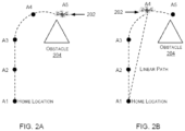
- FIGs. 2A and 2B illustrate exemplary flight paths of an UAV 202 in accordance to an embodiment of the present disclosure.
- FIG. 2A relates to nominal mission that enables UAV 202 to move along a path with a plurality of waypoints, such as waypoints A1, A2, A3, A4, and A5 (more waypoints possible while only these have been shown for better clarity and understanding).
- A1 is "Home Location" from where the UAV 202 starts its nominal mission while moving to other waypoints A2 and onwards.
- the present disclosure provides a method for executing conditional safe-return for an UAV 202 (Unmanned Aerial Vehicle) moving along a path with a plurality of waypoints (herein A1 to A5) for a nominal mission, wherein the method includes the steps of detecting an event of communication failure (near A5) by the UAV 202; self- directing the UAV 202 to a waypoint with last healthy signal (A4) of the plurality of waypoints; and planning, by the UAV 202, an emergency mission with linear flight path from a source to a destination, wherein the source is the waypoint with the last healthy signal and the destination (say home location A1) is pre-configured in the UAV 202.
- the communication failure takes place due to obstruction of line-of-sight from A5 to the UAV 202 by an obstacle 204.
- FIGs. 2A and 2B illustrate conditions for communication failure due to obstacle 204.
- UAV 202 is in a nominal mission mode while origination from A1 (Home Location) but somewhere during the flight, say at waypoint A5, there is obstruction to radio link/signal from the A1 due to presence of obstacle 204 in line-of-sight to the UAV 202/A5.
- A1 Home Location
- A5 Low-power supply
- retracing the nominal path or moving directly from A5 to A1 leads to a security challenge for the UAV 202 from any obstacle(s) in linear path from A5 to A1.
- Retracing the nominal path leads to an undesirably long time lapse with implications to on-board battery life of the UAV 202.
- the USV 202 while flying from Home Location (A1) to further waypoints A2 and thereon, it is possible for the USV 202 to have (while receiving through antenna 112) varying quality, magnitude, or clarity of communication/radio link signal that is required for proper human assisted flight thereof. Such difference in quality of the signal would warrant proper differentiation from considerations such as safety, so as to set a threshold value for a healthy signal while taking into account user preference and other parameters as dynamically read and managed by flight control system 102.
- UAV 202 is configured to move back to waypoint with last healthy signal, in this case waypoint A4.
- the communication failure is due to obstacle 204 obstructing the line-of-sight from A1 to A5
- the UAV 202 (or more particularly flight control system 102) plans a linear flight path (marked with dotted line in FIG. 2B ) from A4 to A1, for which the line-of-sight is expected to be free of any obstacles.
- linear flight path (as illustrated in FIG. 2B ) is not exactly linear from consideration such as change in height of UAV while in-flight for emergency mission. Even otherwise, a constant-height flight could require slight detour(s) from normal straight line of the linear flight path in view of some obstacle(s) and the like that could be readily detected by sensors as elaborated in some aspects of the present disclosure. It could also happen that such detour(s) put the UAV back on path of nominal mission thereafter the UAV reconnects/re-communicates with Home Location, for directions such as rerouting to original pursuit on the nominal mission, or any other command from user.
- selection of waypoint with last healthy signal is done (by UAV) with any or a combination of one or more of the factors selected from the group of battery power status, nominal mission parameters (total time, total distance, distance travelled, payload weight and the like), payload condition/health, on-board sensor status/condition among other factors.
- the UAV is configured to automatically share crucial data pertaining to the waypoint with the LHS as soon as the UAV reconnects with Home Location/user.
- UAV is configured to scan areas in vicinity of path (with a plurality of waypoints) of nominal missions so as to execute a preemptive action in order to prevent or lessen events of communication failure. Such scan would enable the UAV to automatically check for presence of obstacles, by comparing characteristics of objects scanned in the path (or adjoining areas) with pre-stored characteristics/image of obstacles as is accessed through a database.
- the database is mission specific so as to take into account geographical and climatic features among other relevant factors such that there is a higher probability to timely predict and judge presence of obstacle(s).
- the UAV is configured to dynamically update a relevant part of such database as pertains to current and/or upcoming section of the path, keeping in mind constraints of storing large amount of data and various hardware required therefore, among other relevant factors as would be obvious to a person having ordinary knowledge in the art.
- timely detection of obstacles primarily by comparison with database, enables the UAV to automatically maneuver around immediate obstacles or allow timely sharing of such possibilities with user (Home Location) so as to take command from the user.
- UAV is configured with a selection of different maps of target areas whether in a dynamic fashion or pre-stored in its memory.
- online weather updates is provided for the UAV to better equip it for handling of possible communication failures, mainly due to weather and related phenomenon.
- UAV is equipped with an image capturing means such cameras to regularly send images of vicinity of in-flight locations for nominal mission so as to enable a user to proceed accordingly, especially for events such as communication failure where such images is highly beneficial.
- images of areas around the UAV is possibly helping in better judging characteristics/features of obstacle(s) that might have resulted in loss/failure of communication with Home Location.
- images with geo- tags prove to be more beneficial to allow a user to plan SOP, such as from preliminary analysis the situation appears to warrant relocating/moving Home Location/user so as to reconnect for short time period with better line-of-sight.
- the present disclosure provides a shortest-distance flight path for emergency return journey of a UAV while taking into account probability of obstacle(s).
Landscapes
- Engineering & Computer Science (AREA)
- Aviation & Aerospace Engineering (AREA)
- Physics & Mathematics (AREA)
- General Physics & Mathematics (AREA)
- Radar, Positioning & Navigation (AREA)
- Remote Sensing (AREA)
- Automation & Control Theory (AREA)
- Traffic Control Systems (AREA)
- Alarm Systems (AREA)
- Business, Economics & Management (AREA)
- Emergency Management (AREA)
Claims (8)
- Verfahren zum Ausführen einer sicheren Rückkehr eines unbemannten Luftfahrzeugs (UAV) (202), das sich entlang eines Pfades mit einer Vielzahl von Kommunikationswegpunkten bewegt, in einem Fall eines Ausfalls der Kommunikation mit einem Heimatort aufgrund eines Hindernisses in der Sichtlinie zwischen dem UAV und dem Heimatort, wobei das Verfahren die folgenden Schritte umfasst:Erkennen eines Kommunikationsfehlers im UAV (202);Ermöglichen, dass das UAV (202) zum letzten gesunden Kommunikationswegpunkt (A4) zurückkehrt, wobei der Ort des letzten gesunden Kommunikationswegpunkts ein Kommunikationswegpunkt aus der Vielzahl der Kommunikationswegpunkte mit gesundem Signal ist und auf der Grundlage eines oder mehrerer Faktoren ausgewählt wird, die aus der Gruppe des Batteriestatus, des Status/Zustands der Bordsensoren und der nominalen Missionsparameter ausgewählt werden, die die Gesamtzeit, die zurückgelegte Strecke, das Nutzlastgewicht und den Zustand/Gesundheit der Nutzlast umfassen; undRückkehr zum Ausgangsort (A1), wenn die Kommunikation nicht innerhalb einer bestimmten Zeitspanne zurückkehrt.
- Verfahren nach Anspruch 1, wobei das UAV (202) zum Ausgangspunkt (A1) zurückkehrt unter Verwendung des linear kürzesten Flugwegs vom letzten gesunden Kommunikationswegpunkt (A4) zum Ausgangsort (A1).
- Verfahren nach Anspruch 1, wobei das UAV (202) auf einen Benutzerbefehl wartet, falls die Kommunikation innerhalb der definierten Zeitspanne zurückkehrt.
- Ein System, das so konfiguriert ist, dass es die sichere Rückkehr eines UAV (202) ermöglicht, das sich entlang eines Pfades mit einer Vielzahl von Kommunikationswegpunkten bewegt, wenn die Kommunikation mit einem Ausgangsort aufgrund eines Hindernisses in der Sichtlinie zwischen dem UAV und dem Ausgangsort ausfällt, wobei das System umfasst:ein Kommunikationsmodul (110);ein Flugsteuerungssystem (102), das operativ mit dem Kommunikationsmodul (110) gekoppelt ist, um einen Kommunikationsausfall zu erkennen und auf der Grundlage einer solchen Erkennung zum letzten gesunden Kommunikationswegpunkt (A4) zurückzukehren, wobei der letzte gesunde Kommunikationswegpunkt ein Kommunikationswegpunkt aus der Vielzahl von Kommunikationswegpunkten mit gesundem Signal ist und auf der Grundlage eines oder mehrerer Faktoren ausgewählt wird, die aus der Gruppe des Batteriestatus, des Status/Zustands der Bordsensoren und der nominalen Missionsparameter ausgewählt werden, die die Gesamtzeit, die Gesamtstrecke, die zurückgelegte Strecke, das Nutzlastgewicht und den Zustand/Gesundheit der Nutzlast umfassen, wobei das Flugsteuerungssystem (102) so konfiguriert ist, dass es das UAV (202) in die Lage versetzt, zu ihrem Ausgangsort (A1) zurückzukehren, wenn die Kommunikation nicht innerhalb eines definierten Zeitraums zurückkehrt.
- System nach Anspruch 4, wobei das UAV (202) zum Ausgangsort (A1) zurückkehrt, indem es den linear kürzesten Flugweg vom letzten gesunden Kommunikationswegpunkt (A4) zum Ausgangsort (A1) benutzt.
- System nach Anspruch 4, wobei das UAV (202) auf einen Benutzerbefehl wartet, falls die Kommunikation innerhalb der definierten Zeitspanne zurückkehrt.
- System nach Anspruch 4, wobei das Flugsteuerungssystem (102) ferner so konfiguriert ist, dass es unter Verwendung eines oder mehrerer Sensoren Parameter des UAV (202) überwacht, die aus einer beliebigen oder einer Kombination von Standort, Nutzlast, Geschwindigkeit, Höhe, Richtung, zurückgelegtem Weg und Treibstoffstand ausgewählt sind.
- Das System nach Anspruch 4, wobei der Kommunikationsausfall auf der Grundlage des Status der drahtlosen Funkverbindung erkannt wird.
Applications Claiming Priority (2)
| Application Number | Priority Date | Filing Date | Title |
|---|---|---|---|
| IN201721027849 | 2017-08-04 | ||
| PCT/IB2018/055628 WO2019025919A1 (en) | 2017-08-04 | 2018-07-27 | UAV SYSTEM EMERGENCY TRACK PLANNING DURING COMMUNICATION FAILURE |
Publications (3)
| Publication Number | Publication Date |
|---|---|
| EP3662460A1 EP3662460A1 (de) | 2020-06-10 |
| EP3662460A4 EP3662460A4 (de) | 2021-03-31 |
| EP3662460B1 true EP3662460B1 (de) | 2024-12-18 |
Family
ID=65233572
Family Applications (1)
| Application Number | Title | Priority Date | Filing Date |
|---|---|---|---|
| EP18840571.6A Active EP3662460B1 (de) | 2017-08-04 | 2018-07-27 | Uav-system-notwegplanung bei kommunikationsausfall |
Country Status (5)
| Country | Link |
|---|---|
| US (1) | US12008910B2 (de) |
| EP (1) | EP3662460B1 (de) |
| CN (1) | CN110998695A (de) |
| ES (1) | ES3009022T3 (de) |
| WO (1) | WO2019025919A1 (de) |
Families Citing this family (11)
| Publication number | Priority date | Publication date | Assignee | Title |
|---|---|---|---|---|
| US11279481B2 (en) | 2017-05-12 | 2022-03-22 | Phirst Technologies, Llc | Systems and methods for tracking, evaluating and determining a response to emergency situations using unmanned airborne vehicles |
| US11138548B2 (en) * | 2018-11-27 | 2021-10-05 | International Business Machines Corporation | Delivery platform verification and management |
| CN112363491B (zh) * | 2019-07-24 | 2024-04-26 | 杭州萤石软件有限公司 | 机器人掉头控制方法及装置 |
| CN110568860A (zh) * | 2019-09-17 | 2019-12-13 | 深圳市道通智能航空技术有限公司 | 一种无人飞行器的返航方法、装置及无人飞行器 |
| WO2021171056A1 (en) * | 2020-02-24 | 2021-09-02 | Telefonaktiebolaget Lm Ericsson (Publ) | Adaptive virtual dead man's switch for safe operation of autonomous systems |
| US20230072633A1 (en) * | 2021-09-06 | 2023-03-09 | Honeywell International Inc. | Methods and systems for managing user-configured custom routes |
| EP4160148A1 (de) * | 2021-09-30 | 2023-04-05 | Nokia Technologies Oy | Fehlersichere verhaltenskonfiguration für autonome navigation |
| US20230129329A1 (en) * | 2021-10-25 | 2023-04-27 | Aurora Flight Sciences Coporation, A Subsidiary Of The Boing Company | Guidance modes for an unmanned aerial vehicle |
| CN116700274A (zh) * | 2023-06-28 | 2023-09-05 | 珠海云洲智能科技股份有限公司 | 无人艇的航行控制方法、装置、电子设备及存储介质 |
| CN118170155B (zh) * | 2024-05-14 | 2024-09-06 | 中国空气动力研究与发展中心计算空气动力研究所 | 基于深度神经网络的高速滑翔式飞行器在线轨迹优化方法 |
| CN120993953B (zh) * | 2025-10-21 | 2026-02-06 | 天津天境飞航科技有限公司 | 一种复合翼无人机的应急操控方法和系统 |
Family Cites Families (23)
| Publication number | Priority date | Publication date | Assignee | Title |
|---|---|---|---|---|
| SE0300871D0 (sv) * | 2003-03-27 | 2003-03-27 | Saab Ab | Waypoint navigation |
| US7512462B2 (en) * | 2004-11-16 | 2009-03-31 | Northrop Grumman Corporation | Automatic contingency generator |
| US7228232B2 (en) * | 2005-01-24 | 2007-06-05 | International Business Machines Corporation | Navigating a UAV with obstacle avoidance algorithms |
| US9654200B2 (en) * | 2005-07-18 | 2017-05-16 | Mutualink, Inc. | System and method for dynamic wireless aerial mesh network |
| US20110273451A1 (en) * | 2010-05-10 | 2011-11-10 | Salemann Leo J | Computer simulation of visual images using 2d spherical images extracted from 3d data |
| US8787944B2 (en) * | 2011-08-18 | 2014-07-22 | Rivada Research, Llc | Method and system for providing enhanced location based information for wireless handsets |
| WO2013074843A1 (en) * | 2011-11-15 | 2013-05-23 | Insitu, Inc. | Controlled range and payload for unmanned vehicles, and associated systems and methods |
| US8798922B2 (en) * | 2012-11-16 | 2014-08-05 | The Boeing Company | Determination of flight path for unmanned aircraft in event of in-flight contingency |
| US9557742B2 (en) | 2013-11-27 | 2017-01-31 | Aurora Flight Sciences Corporation | Autonomous cargo delivery system |
| EP3100127B8 (de) | 2014-01-31 | 2023-01-04 | Tata Consultancy Services Limited | Computerimplementiertes system und verfahren zur bereitstellung robuster kommunikationsverbindungen mit unbemannten luftfahrzeugen |
| EP3428766B1 (de) * | 2014-09-05 | 2021-04-07 | SZ DJI Technology Co., Ltd. | Abbildung von multisensorumgebungen |
| EP3399381A1 (de) * | 2014-09-05 | 2018-11-07 | SZ DJI Technology Co., Ltd. | Kontextbasierte flugmodusauswahl |
| WO2016210432A1 (en) * | 2015-06-26 | 2016-12-29 | Apollo Robotic Systems Incorporated | Robotic apparatus, systems, and related methods |
| US20170233071A1 (en) * | 2016-02-15 | 2017-08-17 | Skyyfish, LLC | System and Method for Return-Home Command in Manual Flight Control |
| US10043398B2 (en) * | 2016-03-25 | 2018-08-07 | International Business Machines Corporation | Drone coordination |
| US9658619B1 (en) * | 2016-03-31 | 2017-05-23 | Unmanned Innovation, Inc. | Unmanned aerial vehicle modular command priority determination and filtering system |
| US20170351254A1 (en) * | 2016-06-07 | 2017-12-07 | Hunter Arey LISTWIN | Unmanned aerial vehicle control system |
| FR3058609A1 (fr) * | 2016-11-08 | 2018-05-11 | Orange | Synchronisation asynchrone avec un reseau de communication mobile |
| WO2018090209A1 (zh) * | 2016-11-15 | 2018-05-24 | 深圳市大疆创新科技有限公司 | 用于控制可移动物体的方法、设备以及无人飞行器 |
| US10575312B2 (en) * | 2016-12-01 | 2020-02-25 | Electronics And Telecommunications Research Institute | Method of assigning channel for UAS control and non-payload communication (CNPC) system |
| CN106774402A (zh) * | 2016-12-28 | 2017-05-31 | 湖南省道通科技有限公司 | 对无人机进行定位的方法及装置 |
| WO2018133064A1 (zh) * | 2017-01-22 | 2018-07-26 | 深圳市大疆创新科技有限公司 | 可移动装置的控制方法、控制系统、和可移动装置 |
| WO2018156284A1 (en) * | 2017-02-21 | 2018-08-30 | Walmart Apollo, Llc | Systems and methods for delivering merchandise using unmanned aerial vehicles |
-
2018
- 2018-07-27 ES ES18840571T patent/ES3009022T3/es active Active
- 2018-07-27 CN CN201880050797.2A patent/CN110998695A/zh active Pending
- 2018-07-27 WO PCT/IB2018/055628 patent/WO2019025919A1/en not_active Ceased
- 2018-07-27 US US16/636,412 patent/US12008910B2/en active Active
- 2018-07-27 EP EP18840571.6A patent/EP3662460B1/de active Active
Non-Patent Citations (1)
| Title |
|---|
| ANONYMOUS: "eBee senseFly Extended User Manual", 30 April 2015 (2015-04-30), XP055304129, Retrieved from the Internet <URL:https://www.sensefly.com/fileadmin/user_upload/sensefly/documents/manuals/Extended_User_Manual_eBee_and_eBee_Ag_v16.pdf> [retrieved on 20160920] * |
Also Published As
| Publication number | Publication date |
|---|---|
| US20200175882A1 (en) | 2020-06-04 |
| EP3662460A1 (de) | 2020-06-10 |
| WO2019025919A1 (en) | 2019-02-07 |
| US12008910B2 (en) | 2024-06-11 |
| ES3009022T3 (en) | 2025-03-25 |
| EP3662460A4 (de) | 2021-03-31 |
| CN110998695A (zh) | 2020-04-10 |
Similar Documents
| Publication | Publication Date | Title |
|---|---|---|
| US12008910B2 (en) | UAV system emergency path planning on communication failure | |
| US10824170B2 (en) | Autonomous cargo delivery system | |
| RU2733453C1 (ru) | Способ автоматического управления движением роботизированного беспилотного летательного аппарата в автономном режиме | |
| JP6785874B2 (ja) | 無人航空機用視野ベース較正システム | |
| EP4009128B1 (de) | Flugbahnbestimmung | |
| US10133281B1 (en) | Leading drone system | |
| EP3619584B1 (de) | Unterwasserführungsdrohnensystem | |
| JP2021509096A (ja) | 自律型無人航空機及びその制御方法 | |
| US20180231972A1 (en) | System for performing tasks in an operating region and method of controlling autonomous agents for performing tasks in the operating region | |
| US20180321681A1 (en) | Leading drone method | |
| US12590816B2 (en) | Route planning for a ground vehicle through unfamiliar terrain | |
| Nonami | Present state and future prospect of autonomous control technology for industrial drones | |
| CN120161761B (zh) | 无人机集群协同飞行控制系统及方法 | |
| US12165532B1 (en) | Autonomous control techniques for avoiding collisions with cooperative aircraft | |
| WO2024054310A2 (en) | Multi-drone systems and methods to improve inertial navigation | |
| Gryte et al. | Control system architecture for automatic recovery of fixed-wing unmanned aerial vehicles in a moving arrest system | |
| KR102243823B1 (ko) | 관제 서버 및 그를 이용한 무인 비행체의 비행경로 설정방법 | |
| Poza-Luján et al. | Indoor drones for the creative industries: Distinctive features/opportunities in safety navigation | |
| US10558209B1 (en) | System and method for cooperative operation of piloted and optionally piloted aircraft | |
| WO2024205621A1 (en) | Intelligent flight management system for multiple uavs in base station networks | |
| KR20200098000A (ko) | 관제 서버 및 그를 이용한 무인 비행체의 비행경로 설정방법 | |
| JP2020057311A (ja) | 移動計画算出装置及びプログラム | |
| KR102070110B1 (ko) | 자율 무인 시스템을 위한 지능 에이전트 시스템 | |
| Hartman et al. | Development of a Velocity Controller for Following a Human Using Target Velocity in a GPS-Denied Environment | |
| Hussein et al. | Building blocks and interaction patterns of unmanned aerial systems |
Legal Events
| Date | Code | Title | Description |
|---|---|---|---|
| STAA | Information on the status of an ep patent application or granted ep patent |
Free format text: STATUS: THE INTERNATIONAL PUBLICATION HAS BEEN MADE |
|
| PUAI | Public reference made under article 153(3) epc to a published international application that has entered the european phase |
Free format text: ORIGINAL CODE: 0009012 |
|
| STAA | Information on the status of an ep patent application or granted ep patent |
Free format text: STATUS: REQUEST FOR EXAMINATION WAS MADE |
|
| 17P | Request for examination filed |
Effective date: 20200213 |
|
| AK | Designated contracting states |
Kind code of ref document: A1 Designated state(s): AL AT BE BG CH CY CZ DE DK EE ES FI FR GB GR HR HU IE IS IT LI LT LU LV MC MK MT NL NO PL PT RO RS SE SI SK SM TR |
|
| AX | Request for extension of the european patent |
Extension state: BA ME |
|
| DAV | Request for validation of the european patent (deleted) | ||
| DAX | Request for extension of the european patent (deleted) | ||
| A4 | Supplementary search report drawn up and despatched |
Effective date: 20210303 |
|
| RIC1 | Information provided on ipc code assigned before grant |
Ipc: G08G 5/04 20060101AFI20210225BHEP |
|
| STAA | Information on the status of an ep patent application or granted ep patent |
Free format text: STATUS: EXAMINATION IS IN PROGRESS |
|
| 17Q | First examination report despatched |
Effective date: 20220208 |
|
| GRAP | Despatch of communication of intention to grant a patent |
Free format text: ORIGINAL CODE: EPIDOSNIGR1 |
|
| STAA | Information on the status of an ep patent application or granted ep patent |
Free format text: STATUS: GRANT OF PATENT IS INTENDED |
|
| INTG | Intention to grant announced |
Effective date: 20240819 |
|
| GRAS | Grant fee paid |
Free format text: ORIGINAL CODE: EPIDOSNIGR3 |
|
| GRAA | (expected) grant |
Free format text: ORIGINAL CODE: 0009210 |
|
| STAA | Information on the status of an ep patent application or granted ep patent |
Free format text: STATUS: THE PATENT HAS BEEN GRANTED |
|
| AK | Designated contracting states |
Kind code of ref document: B1 Designated state(s): AL AT BE BG CH CY CZ DE DK EE ES FI FR GB GR HR HU IE IS IT LI LT LU LV MC MK MT NL NO PL PT RO RS SE SI SK SM TR |
|
| REG | Reference to a national code |
Ref country code: GB Ref legal event code: FG4D |
|
| REG | Reference to a national code |
Ref country code: CH Ref legal event code: EP |
|
| REG | Reference to a national code |
Ref country code: DE Ref legal event code: R096 Ref document number: 602018077787 Country of ref document: DE |
|
| REG | Reference to a national code |
Ref country code: IE Ref legal event code: FG4D |
|
| REG | Reference to a national code |
Ref country code: ES Ref legal event code: FG2A Ref document number: 3009022 Country of ref document: ES Kind code of ref document: T3 Effective date: 20250325 |
|
| REG | Reference to a national code |
Ref country code: LT Ref legal event code: MG9D |
|
| PG25 | Lapsed in a contracting state [announced via postgrant information from national office to epo] |
Ref country code: HR Free format text: LAPSE BECAUSE OF FAILURE TO SUBMIT A TRANSLATION OF THE DESCRIPTION OR TO PAY THE FEE WITHIN THE PRESCRIBED TIME-LIMIT Effective date: 20241218 |
|
| PG25 | Lapsed in a contracting state [announced via postgrant information from national office to epo] |
Ref country code: FI Free format text: LAPSE BECAUSE OF FAILURE TO SUBMIT A TRANSLATION OF THE DESCRIPTION OR TO PAY THE FEE WITHIN THE PRESCRIBED TIME-LIMIT Effective date: 20241218 |
|
| PG25 | Lapsed in a contracting state [announced via postgrant information from national office to epo] |
Ref country code: BG Free format text: LAPSE BECAUSE OF FAILURE TO SUBMIT A TRANSLATION OF THE DESCRIPTION OR TO PAY THE FEE WITHIN THE PRESCRIBED TIME-LIMIT Effective date: 20241218 |
|
| PG25 | Lapsed in a contracting state [announced via postgrant information from national office to epo] |
Ref country code: NO Free format text: LAPSE BECAUSE OF FAILURE TO SUBMIT A TRANSLATION OF THE DESCRIPTION OR TO PAY THE FEE WITHIN THE PRESCRIBED TIME-LIMIT Effective date: 20250318 |
|
| REG | Reference to a national code |
Ref country code: NL Ref legal event code: MP Effective date: 20241218 |
|
| PG25 | Lapsed in a contracting state [announced via postgrant information from national office to epo] |
Ref country code: LV Free format text: LAPSE BECAUSE OF FAILURE TO SUBMIT A TRANSLATION OF THE DESCRIPTION OR TO PAY THE FEE WITHIN THE PRESCRIBED TIME-LIMIT Effective date: 20241218 Ref country code: GR Free format text: LAPSE BECAUSE OF FAILURE TO SUBMIT A TRANSLATION OF THE DESCRIPTION OR TO PAY THE FEE WITHIN THE PRESCRIBED TIME-LIMIT Effective date: 20250319 |
|
| PG25 | Lapsed in a contracting state [announced via postgrant information from national office to epo] |
Ref country code: RS Free format text: LAPSE BECAUSE OF FAILURE TO SUBMIT A TRANSLATION OF THE DESCRIPTION OR TO PAY THE FEE WITHIN THE PRESCRIBED TIME-LIMIT Effective date: 20250318 |
|
| PG25 | Lapsed in a contracting state [announced via postgrant information from national office to epo] |
Ref country code: NL Free format text: LAPSE BECAUSE OF FAILURE TO SUBMIT A TRANSLATION OF THE DESCRIPTION OR TO PAY THE FEE WITHIN THE PRESCRIBED TIME-LIMIT Effective date: 20241218 |
|
| REG | Reference to a national code |
Ref country code: AT Ref legal event code: MK05 Ref document number: 1752895 Country of ref document: AT Kind code of ref document: T Effective date: 20241218 |
|
| PG25 | Lapsed in a contracting state [announced via postgrant information from national office to epo] |
Ref country code: SM Free format text: LAPSE BECAUSE OF FAILURE TO SUBMIT A TRANSLATION OF THE DESCRIPTION OR TO PAY THE FEE WITHIN THE PRESCRIBED TIME-LIMIT Effective date: 20241218 |
|
| PG25 | Lapsed in a contracting state [announced via postgrant information from national office to epo] |
Ref country code: PL Free format text: LAPSE BECAUSE OF FAILURE TO SUBMIT A TRANSLATION OF THE DESCRIPTION OR TO PAY THE FEE WITHIN THE PRESCRIBED TIME-LIMIT Effective date: 20241218 |
|
| PGFP | Annual fee paid to national office [announced via postgrant information from national office to epo] |
Ref country code: GB Payment date: 20250520 Year of fee payment: 8 |
|
| PG25 | Lapsed in a contracting state [announced via postgrant information from national office to epo] |
Ref country code: IS Free format text: LAPSE BECAUSE OF FAILURE TO SUBMIT A TRANSLATION OF THE DESCRIPTION OR TO PAY THE FEE WITHIN THE PRESCRIBED TIME-LIMIT Effective date: 20250418 |
|
| PGFP | Annual fee paid to national office [announced via postgrant information from national office to epo] |
Ref country code: IT Payment date: 20250520 Year of fee payment: 8 |
|
| PG25 | Lapsed in a contracting state [announced via postgrant information from national office to epo] |
Ref country code: PT Free format text: LAPSE BECAUSE OF FAILURE TO SUBMIT A TRANSLATION OF THE DESCRIPTION OR TO PAY THE FEE WITHIN THE PRESCRIBED TIME-LIMIT Effective date: 20250421 |
|
| PG25 | Lapsed in a contracting state [announced via postgrant information from national office to epo] |
Ref country code: EE Free format text: LAPSE BECAUSE OF FAILURE TO SUBMIT A TRANSLATION OF THE DESCRIPTION OR TO PAY THE FEE WITHIN THE PRESCRIBED TIME-LIMIT Effective date: 20241218 |
|
| PGFP | Annual fee paid to national office [announced via postgrant information from national office to epo] |
Ref country code: FR Payment date: 20250520 Year of fee payment: 8 |
|
| PG25 | Lapsed in a contracting state [announced via postgrant information from national office to epo] |
Ref country code: RO Free format text: LAPSE BECAUSE OF FAILURE TO SUBMIT A TRANSLATION OF THE DESCRIPTION OR TO PAY THE FEE WITHIN THE PRESCRIBED TIME-LIMIT Effective date: 20241218 Ref country code: AT Free format text: LAPSE BECAUSE OF FAILURE TO SUBMIT A TRANSLATION OF THE DESCRIPTION OR TO PAY THE FEE WITHIN THE PRESCRIBED TIME-LIMIT Effective date: 20241218 |
|
| PG25 | Lapsed in a contracting state [announced via postgrant information from national office to epo] |
Ref country code: SK Free format text: LAPSE BECAUSE OF FAILURE TO SUBMIT A TRANSLATION OF THE DESCRIPTION OR TO PAY THE FEE WITHIN THE PRESCRIBED TIME-LIMIT Effective date: 20241218 |
|
| PG25 | Lapsed in a contracting state [announced via postgrant information from national office to epo] |
Ref country code: CZ Free format text: LAPSE BECAUSE OF FAILURE TO SUBMIT A TRANSLATION OF THE DESCRIPTION OR TO PAY THE FEE WITHIN THE PRESCRIBED TIME-LIMIT Effective date: 20241218 |
|
| PG25 | Lapsed in a contracting state [announced via postgrant information from national office to epo] |
Ref country code: SE Free format text: LAPSE BECAUSE OF FAILURE TO SUBMIT A TRANSLATION OF THE DESCRIPTION OR TO PAY THE FEE WITHIN THE PRESCRIBED TIME-LIMIT Effective date: 20241218 |
|
| REG | Reference to a national code |
Ref country code: DE Ref legal event code: R097 Ref document number: 602018077787 Country of ref document: DE |
|
| PGFP | Annual fee paid to national office [announced via postgrant information from national office to epo] |
Ref country code: ES Payment date: 20250805 Year of fee payment: 8 |
|
| PG25 | Lapsed in a contracting state [announced via postgrant information from national office to epo] |
Ref country code: DK Free format text: LAPSE BECAUSE OF FAILURE TO SUBMIT A TRANSLATION OF THE DESCRIPTION OR TO PAY THE FEE WITHIN THE PRESCRIBED TIME-LIMIT Effective date: 20241218 |
|
| PGFP | Annual fee paid to national office [announced via postgrant information from national office to epo] |
Ref country code: DE Payment date: 20250520 Year of fee payment: 8 |
|
| PLBE | No opposition filed within time limit |
Free format text: ORIGINAL CODE: 0009261 |
|
| STAA | Information on the status of an ep patent application or granted ep patent |
Free format text: STATUS: NO OPPOSITION FILED WITHIN TIME LIMIT |
|
| REG | Reference to a national code |
Ref country code: CH Ref legal event code: L10 Free format text: ST27 STATUS EVENT CODE: U-0-0-L10-L00 (AS PROVIDED BY THE NATIONAL OFFICE) Effective date: 20251029 |
|
| 26N | No opposition filed |
Effective date: 20250919 |
|
| REG | Reference to a national code |
Ref country code: CH Ref legal event code: H13 Free format text: ST27 STATUS EVENT CODE: U-0-0-H10-H13 (AS PROVIDED BY THE NATIONAL OFFICE) Effective date: 20260224 |
|
| PG25 | Lapsed in a contracting state [announced via postgrant information from national office to epo] |
Ref country code: LU Free format text: LAPSE BECAUSE OF NON-PAYMENT OF DUE FEES Effective date: 20250727 |
|
| REG | Reference to a national code |
Ref country code: BE Ref legal event code: MM Effective date: 20250731 |
|
| PG25 | Lapsed in a contracting state [announced via postgrant information from national office to epo] |
Ref country code: BE Free format text: LAPSE BECAUSE OF NON-PAYMENT OF DUE FEES Effective date: 20250731 |
|
| PG25 | Lapsed in a contracting state [announced via postgrant information from national office to epo] |
Ref country code: CH Free format text: LAPSE BECAUSE OF NON-PAYMENT OF DUE FEES Effective date: 20250731 |