EP3648046A1 - Agricultural support system, agricultural support device and agricultural support method - Google Patents
Agricultural support system, agricultural support device and agricultural support method Download PDFInfo
- Publication number
- EP3648046A1 EP3648046A1 EP18825127.6A EP18825127A EP3648046A1 EP 3648046 A1 EP3648046 A1 EP 3648046A1 EP 18825127 A EP18825127 A EP 18825127A EP 3648046 A1 EP3648046 A1 EP 3648046A1
- Authority
- EP
- European Patent Office
- Prior art keywords
- data
- spreading
- areas
- spreading amount
- map
- Prior art date
- Legal status (The legal status is an assumption and is not a legal conclusion. Google has not performed a legal analysis and makes no representation as to the accuracy of the status listed.)
- Withdrawn
Links
Images








Classifications
-
- A—HUMAN NECESSITIES
- A01—AGRICULTURE; FORESTRY; ANIMAL HUSBANDRY; HUNTING; TRAPPING; FISHING
- A01B—SOIL WORKING IN AGRICULTURE OR FORESTRY; PARTS, DETAILS, OR ACCESSORIES OF AGRICULTURAL MACHINES OR IMPLEMENTS, IN GENERAL
- A01B79/00—Methods for working soil
- A01B79/005—Precision agriculture
-
- A—HUMAN NECESSITIES
- A01—AGRICULTURE; FORESTRY; ANIMAL HUSBANDRY; HUNTING; TRAPPING; FISHING
- A01C—PLANTING; SOWING; FERTILISING
- A01C21/00—Methods of fertilising, sowing or planting
- A01C21/007—Determining fertilization requirements
-
- G—PHYSICS
- G01—MEASURING; TESTING
- G01C—MEASURING DISTANCES, LEVELS OR BEARINGS; SURVEYING; NAVIGATION; GYROSCOPIC INSTRUMENTS; PHOTOGRAMMETRY OR VIDEOGRAMMETRY
- G01C21/00—Navigation; Navigational instruments not provided for in groups G01C1/00 - G01C19/00
- G01C21/005—Navigation; Navigational instruments not provided for in groups G01C1/00 - G01C19/00 with correlation of navigation data from several sources, e.g. map or contour matching
-
- G—PHYSICS
- G06—COMPUTING OR CALCULATING; COUNTING
- G06Q—INFORMATION AND COMMUNICATION TECHNOLOGY [ICT] SPECIALLY ADAPTED FOR ADMINISTRATIVE, COMMERCIAL, FINANCIAL, MANAGERIAL OR SUPERVISORY PURPOSES; SYSTEMS OR METHODS SPECIALLY ADAPTED FOR ADMINISTRATIVE, COMMERCIAL, FINANCIAL, MANAGERIAL OR SUPERVISORY PURPOSES, NOT OTHERWISE PROVIDED FOR
- G06Q50/00—Information and communication technology [ICT] specially adapted for implementation of business processes of specific business sectors, e.g. utilities or tourism
- G06Q50/02—Agriculture; Fishing; Forestry; Mining
-
- A—HUMAN NECESSITIES
- A01—AGRICULTURE; FORESTRY; ANIMAL HUSBANDRY; HUNTING; TRAPPING; FISHING
- A01M—CATCHING, TRAPPING OR SCARING OF ANIMALS; APPARATUS FOR THE DESTRUCTION OF NOXIOUS ANIMALS OR NOXIOUS PLANTS
- A01M9/00—Special adaptations or arrangements of powder-spraying apparatus for purposes covered by this subclass
- A01M9/0092—Regulating or controlling systems
-
- Y—GENERAL TAGGING OF NEW TECHNOLOGICAL DEVELOPMENTS; GENERAL TAGGING OF CROSS-SECTIONAL TECHNOLOGIES SPANNING OVER SEVERAL SECTIONS OF THE IPC; TECHNICAL SUBJECTS COVERED BY FORMER USPC CROSS-REFERENCE ART COLLECTIONS [XRACs] AND DIGESTS
- Y02—TECHNOLOGIES OR APPLICATIONS FOR MITIGATION OR ADAPTATION AGAINST CLIMATE CHANGE
- Y02A—TECHNOLOGIES FOR ADAPTATION TO CLIMATE CHANGE
- Y02A40/00—Adaptation technologies in agriculture, forestry, livestock or agroalimentary production
- Y02A40/10—Adaptation technologies in agriculture, forestry, livestock or agroalimentary production in agriculture
- Y02A40/22—Improving land use; Improving water use or availability; Controlling erosion
Definitions
- the present invention relates to an agriculture support system, to an agriculture support system, and to an agriculture support method.
- Patent document 1 A technique for setting a fertilizing amount to an agricultural field disclosed Patent document 1 is previously known.
- the fertilization amount setting method disclosed in Patent Document 1 includes a yield difference calculation step for calculating a yield difference that is a difference between a target yield of the grain and an actual result value of the yield of the grain, and a taste difference calculation step for calculating a taste difference that is a difference between a target taste value of the grain and an actual result value of the taste value.
- the method sets the fertilization amount by inputting, to a mobile terminal or the like, a weighting value for the yield difference calculated at the yield difference calculation step and for the taste difference calculated at the taste difference calculation step.
- Patent Document 1 Japanese Unexamined Patent Application Publication No. 2013-234935
- the fertilization amount setting method of Patent Document 1 the fertilization amount is calculated by inputting a weight value to the mobile terminal, paying attention to the fact that the yield and the taste are in the trade-off relation.
- the fertilization amount setting method of Patent Document 1 is a useful technique because the fertilization amount can be set appropriately, the fertilization amount cannot be set while grasping variations of the yield in the entire field.
- the present invention intends to provide an agriculture support system, an agriculture support device, and an agriculture support method capable of easily setting a spreading amount of the spread substance.
- An agriculture support system includes: a data obtaining device to obtain at least one type of data among a plurality of types of data relating to planting of crops; a mesh setting device to allocate, as divided data, the data obtained by the data obtaining device to each of areas of an agricultural field in which the crops are planted; a first map display to relate, to a location of the agricultural field, the divided data allocated to each of the areas by the mesh setting device and to display the divided data as a first field map; a spreading setting device to set a spreading amount of spread substance in each of the areas based on the divided data of each of the areas; and a second map display to relate, to the location of the agricultural field, the spreading amount set to each of the areas by the spreading setting device and to display the spreading amount as a second field map.
- the agriculture support system includes a grouping device to group the divided data of each of the areas, the divided data being allocated by the mesh setting device.
- the spreading setting device sets the spreading amount in each of the area based on the groups determined in each of the areas by the grouping device.
- the spreading setting device sets the spreading amount in each of the areas based on a set spreading amount determined to each of the groups.
- the agriculture support system includes an input device to input the set spreading amount for each of the groups.
- the agriculture support system includes a criterion changer device to change a criterion value used for grouping the divided data of each of the areas.
- the mesh setting device interpolates the divided data.
- the agriculture support system includes a spreading amount changer device to change the spreading amount for each of the areas. the spreading amount being set by the spreading setting device.
- the agriculture support system includes a spreading machine to spread the spread substance; and a spreading transmitter device to transmit the spreading amount in each of the areas to the spreading machine configured to spread the spread substance.
- the agriculture support system includes an auto determining device to automatically determine the set spreading amount that is inputted to the input device.
- the plurality of types of data include any of yields of the crops, taste of the crops, growing state of the crops, and components of soil.
- An agriculture support device includes: a data obtaining device to obtain at least one type of data among a plurality of types of data relating to planting of crops; a mesh setting device to allocate, as divided data, the data obtained by the data obtaining device to each of areas of an agricultural field in which the crops are planted; a first map display to relate, to a location of the agricultural field, the divided data allocated to each of the areas by the mesh setting device and to display the divided data as a first field map; a spreading setting device to set a spreading amount of spread substance in each of the areas based on the divided data of each of the areas; and a second map display to relate, to the location of the agricultural field, the spreading amount set to each of the areas by the spreading setting device and to display the spreading amount as a second field map.
- An agriculture support method includes: a data obtaining step for obtaining at least one type of data among a plurality of types of data relating to planting of crops; a mesh setting step for allocating, as divided data, the data obtained at the data obtaining step to each of areas of an agricultural field in which the crops are planted; a first displaying step for relating, to a location of the agricultural field, the divided data allocated to each of the areas at the mesh setting step and displaying the divided data as a first field map; a spreading setting step to set a spreading amount of spread substance in each of the areas based on the divided data of each of the areas; and a second displaying step for relating, to the location of the agricultural field, the spreading amount set to each of the areas at the spreading setting step and displaying the spreading amount as a second field map.
- An agriculture support system includes: a data obtaining device to obtain at least two types of data among a plurality of types of data relating to planting of crops; a mesh setting device to allocate, as divided data, the at least two types of data obtained by the data obtaining device to each of areas of an agricultural field in which the crops are planted; and a spreading setting device to set a spreading amount of spread substance in each of the areas based on at least two types of the divided data allocated to each of the areas by the mesh setting device.
- the agriculture support system includes a grouping device to group the divided data of identical one of the areas among the at least two types of divided data.
- the spreading setting device sets the spreading amount in each of the area based on the groups determined by the grouping device.
- the agriculture support system includes a data display to display the at least two types of divided data on a distribution map that has at least a plurality of indexes.
- the agriculture support system includes a grouping device to group the divided data of identical one of the areas among the at least two types of divided data.
- the data display displays the distribution map that has a vertical line serving as a first index of the plurality of indexes and has a horizontal line serving as a second index.
- the grouping device performs the grouping a predetermined range displayed on the distribution map.
- the agriculture support system includes a threshold setting device to set an upper limit or a lower limit of the predetermined range.
- the agriculture support system includes a spreading amount changer device to change the spreading amount set to each of the areas by the spreading setting device.
- the agriculture support system includes a map display to relate, to the location of the agricultural field, the spreading amount set to each of the areas by the spreading setting device and to display the spreading amount as a field map.
- the agriculture support system includes a spreading transmitter device to transmit the spreading amount in each of the areas to the spreading machine configured to spread the spread substance.
- the plurality of types of data include any of yields of the crops, taste of the crops, growing state of the crops, and components of soil.
- An agriculture support device includes: a data obtaining device to obtain at least two types of data among a plurality of types of data relating to planting of crops; a mesh setting device to allocate, as divided data, the at least two types of data obtained by the data obtaining device to each of areas of an agricultural field in which the crops are planted; and a spreading setting device to set a spreading amount of spread substance in each of the areas based on at least two types of the divided data allocated to each of the areas by the mesh setting device.
- An agriculture support method includes: a data obtaining step for obtaining at least two types of data among a plurality of types of data relating to planting of crops; a mesh setting step for allocating, as divided data, the at least two types of data obtained at the data obtaining step to each of areas of an agricultural field in which the crops are planted; and a spreading setting step for setting a spreading amount of spread substance in each of the areas based on at least two types of the divided data allocated to each of the areas at the mesh setting step.
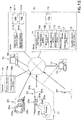
- FIG. 1 shows an agriculture support system.
- the agriculture support system is a system that provides support relating to the spreading of the spread substance, for example.
- the spread substance (the spread agent) is, for example, chemical agents (agrochemicals), fertilizers, or the like.
- the agriculture support system includes a computer.
- the computer includes, for example, a management computer 1a installed in a farmer's house, a farming company, or the like, and includes a server 1b to which the management computer 1 a can be connected.
- the management computer 1a is, for example, a personal computer (PC) assigned to an administrator or an operator.
- the management computer 1a may be a mobile terminal such as a smartphone, a tablet, or a PDA.
- the server 1b is an agriculture support device that supports the agriculture operation, and is configured to obtain various types of data (information) related to the agriculture.
- the server 1b obtains data related to the cropping, for example, the data such as the crops data and the soil data.
- the crops data and the soil data are data obtained through the remote sensing method, for example.
- the crops data is data related to the crops planted in the agricultural field, for example, the data indicating the yield of the crops in the agricultural field (the yield data), the data indicating the chemical composition of the crops (the crops components data), and the data indicating the growth status of the crops (the growth data).
- the crops components data is, for example, the water content rate of the crops (the moisture content), the taste of the crops (the protein content), and the like.
- the soil data is data related to the soil in the agricultural field, for example, the data indicating the chemical compositions of the soil (the soil components data).
- the yield data and the crops components data are detected by, for example, the harvester (harvesting machine) 20 in harvesting the crops.
- the harvesting machine 20 is a combine configured to harvest the crops.
- the harvesting machine 20 includes a measurement device 20a, a communication device 20b, and a position detector device 20c.
- the measurement device 20a includes a load cell configured to detect the weight (the yield) of the harvested crops, and includes a spectroscopic analysis device configured to measure the moisture content and the protein content of the harvested crops.
- the position detector device 20c is a device configured to detect the position of the harvesting machine 20, that is, the position detector device 20 detects a position (the latitude, the longitude) based on data from the positioning satellites such as the GPS.
- the harvesting machine 20 obtains the yield data by associating the position detected by the position detector device 20c with the weight (the yield) of the crops detected by the measuring device 20a when the crops is harvested.
- the harvesting machine 20 obtains the crops components data by associating the position detected by the position detector device 20c with the moisture content (the water content rate) and the protein content (the protein content rate) of the crops detected by the measuring device 20a when the crops is harvested.
- the communication device 20b is a device configured to transmit detected information that is detected at least by the harvesting machine 20, that is, to transmit the yield data and the crops components data (the moisture content rate, the protein content rate) to the outside.
- the communication device 20b transmits the yield data and the crops components data (the moisture content rate, the protein content rate) to the server 1b.
- the server 1b Upon receiving the yield data and the crops components data (the moisture content rate, the protein content rate), the server 1b stores, in the storage portion (the database) 10, the yield data received and the crops components data (the moisture content rate, the protein content rate) received.
- the original data of the growth data is detected by an unmanned flying object 30 such as a multicopter.
- the multicopter 30 includes a main body 30a, an arm 30b provided on the main body 30a, a rotary blade 30c provided on the arm 30b, and a skid 30d provided on the main body 30a.
- the rotary blade 30c is a device that generates a lifting force for the flying, and includes a rotor that provides a rotational force, and includes a blade (a propeller) that is rotated by the rotational force of the rotor.
- the multicopter 30 includes an imaging device 30e.
- the imaging device 30e is a device constituted of an infrared camera or the like, and is capable of imaging crops in an agricultural field.
- the multicopter 30 has the position detector device 30f.
- the position detector device 30f is a device configured to detect the position of the multicopter 30, and detects a position (the latitude and the longitude) based on data from the positioning satellite such as the GPS.
- the multicopter 30 flies over the agricultural field and takes aerial images of the crops on the agricultural field, and then obtains the captured image data by associating the image (the captured image) captured by the imaging device 30e with the position detected by the position detecting device 30f.
- the image data is stored in the storage portion 30g provided in the multicopter 30.
- the image data stored in the storage portion 30g of the multicopter 30 is transferred to an electronic storage medium 31 such as a USB memory or an SD card, and then is stored in the electronic storage medium 31.
- the image data stored in the electronic storage medium 31 is transferred to the management computer 1a or a fixed management computer 1c installed in an aerial photography service company or the like separately from the management computer 1a.
- the imaging data transferred is stored in the management computer 1 a or the management computer 1 c.
- the image data stored in the management computer 1a or the management computer 1c is transmitted to the server 1b.
- the server 1b When receiving the image data, the server 1b stores the received imaging data in the storage portion (the database) 10. The server 1b analyzes the captured data (the captured image) to generate the growth data based on the vegetation indexes such as the DVI, the RVI, the NDVI, the GNDVI, the SAVI, the TSAVI, the CAI, the MTCI, the REP, the PRI, and the RSI.
- the growth data generated by the server 1b is stored in the storage portion 10.
- the vegetation indexes mentioned above is just an example and is not limited thereto.
- the growth data may be generated from the image data by the management computer 1a or the management computer 1c, and the generated growth data may be transmitted from the management computer 1a or the management computer 1c to the server 1b.
- the crops in the agricultural field are imaged by the multicopter 30, but as shown in FIG. 1 , the crops in the agricultural field may be imaged by the agricultural field monitoring device 32 installed in the agricultural field, and the image data may be obtained by adding, to the captured image the position of the agricultural field related to the agricultural field monitoring device 32.
- the soil data can be obtained by capturing an image of the agricultural field with an imaging device such as a camera and further by analyzing the captured image. That is, the "growth data" described above may be replaced with the "soil data”.
- the server 1b is configured to obtain, as the crops data, the yield data, the crops components data (the moisture content rate, the protein content rate), and the growth data, and configured to store, as a database, the data in the storage portion 10.
- the server 1b is configured to obtain the soil data, and configured to save, as a database, he data in the storage portion 10.
- the crops data [the yield data, the crops components data (the moisture content rate, the protein content rate), the growth data] and the soil data include the position information such as a position (the latitude, the longitude).
- the server 1b is configured to create a spreading plan for the spreading on the agricultural field with reference to the above-mentioned crops data, the above-mentioned soil data, and the like.
- the spreading plan is a plan for setting how much the spread substance (fertilizer, chemicals, or the like) is spread on which part of the agricultural field at least in a predetermined agricultural field.
- the server 1b includes a first spreading planning portion 11.
- the first spreading planning portion 11 is constituted of the electric/electronic components provided in the server 1b, the electric circuit, the computer program stored in the server 1b, or the like.
- the first spreading planning portion 11 creates a spreading plan for spreading on the agricultural field with use of at least one piece of data (one type of data) among the crops data (the yield data, the crops components data, the growth data, and the soil data).
- a menu screen for selecting a menu or the like is displayed on the display portion 40 of the management computer 1a.
- the display portion 40 is constituted of a liquid crystal monitor or the like.
- the management computer 1a When an icon, a button, or the like of the spreading plan is selected on the menu screen and a predetermined operation is performed, the management computer 1a requests the server 1b to create the spreading plan.
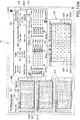
- the first spreading planning portion 11 of the server 1b displays, on the management computer 1a, a setting screen T1 for making a spreading plan as shown in FIG. 2 .
- the setting screen T1 includes a first map display portion 51, a second map display portion 52, a basic display portion 53, and a spread designing portion 54.
- the first map display portion 51 displays a map obtained from data to be referred to in creating the spreading plan.
- the first map display portion 51 respectively displays a first agricultural field map [the yield map, the crops components map (the moisture map, the taste map, and the like), the growth map, and the soil map] M1 on the basis of each of the yield data, the crops components data (the moisture content rate, the protein content rate), the growth data, and the soil data.
- the first agricultural field map M1 selected on the first map display portion 51 is referred to as a "selected agricultural field map".
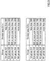
- the divided data D1n is divided into groups of five levels according to the numerical values.
- the group with the smallest numerical value is a "first group G1”
- the group with the largest numerical value is a "fifth group G5".
- the "second group G2,” the “third group G3,” and the "fourth group G4" are assigned in the order from the group with the smaller numerical value.
- the numerical values shown in FIG. 3 are numerical values for explaining the grouping, and are not limited thereto.
- the second map display portion 52 displays a second agricultural field map (a spreading amount map) M2 including the spreading amount set based on the first agricultural field map M1 displayed on the first map display portion 51.
- the second agricultural field map M2 is a mesh-type map in which one agricultural field is divided into a plurality of areas Qn, and the length of the mesh width (an area width) and the number of meshes (the number of areas) is set in the same manner as the first agricultural field map M1 corresponding to the first agricultural field map M1.
- the second agricultural field map M2 is a map to which a plurality of groups are assigned in accordance with the size (the value) of the divided data D2n corresponding to the plurality of areas Qn.
- the groups (the ranks) are indicated by colors, numerical values, characters, or the like so that the groups (ranks) assigned in advance can be identified for each of the plurality of areas Qn.
- the numerical values shown in the plurality of areas Qn of the first agricultural field map M1 indicate the groups.
- the divided data D2n is divided into groups of five levels according to the numerical value.
- the group with the smallest numerical value is the "first group G1”
- the group with the largest numerical value is the "fifth group G5.
- the "second group G2,” the “third group G3,” and the "fourth group G4" are assigned in the order from the group with the smaller numerical value. That is, the number of grooves assigned corresponding to the divided data D2n is equal to the number of groups assigned corresponding to the divided data D1n.
- the number of groups into which the divided data D2n is divided is arbitrary, and is not limited to the above-described example.
- the numerical values shown in FIG. 3 are numerical values for explaining the grouping, and are not limited thereto.
- the basic display portion 53 displays the information (the agricultural field information) relating to the agricultural field to which the fertilization plan is set.
- the basic display portion 53 displays the agricultural field name and the agricultural field area registered in advance in the management computer 1a or the server 1b.
- the basic display portion 53 may display the basic information of the selected farm map M1 in the first agricultural field map M1 displayed on the first map display 51. For example, when the selected agricultural field map M1 is the yield map, the date and time when the crops was harvested, the name of the harvester that harvested the crops, the model number, and the like are displayed as the basic information.
- the spread designing portion 54 is a portion configured to input information necessary for setting the spreading amount, and has a name display portion 54a, a group display portion 54b, a spreading inputting portion (an input portion) 54c, and a cost display portion 54d.
- the name display portion 54a displays the name of the first agricultural field map (the selected agricultural field map) M1 selected by the first map display portion 51, and displays the name of the second agricultural field map M2.
- the group display portion 54b displays a plurality of groups set in the first agricultural field map (the selected agricultural field map) M1.
- the group display portion 54b displays a range of the divided data D1n corresponding to each of the groups, that is, a reference value used for dividing the divided data D1n into the groups.
- the spread input portion 54c is a portion configured to input a set spreading amount set for each of the groups.
- the spread input portion 54c includes a first input portion configured to input a set spreading amount P1 corresponding to the first group G1, a second input portion configured to input a set spreading amount P2 corresponding to the second group G2, a third inputting portion configured to input a set spreading amount P3 corresponding to the third group G3, a fourth input portion configured to input a set spreading amount P4 corresponding to the fourth group G4, and a fifth input portion configured to input a set spreading amount P5 corresponding to the fifth group G5.
- the value (the set spreading amount) inputted to the spreading input portion 54c may be a spreading amount per unit area, or any other arbitrarily determined value.
- the cost display portion 54d displays the purchasing cost of the spread substance for each of the groups on the basis of the set spreading amount inputted to the spread input portion 54. For example, the purchasing cost of the spread substance for each of the groups is calculated and displayed based on the purchasing cost per 1kg of the spread substance.
- an administrator, an operator, or the like can set the spreading amount on the agricultural field for each predetermined area with use of the setting screen T1 displayed on the display portion 40 of the management computer 1a.
- the server 1a (the first spreading planning portion 11) in the operation of the setting screen T1 and the creation method of the spreading plan (setting of the spreading amount) will be described in detail.
- the first spreading planning portion 11 includes a data obtaining portion 11A, a mesh setting portion 11B, a spreading setting portion 11C, and a group setting portion 12.
- the data obtaining portion 11A, the mesh setting portion 11B, the spreading setting portion 11C, and the group setting portion 12 are constituted of an electric/electronic component provided in the server 1b, an electric circuit, a computer program and the like stored in the server 1b.
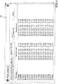
- the data obtaining portion 11A executes the processing to obtain at least one type of data from among the plurality of data (the yield data, the crops components data, the growth data, the soil data) (an obtaining step). For example, when the map call button 59 is selected on the setting screen T1 by an input interface such as a mouse or a keyboard, the data obtaining portion 11A is activated to start the obtaining step. And, the data obtaining portion 11A displays a list T2 of the data (the yield data, the crops components data, the growth data, the soil data) on the management computer 1a as shown in FIG. 4 , with reference to the database (the storage portion) 10 of the server 1b.
- the data obtaining portion 11A calls, from the storage portion 10, the data selected from the list T2 to obtain the data corresponding to one agricultural field from the storage portion 10 (hereinafter may be referred to as an agricultural field data), and then the obtaining step ends.
- the mesh setting portion 11B performs a processing of assigning any one (the agricultural field data) of the crops data and the soil data included in the data obtained by the data obtaining portion 11A to each area Qn in the agricultural field (mesh setting step). For example, when the mesh size is 5m, the mesh setting portion 11B sets the width (a vertical width, a horizontal width) of one side of the area Qn to 5m, divides the agricultural field into a plurality of areas Qn by every 5m, and sets the agricultural field data as the data that is allocated to the area Qn formed by being divided in the mesh size.
- the mesh setting portion 11B averages the data values, and assigns the average value as the divided data D1n corresponding to the area Qn, for example. In addition, when the number of data entering the area Qn is one, the mesh setting portion 11B allocates the data as the divided data D1n corresponding to the area Qn.
- the mesh size can be set by inputting a numerical value of the "mesh size" represented in the basic display portion 53.
- the method of assigning the agricultural field data to the divided data D1n corresponding to the area Qn is not limited to the above-described example.
- the group setting portion 12 sets a group for the divided data D1n for each area Qn allocated by the mesh setting portion 11B. As shown in FIG. 3 , when the management computer 1a or the server 1b store in advance the group setting information representing the relation between the number of groups and the reference values (the upper limit value, the lower limit value) for each group, the group setting portion 12 refers to the group setting information, compares the divided data D1n with the reference value for each group, and assigns a group to each divided data D1n to set a group.
- the first map display portion 51 displays the divided data D1n for each area Qn assigned by the mesh setting portion 11B as the first agricultural field map M1 (a first displaying step).
- the first map display portion 51 displays, on the setting screen T1, the information (the numbers, the characters, the colors, and the like) indicating a group for each divided data D1n set by the group setting portion 12.
- the divided data D1n is divided into a plurality of groups based on the reference value, and the information representing the group is displayed on the setting screen T1, so that the divided data D1n is displayed for each area Qn.
- the raw value of the divided data D1n may be displayed on the setting screen T1.
- the first map display portion 51 finds an agricultural field name, which field the first agricultural field map M1 represents, based on the position (the latitude, the longitude) included in the agricultural field data that is the origin of the divided data D1n, and displays the found name on the basic display portion 53. In this manner, the first agricultural field map M1 displayed by the first map display portion 51 can be known by watching the basic display portion 53.
- the first map display portion 51 may identify the agricultural field name from the file name of the agricultural field data, and may display the identified agricultural field name in the basic display portion 53.
- the spreading setting portion 11C sets the spreading amount of the spread substance for each area Q1n based on the divided data D1n for each area Qn (a spreading setting step). For example, the spreading setting portion 11C sets the spreading amount for each area Qn in accordance with the set spreading amount determined for each group.
- the spreading setting portion 11C sets the set spreading amount Pi as the spreading amount Ri for each area Qn.
- the spreading setting portion 11C sets the set spreading amount P1 for the first group G1 as the spreading amount R1 for each area Qn, sets the set spreading amount P2 for the second group G2 as the spreading amount R2 for each area Qn, sets the set spreading amount P3 for the third group G3 as the spreading amount R3 for each area Qn, sets the set spreading amount P4 for the fourth group G4 as the spreading amount R4 for each area Qn, and sets the set spreading amount P5 for the fifth group G5 as the spreading amount R5 for each area Qn.
- the spreading setting portion 11C associates the spreading amount Pi for each area Qn with the divided data D2n corresponding to the area Qn of the second agricultural field map M2 (the spreading amount Pi for each area Qn is equal to the divided data D2n).
- the second map display portion 52 displays the spreading amount Pi for each area Qn set by the spreading setting portion 11C as a second agricultural field map M2 in association with the position of the agricultural field. That is, the divided data D2n corresponding to the area Qn set by the spreading setting portion 11C is divided into groups preliminarily determined, and then the information (the numbers, the characters, the colors, and the like) indicating the group of the divided data D2n is displayed for each area Qn on the setting screen T1.
- the divided data D2n is divided into a plurality of groups, and the information indicating the group is displayed on the setting screen T1. In this manner, the divided data D2n is displayed for each area Qn. However, the raw value of the divided data D2n (the spreading amount Pi for each area Qn) may be displayed on the setting screen T1.
- the reference values (the upper limit value, the lower limit value) for each group are preliminarily stored in the management computer 1a creating the spreading plan, but the reference values may be freely changed.
- the group setting portion 12 has a reference changer portion 13.
- the reference changer portion 13 is constituted of an electric/electronic component provided in the server 1b, an electric circuit provided in the server 1b, and a computer program and the like stored in the server 1b.
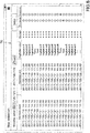
- the reference changer portion 13 changes the reference value for dividing the divided data D1n for each area Qn into the groups. For example, when the reset button 55 displayed on the setting screen T1 is selected by an input interface or the like, the processing of the reference changer portion 13 starts, and the reference changer portion 13 displays the setting screen T3 on the management computer 1a as shown in FIG. 5 .
- the reference setting portion 58 displays the information (the numbers, the characters, the colors, and the like) 58a for identifying the plurality of groups applied to the first agricultural field map (a selected agricultural field map) M1, and displays the reference input portion 58b for inputting the reference values (the upper limit value, the lower limit value) of the groups.
- An administrator or the like can input an arbitrary value (a numeral number) to the reference input portion 58b with used of an input interface.
- the group setting portion 12 (the reference changer portion 13) sets the value inputted to the reference input portion 55b for each group, and stores, in the server 1b, the relation between the groups and the set reference values (the upper limit value, the lower limit value) for each group as the group setting information.
- the reference changer portion 13 is configured to set a reference value for each data. For example, individually for each of the yield data, the crops components data, the growth data, and the soil data, a reference value corresponding to the group can be set. In addition, the reference changer portion 13 can also change the number of groups. For example, the number of groups can be changed from "five" to "twenty" in twenty groups (in twenty steps).
- the spreading amount Pi for each area Qn is set by the spreading setting portion 11C.
- the spreading amount Pi for each area Qn set by the spreading setting portion 11C may be changed.
- the server 1b has an spreading amount changer portion 14.
- the spreading amount changer portion 14 is constituted of an electric/electronic component provided in the server 1b, an electric circuit provided in the server 1b, a computer program and the like stored in the server 1b.
- the spreading amount changer portion 14 changes the spreading amount Pi for each area Qn.
- the processing of the spreading amount changer portion 14 starts.
- the spreading amount changer portion 14 changes the fertilization amount Pi corresponding to the selected area Qn when a predetermined area Qn is selected from among the plurality of areas Qn in the second agricultural field map M2 displayed on the setting screen T1.
- the spreading amount changer portion 14 displays a changer screen T4 on the setting screen T1 as shown in FIG. 6 .
- the changer screen T4 the value of the divided data D1n used for setting the fertilization amount Pi of the selection area Qn is displayed.
- the changer screen T4 displays an input portion (a change input portion) 57 for inputting the fertilization amount Pi corresponding to the area Qn.
- an arbitrary number or the like can be inputted, or any one of numerical values prepared in advance in the change input portion 57 can be selected.
- the spreading amount changer portion 14 converts the inputted numerical value or the selected numerical value into a fertilization amount corresponding to the area Qn, that is, the divided data D2n corresponding to the area Qn.
- the fertilization amount corresponding to the selected area Qn can be changed.
- the agriculture support system includes the data obtaining portion 11A, the mesh setting portion 11B, the spreading setting portion 11C, the first map display portion 51, and the second map display portion 52.
- the agriculture support system includes a group setting portion 12.
- the operator, the management person, or the like can set the spreading amount for each area corresponding to the first agricultural field map M1 while viewing the situation indicated by the first agricultural field map M1.
- an operator, a manager, or the like can set the spreading amount while looking at the yield map, and can confirm that the spreading amount is appropriate while looking at the spreading amount map M2.
- the operator, manager, or the like can easily set the spread amount based on the yield of the yield map M1, while watching the variation in the yield with the yield map M1, and the final confirmation can be made with the spread amount map after the setting.
- the spreading setting portion 11C sets the spreading amount Pi for each area Qn in accordance with the set spreading amount determined for each group. In this manner, since the set spreading amount determined for each group is used, the spreading amount Pi for each area Qn can be easily set for each group. For example, as described above, when the groups are divided into five groups, the first group G1 to the fifth group G5, the spreading amount Pi for each area Qn can be set only with the five set spreading amounts corresponding to the five groups.
- the agriculture support system includes an input portion 54c configured to input a set spreading amount for each group.
- the spreading amount Pi for each area Qn can be easily set simply by inputting the set spreading amount to the input portion 54c.
- the agriculture support system includes the reference changer portion 13 configured to change the reference value with which the divided data D1n and D2n for each area Qn are divided into groups. According to this, since the reference value for setting the groups can be changed, it is possible to change the distribution with respect to the divided data D1n for each area Qn in the first agricultural field map M1 which is a base for setting the spreading amount. In other words, the correspondence between the divided data D1n for each area Qn in the first agricultural field map M1 and the divided data D2n for the area Qn in the second agricultural field map M2 can be changed in accordance with the group reference value, and it is possible to set the spreading amount more precisely by changing the reference value.
- the agriculture support system includes the spreading amount changer portion 14 configured to change the spreading amount Pi for each area Qn set by the spreading setting portion 11C. In this manner, after setting the spreading amount Pi for each area Qn, the spreading amount Pi of an arbitrary area Qn can be changed.
- the first spreading planning portion 11 may be provided with the auto determiner portion 11D.
- the auto determiner portion 11D is constituted of an electric/electronic component provided in the server 1b, an electric circuit provided in the server 1b, a computer program stored in the server 1b, and the like.
- the auto determiner portion 11D automatically determines the set spreading amount to be inputted to the spreading inputting portion (an input portion) 54c of the setting screen T1.
- the set spreading amount of the first input portion 54c1 is referred to as a "first set spreading amount P1”
- the set spreading amount of the second input portion 54c2 is referred to as a “second set spreading amount P2”
- the set spreading amount of the third input portion 54c3 is referred to as a “third set spreading amount P3”
- the set spreading amount of the fourth input portion 54c4 is referred to as a "fourth set spreading amount P4"
- the set spreading amount of the fifth input portion 54c5 is referred to as a "fifth set spreading amount P5".
- the auto determiner portion 11D displays, on the setting screen T1, an agricultural field-unit input portion 300 to which a spreading amount (a field-unit spreading amount) per agricultural field to be spread is inputted.
- a spreading amount a field-unit spreading amount per agricultural field to be spread.
- the auto determiner portion 11D assigns the agricultural field-unit spreading amount to the first input portion 54c1, the second input portion 54c2, the third input portion 54c3, the fourth input portion 54c4, the fifth input portion 54c5 so that the sum of the first set spreading amount P1, the second set spreading amount P2, the third set spreading amount P3, the fourth set spreading amount P4, and the fifth set spreading amount P5 matches with the agricultural field-unit spreading amount.
- the auto determiner portion 11D sets the first set spreading amount P1 to the maximum and sets the fifth set spreading amount P5 to the minimum, and assigns the set spreading amount to each of the remaining second set spreading amount P2, the third set spreading amount P3, and the fourth set spreading amount P4.
- the auto determiner portion 11D it is possible to set the set spreading amount set for each group simply by inputting the agricultural field-unit spreading amount of the spread substance to be spread per field by the operator.
- the auto determiner portion 11D described above sets the set spreading amount set for each group by inputting the agricultural field-unit spreading amount, but instead of this, the setting spreading amount for every group may be set by inputting the maximum value and the minimum value of the spreading amount per predetermined area.
- the auto determiner portion 11D displays, on the setting screen T1, an area-unit inputting portion 301 to which a spreading amount (unit-area spreading amount) spread per 10are (10a) is inputted.
- the area-unit inputting portion 301 can receive the maximum value (the maximum spreading amount) of the spread substance per predetermined area and the minimum value (the minimum spreading amount) of the spread substance per predetermined area.
- the auto determiner portion 11D sets the first set spreading amount P1 to the maximum spreading amount and sets the fifth set spreading amount P5 to the minimum spread amount as shown in FIG. 11B .
- the auto determiner portion 11D determines the second set spreading amount P2 as a value obtained by subtracting a predetermined amount from the maximum spreading amount, determines the fourth set spreading amount P4 as a value obtained by adding the predetermined amount to the minimum spreading amount, and then, sets the third set spreading amount P3 is to be larger than the fourth set spreading amount P4 and less than the second set spreading amount P2.
- the auto determiner portion 11D it is possible to set the set spreading amount set for each group simply by inputting the maximum value and the minimum value of the unit-area spreading amount of the spread substance to be spread per predetermined area by the operator.
- a spreading plan is created using at least one data (one type of data) among the crops data (the yield data, the crops components data, the growth data, the soil data).
- the spreading plan may be created using at least two data (two types of data) among the crops data (the yield data, the crops components data, the growth data, the soil data).
- the server 1b includes a second spreading planning portion 15.
- the second spreading planning portion 15 is constituted of an electric/electronic component provided in the server 1b, an electric circuit provided in the server 1b, a computer program stored in the server 1b, and the like.
- the second spreading planning portion 15 creates a spreading plan for the spreading on the agricultural field using at least two data (two types of data) among the crops data (the yield data, the crops components data, the growth data, the soil data).
- a menu screen for selecting a menu or the like is displayed on the display portion 40 of the management computer 1a.
- the management computer 1a requests the server 1b to create a spreading plan.
- the second spreading planning portion 15 of the server 1b displays a setting screen T5 on the management computer 1a.
- the setting screen T5 includes a first map display portion 51 and a second map display portion 52.
- the first map display portion 51 displays a map obtained from the data to be referred to in creating the spreading plan.
- the first map display portion 51 displays the first agricultural field map created individually [the yield map, the crops component map (the moisture map, the taste map, and the like), the growth map, the soil map] M1] based on each of the yield data, the crops components data (the moisture content rate, the protein content rate), the growth data, and the soil data.
- the first map display portion 51 includes a map display portion 51A configured to display the first agricultural field map M1, and includes a map display portion 51B configured to display the first agricultural field map M1 different from the map display portion 51A. That is, the first map display portion 51 displays at least two first agricultural field maps M1 each having different data.
- the second map display portion 52 displays a second agricultural field map (the fertilization amount map) M2 including the spreading amount that is set based on the first agricultural field map M1 displayed on the first map display portion 51.
- the setting screen T5 includes a data display portion 60 and a spreading planning portion 61.
- the data display portion 60 displays at least two pieces of divided data Dlnj (j ⁇ 2 or more) on the distribution map R1 having a plurality of indexes.
- the data display portion 60 first sets the index of the distribution map R1 to a first index corresponding to the vertical axis (Y coordinate) and to a second index corresponding to the horizontal axis (X coordinate) in accordance with the number of the first agricultural field maps M1.
- the data display portion 60 associates the divided data D1n1 in the area Qn of the first one of the first agricultural field maps M1 with the Y coordinate of the distribution map R1, associates the divided data D1n1 in the area Qn of the second one of the first agricultural field maps M1 with the X coordinate of the distribution map R1, and the divided data D1n1 and the divided data D1n2 in the same area Qn are plotted on the distribution map R1. That is, when there are two first agricultural field maps M1, the data display portion 60 displays the divided data D1n1 and D1n2 in a two-dimensional graph.
- the data display portion 60 displays, on distribution map R1, the relation between the yield and the protein content in the identical area Qn in the yield map and the taste map.
- the spreading planning portion 61 is a portion capable of inputting information necessary for setting the spreading amount, and includes a name display portion 61a, a graph setting portion 61b, a group display portion 61c, a spread input portion (input portion) 61d, and a cost display portion 61e.
- the name display portion 61a displays the name of the first agricultural field map M1 selected by the first map display portion 51.
- the graph setting portion 61b is a portion configured to set the number of divisions of the plot area PA in the plot area PA of the distribution map R1. In other words, the graph setting portion 61b is a portion configured to divide the plot area PA of the distribution map R1 into a predetermined range.
- the graph setting portion 61b is capable of setting the number of divisions in the Y coordinate direction and the number of divisions in the X coordinate direction in the plot area PA.
- the graph setting portion 61b divides the plot area PA vertically into two parts and horizontally into three parts, into six parts in total.
- the graph setting portion 61b is configured to set the maximum value and the minimum value of the first index (Y coordinate) and the maximum value and the minimum value of the second index (X coordinate) in the distribution map R1.
- the group display portion 61c displays a plurality of groups set in the distribution map R1. As described above, when the plot area PA of the distribution map R1 is divided in plural, the same number of groups as the number of divisions of the plot area PA are displayed. In the distribution map R1, when the plot area PA is divided into six predetermined areas (E1 to E6), the group display portion 61c displays the groups corresponding to the predetermined areas E1 to E6, that is, the "first group G1" corresponding to the predetermined area E1, the "second group G2" corresponding to the predetermined area E2, the “third group G3" corresponding to the predetermined area E3, the "fourth group G4" corresponding to the predetermined area E4, the "fifth group G5" corresponding to the predetermined area E5, and the "sixth group G6" corresponding to the predetermined area E6.
- the boundary lines L1 of the predetermined areas E1 to E6 are displayed.
- the boundary lines L1 indicate the upper limit values or the lower limit values of the predetermined ranges E1 to E6.
- the boundary lines L1 can be moved in the vertical direction and in the horizontal direction on the distribution map R1 with use of an input interface or the like, whereby the upper limit values or the lower limit values of the groups can be set.
- the spread input portion 61d is a portion for inputting a set spreading amount that is set for each group.
- the spread input portion 61c includes a first input portion F1 that inputs a set spreading amount corresponding to the first group G1, a second input portion F2 that inputs a set spreading amount corresponding to the second group G2, a third input portion F3 that inputs a set spreading amount corresponding to the third group G3, a fourth input portion F4 that inputs a set spreading amount corresponding to the fourth group G4, a fifth input portion F5 that inputs a set spreading amount corresponding to the fifth group G5, and a sixth input portion F6 that inputs a set spreading amount corresponding to the sixth group G6.
- the value (the set spreading amount) to be inputted to the spreading inputting portion 61d may be a spreading amount per unit area, or may be a value arbitrarily determined.
- the cost display portion 61 e displays the purchase cost of the spread substance for each group based on the set spreading amount inputted to the spreading input portion 61d. For example, the purchase cost of the spread substance for each group is calculated and displayed based on the purchase cost of the spread substance per kilogram.
- an administrator, an operator, or the like can set the spreading amount in the agricultural field for each predetermined area with use of the setting screen T5 displayed on the display portion 40 of the management computer 1a.
- the second spreading planning portion 15 includes a data obtaining portion 15A, a mesh setting portion 15B, a spreading setting portion 15C, and a group setting portion 16.
- the group setting portion 16 is constituted of an electric/electronic component provided in the server 1b, an electric circuit provided in the server 1b, a computer program stored in the server 1b, and the like.
- the data obtaining portion 15A executes a process of obtaining data including at least two types of the data relating to the crops planting (the obtaining step). For example, when the map call button 59 is selected by the input interface on the setting screen T5, the data obtaining portion 15A is activated to start the obtaining step, and the data obtaining portion 15A refers to the database (the storage portion) of the server 1b, and then displays a list T6 of the data (the yield data, the crops components data, the growth data, the soil data) is displayed on the management computer 1a as shown in FIG. 8 .
- the list T6 can select two types of data.
- the first one of the data is data corresponding to the Y coordinate in the distribution map R1
- the second one of the data is the X coordinate in the distribution map R1.
- the data obtaining portion 15A calls, from the storage portion 10, the data selected from the list T6 to obtain the agricultural field data corresponding to two agricultural fields from the storage portion 10, and then the obtaining step ends.
- the mesh setting portion 15B performs a process of assigning at least two types of agricultural field data obtained by the data obtaining portion 15A to each area Qn in the agricultural field (the mesh setting step). For example, the mesh setting portion 15B assigns the divided data D1n1 of the first one of the field data (the first field data) to each area Qn in the agricultural field, and assigns the divided data D1n2 of the second one of the field data (the second field data) is assigned to each area Qn in the agricultural field.
- the method of assigning the area Qn to the first field data and the second field data is the same as that of the mesh setting portion 11B.
- the first map display portion 51 displays, as the first agricultural field map M1, the divided data Dlnj (j ⁇ 2) for each area Qn assigned by the mesh setting portion 15B.
- the map display portion 51A of the first map display portion 51 displays the first agricultural field map M1 indicated by the divided data D1n1 corresponding to the area Qn
- the map display portion 51B of the first map display portion 51 displays the first agricultural field map M1 indicated by the divided data D1n2 corresponding to the area Qn.
- the map display portion 51A displays the yield map when the first field data is the yield data.
- the map display portion 51B displays the taste map (the map which shows protein content rate), when the second field data is the crops contents data which shows the protein content rate.
- the data display portion 60 displays, on the distribution map R1, the divided data D1n1 corresponding to the area Qn of the first agricultural field map M1 and the divided data D1n2 corresponding to the area Qn of the first agricultural field map M1.
- the data display portion 60 displays, as a two-dimensional distribution map R1, the relation between the yield of the area Qn of the yield map (the division data D1n1) and the protein content rate of the area Qn of the taste map (the division data D1n2), for example.
- the group setting portion 16 sets the groups for divided data Dnj corresponding to the same area Qn among at least two types of divided data Dnj.
- the group setting portion 16 sets the divided data [D1n2, D1n1] that falls within the predetermined range E1 to the first group G1, sets the divided data that falls within the predetermined range E2 to the second group G2, sets the divided data that falls within the predetermined range E3 to the third group G3, sets the divided data that falls within the predetermined range E4 to the fourth group G4, sets the divided data that falls within the predetermined range E5 to the fifth group G5, and sets the divided data that falls within the predetermined range E6 to the sixth group G6.
- the group setting portion 16 includes a threshold setting portion 18.
- the threshold setting portion 18 is constituted of an electric/electronic component provided in the server 1b, an electric circuit provided in the server 1b, a computer program stored in the server 1b, and the like.
- the reference values (the upper limit values or the lower limit values) of the predetermined ranges E1 to E6 can be changed by moving the boundary lines L1 of the distribution map R1 with use of the input interface.
- the threshold setting portion 18 reads the Y coordinate value (a set value to the Y coordinate) in the boundary line L1a after the movement, and sets the lower limit values in the first index of the predetermined areas E1, E3, and E5 and sets the upper limit value in the first index of the predetermined areas E2, E4, and E6, as the set values to the Y coordinate. That is, the threshold setting portion 18 sets the lower limit values of the reference values in the first index of the groups G1, G3, and G5 and sets the upper limit values of the reference values in the second index of the groups G2, G4, and G6.
- the threshold setting portion 18 reads the X coordinate value (a set value to the X coordinate) in the boundary line L1b after the movement, and sets the upper limit values in the second index of the predetermined areas E3 and E4 and sets the lower limit value in the second index of the predetermined areas E5 and E6, as the set values to the X coordinate. That is, the threshold setting portion 18 sets the lower limit values of the reference values in the second index of the groups G3 and G4 and sets the upper limit values of the reference values in the second index of the groups G2, G4, and G6.
- the setting screen T5 allows to set the groups G1 to G6 with use of the boundary lines L1 and the like while viewing the distribution map R1.
- the spread setting portion 15C sets the spreading amount of the spread substance for each area Qn based on at least two types of divided data Dlnj assigned to each area Qn (the spreading setting step). For example, the spread setting portion 15C sets the spreading amount for each area Qn in accordance with the set spreading amount determined for each group.
- the spread setting portion 15C sets the set spreading amount Pi as the spreading amount Ri for each area Qn.
- the second map display portion 52 displays the spreading amount Pi for each area Qn set by the spread setting portion 15C as the second agricultural field map M2 in correspondence with the position of the agricultural field. That is, the raw value of the divided data D2n (the spreading amount Pi for each area Qn) corresponding to the area Qn set by the spreading setting portion 15C is displayed on the setting screen T5.
- the divided data D2n may be divided into a plurality of groups set by the group setting portion 12, and the information indicating the group may be displayed on the setting screen T5, thereby displaying the divided data D2n for the area Qn.
- the agriculture support system includes the data obtaining portion 15A, the mesh setting portion 15B, and the spreading setting portion 15C.
- the operator, the administrator, or the like can set the spreading amount for each area corresponding to the first agricultural field map M1 while watching the situation indicated by the first agricultural field map M1.
- an operator, a manager, or the like can set the spreading amount while watching the yield map, and can check whether the spreading amount is appropriate while watching the spreading amount map M2.
- the operator, manager, or the like can easily set the spread amount based on the yield of the yield map M1, while watching the variation in the yield in the yield map M1, and the final confirmation can be made with the spread amount map after the setting.
- the agriculture support system includes the group setting portion 16, and the spread setting portion sets the spreading amount for each area based on the group set by the group setting portion 16.
- the data when two types of data are selected, the data can be set to the plurality of groups corresponding to the divided data corresponding to the same area Qn, the divided data being included in the same data.
- the spreading amount Pi of the area Qn can be easily set for each group. For example, as described above, the groups corresponding to the same area in the yield map and in the taste map can be set.
- the spreading amount Pi of the area Qn can be set with only five set spreading amounts corresponding to the five groups.
- the agriculture support system includes the data display portion 60.
- the data display portion 60 can display, as a distribution map, two divided data in the yield map and in the taste map, for example. In this manner, an operator, an administrator, or the like can grasp easily the relation between the yield and the taste by watching a distribution map.
- the data display portion 60 displays a distribution map that represents the first index on the vertical axis and the second index on the horizontal axis among the plurality of indexes, and the group setting portion 16 displays groups for each predetermined area shown in the distribution map. In this manner, an operator, a manager, or the like can easily set the group while watching the distribution map in consideration of the variation shown in the distribution map while grasping the relation between the yield and the taste.
- the agriculture support system includes the threshold setting portion 18 configured to set an upper limit value or a lower limit value of a predetermined area. According to this configuration, the threshold value setting portion 18 can easily set, on the distribution diagram, the upper limit value and the lower limit value corresponding to the group.
- the agriculture support system includes the spreading amount changer portion 14. According to this configuration, after setting the spreading amount Pi for each area Qn, the spreading amount Pi of an arbitrary area Qn can be changed.
- the agriculture support system includes the map display portion 52. According to this configuration, the spreading amount Pi for each area Qn can be displayed as an agricultural field map in correspondence with the position in the agricultural field, and the tendency of the spreading amount to the agricultural field can be grasped.
- the spreading amount set by the spreading setting portion 15C can be changed in the setting screen T5.
- the processing of the spreading amount changer portion 14 starts.
- the spreading amount changer portion 14 changes the fertilization amount Pi corresponding to the selected area Qn.
- the operation of the spreading amount changer portion 14 is the same as the operation of the above-described embodiment.
- the mesh setting portion 11B assigns the divided data D1n to the area Qn. However, when the divided data D1n does not exist in the area Qn, that is, when the divided data D1n is missing, it is preferred to interpolate a value of the portion where the divided data D1n does not exist (missing data).
- the mesh setting portion 11B sets, as a value of the divided data D15, the average value of the divided data D11 to D14 and the divided data D16 to D19 in the areas (Q1 to Q4, Q6 to Q9) surrounded by the area Q5, for example. That is, when there is the missing data, the mesh setting portion 11B interpolates the missing data with use of the divided data D1n of the area Qn around the area Qn of the missing data. Similar to the mesh setting portion 11B, the mesh setting portion 15B may preferably interpolate the missing data.
- the server 1b includes the spread transmitter portion 19.
- the spread transmission portion 19 is constituted of an electric/electronic component provided in the server 1b, an electric circuit provided in the server 1b, a computer program stored in the server 1b, and the like.
- the spread transmitter portion 19 transmits the spreading amount Pi for each area Qn, that is, transmits, to the spreader 70, the position information indicating a position of the area Qn and the spreading amount Pi.
- the spreader 70 includes the position detector device 70a configured to detect a position (the latitude, the longitude) based on a signal from a positioning satellite or the like, and includes a communication device 70b configured to receive the spreading amount Pi for each area Qn transmitted from the spread transmitter portion 19 or the like.
- the spreader machine 70 can spread the spread substance corresponding to the spreading amount Pi of the area Qn based on the spreading plan.
- FIG. 12 is a diagram showing an agriculture support system according to a second embodiment of the present invention.
- the agriculture support system according to the second embodiment is a system that carries out a spreading plan by linking at least two servers.
- the description of configurations same as those of the first embodiment is omitted.
- the agriculture support system includes a server 1b and a server 1d.
- the server 1d has an operation plan creating portion 310.
- the operation plan creating portion 310 is constituted of an electric/electronic component provided in the server 1b, an electric circuit, a computer program or the like stored in the server 1b.
- the operation plan creating portion 310 creates an operation plan corresponding to the spreading plan.
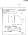
- the operation plan creating portion 310 displays an operation plan screen T10 on the display portion 40 of the management computer 1a as shown in FIG. 13 .
- the operation plan screen T10 includes a date setting portion 320 for setting a date for performing an agricultural operation, an agricultural field selecting portion 321 for selecting an agricultural field, an operation selecting portion 322 for selecting the agricultural operation, an operator selecting portion 323 for selecting an operator, a time setting portion 324 for setting an operation time, a machine selecting portion 325 for selecting a machine, and a spreading selecting portion 326 for setting the spread substance.
- the agricultural field selecting portion 321 displays a agricultural field map different from the first agricultural field map M1 and the second agricultural field map M2, for example, displays an aerial image of the agricultural field, and selects an agricultural field on which agricultural operation is performed with use of an input interface such as a mouse or a keyboard.
- the operation selecting portion 322 can set various types of agricultural operation including the spreading operation (the spreading of fertilizer, the spreading of cropping material).
- the operator selecting portion 323 displays a list of operators registered in advance, and is capable of selecting the operator name who performs the agricultural operation.
- the time setting portion 324 is capable of inputting the operation time for performing the agricultural operation, for example, inputting an operation start time and an operation finish time.
- the machine selecting portion 325 is capable of selecting a machine to be used in the agricultural operation.
- the spreading selecting portion 326 is capable of selecting the name of the spread substance.
- the operation plan creating portion 310 is capable of creating an operation plan including the date, the agricultural field, the agricultural operation, the operator, the operation time, the machine, and the spread substance.
- the operation plan created by the operation plan creating portion 310 can be stored in the database (the storage portion) 311 and can be confirmed by the administrator or the operator with use of the management computer 1a or the like.
- the server 1d (the operation plan creating portion 310) is capable of registering the spread substance.
- the server 1d includes a spread substance registering portion 312.
- the spread substance registering portion 312 is constituted of an electric/electronic component provided in the server 1d, an electric circuit, a computer program stored in the server 1b.
- the spread substance registering portion 312 displays the spread substance registering screen T11 on the display portion 40 of the management computer 1a as shown in FIG. 14 .
- the spread substance registering screen T11 includes a name inputting portion 330 for inputting the name of the spread substance, a manufacture inputting portion 331 for inputting the manufacturer of the spread substance, a usage inputting portion 332 for inputting the usage of the spread substance, and a components inputting portion 333 for inputting three major elements such as Nitrogen (N), Phosphorus (P), Potassium (K), and the like, a weight inputting portion 334 for inputting the weight per bag, and a criterion spreading inputting portion 335 for inputting a spreading amount per a predetermined area (a criterion spreading amount).
- N Nitrogen
- P Phosphorus
- K Potassium
- the spread substance registering portion 312 is capable of registering, to the server 1d, the spread substance registration information such as the name of spread substance, the manufacturer, the usage, the three major components, the weight, and the criterion spreading amount.
- the spread substance registration information registered by the spread substance registering portion 312 can be stored in the database (the storage portion) 313, and can be confirmed by an administrator or an operator with use of the management computer 1a or the like.
- the server 1b is capable of referring to and obtaining the spread substance registration information stored in the database (the storage portion) 313 at the time of preparing a spreading plan.
- the auto determiner portion 11D of the server 1b automatically determines the set spreading amount to be inputted to the spreading inputting portion (the inputting portion) 54c of the setting screen T1, using the spread substance registration information stored in the database 313 of the server 1d.
- the auto determiner portion 11D refers to the spread substance registration information stored in the database 313 of the server 1d, and obtains the criterion spreading amount of the same spread substance shown in the name in the spreading planning portion 54 on the setting screen T1 (the name of the spread substance).
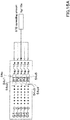
- the auto determiner portion 11D obtains the criterion spreading amount from the server 1d, as shown in FIG 15A , the auto determiner portion 11D determines that the third setting spreading amount P3 of the third input portion 54c3 located in the middle in the spreading input portion 54c employs the criterion spreading amount obtained from the server 1d.
- the auto determiner portion 11D determines that the second set spreading amount P2 employs a value obtained by adding a predetermined amount to the third set spreading amount (the criterion spreading amount) P3.
- the auto determiner portion 11D determines that the first set spreading amount P1 employs a value obtained by adding a predetermined amount to the criterion spreading amount P3, the value being larger than the second set spreading amount P2.
- the auto determiner portion 11D determines that the fourth set spreading amount P4 is a value obtained by subtracting a predetermined amount from the criterion spreading amount P3, and determines that the fifth set spreading amount P5 is a value obtained by subtracting the predetermined amount from the criterion spreading amount P3, the value being smaller than the fourth set spreading amount P4.
- the criterion spreading amount registered in the server 1d is set to be the middle value of the set spreading amount (the third set spreading amount P3), and another set spreading amount is set by increasing or decreasing the middle value.
- the auto determiner portion 11D described above sets the criterion spreading amount to be a middle value of the set spreading amount
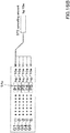
- the criterion spreading amount may be set to be the maximum value. In that case, when the auto determiner portion 11D obtains the criterion spreading amount from the server 1d, the auto determiner portion 11D determines, as illustrated in FIG. 15B , determines that the set spreading amount P1 of the first input portion 54c1 on the upper position employs the criterion spreading amount obtained from the server 1d.
- the auto determiner portion 11D determines that the second set spreading amount P2 employs a value obtained by subtracting a predetermined amount from the first set spreading amount (the criterion spreading amount) P1, and determines that the third set spreading amount P3 employs a value obtained by subtracting the predetermined amount from the criterion spreading amount P1, the value being smaller than the second set spreading amount P2.
- the auto determiner portion 11D determines that's the fourth set spreading amount P4 employs a value obtained by subtracting a predetermined amount from the criterion spreading amount P1, the value being smaller than the third set spreading amount P3, and determines that the fifth set spreading amount P5 employs a value obtained by subtracting the predetermined amount from the criterion spreading amount P1, the value being smaller than the fourth set spreading amount P4.
- the criterion spreading amount registered in the server 1d is set to be the maximum value of the set spreading amount (the first setting spreading amount P1), and another set spreading amount can be set by sequentially subtracting the predetermined value from the maximum value.
- the auto determiner portion 11D described above sets the set spreading amount only by increasing or decreasing the predetermined amount with respect to the criterion spreading amount.
- the set spreading amount may be set based on a combination between the criterion spreading amount, the maximum spreading amount, and the minimum spreading amount inputted to the area-unit inputting portion 301. In that case, when the auto determiner portion 11D obtains the criterion spreading amount from the server 1d, the auto determiner portion 11D determines that the third set spreading amount P3 employs the criterion spreading amount as shown in FIG. 15C .
- the auto determiner portion 11D sets the first set spreading amount P1 to be the maximum spreading amount inputted to the area-unit inputting portion 301, and sets the fifth set spreading amount P5 to be the minimum spreading amount inputted to the area-unit inputting portion 301.
- the auto determiner portion 11D determines that the second set spreading amount P2 employs a value obtained by subtracting a predetermined amount from the maximum spreading amount, and determines that the fourth set spreading amount P4 employs a value obtained by adding the predetermined amount to the minimum spreading amount.
- the criterion spreading amount registered in the server 1d is set to be the middle value in the set spreading amount, while the value inputted by the operator or the like to the area-unit inputting portion 301 is set to be the maximum value and the minimum value of the set spreading amount.
Landscapes
- Life Sciences & Earth Sciences (AREA)
- Engineering & Computer Science (AREA)
- Radar, Positioning & Navigation (AREA)
- Remote Sensing (AREA)
- Soil Sciences (AREA)
- Environmental Sciences (AREA)
- Physics & Mathematics (AREA)
- General Physics & Mathematics (AREA)
- Business, Economics & Management (AREA)
- Automation & Control Theory (AREA)
- Marine Sciences & Fisheries (AREA)
- General Health & Medical Sciences (AREA)
- Agronomy & Crop Science (AREA)
- Mining & Mineral Resources (AREA)
- Mechanical Engineering (AREA)
- Health & Medical Sciences (AREA)
- Economics (AREA)
- Animal Husbandry (AREA)
- Human Resources & Organizations (AREA)
- Marketing (AREA)
- Primary Health Care (AREA)
- Strategic Management (AREA)
- Tourism & Hospitality (AREA)
- General Business, Economics & Management (AREA)
- Theoretical Computer Science (AREA)
- Management, Administration, Business Operations System, And Electronic Commerce (AREA)
Abstract
Description
- The present invention relates to an agriculture support system, to an agriculture support system, and to an agriculture support method.
- A technique for setting a fertilizing amount to an agricultural field disclosed
Patent document 1 is previously known. - The fertilization amount setting method disclosed in
Patent Document 1 includes a yield difference calculation step for calculating a yield difference that is a difference between a target yield of the grain and an actual result value of the yield of the grain, and a taste difference calculation step for calculating a taste difference that is a difference between a target taste value of the grain and an actual result value of the taste value. The method sets the fertilization amount by inputting, to a mobile terminal or the like, a weighting value for the yield difference calculated at the yield difference calculation step and for the taste difference calculated at the taste difference calculation step. - [Patent Document 1] Japanese Unexamined Patent Application Publication No.
2013-234935 - In the fertilization amount setting method of
Patent Document 1, the fertilization amount is calculated by inputting a weight value to the mobile terminal, paying attention to the fact that the yield and the taste are in the trade-off relation. Although the fertilization amount setting method ofPatent Document 1 is a useful technique because the fertilization amount can be set appropriately, the fertilization amount cannot be set while grasping variations of the yield in the entire field. In addition, inpatent document 1, it is difficult to divide an agricultural field into predetermined divisions and to set the fertilization amounts with respect to the divided areas. - In view of the problem mentioned above, the present invention intends to provide an agriculture support system, an agriculture support device, and an agriculture support method capable of easily setting a spreading amount of the spread substance.
- Technical means of the present invention for solving this technical problem is characterized by the following points.
- An agriculture support system includes: a data obtaining device to obtain at least one type of data among a plurality of types of data relating to planting of crops; a mesh setting device to allocate, as divided data, the data obtained by the data obtaining device to each of areas of an agricultural field in which the crops are planted; a first map display to relate, to a location of the agricultural field, the divided data allocated to each of the areas by the mesh setting device and to display the divided data as a first field map; a spreading setting device to set a spreading amount of spread substance in each of the areas based on the divided data of each of the areas; and a second map display to relate, to the location of the agricultural field, the spreading amount set to each of the areas by the spreading setting device and to display the spreading amount as a second field map.
- The agriculture support system includes a grouping device to group the divided data of each of the areas, the divided data being allocated by the mesh setting device. The spreading setting device sets the spreading amount in each of the area based on the groups determined in each of the areas by the grouping device.
- In the agriculture support system, the spreading setting device sets the spreading amount in each of the areas based on a set spreading amount determined to each of the groups.
- The agriculture support system includes an input device to input the set spreading amount for each of the groups.
- The agriculture support system includes a criterion changer device to change a criterion value used for grouping the divided data of each of the areas.
- In the agriculture support system, when there is another area to which the divided data is not allocated, the mesh setting device interpolates the divided data.
- The agriculture support system includes a spreading amount changer device to change the spreading amount for each of the areas. the spreading amount being set by the spreading setting device.
- The agriculture support system includes a spreading machine to spread the spread substance; and a spreading transmitter device to transmit the spreading amount in each of the areas to the spreading machine configured to spread the spread substance.
- The agriculture support system includes an auto determining device to automatically determine the set spreading amount that is inputted to the input device.
- In the agriculture support system, the plurality of types of data include any of yields of the crops, taste of the crops, growing state of the crops, and components of soil.
- An agriculture support device includes: a data obtaining device to obtain at least one type of data among a plurality of types of data relating to planting of crops; a mesh setting device to allocate, as divided data, the data obtained by the data obtaining device to each of areas of an agricultural field in which the crops are planted; a first map display to relate, to a location of the agricultural field, the divided data allocated to each of the areas by the mesh setting device and to display the divided data as a first field map; a spreading setting device to set a spreading amount of spread substance in each of the areas based on the divided data of each of the areas; and a second map display to relate, to the location of the agricultural field, the spreading amount set to each of the areas by the spreading setting device and to display the spreading amount as a second field map.
- An agriculture support method includes: a data obtaining step for obtaining at least one type of data among a plurality of types of data relating to planting of crops; a mesh setting step for allocating, as divided data, the data obtained at the data obtaining step to each of areas of an agricultural field in which the crops are planted; a first displaying step for relating, to a location of the agricultural field, the divided data allocated to each of the areas at the mesh setting step and displaying the divided data as a first field map; a spreading setting step to set a spreading amount of spread substance in each of the areas based on the divided data of each of the areas; and a second displaying step for relating, to the location of the agricultural field, the spreading amount set to each of the areas at the spreading setting step and displaying the spreading amount as a second field map.
- An agriculture support system includes: a data obtaining device to obtain at least two types of data among a plurality of types of data relating to planting of crops; a mesh setting device to allocate, as divided data, the at least two types of data obtained by the data obtaining device to each of areas of an agricultural field in which the crops are planted; and a spreading setting device to set a spreading amount of spread substance in each of the areas based on at least two types of the divided data allocated to each of the areas by the mesh setting device.
- The agriculture support system includes a grouping device to group the divided data of identical one of the areas among the at least two types of divided data. The spreading setting device sets the spreading amount in each of the area based on the groups determined by the grouping device.
- The agriculture support system includes a data display to display the at least two types of divided data on a distribution map that has at least a plurality of indexes.
- The agriculture support system includes a grouping device to group the divided data of identical one of the areas among the at least two types of divided data. The data display displays the distribution map that has a vertical line serving as a first index of the plurality of indexes and has a horizontal line serving as a second index. The grouping device performs the grouping a predetermined range displayed on the distribution map.
- The agriculture support system includes a threshold setting device to set an upper limit or a lower limit of the predetermined range.
- The agriculture support system includes a spreading amount changer device to change the spreading amount set to each of the areas by the spreading setting device.
- The agriculture support system includes a map display to relate, to the location of the agricultural field, the spreading amount set to each of the areas by the spreading setting device and to display the spreading amount as a field map.
- The agriculture support system includes a spreading transmitter device to transmit the spreading amount in each of the areas to the spreading machine configured to spread the spread substance.
- In the agriculture support system, the plurality of types of data include any of yields of the crops, taste of the crops, growing state of the crops, and components of soil.
- An agriculture support device includes: a data obtaining device to obtain at least two types of data among a plurality of types of data relating to planting of crops; a mesh setting device to allocate, as divided data, the at least two types of data obtained by the data obtaining device to each of areas of an agricultural field in which the crops are planted; and a spreading setting device to set a spreading amount of spread substance in each of the areas based on at least two types of the divided data allocated to each of the areas by the mesh setting device.
- An agriculture support method includes: a data obtaining step for obtaining at least two types of data among a plurality of types of data relating to planting of crops; a mesh setting step for allocating, as divided data, the at least two types of data obtained at the data obtaining step to each of areas of an agricultural field in which the crops are planted; and a spreading setting step for setting a spreading amount of spread substance in each of the areas based on at least two types of the divided data allocated to each of the areas at the mesh setting step.
- According to the present invention, it is possible to easily set the spreading amount of spread substance for each area.
-
-
FIG. 1 is a view illustrating an agriculture support system according to a first embodiment of the present invention. -
FIG. 2 is a view illustrating a setting screen T1 according to the first embodiment. -
FIG. 3 is a view illustrating a relation between divided data D1n and D2n and groups according to the first embodiment. -
FIG. 4 is a view illustrating a list T2 according to the first embodiment. -
FIG. 5 is a view illustrating a group setting screen T3 according to the first embodiment. -
FIG. 6 is a view illustrating a state where a change screen T4 is displayed on the setting screen T1 according to the first embodiment. -
FIG. 7 is a view illustrating a setting screen T5 according to the first embodiment. -
FIG. 8 is a view illustrating a list T6 according to the first embodiment. -
FIG. 9 is a view illustrating the way of filling a blank of data according to the first embodiment. -
FIG. 10A is a view illustrating the setting screen T1 including a field portion input portion according to the first embodiment. -
FIG. 10B is a view illustrating the setting screen T1 including an area portion input portion according to the first embodiment. -
FIG. 11A is a view illustrating the way of setting a set spreading amount based on a field portion spreading amount according to the first embodiment. -
FIG. 11B is a view illustrating the way of setting the set spreading amount based on the maximum spreading amount and the minimum spreading amount per a predetermined area according to the first embodiment. -
FIG. 12 is a view illustrating an agriculture support system according to a second embodiment of the present invention. -
FIG. 13 is a view illustrating an operation planning screen T10 according to the second embodiment. -
FIG. 14 is a view illustrating a spread substance registering screen T11 according to the second embodiment. -
FIG. 15A is a view illustrating the setting of a case where a criterion spread amount is determined to a middle value of the set spreading amount according to the second embodiment. -
FIG. 15B is a view illustrating the setting of a case where the criterion spread amount is determined to the maximum value of the set spreading amount according to the second embodiment. -
FIG 15C is a view illustrating the way of setting the set spreading amount based on the criterion spread amount, the maximum spreading amount, and the minimum spreading amount according to the second embodiment. - Hereinafter, an embodiment of the present invention will be described with reference to the drawings as appropriate.
-
FIG. 1 shows an agriculture support system. The agriculture support system is a system that provides support relating to the spreading of the spread substance, for example. The spread substance (the spread agent) is, for example, chemical agents (agrochemicals), fertilizers, or the like. The agriculture support system includes a computer. - The computer includes, for example, a management computer 1a installed in a farmer's house, a farming company, or the like, and includes a
server 1b to which the management computer 1 a can be connected. The management computer 1a is, for example, a personal computer (PC) assigned to an administrator or an operator. The management computer 1a may be a mobile terminal such as a smartphone, a tablet, or a PDA. - As shown in
FIG. 1 , theserver 1b is an agriculture support device that supports the agriculture operation, and is configured to obtain various types of data (information) related to the agriculture. Theserver 1b obtains data related to the cropping, for example, the data such as the crops data and the soil data. The crops data and the soil data are data obtained through the remote sensing method, for example. - The crops data is data related to the crops planted in the agricultural field, for example, the data indicating the yield of the crops in the agricultural field (the yield data), the data indicating the chemical composition of the crops (the crops components data), and the data indicating the growth status of the crops (the growth data). The crops components data is, for example, the water content rate of the crops (the moisture content), the taste of the crops (the protein content), and the like. The soil data is data related to the soil in the agricultural field, for example, the data indicating the chemical compositions of the soil (the soil components data).
- The yield data and the crops components data are detected by, for example, the harvester (harvesting machine) 20 in harvesting the crops. The harvesting
machine 20 is a combine configured to harvest the crops. The harvestingmachine 20 includes ameasurement device 20a, acommunication device 20b, and aposition detector device 20c. Themeasurement device 20a includes a load cell configured to detect the weight (the yield) of the harvested crops, and includes a spectroscopic analysis device configured to measure the moisture content and the protein content of the harvested crops. Theposition detector device 20c is a device configured to detect the position of the harvestingmachine 20, that is, theposition detector device 20 detects a position (the latitude, the longitude) based on data from the positioning satellites such as the GPS. The harvestingmachine 20 obtains the yield data by associating the position detected by theposition detector device 20c with the weight (the yield) of the crops detected by the measuringdevice 20a when the crops is harvested. In addition, the harvestingmachine 20 obtains the crops components data by associating the position detected by theposition detector device 20c with the moisture content (the water content rate) and the protein content (the protein content rate) of the crops detected by the measuringdevice 20a when the crops is harvested. - The
communication device 20b is a device configured to transmit detected information that is detected at least by the harvestingmachine 20, that is, to transmit the yield data and the crops components data (the moisture content rate, the protein content rate) to the outside. Thecommunication device 20b transmits the yield data and the crops components data (the moisture content rate, the protein content rate) to theserver 1b. Upon receiving the yield data and the crops components data (the moisture content rate, the protein content rate), theserver 1b stores, in the storage portion (the database) 10, the yield data received and the crops components data (the moisture content rate, the protein content rate) received. - In addition, the original data of the growth data is detected by an
unmanned flying object 30 such as a multicopter. Themulticopter 30 includes amain body 30a, anarm 30b provided on themain body 30a, arotary blade 30c provided on thearm 30b, and askid 30d provided on themain body 30a. Therotary blade 30c is a device that generates a lifting force for the flying, and includes a rotor that provides a rotational force, and includes a blade (a propeller) that is rotated by the rotational force of the rotor. - In addition, the
multicopter 30 includes animaging device 30e. Theimaging device 30e is a device constituted of an infrared camera or the like, and is capable of imaging crops in an agricultural field. Themulticopter 30 has theposition detector device 30f. Theposition detector device 30f is a device configured to detect the position of themulticopter 30, and detects a position (the latitude and the longitude) based on data from the positioning satellite such as the GPS. Themulticopter 30 flies over the agricultural field and takes aerial images of the crops on the agricultural field, and then obtains the captured image data by associating the image (the captured image) captured by theimaging device 30e with the position detected by theposition detecting device 30f. - The image data is stored in the
storage portion 30g provided in themulticopter 30. The image data stored in thestorage portion 30g of themulticopter 30 is transferred to anelectronic storage medium 31 such as a USB memory or an SD card, and then is stored in theelectronic storage medium 31. The image data stored in theelectronic storage medium 31 is transferred to the management computer 1a or a fixedmanagement computer 1c installed in an aerial photography service company or the like separately from the management computer 1a. The imaging data transferred is stored in the management computer 1 a or themanagement computer 1 c. In addition, after the management computer 1a or themanagement computer 1c logs in to theserver 1b, the image data stored in the management computer 1a or themanagement computer 1c is transmitted to theserver 1b. When receiving the image data, theserver 1b stores the received imaging data in the storage portion (the database) 10. Theserver 1b analyzes the captured data (the captured image) to generate the growth data based on the vegetation indexes such as the DVI, the RVI, the NDVI, the GNDVI, the SAVI, the TSAVI, the CAI, the MTCI, the REP, the PRI, and the RSI. The growth data generated by theserver 1b is stored in thestorage portion 10. The vegetation indexes mentioned above is just an example and is not limited thereto. - The growth data may be generated from the image data by the management computer 1a or the
management computer 1c, and the generated growth data may be transmitted from the management computer 1a or themanagement computer 1c to theserver 1b. In addition, in the embodiment described above, the crops in the agricultural field are imaged by themulticopter 30, but as shown inFIG. 1 , the crops in the agricultural field may be imaged by the agriculturalfield monitoring device 32 installed in the agricultural field, and the image data may be obtained by adding, to the captured image the position of the agricultural field related to the agriculturalfield monitoring device 32. - Similar to the growth data described above, the soil data can be obtained by capturing an image of the agricultural field with an imaging device such as a camera and further by analyzing the captured image. That is, the "growth data" described above may be replaced with the "soil data".
- As described above, the
server 1b is configured to obtain, as the crops data, the yield data, the crops components data (the moisture content rate, the protein content rate), and the growth data, and configured to store, as a database, the data in thestorage portion 10. In addition, theserver 1b is configured to obtain the soil data, and configured to save, as a database, he data in thestorage portion 10. - Hereinafter, the description will be made assuming that the crops data [the yield data, the crops components data (the moisture content rate, the protein content rate), the growth data] and the soil data include the position information such as a position (the latitude, the longitude).
- The
server 1b is configured to create a spreading plan for the spreading on the agricultural field with reference to the above-mentioned crops data, the above-mentioned soil data, and the like. The spreading plan is a plan for setting how much the spread substance (fertilizer, chemicals, or the like) is spread on which part of the agricultural field at least in a predetermined agricultural field. - The
server 1b includes a first spreadingplanning portion 11. The first spreadingplanning portion 11 is constituted of the electric/electronic components provided in theserver 1b, the electric circuit, the computer program stored in theserver 1b, or the like. - The first spreading
planning portion 11 creates a spreading plan for spreading on the agricultural field with use of at least one piece of data (one type of data) among the crops data (the yield data, the crops components data, the growth data, and the soil data). - For example, when the management computer 1a logs in to the
server 1b, a menu screen for selecting a menu or the like is displayed on thedisplay portion 40 of the management computer 1a. Thedisplay portion 40 is constituted of a liquid crystal monitor or the like. - When an icon, a button, or the like of the spreading plan is selected on the menu screen and a predetermined operation is performed, the management computer 1a requests the
server 1b to create the spreading plan. The first spreadingplanning portion 11 of theserver 1b displays, on the management computer 1a, a setting screen T1 for making a spreading plan as shown inFIG. 2 . - The setting screen T1 includes a first
map display portion 51, a secondmap display portion 52, abasic display portion 53, and aspread designing portion 54. - The first
map display portion 51 displays a map obtained from data to be referred to in creating the spreading plan. For example, the firstmap display portion 51 respectively displays a first agricultural field map [the yield map, the crops components map (the moisture map, the taste map, and the like), the growth map, and the soil map] M1 on the basis of each of the yield data, the crops components data (the moisture content rate, the protein content rate), the growth data, and the soil data. - When a plurality of the first agricultural field maps M1 are displayed on the first
map display portion 51, an arbitrary one of the plurality of first agricultural field maps M1 can be selected on the firstmap display portion 51. For convenience of the explanation, the first agricultural field map M1 selected on the firstmap display portion 51 is referred to as a "selected agricultural field map". - The first agricultural field map M1 is a mesh map in which one agricultural field is divided into a plurality of areas Qn (n = 1, 2, 3,... N). In addition, the first agricultural field map M1 a map to which a plurality of groups (a plurality of ranks) are assigned according to the size (a value) of the divided data D1n with respect to the divided data D1n (n = 1, 2, 3, ..., N) corresponding to each of the plurality of areas Qn. That is, in the first agricultural field map M1, the groups (the ranks) are indicated by colors, numerical values, characters, or the like so that a group (a rank) assigned in advance can be identified for each of the plurality of areas Qn. In the case of the example of
FIG. 2 , the numerical values shown in the plurality of areas Qn of the first agricultural field map M1 indicate the groups. - For example, as shown in
FIG. 3 , the divided data D1n is divided into groups of five levels according to the numerical values. The group with the smallest numerical value is a "first group G1", and the group with the largest numerical value is a "fifth group G5". Between the "first group G1" and the "fifth group G5", the "second group G2," the "third group G3," and the "fourth group G4" are assigned in the order from the group with the smaller numerical value. Note that how many groups the divided data D1n is divided into is arbitrary, and is not limited to the above-described example. The numerical values shown inFIG. 3 are numerical values for explaining the grouping, and are not limited thereto. - The second
map display portion 52 displays a second agricultural field map (a spreading amount map) M2 including the spreading amount set based on the first agricultural field map M1 displayed on the firstmap display portion 51. Similar to the firstmap display portion 51, the second agricultural field map M2 is a mesh-type map in which one agricultural field is divided into a plurality of areas Qn, and the length of the mesh width (an area width) and the number of meshes (the number of areas) is set in the same manner as the first agricultural field map M1 corresponding to the first agricultural field map M1. The second agricultural field map M2 is a map to which a plurality of groups are assigned in accordance with the size (the value) of the divided data D2n corresponding to the plurality of areas Qn. That is, in the second agricultural field map M2, the groups (the ranks) are indicated by colors, numerical values, characters, or the like so that the groups (ranks) assigned in advance can be identified for each of the plurality of areas Qn. In the case of the example ofFIG. 2 , the numerical values shown in the plurality of areas Qn of the first agricultural field map M1 indicate the groups. - For example, as shown in
FIG. 3 , the divided data D2n is divided into groups of five levels according to the numerical value. The group with the smallest numerical value is the "first group G1", and the group with the largest numerical value is the "fifth group G5. Between the "first group G1" and the "fifth group G5", the "second group G2," the "third group G3," and the "fourth group G4" are assigned in the order from the group with the smaller numerical value. That is, the number of grooves assigned corresponding to the divided data D2n is equal to the number of groups assigned corresponding to the divided data D1n. The number of groups into which the divided data D2n is divided is arbitrary, and is not limited to the above-described example. The numerical values shown inFIG. 3 are numerical values for explaining the grouping, and are not limited thereto. - The
basic display portion 53 displays the information (the agricultural field information) relating to the agricultural field to which the fertilization plan is set. Thebasic display portion 53 displays the agricultural field name and the agricultural field area registered in advance in the management computer 1a or theserver 1b. In addition, thebasic display portion 53 may display the basic information of the selected farm map M1 in the first agricultural field map M1 displayed on thefirst map display 51. For example, when the selected agricultural field map M1 is the yield map, the date and time when the crops was harvested, the name of the harvester that harvested the crops, the model number, and the like are displayed as the basic information. - The
spread designing portion 54 is a portion configured to input information necessary for setting the spreading amount, and has aname display portion 54a, agroup display portion 54b, a spreading inputting portion (an input portion) 54c, and acost display portion 54d. - The
name display portion 54a displays the name of the first agricultural field map (the selected agricultural field map) M1 selected by the firstmap display portion 51, and displays the name of the second agricultural field map M2. Thegroup display portion 54b displays a plurality of groups set in the first agricultural field map (the selected agricultural field map) M1. In addition, thegroup display portion 54b displays a range of the divided data D1n corresponding to each of the groups, that is, a reference value used for dividing the divided data D1n into the groups. - The
spread input portion 54c is a portion configured to input a set spreading amount set for each of the groups. Thespread input portion 54c includes a first input portion configured to input a set spreading amount P1 corresponding to the first group G1, a second input portion configured to input a set spreading amount P2 corresponding to the second group G2, a third inputting portion configured to input a set spreading amount P3 corresponding to the third group G3, a fourth input portion configured to input a set spreading amount P4 corresponding to the fourth group G4, and a fifth input portion configured to input a set spreading amount P5 corresponding to the fifth group G5. Note that the value (the set spreading amount) inputted to the spreadinginput portion 54c may be a spreading amount per unit area, or any other arbitrarily determined value. - The
cost display portion 54d displays the purchasing cost of the spread substance for each of the groups on the basis of the set spreading amount inputted to thespread input portion 54. For example, the purchasing cost of the spread substance for each of the groups is calculated and displayed based on the purchasing cost per 1kg of the spread substance. - Thus, an administrator, an operator, or the like can set the spreading amount on the agricultural field for each predetermined area with use of the setting screen T1 displayed on the
display portion 40 of the management computer 1a. - Next, the operation of the server 1a (the first spreading planning portion 11) in the operation of the setting screen T1 and the creation method of the spreading plan (setting of the spreading amount) will be described in detail.
- As shown in
FIG. 1 , the first spreadingplanning portion 11 includes adata obtaining portion 11A, amesh setting portion 11B, a spreadingsetting portion 11C, and agroup setting portion 12. Thedata obtaining portion 11A, themesh setting portion 11B, the spreadingsetting portion 11C, and thegroup setting portion 12 are constituted of an electric/electronic component provided in theserver 1b, an electric circuit, a computer program and the like stored in theserver 1b. - The
data obtaining portion 11A executes the processing to obtain at least one type of data from among the plurality of data (the yield data, the crops components data, the growth data, the soil data) (an obtaining step). For example, when themap call button 59 is selected on the setting screen T1 by an input interface such as a mouse or a keyboard, thedata obtaining portion 11A is activated to start the obtaining step. And, thedata obtaining portion 11A displays a list T2 of the data (the yield data, the crops components data, the growth data, the soil data) on the management computer 1a as shown inFIG. 4 , with reference to the database (the storage portion) 10 of theserver 1b. When one type of data is selected from the list T2, thedata obtaining portion 11A calls, from thestorage portion 10, the data selected from the list T2 to obtain the data corresponding to one agricultural field from the storage portion 10 (hereinafter may be referred to as an agricultural field data), and then the obtaining step ends. - The
mesh setting portion 11B performs a processing of assigning any one (the agricultural field data) of the crops data and the soil data included in the data obtained by thedata obtaining portion 11A to each area Qn in the agricultural field (mesh setting step). For example, when the mesh size is 5m, themesh setting portion 11B sets the width (a vertical width, a horizontal width) of one side of the area Qn to 5m, divides the agricultural field into a plurality of areas Qn by every 5m, and sets the agricultural field data as the data that is allocated to the area Qn formed by being divided in the mesh size. Here, when there are a plurality of data entering the area Qn, themesh setting portion 11B averages the data values, and assigns the average value as the divided data D1n corresponding to the area Qn, for example. In addition, when the number of data entering the area Qn is one, themesh setting portion 11B allocates the data as the divided data D1n corresponding to the area Qn. - The mesh size can be set by inputting a numerical value of the "mesh size" represented in the
basic display portion 53. In addition, the method of assigning the agricultural field data to the divided data D1n corresponding to the area Qn is not limited to the above-described example. - The
group setting portion 12 sets a group for the divided data D1n for each area Qn allocated by themesh setting portion 11B. As shown inFIG. 3 , when the management computer 1a or theserver 1b store in advance the group setting information representing the relation between the number of groups and the reference values (the upper limit value, the lower limit value) for each group, thegroup setting portion 12 refers to the group setting information, compares the divided data D1n with the reference value for each group, and assigns a group to each divided data D1n to set a group. - The first
map display portion 51 displays the divided data D1n for each area Qn assigned by themesh setting portion 11B as the first agricultural field map M1 (a first displaying step). The firstmap display portion 51 displays, on the setting screen T1, the information (the numbers, the characters, the colors, and the like) indicating a group for each divided data D1n set by thegroup setting portion 12. - In this embodiment, regarding the displaying of the divided data D1n, the divided data D1n is divided into a plurality of groups based on the reference value, and the information representing the group is displayed on the setting screen T1, so that the divided data D1n is displayed for each area Qn. However, the raw value of the divided data D1n may be displayed on the setting screen T1.
- In addition, the first
map display portion 51 finds an agricultural field name, which field the first agricultural field map M1 represents, based on the position (the latitude, the longitude) included in the agricultural field data that is the origin of the divided data D1n, and displays the found name on thebasic display portion 53. In this manner, the first agricultural field map M1 displayed by the firstmap display portion 51 can be known by watching thebasic display portion 53. - When the file name of the agricultural field data is associated with the agricultural field name, the first
map display portion 51 may identify the agricultural field name from the file name of the agricultural field data, and may display the identified agricultural field name in thebasic display portion 53. - The spreading
setting portion 11C sets the spreading amount of the spread substance for each area Q1n based on the divided data D1n for each area Qn (a spreading setting step). For example, the spreadingsetting portion 11C sets the spreading amount for each area Qn in accordance with the set spreading amount determined for each group. When the set spreading amount for each group inputted to the spreadinginput portion 54c is represented by "Pi ("I" indicates group number)", the spreadingsetting portion 11C sets the set spreading amount Pi as the spreading amount Ri for each area Qn. - In particular, when there are five groups, the spreading
setting portion 11C sets the set spreading amount P1 for the first group G1 as the spreading amount R1 for each area Qn, sets the set spreading amount P2 for the second group G2 as the spreading amount R2 for each area Qn, sets the set spreading amount P3 for the third group G3 as the spreading amount R3 for each area Qn, sets the set spreading amount P4 for the fourth group G4 as the spreading amount R4 for each area Qn, and sets the set spreading amount P5 for the fifth group G5 as the spreading amount R5 for each area Qn. - That is, the spreading
setting portion 11C associates the spreading amount Pi for each area Qn with the divided data D2n corresponding to the area Qn of the second agricultural field map M2 (the spreading amount Pi for each area Qn is equal to the divided data D2n). - The second
map display portion 52 displays the spreading amount Pi for each area Qn set by the spreadingsetting portion 11C as a second agricultural field map M2 in association with the position of the agricultural field. That is, the divided data D2n corresponding to the area Qn set by the spreadingsetting portion 11C is divided into groups preliminarily determined, and then the information (the numbers, the characters, the colors, and the like) indicating the group of the divided data D2n is displayed for each area Qn on the setting screen T1. - In this embodiment, regarding the displaying of the divided data D2n, the divided data D2n is divided into a plurality of groups, and the information indicating the group is displayed on the setting screen T1. In this manner, the divided data D2n is displayed for each area Qn. However, the raw value of the divided data D2n (the spreading amount Pi for each area Qn) may be displayed on the setting screen T1.
- The above-described embodiment describes that the reference values (the upper limit value, the lower limit value) for each group are preliminarily stored in the management computer 1a creating the spreading plan, but the reference values may be freely changed.
- The
group setting portion 12 has areference changer portion 13. Thereference changer portion 13 is constituted of an electric/electronic component provided in theserver 1b, an electric circuit provided in theserver 1b, and a computer program and the like stored in theserver 1b. Thereference changer portion 13 changes the reference value for dividing the divided data D1n for each area Qn into the groups. For example, when thereset button 55 displayed on the setting screen T1 is selected by an input interface or the like, the processing of thereference changer portion 13 starts, and thereference changer portion 13 displays the setting screen T3 on the management computer 1a as shown inFIG. 5 . Thereference setting portion 58 displays the information (the numbers, the characters, the colors, and the like) 58a for identifying the plurality of groups applied to the first agricultural field map (a selected agricultural field map) M1, and displays thereference input portion 58b for inputting the reference values (the upper limit value, the lower limit value) of the groups. An administrator or the like can input an arbitrary value (a numeral number) to thereference input portion 58b with used of an input interface. The group setting portion 12 (the reference changer portion 13) sets the value inputted to the reference input portion 55b for each group, and stores, in theserver 1b, the relation between the groups and the set reference values (the upper limit value, the lower limit value) for each group as the group setting information. - The
reference changer portion 13 is configured to set a reference value for each data. For example, individually for each of the yield data, the crops components data, the growth data, and the soil data, a reference value corresponding to the group can be set. In addition, thereference changer portion 13 can also change the number of groups. For example, the number of groups can be changed from "five" to "twenty" in twenty groups (in twenty steps). - In the embodiment described above, the spreading amount Pi for each area Qn is set by the spreading
setting portion 11C. However, the spreading amount Pi for each area Qn set by the spreadingsetting portion 11C may be changed. - The
server 1b has an spreadingamount changer portion 14. The spreadingamount changer portion 14 is constituted of an electric/electronic component provided in theserver 1b, an electric circuit provided in theserver 1b, a computer program and the like stored in theserver 1b. The spreadingamount changer portion 14 changes the spreading amount Pi for each area Qn. - For example, when the
edit button 56 displayed on the setting screen T1 is selected by an input interface or the like, the processing of the spreadingamount changer portion 14 starts. After the processing of the spreadingamount changer portion 14 is started, the spreadingamount changer portion 14 changes the fertilization amount Pi corresponding to the selected area Qn when a predetermined area Qn is selected from among the plurality of areas Qn in the second agricultural field map M2 displayed on the setting screen T1. For example, when the selection area Qn is selected using the input interface, the spreadingamount changer portion 14 displays a changer screen T4 on the setting screen T1 as shown inFIG. 6 . In the changer screen T4, the value of the divided data D1n used for setting the fertilization amount Pi of the selection area Qn is displayed. For example, when the divided data D1n is the yield data, the yield indicated by the divided data D1n is displayed on the changer screen T4. In addition, the changer screen T4 displays an input portion (a change input portion) 57 for inputting the fertilization amount Pi corresponding to the area Qn. In thechange input portion 57, an arbitrary number or the like can be inputted, or any one of numerical values prepared in advance in thechange input portion 57 can be selected. When a numerical value is inputted to thechange input portion 57 or a numerical value prepared in advance is selected, the spreadingamount changer portion 14 converts the inputted numerical value or the selected numerical value into a fertilization amount corresponding to the area Qn, that is, the divided data D2n corresponding to the area Qn. - Thus, by selecting the area Qn displayed on the second agricultural field map M2 displayed on the setting screen T1, the fertilization amount corresponding to the selected area Qn can be changed.
- According to the above, the agriculture support system includes the
data obtaining portion 11A, themesh setting portion 11B, the spreadingsetting portion 11C, the firstmap display portion 51, and the secondmap display portion 52. - The agriculture support system includes a
group setting portion 12. In this manner, after displaying at least one first agricultural field map M1 assigned to each area such as the mesh in the agricultural field based on at least one of the plural types of data related to the crops planting, the operator, the management person, or the like can set the spreading amount for each area corresponding to the first agricultural field map M1 while viewing the situation indicated by the first agricultural field map M1. For example, as described above, an operator, a manager, or the like can set the spreading amount while looking at the yield map, and can confirm that the spreading amount is appropriate while looking at the spreading amount map M2. In other words, the operator, manager, or the like can easily set the spread amount based on the yield of the yield map M1, while watching the variation in the yield with the yield map M1, and the final confirmation can be made with the spread amount map after the setting. - The spreading
setting portion 11C sets the spreading amount Pi for each area Qn in accordance with the set spreading amount determined for each group. In this manner, since the set spreading amount determined for each group is used, the spreading amount Pi for each area Qn can be easily set for each group. For example, as described above, when the groups are divided into five groups, the first group G1 to the fifth group G5, the spreading amount Pi for each area Qn can be set only with the five set spreading amounts corresponding to the five groups. - The agriculture support system includes an
input portion 54c configured to input a set spreading amount for each group. The spreading amount Pi for each area Qn can be easily set simply by inputting the set spreading amount to theinput portion 54c. - The agriculture support system includes the
reference changer portion 13 configured to change the reference value with which the divided data D1n and D2n for each area Qn are divided into groups. According to this, since the reference value for setting the groups can be changed, it is possible to change the distribution with respect to the divided data D1n for each area Qn in the first agricultural field map M1 which is a base for setting the spreading amount. In other words, the correspondence between the divided data D1n for each area Qn in the first agricultural field map M1 and the divided data D2n for the area Qn in the second agricultural field map M2 can be changed in accordance with the group reference value, and it is possible to set the spreading amount more precisely by changing the reference value. - The agriculture support system includes the spreading
amount changer portion 14 configured to change the spreading amount Pi for each area Qn set by the spreadingsetting portion 11C. In this manner, after setting the spreading amount Pi for each area Qn, the spreading amount Pi of an arbitrary area Qn can be changed. - Now, as shown in
FIG. 1 , the first spreadingplanning portion 11 may be provided with theauto determiner portion 11D. Theauto determiner portion 11D is constituted of an electric/electronic component provided in theserver 1b, an electric circuit provided in theserver 1b, a computer program stored in theserver 1b, and the like. - The
auto determiner portion 11D automatically determines the set spreading amount to be inputted to the spreading inputting portion (an input portion) 54c of the setting screen T1. - For convenience of the explanation, the set spreading amount of the first input portion 54c1 is referred to as a "first set spreading amount P1", the set spreading amount of the second input portion 54c2 is referred to as a "second set spreading amount P2", the set spreading amount of the third input portion 54c3 is referred to as a "third set spreading amount P3", the set spreading amount of the fourth input portion 54c4 is referred to as a "fourth set spreading amount P4", and the set spreading amount of the fifth input portion 54c5 is referred to as a "fifth set spreading amount P5".
- As illustrated in
FIG. 10A , theauto determiner portion 11D displays, on the setting screen T1, an agricultural field-unit input portion 300 to which a spreading amount (a field-unit spreading amount) per agricultural field to be spread is inputted. When the agricultural field-unit spreading amount is inputted to the agricultural field-unit input portion 300, as shown inFIG. 11A , theauto determiner portion 11D assigns the agricultural field-unit spreading amount to the first input portion 54c1, the second input portion 54c2, the third input portion 54c3, the fourth input portion 54c4, the fifth input portion 54c5 so that the sum of the first set spreading amount P1, the second set spreading amount P2, the third set spreading amount P3, the fourth set spreading amount P4, and the fifth set spreading amount P5 matches with the agricultural field-unit spreading amount. More specifically, theauto determiner portion 11D sets the first set spreading amount P1 to the maximum and sets the fifth set spreading amount P5 to the minimum, and assigns the set spreading amount to each of the remaining second set spreading amount P2, the third set spreading amount P3, and the fourth set spreading amount P4. - According to the
auto determiner portion 11D, it is possible to set the set spreading amount set for each group simply by inputting the agricultural field-unit spreading amount of the spread substance to be spread per field by the operator. - The
auto determiner portion 11D described above sets the set spreading amount set for each group by inputting the agricultural field-unit spreading amount, but instead of this, the setting spreading amount for every group may be set by inputting the maximum value and the minimum value of the spreading amount per predetermined area. - As shown in
FIG. 10B , theauto determiner portion 11D displays, on the setting screen T1, an area-unit inputting portion 301 to which a spreading amount (unit-area spreading amount) spread per 10are (10a) is inputted. The area-unit inputting portion 301 can receive the maximum value (the maximum spreading amount) of the spread substance per predetermined area and the minimum value (the minimum spreading amount) of the spread substance per predetermined area. When the maximum spreading amount and the minimum spreading amount are inputted to the area-unit inputting portion 301, theauto determiner portion 11D sets the first set spreading amount P1 to the maximum spreading amount and sets the fifth set spreading amount P5 to the minimum spread amount as shown inFIG. 11B . In addition, theauto determiner portion 11D determines the second set spreading amount P2 as a value obtained by subtracting a predetermined amount from the maximum spreading amount, determines the fourth set spreading amount P4 as a value obtained by adding the predetermined amount to the minimum spreading amount, and then, sets the third set spreading amount P3 is to be larger than the fourth set spreading amount P4 and less than the second set spreading amount P2. - According to the
auto determiner portion 11D, it is possible to set the set spreading amount set for each group simply by inputting the maximum value and the minimum value of the unit-area spreading amount of the spread substance to be spread per predetermined area by the operator. - In the embodiment described above, a spreading plan is created using at least one data (one type of data) among the crops data (the yield data, the crops components data, the growth data, the soil data). However, the spreading plan may be created using at least two data (two types of data) among the crops data (the yield data, the crops components data, the growth data, the soil data).
- The
server 1b includes a second spreading planningportion 15. The second spreading planningportion 15 is constituted of an electric/electronic component provided in theserver 1b, an electric circuit provided in theserver 1b, a computer program stored in theserver 1b, and the like. - The second spreading planning
portion 15 creates a spreading plan for the spreading on the agricultural field using at least two data (two types of data) among the crops data (the yield data, the crops components data, the growth data, the soil data). - For example, when the management computer 1a logs in to the
server 1b, a menu screen for selecting a menu or the like is displayed on thedisplay portion 40 of the management computer 1a. When an icon, a button, or the like for the spreading plan is selected on the menu screen and then a predetermined operation is performed, the management computer 1a requests theserver 1b to create a spreading plan. As shown inFIG. 7 , the second spreading planningportion 15 of theserver 1b displays a setting screen T5 on the management computer 1a. - The setting screen T5 includes a first
map display portion 51 and a secondmap display portion 52. The firstmap display portion 51 displays a map obtained from the data to be referred to in creating the spreading plan. For example, the firstmap display portion 51 displays the first agricultural field map created individually [the yield map, the crops component map (the moisture map, the taste map, and the like), the growth map, the soil map] M1] based on each of the yield data, the crops components data (the moisture content rate, the protein content rate), the growth data, and the soil data. - In particular, the first
map display portion 51 includes amap display portion 51A configured to display the first agricultural field map M1, and includes amap display portion 51B configured to display the first agricultural field map M1 different from themap display portion 51A. That is, the firstmap display portion 51 displays at least two first agricultural field maps M1 each having different data. - The second
map display portion 52 displays a second agricultural field map (the fertilization amount map) M2 including the spreading amount that is set based on the first agricultural field map M1 displayed on the firstmap display portion 51. - The setting screen T5 includes a
data display portion 60 and a spreadingplanning portion 61. The data displayportion 60 displays the divided data D1nj (n: the number of areas = 1, 2, 3, ..., n, j: the number of first agricultural field maps = 1, 2, 3, ..., J) corresponding to the area Qn of the first agricultural field map M1. The data displayportion 60 displays at least two pieces of divided data Dlnj (j ≧ 2 or more) on the distribution map R1 having a plurality of indexes. For example, when there are two first agricultural field maps M1, thedata display portion 60 first sets the index of the distribution map R1 to a first index corresponding to the vertical axis (Y coordinate) and to a second index corresponding to the horizontal axis (X coordinate) in accordance with the number of the first agricultural field maps M1. - In addition, the
data display portion 60 associates the divided data D1n1 in the area Qn of the first one of the first agricultural field maps M1 with the Y coordinate of the distribution map R1, associates the divided data D1n1 in the area Qn of the second one of the first agricultural field maps M1 with the X coordinate of the distribution map R1, and the divided data D1n1 and the divided data D1n2 in the same area Qn are plotted on the distribution map R1. That is, when there are two first agricultural field maps M1, thedata display portion 60 displays the divided data D1n1 and D1n2 in a two-dimensional graph. For example, when the first one of the first agricultural field maps M1 is the "yield map" and the second one of the first agricultural field maps M1 is the "taste map", thedata display portion 60 displays, on distribution map R1, the relation between the yield and the protein content in the identical area Qn in the yield map and the taste map. - The spreading
planning portion 61 is a portion capable of inputting information necessary for setting the spreading amount, and includes aname display portion 61a, agraph setting portion 61b, agroup display portion 61c, a spread input portion (input portion) 61d, and acost display portion 61e. - The
name display portion 61a displays the name of the first agricultural field map M1 selected by the firstmap display portion 51. Thegraph setting portion 61b is a portion configured to set the number of divisions of the plot area PA in the plot area PA of the distribution map R1. In other words, thegraph setting portion 61b is a portion configured to divide the plot area PA of the distribution map R1 into a predetermined range. - For example, when the distribution map R1 is a two-dimensional graph having a first index (Y coordinate) and a second index (X coordinate), the
graph setting portion 61b is capable of setting the number of divisions in the Y coordinate direction and the number of divisions in the X coordinate direction in the plot area PA. Here, when the division number in the Y coordinate direction is set to "two" and the division number in the X coordinate direction is set to "three", thegraph setting portion 61b divides the plot area PA vertically into two parts and horizontally into three parts, into six parts in total. Thegraph setting portion 61b is configured to set the maximum value and the minimum value of the first index (Y coordinate) and the maximum value and the minimum value of the second index (X coordinate) in the distribution map R1. - The
group display portion 61c displays a plurality of groups set in the distribution map R1. As described above, when the plot area PA of the distribution map R1 is divided in plural, the same number of groups as the number of divisions of the plot area PA are displayed. In the distribution map R1, when the plot area PA is divided into six predetermined areas (E1 to E6), thegroup display portion 61c displays the groups corresponding to the predetermined areas E1 to E6, that is, the "first group G1" corresponding to the predetermined area E1, the "second group G2" corresponding to the predetermined area E2, the "third group G3" corresponding to the predetermined area E3, the "fourth group G4" corresponding to the predetermined area E4, the "fifth group G5" corresponding to the predetermined area E5, and the "sixth group G6" corresponding to the predetermined area E6. - In the plot area PA of the distribution map R1, the boundary lines L1 of the predetermined areas E1 to E6 are displayed. The boundary lines L1 indicate the upper limit values or the lower limit values of the predetermined ranges E1 to E6. The boundary lines L1 can be moved in the vertical direction and in the horizontal direction on the distribution map R1 with use of an input interface or the like, whereby the upper limit values or the lower limit values of the groups can be set.
- The
spread input portion 61d is a portion for inputting a set spreading amount that is set for each group. Thespread input portion 61c includes a first input portion F1 that inputs a set spreading amount corresponding to the first group G1, a second input portion F2 that inputs a set spreading amount corresponding to the second group G2, a third input portion F3 that inputs a set spreading amount corresponding to the third group G3, a fourth input portion F4 that inputs a set spreading amount corresponding to the fourth group G4, a fifth input portion F5 that inputs a set spreading amount corresponding to the fifth group G5, and a sixth input portion F6 that inputs a set spreading amount corresponding to the sixth group G6. - The value (the set spreading amount) to be inputted to the spreading inputting
portion 61d may be a spreading amount per unit area, or may be a value arbitrarily determined. - The
cost display portion 61 e displays the purchase cost of the spread substance for each group based on the set spreading amount inputted to the spreadinginput portion 61d. For example, the purchase cost of the spread substance for each group is calculated and displayed based on the purchase cost of the spread substance per kilogram. - Thus, an administrator, an operator, or the like can set the spreading amount in the agricultural field for each predetermined area with use of the setting screen T5 displayed on the
display portion 40 of the management computer 1a. - Next, the operation of the server 1a (the second spreading planning portion 15) in the operation of the setting screen T5 and the method of creating the spreading plan (the setting of spreading amount) will be described in detail.
- The second spreading planning
portion 15 includes adata obtaining portion 15A, amesh setting portion 15B, a spreadingsetting portion 15C, and agroup setting portion 16. Thedata obtaining portion 15A, themesh setting portion 15B, the spreadingsetting portion 15C. Thegroup setting portion 16 is constituted of an electric/electronic component provided in theserver 1b, an electric circuit provided in theserver 1b, a computer program stored in theserver 1b, and the like. - The
data obtaining portion 15A executes a process of obtaining data including at least two types of the data relating to the crops planting (the obtaining step). For example, when themap call button 59 is selected by the input interface on the setting screen T5, thedata obtaining portion 15A is activated to start the obtaining step, and thedata obtaining portion 15A refers to the database (the storage portion) of theserver 1b, and then displays a list T6 of the data (the yield data, the crops components data, the growth data, the soil data) is displayed on the management computer 1a as shown inFIG. 8 . - In the list T6, at least two or more types of data can be selected. In this embodiment, the list T6 can select two types of data. The first one of the data is data corresponding to the Y coordinate in the distribution map R1, and the second one of the data is the X coordinate in the distribution map R1. The
data obtaining portion 15A calls, from thestorage portion 10, the data selected from the list T6 to obtain the agricultural field data corresponding to two agricultural fields from thestorage portion 10, and then the obtaining step ends. - The
mesh setting portion 15B performs a process of assigning at least two types of agricultural field data obtained by thedata obtaining portion 15A to each area Qn in the agricultural field (the mesh setting step). For example, themesh setting portion 15B assigns the divided data D1n1 of the first one of the field data (the first field data) to each area Qn in the agricultural field, and assigns the divided data D1n2 of the second one of the field data (the second field data) is assigned to each area Qn in the agricultural field. - In the
mesh setting portion 15B, the method of assigning the area Qn to the first field data and the second field data is the same as that of themesh setting portion 11B. - The first
map display portion 51 displays, as the first agricultural field map M1, the divided data Dlnj (j≧2) for each area Qn assigned by themesh setting portion 15B. For example, themap display portion 51A of the firstmap display portion 51 displays the first agricultural field map M1 indicated by the divided data D1n1 corresponding to the area Qn, and themap display portion 51B of the firstmap display portion 51 displays the first agricultural field map M1 indicated by the divided data D1n2 corresponding to the area Qn. For example, themap display portion 51A displays the yield map when the first field data is the yield data. Themap display portion 51B displays the taste map (the map which shows protein content rate), when the second field data is the crops contents data which shows the protein content rate. - The data display
portion 60 displays, on the distribution map R1, the divided data D1n1 corresponding to the area Qn of the first agricultural field map M1 and the divided data D1n2 corresponding to the area Qn of the first agricultural field map M1. In the distribution map R1, thedata display portion 60 sets that [X coordinate value, Y coordinate value] = [D1n2, D1n1 (n = 1, 2, 3, ..., N)], and displays the divided data D1n1 and the divided data D1n2 on the distribution map R1. The data displayportion 60 displays, as a two-dimensional distribution map R1, the relation between the yield of the area Qn of the yield map (the division data D1n1) and the protein content rate of the area Qn of the taste map (the division data D1n2), for example. - The
group setting portion 16 sets the groups for divided data Dnj corresponding to the same area Qn among at least two types of divided data Dnj. Thegroup setting portion 16 sets, as one group, the divided data Dnj [D1nj (j = 2), D1nj (j = 1)] within one predetermined area shown in the distribution map R1. - For example, for example, the
group setting portion 16 sets the divided data [D1n2, D1n1] that falls within the predetermined range E1 to the first group G1, sets the divided data that falls within the predetermined range E2 to the second group G2, sets the divided data that falls within the predetermined range E3 to the third group G3, sets the divided data that falls within the predetermined range E4 to the fourth group G4, sets the divided data that falls within the predetermined range E5 to the fifth group G5, and sets the divided data that falls within the predetermined range E6 to the sixth group G6. - The
group setting portion 16 includes athreshold setting portion 18. Thethreshold setting portion 18 is constituted of an electric/electronic component provided in theserver 1b, an electric circuit provided in theserver 1b, a computer program stored in theserver 1b, and the like. - In the setting screen T5, the reference values (the upper limit values or the lower limit values) of the predetermined ranges E1 to E6 can be changed by moving the boundary lines L1 of the distribution map R1 with use of the input interface. As shown in
FIG 7 , for example, when the boundary line L1 (L1a) moves up or down, thethreshold setting portion 18 reads the Y coordinate value (a set value to the Y coordinate) in the boundary line L1a after the movement, and sets the lower limit values in the first index of the predetermined areas E1, E3, and E5 and sets the upper limit value in the first index of the predetermined areas E2, E4, and E6, as the set values to the Y coordinate. That is, thethreshold setting portion 18 sets the lower limit values of the reference values in the first index of the groups G1, G3, and G5 and sets the upper limit values of the reference values in the second index of the groups G2, G4, and G6. - In addition, when the boundary line L1b on the right of the boundary line L1 (L1b) is moved to the left or the right, the
threshold setting portion 18 reads the X coordinate value (a set value to the X coordinate) in the boundary line L1b after the movement, and sets the upper limit values in the second index of the predetermined areas E3 and E4 and sets the lower limit value in the second index of the predetermined areas E5 and E6, as the set values to the X coordinate. That is, thethreshold setting portion 18 sets the lower limit values of the reference values in the second index of the groups G3 and G4 and sets the upper limit values of the reference values in the second index of the groups G2, G4, and G6. - In this manner, the setting screen T5 allows to set the groups G1 to G6 with use of the boundary lines L1 and the like while viewing the distribution map R1.
- The
spread setting portion 15C sets the spreading amount of the spread substance for each area Qn based on at least two types of divided data Dlnj assigned to each area Qn (the spreading setting step). For example, thespread setting portion 15C sets the spreading amount for each area Qn in accordance with the set spreading amount determined for each group. When the set spreading amount for each group inputted to the spreading inputtingportion 61d is represented by "Pi (i = a number of the group)", thespread setting portion 15C sets the set spreading amount Pi as the spreading amount Ri for each area Qn. - For example, when there are six groups, the
spread setting portion 15C sets the set spreading amount P1 for the first group G1 as the spreading amount R1 for each area Qn, sets the set spreading amount P2 for the second group G2 as the spreading amount R2 for each area Qn, sets the set spreading amount P3 for the third group G3 as the spreading amount R3 for each area Qn, sets the set spreading amount P4 for the fourth group G4 as the spreading amount R4 for each area Qn, sets the set spreading amount P5 for the fifth group G5 as the spreading amount R5 for each area Qn, and sets the set spreading amount P6 for the sixth group G6 as the spreading amount R6 for each area Qn. That is, thespread setting portion 15C associates the spreading amount Pi for each area Qn with the divided data D2n corresponding to the area Qn in the second agricultural field map M2 (the spreading amount Pi for each area Qn = the divided data D2n). - The second
map display portion 52 displays the spreading amount Pi for each area Qn set by thespread setting portion 15C as the second agricultural field map M2 in correspondence with the position of the agricultural field. That is, the raw value of the divided data D2n (the spreading amount Pi for each area Qn) corresponding to the area Qn set by the spreadingsetting portion 15C is displayed on the setting screen T5. - In this embodiment, regarding the displaying of the divided data D2n, the divided data D2n may be divided into a plurality of groups set by the
group setting portion 12, and the information indicating the group may be displayed on the setting screen T5, thereby displaying the divided data D2n for the area Qn. - The agriculture support system includes the
data obtaining portion 15A, themesh setting portion 15B, and the spreadingsetting portion 15C. According to this configuration, after displaying at least two first agricultural field maps M1 assigned to each area such as the meshes in the agricultural field on the basis of the data including at least two of the plurality of data related to the crops planting, the operator, the administrator, or the like can set the spreading amount for each area corresponding to the first agricultural field map M1 while watching the situation indicated by the first agricultural field map M1. For example, as described above, an operator, a manager, or the like can set the spreading amount while watching the yield map, and can check whether the spreading amount is appropriate while watching the spreading amount map M2. In other words, the operator, manager, or the like can easily set the spread amount based on the yield of the yield map M1, while watching the variation in the yield in the yield map M1, and the final confirmation can be made with the spread amount map after the setting. - The agriculture support system includes the
group setting portion 16, and the spread setting portion sets the spreading amount for each area based on the group set by thegroup setting portion 16. According to this configuration, when two types of data are selected, the data can be set to the plurality of groups corresponding to the divided data corresponding to the same area Qn, the divided data being included in the same data. In addition, the spreading amount Pi of the area Qn can be easily set for each group. For example, as described above, the groups corresponding to the same area in the yield map and in the taste map can be set. In addition, when the group is divided into five groups, the first group G1 to the fifth group G5, the spreading amount Pi of the area Qn can be set with only five set spreading amounts corresponding to the five groups. - The agriculture support system includes the
data display portion 60. The data displayportion 60 can display, as a distribution map, two divided data in the yield map and in the taste map, for example. In this manner, an operator, an administrator, or the like can grasp easily the relation between the yield and the taste by watching a distribution map. - The data display
portion 60 displays a distribution map that represents the first index on the vertical axis and the second index on the horizontal axis among the plurality of indexes, and thegroup setting portion 16 displays groups for each predetermined area shown in the distribution map. In this manner, an operator, a manager, or the like can easily set the group while watching the distribution map in consideration of the variation shown in the distribution map while grasping the relation between the yield and the taste. - The agriculture support system includes the
threshold setting portion 18 configured to set an upper limit value or a lower limit value of a predetermined area. According to this configuration, the thresholdvalue setting portion 18 can easily set, on the distribution diagram, the upper limit value and the lower limit value corresponding to the group. - The agriculture support system includes the spreading
amount changer portion 14. According to this configuration, after setting the spreading amount Pi for each area Qn, the spreading amount Pi of an arbitrary area Qn can be changed. - The agriculture support system includes the
map display portion 52. According to this configuration, the spreading amount Pi for each area Qn can be displayed as an agricultural field map in correspondence with the position in the agricultural field, and the tendency of the spreading amount to the agricultural field can be grasped. - It is preferable that the spreading amount set by the spreading
setting portion 15C can be changed in the setting screen T5. For example, when theedit button 56 displayed on the setting screen T5 is selected by an input interface or the like, the processing of the spreadingamount changer portion 14 starts. After the processing of the spreadingamount changer portion 14 starts, when a predetermined area Qn is selected from among the plurality of areas Qn in the second agricultural field map M2 displayed on the setting screen T5, the spreadingamount changer portion 14 changes the fertilization amount Pi corresponding to the selected area Qn. The operation of the spreadingamount changer portion 14 is the same as the operation of the above-described embodiment. - The
mesh setting portion 11B assigns the divided data D1n to the area Qn. However, when the divided data D1n does not exist in the area Qn, that is, when the divided data D1n is missing, it is preferred to interpolate a value of the portion where the divided data D1n does not exist (missing data). - For example, as shown in
FIG. 9 , when the divided data D15 of the area Q5 does not exist in the areas Q1 to Q9, themesh setting portion 11B sets, as a value of the divided data D15, the average value of the divided data D11 to D14 and the divided data D16 to D19 in the areas (Q1 to Q4, Q6 to Q9) surrounded by the area Q5, for example. That is, when there is the missing data, themesh setting portion 11B interpolates the missing data with use of the divided data D1n of the area Qn around the area Qn of the missing data. Similar to themesh setting portion 11B, themesh setting portion 15B may preferably interpolate the missing data. - In addition, the
server 1b includes thespread transmitter portion 19. Thespread transmission portion 19 is constituted of an electric/electronic component provided in theserver 1b, an electric circuit provided in theserver 1b, a computer program stored in theserver 1b, and the like. When the spreading amount Pi for each area Qn is set by the first spreadingplanning portion 11 or the secondapplication planning portion 15, thespread transmitter portion 19 transmits the spreading amount Pi for each area Qn, that is, transmits, to thespreader 70, the position information indicating a position of the area Qn and the spreading amount Pi. Thespreader 70 includes theposition detector device 70a configured to detect a position (the latitude, the longitude) based on a signal from a positioning satellite or the like, and includes acommunication device 70b configured to receive the spreading amount Pi for each area Qn transmitted from thespread transmitter portion 19 or the like. Thus, thespreader machine 70 can spread the spread substance corresponding to the spreading amount Pi of the area Qn based on the spreading plan. -
FIG. 12 is a diagram showing an agriculture support system according to a second embodiment of the present invention. The agriculture support system according to the second embodiment is a system that carries out a spreading plan by linking at least two servers. In the second embodiment, the description of configurations same as those of the first embodiment is omitted. - As shown in
FIG. 12 , the agriculture support system includes aserver 1b and aserver 1d. Theserver 1d has an operationplan creating portion 310. The operationplan creating portion 310 is constituted of an electric/electronic component provided in theserver 1b, an electric circuit, a computer program or the like stored in theserver 1b. - The operation
plan creating portion 310 creates an operation plan corresponding to the spreading plan. When the management computer 1a is connected to theserver 1d and the management computer 1a requests theserver 1d to create the operation plan, the operationplan creating portion 310 displays an operation plan screen T10 on thedisplay portion 40 of the management computer 1a as shown inFIG. 13 . - The operation plan screen T10 includes a
date setting portion 320 for setting a date for performing an agricultural operation, an agriculturalfield selecting portion 321 for selecting an agricultural field, anoperation selecting portion 322 for selecting the agricultural operation, anoperator selecting portion 323 for selecting an operator, atime setting portion 324 for setting an operation time, amachine selecting portion 325 for selecting a machine, and a spreading selectingportion 326 for setting the spread substance. - The agricultural
field selecting portion 321 displays a agricultural field map different from the first agricultural field map M1 and the second agricultural field map M2, for example, displays an aerial image of the agricultural field, and selects an agricultural field on which agricultural operation is performed with use of an input interface such as a mouse or a keyboard. Theoperation selecting portion 322 can set various types of agricultural operation including the spreading operation (the spreading of fertilizer, the spreading of cropping material). Theoperator selecting portion 323 displays a list of operators registered in advance, and is capable of selecting the operator name who performs the agricultural operation. Thetime setting portion 324 is capable of inputting the operation time for performing the agricultural operation, for example, inputting an operation start time and an operation finish time. Themachine selecting portion 325 is capable of selecting a machine to be used in the agricultural operation. The spreading selectingportion 326 is capable of selecting the name of the spread substance. - Thus, the operation
plan creating portion 310 is capable of creating an operation plan including the date, the agricultural field, the agricultural operation, the operator, the operation time, the machine, and the spread substance. The operation plan created by the operationplan creating portion 310 can be stored in the database (the storage portion) 311 and can be confirmed by the administrator or the operator with use of the management computer 1a or the like. - Now, in addition to the creating of the operation plan, the
server 1d (the operation plan creating portion 310) is capable of registering the spread substance. Theserver 1d includes a spreadsubstance registering portion 312. The spreadsubstance registering portion 312 is constituted of an electric/electronic component provided in theserver 1d, an electric circuit, a computer program stored in theserver 1b. - When the management computer 1a is connected to the
server 1d and the management computer 1a requests theserver 1d to register the spread substance, the spreadsubstance registering portion 312 displays the spread substance registering screen T11 on thedisplay portion 40 of the management computer 1a as shown inFIG. 14 . - The spread substance registering screen T11 includes a
name inputting portion 330 for inputting the name of the spread substance, amanufacture inputting portion 331 for inputting the manufacturer of the spread substance, ausage inputting portion 332 for inputting the usage of the spread substance, and acomponents inputting portion 333 for inputting three major elements such as Nitrogen (N), Phosphorus (P), Potassium (K), and the like, aweight inputting portion 334 for inputting the weight per bag, and a criterion spreading inputtingportion 335 for inputting a spreading amount per a predetermined area (a criterion spreading amount). - By inputting information to each of the
name inputting portion 330, themanufacture inputting portion 331, theusage inputting portion 332, thecomponents inputting portion 333, theweight inputting portion 334, and the criterion spreading inputtingportion 335 on the spread substance registering screen T11, the spread substance can be registered. In other words, the spreadsubstance registering portion 312 is capable of registering, to theserver 1d, the spread substance registration information such as the name of spread substance, the manufacturer, the usage, the three major components, the weight, and the criterion spreading amount. The spread substance registration information registered by the spreadsubstance registering portion 312 can be stored in the database (the storage portion) 313, and can be confirmed by an administrator or an operator with use of the management computer 1a or the like. In addition, theserver 1b is capable of referring to and obtaining the spread substance registration information stored in the database (the storage portion) 313 at the time of preparing a spreading plan. - The
auto determiner portion 11D of theserver 1b automatically determines the set spreading amount to be inputted to the spreading inputting portion (the inputting portion) 54c of the setting screen T1, using the spread substance registration information stored in thedatabase 313 of theserver 1d. - In the setting screen T1, when either one of the spreading
input portion 54c and the call button (not shown in the drawings) displayed on the setting screen T1 is selected, theauto determiner portion 11D refers to the spread substance registration information stored in thedatabase 313 of theserver 1d, and obtains the criterion spreading amount of the same spread substance shown in the name in the spreadingplanning portion 54 on the setting screen T1 (the name of the spread substance). - When the
auto determiner portion 11D obtains the criterion spreading amount from theserver 1d, as shown inFIG 15A , theauto determiner portion 11D determines that the third setting spreading amount P3 of the third input portion 54c3 located in the middle in the spreadinginput portion 54c employs the criterion spreading amount obtained from theserver 1d. - The
auto determiner portion 11D determines that the second set spreading amount P2 employs a value obtained by adding a predetermined amount to the third set spreading amount (the criterion spreading amount) P3. Theauto determiner portion 11D determines that the first set spreading amount P1 employs a value obtained by adding a predetermined amount to the criterion spreading amount P3, the value being larger than the second set spreading amount P2. - In addition, the
auto determiner portion 11D determines that the fourth set spreading amount P4 is a value obtained by subtracting a predetermined amount from the criterion spreading amount P3, and determines that the fifth set spreading amount P5 is a value obtained by subtracting the predetermined amount from the criterion spreading amount P3, the value being smaller than the fourth set spreading amount P4. - According to the
auto determiner portion 11D described above, the criterion spreading amount registered in theserver 1d is set to be the middle value of the set spreading amount (the third set spreading amount P3), and another set spreading amount is set by increasing or decreasing the middle value. - Although the
auto determiner portion 11D described above sets the criterion spreading amount to be a middle value of the set spreading amount, the criterion spreading amount may be set to be the maximum value. In that case, when theauto determiner portion 11D obtains the criterion spreading amount from theserver 1d, theauto determiner portion 11D determines, as illustrated inFIG. 15B , determines that the set spreading amount P1 of the first input portion 54c1 on the upper position employs the criterion spreading amount obtained from theserver 1d. - The
auto determiner portion 11D determines that the second set spreading amount P2 employs a value obtained by subtracting a predetermined amount from the first set spreading amount (the criterion spreading amount) P1, and determines that the third set spreading amount P3 employs a value obtained by subtracting the predetermined amount from the criterion spreading amount P1, the value being smaller than the second set spreading amount P2. In addition, theauto determiner portion 11D determines that's the fourth set spreading amount P4 employs a value obtained by subtracting a predetermined amount from the criterion spreading amount P1, the value being smaller than the third set spreading amount P3, and determines that the fifth set spreading amount P5 employs a value obtained by subtracting the predetermined amount from the criterion spreading amount P1, the value being smaller than the fourth set spreading amount P4. - According to the
auto determiner portion 11D described above, the criterion spreading amount registered in theserver 1d is set to be the maximum value of the set spreading amount (the first setting spreading amount P1), and another set spreading amount can be set by sequentially subtracting the predetermined value from the maximum value. - The
auto determiner portion 11D described above sets the set spreading amount only by increasing or decreasing the predetermined amount with respect to the criterion spreading amount. However, the set spreading amount may be set based on a combination between the criterion spreading amount, the maximum spreading amount, and the minimum spreading amount inputted to the area-unit inputting portion 301. In that case, when theauto determiner portion 11D obtains the criterion spreading amount from theserver 1d, theauto determiner portion 11D determines that the third set spreading amount P3 employs the criterion spreading amount as shown inFIG. 15C . In addition, theauto determiner portion 11D sets the first set spreading amount P1 to be the maximum spreading amount inputted to the area-unit inputting portion 301, and sets the fifth set spreading amount P5 to be the minimum spreading amount inputted to the area-unit inputting portion 301. Theauto determiner portion 11D determines that the second set spreading amount P2 employs a value obtained by subtracting a predetermined amount from the maximum spreading amount, and determines that the fourth set spreading amount P4 employs a value obtained by adding the predetermined amount to the minimum spreading amount. - According to the
auto determiner portion 11D described above, the criterion spreading amount registered in theserver 1d is set to be the middle value in the set spreading amount, while the value inputted by the operator or the like to the area-unit inputting portion 301 is set to be the maximum value and the minimum value of the set spreading amount. - In the above description, the embodiment of the present invention has been explained. However, all the features of the embodiment disclosed in this application should be considered just as examples, and the embodiment does not restrict the present invention accordingly. A scope of the present invention is shown not in the above-described embodiment but in claims, and is intended to include all modified examples within and equivalent to a scope of the claims.
-
- 1
- Computer
- 1a
- Management computer
- 1b
- Server
- 1c
- Management computer
- 1d
- Server
- 10
- Database (Storage portion)
- 11
- First spreading planning portion
- 11A
- Data obtaining portion
- 11B
- Mesh setting portion
- 11C
- Spreading setting portion
- 11D
- Auto determining portion
- 12
- Group setting portion
- 13
- Criterion changer portion
- 14
- Spreading amount changer portion
- 15A
- Data obtaining portion
- 15B
- Mesh setting portion
- 15C
- Spreading setting portion
- 16
- Group setting portion
- 18
- Threshold setting portion
- 19
- Spreading transmitter portion
- 20
- Harvester
- 20a
- Measurement device
- 20b
- Communication device
- 20c
- Position detector device
- 30
- Unmanned flying object (Multicopter)
- 30a
- Main body
- 30b
- Arm
- 30c
- Rotor blade
- 30d
- Skid
- 30e
- Imaging device
- 30g
- Storage portion
- 31
- Electronic storage medium
- 40
- Display portion
- 51
- First map display portion
- 52
- Second map display portion
- 53
- Basic display portion
- 54
- Spreading planning portion
- 54a
- Name display portion
- 54b
- Group display portion
- 54c
- Spreading input portion (Input portion)
- 54d
- Cost display portion
- 55
- Re-setting button
- 56
- Edit button
- 57
- Change-inputting portion
- 59
- Map-calling button
- 60
- Data display portion
- 61
- spreading planning portion
- 61a
- Name display portion
- 61b
- Graph setting portion
- 61c
- Group display portion
- 61d
- Spreading input portion (Input portion)
- 61e
- Cost display portion
- 300
- Field-portion input portion
- 301
- Area-portion input portion
- 310
- Working-plan creating portion
- 311
- Database (Storage portion)
- 312
- Spread-substance registering portion
- 320
- Date setting portion
- 321
- Field selector portion
- 322
- Working selector portion
- 323
- Operator selector portion
- 324
- Time setting portion
- 325
- Machine selector portion
- 326
- Spreading selector portion
- 330
- Name input portion
- 331
- Manufacturing input portion
- 332
- Usage input portion
- 333
- Contents input portion
- 334
- Weight input portion
- 335
- Criterion spreading input portion
- D1n, D1j
- Divided data
- D2n
- Divided data
- E1 to E6
- Predetermined range
- F1
- First input portion
- F2
- Second input portion
- F3
- Third inputting portion
- F4
- Fourth input portion
- F5
- Fifth input portion
- F6
- Sixth input portion
- G1
- First group
- G2
- Second group
- G3
- Third group
- G4
- Fourth group
- G5
- Fifth group
- G6
- Sixth group
- L1, L1a, L1b
- Boundary line
- M1
- First field map
- M2
- Second field map
- P1
- First set spreading amount
- P2
- Second set spreading amount
- P3
- Third set spreading amount
- P4
- Fourth set spreading amount
- P5
- Fifth set spreading amount
- Qn
- Area
- R1
- Distribution map
- T1
- setting screen
- T2
- List
- T3
- Group setting screen
- T4
- Changing screen
- T5
- Setting screen
- T6
- List
Claims (23)
- An agriculture support system comprising:a data obtaining device to obtain at least one type of data among a plurality of types of data relating to planting of crops;a mesh setting device to allocate, as divided data, the data obtained by the data obtaining device to each of areas of an agricultural field in which the crops are planted;a first map display to relate, to a location of the agricultural field, the divided data allocated to each of the areas by the mesh setting device and to display the divided data as a first field map;a spreading setting device to set a spreading amount of spread substance in each of the areas based on the divided data of each of the areas; anda second map display to relate, to the location of the agricultural field, the spreading amount set to each of the areas by the spreading setting device and to display the spreading amount as a second field map.
- The agriculture support system according to claim 1, comprising
a grouping device to group the divided data of each of the areas, the divided data being allocated by the mesh setting device,
wherein the spreading setting device sets the spreading amount in each of the area based on the groups determined in each of the areas by the grouping device. - The agriculture support system according to claim 2,
wherein the spreading setting device sets the spreading amount in each of the areas based on a set spreading amount determined to each of the groups. - The agriculture support system according to claim 3, comprising
an input device to input the set spreading amount for each of the groups. - The agriculture support system according to any one of claims 2 to 4, comprising
a criterion changer device to change a criterion value used for grouping the divided data of each of the areas. - The agriculture support system according to any one of claims 2 to 5,
wherein when there is another area to which the divided data is not allocated, the mesh setting device interpolates the divided data. - The agriculture support system according to any one of claims 1 to 6, comprising
a spreading amount changer device to change the spreading amount for each of the areas. the spreading amount being set by the spreading setting device. - The agriculture support system according to any one of claims 1 to 7, comprising
a spreading machine to spread the spread substance; and
a spreading transmitter device to transmit the spreading amount in each of the areas to the spreading machine configured to spread the spread substance. - The agriculture support system according to claim 4, comprising
an auto determining device to automatically determine the set spreading amount that is inputted to the input device. - The agriculture support system according to any one of claims 1 to 9,
wherein the plurality of types of data include any of yields of the crops, taste of the crops, growing state of the crops, and components of soil. - An agriculture support device comprising:a data obtaining device to obtain at least one type of data among a plurality of types of data relating to planting of crops;a mesh setting device to allocate, as divided data, the data obtained by the data obtaining device to each of areas of an agricultural field in which the crops are planted;a first map display to relate, to a location of the agricultural field, the divided data allocated to each of the areas by the mesh setting device and to display the divided data as a first field map;a spreading setting device to set a spreading amount of spread substance in each of the areas based on the divided data of each of the areas; anda second map display to relate, to the location of the agricultural field, the spreading amount set to each of the areas by the spreading setting device and to display the spreading amount as a second field map.
- An agriculture support method comprising:a data obtaining step for obtaining at least one type of data among a plurality of types of data relating to planting of crops;a mesh setting step for allocating, as divided data, the data obtained at the data obtaining step to each of areas of an agricultural field in which the crops are planted;a first displaying step for relating, to a location of the agricultural field, the divided data allocated to each of the areas at the mesh setting step and displaying the divided data as a first field map;a spreading setting step to set a spreading amount of spread substance in each of the areas based on the divided data of each of the areas; anda second displaying step for relating, to the location of the agricultural field, the spreading amount set to each of the areas at the spreading setting step and displaying the spreading amount as a second field map.
- An agriculture support system comprising:a data obtaining device to obtain at least two types of data among a plurality of types of data relating to planting of crops;a mesh setting device to allocate, as divided data, the at least two types of data obtained by the data obtaining device to each of areas of an agricultural field in which the crops are planted; anda spreading setting device to set a spreading amount of spread substance in each of the areas based on at least two types of the divided data allocated to each of the areas by the mesh setting device.
- The agriculture support system according to claim 13, comprising
a grouping device to group the divided data of identical one of the areas among the at least two types of divided data,
wherein the spreading setting device sets the spreading amount in each of the area based on the groups determined by the grouping device. - The agriculture support system according to claim 13 or 14, comprising
a data display to display the at least two types of divided data on a distribution map that has at least a plurality of indexes. - The agriculture support system according to claim 15, comprising
a grouping device to group the divided data of identical one of the areas among the at least two types of divided data,
wherein the data display displays the distribution map that has a vertical line serving as a first index of the plurality of indexes and has a horizontal line serving as a second index,
and wherein the grouping device performs the grouping a predetermined range displayed on the distribution map. - The agriculture support system according to claim 16, comprising
a threshold setting device to set an upper limit or a lower limit of the predetermined range. - The agriculture support system according to any one of claims 13 to 17, comprising
a spreading amount changer device to change the spreading amount set to each of the areas by the spreading setting device. - The agriculture support system according to any one of claims 13 to 18, comprising
a map display to relate, to the location of the agricultural field, the spreading amount set to each of the areas by the spreading setting device and to display the spreading amount as a field map. - The agriculture support system according to any one of claims 13 to 19, comprising
a spreading transmitter device to transmit the spreading amount in each of the areas to the spreading machine configured to spread the spread substance. - The agriculture support system according to any one of claims 13 to 20,
wherein the plurality of types of data include any of yields of the crops, taste of the crops, growing state of the crops, and components of soil. - An agriculture support device comprising:a data obtaining device to obtain at least two types of data among a plurality of types of data relating to planting of crops;a mesh setting device to allocate, as divided data, the at least two types of data obtained by the data obtaining device to each of areas of an agricultural field in which the crops are planted; anda spreading setting device to set a spreading amount of spread substance in each of the areas based on at least two types of the divided data allocated to each of the areas by the mesh setting device.
- An agriculture support method comprising:a data obtaining step for obtaining at least two types of data among a plurality of types of data relating to planting of crops;a mesh setting step for allocating, as divided data, the at least two types of data obtained at the data obtaining step to each of areas of an agricultural field in which the crops are planted; anda spreading setting step for setting a spreading amount of spread substance in each of the areas based on at least two types of the divided data allocated to each of the areas at the mesh setting step.
Applications Claiming Priority (3)
| Application Number | Priority Date | Filing Date | Title |
|---|---|---|---|
| JP2017126787 | 2017-06-28 | ||
| JP2017126788 | 2017-06-28 | ||
| PCT/JP2018/024442 WO2019004305A1 (en) | 2017-06-28 | 2018-06-27 | Agricultural support system, agricultural support device and agricultural support method |
Publications (2)
| Publication Number | Publication Date |
|---|---|
| EP3648046A1 true EP3648046A1 (en) | 2020-05-06 |
| EP3648046A4 EP3648046A4 (en) | 2021-03-10 |
Family
ID=64742317
Family Applications (1)
| Application Number | Title | Priority Date | Filing Date |
|---|---|---|---|
| EP18825127.6A Withdrawn EP3648046A4 (en) | 2017-06-28 | 2018-06-27 | Agricultural support system, agricultural support device and agricultural support method |
Country Status (4)
| Country | Link |
|---|---|
| US (1) | US11793108B2 (en) |
| EP (1) | EP3648046A4 (en) |
| JP (2) | JPWO2019004305A1 (en) |
| WO (1) | WO2019004305A1 (en) |
Cited By (1)
| Publication number | Priority date | Publication date | Assignee | Title |
|---|---|---|---|---|
| EP3785511A4 (en) * | 2018-04-27 | 2022-01-26 | Kubota Corporation | SPREADING ASSISTANCE SYSTEM FOR CONSTRUCTION MACHINERY |
Families Citing this family (15)
| Publication number | Priority date | Publication date | Assignee | Title |
|---|---|---|---|---|
| JP7113773B2 (en) * | 2019-03-07 | 2022-08-05 | ヤンマーパワーテクノロジー株式会社 | Fertilization map creation device and fertilization map creation method |
| JP7220103B2 (en) * | 2019-03-20 | 2023-02-09 | ヤンマーパワーテクノロジー株式会社 | Work equipment and work equipment management system |
| JP7062610B2 (en) * | 2019-03-26 | 2022-05-06 | ヤンマーパワーテクノロジー株式会社 | Work control system |
| JP7352366B2 (en) * | 2019-03-28 | 2023-09-28 | 株式会社トプコン | Agricultural information processing device, agricultural information processing method, and agricultural information processing program |
| JP7125827B2 (en) * | 2019-03-28 | 2022-08-25 | ヤンマーパワーテクノロジー株式会社 | Work map providing server |
| JP7225002B2 (en) * | 2019-03-29 | 2023-02-20 | 株式会社クボタ | Spraying support device and spraying support system |
| JP7247034B2 (en) * | 2019-06-28 | 2023-03-28 | 株式会社クボタ | agricultural support equipment |
| JP7223977B2 (en) * | 2019-09-13 | 2023-02-17 | パナソニックIpマネジメント株式会社 | Harvest robot system |
| KR102944830B1 (en) * | 2019-09-13 | 2026-03-27 | 가부시끼 가이샤 구보다 | Task management system, task management program, recording medium on which the task management program is recorded, and task management method |
| JP7145840B2 (en) * | 2019-12-25 | 2022-10-03 | 株式会社クボタ | Agricultural material dosing machine |
| JP2022000723A (en) * | 2020-06-19 | 2022-01-04 | ヤンマーホールディングス株式会社 | Farm work management system, farm work management method, and farm work management program |
| US20220011119A1 (en) * | 2020-07-09 | 2022-01-13 | International Business Machines Corporation | Generating and improving upon agricultural maps |
| US11768084B2 (en) * | 2020-07-27 | 2023-09-26 | Deere & Company | Agricultural machine with an improved user interface |
| JP7677830B2 (en) * | 2021-05-26 | 2025-05-15 | ヤンマーホールディングス株式会社 | Work method, work vehicle, and work system |
| US20240224859A9 (en) * | 2022-10-19 | 2024-07-11 | Deere & Company | Automated virtual load tracking |
Family Cites Families (12)
| Publication number | Priority date | Publication date | Assignee | Title |
|---|---|---|---|---|
| AU2001266715A1 (en) * | 2000-06-05 | 2001-12-24 | Ag-Chem Equipment Company, Inc. | System and method for creating field attribute maps for site-specific farming |
| US20060282467A1 (en) * | 2005-06-10 | 2006-12-14 | Pioneer Hi-Bred International, Inc. | Field and crop information gathering system |
| US8412419B1 (en) * | 2009-09-17 | 2013-04-02 | Helena Chemical Company | System for mapping GIS layers |
| JP2011254711A (en) * | 2010-06-05 | 2011-12-22 | Zukosha:Kk | Fertilization map generating system, method for the same, industrial helicopter, server, and controlled fertilizer applicator |
| US9846848B2 (en) * | 2010-10-25 | 2017-12-19 | Trimble Inc. | Exchanging water allocation credits |
| US10096073B2 (en) * | 2011-05-13 | 2018-10-09 | The Climate Corporation | Systems to prescribe and deliver fertilizer over agricultural fields and related methods |
| JP5912827B2 (en) | 2012-05-09 | 2016-04-27 | 株式会社クボタ | Fertilizer setting method, fertilizer setting device, fertilizer setting program, fertilizer setting system |
| JP5956374B2 (en) * | 2013-03-28 | 2016-07-27 | 株式会社クボタ | Farming system |
| JP6034768B2 (en) * | 2013-09-04 | 2016-11-30 | 株式会社クボタ | Agricultural support system |
| JP6162582B2 (en) * | 2013-11-18 | 2017-07-12 | 株式会社クボタ | Agricultural support system |
| JP6195016B2 (en) * | 2014-04-22 | 2017-09-13 | 富士通株式会社 | Agricultural work record input support method, farm work record input support program, and input support apparatus |
| US20180020622A1 (en) * | 2016-07-25 | 2018-01-25 | CiBo Technologies Inc. | Agronomic Database and Data Model |
-
2018
- 2018-06-27 WO PCT/JP2018/024442 patent/WO2019004305A1/en not_active Ceased
- 2018-06-27 JP JP2019526996A patent/JPWO2019004305A1/en active Pending
- 2018-06-27 EP EP18825127.6A patent/EP3648046A4/en not_active Withdrawn
-
2019
- 2019-12-26 US US16/727,368 patent/US11793108B2/en active Active
-
2022
- 2022-03-30 JP JP2022056666A patent/JP7375086B2/en active Active
Cited By (1)
| Publication number | Priority date | Publication date | Assignee | Title |
|---|---|---|---|---|
| EP3785511A4 (en) * | 2018-04-27 | 2022-01-26 | Kubota Corporation | SPREADING ASSISTANCE SYSTEM FOR CONSTRUCTION MACHINERY |
Also Published As
| Publication number | Publication date |
|---|---|
| EP3648046A4 (en) | 2021-03-10 |
| JP7375086B2 (en) | 2023-11-07 |
| WO2019004305A1 (en) | 2019-01-03 |
| JPWO2019004305A1 (en) | 2020-04-23 |
| US20200128726A1 (en) | 2020-04-30 |
| US11793108B2 (en) | 2023-10-24 |
| JP2022079623A (en) | 2022-05-26 |
Similar Documents
| Publication | Publication Date | Title |
|---|---|---|
| EP3648046A1 (en) | Agricultural support system, agricultural support device and agricultural support method | |
| US20260017771A1 (en) | Mapping Field Anomalies Using Digital Images and Machine Learning Models | |
| KR102639478B1 (en) | Farming system | |
| KR102322524B1 (en) | Agriculturing system and agricultural working machine | |
| JP7081536B2 (en) | Measurement of growth parameters used for crop lodging risk diagnosis Recommended spot presentation method, lodging risk diagnosis method, and information providing device | |
| Jiménez-Brenes et al. | Quantifying pruning impacts on olive tree architecture and annual canopy growth by using UAV-based 3D modelling | |
| JP7369267B2 (en) | Fertilization design device, fertilization design method, and program for fertilization design | |
| US9928659B2 (en) | Method and system for generating augmented reality agricultural presentations | |
| DE102015216080B4 (en) | Arrangement for collecting image data | |
| EP1678996A1 (en) | Variety Locator | |
| CN107148633A (en) | Method for carrying out agronomy and agricultural monitoring using UAS | |
| RU2668319C1 (en) | Method and system for processing zones of sowing agricultural crops based on monitoring data | |
| KR20140005372A (en) | Farm operation support system | |
| JP7784492B2 (en) | Task map creation system, task map generation method, and task map generation program | |
| JP2013254356A (en) | Farming support system | |
| JP2022036524A (en) | Work management system, work management method, and work management program | |
| KR102901188B1 (en) | Fertilizer map creation device and fertilizer map creation method | |
| KR20230045014A (en) | Work management systems, work management methods and work management programs | |
| JP7225002B2 (en) | Spraying support device and spraying support system | |
| JP7510305B2 (en) | Work management system, work management method, and work management program | |
| JP7727377B2 (en) | Work support information creation system, work support information generation method, and work support information generation program | |
| JP7506554B2 (en) | Work management system, work management method, and work management program | |
| US20260076286A1 (en) | Computer program, method, and apparatus | |
| JP2020161078A (en) | Agricultural information processing device, agricultural information processing method, and agricultural information processing program | |
| Santos et al. | USING REMOTELY PILOTED AIRCRAFT (RPA) IMAGERY TO MAP THE PROFITABILITY OF COTTON CROPS |
Legal Events
| Date | Code | Title | Description |
|---|---|---|---|
| STAA | Information on the status of an ep patent application or granted ep patent |
Free format text: STATUS: THE INTERNATIONAL PUBLICATION HAS BEEN MADE |
|
| PUAI | Public reference made under article 153(3) epc to a published international application that has entered the european phase |
Free format text: ORIGINAL CODE: 0009012 |
|
| STAA | Information on the status of an ep patent application or granted ep patent |
Free format text: STATUS: REQUEST FOR EXAMINATION WAS MADE |
|
| 17P | Request for examination filed |
Effective date: 20200102 |
|
| AK | Designated contracting states |
Kind code of ref document: A1 Designated state(s): AL AT BE BG CH CY CZ DE DK EE ES FI FR GB GR HR HU IE IS IT LI LT LU LV MC MK MT NL NO PL PT RO RS SE SI SK SM TR |
|
| AX | Request for extension of the european patent |
Extension state: BA ME |
|
| DAV | Request for validation of the european patent (deleted) | ||
| DAX | Request for extension of the european patent (deleted) | ||
| A4 | Supplementary search report drawn up and despatched |
Effective date: 20210205 |
|
| RIC1 | Information provided on ipc code assigned before grant |
Ipc: A01C 15/08 20060101ALI20210201BHEP Ipc: G06Q 50/02 20120101AFI20210201BHEP |
|
| STAA | Information on the status of an ep patent application or granted ep patent |
Free format text: STATUS: EXAMINATION IS IN PROGRESS |
|
| 17Q | First examination report despatched |
Effective date: 20230104 |
|
| STAA | Information on the status of an ep patent application or granted ep patent |
Free format text: STATUS: THE APPLICATION HAS BEEN WITHDRAWN |
|
| 18W | Application withdrawn |
Effective date: 20230619 |