EP3605063A1 - Vegetation index calculation device, vegetation index calculation method, and computer readable recording medium - Google Patents
Vegetation index calculation device, vegetation index calculation method, and computer readable recording medium Download PDFInfo
- Publication number
- EP3605063A1 EP3605063A1 EP18771275.7A EP18771275A EP3605063A1 EP 3605063 A1 EP3605063 A1 EP 3605063A1 EP 18771275 A EP18771275 A EP 18771275A EP 3605063 A1 EP3605063 A1 EP 3605063A1
- Authority
- EP
- European Patent Office
- Prior art keywords
- crop
- vegetation index
- height
- image
- region
- Prior art date
- Legal status (The legal status is an assumption and is not a legal conclusion. Google has not performed a legal analysis and makes no representation as to the accuracy of the status listed.)
- Granted
Links
Images


Classifications
-
- G—PHYSICS
- G06—COMPUTING OR CALCULATING; COUNTING
- G06T—IMAGE DATA PROCESSING OR GENERATION, IN GENERAL
- G06T7/00—Image analysis
- G06T7/60—Analysis of geometric attributes
-
- G—PHYSICS
- G06—COMPUTING OR CALCULATING; COUNTING
- G06V—IMAGE OR VIDEO RECOGNITION OR UNDERSTANDING
- G06V20/00—Scenes; Scene-specific elements
- G06V20/10—Terrestrial scenes
- G06V20/188—Vegetation
-
- G—PHYSICS
- G01—MEASURING; TESTING
- G01N—INVESTIGATING OR ANALYSING MATERIALS BY DETERMINING THEIR CHEMICAL OR PHYSICAL PROPERTIES
- G01N33/00—Investigating or analysing materials by specific methods not covered by groups G01N1/00 - G01N31/00
- G01N33/0098—Plants or trees
-
- G—PHYSICS
- G06—COMPUTING OR CALCULATING; COUNTING
- G06T—IMAGE DATA PROCESSING OR GENERATION, IN GENERAL
- G06T2207/00—Indexing scheme for image analysis or image enhancement
- G06T2207/10—Image acquisition modality
- G06T2207/10004—Still image; Photographic image
- G06T2207/10012—Stereo images
-
- G—PHYSICS
- G06—COMPUTING OR CALCULATING; COUNTING
- G06T—IMAGE DATA PROCESSING OR GENERATION, IN GENERAL
- G06T2207/00—Indexing scheme for image analysis or image enhancement
- G06T2207/10—Image acquisition modality
- G06T2207/10032—Satellite or aerial image; Remote sensing
-
- G—PHYSICS
- G06—COMPUTING OR CALCULATING; COUNTING
- G06T—IMAGE DATA PROCESSING OR GENERATION, IN GENERAL
- G06T2207/00—Indexing scheme for image analysis or image enhancement
- G06T2207/30—Subject of image; Context of image processing
- G06T2207/30181—Earth observation
- G06T2207/30188—Vegetation; Agriculture
Definitions
- Patent Document 1 proposes a system that predicts crop yields by ascertaining the growth condition of crops in a field.
- the system disclosed in Patent Document 1 first, calculates a vegetation index of the crop and an effective cumulative temperature, for every period, for a specific field (or area), based on satellite data and meteorological data, and generates a growth curve of the crop up to the present time using the calculated data. Next, the system disclosed in Patent Document 1 generates a statistical model using the obtained growth curve, and predicts a future growth curve using the generated statistical model.
- NDVI Normalized Difference Vegetation Index
- NDVI is an index that utilizes the characteristics of plant leaves absorbing blue and red wavelengths and strongly reflecting wavelengths in the near-infrared region, and indicates the distribution and activity of vegetation. The tendency is for vegetation to be thicker as the value of NDVI becomes a larger positive value.
- Patent Document 1 Japanese Patent Laid-Open Publication No. 2015-188333
- NDVI is calculated by normalizing a value obtained by (IR-R)/(IR+R) between -1 and +1, where R is the reflectance of the red visible region obtained from satellite data, and IR is the reflectance of the near-infrared region obtained from satellite data. In other words, NDVI is calculated from data obtained by satellite.
- NVDI is a value that includes weed vegetation.
- the reliability of NDVI may be low, and in such cases, the predictive accuracy of crop yields drops markedly.
- An example object of the invention is to provide a vegetation index calculation apparatus, a vegetation index calculation method and a computer readable recording medium that solve the above problems and can accurately calculate a vegetation index of a targeted crop in a specific field or area.
- a vegetation index calculation apparatus includes:
- a vegetation index calculation method includes:
- a computer readable recording medium includes a program recorded thereon, the program including instructions that cause a computer to carry out:
- a vegetation index of a targeted crop can be accurately calculated in a specific field or area.
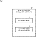
- FIG. 1 is a block diagram showing the schematic configuration of the vegetation index calculation apparatus in the example embodiment of the invention.
- a vegetation index calculation apparatus 10 shown in FIG. 1 is an apparatus for calculating a vegetation index of a target region, such as a specific field or area, for example. As shown in FIG. 1 , the vegetation index calculation apparatus 10 is provided with a specification unit 11 and a vegetation index calculation unit 12.
- the specification unit 11 acquires height distribution data.
- the height distribution data is data indicating the distribution of the height of plants that exists in the target region.
- the height distribution data is data that indicates the distribution of the height of plants in the target region, in a manner such as a region R1 in which the plant height is less than M (unit is omitted), a region R2 in which the plant height is greater than or equal to M and less than N, and a region R3 in which the plant height is greater than or equal to N in the target region, for example.
- the way of deciding the heights when dividing the regions and the number of regions are not particularly limited.
- the heights of the plants within each region can be averaged, and the average height can be taken as the height of the plants in the respective regions.
- a value obtained by averaging envelope curves indicating the heights of the plants can be used as the average height.
- the specification unit 11 collates the height distribution data with predicted height data of the crop targeted for calculation of a vegetation index, and specifies a region where the crop exists within the target region.
- the vegetation index calculation unit 12 calculates a vegetation index of the crop that exists in the region specified by the specification unit 11.
- the specification unit 11 compares height distribution data relating to the actual height distribution of plants in a target region with height data predicted in relation to the height of the crop targeted for calculation of a vegetation index. Therefore, the specification unit 11 is able to specify a region where a crop targeted for calculation of a vegetation index exists in the target region, even when there are plants other than the crop.
- a vegetation index of a targeted crop can be accurately calculated in a specific field or area.
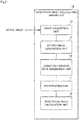
- FIG. 2 is a block diagram showing a specific configuration of the vegetation index calculation apparatus in the example embodiment of the invention.
- FIG. 3 is a diagram illustrating processing performed by the vegetation index calculation apparatus in the example embodiment of the invention.
- the vegetation index calculation apparatus 10 is provided with an image acquisition unit 13, a stereo image generation unit 14 and a height distribution data generation unit 15, in addition to the specification unit 11 and vegetation index calculation unit 12 described above.
- the image acquisition unit 13 acquires an aerial image of the target region.
- the image acquisition unit 13 acquires an aerial image of a field or the like taken from the sky by a satellite, a plane, a drone or the like, for example.
- the stereo image generation unit 14 generates a stereo image of the target region from the aerial image acquired by the image acquisition unit 13.
- the stereo image is an image generated from images obtained by shooting a target region 20 from the sky from different viewpoints, as shown in FIG. 3 .
- the taking of images for generating a stereo image is usually performed by two cameras 21 mounted in parallel in a satellite, a plane, a drone or the like.
- the taking of images for generating a stereo image may be performed by one camera 21 while changing the shooting position.
- generation of a stereo image includes selecting a pair of images to serve as the stereo image from aerial images acquired by the image acquisition unit 13.
- the height distribution data generation unit 15 calculates the heights of plants that exist in the target region 20, by performing stereo matching processing on the stereo image generated by the stereo image generation unit 14. Also, the height distribution data generation unit 15, upon calculating the heights of the plants that exist in the target region 20, generates height distribution data 22 of the plants in the target region 20, as shown in FIG. 3 , using the calculated heights.
- the height distribution data generation unit 15 divides each of the images constituting the stereo image into image blocks of certain size, for example. Next, the height distribution data generation unit 15 selects an arbitrary image block from one of the images constituting the stereo image, compares this selected image block with each image block of the other image constituting the stereo image, and specifies an image block of the other image that matches the selected image block.
- the height distribution data generation unit 15 performs similar processing for all the image blocks of the one image, and specifies the corresponding image block in the other image for each of the image blocks of the one image. Pairs of image blocks of the one image and image blocks of the other image that match each other are thereby created.
- the height distribution data generation unit 15 specifies, for each pair of matching image blocks, a point at which the image blocks correspond to each other as a corresponding point.
- the height distribution data generation unit 15 superimposes the one image and the other image, and calculates the disparity between the specified corresponding points for every pair of matching image blocks.
- the height distribution data generation unit 15 calculates, for every pair of matching image blocks, the height of the corresponding point by executing triangulation, using the calculated disparity and the distance from the image capturing apparatus that took the aerial image to the target region.
- the height of a corresponding point that corresponds to a plant is the height of the plant.
- the specification unit 11 acquires data (height prediction data) 23 predicted in relation to the height of the crop targeted for calculation of a vegetation index, as shown in FIG. 3 .
- the height prediction data 23 may be calculated using any technique.
- a virtual field is generated on a computer, based on field information including at least one of weather information, soil information, crop information, crop growth information and agricultural management history information of a field.
- growth simulation that uses a crop growth model is executed in this virtual field, and the height of the crop under a predetermined condition (e.g., predetermined time) is predicted from the execution result.
- the height in this case may be height of the crop from the ground to the highest point reached, or may be the predicted height indicated by the envelope curve of the crop.
- the specification unit 11 collates the height prediction data 23 with the height distribution data 22 generated by the height distribution data generation unit 15, and specifies a region where the crop exists within the target region 20.
- the height distribution data 22 indicates a region A and a region B where the plants have different heights.
- the height of the crop shown by the height prediction data 23 coincides with the height of the region A.
- the specification unit 11 specifies the region A as a region where the crop targeted for calculation of a vegetation index exists. Note that the height distribution data 22 and the height prediction data 23 are actually numeric data, but are shown conceptually in FIG. 3 .
- the height distribution data 22 matches the height prediction data 23 as a region where the crop exists, it is also possible, if the crop and plants other than the crop can be distinguished, to specify a region where the height distribution data 22 matches the height prediction data 23 with a width of a predetermined numerical value as a region where the crop exists.
- the vegetation index calculation unit 12 calculates a vegetation index of the crop that is being grown in the region specified by the specification unit 11. Specifically, the vegetation index calculation unit 12 receives notification of a region where the crop exists from the specification unit 11, and specifies an image of the region where the crop exists within the aerial image of the target region 20. The vegetation index calculation unit 12 then calculates a vegetation index of the crop from the specified image. Note that the specification unit 11 may specify the image of the region where the crop exists within the aerial image of the target region 20.
- SAVI Soil Adjusted Vegetation Index
- WDVI Weighted Difference Vegetation Index
- NDRE Normalized Difference Red Edge
- SAVI is an index obtained by taking the effects of reflection of the background soil into account in NDVI.
- WDVI is a weighted difference vegetation index, and is calculated by weighting each band of reflected light from a plant with the value of soil taken as 0.
- NDRE is an index obtained by normalizing values measured in a Red Edge band (near a wavelength of 710 nm) by RapidEye satellites.
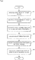
- FIG. 4 is a flowchart showing operations of the vegetation index calculation apparatus in the example embodiment of the invention.
- FIGS. 1 to 3 will be referred to as appropriate.
- a vegetation index calculation method is implemented by operating the vegetation index calculation apparatus 10. Therefore, description of the vegetation index calculation method in the example embodiment will be replaced by the following description of the operations of the vegetation index calculation apparatus 10.
- the image acquisition unit 13 acquires an aerial image of the target region 20 (step A1).
- the stereo image generation unit 14 generates a stereo image of the target region 20 (step A2).
- the stereo image generation unit 14 passes the generated stereo image to the height distribution data generation unit 15.
- the height distribution data generation unit 15 calculates the heights of plants that exist in the target region 20, by performing stereo matching processing on the stereo image generated by the stereo image generation unit 14, and generates height distribution data 22 of the plants in the target region 20, using the calculated heights (step A3).
- the height distribution data generation unit 15 passes the generated height distribution data 22 to the specification unit 11.
- the specification unit 11 acquires data (height prediction data) 23 predicted in relation to the height of the crop targeted for calculation of a vegetation index (step A4).
- the specification unit 11 collates the height prediction data 23 acquired in step A4 with the height distribution data 22 generated by the height distribution data generation unit 15 in step A3, and specifies a region where the crop exists in the target region 20 (step A5).
- the specification unit 11 notifies the specified region to the vegetation index calculation unit 12.
- the vegetation index calculation unit 12 calculates a vegetation index of the crop that is being grown in the region specified by the specification unit 11 in step A5 (step A6). Specifically, the vegetation index calculation unit 12 receives notification of the region where the crop exists from the specification unit 11, and specifies an image of the region specified in step A5 within the aerial image of the target region 20. The vegetation index calculation unit 12 then calculates a vegetation index (e.g., NDVI) of the crop from the specified image.
- a vegetation index e.g., NDVI
- a region where the crop exists is specified based on the height information on plants obtained from an aerial image.
- a vegetation index of a targeted crop can be accurately calculated in a specific field or area.
- the height distribution data generation unit 15 generates the height distribution data 22 from a stereo image, but the example embodiment is not limited to this mode, and the height distribution data generation unit 15 may generate height distribution data by another technique.
- another apparatus can be provided with the stereo image generation unit 14 and the height distribution data generation unit 15, instead of the vegetation index calculation apparatus 10.
- the aerial image acquired by the image acquisition unit 13 of the vegetation index calculation apparatus 10 is transmitted to the apparatus A, and generation of a stereo image and generation of height distribution data are performed in this apparatus A.
- the vegetation index calculation apparatus 10 then acquires the height distribution data from this apparatus A.
- the specification unit 11 compares height distribution data relating to the actual height distribution of plants in the target region with height data predicted in relation to the height of the crop targeted for calculation of a vegetation index.
- the specification unit 11 is also able to compare height distribution data relating to the actual height distribution of the plants in a target region with height data predicted in relation to the height of plants other than the crop, such as weeds, for example, that can exist in the target region, and to specify a region where the weeds exist within the target region.
- the vegetation index calculation unit 12 is able to calculate a vegetation index of weeds that exist in a region specified by the specification unit 11, and correct the vegetation index calculated from the entire aerial image of the target region, using the vegetation index of the weeds. As a result of this correction, a vegetation index of the crop can be accurately calculated.
- the program in the example embodiment need only be a program that causes a computer to execute steps A1 to A6 shown in FIG. 4 .
- the vegetation index calculation apparatus 10 and the vegetation index calculation method in the example embodiment can be realized, by this program being installed on a computer and executed.
- a processor of the computer functions and performs processing as the specification unit 11, the vegetation index calculation unit 12, the image acquisition unit 13, the stereo image generation unit 14 and the height distribution data generation unit 15.
- the program in the example embodiment may be executed by a computer system built with a plurality of computers.
- the computers may respectively function as one of the specification unit 11, the vegetation index calculation unit 12, the image acquisition unit 13, the stereo image generation unit 14 and the height distribution data generation unit 15.
- FIG. 5 is a block diagram showing an example of a computer that realizes the vegetation index calculation apparatus in the example embodiment of the invention.
- a computer 110 is provided with a CPU (Central Processing Unit) 111, a main memory 112, a storage device 113, an input interface 114, a display controller 115, a data reader/writer 116, and a communication interface 117. These units are connected to each other in a manner that enables data communication, via a bus 121.
- the computer 110 may be provided with a GPU (Graphics Processing Unit) or a FPGA (Field-Programmable Gate Array) in addition to the CPU 111 or instead of the CPU 111.
- the CPU 111 implements various computations, by extracting programs (code) of the example embodiment stored in the storage device 113 to the main memory 112, and executing these programs in a predetermined order.
- the main memory 112 is, typically, a volatile storage device such as a DRAM (Dynamic Random Access Memory).
- the programs of the example embodiment can be provided in a state of being stored on a non-transitory computer readable recording medium 120. Note that the programs of the example embodiment may also be distributed on the Internet connected via the communication interface 117.
- the data reader/writer 116 mediates data transmission between the CPU 111 and the recording medium 120, and executes reading out of programs from the recording medium 120, and writing of processing results of the computer 110 to the recording medium 120.
- the communication interface 117 mediates data transmission between the CPU 111 and other computers.
- a general-purpose semiconductor memory such as CF (Compact Flash (registered trademark)) and SD (Secure Digital), a magnetic recording medium such a flexible disk, or an optical recording medium such as CD-ROM (Compact Disk Read Only Memory) are given as specific examples of the recording medium 120.
- CF Compact Flash (registered trademark)
- SD Secure Digital
- CD-ROM Compact Disk Read Only Memory
- the vegetation index calculation apparatus 10 in the example embodiment is also realizable by using hardware that supports the various components, rather than a computer on which programs are installed. Furthermore, the vegetation index calculation apparatus 10 may be partly realized by programs, and the remaining portion may be realized by hardware.
- a vegetation index calculation apparatus including:
- the vegetation index calculation apparatus according to Supplementary Note 1, further including:
- the vegetation index calculation apparatus in which the predicted height data of the crop is generated by performing growth simulation that uses a crop growth model, in a virtual field generated based on field information including at least one of weather information, soil information, crop information, crop growth information and agricultural management history information of a field.
- the vegetation index calculation method further including:
- the vegetation index calculation method in which the predicted height data of the crop is generated by performing growth simulation that uses a crop growth model, in a virtual field generated based on field information including at least one of weather information, soil information, crop information, crop growth information and agricultural management history information of a field.
- a computer readable recording medium that includes a program recorded thereon, the program including instructions that cause a computer to carry out:
- the computer readable recording medium includes instructions that cause the computer to further carry out:
- the computer readable recording medium in which the predicted height data of the crop is generated by performing growth simulation that uses a crop growth model, in a virtual field generated based on field information including at least one of weather information, soil information, crop information, crop growth information and agricultural management history information of a field.
- a vegetation index of a targeted crop can be accurately calculated in a specific field or area.
- the invention is useful in a system that performs prediction of crop yields, which requires accurate vegetation index values.
Landscapes
- Engineering & Computer Science (AREA)
- Physics & Mathematics (AREA)
- General Physics & Mathematics (AREA)
- Theoretical Computer Science (AREA)
- General Health & Medical Sciences (AREA)
- Multimedia (AREA)
- Health & Medical Sciences (AREA)
- Computer Vision & Pattern Recognition (AREA)
- Geometry (AREA)
- Management, Administration, Business Operations System, And Electronic Commerce (AREA)
- Image Processing (AREA)
- Investigating Or Analysing Materials By Optical Means (AREA)
- Image Analysis (AREA)
Abstract
Description
- The present invention relates to a vegetation index calculation apparatus and a vegetation index calculation method that are for calculating a vegetation index of plants, and, furthermore, to a computer readable recording medium for realizing the apparatus and method.
- In recent years, efforts have been made to predict crop yields by computer simulation following advances in computers. For example, Patent Document 1 proposes a system that predicts crop yields by ascertaining the growth condition of crops in a field.
- Specifically, the system disclosed in Patent Document 1, first, calculates a vegetation index of the crop and an effective cumulative temperature, for every period, for a specific field (or area), based on satellite data and meteorological data, and generates a growth curve of the crop up to the present time using the calculated data. Next, the system disclosed in Patent Document 1 generates a statistical model using the obtained growth curve, and predicts a future growth curve using the generated statistical model.
- Also, in such a system, the accuracy of the vegetation index of the crop is important. An example of a known vegetation index is NDVI (Normalized Difference Vegetation Index). NDVI is an index that utilizes the characteristics of plant leaves absorbing blue and red wavelengths and strongly reflecting wavelengths in the near-infrared region, and indicates the distribution and activity of vegetation. The tendency is for vegetation to be thicker as the value of NDVI becomes a larger positive value.
- Patent Document 1: Japanese Patent Laid-Open Publication No.
2015-188333 - Incidentally, NDVI is calculated by normalizing a value obtained by (IR-R)/(IR+R) between -1 and +1, where R is the reflectance of the red visible region obtained from satellite data, and IR is the reflectance of the near-infrared region obtained from satellite data. In other words, NDVI is calculated from data obtained by satellite.
- However, since plants other than the crop, such as weeds, for example, also proliferate in an actual field, NVDI is a value that includes weed vegetation. Thus, the reliability of NDVI may be low, and in such cases, the predictive accuracy of crop yields drops markedly.
- An example object of the invention is to provide a vegetation index calculation apparatus, a vegetation index calculation method and a computer readable recording medium that solve the above problems and can accurately calculate a vegetation index of a targeted crop in a specific field or area.
- A vegetation index calculation apparatus according to an example aspect of the invention includes:
- a specification unit configured to collate height distribution data indicating a distribution of a height of plants that exist in a target region with predicted height data of a crop targeted for calculation of a vegetation index, and specify a region where the crop exists within the target region; and
- a vegetation index calculation unit configured to calculate the vegetation index of the crop that exists in the region specified by the specification unit.
- A vegetation index calculation method according to an example aspect of the invention includes:
- (a) a step of collating height distribution data indicating a distribution of a height of plants that exist in a target region with predicted height data of a crop targeted for calculation of a vegetation index, and specifying a region where the crop exists within the target region; and
- (b) a step of calculating the vegetation index of the crop that exists in the region specified in the (a) step.
- Furthermore, a computer readable recording medium according to an example aspect of the invention includes a program recorded thereon, the program including instructions that cause a computer to carry out:
- (a) a step of collating height distribution data indicating a distribution of a height of plants that exist in a target region with predicted height data of a crop targeted for calculation of a vegetation index, and specifying a region where the crop exists within the target region; and
- (b) a step of calculating the vegetation index of the crop that exists in the region specified in the (a) step.
- As described above, according to the invention, a vegetation index of a targeted crop can be accurately calculated in a specific field or area.
-
-
FIG. 1 is a block diagram showing a schematic configuration of a vegetation index calculation apparatus in an example embodiment of the invention. -
FIG. 2 is a block diagram showing a specific configuration of the vegetation index calculation apparatus in the example embodiment of the invention. -
FIG. 3 is an illustrative diagram illustrating processing that is performed by the vegetation index calculation apparatus in the example embodiment of the invention. -
FIG. 4 is a flowchart showing operations of the vegetation index calculation apparatus in the example embodiment of the invention. -
FIG. 5 is a block diagram showing an example of a computer that realizes the vegetation index calculation apparatus in the example embodiment of the invention. - Hereinafter, a vegetation index calculation apparatus, a vegetation index calculation method and a program in an example embodiment of the invention will be described, with reference to
FIGS. 1 to 5 . - Initially, a schematic configuration of the vegetation index calculation apparatus in the example embodiment will be described, using
FIG. 1. FIG. 1 is a block diagram showing the schematic configuration of the vegetation index calculation apparatus in the example embodiment of the invention. - A vegetation
index calculation apparatus 10 shown inFIG. 1 is an apparatus for calculating a vegetation index of a target region, such as a specific field or area, for example. As shown inFIG. 1 , the vegetationindex calculation apparatus 10 is provided with aspecification unit 11 and a vegetationindex calculation unit 12. - The
specification unit 11, first, acquires height distribution data. The height distribution data is data indicating the distribution of the height of plants that exists in the target region. The height distribution data is data that indicates the distribution of the height of plants in the target region, in a manner such as a region R1 in which the plant height is less than M (unit is omitted), a region R2 in which the plant height is greater than or equal to M and less than N, and a region R3 in which the plant height is greater than or equal to N in the target region, for example. The way of deciding the heights when dividing the regions and the number of regions are not particularly limited. Also, for example, the heights of the plants within each region can be averaged, and the average height can be taken as the height of the plants in the respective regions. Specifically, a value obtained by averaging envelope curves indicating the heights of the plants can be used as the average height. - Next, the
specification unit 11 collates the height distribution data with predicted height data of the crop targeted for calculation of a vegetation index, and specifies a region where the crop exists within the target region. - The vegetation
index calculation unit 12 calculates a vegetation index of the crop that exists in the region specified by thespecification unit 11. - In this way, in the example embodiment, the
specification unit 11 compares height distribution data relating to the actual height distribution of plants in a target region with height data predicted in relation to the height of the crop targeted for calculation of a vegetation index. Therefore, thespecification unit 11 is able to specify a region where a crop targeted for calculation of a vegetation index exists in the target region, even when there are plants other than the crop. Thus, according to the example embodiment, a vegetation index of a targeted crop can be accurately calculated in a specific field or area. - Next, a specific configuration of the vegetation
index calculation apparatus 10 in the example embodiment will be described, usingFIGS. 2 and3 .FIG. 2 is a block diagram showing a specific configuration of the vegetation index calculation apparatus in the example embodiment of the invention.FIG. 3 is a diagram illustrating processing performed by the vegetation index calculation apparatus in the example embodiment of the invention. - As shown in
FIG. 2 , in the example embodiment, the vegetationindex calculation apparatus 10 is provided with animage acquisition unit 13, a stereoimage generation unit 14 and a height distributiondata generation unit 15, in addition to thespecification unit 11 and vegetationindex calculation unit 12 described above. - The
image acquisition unit 13 acquires an aerial image of the target region. Theimage acquisition unit 13 acquires an aerial image of a field or the like taken from the sky by a satellite, a plane, a drone or the like, for example. - The stereo
image generation unit 14 generates a stereo image of the target region from the aerial image acquired by theimage acquisition unit 13. The stereo image is an image generated from images obtained by shooting atarget region 20 from the sky from different viewpoints, as shown inFIG. 3 . The taking of images for generating a stereo image is usually performed by twocameras 21 mounted in parallel in a satellite, a plane, a drone or the like. The taking of images for generating a stereo image may be performed by onecamera 21 while changing the shooting position. Note that generation of a stereo image includes selecting a pair of images to serve as the stereo image from aerial images acquired by theimage acquisition unit 13. - The height distribution
data generation unit 15 calculates the heights of plants that exist in thetarget region 20, by performing stereo matching processing on the stereo image generated by the stereoimage generation unit 14. Also, the height distributiondata generation unit 15, upon calculating the heights of the plants that exist in thetarget region 20, generatesheight distribution data 22 of the plants in thetarget region 20, as shown inFIG. 3 , using the calculated heights. - Specifically, the height distribution
data generation unit 15 divides each of the images constituting the stereo image into image blocks of certain size, for example. Next, the height distributiondata generation unit 15 selects an arbitrary image block from one of the images constituting the stereo image, compares this selected image block with each image block of the other image constituting the stereo image, and specifies an image block of the other image that matches the selected image block. - Also, the height distribution
data generation unit 15 performs similar processing for all the image blocks of the one image, and specifies the corresponding image block in the other image for each of the image blocks of the one image. Pairs of image blocks of the one image and image blocks of the other image that match each other are thereby created. - Next, the height distribution
data generation unit 15 specifies, for each pair of matching image blocks, a point at which the image blocks correspond to each other as a corresponding point. Next, the height distributiondata generation unit 15 superimposes the one image and the other image, and calculates the disparity between the specified corresponding points for every pair of matching image blocks. Thereafter, the height distributiondata generation unit 15 calculates, for every pair of matching image blocks, the height of the corresponding point by executing triangulation, using the calculated disparity and the distance from the image capturing apparatus that took the aerial image to the target region. The height of a corresponding point that corresponds to a plant is the height of the plant. - The
specification unit 11, in the example embodiment, acquires data (height prediction data) 23 predicted in relation to the height of the crop targeted for calculation of a vegetation index, as shown inFIG. 3 . Theheight prediction data 23 may be calculated using any technique. - For example, first, a virtual field is generated on a computer, based on field information including at least one of weather information, soil information, crop information, crop growth information and agricultural management history information of a field. Next, in this virtual field, growth simulation that uses a crop growth model is executed in this virtual field, and the height of the crop under a predetermined condition (e.g., predetermined time) is predicted from the execution result. Note that the height in this case may be height of the crop from the ground to the highest point reached, or may be the predicted height indicated by the envelope curve of the crop.
- Next, the
specification unit 11 collates theheight prediction data 23 with theheight distribution data 22 generated by the height distributiondata generation unit 15, and specifies a region where the crop exists within thetarget region 20. - In the example in
FIG. 3 , theheight distribution data 22 indicates a region A and a region B where the plants have different heights. The height of the crop shown by theheight prediction data 23 coincides with the height of the region A. Thus, thespecification unit 11 specifies the region A as a region where the crop targeted for calculation of a vegetation index exists. Note that theheight distribution data 22 and theheight prediction data 23 are actually numeric data, but are shown conceptually inFIG. 3 . - Also, apart from specifying a region where the
height distribution data 22 matches theheight prediction data 23 as a region where the crop exists, it is also possible, if the crop and plants other than the crop can be distinguished, to specify a region where theheight distribution data 22 matches theheight prediction data 23 with a width of a predetermined numerical value as a region where the crop exists. - The vegetation
index calculation unit 12 calculates a vegetation index of the crop that is being grown in the region specified by thespecification unit 11. Specifically, the vegetationindex calculation unit 12 receives notification of a region where the crop exists from thespecification unit 11, and specifies an image of the region where the crop exists within the aerial image of thetarget region 20. The vegetationindex calculation unit 12 then calculates a vegetation index of the crop from the specified image. Note that thespecification unit 11 may specify the image of the region where the crop exists within the aerial image of thetarget region 20. - SAVI (Soil Adjusted Vegetation Index), WDVI (Weighted Difference Vegetation Index, and NDRE (Normalized Difference Red Edge) are given as examples of the vegetation index that is calculated in the example embodiment, in addition to NDVI mentioned in the Background Art.
- SAVI is an index obtained by taking the effects of reflection of the background soil into account in NDVI. WDVI is a weighted difference vegetation index, and is calculated by weighting each band of reflected light from a plant with the value of soil taken as 0. NDRE is an index obtained by normalizing values measured in a Red Edge band (near a wavelength of 710 nm) by RapidEye satellites.
- Next, operations of the vegetation
index calculation apparatus 10 in the example embodiment will be described usingFIG. 4. FIG. 4 is a flowchart showing operations of the vegetation index calculation apparatus in the example embodiment of the invention. In the following description,FIGS. 1 to 3 will be referred to as appropriate. Also, in the example embodiment, a vegetation index calculation method is implemented by operating the vegetationindex calculation apparatus 10. Therefore, description of the vegetation index calculation method in the example embodiment will be replaced by the following description of the operations of the vegetationindex calculation apparatus 10. - As shown in
FIG. 4 , initially, theimage acquisition unit 13 acquires an aerial image of the target region 20 (step A1). Next, the stereoimage generation unit 14 generates a stereo image of the target region 20 (step A2). The stereoimage generation unit 14 passes the generated stereo image to the height distributiondata generation unit 15. - Next, the height distribution
data generation unit 15 calculates the heights of plants that exist in thetarget region 20, by performing stereo matching processing on the stereo image generated by the stereoimage generation unit 14, and generatesheight distribution data 22 of the plants in thetarget region 20, using the calculated heights (step A3). The height distributiondata generation unit 15 passes the generatedheight distribution data 22 to thespecification unit 11. - Next, the
specification unit 11 acquires data (height prediction data) 23 predicted in relation to the height of the crop targeted for calculation of a vegetation index (step A4). - Next, the
specification unit 11 collates theheight prediction data 23 acquired in step A4 with theheight distribution data 22 generated by the height distributiondata generation unit 15 in step A3, and specifies a region where the crop exists in the target region 20 (step A5). Thespecification unit 11 notifies the specified region to the vegetationindex calculation unit 12. - Next, the vegetation
index calculation unit 12 calculates a vegetation index of the crop that is being grown in the region specified by thespecification unit 11 in step A5 (step A6). Specifically, the vegetationindex calculation unit 12 receives notification of the region where the crop exists from thespecification unit 11, and specifies an image of the region specified in step A5 within the aerial image of thetarget region 20. The vegetationindex calculation unit 12 then calculates a vegetation index (e.g., NDVI) of the crop from the specified image. - As described above, according to the example embodiment, a region where the crop exists is specified based on the height information on plants obtained from an aerial image. Thus, according to the example embodiment, a vegetation index of a targeted crop can be accurately calculated in a specific field or area.
- Also, in steps A1 to A6 mentioned above, the height distribution
data generation unit 15 generates theheight distribution data 22 from a stereo image, but the example embodiment is not limited to this mode, and the height distributiondata generation unit 15 may generate height distribution data by another technique. - Also, another apparatus (apparatus A) can be provided with the stereo
image generation unit 14 and the height distributiondata generation unit 15, instead of the vegetationindex calculation apparatus 10. In this case, the aerial image acquired by theimage acquisition unit 13 of the vegetationindex calculation apparatus 10 is transmitted to the apparatus A, and generation of a stereo image and generation of height distribution data are performed in this apparatus A. The vegetationindex calculation apparatus 10 then acquires the height distribution data from this apparatus A. - In the above description, a mode where the
specification unit 11 compares height distribution data relating to the actual height distribution of plants in the target region with height data predicted in relation to the height of the crop targeted for calculation of a vegetation index is described. Apart from this mode, thespecification unit 11 is also able to compare height distribution data relating to the actual height distribution of the plants in a target region with height data predicted in relation to the height of plants other than the crop, such as weeds, for example, that can exist in the target region, and to specify a region where the weeds exist within the target region. In this case, the vegetationindex calculation unit 12 is able to calculate a vegetation index of weeds that exist in a region specified by thespecification unit 11, and correct the vegetation index calculated from the entire aerial image of the target region, using the vegetation index of the weeds. As a result of this correction, a vegetation index of the crop can be accurately calculated. - The program in the example embodiment need only be a program that causes a computer to execute steps A1 to A6 shown in
FIG. 4 . The vegetationindex calculation apparatus 10 and the vegetation index calculation method in the example embodiment can be realized, by this program being installed on a computer and executed. In this case, a processor of the computer functions and performs processing as thespecification unit 11, the vegetationindex calculation unit 12, theimage acquisition unit 13, the stereoimage generation unit 14 and the height distributiondata generation unit 15. - Also, the program in the example embodiment may be executed by a computer system built with a plurality of computers. In this case, for example, the computers may respectively function as one of the
specification unit 11, the vegetationindex calculation unit 12, theimage acquisition unit 13, the stereoimage generation unit 14 and the height distributiondata generation unit 15. - Here, a computer that realizes the vegetation
index calculation apparatus 10 by executing a program in the example embodiment will be described usingFIG. 5. FIG. 5 is a block diagram showing an example of a computer that realizes the vegetation index calculation apparatus in the example embodiment of the invention. - As shown in
FIG. 5 , acomputer 110 is provided with a CPU (Central Processing Unit) 111, amain memory 112, astorage device 113, aninput interface 114, adisplay controller 115, a data reader/writer 116, and acommunication interface 117. These units are connected to each other in a manner that enables data communication, via abus 121. Note that thecomputer 110 may be provided with a GPU (Graphics Processing Unit) or a FPGA (Field-Programmable Gate Array) in addition to theCPU 111 or instead of theCPU 111. - The
CPU 111 implements various computations, by extracting programs (code) of the example embodiment stored in thestorage device 113 to themain memory 112, and executing these programs in a predetermined order. Themain memory 112 is, typically, a volatile storage device such as a DRAM (Dynamic Random Access Memory). Also, the programs of the example embodiment can be provided in a state of being stored on a non-transitory computerreadable recording medium 120. Note that the programs of the example embodiment may also be distributed on the Internet connected via thecommunication interface 117. - Also, a semiconductor memory device such as a flash memory is given as a specific example of the
storage device 113, in addition to a hard disk drive. Theinput interface 114 mediates data transmission between theCPU 111 and aninput device 118 such a keyboard and a mouse. Thedisplay controller 115 is connected to adisplay device 119, and controls display that is performed on thedisplay device 119. - The data reader/
writer 116 mediates data transmission between theCPU 111 and therecording medium 120, and executes reading out of programs from therecording medium 120, and writing of processing results of thecomputer 110 to therecording medium 120. Thecommunication interface 117 mediates data transmission between theCPU 111 and other computers. - Also, a general-purpose semiconductor memory such as CF (Compact Flash (registered trademark)) and SD (Secure Digital), a magnetic recording medium such a flexible disk, or an optical recording medium such as CD-ROM (Compact Disk Read Only Memory) are given as specific examples of the
recording medium 120. - Note that the vegetation
index calculation apparatus 10 in the example embodiment is also realizable by using hardware that supports the various components, rather than a computer on which programs are installed. Furthermore, the vegetationindex calculation apparatus 10 may be partly realized by programs, and the remaining portion may be realized by hardware. - The above example embodiment can also be partly or wholly represented by Supplementary Notes 1 to 9 described below, but is not limited to the following disclosure.
- A vegetation index calculation apparatus including:
- a specification unit configured to collate height distribution data indicating a distribution of a height of plants that exist in a target region with predicted height data of a crop targeted for calculation of a vegetation index, and specify a region where the crop exists within the target region; and
- a vegetation index calculation unit configured to calculate the vegetation index of the crop that exists in the region specified by the specification unit.
- The vegetation index calculation apparatus according to Supplementary Note 1, further including:
- an image acquisition unit configured to acquire an aerial image of the target region;
- a stereo image generation unit configured to generate a stereo image from the aerial image acquired by the image acquisition unit; and
- a height distribution data generation unit configured to calculate the heights of plants that exist in the target region, by performing stereo matching processing on the stereo image generated by the stereo image generation unit, and generate the height distribution data using the calculated heights, and
- in which the vegetation index calculation unit calculates the vegetation index of the crop, using an image of the region specified by the specification unit within the aerial image.
- The vegetation index calculation apparatus according to Supplementary Note 1 or 2, in which the predicted height data of the crop is generated by performing growth simulation that uses a crop growth model, in a virtual field generated based on field information including at least one of weather information, soil information, crop information, crop growth information and agricultural management history information of a field.
- A vegetation index calculation method including:
- (a) a step of collating height distribution data indicating a distribution of a height of plants that exist in a target region with predicted height data of a crop targeted for calculation of a vegetation index, and specifying a region where the crop exists within the target region; and
- (b) a step of calculating the vegetation index of the crop that exists in the region specified in the (a) step.
- The vegetation index calculation method according to Supplementary Not e 4, further including:
- (c) a step of acquiring an aerial image of the target region;
- (d) a step of generating a stereo image from the aerial image acquired in the (c) step; and
- (e) a step of calculating the heights of the plants that exist in the target region, by performing stereo matching processing on the stereo image generated in the (d) step, and generating the height distribution data using the calculated heights,
- The vegetation index calculation method according to Supplementary Note 4 or 5, in which the predicted height data of the crop is generated by performing growth simulation that uses a crop growth model, in a virtual field generated based on field information including at least one of weather information, soil information, crop information, crop growth information and agricultural management history information of a field.
- A computer readable recording medium that includes a program recorded thereon, the program including instructions that cause a computer to carry out:
- (a) a step of collating height distribution data indicating a distribution of a height of plants that exist in a target region with predicted height data of a crop targeted for calculation of a vegetation index, and specifying a region where the crop exists within the target region; and
- (b) a step of calculating the vegetation index of the crop that exists in the region specified in the (a) step.
- The computer readable recording medium according to Supplementary Note 7, the program includes instructions that cause the computer to further carry out:
- (c) a step of acquiring an aerial image of the target region;
- (d) a step of generating a stereo image from the aerial image acquired in the (c) step; and
- (e) a step of calculating the heights of the plants that exist in the target region, by performing stereo matching processing on the stereo image generated in the (d) step, and generating the height distribution data using the calculated heights,
- The computer readable recording medium according to Supplementary Note 7 or 8, in which the predicted height data of the crop is generated by performing growth simulation that uses a crop growth model, in a virtual field generated based on field information including at least one of weather information, soil information, crop information, crop growth information and agricultural management history information of a field.
- Although the invention has been described above with reference to an example embodiment, the invention is not intended to be limited to the above example embodiment. A person skilled in the art will appreciate that the configurations and details of the invention can be variously modified within the scope of the invention.
- This application is based upon and claims the benefit of priority from Japanese application No.
2017-57782 - As described above, according to the invention, a vegetation index of a targeted crop can be accurately calculated in a specific field or area. The invention is useful in a system that performs prediction of crop yields, which requires accurate vegetation index values.
-
- 10
- Vegetation index calculation apparatus
- 11
- Specification unit
- 12
- Vegetation index calculation unit
- 14
- Stereo image generation unit
- 15
- Height distribution data generation unit
- 20
- Target region
- 21
- Camera
- 22
- Height distribution data
- 23
- Height prediction data
- 110
- Computer
- 111
- CPU
- 112
- Main memory
- 113
- Storage device
- 114
- Input interface
- 115
- Display controller
- 116
- Data reader/writer
- 117
- Communication interface
- 118
- Input device
- 119
- Display device
- 120
- Recording medium
- 121
- Bus
Claims (9)
- A vegetation index calculation apparatus comprising:a specification unit configured to collate height distribution data indicating a distribution of a height of plants that exist in a target region with predicted height data of a crop targeted for calculation of a vegetation index, and specify a region where the crop exists within the target region; anda vegetation index calculation unit configured to calculate the vegetation index of the crop that exists in the region specified by the specification unit.
- The vegetation index calculation apparatus according to claim 1, further comprising:an image acquisition unit configured to acquire an aerial image of the target region;a stereo image generation unit configured to generate a stereo image from the aerial image acquired by the image acquisition unit; anda height distribution data generation unit configured to calculate the heights of plants that exist in the target region, by performing stereo matching processing on the stereo image generated by the stereo image generation unit, and generate the height distribution data using the calculated heights,wherein the vegetation index calculation unit calculates the vegetation index of the crop, using an image of the region specified by the specification unit within the aerial image.
- The vegetation index calculation apparatus according to claim 1 or 2,
wherein the predicted height data of the crop is generated by performing growth simulation that uses a crop growth model, in a virtual field generated based on field information including at least one of weather information, soil information, crop information, crop growth information and agricultural management history information of a field. - A vegetation index calculation method comprising:(a) a step of collating height distribution data indicating a distribution of a height of plants that exist in a target region with predicted height data of a crop targeted for calculation of a vegetation index, and specifying a region where the crop exists within the target region; and(b) a step of calculating the vegetation index of the crop that exists in the region specified in the (a) step.
- The vegetation index calculation method according to claim 4, further comprising:(c) a step of acquiring an aerial image of the target region;(d) a step of generating a stereo image from the aerial image acquired in the (c) step; and(e) a step of calculating the heights of the plants that exist in the target region, by performing stereo matching processing on the stereo image generated in the (d) step, and generating the height distribution data using the calculated heights,wherein, in the (b) step, the vegetation index of the crop is calculated, using an image of the region specified in the (a) step within the aerial image.
- The vegetation index calculation method according to claim 4 or 5,
wherein the predicted height data of the crop is generated by performing growth simulation that uses a crop growth model, in a virtual field generated based on field information including at least one of weather information, soil information, crop information, crop growth information and agricultural management history information of a field. - A computer readable recording medium that includes a program recorded thereon, the program including instructions that cause a computer to carry out:(a) a step of collating height distribution data indicating a distribution of a height of plants that exist in a target region with predicted height data of a crop targeted for calculation of a vegetation index, and specifying a region where the crop exists within the target region; and(b) a step of calculating the vegetation index of the crop that exists in the region specified in the (a) step.
- The computer readable recording medium according to claim 7,
wherein the program includes instructions that cause the computer to further carry out:(c) a step of acquiring an aerial image of the target region;(d) a step of generating a stereo image from the aerial image acquired in the (c) step; and(e) a step of calculating the heights of the plants that exist in the target region, by performing stereo matching processing on the stereo image generated in the (d) step, and generating the height distribution data using the calculated heights,wherein, in the (b) step, the vegetation index of the crop is calculated, using an image of the region specified in the (a) step within the aerial image. - The computer readable recording medium according to claim 7 or 8,
wherein the predicted height data of the crop is generated by performing growth simulation that uses a crop growth model, in a virtual field generated based on field information including at least one of weather information, soil information, crop information, crop growth information and agricultural management history information of a field.
Applications Claiming Priority (2)
| Application Number | Priority Date | Filing Date | Title |
|---|---|---|---|
| JP2017057782 | 2017-03-23 | ||
| PCT/JP2018/006583 WO2018173622A1 (en) | 2017-03-23 | 2018-02-22 | Vegetation index calculation device, vegetation index calculation method, and computer readable recording medium |
Publications (3)
| Publication Number | Publication Date |
|---|---|
| EP3605063A1 true EP3605063A1 (en) | 2020-02-05 |
| EP3605063A4 EP3605063A4 (en) | 2020-04-22 |
| EP3605063B1 EP3605063B1 (en) | 2023-04-05 |
Family
ID=63585403
Family Applications (1)
| Application Number | Title | Priority Date | Filing Date |
|---|---|---|---|
| EP18771275.7A Active EP3605063B1 (en) | 2017-03-23 | 2018-02-22 | Vegetation index calculation device and method, and computer program |
Country Status (6)
| Country | Link |
|---|---|
| US (1) | US11348272B2 (en) |
| EP (1) | EP3605063B1 (en) |
| JP (1) | JP6729791B2 (en) |
| ES (1) | ES2945141T3 (en) |
| PT (1) | PT3605063T (en) |
| WO (1) | WO2018173622A1 (en) |
Families Citing this family (13)
| Publication number | Priority date | Publication date | Assignee | Title |
|---|---|---|---|---|
| CN109636171B (en) * | 2018-12-06 | 2022-11-29 | 西安理工大学 | Comprehensive diagnosis and risk evaluation method for regional vegetation recovery |
| US11270112B2 (en) * | 2019-04-16 | 2022-03-08 | Precision Silver, LLC | Systems and methods for rating vegetation health and biomass from remotely sensed morphological and radiometric data |
| JP7288632B2 (en) * | 2019-08-06 | 2023-06-08 | ヤンマーパワーテクノロジー株式会社 | Growth value calculation method and growth value calculation system |
| US11113525B1 (en) * | 2020-05-18 | 2021-09-07 | X Development Llc | Using empirical evidence to generate synthetic training data for plant detection |
| US11398028B2 (en) | 2020-06-08 | 2022-07-26 | X Development Llc | Generating and using synthetic training data for plant disease detection |
| JP2022066907A (en) * | 2020-10-19 | 2022-05-02 | 国立研究開発法人農業・食品産業技術総合研究機構 | Information processing device, information processing method, control program and recording medium |
| CN112347659A (en) * | 2020-11-23 | 2021-02-09 | 河南大学 | Water and soil conservation regulation and control method for river bank buffer zone based on optimal vegetation pattern |
| CN112700347B (en) * | 2020-12-31 | 2024-11-15 | 广州极飞科技股份有限公司 | Method, device and storage medium for generating crop height growth curve |
| US12001512B2 (en) | 2021-05-25 | 2024-06-04 | Mineral Earth Sciences Llc | Generating labeled synthetic training data |
| CN115688955A (en) * | 2021-07-23 | 2023-02-03 | 久瓴(上海)智能科技有限公司 | Vegetation growth prediction method, device and storage medium |
| CN114724029A (en) * | 2022-04-02 | 2022-07-08 | 中科海慧(天津)科技有限公司 | Remote sensing extraction method and system of mining goaf's influence on the surface |
| CN115830442B (en) * | 2022-11-11 | 2023-08-04 | 中国科学院空天信息创新研究院 | A remote sensing method and system for estimating wheat stem and tiller density based on machine learning |
| CN116665081B (en) * | 2023-07-31 | 2023-10-13 | 自然资源部第一海洋研究所 | Coastal vegetation aboveground biomass estimation method, computer equipment and medium |
Family Cites Families (24)
| Publication number | Priority date | Publication date | Assignee | Title |
|---|---|---|---|---|
| JP2004012233A (en) * | 2002-06-05 | 2004-01-15 | Fuji Heavy Ind Ltd | Crop detection device and crop detection method |
| US8737720B2 (en) | 2003-04-30 | 2014-05-27 | Deere & Company | System and method for detecting and analyzing features in an agricultural field |
| JP4553826B2 (en) * | 2005-02-09 | 2010-09-29 | アジア航測株式会社 | Feature environment status providing method and program thereof |
| US7822266B2 (en) | 2006-06-02 | 2010-10-26 | Carnegie Mellon University | System and method for generating a terrain model for autonomous navigation in vegetation |
| WO2010129168A2 (en) * | 2009-05-08 | 2010-11-11 | Pioneer Hi-Bred International, Inc. | Real-time process for targeting trait phenotyping of plant breeding experiments |
| JP5589524B2 (en) * | 2010-04-19 | 2014-09-17 | 株式会社大林組 | Turf growth prediction system and prediction method |
| US8775119B2 (en) | 2011-03-30 | 2014-07-08 | Weyerhaeuser Nr Company | System and method for forest management using stand development performance as measured by LAI |
| JP5305485B2 (en) * | 2011-05-23 | 2013-10-02 | Necシステムテクノロジー株式会社 | Ground height data generating apparatus, ground height data generating method, and program |
| BR102012030671A2 (en) * | 2011-11-30 | 2015-10-20 | Dow Agrosciences Llc | three-dimensional animation technology to describe and manipulate plant growth |
| WO2015092800A1 (en) * | 2013-12-19 | 2015-06-25 | Phytech Ltd. | Method and system for treating crop according to predicted yield |
| JP2015188333A (en) | 2014-03-27 | 2015-11-02 | 株式会社日立製作所 | Vegetation growth analysis system and method |
| JP2016049102A (en) * | 2014-08-29 | 2016-04-11 | 株式会社リコー | Field management system, field management method, program |
| WO2017004074A1 (en) * | 2015-06-30 | 2017-01-05 | Precision Planting Llc | Systems and methods for image capture and analysis of agricultural fields |
| JP6569942B2 (en) | 2015-09-16 | 2019-09-04 | いすゞ自動車株式会社 | Power steering device pump mounting structure |
| WO2017164097A1 (en) * | 2016-03-25 | 2017-09-28 | 日本電気株式会社 | Information processing device, control method for information processing device, and recording medium having control program for information processing device recorded therein |
| US11080361B2 (en) * | 2016-08-05 | 2021-08-03 | Regents Of The University Of Minnesota | Integrated remote sensing tools for timely predictions of crop quality and yield |
| WO2018131480A1 (en) * | 2017-01-10 | 2018-07-19 | 日本電気株式会社 | Information processing device, information processing method, and recording medium on which information processing program is recorded |
| US10909367B2 (en) * | 2017-03-02 | 2021-02-02 | Basecamp Networks, LLC | Automated diagnosis and treatment of crop infestations |
| US11417089B2 (en) * | 2017-03-23 | 2022-08-16 | Nec Corporation | Vegetation index calculation apparatus, vegetation index calculation method, and computer readable recording medium |
| US9984455B1 (en) * | 2017-06-05 | 2018-05-29 | Hana Resources, Inc. | Organism growth prediction system using drone-captured images |
| US20200166496A1 (en) * | 2017-06-29 | 2020-05-28 | Nec Corporation | Coefficient calculation device, coefficient calculation method, and non-transitory recording medium |
| JP6544453B1 (en) * | 2018-03-16 | 2019-07-17 | 日本電気株式会社 | Cultivated crop selection support device, cultivated crop selection support method, and program |
| US10891482B2 (en) * | 2018-07-10 | 2021-01-12 | Adroit Robotics | Systems, devices, and methods for in-field diagnosis of growth stage and crop yield estimation in a plant area |
| US11076589B1 (en) * | 2020-10-16 | 2021-08-03 | Verdant Robotics, Inc. | Autonomous agricultural treatment system using map based targeting of agricultural objects |
-
2018
- 2018-02-22 JP JP2019507468A patent/JP6729791B2/en active Active
- 2018-02-22 ES ES18771275T patent/ES2945141T3/en active Active
- 2018-02-22 EP EP18771275.7A patent/EP3605063B1/en active Active
- 2018-02-22 PT PT187712757T patent/PT3605063T/en unknown
- 2018-02-22 WO PCT/JP2018/006583 patent/WO2018173622A1/en not_active Ceased
- 2018-02-22 US US16/496,229 patent/US11348272B2/en active Active
Also Published As
| Publication number | Publication date |
|---|---|
| ES2945141T3 (en) | 2023-06-28 |
| EP3605063A4 (en) | 2020-04-22 |
| JP6729791B2 (en) | 2020-07-22 |
| US20200058132A1 (en) | 2020-02-20 |
| US11348272B2 (en) | 2022-05-31 |
| JPWO2018173622A1 (en) | 2020-05-14 |
| WO2018173622A1 (en) | 2018-09-27 |
| PT3605063T (en) | 2023-06-02 |
| EP3605063B1 (en) | 2023-04-05 |
Similar Documents
| Publication | Publication Date | Title |
|---|---|---|
| EP3605063B1 (en) | Vegetation index calculation device and method, and computer program | |
| US11417089B2 (en) | Vegetation index calculation apparatus, vegetation index calculation method, and computer readable recording medium | |
| EP4348566B1 (en) | Enhancing generative adversarial networks using combined inputs | |
| Coops et al. | Framework for near real-time forest inventory using multi source remote sensing data | |
| AU2020219867A1 (en) | Shadow and cloud masking for agriculture applications using convolutional neural networks | |
| EP3605435A1 (en) | Field management device, field management method and computer-readable recording medium | |
| WO2014093234A2 (en) | Probabilistic carbon credits calculator | |
| JP7028336B2 (en) | Learning equipment, learning methods and learning programs | |
| JP2018005467A (en) | Farmwork plan support device and farmwork plan support method | |
| AU2015258202B2 (en) | Image generation system and image generation method | |
| Ruiz et al. | Iterative K–Nearest Neighbors Algorithm (IKNN) for submeter spatial resolution image classification obtained by Unmanned Aerial Vehicle (UAV) | |
| CN121453065A (en) | Unmanned aerial vehicle image-based farmland obstacle recognition and operation path planning method | |
| Denisova et al. | Tree species classification for clarification of forest inventory data using Sentinel-2 images | |
| Murata et al. | Three-dimensional leaf edge reconstruction combining two-and three-dimensional approaches | |
| Sitokonstantinou et al. | A Sentinel based agriculture monitoring scheme for the control of the CAP and food security | |
| Müller et al. | Support vector machine classification of woody patches in New Zealand from synthetic aperture radar and optical data, with LiDAR training | |
| US20230410275A1 (en) | Data acquisition apparatus, data acquisition method, and non-transitory computer-readable medium | |
| CN111832472B (en) | Laser point cloud surface point extraction method, device, storage medium and electronic equipment | |
| JP6362839B2 (en) | Material subtraction in scenes based on hyperspectral characteristics | |
| Chaudhari et al. | Discrimination of multi-crop scenarios with polarimetric SAR data using Wishart mixture model | |
| Kleijkers et al. | Deep learning with CNNs for classifying damage type in wheat and grasslands | |
| Demirel et al. | A Multistage Approach for Forest Stand Map Generation Based on Satellite Image and LiDAR Data Fusion | |
| Ceballos Arroyo | A machine learning methodology for land use/land cover classification in tropical areas using medium resolution satellite imagery, case: Colombia | |
| CN121958821A (en) | Ground feature assessment methods and apparatus, readable storage media and electronic devices | |
| BR112021015232A2 (en) | SHADOW AND CLOUD MASKING FOR REMOTE SENSING IMAGES IN AGRICULTURE APPLICATIONS USING MULTI-LAYER PERCEPTRON |
Legal Events
| Date | Code | Title | Description |
|---|---|---|---|
| STAA | Information on the status of an ep patent application or granted ep patent |
Free format text: STATUS: THE INTERNATIONAL PUBLICATION HAS BEEN MADE |
|
| PUAI | Public reference made under article 153(3) epc to a published international application that has entered the european phase |
Free format text: ORIGINAL CODE: 0009012 |
|
| STAA | Information on the status of an ep patent application or granted ep patent |
Free format text: STATUS: REQUEST FOR EXAMINATION WAS MADE |
|
| 17P | Request for examination filed |
Effective date: 20191023 |
|
| AK | Designated contracting states |
Kind code of ref document: A1 Designated state(s): AL AT BE BG CH CY CZ DE DK EE ES FI FR GB GR HR HU IE IS IT LI LT LU LV MC MK MT NL NO PL PT RO RS SE SI SK SM TR |
|
| AX | Request for extension of the european patent |
Extension state: BA ME |
|
| A4 | Supplementary search report drawn up and despatched |
Effective date: 20200320 |
|
| RIC1 | Information provided on ipc code assigned before grant |
Ipc: G01N 21/27 20060101AFI20200316BHEP Ipc: G06T 7/00 20170101ALI20200316BHEP Ipc: A01G 7/00 20060101ALI20200316BHEP Ipc: G06T 7/593 20170101ALI20200316BHEP |
|
| DAV | Request for validation of the european patent (deleted) | ||
| DAX | Request for extension of the european patent (deleted) | ||
| STAA | Information on the status of an ep patent application or granted ep patent |
Free format text: STATUS: EXAMINATION IS IN PROGRESS |
|
| 17Q | First examination report despatched |
Effective date: 20220610 |
|
| RIC1 | Information provided on ipc code assigned before grant |
Ipc: G01N 33/00 20060101ALI20220824BHEP Ipc: G06V 20/10 20220101ALI20220824BHEP Ipc: G06T 7/593 20170101ALI20220824BHEP Ipc: G06T 7/00 20170101ALI20220824BHEP Ipc: A01G 7/00 20060101ALI20220824BHEP Ipc: G01N 21/27 20060101AFI20220824BHEP |
|
| GRAP | Despatch of communication of intention to grant a patent |
Free format text: ORIGINAL CODE: EPIDOSNIGR1 |
|
| STAA | Information on the status of an ep patent application or granted ep patent |
Free format text: STATUS: GRANT OF PATENT IS INTENDED |
|
| INTG | Intention to grant announced |
Effective date: 20221118 |
|
| GRAS | Grant fee paid |
Free format text: ORIGINAL CODE: EPIDOSNIGR3 |
|
| GRAA | (expected) grant |
Free format text: ORIGINAL CODE: 0009210 |
|
| STAA | Information on the status of an ep patent application or granted ep patent |
Free format text: STATUS: THE PATENT HAS BEEN GRANTED |
|
| AK | Designated contracting states |
Kind code of ref document: B1 Designated state(s): AL AT BE BG CH CY CZ DE DK EE ES FI FR GB GR HR HU IE IS IT LI LT LU LV MC MK MT NL NO PL PT RO RS SE SI SK SM TR |
|
| REG | Reference to a national code |
Ref country code: GB Ref legal event code: FG4D |
|
| REG | Reference to a national code |
Ref country code: DE Ref legal event code: R096 Ref document number: 602018048088 Country of ref document: DE |
|
| REG | Reference to a national code |
Ref country code: CH Ref legal event code: EP |
|
| REG | Reference to a national code |
Ref country code: AT Ref legal event code: REF Ref document number: 1558574 Country of ref document: AT Kind code of ref document: T Effective date: 20230415 |
|
| REG | Reference to a national code |
Ref country code: IE Ref legal event code: FG4D |
|
| REG | Reference to a national code |
Ref country code: PT Ref legal event code: SC4A Ref document number: 3605063 Country of ref document: PT Date of ref document: 20230602 Kind code of ref document: T Free format text: AVAILABILITY OF NATIONAL TRANSLATION Effective date: 20230526 |
|
| REG | Reference to a national code |
Ref country code: ES Ref legal event code: FG2A Ref document number: 2945141 Country of ref document: ES Kind code of ref document: T3 Effective date: 20230628 |
|
| REG | Reference to a national code |
Ref country code: LT Ref legal event code: MG9D |
|
| REG | Reference to a national code |
Ref country code: NL Ref legal event code: MP Effective date: 20230405 |
|
| REG | Reference to a national code |
Ref country code: AT Ref legal event code: MK05 Ref document number: 1558574 Country of ref document: AT Kind code of ref document: T Effective date: 20230405 |
|
| PG25 | Lapsed in a contracting state [announced via postgrant information from national office to epo] |
Ref country code: NL Free format text: LAPSE BECAUSE OF FAILURE TO SUBMIT A TRANSLATION OF THE DESCRIPTION OR TO PAY THE FEE WITHIN THE PRESCRIBED TIME-LIMIT Effective date: 20230405 |
|
| PG25 | Lapsed in a contracting state [announced via postgrant information from national office to epo] |
Ref country code: SE Free format text: LAPSE BECAUSE OF FAILURE TO SUBMIT A TRANSLATION OF THE DESCRIPTION OR TO PAY THE FEE WITHIN THE PRESCRIBED TIME-LIMIT Effective date: 20230405 Ref country code: NO Free format text: LAPSE BECAUSE OF FAILURE TO SUBMIT A TRANSLATION OF THE DESCRIPTION OR TO PAY THE FEE WITHIN THE PRESCRIBED TIME-LIMIT Effective date: 20230705 Ref country code: AT Free format text: LAPSE BECAUSE OF FAILURE TO SUBMIT A TRANSLATION OF THE DESCRIPTION OR TO PAY THE FEE WITHIN THE PRESCRIBED TIME-LIMIT Effective date: 20230405 |
|
| PG25 | Lapsed in a contracting state [announced via postgrant information from national office to epo] |
Ref country code: RS Free format text: LAPSE BECAUSE OF FAILURE TO SUBMIT A TRANSLATION OF THE DESCRIPTION OR TO PAY THE FEE WITHIN THE PRESCRIBED TIME-LIMIT Effective date: 20230405 Ref country code: PL Free format text: LAPSE BECAUSE OF FAILURE TO SUBMIT A TRANSLATION OF THE DESCRIPTION OR TO PAY THE FEE WITHIN THE PRESCRIBED TIME-LIMIT Effective date: 20230405 Ref country code: LV Free format text: LAPSE BECAUSE OF FAILURE TO SUBMIT A TRANSLATION OF THE DESCRIPTION OR TO PAY THE FEE WITHIN THE PRESCRIBED TIME-LIMIT Effective date: 20230405 Ref country code: LT Free format text: LAPSE BECAUSE OF FAILURE TO SUBMIT A TRANSLATION OF THE DESCRIPTION OR TO PAY THE FEE WITHIN THE PRESCRIBED TIME-LIMIT Effective date: 20230405 Ref country code: IS Free format text: LAPSE BECAUSE OF FAILURE TO SUBMIT A TRANSLATION OF THE DESCRIPTION OR TO PAY THE FEE WITHIN THE PRESCRIBED TIME-LIMIT Effective date: 20230805 Ref country code: HR Free format text: LAPSE BECAUSE OF FAILURE TO SUBMIT A TRANSLATION OF THE DESCRIPTION OR TO PAY THE FEE WITHIN THE PRESCRIBED TIME-LIMIT Effective date: 20230405 Ref country code: GR Free format text: LAPSE BECAUSE OF FAILURE TO SUBMIT A TRANSLATION OF THE DESCRIPTION OR TO PAY THE FEE WITHIN THE PRESCRIBED TIME-LIMIT Effective date: 20230706 Ref country code: AL Free format text: LAPSE BECAUSE OF FAILURE TO SUBMIT A TRANSLATION OF THE DESCRIPTION OR TO PAY THE FEE WITHIN THE PRESCRIBED TIME-LIMIT Effective date: 20230405 |
|
| PG25 | Lapsed in a contracting state [announced via postgrant information from national office to epo] |
Ref country code: FI Free format text: LAPSE BECAUSE OF FAILURE TO SUBMIT A TRANSLATION OF THE DESCRIPTION OR TO PAY THE FEE WITHIN THE PRESCRIBED TIME-LIMIT Effective date: 20230405 |
|
| REG | Reference to a national code |
Ref country code: DE Ref legal event code: R097 Ref document number: 602018048088 Country of ref document: DE |
|
| PG25 | Lapsed in a contracting state [announced via postgrant information from national office to epo] |
Ref country code: SK Free format text: LAPSE BECAUSE OF FAILURE TO SUBMIT A TRANSLATION OF THE DESCRIPTION OR TO PAY THE FEE WITHIN THE PRESCRIBED TIME-LIMIT Effective date: 20230405 |
|
| PG25 | Lapsed in a contracting state [announced via postgrant information from national office to epo] |
Ref country code: SM Free format text: LAPSE BECAUSE OF FAILURE TO SUBMIT A TRANSLATION OF THE DESCRIPTION OR TO PAY THE FEE WITHIN THE PRESCRIBED TIME-LIMIT Effective date: 20230405 Ref country code: SK Free format text: LAPSE BECAUSE OF FAILURE TO SUBMIT A TRANSLATION OF THE DESCRIPTION OR TO PAY THE FEE WITHIN THE PRESCRIBED TIME-LIMIT Effective date: 20230405 Ref country code: RO Free format text: LAPSE BECAUSE OF FAILURE TO SUBMIT A TRANSLATION OF THE DESCRIPTION OR TO PAY THE FEE WITHIN THE PRESCRIBED TIME-LIMIT Effective date: 20230405 Ref country code: EE Free format text: LAPSE BECAUSE OF FAILURE TO SUBMIT A TRANSLATION OF THE DESCRIPTION OR TO PAY THE FEE WITHIN THE PRESCRIBED TIME-LIMIT Effective date: 20230405 Ref country code: DK Free format text: LAPSE BECAUSE OF FAILURE TO SUBMIT A TRANSLATION OF THE DESCRIPTION OR TO PAY THE FEE WITHIN THE PRESCRIBED TIME-LIMIT Effective date: 20230405 Ref country code: CZ Free format text: LAPSE BECAUSE OF FAILURE TO SUBMIT A TRANSLATION OF THE DESCRIPTION OR TO PAY THE FEE WITHIN THE PRESCRIBED TIME-LIMIT Effective date: 20230405 |
|
| PLBE | No opposition filed within time limit |
Free format text: ORIGINAL CODE: 0009261 |
|
| STAA | Information on the status of an ep patent application or granted ep patent |
Free format text: STATUS: NO OPPOSITION FILED WITHIN TIME LIMIT |
|
| 26N | No opposition filed |
Effective date: 20240108 |
|
| PG25 | Lapsed in a contracting state [announced via postgrant information from national office to epo] |
Ref country code: SI Free format text: LAPSE BECAUSE OF FAILURE TO SUBMIT A TRANSLATION OF THE DESCRIPTION OR TO PAY THE FEE WITHIN THE PRESCRIBED TIME-LIMIT Effective date: 20230405 |
|
| PG25 | Lapsed in a contracting state [announced via postgrant information from national office to epo] |
Ref country code: SI Free format text: LAPSE BECAUSE OF FAILURE TO SUBMIT A TRANSLATION OF THE DESCRIPTION OR TO PAY THE FEE WITHIN THE PRESCRIBED TIME-LIMIT Effective date: 20230405 |
|
| REG | Reference to a national code |
Ref country code: DE Ref legal event code: R119 Ref document number: 602018048088 Country of ref document: DE |
|
| PG25 | Lapsed in a contracting state [announced via postgrant information from national office to epo] |
Ref country code: MC Free format text: LAPSE BECAUSE OF FAILURE TO SUBMIT A TRANSLATION OF THE DESCRIPTION OR TO PAY THE FEE WITHIN THE PRESCRIBED TIME-LIMIT Effective date: 20230405 |
|
| REG | Reference to a national code |
Ref country code: CH Ref legal event code: PL |
|
| PG25 | Lapsed in a contracting state [announced via postgrant information from national office to epo] |
Ref country code: LU Free format text: LAPSE BECAUSE OF NON-PAYMENT OF DUE FEES Effective date: 20240222 |
|
| PG25 | Lapsed in a contracting state [announced via postgrant information from national office to epo] |
Ref country code: CH Free format text: LAPSE BECAUSE OF NON-PAYMENT OF DUE FEES Effective date: 20240229 |
|
| GBPC | Gb: european patent ceased through non-payment of renewal fee |
Effective date: 20240222 |
|
| PG25 | Lapsed in a contracting state [announced via postgrant information from national office to epo] |
Ref country code: LU Free format text: LAPSE BECAUSE OF NON-PAYMENT OF DUE FEES Effective date: 20240222 Ref country code: CH Free format text: LAPSE BECAUSE OF NON-PAYMENT OF DUE FEES Effective date: 20240229 |
|
| PG25 | Lapsed in a contracting state [announced via postgrant information from national office to epo] |
Ref country code: BG Free format text: LAPSE BECAUSE OF FAILURE TO SUBMIT A TRANSLATION OF THE DESCRIPTION OR TO PAY THE FEE WITHIN THE PRESCRIBED TIME-LIMIT Effective date: 20230405 |
|
| PG25 | Lapsed in a contracting state [announced via postgrant information from national office to epo] |
Ref country code: BG Free format text: LAPSE BECAUSE OF FAILURE TO SUBMIT A TRANSLATION OF THE DESCRIPTION OR TO PAY THE FEE WITHIN THE PRESCRIBED TIME-LIMIT Effective date: 20230405 |
|
| REG | Reference to a national code |
Ref country code: BE Ref legal event code: MM Effective date: 20240229 |
|
| PG25 | Lapsed in a contracting state [announced via postgrant information from national office to epo] |
Ref country code: DE Free format text: LAPSE BECAUSE OF NON-PAYMENT OF DUE FEES Effective date: 20240903 |
|
| PG25 | Lapsed in a contracting state [announced via postgrant information from national office to epo] |
Ref country code: BE Free format text: LAPSE BECAUSE OF NON-PAYMENT OF DUE FEES Effective date: 20240229 |
|
| PG25 | Lapsed in a contracting state [announced via postgrant information from national office to epo] |
Ref country code: GB Free format text: LAPSE BECAUSE OF NON-PAYMENT OF DUE FEES Effective date: 20240222 |
|
| PG25 | Lapsed in a contracting state [announced via postgrant information from national office to epo] |
Ref country code: FR Free format text: LAPSE BECAUSE OF NON-PAYMENT OF DUE FEES Effective date: 20240229 |
|
| PG25 | Lapsed in a contracting state [announced via postgrant information from national office to epo] |
Ref country code: IE Free format text: LAPSE BECAUSE OF NON-PAYMENT OF DUE FEES Effective date: 20240222 |
|
| PG25 | Lapsed in a contracting state [announced via postgrant information from national office to epo] |
Ref country code: IE Free format text: LAPSE BECAUSE OF NON-PAYMENT OF DUE FEES Effective date: 20240222 Ref country code: GB Free format text: LAPSE BECAUSE OF NON-PAYMENT OF DUE FEES Effective date: 20240222 Ref country code: FR Free format text: LAPSE BECAUSE OF NON-PAYMENT OF DUE FEES Effective date: 20240229 Ref country code: DE Free format text: LAPSE BECAUSE OF NON-PAYMENT OF DUE FEES Effective date: 20240903 Ref country code: BE Free format text: LAPSE BECAUSE OF NON-PAYMENT OF DUE FEES Effective date: 20240229 |
|
| PGFP | Annual fee paid to national office [announced via postgrant information from national office to epo] |
Ref country code: ES Payment date: 20250331 Year of fee payment: 8 |
|
| PG25 | Lapsed in a contracting state [announced via postgrant information from national office to epo] |
Ref country code: CY Free format text: LAPSE BECAUSE OF FAILURE TO SUBMIT A TRANSLATION OF THE DESCRIPTION OR TO PAY THE FEE WITHIN THE PRESCRIBED TIME-LIMIT; INVALID AB INITIO Effective date: 20180222 |
|
| PG25 | Lapsed in a contracting state [announced via postgrant information from national office to epo] |
Ref country code: HU Free format text: LAPSE BECAUSE OF FAILURE TO SUBMIT A TRANSLATION OF THE DESCRIPTION OR TO PAY THE FEE WITHIN THE PRESCRIBED TIME-LIMIT; INVALID AB INITIO Effective date: 20180222 |
|
| PG25 | Lapsed in a contracting state [announced via postgrant information from national office to epo] |
Ref country code: TR Free format text: LAPSE BECAUSE OF FAILURE TO SUBMIT A TRANSLATION OF THE DESCRIPTION OR TO PAY THE FEE WITHIN THE PRESCRIBED TIME-LIMIT Effective date: 20230405 |
|
| PGFP | Annual fee paid to national office [announced via postgrant information from national office to epo] |
Ref country code: IT Payment date: 20260224 Year of fee payment: 9 |
|
| PGFP | Annual fee paid to national office [announced via postgrant information from national office to epo] |
Ref country code: PT Payment date: 20260212 Year of fee payment: 9 |