EP3589977B1 - Kombiniertes metrologieverfahren zur berechnung von abstand, drehungs- und neigungslagen und relativen orientierungen zwischen zwei unterwasserpunkten von interesse - Google Patents
Kombiniertes metrologieverfahren zur berechnung von abstand, drehungs- und neigungslagen und relativen orientierungen zwischen zwei unterwasserpunkten von interesse Download PDFInfo
- Publication number
- EP3589977B1 EP3589977B1 EP18709689.6A EP18709689A EP3589977B1 EP 3589977 B1 EP3589977 B1 EP 3589977B1 EP 18709689 A EP18709689 A EP 18709689A EP 3589977 B1 EP3589977 B1 EP 3589977B1
- Authority
- EP
- European Patent Office
- Prior art keywords
- acoustic
- points
- point
- interest
- beacons
- Prior art date
- Legal status (The legal status is an assumption and is not a legal conclusion. Google has not performed a legal analysis and makes no representation as to the accuracy of the status listed.)
- Active
Links
Images


Classifications
-
- F—MECHANICAL ENGINEERING; LIGHTING; HEATING; WEAPONS; BLASTING
- F16—ENGINEERING ELEMENTS AND UNITS; GENERAL MEASURES FOR PRODUCING AND MAINTAINING EFFECTIVE FUNCTIONING OF MACHINES OR INSTALLATIONS; THERMAL INSULATION IN GENERAL
- F16L—PIPES; JOINTS OR FITTINGS FOR PIPES; SUPPORTS FOR PIPES, CABLES OR PROTECTIVE TUBING; MEANS FOR THERMAL INSULATION IN GENERAL
- F16L1/00—Laying or reclaiming pipes; Repairing or joining pipes on or under water
- F16L1/12—Laying or reclaiming pipes on or under water
- F16L1/16—Laying or reclaiming pipes on or under water on the bottom
-
- G—PHYSICS
- G01—MEASURING; TESTING
- G01S—RADIO DIRECTION-FINDING; RADIO NAVIGATION; DETERMINING DISTANCE OR VELOCITY BY USE OF RADIO WAVES; LOCATING OR PRESENCE-DETECTING BY USE OF THE REFLECTION OR RERADIATION OF RADIO WAVES; ANALOGOUS ARRANGEMENTS USING OTHER WAVES
- G01S15/00—Systems using the reflection or reradiation of acoustic waves, e.g. sonar systems
- G01S15/88—Sonar systems specially adapted for specific applications
- G01S15/89—Sonar systems specially adapted for specific applications for mapping or imaging
-
- G—PHYSICS
- G01—MEASURING; TESTING
- G01S—RADIO DIRECTION-FINDING; RADIO NAVIGATION; DETERMINING DISTANCE OR VELOCITY BY USE OF RADIO WAVES; LOCATING OR PRESENCE-DETECTING BY USE OF THE REFLECTION OR RERADIATION OF RADIO WAVES; ANALOGOUS ARRANGEMENTS USING OTHER WAVES
- G01S5/00—Position-fixing by co-ordinating two or more direction or position line determinations; Position-fixing by co-ordinating two or more distance determinations
- G01S5/18—Position-fixing by co-ordinating two or more direction or position line determinations; Position-fixing by co-ordinating two or more distance determinations using ultrasonic, sonic or infrasonic waves
- G01S5/186—Determination of attitude
-
- G—PHYSICS
- G01—MEASURING; TESTING
- G01C—MEASURING DISTANCES, LEVELS OR BEARINGS; SURVEYING; NAVIGATION; GYROSCOPIC INSTRUMENTS; PHOTOGRAMMETRY OR VIDEOGRAMMETRY
- G01C11/00—Photogrammetry or videogrammetry, e.g. stereogrammetry; Photographic surveying
-
- G—PHYSICS
- G01—MEASURING; TESTING
- G01S—RADIO DIRECTION-FINDING; RADIO NAVIGATION; DETERMINING DISTANCE OR VELOCITY BY USE OF RADIO WAVES; LOCATING OR PRESENCE-DETECTING BY USE OF THE REFLECTION OR RERADIATION OF RADIO WAVES; ANALOGOUS ARRANGEMENTS USING OTHER WAVES
- G01S15/00—Systems using the reflection or reradiation of acoustic waves, e.g. sonar systems
- G01S15/86—Combinations of sonar systems with lidar systems; Combinations of sonar systems with systems not using wave reflection
-
- G—PHYSICS
- G01—MEASURING; TESTING
- G01S—RADIO DIRECTION-FINDING; RADIO NAVIGATION; DETERMINING DISTANCE OR VELOCITY BY USE OF RADIO WAVES; LOCATING OR PRESENCE-DETECTING BY USE OF THE REFLECTION OR RERADIATION OF RADIO WAVES; ANALOGOUS ARRANGEMENTS USING OTHER WAVES
- G01S17/00—Systems using the reflection or reradiation of electromagnetic waves other than radio waves, e.g. lidar systems
- G01S17/87—Combinations of systems using electromagnetic waves other than radio waves
Definitions
- the present invention relates to the general field of underwater metrology. It relates more precisely to a metrology method making it possible to calculate the distance, the roll and pitch attitudes and the relative orientations between two submarine points of interest.
- a non-limiting field of application is that of the calculation of the distance, the roll and pitch attitudes and the relative orientations between the respective flanges of two pipes resting at the bottom of the water and which are used for the transport of hydrocarbons, for example oil and gas, from subsea production wells.
- connectors In the field of the underwater transport of hydrocarbons, it is known practice to use connectors to connect two pipes placed at the bottom of the water to one another.
- These connectors are submerged structures which are in the form of conduits which can extend horizontally by resting on the seabed (case of “spools") or extend vertically above the seabed (case of "jumpers”). .
- LBL Long BaseLine
- This LBL acoustic system determines the position of an underwater point of interest by acoustically measuring the distance between the point of interest and three (or more) acoustic beacons deployed on the seabed. Since the beacons make it possible to obtain distances, it is necessary to supplement them with attitude and orientation measurements via gyroscopes and inclinometers deployed on marine structures at predefined points.
- Another known method of underwater metrology uses inertial navigation systems using accelerometers and gyroscopes to determine the distances and attitudes of the respective flanges of the two pipes.
- the object of the present invention is therefore to propose a metrology method which does not have the aforementioned drawbacks.
- the metrology method according to the invention has many advantages over the methods of the prior art.
- this method is remarkable in that it combines long-distance acquisition means (namely the acoustic positioning system formed by the network of acoustic beacons) with short-distance acquisition means (namely the means of acquisition equipping the underwater vehicle).
- long-distance acquisition means namely the acoustic positioning system formed by the network of acoustic beacons
- short-distance acquisition means namely the means of acquisition equipping the underwater vehicle.
- the measurement does not relate to a single point as for the methods with acoustic beacons or inertial navigation systems but a cloud of points, the redundancy of measurements obtained makes it possible to obtain much better quality control. Finally, this process avoids the need for routing (such as implemented in methods of the prior art of photogrammetry and laser), which makes it possible to obtain better measurement precision.
- the processing of the point clouds advantageously comprises the application of a 3D transformation matrix to obtain the coordinates of said points in the reference frame defined by the network of acoustic beacons.
- the application of the 3D transformation matrix may include the application of a translation matrix and the application of a rotation matrix.
- the method further comprises, prior to the processing of the point clouds, the merging of the point clouds associated with each point of interest.
- the acoustic beacons of the long-distance acoustic positioning system advantageously each comprise means for transmitting and receiving acoustic signals.
- the coordinates of the points of the point clouds and the coordinates of the points representative of the acoustic beacons associated with each point of interest are advantageously known in an absolute or relative frame associated with the acoustic beacons deployed around said point of interest.
- the underwater vehicle may include an acoustic scanner, a laser scanner, or a photogrammetry device for acquiring point clouds.
- the subject of the invention is also the application of the method as defined above to the calculation of the distance, the roll and pitch attitudes and the relative orientations between two flanges of underwater fluid transport pipes.
- one of the three acoustic beacons deployed for each pipe flange can be positioned on said pipe flange for quality control purposes.
- the invention relates to a metrology method for calculating the distance, the roll and pitch attitudes, and the relative orientations between two submarine points of interest.
- a non-limiting example of application concerns the calculation of the distance and the relative orientations between the respective flanges (that is to say the respective ends) of two underwater fluid transport pipes laid on the seabed and that we try to connect one to the other by a "spool” or a "jumper”.
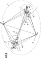
- Orientation here means the angle ⁇ 1 , ⁇ 2 formed between the respective longitudinal axis 1b, 2b of the submarine pipe and the line d connecting the respective centers of the flanges of the two submarine pipes (see figure 2 ).
- roll attitude is meant here the angle of rotation ⁇ 1 , ⁇ 2 around the respective longitudinal axis 1b, 2b of the pipes reflecting the lateral movements from right to left of the flanges of the pipes.
- pitch attitude is meant here the angle of rotation ⁇ 1 , ⁇ 2 around a transverse axis 1c, 2c perpendicular to the respective longitudinal axis 1b, 2b of the pipes reflecting the back and forth movements of the pipe flanges.
- a network of acoustic beacons of a monitoring system is positioned on the seabed.
- long-distance acoustic positioning called LBL for “Long BaseLine”.
- LBL long-distance acoustic positioning
- This known acoustic positioning system LBL is a geodetic network of limited and temporary range in which each acoustic beacon is positioned by measuring distance with the other beacons and having its known coordinates in this same geodetic reference frame.
- At least three acoustic beacons 11, 12, 13 are deployed on the seabed around the flange 1a of the pipe 1, at least three other acoustic beacons 21, 22, 23 around the flange 2a of the pipe 2 , and two additional acoustic beacons 31, 32.
- one of the three acoustic beacons deployed for each flange will be positioned in the immediate vicinity of the latter (on the example of the figure 2 , these are the acoustic beacons 11 and 21) in order to ensure quality control of the measurements.
- the acoustic beacons 11, 12, 13, 21, 22, 23 and 31, 32 each comprise means for transmitting and receiving acoustic signals and they are positioned relative to each other. to the others so that their places of positioning intersect at an angle greater than 30 °.
- some beacons are equipped with a pressure sensor making it possible to define a common reference plane on the Z axis.
- the LBL acoustic positioning system makes it possible to define a general three-dimensional reference which is relative or absolute and which covers the whole of the zone and in particular the two flanges 2a, 2b and all the acoustic beacons 11 , 12, 13, 21, 22, 23, 31 and 32.
- the general reference mark is said to be "relative" when it is obtained from a measurement of the distance between two beacons, one of these two beacons constituting the center of the reference mark and the axis connecting these two beacons together constituting the one of the axes.
- the figure 2 illustrates an example of such a relative general reference A (32, X, Y, Z).
- This reference A is defined from the two additional beacons 31, 32, the beacon 32 defining the center of the reference and the axis connecting the beacons 31, 32 together constituting the X axis.
- the reference mark is said to be “absolute” when it is obtained from an absolute coordinate system attached to a terrestrial coordinate system (for example to the GPS satellite geolocation system for “Global Positioning System”).
- the acoustic positioning system thus deployed is calibrated.
- the calibration of the network consists in carrying out the measurements of the distances between the acoustic beacons, in calculating the position of each beacon in the absolute or relative reference frame defined beforehand, and in adjusting the network.
- the adjustment of the network is carried out by means of suitable software implementing the method of least squares in order to refine the position of each beacon.
- step S3 of the method consists in deploying on the seabed an underwater vehicle provided with means for acquiring point clouds.
- these point cloud acquisition means are made up of any type of device making it possible to obtain a point cloud in real time or off-line, in particular laser scanners, acoustic scanners and devices. of photogrammetry.
- the underwater vehicle further comprises means for measuring the speed of sound in water.
- These means for measuring the speed of sound in water are used to obtain a precise speed of the propagation of sound and thus make it possible to adjust this parameter for the measuring means used such as acoustic scanners or measuring devices. inter-beacon distances.
- step S4 provision is made to perform, via the underwater vehicle, several scenes (or stations) around each flange 1a, 2a of the pipes 1, 2 so as to acquire a plurality of clouds of points around these flanges.
- the figure 3 shows an example of a scene take I around the flange 2a of the pipe 2.
- the underwater vehicle performs these acquisition stations while being stabilized on the seabed around each pipe flange.
- the different locations of these acquisition stations are defined and programmed beforehand to allow each point cloud obtained to necessarily include points representative of the target flange and of at least two acoustic beacons deployed around it.
- the image I comprises points representative of the flange 2a and the acoustic beacons 21 and 23.
- the coordinates of the points of the point clouds thus acquired and the coordinates of the points representative of the acoustic beacons deployed around the flange are known in the general absolute or relative reference A (32, X, Y, Z) defined by the LBL acoustic positioning system.
- the coordinates of the points of the point clouds and the coordinates of the points representative of the acoustic beacons deployed around the corresponding flange are known in a particular frame of reference centered on the position of the point cloud sensor fitted to the vehicle under -seaman during said scene.
- All the coordinates of the points of the point clouds acquired during the various scenes of the underwater vehicle are stored in a memory.
- step S5 the various point clouds acquired for each pipe flange are imported into point cloud processing software to be merged and form a single point cloud associated with each pipe flange.
- next step S6 consists in calculating the coordinates of the points of the set of point clouds thus merged into the general reference A (32, X, Y, Z) centered on the position of one two additional acoustic beacons (namely here the acoustic beacon 32).
- This calculation comprises the application of a known 3D transformation matrix to the points of the set of point clouds to obtain the coordinates of said points in the general frame of reference A (32, X, Y, Z).
- the transformation matrix typically comprises a translation matrix and a rotation matrix.
- the Support points of this rotation matrix are the acoustic beacons which are located around each flange and whose coordinates are known both in the general reference A (32, X, Y, Z) and in the global reference R1 ( O1, X, Y, Z), R2 (O2, X, Y, Z) associated with each flange.
- the method then provides, during a step S7, to calculate, using suitable software , the distance d , the pitch attitudes ⁇ 1 , ⁇ 2 and roll ⁇ 1 , ⁇ 2 , and the relative orientations ⁇ 1 , ⁇ 2 between the respective flanges 1a, 2a of two underwater pipes 1, 2.
Landscapes
- Engineering & Computer Science (AREA)
- Radar, Positioning & Navigation (AREA)
- Remote Sensing (AREA)
- Physics & Mathematics (AREA)
- General Physics & Mathematics (AREA)
- Computer Networks & Wireless Communication (AREA)
- General Engineering & Computer Science (AREA)
- Acoustics & Sound (AREA)
- Mechanical Engineering (AREA)
- Measurement Of Velocity Or Position Using Acoustic Or Ultrasonic Waves (AREA)
Claims (9)
- Kombiniertes metrologisches Verfahren zur Berechnung der Distanz, der Drehungs- und Neigungslagen sowie der relativen Orientierungen zwischen zwei unterseeischen Punkten von Interesse, umfassend der Reihe nach:die Positionierung (S1) eines Netzes von akustischen Signalgebern eines akustischen Ortungssystems über große Distanzen auf dem Meeresboden, mit der Ausbringung von zumindest drei akustischen Signalgebern (11, 12, 13, 21, 22, 23) um jeden Punkt von Interesse (1a, 2a) und der Ausbringung von zwei zusätzlichen akustischen Signalgebern (31, 32),die Kalibrierung (S2) des akustischen Ortungssystems über große Distanzen, um die relativen oder absoluten Positionen der akustischen Signalgeber zwischen einander zu bestimmen,die Ausbringung (S3) eines unterseeischen Fahrzeugs (40) auf dem Meeresboden, das mit Mitteln zur Erfassung von Punktwolken ausgestattet ist,die Erstellung (S4) mehrerer Szenarien durch das unterseeische Fahrzeug um jeden Punkt von Interesse herum, um mehrere Punktwolken (I) zu erfassen, die jeweils für einen Punkt von Interesse repräsentative Punkte und repräsentative Punkte von zumindest zwei akustischen Signalgebern, die um den Punkt von Interesse herum ausgebracht wurden, umfassen,die Verarbeitung (S5) der Punktwolken, um die Koordinaten von Punkten in einem selben Bereich A (32, X, Y, Z) zu berechnen (S6), der durch das Netz von akustischen Signalgebern definiert und an der Position von einem der akustischen Signalgeber zentriert ist, unddie Berechnung (S7) der Distanz (d), der Drehungs- (β1, β2) und Neigungslagen (γ1, γ2) und der relativen Orientierungen (α1, α2) zwischen den zwei Punkten von Interesse ausgehend von den Koordinaten der Punkte der Menge von Bildern in dem Bereich, der durch das Netz von akustischen Signalgebern definiert wird.
- Verfahren nach Anspruch 1, wobei die Verarbeitung der Punktwolken die Anwendung einer 3D-Transformationsmatrix umfasst, um die Koordinaten der Punkte in dem Bereich, der durch das Netz von akustischen Signalgebern definiert wird, zu erhalten.
- Verfahren nach Anspruch 2, wobei die Anwendung der 3D-Transformationsmatrix die Anwendung einer Verschiebungsmatrix und die Anwendung einer Drehungsmatrix umfasst.
- Verfahren nach einem der Ansprüche 1 bis 3, umfassend ferner die Fusion von Punktwolken, die mit jedem Punkt von Interesse assoziiert sind, vor der Verarbeitung der Punktwolken.
- Verfahren nach einem der Ansprüche 1 bis 4, wobei die akustischen Signalgeber des akustischen Ortungssystems über große Distanzen jeweils Mittel zum Aussenden und Empfangen von akustischen Signalen umfassen.
- Verfahren nach einem der Ansprüche 1 bis 5, wobei die Koordinaten von Punkten der Punktwolken und die Koordinaten von Punkten, die für die akustischen Signalgeber repräsentativ sind, die mit jedem Punkt von Interesse assoziiert sind, in einem absoluten oder relativen Bereich, der mit den akustischen Signalgebern assoziiert ist, die um jeden Punkt von Interesse herum ausgebracht wurden, bekannt sind.
- Verfahren nach einem der Ansprüche 1 bis 6, wobei das unterseeische Fahrzeug einen akustischen Scanner, einen Laserscanner oder eine fotogrammetrische Vorrichtung zum Erfassen der Punktwolken umfasst.
- Anwendung des Verfahrens nach einem der Ansprüche 1 bis 7 auf die Berechnung der Distanz, der Drehungs- und Neigungslagen sowie der relativen Orientierungen zwischen zwei Flanschen (1a, 2a) von unterseeischen Leitungen (1, 2) für den Transport von Fluiden.
- Anwendung nach Anspruch 8, bei welcher einer der drei ausgebrachten akustischen Signalgeber für jeden Leitungsflansch auf dem Leitungsflansch zum Zweck der Qualitätskontrolle positioniert wird.
Applications Claiming Priority (2)
| Application Number | Priority Date | Filing Date | Title |
|---|---|---|---|
| FR1751744A FR3063548B1 (fr) | 2017-03-03 | 2017-03-03 | Procede de metrologie combinee pour le calcul de la distance, des attitudes en roulis et tangage et des orientations relatives entre deux points d'interet sous-marins |
| PCT/FR2018/050428 WO2018158526A1 (fr) | 2017-03-03 | 2018-02-22 | Procédé de métrologie combinée pour le calcul de la distance, des attitudes en roulis et tangage et des orientations relatives entre deux points d'intérêt sous-marins |
Publications (2)
| Publication Number | Publication Date |
|---|---|
| EP3589977A1 EP3589977A1 (de) | 2020-01-08 |
| EP3589977B1 true EP3589977B1 (de) | 2021-03-31 |
Family
ID=59409403
Family Applications (1)
| Application Number | Title | Priority Date | Filing Date |
|---|---|---|---|
| EP18709689.6A Active EP3589977B1 (de) | 2017-03-03 | 2018-02-22 | Kombiniertes metrologieverfahren zur berechnung von abstand, drehungs- und neigungslagen und relativen orientierungen zwischen zwei unterwasserpunkten von interesse |
Country Status (11)
| Country | Link |
|---|---|
| US (1) | US11199607B2 (de) |
| EP (1) | EP3589977B1 (de) |
| CN (1) | CN110383104A (de) |
| AU (1) | AU2018226595B2 (de) |
| CA (1) | CA3049303C (de) |
| EA (1) | EA039284B1 (de) |
| FR (1) | FR3063548B1 (de) |
| MX (1) | MX2019010495A (de) |
| MY (1) | MY197492A (de) |
| WO (1) | WO2018158526A1 (de) |
| ZA (1) | ZA201905643B (de) |
Families Citing this family (4)
| Publication number | Priority date | Publication date | Assignee | Title |
|---|---|---|---|---|
| CN109765524B (zh) * | 2019-01-11 | 2019-12-17 | 国家深海基地管理中心 | 海底大地基准多信标定位平台及联合标校方法 |
| CN112824830B (zh) * | 2019-11-21 | 2023-08-22 | 中国石油天然气集团有限公司 | 水下管道定位方法 |
| CN114413846B (zh) * | 2022-01-07 | 2024-05-14 | 中海辉固地学服务(深圳)有限公司 | 基于长基线声学定位系统的深水跨接管安装测量方法 |
| CN116412839B (zh) * | 2023-03-09 | 2026-04-07 | 浙江省水利河口研究院(浙江省海洋规划设计研究院) | 水陆一体化点云测距系统及校准方法 |
Family Cites Families (6)
| Publication number | Priority date | Publication date | Assignee | Title |
|---|---|---|---|---|
| US4031544A (en) | 1975-08-11 | 1977-06-21 | Edo Western Corporation | Sonar/television system for use in underwater exploration |
| GB0102922D0 (en) * | 2001-02-06 | 2001-03-21 | Stolt Offshore Sa | Acoustic Metrology tool and method fo Metrology |
| US20120099400A1 (en) * | 2010-10-25 | 2012-04-26 | Lockheed Martin Corporation | Estimating position and orientation of an underwater vehicle relative to underwater structures |
| FR3006770B1 (fr) * | 2013-06-05 | 2016-12-09 | Ixblue | Procede et dispositif de metrologie pour la calibration de la geometrie d'un reseau de balises acoustiques sous-marines |
| AT515931B1 (de) * | 2015-01-22 | 2016-01-15 | Riegl Laser Measurement Sys | Vorrichtung zur Messung der Entfernung zu einem Objekt in einem Gewässer |
| CN105352476B (zh) * | 2015-11-23 | 2018-02-27 | 青岛秀山移动测量有限公司 | 船载水岸线水上水下一体化测量系统集成方法 |
-
2017
- 2017-03-03 FR FR1751744A patent/FR3063548B1/fr not_active Expired - Fee Related
-
2018
- 2018-02-22 EP EP18709689.6A patent/EP3589977B1/de active Active
- 2018-02-22 EA EA201992033A patent/EA039284B1/ru unknown
- 2018-02-22 MX MX2019010495A patent/MX2019010495A/es unknown
- 2018-02-22 MY MYPI2019004963A patent/MY197492A/en unknown
- 2018-02-22 CN CN201880015745.1A patent/CN110383104A/zh active Pending
- 2018-02-22 US US16/490,801 patent/US11199607B2/en active Active
- 2018-02-22 AU AU2018226595A patent/AU2018226595B2/en not_active Ceased
- 2018-02-22 CA CA3049303A patent/CA3049303C/fr not_active Expired - Fee Related
- 2018-02-22 WO PCT/FR2018/050428 patent/WO2018158526A1/fr not_active Ceased
-
2019
- 2019-08-27 ZA ZA2019/05643A patent/ZA201905643B/en unknown
Non-Patent Citations (1)
| Title |
|---|
| None * |
Also Published As
| Publication number | Publication date |
|---|---|
| MX2019010495A (es) | 2019-11-25 |
| FR3063548A1 (fr) | 2018-09-07 |
| EP3589977A1 (de) | 2020-01-08 |
| CA3049303A1 (fr) | 2018-09-07 |
| FR3063548B1 (fr) | 2019-04-12 |
| EA201992033A1 (ru) | 2020-02-10 |
| MY197492A (en) | 2023-06-19 |
| US11199607B2 (en) | 2021-12-14 |
| EA039284B1 (ru) | 2021-12-28 |
| AU2018226595B2 (en) | 2020-07-09 |
| ZA201905643B (en) | 2020-05-27 |
| US20200011964A1 (en) | 2020-01-09 |
| AU2018226595A1 (en) | 2019-08-01 |
| BR112019016502A2 (pt) | 2020-03-31 |
| CA3049303C (fr) | 2020-10-27 |
| CN110383104A (zh) | 2019-10-25 |
| WO2018158526A1 (fr) | 2018-09-07 |
Similar Documents
| Publication | Publication Date | Title |
|---|---|---|
| EP3589977B1 (de) | Kombiniertes metrologieverfahren zur berechnung von abstand, drehungs- und neigungslagen und relativen orientierungen zwischen zwei unterwasserpunkten von interesse | |
| US8903576B2 (en) | Device, program product and computer implemented method for touchless metrology using an inertial navigation system and laser | |
| WO2014195610A1 (fr) | Procédé et dispositif de métrologie pour la calibration de la géométrie d'un réseau de balises acoustiques sous-marines | |
| FR2739183A1 (fr) | Systeme de determination dynamique de la position et de l'orientation d'un reseau remorque | |
| WO2018142057A1 (fr) | Procédé et dispositif pour l'étalonnage d'un système de perception comportant un ensemble de télémètres lidar | |
| EP1019747B1 (de) | Verfahren zur korrektur von durch antennenschwankungen hervorgerufenen störeffekten für ein sonargerät mit synthetischer antenne | |
| WO2021014294A1 (fr) | Procede et dispositif de recalage d'une centrale inertielle | |
| EP1828802B1 (de) | Einrichtung zur autonomen bestimmung absoluter geographischer koordinaten einer sich in bezug auf immersion ändernden mobilen einrichtung | |
| EP0881505B1 (de) | Verfahren zur wiederholten Ortung für ein Fahrzeug mit Hilfe der Radar-Kartographie von unebenem Gelände | |
| WO2011124812A2 (fr) | Procédé de détermination de la position relative de deux détecteurs au fond de la mer | |
| OA19507A (fr) | Procédé de métrologie combinée pour le calcul de la distance, des attitudes en roulis et tangage et des orientations relatives entre deux points d'intérêt sous-marins. | |
| FR2926901A1 (fr) | Procede et dispositif de recuperation en immersion d'un engin sous-marin inhabite | |
| EP0247949A1 (de) | Verfahren und System zur Lokalisierung und Korrektur der Orientierung eines autonomen mobilen Objektes und eines nicht autonomen mobilen Objektes | |
| EP1691214B1 (de) | System zur Bestimmung der absoluten Position eines geschleppten Unterwasserfahrzeugs oder eines Unterwasserfahrzeugs mit Selbstantrieb | |
| EP4103958B1 (de) | Verfahren zur korrektur von positionsdaten zwischen zwei plattformen und zugehöriges verfahren zur inter-bezeichnung von bedrohungen | |
| EP0231707B1 (de) | Verfahren und Einrichtung zur Lagebestimmung eines Elements mit Ultraschallwandlern | |
| EP3980720B1 (de) | Verfahren und vorrichtung zum rücksetzen einer trägheitseinheit einer transportvorrichtung auf der basis von informationen, die von einem sucher der transportvorrichtung bereitgestellt werden | |
| BR112019016502B1 (pt) | Método de metrologia combinado para calcular distância, atitudes de arfagem e balanço e orientações relativas entre dois pontos submarinos de interesse, e aplicação do método | |
| WO2015161892A1 (en) | Optical underwater navigation |
Legal Events
| Date | Code | Title | Description |
|---|---|---|---|
| STAA | Information on the status of an ep patent application or granted ep patent |
Free format text: STATUS: UNKNOWN |
|
| STAA | Information on the status of an ep patent application or granted ep patent |
Free format text: STATUS: THE INTERNATIONAL PUBLICATION HAS BEEN MADE |
|
| PUAI | Public reference made under article 153(3) epc to a published international application that has entered the european phase |
Free format text: ORIGINAL CODE: 0009012 |
|
| STAA | Information on the status of an ep patent application or granted ep patent |
Free format text: STATUS: REQUEST FOR EXAMINATION WAS MADE |
|
| 17P | Request for examination filed |
Effective date: 20190911 |
|
| AK | Designated contracting states |
Kind code of ref document: A1 Designated state(s): AL AT BE BG CH CY CZ DE DK EE ES FI FR GB GR HR HU IE IS IT LI LT LU LV MC MK MT NL NO PL PT RO RS SE SI SK SM TR |
|
| AX | Request for extension of the european patent |
Extension state: BA ME |
|
| DAV | Request for validation of the european patent (deleted) | ||
| DAX | Request for extension of the european patent (deleted) | ||
| GRAP | Despatch of communication of intention to grant a patent |
Free format text: ORIGINAL CODE: EPIDOSNIGR1 |
|
| STAA | Information on the status of an ep patent application or granted ep patent |
Free format text: STATUS: GRANT OF PATENT IS INTENDED |
|
| RIC1 | Information provided on ipc code assigned before grant |
Ipc: G01S 15/86 20200101ALI20200928BHEP Ipc: G01S 15/89 20060101ALI20200928BHEP Ipc: B23K 37/04 20060101ALI20200928BHEP Ipc: G01S 15/02 20060101AFI20200928BHEP Ipc: G01S 5/18 20060101ALI20200928BHEP |
|
| INTG | Intention to grant announced |
Effective date: 20201104 |
|
| GRAS | Grant fee paid |
Free format text: ORIGINAL CODE: EPIDOSNIGR3 |
|
| GRAA | (expected) grant |
Free format text: ORIGINAL CODE: 0009210 |
|
| STAA | Information on the status of an ep patent application or granted ep patent |
Free format text: STATUS: THE PATENT HAS BEEN GRANTED |
|
| AK | Designated contracting states |
Kind code of ref document: B1 Designated state(s): AL AT BE BG CH CY CZ DE DK EE ES FI FR GB GR HR HU IE IS IT LI LT LU LV MC MK MT NL NO PL PT RO RS SE SI SK SM TR |
|
| REG | Reference to a national code |
Ref country code: GB Ref legal event code: FG4D Free format text: NOT ENGLISH Ref country code: CH Ref legal event code: EP |
|
| REG | Reference to a national code |
Ref country code: AT Ref legal event code: REF Ref document number: 1377561 Country of ref document: AT Kind code of ref document: T Effective date: 20210415 |
|
| REG | Reference to a national code |
Ref country code: DE Ref legal event code: R096 Ref document number: 602018014763 Country of ref document: DE |
|
| REG | Reference to a national code |
Ref country code: IE Ref legal event code: FG4D Free format text: LANGUAGE OF EP DOCUMENT: FRENCH |
|
| REG | Reference to a national code |
Ref country code: LT Ref legal event code: MG9D |
|
| PG25 | Lapsed in a contracting state [announced via postgrant information from national office to epo] |
Ref country code: HR Free format text: LAPSE BECAUSE OF FAILURE TO SUBMIT A TRANSLATION OF THE DESCRIPTION OR TO PAY THE FEE WITHIN THE PRESCRIBED TIME-LIMIT Effective date: 20210331 Ref country code: FI Free format text: LAPSE BECAUSE OF FAILURE TO SUBMIT A TRANSLATION OF THE DESCRIPTION OR TO PAY THE FEE WITHIN THE PRESCRIBED TIME-LIMIT Effective date: 20210331 Ref country code: BG Free format text: LAPSE BECAUSE OF FAILURE TO SUBMIT A TRANSLATION OF THE DESCRIPTION OR TO PAY THE FEE WITHIN THE PRESCRIBED TIME-LIMIT Effective date: 20210630 |
|
| REG | Reference to a national code |
Ref country code: NO Ref legal event code: T2 Effective date: 20210331 |
|
| PG25 | Lapsed in a contracting state [announced via postgrant information from national office to epo] |
Ref country code: LV Free format text: LAPSE BECAUSE OF FAILURE TO SUBMIT A TRANSLATION OF THE DESCRIPTION OR TO PAY THE FEE WITHIN THE PRESCRIBED TIME-LIMIT Effective date: 20210331 Ref country code: RS Free format text: LAPSE BECAUSE OF FAILURE TO SUBMIT A TRANSLATION OF THE DESCRIPTION OR TO PAY THE FEE WITHIN THE PRESCRIBED TIME-LIMIT Effective date: 20210331 Ref country code: SE Free format text: LAPSE BECAUSE OF FAILURE TO SUBMIT A TRANSLATION OF THE DESCRIPTION OR TO PAY THE FEE WITHIN THE PRESCRIBED TIME-LIMIT Effective date: 20210331 |
|
| REG | Reference to a national code |
Ref country code: NL Ref legal event code: MP Effective date: 20210331 |
|
| REG | Reference to a national code |
Ref country code: AT Ref legal event code: MK05 Ref document number: 1377561 Country of ref document: AT Kind code of ref document: T Effective date: 20210331 |
|
| PG25 | Lapsed in a contracting state [announced via postgrant information from national office to epo] |
Ref country code: LT Free format text: LAPSE BECAUSE OF FAILURE TO SUBMIT A TRANSLATION OF THE DESCRIPTION OR TO PAY THE FEE WITHIN THE PRESCRIBED TIME-LIMIT Effective date: 20210331 Ref country code: EE Free format text: LAPSE BECAUSE OF FAILURE TO SUBMIT A TRANSLATION OF THE DESCRIPTION OR TO PAY THE FEE WITHIN THE PRESCRIBED TIME-LIMIT Effective date: 20210331 Ref country code: CZ Free format text: LAPSE BECAUSE OF FAILURE TO SUBMIT A TRANSLATION OF THE DESCRIPTION OR TO PAY THE FEE WITHIN THE PRESCRIBED TIME-LIMIT Effective date: 20210331 Ref country code: SM Free format text: LAPSE BECAUSE OF FAILURE TO SUBMIT A TRANSLATION OF THE DESCRIPTION OR TO PAY THE FEE WITHIN THE PRESCRIBED TIME-LIMIT Effective date: 20210331 Ref country code: NL Free format text: LAPSE BECAUSE OF FAILURE TO SUBMIT A TRANSLATION OF THE DESCRIPTION OR TO PAY THE FEE WITHIN THE PRESCRIBED TIME-LIMIT Effective date: 20210331 Ref country code: AT Free format text: LAPSE BECAUSE OF FAILURE TO SUBMIT A TRANSLATION OF THE DESCRIPTION OR TO PAY THE FEE WITHIN THE PRESCRIBED TIME-LIMIT Effective date: 20210331 |
|
| PG25 | Lapsed in a contracting state [announced via postgrant information from national office to epo] |
Ref country code: SK Free format text: LAPSE BECAUSE OF FAILURE TO SUBMIT A TRANSLATION OF THE DESCRIPTION OR TO PAY THE FEE WITHIN THE PRESCRIBED TIME-LIMIT Effective date: 20210331 Ref country code: RO Free format text: LAPSE BECAUSE OF FAILURE TO SUBMIT A TRANSLATION OF THE DESCRIPTION OR TO PAY THE FEE WITHIN THE PRESCRIBED TIME-LIMIT Effective date: 20210331 Ref country code: PL Free format text: LAPSE BECAUSE OF FAILURE TO SUBMIT A TRANSLATION OF THE DESCRIPTION OR TO PAY THE FEE WITHIN THE PRESCRIBED TIME-LIMIT Effective date: 20210331 Ref country code: PT Free format text: LAPSE BECAUSE OF FAILURE TO SUBMIT A TRANSLATION OF THE DESCRIPTION OR TO PAY THE FEE WITHIN THE PRESCRIBED TIME-LIMIT Effective date: 20210802 Ref country code: IS Free format text: LAPSE BECAUSE OF FAILURE TO SUBMIT A TRANSLATION OF THE DESCRIPTION OR TO PAY THE FEE WITHIN THE PRESCRIBED TIME-LIMIT Effective date: 20210731 |
|
| REG | Reference to a national code |
Ref country code: DE Ref legal event code: R097 Ref document number: 602018014763 Country of ref document: DE |
|
| PG25 | Lapsed in a contracting state [announced via postgrant information from national office to epo] |
Ref country code: AL Free format text: LAPSE BECAUSE OF FAILURE TO SUBMIT A TRANSLATION OF THE DESCRIPTION OR TO PAY THE FEE WITHIN THE PRESCRIBED TIME-LIMIT Effective date: 20210331 Ref country code: DK Free format text: LAPSE BECAUSE OF FAILURE TO SUBMIT A TRANSLATION OF THE DESCRIPTION OR TO PAY THE FEE WITHIN THE PRESCRIBED TIME-LIMIT Effective date: 20210331 Ref country code: ES Free format text: LAPSE BECAUSE OF FAILURE TO SUBMIT A TRANSLATION OF THE DESCRIPTION OR TO PAY THE FEE WITHIN THE PRESCRIBED TIME-LIMIT Effective date: 20210331 |
|
| PLBE | No opposition filed within time limit |
Free format text: ORIGINAL CODE: 0009261 |
|
| STAA | Information on the status of an ep patent application or granted ep patent |
Free format text: STATUS: NO OPPOSITION FILED WITHIN TIME LIMIT |
|
| 26N | No opposition filed |
Effective date: 20220104 |
|
| PG25 | Lapsed in a contracting state [announced via postgrant information from national office to epo] |
Ref country code: IS Free format text: LAPSE BECAUSE OF FAILURE TO SUBMIT A TRANSLATION OF THE DESCRIPTION OR TO PAY THE FEE WITHIN THE PRESCRIBED TIME-LIMIT Effective date: 20210731 |
|
| PG25 | Lapsed in a contracting state [announced via postgrant information from national office to epo] |
Ref country code: IT Free format text: LAPSE BECAUSE OF FAILURE TO SUBMIT A TRANSLATION OF THE DESCRIPTION OR TO PAY THE FEE WITHIN THE PRESCRIBED TIME-LIMIT Effective date: 20210331 |
|
| REG | Reference to a national code |
Ref country code: DE Ref legal event code: R119 Ref document number: 602018014763 Country of ref document: DE |
|
| PG25 | Lapsed in a contracting state [announced via postgrant information from national office to epo] |
Ref country code: MC Free format text: LAPSE BECAUSE OF FAILURE TO SUBMIT A TRANSLATION OF THE DESCRIPTION OR TO PAY THE FEE WITHIN THE PRESCRIBED TIME-LIMIT Effective date: 20210331 |
|
| REG | Reference to a national code |
Ref country code: CH Ref legal event code: PL |
|
| REG | Reference to a national code |
Ref country code: BE Ref legal event code: MM Effective date: 20220228 |
|
| PG25 | Lapsed in a contracting state [announced via postgrant information from national office to epo] |
Ref country code: LU Free format text: LAPSE BECAUSE OF NON-PAYMENT OF DUE FEES Effective date: 20220222 |
|
| PG25 | Lapsed in a contracting state [announced via postgrant information from national office to epo] |
Ref country code: LI Free format text: LAPSE BECAUSE OF NON-PAYMENT OF DUE FEES Effective date: 20220228 Ref country code: IE Free format text: LAPSE BECAUSE OF NON-PAYMENT OF DUE FEES Effective date: 20220222 Ref country code: DE Free format text: LAPSE BECAUSE OF NON-PAYMENT OF DUE FEES Effective date: 20220901 Ref country code: CH Free format text: LAPSE BECAUSE OF NON-PAYMENT OF DUE FEES Effective date: 20220228 |
|
| PG25 | Lapsed in a contracting state [announced via postgrant information from national office to epo] |
Ref country code: BE Free format text: LAPSE BECAUSE OF NON-PAYMENT OF DUE FEES Effective date: 20220228 |
|
| P01 | Opt-out of the competence of the unified patent court (upc) registered |
Effective date: 20230517 |
|
| PG25 | Lapsed in a contracting state [announced via postgrant information from national office to epo] |
Ref country code: MK Free format text: LAPSE BECAUSE OF FAILURE TO SUBMIT A TRANSLATION OF THE DESCRIPTION OR TO PAY THE FEE WITHIN THE PRESCRIBED TIME-LIMIT Effective date: 20210331 Ref country code: CY Free format text: LAPSE BECAUSE OF FAILURE TO SUBMIT A TRANSLATION OF THE DESCRIPTION OR TO PAY THE FEE WITHIN THE PRESCRIBED TIME-LIMIT Effective date: 20210331 |
|
| PG25 | Lapsed in a contracting state [announced via postgrant information from national office to epo] |
Ref country code: HU Free format text: LAPSE BECAUSE OF FAILURE TO SUBMIT A TRANSLATION OF THE DESCRIPTION OR TO PAY THE FEE WITHIN THE PRESCRIBED TIME-LIMIT; INVALID AB INITIO Effective date: 20180222 |
|
| PG25 | Lapsed in a contracting state [announced via postgrant information from national office to epo] |
Ref country code: TR Free format text: LAPSE BECAUSE OF FAILURE TO SUBMIT A TRANSLATION OF THE DESCRIPTION OR TO PAY THE FEE WITHIN THE PRESCRIBED TIME-LIMIT Effective date: 20210331 |
|
| PG25 | Lapsed in a contracting state [announced via postgrant information from national office to epo] |
Ref country code: MT Free format text: LAPSE BECAUSE OF FAILURE TO SUBMIT A TRANSLATION OF THE DESCRIPTION OR TO PAY THE FEE WITHIN THE PRESCRIBED TIME-LIMIT Effective date: 20210331 |
|
| PG25 | Lapsed in a contracting state [announced via postgrant information from national office to epo] |
Ref country code: GR Free format text: LAPSE BECAUSE OF NON-PAYMENT OF DUE FEES Effective date: 20210331 |
|
| PG25 | Lapsed in a contracting state [announced via postgrant information from national office to epo] |
Ref country code: GR Free format text: LAPSE BECAUSE OF NON-PAYMENT OF DUE FEES Effective date: 20210331 |
|
| PGFP | Annual fee paid to national office [announced via postgrant information from national office to epo] |
Ref country code: GB Payment date: 20260219 Year of fee payment: 9 |
|
| PGFP | Annual fee paid to national office [announced via postgrant information from national office to epo] |
Ref country code: NO Payment date: 20260127 Year of fee payment: 9 |
|
| PGFP | Annual fee paid to national office [announced via postgrant information from national office to epo] |
Ref country code: FR Payment date: 20260218 Year of fee payment: 9 |