EP3572840A1 - Unmanned guide vehicle with a groundbased radar - Google Patents
Unmanned guide vehicle with a groundbased radar Download PDFInfo
- Publication number
- EP3572840A1 EP3572840A1 EP19168463.8A EP19168463A EP3572840A1 EP 3572840 A1 EP3572840 A1 EP 3572840A1 EP 19168463 A EP19168463 A EP 19168463A EP 3572840 A1 EP3572840 A1 EP 3572840A1
- Authority
- EP
- European Patent Office
- Prior art keywords
- vehicle
- radar
- data
- ground radar
- ground
- Prior art date
- Legal status (The legal status is an assumption and is not a legal conclusion. Google has not performed a legal analysis and makes no representation as to the accuracy of the status listed.)
- Pending
Links
- 238000011156 evaluation Methods 0.000 claims abstract description 13
- 238000001514 detection method Methods 0.000 claims description 10
- 238000000034 method Methods 0.000 claims description 7
- 238000012876 topography Methods 0.000 claims description 6
- 230000005540 biological transmission Effects 0.000 claims description 3
- 238000004891 communication Methods 0.000 description 5
- 239000002360 explosive Substances 0.000 description 5
- 230000000737 periodic effect Effects 0.000 description 2
- 230000000630 rising effect Effects 0.000 description 2
- 238000005516 engineering process Methods 0.000 description 1
- 239000002184 metal Substances 0.000 description 1
- 230000005855 radiation Effects 0.000 description 1
Images

Classifications
-
- G—PHYSICS
- G01—MEASURING; TESTING
- G01S—RADIO DIRECTION-FINDING; RADIO NAVIGATION; DETERMINING DISTANCE OR VELOCITY BY USE OF RADIO WAVES; LOCATING OR PRESENCE-DETECTING BY USE OF THE REFLECTION OR RERADIATION OF RADIO WAVES; ANALOGOUS ARRANGEMENTS USING OTHER WAVES
- G01S7/00—Details of systems according to groups G01S13/00, G01S15/00, G01S17/00
- G01S7/02—Details of systems according to groups G01S13/00, G01S15/00, G01S17/00 of systems according to group G01S13/00
- G01S7/41—Details of systems according to groups G01S13/00, G01S15/00, G01S17/00 of systems according to group G01S13/00 using analysis of echo signal for target characterisation; Target signature; Target cross-section
- G01S7/411—Identification of targets based on measurements of radar reflectivity
- G01S7/412—Identification of targets based on measurements of radar reflectivity based on a comparison between measured values and known or stored values
-
- F—MECHANICAL ENGINEERING; LIGHTING; HEATING; WEAPONS; BLASTING
- F41—WEAPONS
- F41H—ARMOUR; ARMOURED TURRETS; ARMOURED OR ARMED VEHICLES; MEANS OF ATTACK OR DEFENCE, e.g. CAMOUFLAGE, IN GENERAL
- F41H11/00—Defence installations; Defence devices
- F41H11/12—Means for clearing land minefields; Systems specially adapted for detection of landmines
- F41H11/13—Systems specially adapted for detection of landmines
- F41H11/136—Magnetic, electromagnetic, acoustic or radiation systems, e.g. ground penetrating radars or metal-detectors
-
- G—PHYSICS
- G01—MEASURING; TESTING
- G01S—RADIO DIRECTION-FINDING; RADIO NAVIGATION; DETERMINING DISTANCE OR VELOCITY BY USE OF RADIO WAVES; LOCATING OR PRESENCE-DETECTING BY USE OF THE REFLECTION OR RERADIATION OF RADIO WAVES; ANALOGOUS ARRANGEMENTS USING OTHER WAVES
- G01S13/00—Systems using the reflection or reradiation of radio waves, e.g. radar systems; Analogous systems using reflection or reradiation of waves whose nature or wavelength is irrelevant or unspecified
- G01S13/02—Systems using reflection of radio waves, e.g. primary radar systems; Analogous systems
- G01S13/06—Systems determining position data of a target
- G01S13/42—Simultaneous measurement of distance and other co-ordinates
- G01S13/426—Scanning radar, e.g. 3D radar
-
- G—PHYSICS
- G01—MEASURING; TESTING
- G01S—RADIO DIRECTION-FINDING; RADIO NAVIGATION; DETERMINING DISTANCE OR VELOCITY BY USE OF RADIO WAVES; LOCATING OR PRESENCE-DETECTING BY USE OF THE REFLECTION OR RERADIATION OF RADIO WAVES; ANALOGOUS ARRANGEMENTS USING OTHER WAVES
- G01S13/00—Systems using the reflection or reradiation of radio waves, e.g. radar systems; Analogous systems using reflection or reradiation of waves whose nature or wavelength is irrelevant or unspecified
- G01S13/88—Radar or analogous systems specially adapted for specific applications
- G01S13/885—Radar or analogous systems specially adapted for specific applications for ground probing
-
- G—PHYSICS
- G01—MEASURING; TESTING
- G01S—RADIO DIRECTION-FINDING; RADIO NAVIGATION; DETERMINING DISTANCE OR VELOCITY BY USE OF RADIO WAVES; LOCATING OR PRESENCE-DETECTING BY USE OF THE REFLECTION OR RERADIATION OF RADIO WAVES; ANALOGOUS ARRANGEMENTS USING OTHER WAVES
- G01S13/00—Systems using the reflection or reradiation of radio waves, e.g. radar systems; Analogous systems using reflection or reradiation of waves whose nature or wavelength is irrelevant or unspecified
- G01S13/88—Radar or analogous systems specially adapted for specific applications
- G01S13/93—Radar or analogous systems specially adapted for specific applications for anti-collision purposes
- G01S13/931—Radar or analogous systems specially adapted for specific applications for anti-collision purposes of land vehicles
-
- G—PHYSICS
- G01—MEASURING; TESTING
- G01S—RADIO DIRECTION-FINDING; RADIO NAVIGATION; DETERMINING DISTANCE OR VELOCITY BY USE OF RADIO WAVES; LOCATING OR PRESENCE-DETECTING BY USE OF THE REFLECTION OR RERADIATION OF RADIO WAVES; ANALOGOUS ARRANGEMENTS USING OTHER WAVES
- G01S7/00—Details of systems according to groups G01S13/00, G01S15/00, G01S17/00
- G01S7/003—Transmission of data between radar, sonar or lidar systems and remote stations
- G01S7/006—Transmission of data between radar, sonar or lidar systems and remote stations using shared front-end circuitry, e.g. antennas
-
- G—PHYSICS
- G05—CONTROLLING; REGULATING
- G05D—SYSTEMS FOR CONTROLLING OR REGULATING NON-ELECTRIC VARIABLES
- G05D1/00—Control of position, course, altitude or attitude of land, water, air or space vehicles, e.g. using automatic pilots
- G05D1/02—Control of position or course in two dimensions
- G05D1/021—Control of position or course in two dimensions specially adapted to land vehicles
- G05D1/0257—Control of position or course in two dimensions specially adapted to land vehicles using a radar
-
- G—PHYSICS
- G05—CONTROLLING; REGULATING
- G05D—SYSTEMS FOR CONTROLLING OR REGULATING NON-ELECTRIC VARIABLES
- G05D1/00—Control of position, course, altitude or attitude of land, water, air or space vehicles, e.g. using automatic pilots
- G05D1/02—Control of position or course in two dimensions
- G05D1/021—Control of position or course in two dimensions specially adapted to land vehicles
- G05D1/0287—Control of position or course in two dimensions specially adapted to land vehicles involving a plurality of land vehicles, e.g. fleet or convoy travelling
- G05D1/0291—Fleet control
- G05D1/0293—Convoy travelling
-
- G—PHYSICS
- G05—CONTROLLING; REGULATING
- G05D—SYSTEMS FOR CONTROLLING OR REGULATING NON-ELECTRIC VARIABLES
- G05D1/00—Control of position, course, altitude or attitude of land, water, air or space vehicles, e.g. using automatic pilots
- G05D1/02—Control of position or course in two dimensions
- G05D1/021—Control of position or course in two dimensions specially adapted to land vehicles
- G05D1/0287—Control of position or course in two dimensions specially adapted to land vehicles involving a plurality of land vehicles, e.g. fleet or convoy travelling
- G05D1/0291—Fleet control
- G05D1/0295—Fleet control by at least one leading vehicle of the fleet
-
- G—PHYSICS
- G08—SIGNALLING
- G08G—TRAFFIC CONTROL SYSTEMS
- G08G1/00—Traffic control systems for road vehicles
- G08G1/22—Platooning, i.e. convoy of communicating vehicles
-
- F—MECHANICAL ENGINEERING; LIGHTING; HEATING; WEAPONS; BLASTING
- F41—WEAPONS
- F41H—ARMOUR; ARMOURED TURRETS; ARMOURED OR ARMED VEHICLES; MEANS OF ATTACK OR DEFENCE, e.g. CAMOUFLAGE, IN GENERAL
- F41H11/00—Defence installations; Defence devices
- F41H11/12—Means for clearing land minefields; Systems specially adapted for detection of landmines
- F41H11/16—Self-propelled mine-clearing vehicles; Mine-clearing devices attachable to vehicles
- F41H11/32—Decoy or sacrificial vehicles; Decoy or sacrificial devices attachable to vehicles
-
- G—PHYSICS
- G01—MEASURING; TESTING
- G01S—RADIO DIRECTION-FINDING; RADIO NAVIGATION; DETERMINING DISTANCE OR VELOCITY BY USE OF RADIO WAVES; LOCATING OR PRESENCE-DETECTING BY USE OF THE REFLECTION OR RERADIATION OF RADIO WAVES; ANALOGOUS ARRANGEMENTS USING OTHER WAVES
- G01S13/00—Systems using the reflection or reradiation of radio waves, e.g. radar systems; Analogous systems using reflection or reradiation of waves whose nature or wavelength is irrelevant or unspecified
- G01S13/02—Systems using reflection of radio waves, e.g. primary radar systems; Analogous systems
- G01S2013/0236—Special technical features
- G01S2013/0245—Radar with phased array antenna
- G01S2013/0254—Active array antenna
-
- G—PHYSICS
- G01—MEASURING; TESTING
- G01S—RADIO DIRECTION-FINDING; RADIO NAVIGATION; DETERMINING DISTANCE OR VELOCITY BY USE OF RADIO WAVES; LOCATING OR PRESENCE-DETECTING BY USE OF THE REFLECTION OR RERADIATION OF RADIO WAVES; ANALOGOUS ARRANGEMENTS USING OTHER WAVES
- G01S13/00—Systems using the reflection or reradiation of radio waves, e.g. radar systems; Analogous systems using reflection or reradiation of waves whose nature or wavelength is irrelevant or unspecified
- G01S13/88—Radar or analogous systems specially adapted for specific applications
- G01S13/93—Radar or analogous systems specially adapted for specific applications for anti-collision purposes
- G01S13/931—Radar or analogous systems specially adapted for specific applications for anti-collision purposes of land vehicles
- G01S2013/9316—Radar or analogous systems specially adapted for specific applications for anti-collision purposes of land vehicles combined with communication equipment with other vehicles or with base stations
-
- G—PHYSICS
- G01—MEASURING; TESTING
- G01S—RADIO DIRECTION-FINDING; RADIO NAVIGATION; DETERMINING DISTANCE OR VELOCITY BY USE OF RADIO WAVES; LOCATING OR PRESENCE-DETECTING BY USE OF THE REFLECTION OR RERADIATION OF RADIO WAVES; ANALOGOUS ARRANGEMENTS USING OTHER WAVES
- G01S13/00—Systems using the reflection or reradiation of radio waves, e.g. radar systems; Analogous systems using reflection or reradiation of waves whose nature or wavelength is irrelevant or unspecified
- G01S13/88—Radar or analogous systems specially adapted for specific applications
- G01S13/93—Radar or analogous systems specially adapted for specific applications for anti-collision purposes
- G01S13/931—Radar or analogous systems specially adapted for specific applications for anti-collision purposes of land vehicles
- G01S2013/9325—Radar or analogous systems specially adapted for specific applications for anti-collision purposes of land vehicles for inter-vehicle distance regulation, e.g. navigating in platoons
Definitions
- the invention relates to an unmanned vehicle and a vehicle convoy with the features of the independent claims.
- the field of the invention relates in particular to safe navigation through a minefield.
- the radar system has a transmitting unit for transmitting radar signals.
- a first modulator provides the radiated radar signal with a periodic waveform.
- the periodic waveform has a rising area, a falling area and a constant frequency area.
- a second modulator modulates the constant frequency range with a data signal. This data signal can be decoded by a receiver.
- the method employs a leader vehicle having at least one follower vehicle with the leader vehicle in communication with the follower vehicle.
- the at least one follower vehicle receives communication regarding a destination offset position and route data.
- the route data is provided with tracking data for identifying a Accuracy compared between the route data relative to the tracking data.
- the route data includes a global position and GPS data of the leading vehicle.
- the invention is based on the object to improve the unmanned leader vehicle.
- the unmanned leader vehicle is capable of guiding the vehicle crew.
- the data connection is radar-based.
- a radar signal is emitted by the unmanned leading vehicle, wherein the radar signal has data information.
- the data information is modulated on a radar carrier signal.
- the follower vehicle has a radar sensor that is adapted to receive the radar signal emitted by the leading vehicle.
- the radar signal is decoded by an evaluation unit of the following vehicle and the data information is extracted.
- the invention has the advantage that when a mine is not recognized, only the unmanned leading vehicle is affected. An efficient combined use of the ground radar as a detector and as a data transmitter is therefore possible. There is no wireless connection or other method of communication between the vehicles necessary. However, it is possible that a radio link or other communication method exists between the follower vehicles.
- the data signal includes information regarding the position of the leading vehicle and / or the position of recognized mines and / or a proposed route.
- the route through the minefield is determined by board electronics with a memory, a processor and corresponding software of the leading vehicle.
- the route can also be determined automatically by on-board electronics of the following vehicle.
- the route is determined by an operator of the follower vehicle.
- the ground radar of the leading vehicle objects are detected on or in the underground of the route ahead. For this purpose, at least part of the predicted route is detected with the ground radar of the leading vehicle.
- the sensor data of the ground radar also serve to detect the objects, which may be classified as explosive or non-explosive.
- the corresponding detected objects are analyzed by means of an evaluation and / or control unit and possibly classified as an explosive device and depending on the classification as an explosive device, the unmanned vehicle is controlled on a route evading the mine.
- the data of the ground radar are compared with existing comparison data of known mine types from a database. Upon detection of a known mine from the database, the leading vehicle steers by means of the evaluation and control unit at a safe distance past the mine.
- ground radar data concerning the position of the leading vehicle are generated.
- the position of the leading vehicle can be determined by means of a GPS sensor.
- the topography of the route and / or the condition of the subsoil is detected by the ground radar.
- These data namely the position of the vehicle and / or the detected objects and / or the topography of the route and / or the nature of the ground are sent to a follower vehicle. This data is sent via the radar link to the following vehicle.
- the information about the position of the vehicle and / or the mines and / or the topography data of the route are sent by means of the ground radar to a subsequent vehicle.
- the information is modulated onto the transmission signal of the ground radar.
- the transmitted data is transmitted continuously, so that the following vehicle receives the exact route of the leading vehicle.
- the position information can include absolute or relative position information.
- the data may also show a map of the nature of the ground, the detected objects in or on the ground, on the basis of which data the following vehicle can independently navigate.
- the follow-up vehicle uses its own ground radar to capture even the ground, to compare with the sent map of the leading vehicle and thereby independently determine their own position, navigate and avoid the mines.
- the data can also be sent by radar from one following vehicle to the next following vehicle.
- all following vehicles have a corresponding ground radar.
- the radar is an AESA (Active Electronically Scanned Array) radar panel.
- the ground radar is preferably arranged on the underbody of the vehicle such that the detection field extends 360 ° around the vehicle.
- the ground radar can also be made pivotable about a horizontal position, so that a further radiation of the radar field can be achieved. It is conceivable to execute the floor radar in such a pivotable manner that it can now be pivoted into a position which is at an angle to the ground. The pivoting is particularly useful if the distance to the next following vehicle is large and this would not be achieved by the radar without pivoting.
- the ground radar can also consist of several radars covering different directions and preferably radiate towards the ground at an angle between 0 ° and 60 ° relative to the horizon.
- the radars may alternatively also be arranged on the sides of the guide or follower vehicle or on the guide or follower vehicle.
- the method is used in particular for navigating a vehicle column through a minefield.
- unknown objects are detected on a preceding route and preferably in the environment.
- the recorded data is sent from the leader vehicle to the at least one follower vehicle.
- the data is sent by means of the ground radar to the following vehicle.
- the following vehicle also detects the route with a ground radar.
- the position of the follower vehicle is determined based on a comparison of the measured data of the following vehicle's ground radar and the data received from the lead vehicle. As a result, a more accurate position determination than with GPS can be achieved.
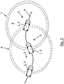
- Fig. 1 is a vehicle convoy 1 with an unmanned leader vehicle 2 and two followers 3 clearly visible.
- the vehicle convoy 1 moves through a minefield 4 with several mines 5.
- the leading vehicle 2 and preferably also the following vehicles 3 each have a ground radar 6.
- the ground radar 6 has a detection area 7, 8.
- the preceding unmanned leader vehicle 2 is used. This is with the ground radar 6 for the detection of objects, in particular the mines 5 equipped on the route 9.
- the route 9 is chosen so that a contact of the leading vehicle 2 and the following vehicles 3 with the mines 5 is avoided.
- an evaluation and control unit By means of an evaluation and control unit, not shown, objects along the route 9, namely in particular in the detection areas 7, 8 are analyzed and thereby mines 5 are detected. To detect the mines, the data of the ground radar 6 are compared with existing comparison data of known mine types from a database.
- the database is stored in particular in the evaluation and control unit of the leading vehicle 2.
- all vehicles, namely the follower vehicles 3, have a corresponding evaluation and control unit with corresponding comparison data.
- the vehicle namely, in particular, the leading vehicle 2 and also the following vehicles 3 are navigated past the mine 5.
- the information about the position of the leading vehicle 2 and / or the mines 5 and / or the topography data of the route are sent by means of the ground radar 6 to a subsequent vehicle.
- the information is modulated on the transmission signal of the ground radar 6.
- the data is transmitted continuously, so that the following vehicle 3 receives the exact route 9 of the leading vehicle 2.
- the follower vehicles 3 detect the radar signal of the leading vehicle 2 with the ground radar 6.
- the topography data of the travel path 9 are also detected, preferably with the ground radar 6 and the following vehicles 3.
- the position information can be absolute or relative position information.
- the data may also include a map of the nature of the subsurface comprising the detected objects in or on the ground, by means of which the following vehicle 3 can independently navigate.
- the follower vehicle 3 uses its own ground radar 6 in order to detect the ground itself and to compare the recorded data with the transmitted map of the leading vehicle 2 and thereby autonomously navigate and avoid the mines 5.
- the data can also be transmitted from one vehicle to the next radar in the case of larger vehicle columns 1.
- the radar is an AESA (Active Electronically Scanned Array) radar.
- the ground radar 6 is preferably arranged on the ground of the leading vehicle 2 or on the ground of the following vehicle 3 such that the detection field extends 360 ° around the vehicle.
- the ground radar 6 is preferably pivotable so that the ground radar 6 can pivot into a horizontal position even when the terrain is rising so that further radiant emission of the radar can be achieved. Furthermore, it can be achieved by the pivoting, when the distance to the follower vehicle 3 is large and this would not otherwise be achieved by the radar field, that the ground radar 6 is pivoted to the following vehicle 3.
- the ground radar 6 may also consist of several radars Radarsensoren exist, which cover different orientations and radiate preferably at an angle between 0 ° and 60 ° relative to the horizon towards the ground.
- the ground radars 6 can alternatively also be arranged on the sides of the vehicle 2, 3 or on the vehicle 2, 3.
Landscapes
- Engineering & Computer Science (AREA)
- Radar, Positioning & Navigation (AREA)
- Remote Sensing (AREA)
- Physics & Mathematics (AREA)
- General Physics & Mathematics (AREA)
- Computer Networks & Wireless Communication (AREA)
- Electromagnetism (AREA)
- Aviation & Aerospace Engineering (AREA)
- Automation & Control Theory (AREA)
- Acoustics & Sound (AREA)
- General Engineering & Computer Science (AREA)
- Traffic Control Systems (AREA)
Abstract
Die Erfindung betrifft ein unbemanntes Führungsfahrzeug (2) mit einem Bodenradar und mit einer Auswerte- und Steuerungseinheit, wobei mittels des Bodenradars (6) unbekannte Objekte auf einer vorausliegenden Fahrstrecke (9) detektierbar sind.Das Führungsfahrzeug (2) ist dadurch verbessert, dass das Führungsfahrzeug (2) zur Führung einer Fahrzeugkolonne (1) mit weiteren Folgefahrzeugen (3) ausgebildet ist, wobei Daten von dem Führungsfahrzeug (2) an das mindestens eine Folgefahrzeug (3) sendbar sind, wobei die Daten mittels des Bodenradars (6) an das Folgefahrzeug (3) sendbar sind.The invention relates to an unmanned command vehicle (2) having a ground radar and to an evaluation and control unit, wherein unknown objects can be detected on a preceding route (9) by means of the ground radar (6). The leading vehicle (2) is improved in that the Guide vehicle (2) for guiding a vehicle convoy (1) with further follower vehicles (3) is formed, wherein data from the leading vehicle (2) to the at least one follower vehicle (3) can be transmitted, wherein the data by means of the ground radar (6) to the Follower vehicle (3) are sendbar.
Description
Die Erfindung betrifft ein unbemanntes Fahrzeug und eine Fahrzeugkolonne mit den Merkmalen der unabhängigen Patentansprüche.The invention relates to an unmanned vehicle and a vehicle convoy with the features of the independent claims.
Das Gebiet der Erfindung betrifft insbesondere die sichere Navigation durch ein Minenfeld.The field of the invention relates in particular to safe navigation through a minefield.
Aus der gattungsbildenden
Aus der
Aus der
Aus der
Der Erfindung liegt nun die Aufgabe zugrunde, das unbemannte Führungsfahrzeug zu verbessern.The invention is based on the object to improve the unmanned leader vehicle.
Diese der Erfindung zugrunde liegende Aufgabe wird nun durch ein unbemanntes Führungsfahrzeug und durch eine Fahrzeugkolonne mit den Merkmalen der unabhängigen Patentansprüche gelöst.This object of the invention is now achieved by an unmanned leader vehicle and by a vehicle convoy with the features of the independent claims.
Mittels des unbemannten Führungsfahrzeugs einer Fahrzeugkolonne werden mit einem Bodenradar Minen detektiert und Informationen zur Umfahrung der Minen werden mittels des Bodenradars an ein nachfolgendes Fahrzeug, das sogenannte Folgefahrzeug, gesendet. Hierdurch ist ein unbemanntes Führungsfahrzeug zur sicheren Navigation einer Fahrzeugkolonne durch ein Minenfeld und ein entsprechendes Verfahren offenbart. Das unbemannte Führungsfahrzeug ist dazu geeignet, die Fahrzeugkolonne zu führen. Hierdurch besteht eine Datenverbindung zwischen dem Führungsfahrzeug und dem mindestens einen Folgefahrzeug. Die Datenverbindung ist radarbasiert. Hierzu wird ein Radarsignal von dem unbemannten Führungsfahrzeug ausgesandt, wobei das Radarsignal Dateninformationen aufweist. Die Dateninformationen sind auf einem Radarträgersignal aufmoduliert. Das Folgefahrzeug weist einen Radarsensor auf, der dazu geeignet ist, das von dem Führungsfahrzeug ausgesandte Radarsignal zu empfangen. Das Radarsignal wird von einer Auswerteeinheit des Folgefahrzeugs dekodiert und die Dateninformationen werden extrahiert.By means of the unmanned leading vehicle of a vehicle convoy, mines are detected with a ground radar, and information about the detour of the mines is transmitted by means of the ground radar to a following vehicle, the so-called following vehicle. As a result, an unmanned command vehicle for safely navigating a vehicle convoy through a minefield and a corresponding method is disclosed. The unmanned leader vehicle is capable of guiding the vehicle crew. As a result, there is a data connection between the leading vehicle and the at least one following vehicle. The data connection is radar-based. For this purpose, a radar signal is emitted by the unmanned leading vehicle, wherein the radar signal has data information. The data information is modulated on a radar carrier signal. The follower vehicle has a radar sensor that is adapted to receive the radar signal emitted by the leading vehicle. The radar signal is decoded by an evaluation unit of the following vehicle and the data information is extracted.
Die Erfindung hat den Vorteil, dass bei einer Nichterkennung einer Mine nur das unbemannte Führungsfahrzeug betroffen ist. Eine effiziente kombinierte Nutzung des Bodenradars als Detektor und als Datensender ist daher möglich. Es ist keine Funkverbindung oder andere Kommunikationsmethode zwischen den Fahrzeugen notwendig. Es ist jedoch möglich, dass eine Funkverbindung oder eine andere Kommunikationsmethode zwischen den Folgefahrzeugen besteht.The invention has the advantage that when a mine is not recognized, only the unmanned leading vehicle is affected. An efficient combined use of the ground radar as a detector and as a data transmitter is therefore possible. There is no wireless connection or other method of communication between the vehicles necessary. However, it is possible that a radio link or other communication method exists between the follower vehicles.
Das Datensignal umfasst insbesondere Informationen bezüglich der Position des Führungsfahrzeugs und/oder bezüglich der Position von erkannten Minen und/oder bezüglich einer vorgeschlagenen Route.In particular, the data signal includes information regarding the position of the leading vehicle and / or the position of recognized mines and / or a proposed route.
Es ist denkbar, dass die Route durch das Minenfeld von einer Boardelektronik mit einem Speicher, einem Prozessor und einer entsprechenden Software des Führungsfahrzeugs festgelegt wird. In alternativer Ausgestaltung kann jedoch auch die Route durch eine Bordelektronik des Folgefahrzeugs automatisch bestimmt werden. In weiterer Ausgestaltung ist es denkbar, dass die Route von einem Bediener des Folgefahrzeugs festgelegt wird.It is conceivable that the route through the minefield is determined by board electronics with a memory, a processor and corresponding software of the leading vehicle. In an alternative embodiment, however, the route can also be determined automatically by on-board electronics of the following vehicle. In a further embodiment, it is conceivable that the route is determined by an operator of the follower vehicle.
Mittels des Bodenradars des Führungsfahrzeugs werden Objekte auf oder im Untergrund der vorausliegenden Fahrstrecke detektiert. Hierzu wird mit dem Bodenradar des Führungsfahrzeugs zumindest ein Teil der vorausberechneten Fahrstrecke detektiert. Die Sensordaten des Bodenradars dienen ferner zur Detektion der Objekte, die ggf. als Sprengsatz oder als Nicht-Sprengsatz klassifiziert werden. Die entsprechenden detektierten Objekte werden mittels einer Auswerte- und/oder Steuerungseinheit analysiert und ggf. als Sprengsatz klassifiziert und in Abhängigkeit von der Klassifikation als Sprengsatz wird das unbemannte Fahrzeug auf eine der Mine ausweichenden Fahrstrecke gesteuert. Zur Erkennung und Klassifikation der Objekte werden die Daten des Bodenradars mit vorhandenen Vergleichsdaten bekannter Minentypen aus einer Datenbank verglichen. Bei Erkennung einer bekannten Mine aus der Datenbank steuert das Führungsfahrzeug mittels der Auswerte- und Steuerungseinheit in sicherem Abstand an der Mine vorbei.By means of the ground radar of the leading vehicle objects are detected on or in the underground of the route ahead. For this purpose, at least part of the predicted route is detected with the ground radar of the leading vehicle. The sensor data of the ground radar also serve to detect the objects, which may be classified as explosive or non-explosive. The corresponding detected objects are analyzed by means of an evaluation and / or control unit and possibly classified as an explosive device and depending on the classification as an explosive device, the unmanned vehicle is controlled on a route evading the mine. For the recognition and classification of the objects, the data of the ground radar are compared with existing comparison data of known mine types from a database. Upon detection of a known mine from the database, the leading vehicle steers by means of the evaluation and control unit at a safe distance past the mine.
Mittels des Bodenradars werden Daten betreffend der Position des Führungsfahrzeugs erzeugt. Zusätzlich kann die Position des Führungsfahrzeugs mittels eines GPS-Sensors bestimmt werden. Ferner wird durch das Bodenradar die Topographie der Fahrstrecke und/oder die Beschaffenheit des Untergrunds erfasst. Diese Daten, nämlich die Position des Fahrzeugs und/oder die detektierten Objekte und/oder die Topographie der Fahrstrecke und/oder die Beschaffenheit des Untergrunds werden an ein Folgefahrzeug gesendet. Diese Daten werden über die Radarverbindung zu dem Folgefahrzeug gesendet.By means of the ground radar data concerning the position of the leading vehicle are generated. In addition, the position of the leading vehicle can be determined by means of a GPS sensor. Furthermore, the topography of the route and / or the condition of the subsoil is detected by the ground radar. These data, namely the position of the vehicle and / or the detected objects and / or the topography of the route and / or the nature of the ground are sent to a follower vehicle. This data is sent via the radar link to the following vehicle.
Die Informationen zur Position des Fahrzeugs und/oder der Minen und/oder der Topographiedaten der Fahrstrecke werden mittels des Bodenradars an ein nachfolgendes Fahrzeug gesendet. Dazu werden die Informationen dem Sendesignal des Bodenradars aufmoduliert. Die gesendeten Daten werden fortlaufend gesendet, so dass das Folgefahrzeug die genaue Fahrstrecke des Führungsfahrzeugs erhält. Die Positionsangaben können absolute oder relative Positionsangaben umfassen. Alternativ oder zusätzlich können die Daten auch eine Karte der Beschaffenheit des Untergrunds zeigen, die detektierten Objekte im oder auf dem Untergrund, wobei anhand dieser Daten das Folgefahrzeug selbstständig navigieren kann. Dazu nutzt das Folgefahrzeug ein eigenes Bodenradar, um selbst den Untergrund zu erfassen, mit der gesendeten Karte des Führungsfahrzeugs zu vergleichen und dadurch eigenständig die eigene Position zu bestimmen, zu navigieren und den Minen auszuweichen.The information about the position of the vehicle and / or the mines and / or the topography data of the route are sent by means of the ground radar to a subsequent vehicle. For this purpose, the information is modulated onto the transmission signal of the ground radar. The transmitted data is transmitted continuously, so that the following vehicle receives the exact route of the leading vehicle. The position information can include absolute or relative position information. Alternatively or additionally, the data may also show a map of the nature of the ground, the detected objects in or on the ground, on the basis of which data the following vehicle can independently navigate. For this purpose, the follow-up vehicle uses its own ground radar to capture even the ground, to compare with the sent map of the leading vehicle and thereby independently determine their own position, navigate and avoid the mines.
Die Daten können bei größeren Konvois auch von einem Folgefahrzeug zum nächsten Folgefahrzeug per Radar weitergesendet werden. Vorzugsweise weisen alle Folgefahrzeuge ein entsprechendes Bodenradar auf.In the case of larger convoys, the data can also be sent by radar from one following vehicle to the next following vehicle. Preferably, all following vehicles have a corresponding ground radar.
Bevorzugt handelt es sich bei dem Radar um ein AESA (Active Electronically Scanned Array) - Radarpanel. Das Bodenradar ist bevorzugt am Unterboden des Fahrzeugs derart angeordnet, dass das Detektionsfeld um 360° um das Fahrzeug herumreicht.Preferably, the radar is an AESA (Active Electronically Scanned Array) radar panel. The ground radar is preferably arranged on the underbody of the vehicle such that the detection field extends 360 ° around the vehicle.
Vorzugsweise kann das Bodenradar auch um eine horizontale Position schwenkbar ausgeführt sein, so dass eine weitere Abstrahlung des Radarfelds erreicht werden kann. Es ist denkbar, das Bodenradar derart schwenkbar auszuführen, dass es nun in eine schräg zum Boden stehende Position schwenkbar ist. Die Schwenkbarkeit ist insbesondere dann sinnvoll, wenn der Abstand zum nächsten Folgefahrzeug groß ist und dieses ohne Schwenken nicht vom Radarfeld erreicht werden würde.Preferably, the ground radar can also be made pivotable about a horizontal position, so that a further radiation of the radar field can be achieved. It is conceivable to execute the floor radar in such a pivotable manner that it can now be pivoted into a position which is at an angle to the ground. The pivoting is particularly useful if the distance to the next following vehicle is large and this would not be achieved by the radar without pivoting.
In einer weiteren Ausführung kann das Bodenradar auch aus mehreren Radaren bestehen, welche verschiedene Richtungen abdecken und bevorzugt in einem Winkel zwischen 0° und 60° bezogen auf den Horizont zum Boden hin abstrahlen. Hierbei können die Radare alternativ auch an den Seiten des Führungs- oder Folgefahrzeugs oder auf dem Führungs- oder Folgefahrzeug angeordnet sein.In a further embodiment, the ground radar can also consist of several radars covering different directions and preferably radiate towards the ground at an angle between 0 ° and 60 ° relative to the horizon. In this case, the radars may alternatively also be arranged on the sides of the guide or follower vehicle or on the guide or follower vehicle.
Das Verfahren dient insbesondere zum Navigieren einer Fahrzeugkolonne durch ein Minenfeld. Mittels des Bodenradars werden unbekannte Objekte auf einer vorausliegenden Fahrstrecke und vorzugsweise in der Umgebung detektiert. Die aufgenommenen Daten werden von dem Führungsfahrzeug an das mindestens eine Folgefahrzeug gesendet. Die Daten werden mittels des Bodenradars an das Folgefahrzeug gesendet.The method is used in particular for navigating a vehicle column through a minefield. By means of the ground radar unknown objects are detected on a preceding route and preferably in the environment. The recorded data is sent from the leader vehicle to the at least one follower vehicle. The data is sent by means of the ground radar to the following vehicle.
Das Folgefahrzeug detektiert mit einem Bodenradar ebenfalls die Fahrstrecke. Die Position des Folgefahrzeugs wird anhand eines Vergleiches der gemessenen Daten des Bodenradars des Folgefahrzeugs und der vom Führungsfahrzeug empfangenen Daten bestimmt. Hierdurch kann eine genauere Positionsbestimmung als mit GPS-erreicht werden.The following vehicle also detects the route with a ground radar. The position of the follower vehicle is determined based on a comparison of the measured data of the following vehicle's ground radar and the data received from the lead vehicle. As a result, a more accurate position determination than with GPS can be achieved.
Es gibt eine Vielzahl von Möglichkeiten, die Erfindung auszugestalten und weiterzubilden. Es darf zunächst auf die Patentansprüche verwiesen werden. Im Folgenden wird nun eine bevorzugte Ausgestaltung der Erfindung anhand der Zeichnung und der dazugehörigen Beschreibung näher erläutert. In der Zeichnung zeigt:
- Fig.1
- in einer schematischen Darstellung eine Fahrzeugkolonne mit einem unbemannten Führungsfahrzeug und zwei Folgefahrzeugen, wobei sich die Fahrzeugkolonne entlang einer Fahrstrecke durch ein Minenfeld bewegt, sowie
- Fig. 2
- in einer schematischen Draufsicht die Fahrzeugkolonne.
- Fig.1
- in a schematic representation of a vehicle convoy with an unmanned leader vehicle and two following vehicles, wherein the vehicle column moves along a route through a minefield, and
- Fig. 2
- in a schematic plan view of the vehicle column.
In
Mittels einer nicht dargestellten Auswerte- und Steuerungseinheit können Objekte entlang der Fahrstrecke 9 nämlich insbesondere in den Erfassungsbereichen 7, 8 analysiert werden und hierdurch Minen 5 erkannt werden. Zur Erkennung der Minen werden die Daten des Bodenradars 6 mit vorhandenen Vergleichsdaten bekannter Minentypen aus einer Datenbank verglichen. Die Datenbank ist insbesondere in der Auswerte- und Steuerungseinheit des Führungsfahrzeugs 2 gespeichert. Vorzugsweise weisen alle Fahrzeuge, nämlich auch die Folgefahrzeuge 3 eine entsprechende Auswerte- und Steuerungseinheit mit entsprechenden Vergleichsdaten auf.By means of an evaluation and control unit, not shown, objects along the
Bei Erkennung einer bekannten Mine aus der Datenbank wird das Fahrzeug, nämlich hier insbesondere das Führungsfahrzeug 2 und auch die Folgefahrzeuge 3 an der Mine 5 vorbei navigiert. Die Informationen zur Position des Führungsfahrzeugs 2 und/oder der Minen 5 und/oder die Topographiedaten der Fahrstrecke werden mittels des Bodenradars 6 an ein nachfolgendes Fahrzeug gesendet. Dazu werden die Informationen dem Sendesignal des Bodenradars 6 aufmoduliert.Upon detection of a known mine from the database, the vehicle, namely, in particular, the leading vehicle 2 and also the following vehicles 3 are navigated past the
Die Daten werden fortlaufend gesendet, so dass das Folgefahrzeug 3 die genaue Fahrstrecke 9 des Führungsfahrzeugs 2 erhält. Die Folgefahrzeuge 3 erfassen mit dem Bodenradar 6 das Radarsignal des Führungsfahrzeugs 2. Ferner werden vorzugsweise mit dem Bodenradar 6 und der Folgefahrzeuge 3 ebenfalls die Topographiedaten der Fahrstrecke 9 erfasst. Die Positionsangaben können absolute oder relative Positionsangaben sein.The data is transmitted continuously, so that the following vehicle 3 receives the
Alternativ oder zusätzlich können die Daten auch eine Karte der Beschaffenheit des Untergrunds umfassen, welche die detektierten Objekte in oder auf dem Untergrund umfasst, anhand deren das Folgefahrzeug 3 selbstständig navigieren kann. Dazu nutzt das Folgefahrzeug 3 ein eigenes Bodenradar 6, um selbst den Untergrund zu erfassen und die aufgenommenen Daten mit der gesendeten Karte des Führungsfahrzeugs 2 zu vergleichen und dadurch eigenständig zu navigieren und den Minen 5 auszuweichen. Die Daten können bei größeren Fahrzeugkolonnen 1 auch von einem Fahrzeug zum nächsten Radar weitergesendet werden. Bevorzugt handelt es sich bei dem Radar um ein AESA (Active Electronically Scanned Array) Radar.Alternatively or additionally, the data may also include a map of the nature of the subsurface comprising the detected objects in or on the ground, by means of which the following vehicle 3 can independently navigate. For this purpose, the follower vehicle 3 uses its
Das Bodenradar 6 ist bevorzugt am Untergrund des Führungsfahrzeugs 2 bzw. am Untergrund des Folgefahrzeugs 3 derart angeordnet, dass das Detektionsfeld um 360° um das Fahrzeug herumreicht.The
Vorzugsweise ist das Bodenradar 6 schwenkbar, so dass sich auch bei ansteigendem Gelände das Bodenradar 6 in eine horizontale Position schwenken lässt, so dass eine weitere Abstrahlung des Radars erreicht werden kann. Ferner kann durch das Schwenken erreicht werden, wenn der Abstand zu dem Folgefahrzeug 3 groß ist und dieses sonst nicht vom Radarfeld erreicht werden würde, dass das Bodenradar 6 zum Folgefahrzeug 3 hingeschwenkt wird. In einer weiteren Ausführung kann das Bodenradar 6 auch aus mehreren Radaren bzw. Radarsensoren bestehen, welche verschiedene Ausrichtungen abdecken und bevorzugt in einem Winkel zwischen 0° und 60° bezogen auf den Horizont zum Boden hin abstrahlen. Hierbei können die Bodenradare 6 alternativ auch an den Seiten des Fahrzeugs 2, 3 oder auf dem Fahrzeug 2, 3 angeordnet sein.The
- 1 Fahrzeugkolonne1 vehicle convoy
- 2 Führungsfahrzeug2 leader vehicle
- 3 Folgefahrzeug3 follower vehicle
- 4 Minenfeld4 minefield
- 5 Mine5 mine
- 6 Bodenradar6 floor radar
- 7 Erfassungsbereich7 detection area
- 8 Erfassungsbereich8 detection area
- 9 Fahrstrecke9 driving distance
Claims (11)
Applications Claiming Priority (1)
| Application Number | Priority Date | Filing Date | Title |
|---|---|---|---|
| DE102018112376.0A DE102018112376A1 (en) | 2018-05-23 | 2018-05-23 | Unmanned leader vehicle with a ground radar |
Publications (1)
| Publication Number | Publication Date |
|---|---|
| EP3572840A1 true EP3572840A1 (en) | 2019-11-27 |
Family
ID=66105081
Family Applications (1)
| Application Number | Title | Priority Date | Filing Date |
|---|---|---|---|
| EP19168463.8A Pending EP3572840A1 (en) | 2018-05-23 | 2019-04-10 | Unmanned guide vehicle with a groundbased radar |
Country Status (2)
| Country | Link |
|---|---|
| EP (1) | EP3572840A1 (en) |
| DE (1) | DE102018112376A1 (en) |
Cited By (3)
| Publication number | Priority date | Publication date | Assignee | Title |
|---|---|---|---|---|
| CN112037552A (en) * | 2020-08-10 | 2020-12-04 | 北京航空航天大学 | Marshalling cooperative operation method of 5G-based unmanned transportation system in mining area |
| WO2021142016A1 (en) * | 2020-01-06 | 2021-07-15 | The Trustees Of Indiana University | Caravanning autonomous vehicle train |
| CN114942427A (en) * | 2022-05-13 | 2022-08-26 | 济南大学 | Terrain recognition method, system and mechanical equipment for unmanned construction of engineering machinery |
Citations (5)
| Publication number | Priority date | Publication date | Assignee | Title |
|---|---|---|---|---|
| US5592170A (en) * | 1995-04-11 | 1997-01-07 | Jaycor | Radar system and method for detecting and discriminating targets from a safe distance |
| US20090079839A1 (en) * | 2006-06-19 | 2009-03-26 | Oshkosh Corporation | Vehicle diagnostics based on information communicated between vehicles |
| US20100256835A1 (en) * | 2009-04-06 | 2010-10-07 | Gm Global Technology Operations, Inc. | Fail-safe speed profiles for cooperative autonomous vehicles |
| US20120062407A1 (en) * | 2007-11-19 | 2012-03-15 | L-3 Communications Cyterra Corporation | Forward-Looking Detection Radar |
| WO2012037680A1 (en) * | 2010-09-20 | 2012-03-29 | Corporation De L'ecole Polytechnique De Montreal | Radar system with integrated communication functionality |
Family Cites Families (3)
| Publication number | Priority date | Publication date | Assignee | Title |
|---|---|---|---|---|
| DE102010045084A1 (en) * | 2010-09-13 | 2012-03-15 | Rheinmetall Landsysteme Gmbh | Combined ground radar and metal detector |
| US9165470B2 (en) * | 2011-07-25 | 2015-10-20 | GM Global Technology Operations LLC | Autonomous convoying technique for vehicles |
| WO2014065856A1 (en) * | 2012-10-25 | 2014-05-01 | Massachusetts Institute Of Technology | Vehicle localization using surface penetrating radar |
-
2018
- 2018-05-23 DE DE102018112376.0A patent/DE102018112376A1/en active Pending
-
2019
- 2019-04-10 EP EP19168463.8A patent/EP3572840A1/en active Pending
Patent Citations (5)
| Publication number | Priority date | Publication date | Assignee | Title |
|---|---|---|---|---|
| US5592170A (en) * | 1995-04-11 | 1997-01-07 | Jaycor | Radar system and method for detecting and discriminating targets from a safe distance |
| US20090079839A1 (en) * | 2006-06-19 | 2009-03-26 | Oshkosh Corporation | Vehicle diagnostics based on information communicated between vehicles |
| US20120062407A1 (en) * | 2007-11-19 | 2012-03-15 | L-3 Communications Cyterra Corporation | Forward-Looking Detection Radar |
| US20100256835A1 (en) * | 2009-04-06 | 2010-10-07 | Gm Global Technology Operations, Inc. | Fail-safe speed profiles for cooperative autonomous vehicles |
| WO2012037680A1 (en) * | 2010-09-20 | 2012-03-29 | Corporation De L'ecole Polytechnique De Montreal | Radar system with integrated communication functionality |
Cited By (5)
| Publication number | Priority date | Publication date | Assignee | Title |
|---|---|---|---|---|
| WO2021142016A1 (en) * | 2020-01-06 | 2021-07-15 | The Trustees Of Indiana University | Caravanning autonomous vehicle train |
| CN112037552A (en) * | 2020-08-10 | 2020-12-04 | 北京航空航天大学 | Marshalling cooperative operation method of 5G-based unmanned transportation system in mining area |
| CN112037552B (en) * | 2020-08-10 | 2021-06-25 | 北京航空航天大学 | Marshalling cooperative operation method of 5G-based unmanned transportation system in mining area |
| CN114942427A (en) * | 2022-05-13 | 2022-08-26 | 济南大学 | Terrain recognition method, system and mechanical equipment for unmanned construction of engineering machinery |
| CN114942427B (en) * | 2022-05-13 | 2024-06-11 | 济南大学 | Terrain identification method, system and mechanical equipment for unmanned construction of engineering machinery |
Also Published As
| Publication number | Publication date |
|---|---|
| DE102018112376A1 (en) | 2019-11-28 |
Similar Documents
| Publication | Publication Date | Title |
|---|---|---|
| AT404302B (en) | DEVICE FOR LOCATING UNDER THE GROUND SURFACE OF AMMUNITION | |
| EP1895318B1 (en) | Method for determining the global position | |
| EP3572840A1 (en) | Unmanned guide vehicle with a groundbased radar | |
| DE19704080C2 (en) | Mine detector | |
| DE102018114808A1 (en) | Method for the automatic lateral guidance of a following vehicle in a vehicle platoon | |
| DE102012016800A1 (en) | Method and device for determining a vehicle position in a mapped environment | |
| EP3410145B1 (en) | Method for calibrating a radar sensor of a motor vehicle during a movement of the motor vehicle, radar sensor, driver assistance system and motor vehicle | |
| DE102007014878A1 (en) | Method for all-around collision warning for helicopters | |
| DE112014001069T5 (en) | Control system and method for controlling a vehicle in connection with the detection of an obstacle | |
| EP3259614B1 (en) | Method for ascertaining a piece of local information for a motor vehicle in relation to a driving corridor, and motor vehicle | |
| WO2018104191A1 (en) | Automated open space identification by means of difference analysis for vehicles | |
| EP3515787B1 (en) | Method for determining the position of a rail vehicle and rail vehicle having a position determining device | |
| DE102014221077A1 (en) | Location system on a motor vehicle with a trailer hitch | |
| WO2017080787A1 (en) | Lateral crash barrier recognition by means of a distance sensor in a motor vehicle | |
| DE3843006A1 (en) | DEVICE FOR DETECTING AND IDENTIFYING SINGLE DESTINATIONS | |
| DE102007058241B4 (en) | Evaluation method, in particular for a driver assistance system of a motor vehicle, for object detection using a radar sensor | |
| EP3869146A1 (en) | Control method for a missile radar sensor of a missile, missile control unit and missile | |
| EP0715582B1 (en) | Method of locating and clearing sea mines | |
| WO2012065681A2 (en) | Automated landing of unmanned aerial vehicles | |
| EP3326891B1 (en) | Method for location of a vehicle along a route in a parking space environment | |
| DE102019218932B3 (en) | Determining a relative movement | |
| DE102018126158A1 (en) | Radar marking and radar | |
| DE102020207451B4 (en) | Position-dependent adaptation of a driving function of a motor vehicle | |
| DE202011108656U1 (en) | Ground penetrating radar device | |
| DE102017112210A1 (en) | Method for determining the position of a land mine located in a search area |
Legal Events
| Date | Code | Title | Description |
|---|---|---|---|
| PUAI | Public reference made under article 153(3) epc to a published international application that has entered the european phase |
Free format text: ORIGINAL CODE: 0009012 |
|
| STAA | Information on the status of an ep patent application or granted ep patent |
Free format text: STATUS: THE APPLICATION HAS BEEN PUBLISHED |
|
| AK | Designated contracting states |
Kind code of ref document: A1 Designated state(s): AL AT BE BG CH CY CZ DE DK EE ES FI FR GB GR HR HU IE IS IT LI LT LU LV MC MK MT NL NO PL PT RO RS SE SI SK SM TR |
|
| AX | Request for extension of the european patent |
Extension state: BA ME |
|
| STAA | Information on the status of an ep patent application or granted ep patent |
Free format text: STATUS: REQUEST FOR EXAMINATION WAS MADE |
|
| 17P | Request for examination filed |
Effective date: 20200527 |
|
| RBV | Designated contracting states (corrected) |
Designated state(s): AL AT BE BG CH CY CZ DE DK EE ES FI FR GB GR HR HU IE IS IT LI LT LU LV MC MK MT NL NO PL PT RO RS SE SI SK SM TR |
|
| STAA | Information on the status of an ep patent application or granted ep patent |
Free format text: STATUS: EXAMINATION IS IN PROGRESS |
|
| 17Q | First examination report despatched |
Effective date: 20211116 |