EP3571669B1 - Localization determination for mixed reality systems - Google Patents
Localization determination for mixed reality systems Download PDFInfo
- Publication number
- EP3571669B1 EP3571669B1 EP18742228.2A EP18742228A EP3571669B1 EP 3571669 B1 EP3571669 B1 EP 3571669B1 EP 18742228 A EP18742228 A EP 18742228A EP 3571669 B1 EP3571669 B1 EP 3571669B1
- Authority
- EP
- European Patent Office
- Prior art keywords
- augmented reality
- map area
- keyframe
- keyframes
- display device
- Prior art date
- Legal status (The legal status is an assumption and is not a legal conclusion. Google has not performed a legal analysis and makes no representation as to the accuracy of the status listed.)
- Active
Links
- 230000004807 localization Effects 0.000 title description 86
- 230000003190 augmentative effect Effects 0.000 claims description 203
- 238000000034 method Methods 0.000 claims description 114
- 238000004891 communication Methods 0.000 claims description 22
- 238000012545 processing Methods 0.000 claims description 22
- 230000008569 process Effects 0.000 description 79
- 230000001413 cellular effect Effects 0.000 description 12
- 230000005540 biological transmission Effects 0.000 description 6
- 238000012546 transfer Methods 0.000 description 5
- 230000001960 triggered effect Effects 0.000 description 5
- 230000000694 effects Effects 0.000 description 3
- 230000000977 initiatory effect Effects 0.000 description 3
- 230000002452 interceptive effect Effects 0.000 description 3
- 230000003287 optical effect Effects 0.000 description 3
- 238000012549 training Methods 0.000 description 3
- 230000001419 dependent effect Effects 0.000 description 2
- 238000013461 design Methods 0.000 description 2
- 238000001514 detection method Methods 0.000 description 2
- 239000011521 glass Substances 0.000 description 2
- 238000013507 mapping Methods 0.000 description 2
- 230000006855 networking Effects 0.000 description 2
- 230000002085 persistent effect Effects 0.000 description 2
- 230000004044 response Effects 0.000 description 2
- 230000003068 static effect Effects 0.000 description 2
- PEDCQBHIVMGVHV-UHFFFAOYSA-N Glycerine Chemical compound OCC(O)CO PEDCQBHIVMGVHV-UHFFFAOYSA-N 0.000 description 1
- 102100038367 Gremlin-1 Human genes 0.000 description 1
- 101001032872 Homo sapiens Gremlin-1 Proteins 0.000 description 1
- 238000010521 absorption reaction Methods 0.000 description 1
- 239000012080 ambient air Substances 0.000 description 1
- 238000013459 approach Methods 0.000 description 1
- 238000004364 calculation method Methods 0.000 description 1
- 230000001351 cycling effect Effects 0.000 description 1
- 238000013523 data management Methods 0.000 description 1
- 230000001934 delay Effects 0.000 description 1
- 230000009977 dual effect Effects 0.000 description 1
- 230000006870 function Effects 0.000 description 1
- PCHJSUWPFVWCPO-UHFFFAOYSA-N gold Chemical compound [Au] PCHJSUWPFVWCPO-UHFFFAOYSA-N 0.000 description 1
- 239000010931 gold Substances 0.000 description 1
- 229910052737 gold Inorganic materials 0.000 description 1
- 239000000463 material Substances 0.000 description 1
- 230000007246 mechanism Effects 0.000 description 1
- 238000012986 modification Methods 0.000 description 1
- 230000004048 modification Effects 0.000 description 1
- 238000012544 monitoring process Methods 0.000 description 1
- 230000002688 persistence Effects 0.000 description 1
- 238000007781 pre-processing Methods 0.000 description 1
- 239000007787 solid Substances 0.000 description 1
- 230000000007 visual effect Effects 0.000 description 1
- 238000012800 visualization Methods 0.000 description 1
Images


Classifications
-
- G—PHYSICS
- G06—COMPUTING; CALCULATING OR COUNTING
- G06F—ELECTRIC DIGITAL DATA PROCESSING
- G06F16/00—Information retrieval; Database structures therefor; File system structures therefor
- G06F16/20—Information retrieval; Database structures therefor; File system structures therefor of structured data, e.g. relational data
- G06F16/29—Geographical information databases
-
- G—PHYSICS
- G06—COMPUTING; CALCULATING OR COUNTING
- G06F—ELECTRIC DIGITAL DATA PROCESSING
- G06F16/00—Information retrieval; Database structures therefor; File system structures therefor
- G06F16/90—Details of database functions independent of the retrieved data types
- G06F16/907—Retrieval characterised by using metadata, e.g. metadata not derived from the content or metadata generated manually
-
- G—PHYSICS
- G06—COMPUTING; CALCULATING OR COUNTING
- G06F—ELECTRIC DIGITAL DATA PROCESSING
- G06F3/00—Input arrangements for transferring data to be processed into a form capable of being handled by the computer; Output arrangements for transferring data from processing unit to output unit, e.g. interface arrangements
- G06F3/01—Input arrangements or combined input and output arrangements for interaction between user and computer
- G06F3/011—Arrangements for interaction with the human body, e.g. for user immersion in virtual reality
-
- G—PHYSICS
- G06—COMPUTING; CALCULATING OR COUNTING
- G06T—IMAGE DATA PROCESSING OR GENERATION, IN GENERAL
- G06T19/00—Manipulating 3D models or images for computer graphics
- G06T19/006—Mixed reality
-
- G—PHYSICS
- G06—COMPUTING; CALCULATING OR COUNTING
- G06T—IMAGE DATA PROCESSING OR GENERATION, IN GENERAL
- G06T7/00—Image analysis
- G06T7/70—Determining position or orientation of objects or cameras
- G06T7/73—Determining position or orientation of objects or cameras using feature-based methods
- G06T7/74—Determining position or orientation of objects or cameras using feature-based methods involving reference images or patches
-
- H—ELECTRICITY
- H04—ELECTRIC COMMUNICATION TECHNIQUE
- H04W—WIRELESS COMMUNICATION NETWORKS
- H04W4/00—Services specially adapted for wireless communication networks; Facilities therefor
- H04W4/02—Services making use of location information
- H04W4/025—Services making use of location information using location based information parameters
- H04W4/026—Services making use of location information using location based information parameters using orientation information, e.g. compass
-
- H—ELECTRICITY
- H04—ELECTRIC COMMUNICATION TECHNIQUE
- H04W—WIRELESS COMMUNICATION NETWORKS
- H04W4/00—Services specially adapted for wireless communication networks; Facilities therefor
- H04W4/02—Services making use of location information
- H04W4/025—Services making use of location information using location based information parameters
- H04W4/027—Services making use of location information using location based information parameters using movement velocity, acceleration information
-
- G—PHYSICS
- G06—COMPUTING; CALCULATING OR COUNTING
- G06T—IMAGE DATA PROCESSING OR GENERATION, IN GENERAL
- G06T2207/00—Indexing scheme for image analysis or image enhancement
- G06T2207/30—Subject of image; Context of image processing
- G06T2207/30244—Camera pose
Definitions
- the present disclosure generally relates to a computer implemented method for localization determination for information persistence and location based content sharing of interactive virtual or augmented reality environments for one or more users.
- Augmented reality (AR) environments are generated by computers using, in part, data that describes the environment.
- This data may describe various objects (both virtual and physical) a user may sense and interact with. Examples of these objects include objects that are rendered and displayed for a user to see, audio that is played for a user to hear, and tactile (or haptic) feedback for a user to feel. Users may sense and interact with these AR environments through a variety of visual, auditory, and tactile methods.
- VR virtual reality
- AR in contrast to VR, comprises one or more virtual objects in relation to real objects of the physical world, e.g. virtual objects are positioned in relations to real objects of the physical world. This enhances the user's experience and enjoyment with AR devices and opens the door for a variety of applications that allow the user to experience real objects and virtual objects simultaneously.
- US 2014/0323148 A1 and US 2015/0310310 A1 disclose a computer implemented method for determining position and orientation information of an augmented reality display device, according to the preamble of claim 1.
- One preliminary challenge is how to determine the location of the user and device to a sufficient level of accuracy without requiring additional devices or hardware specifically directed towards addressing that problem, such as location beacons and/or GPS devices which add cost to the device and increase the overall size and power requirements.
- the invention is directed to a computer implemented method for determining position and orientation information of an augmented reality display device, according to claim 1.
- Embodiments of the invention are according to dependent claims 2-12.
- Examples and embodiments of the present disclosure are directed to improved devices, systems and methods for localization determination for location based content sharing of interactive virtual reality (VR) or augmented reality (AR) environments for one or more users.
- VR virtual reality
- AR augmented reality
- Examples and embodiments illustrated herein provide processes and systems for determining the location of a user to provide for location based content sharing such as interacting with one or more virtual objects that other users in the same area are also able to interact with.
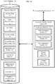
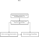
- FIG. 1 illustrates an example environment in which location determination is performed for an AR display device.
- the example environment disclosed herein includes a system for determining a user location in order to share content, such as virtual objects and other virtually displayed content whether shared, streamed, or generated locally.
- Augmented reality display device 101 presents an augmented reality view 102 to a user.
- AR comprises a view of some portion of a real world, with one or more virtual objects overlaid over that view, e.g. by projecting a virtual object onto a pair of AR glasses that reflect one or more displayed virtual objects into the eyes of the user, such that the virtual objects are placed in between the user and the real world.
- various devices and techniques can be used to make the virtual object appear within a specific location with respect to the real world.
- the depicted augmented reality display 101 could be used to display a gremlin riding waves on a surf board in the augmented reality display device view 102.
- Such a display might be facilitated by placing various sensors on the augmented reality display device 101, such as cameras on the left and right side of the glasses for stereo vision, an accelerometer, a magnetometer, and gyroscope for detection of movement and orientation. Further details regarding an exemplary augmented reality display device are described in U.S. Patent Application Publication No. 2015205126 .
- the augmented reality display device view 102 also includes a displayed verbose initialization process 103, which includes gathering metadata, identifying the map area, identifying a nearest keyframe and identifying orientation. This process will be discussed in more detail below. However, the process need not necessarily be shown to the users or in the alternative some portion/summary information thereof may be shown to users.
- An augmented reality system 110 provides modules and database elements for a localization process. These modules and database elements are implemented on a computing system such as that disclosed in FIG. 9 and the corresponding paragraphs herein.
- the modules and database elements themselves may comprise software, hardware, or some combination thereof.
- Such systems may be provided in a dedicated computing module that connects to the augmented reality display device 101 - either wired or wirelessly, as part of the augmented reality display device 101 itself, as part of another system or computing device that connects to the augmented reality display device 101 and is connected either via wires or wirelessly, or any combination thereof.
- the augmented reality system 110 initiates the localization process using an initialization module 111.
- the initialization module 111 may be used to make a determination as to whether the augmented reality display device 101 knows what area region/location the augmented reality display device 101 is in, whether the augmented reality display device 101 knows what keyframe is the closest keyframe, and whether the augmented reality display device 101 knows what orientation it is in with respect to an area region origin point.
- the initialization module 111 may trigger localization at the correct stage of the process, e.g. trigger area localization when the area is unknown or trigger coarse localization if the area is known but the orientation and closest keyframe is unknown.
- an area localization module e.g., area localization interface module 113.
- Localization interface modules 112 include an area localization interface module 113, a coarse localization interface module 114, and a fine localization interface module 115. Each module handles a different portion of the localization process in order to determine a current location and orientation with respect to an origin point for a particular area.
- the area localization interface module 113 gathers relevant area metadata such as wireless network devices within range using any network supported by the augmented reality system 110.
- Wireless networks may include short range networks such as Bluetooth, and longer range networks such as WiFi.
- other wireless networking standards may be use such as WiMAX, ZigBee, or cellular networks.
- one way networks may also provide relevant metadata such as digital or analog television signals, radio signals, or any other signals that are associated with an area.
- metadata may be organized in a map area dataset 131 and into an area metadata portion 132. Additionally, the map area data 131 may comprise a temporary or working map area.
- the map area data 131 may correspond to a yet unidentified/undefined map area.
- the metadata may be transmitted to an augmented reality content server 150 for a determination of a map area that best matches the identified metadata.
- the map area data that corresponds to the identified map area may be transmitted to the augmented reality system 110 to perform coarse localization and fine localization.
- the coarse localization process may be executed at the augmented reality content server 150 or a device associated thereof.
- the present illustration provides for performing coarse localization and fine localization at the augmented reality system 110.
- the map area data 131 when populated includes at least an area region/location definition (such as an area boundary and topology data), and a set of keyframes associated with that area.
- the coarse localization interface module 114 may receive the area region/location information and may store it appropriately, such as in the area region/location 133 within the local cache/database 130.
- the coarse localization interface module 114 may also receive keyframe information which may also be stored appropriately.
- the coarse localization interface module 114 may receive keyframes 134 and store the keyframes 134 within the local cache/database 130.
- the coarse localization interface module 114 may determine features 134a of the keyframes 134 and store the features 134a within the local cache/database 130. Examples of features include edges, corners, blobs, ridges, and the like.
- the coarse localization interface module 114 may then capture a keyframe (e.g., a keyframe of the keyframes 134) and compare the captured keyframe to a set of keyframes (e.g., keyframes 164) and/or features (e.g., features 164a) thereof received from the augmented reality content server 150 to identify the nearest and/or best matching keyframe.
- the coarse localization interface module 114 may compare the features 134a in the keyframes 134 to features 164a of keyframes 164 from a server database 160 of the augmented reality content server 150. However, the best matching keyframe may not always be the nearest keyframe.
- the nearest keyframe is situated such that it displays a view that is outside of the field of view of the augmented reality display device 101
- the keyframe captured using that augmented reality display device 101 will not find that the captured keyframe is similar to the nearest keyframe because the nearest keyframe captured is hidden from view.
- the keyframes may be captured with a 360 degree or similar camera, or some combination of cameras to capture a field of view greater than that visible by the user. Further details of the process of identifying the nearest or best matching keyframe will be discussed below. Further details regarding keyframe processing are described in U.S. Patent Application Publication No. 2015356782 titled "CREATING A TOPOLOGICAL MAP FOR LOCALIZATION IN AUGMENTED OR VIRTUAL REALITY SYSTEMS", filed May 7 2015.
- the fine locational interface module 115 can compare the matching keyframe to the keyframe captured using that augmented reality display device 101. Based on this comparison, the augmented reality system 110 can determine the pose (position and orientation) of the augmented reality display device 101. Determining the pose is generally performed in two steps. First, the relative pose is determined with respect to the keyframe. Second, the position of the augmented reality display device 101 with respect to a map area origin is determined. This can be accomplished by chaining two transforms: one from the map area origin to the keyframe and one from the keyframe to the augmented reality display device 101. Thus, the pose of the augmented reality display device 101 can be determined with respect to the map area origin.
- the relative position with respect to a keyframe can be translated to a relative position with respect to the map area origin, which enables a shared user experience in a given area because multiple augmented reality display device users may interact with the same virtual object(s) in the same location with respect to the shared map area origin point and physical space.
- the local cache/database 130 may comprise only non-volatile storage - e.g. solid state drives, hard disk drives, or any other persistent rewritable media or medium. However, the local cache/database 130 may also comprise only volatile storage - e.g. random access memory (RAM), or in the alternative may comprise some combination of volatile and nonvolatile storage. Furthermore, the local cache/database 130 may be divided into different regions such as a volatile memory used to hold the map area data 131 for a working or current region and a nonvolatile portion for storing map area data for the current or working map area that does not need to be accessed as frequently or for storing map area data for map areas previously accessed or marked, such as a home office, business conference room, or other locations.
- RAM random access memory
- the augmented reality content server 150 has at least localization modules 151 and the server database 160.
- the localization modules 151 largely mirror the localization interface modules 112. However, the localization modules 151 will be discussed in more detail in regard to FIG. 2A .
- the server database 160 is essentially the same as the local cache/database 130 with map area data 161 mirroring that of the map area data 131, area metadata 162 corresponding to the area metadata 132, area region/location 163 corresponding to the area region/location 133, keyframes 164 corresponding to the keyframes 134, and features 164a corresponding to the features 134a.
- the server database 160 may aggregate data from multiple sources not readily accessible by the augmented reality system 110 except through the augmented reality content server 150.
- the server database 160 may include metadata collected from other users, from other systems, and even from sources that are not augmented reality systems, e.g. mapping systems, and other data such as data that represents the physical location of different wireless networking devices, such as cell phone towers, WiFi hot spots, and broadcast media antennas.
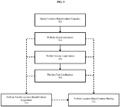
- FIGs. 2A-B illustrate an example augmented reality content server and an augmented reality system.
- FIG. 2A provides a more detailed view of the server side infrastructure
- FIG. 2B provides a more detailed view of an augmented reality device.
- FIG. 2A illustrates an example augmented reality content server 150 and server database 160.
- the augmented reality content server 150 and the server database 160 have been modified to illustrate data and modules for localization and content services.
- the augmented reality content server 150 the localization modules 151, the server database 160, the map area data 161, the area metadata 162, the area region/location 163, the keyframes 164, and the features 164a are described above in regard to FIG. 1 .
- one difference can be found within the localization modules 151, which have now been populated with an area localization module 152, a coarse localization module 153, and a fine localization module 154.
- the area localization module 152 may be used to select a match or best matching map area or region.
- the area localization module 152 may use metadata collected from a user device (e.g., the augmented reality display device 101), whether alone or in combination with coordinate information, to determine an area location.
- a user device e.g., the augmented reality display device 101
- the technique comprises gathering relevant metadata accessible or identifiable at an augmented reality device (e.g., the augmented reality display device 101), such as by gathering information pertaining to wireless networks that can be sensed at the augmented reality device, and comparing the metadata received/gathered by the augmented reality device with the area metadata 162 of a plurality of map area data sets (e.g., the map area data 161).
- the area localization module 152 may compare a set of received metadata to a plurality of sets of map area data each including or corresponding to a set of area metadata such as the map area data 161 to identify one or more map areas that matches or is the best match to the received/collected area metadata.
- map areas comprise an area region/location.
- a user's home may comprise one area where the boundary of that area is the same as their property boundary (e.g. parcel) and the area region/location may also be associated with an area wireframe 165 that is representative of the various walls, doors windows, of the home along with other relevant objects or physical features.
- some user devices may have previously provided keyframes to the augmented reality content server 150 which were previously stored as keyframes 164.
- the keyframes 164 themselves correspond to an image captured, usually a stereo image, at a known position and orientation.
- Features 164a associated with the keyframes 164 may be determined and stored. Examples of features include edges, corners, blobs, ridges, and the like.
- the keyframes 164 may be used as part of a process to perform coarse localization, by identifying a keyframe of the keyframes 164 associated with the identified area region that is the best match to an image taken at the augmented reality display device 101.
- the coarse localization may include capturing the keyframes 134, determining the features 134a in the keyframes 134 and comparing the features 134a in the keyframes 134 to the features 164a in the keyframes 164.
- the necessary processing to determine the best matching keyframe could be performed on the augmented reality system 110 when the keyframes 164 are already present on the device (such as keyframes associated with map area data 131 stored in the local cache/database 130), or if the keyframes 164 are sent to the augmented reality system 110.
- the augmented reality content server may perform the processing of the keyframes 164.
- the fine localization module 154 may be used as part of a process to determine the position and orientation of the augmented reality system 110 with respect to the map area origin. Generally, this may be completed in two steps. First, the relative position and orientation of the augmented reality system 110 may be determined relative to the matching keyframe. Second the position and orientation of the augmented reality system 110 may be determined by translating the relative position and orientation with respect to the matching keyframe to a position and orientation with respect to the map area origin. Furthermore, latency can be an issue when determining the pose of a user device because if the latency is too high the user may no longer be in the same or in a sufficiently similar pose.
- the processing capabilities of the augmented reality system 110 may be such that the latency in combination with the processing time at the augmented reality content server 150 is less than the processing time at the augmented reality system 110. Therefore, in some cases the fine localization may be executed at the augmented reality content server 150. Additionally, the execution may be predicated on a determination or other data indicating that the latency and processing time at the augmented reality content server 150 is less than the processing time at the augmented reality system 110.
- the augmented reality content server 150 may utilize information gathered to initiate additional content services. Such actions could be taken in order to facility content streaming and content sharing.
- the area localization module 152 may be used to trigger relevant transmission of applications and associated data from applications & data 170. For instance, the area localization module 152 may determine that the identified area region/location includes a local fitness center. As a result, an application for the fitness center or an application associated with fitness activities may be transmitted to the user device (e.g., the augmented reality display device 101), such that the user can begin using the application either upon completion of the transfer or immediately upon the completion of the determination of the user's position and orientation, or some combination thereof. In one use case, a user may be able to use an application to setup a reservation on one or more exercise machines and start a training session with a virtual trainer.
- the user device e.g., the augmented reality display device 101
- a content streaming module 156 may be used to manage the selection of the application and streaming of data from the server database 160, for example system/configuration data 172 for the user device and user data 171 associated with a particular user (e.g. status as a current member at GOLD'S GYM and application preferences) may be used to trigger automatic transmission of data before the users' position and orientation are determined.
- system/configuration data 172 for the user device and user data 171 associated with a particular user e.g. status as a current member at GOLD'S GYM and application preferences
- the area localization module 152 may be used to trigger relevant transmission of applications and associated data for content sharing.
- an application may be transmitted for facilitating a virtual group cycling class.
- users may participate in a group class where each user is displayed virtual objects associated with other users in the class, such that real objects (e.g. other participants) are augmented with the virtual objects, and the virtual objects are provided by or populated with data from the individual users transmitted either directly or from within a local network (e.g. facility WiFi network) in order to avoid incurring delay.
- a local network e.g. facility WiFi network
- individual participants could select or be assigned virtual logos and numbers for teams that are virtually applied to their physical clothing as virtual objects viewable only by those using augmented reality devices (e.g., the augmented reality display device 101).
- a content sharing module 155 may determine appropriate applications and data to provide from applications & data 170. Furthermore, a user list & data 168 for the map area data 161 may identify individual users present within the area, while virtual/physical object data 166 for that area may identify objects and their locations with respect to real world objects. Furthermore, the map area may be associated with an application list & associated data 167.
- the area wireframe 165 may provide a virtual representation of physical objects (e.g. walls, windows, railings, stairs, etc.). Wireframe data can be particularly useful for determining which virtual objects to display. For instance, a user in a conference room giving a presentation would normally expect that the presentation would be viewable only by the users in the same room. Using the wireframe information, the content sharing module 155 can determine whether a user is in the same conference room and restrict or block access to at least the virtual portions of the presentation by users that are not in the same room.
- wireframe data can be particularly useful for determining which virtual objects to display. For instance, a user in a conference room giving a presentation would normally expect that the presentation would be viewable only by the users in the same room.
- the content sharing module 155 can determine whether a user is in the same conference room and restrict or block access to at least the virtual portions of the presentation by users that are not in the same room.
- FIG. 2B illustrates an example augmented reality system 110 and local cache/database 130.
- the augmented reality system 110 and the local cache/database 130 has been modified to include additional data and modules and for operating the augmented reality system 110.
- initialization module 111 localization interface modules 112, area localization interface module 113, coarse localization module 114, and fine localization interface module 115 are as described previously.
- Content sharing interface module 121 provides the augmented reality display device 101 side functionality for content sharing from the augmented reality system 110.
- the content sharing interface module 121 can be used to share virtual objects with other users that are generated by the user or the user's augmented reality display device 101.
- a user's augmented reality display device 101 may have stored therein a presentation such as in user data 141, which the user's augmented reality display device 101 may provide directly or over a local network to other users.
- this may be performed by first determining which users are in a designated area using user list & data 138 and/or the user list & data 168, and second by setting up a connection between the user sharing the content and the user receiving the content such that the shared content can be transmitted directly to the user or via a local network, but without sending the shared content through an external server.
- some or all of the content sharing may be facilitated or transmitted and processed using the augmented reality content server 150.
- content that is manipulated locally or that is time sensitive would generally be shared locally by transmission from the content provider to the content receivers either directly or over a local network to avoid any delay caused by the augmented reality content server 150.
- Content streaming interface module 122 is similar to the content sharing interface module 121 except that the content streaming interface module 122 is provided to address content that does not originate from an augmented reality system 110.
- Content that originates elsewhere presents a different issue than that of content that originates from an augmented reality system 110.
- content provided by the augmented reality display device 101 would generally suffer an unnatural delay if it had to be transmitted to augmented reality content server 150 and then retransmitted to devices that are local to the content owner such as during a shared viewing.
- content that originates from elsewhere would suffer an unnatural delay if it was first transmitted to a particular augmented reality system 110 before then being retransmitted by that augmented reality system 110 to other user devices.
- the augmented reality content server 150 could be used to send the content to the respective devices such that all users receive such content at the same time or the augmented reality content server 150 or content streaming interface module 122 could be used to synchronize the play back at the respective devices, e.g. by using time stamps and adjustable delays.
- the local cache/database 130 largely mirrors that of the server database 160.
- the local cache/database 130 provides data management for the augmented reality system 110 and therefore may include some data not present in the server database 160.
- the local cache/database 130 may include temporary data maintained for ongoing tracking and other data that mirrors a portion of the server database 160, e.g. local copies of map area data in use or frequently used, data associated with a favorite/bookmarked location, or map area data 131 for previously accessed map areas.
- most of the data in local cache/database 130 corresponds to the data or a subset thereof of data on the server database 160.
- area metadata 132 corresponds to the area metadata 162
- area region/location 133 corresponds to the area region/location 163
- keyframes 134 correspond to the keyframes 164
- features 134a correspond to features 164a
- area wireframe 135 corresponds to the area wireframe 165
- virtual/physical object data 136 corresponds to the virtual/physical object data 166
- application list & data 137 corresponds to the application list & data 167
- user list & data 138 corresponds to the user list & data 168
- applications & data 140 corresponds to the applications & data 170
- user data 141 corresponds to the user data 171
- system/configuration data 142 corresponds to the system/configuration data 172.
- the augmented reality system 110 may include a display device controller 123 for interfacing with the augmented reality display device 101, a device sensor module 124 for monitoring and managing the sensors and the data they collect, and a user interface module 125 for providing for a user to interface and control the augmented reality display device 101.
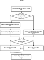
- FIG. 3 illustrates an example process flow for performing a localization process.
- the process operates by performing an identification of a map area, identification of a closest reference point, and determining a position and orientation using that reference point. Furthermore, during each phase in the process, certain steps may be taken to acquire content and to perform content sharing as appropriate.
- the process starts at 302 where the location determination sequence is initiated.
- the initiation could be triggered by any number of things.
- the location determination sequence may be triggered upon boot up, upon a determination that the augmented reality display device 101 does not know the map area that it is in, upon a determination that the augmented reality display device 101 does not know its position or orientation, upon the start of an application, upon initiation by a user, or any combination thereof.
- area localization is performed to determine which map area the augmented reality display device 101 is in. This process will be discussed further in regard to FIGs. 4A-C . However, briefly area localization is performed by gathering relevant metadata identifiable at the augmented reality display device 101 location, which is in turn compared to previously stored metadata (e.g. at the server database 160) to identify the area that best matches the collected data.
- coarse localization can be performed once the map area has been identified. Briefly, coarse localization is performed by first capturing a keyframe at the augmented reality display device 101 and identifying a keyframe (of a set of keyframes) associated with the map area that best matches the captured keyframe to be used in performing fine localization. The coarse localization process is described further in regard to FIG. 5 .
- Fine localization can be performed using many techniques, for example determining the relative position of the user with respect to the best matching keyframe, and then translating the users relative position to the best matching keyframe into a relative position with respect to a shared map area origin in order to provide for consistent and sharable virtual object positioning, e.g. virtual objects positioned at the same location for each user and persisting across multiple augmented reality sessions. This process is described further in regard to FIG. 6 .
- Parallel location based content acquisition can be performed at 310. This process may be triggered at any number of stages.
- the area localization process may trigger the transfer of an application associated with a shopping mall when the area localization process determines that the user is in an area that corresponds to a map area of a mall
- the coarse localization process may trigger the transfer of an application associated with a movie theater when an identified best matching keyframe is within a given distance from a movie theater ticket window
- the fine localization process may be used to trigger automatic transfer of a virtual menu application and ordering system for one or more nearby storefront.
- Parallel location based content sharing can be performed at 312. This process is similar to that of the content acquisition, but for content transmitted from users in the area.
- content sharing may be triggered at the level of an identified map area e.g. a street performer incorporating virtual objects in a public performance, content sharing may be triggered based on proximity to a best matching keyframe e.g. a movie theater transmitting virtual objects for a virtual quiz game to patrons waiting to enter the theater for a related movie, or based on an identified location e.g. the movie theater streaming special content to patrons that are identified to be within the movie theater itself and the content corresponding to the specific movie ticket held.
- a best matching keyframe e.g. a movie theater transmitting virtual objects for a virtual quiz game to patrons waiting to enter the theater for a related movie
- an identified location e.g. the movie theater streaming special content to patrons that are identified to be within the movie theater itself and the content corresponding to the specific movie ticket held.
- FIGs. 4A-C illustrate example process flows for the perform area localization step 304 illustrated in FIG. 3 .
- FIGs. 4A-C each illustrate one possible flow of three possible process flows for determining the map area by performing processing at an augmented reality system, an augmented reality content server, or some combination thereof. Furthermore, while illustrated separately, aspects of each flow may be performed in any of the other process flows as appropriate.
- FIG. 4A provides an illustration of an area localization process executed by gathering metadata and transmitting that metadata to an augmented reality content server for processing.
- Metadata may include any relevant identifiable data e.g. any identifiable WiFi network information, Bluetooth devices, radio stations, broadcast television, cellular towers, or any other information transmitted via wireless protocols. Additional metadata may be gathered such as the temperature, position of the sun, moon, quick response codes (QR codes), street sign information, or any other data retrievable via image processing.
- QR codes quick response codes
- the collected metadata is used to determine a corresponding map area location at 406A.
- This can be performed using any techniques of matching data to identify map areas with corresponding metadata stored at the augmented reality content server (e.g. the area metadata 162) and to narrow those map areas to identify the map area that best matches the received metadata.
- one set of metadata might include information corresponding to 10 WiFi networks, and in a first pass the map areas may be narrowed to include only map areas that are associated with at least one of the 10 WiFi network identified in the metadata, followed by further processing to determine the best matching map area using other or additional data.
- scores may be generated for each map area of a set of potential map areas that include at least some matching metadata, and the area with the highest score can be selected as the best matching map area.
- the metadata may be processed at 406A using heuristic methods and location information.
- GPS data could be collected from cellular devices and transmitted to the augmented reality system via peer-to-peer WiFi (such as APIPA or BONJOUR), broadcast universal datagram protocol, Bluetooth, or any other wireless device to device method.
- the GPS data or data associated with it can be analyzed to determine what level of accuracy the GPS data has (e.g. accurate to within 0.1 meters or to within 1.0 meter).
- the GPS data can then be combined with data representing the distance between the cellular device and the augmented reality system, e.g. within 1 to 5 meters of the cellular device.
- the location of the augmented reality display device can be found to within a region (e.g. between an inner and outer boundary).
- the augmented reality display device is within a 6-meter region surrounding the cellular device.
- This 6-meter region may be sufficiently accurate to identify the augmented reality display device as being within a specific map area but will be dependent on various factors, e.g. the map areas size and the location of the GPS coordinates being far enough away from a map area boundary.
- Additional GPS information can be used from other cellular devices in order help narrow down a range that the augmented reality device is located within, where the additional GPS information can be used to generate additional regions that the augmented reality display device may be located in, and where the augmented reality system is within the area of regions where all the regions overlap.
- WiFi hotspots could be mapped to specific areas and coordinates, e.g. a hotspot at a STARBUCKS could be presumed to be located within a structure that houses that particular STARBUCKS at some set of coordinates determined using map data.
- the GPS information for a device might first comprise location data that is captured quickly but that is not particularly accurate, e.g. coarse position information accurate to within 1 meter.
- the GPS data may be updated by a cellular device with more accurate location information, e.g. fine position information accurate to within 0.1 meters.
- GPS position information for cellular devices may not be sufficiently accurate initially to identify the corresponding map area but may become so over time.
- GPS information may be provided by any GPS enabled device that includes system/components for peer-to-peer transmission of the data between that device and the augmented reality system.
- the heuristic method could be combined with the metadata matching techniques describe above, such as for preprocessing data in order to narrow the potential map areas or to select between map areas with otherwise similar data.
- the distance between the augmented reality display device may be predetermined, such as based on a communications protocol. For example, different maximum distances could be associated with different versions of the Bluetooth communications protocol, and those protocols could also be associated with a default minimum distance (e.g. zero meters).
- the minimum and maximum distances could be determined based on signal strength information.
- WiFi communications protocols are commonly associated with differing signal strengths for transmission, and different characteristics for absorption by materials in the environment. Therefore, using information collected at the augmented reality system, computations can be performed to estimate the distance from the transmitting device. Such information could be analyzed using default or simple models that are always applied in the same way regardless of environment characteristics. However, the calculations could take into account things like emissivity of walls, ambient air temperature, humidity, and the like. In this way, the augmented reality system can estimate the minimum distance and the maximum distance the augmented reality system is from a transmitting device based on at least the signal strength.
- the augmented reality content server can transmit new/updated map area data to the users augmented reality system at 408A including any data corresponding to the area metadata 132, the area region/location 133, the keyframes 134, the area wireframe 135, the virtual/physical object data 136, and the user list & data 138.
- various thresholds or conditions can be implemented for use in updating map area metadata such that metadata for any given map area is not updated solely as a result of a single occurrence of a particular piece of metadata, but as a result of some number of occurrences possibly over a minimum amount of time and/or from a minimum number of users or devices.
- process at 406A and/or 408A may trigger the initiation of parallel location based content processes 410A for the identified map area as discussed above in regard to content acquisition 310 and content sharing 312.
- FIG. 4B provides an illustration of an area localization process executed by gathering metadata and transmitting that metadata to an augmented reality content server for processing while also processing the same metadata at the augmented reality system.
- the process starts at 402B where metadata is gathered at a physical location of the augmented reality system as discussed above in regard to 402A.
- the present illustration includes a determination at 403B as to whether the collected metadata includes metadata that corresponds to a map area that is stored at the augmented reality system 110, e.g. a map area stored in the local cache/database 130 at area metadata 132. If the metadata corresponds to locally stored metadata then the process proceeds with a local determination of the map area at 405B and a remote determination of the map area at 404B and 406B. Otherwise the process proceeds only with a remote determination of the map area, e.g. at augmented reality content server 150.
- Transmitting metadata information to a data service at 404B is essentially the same as that discussed above with regard to 404A.
- determining corresponding map area location(s) at 406B is essentially equivalent to that discussed in 406A.
- determining a corresponding map area location using local database/cache at 405B is also essentially the same as 406A except to the extent that 405B operates using a local dataset instead of the dataset stored at the augmented reality content server 150.
- the process determines whether there is a map area conflict, e.g. the map area identified at the augmented reality display device is not the same as the map area identified at the remote server.
- This could be performed at the augmented reality display device, augmented reality system 110, or at the remote device, augmented reality content server 150.
- This can be performed using any number of techniques, e.g. comparing map area IDs, comparing map area regions/boundaries, comparing map area origins, comparing some or all map area data, or any combination thereof.
- the process may skip the determination at 407B and proceed directly to 408B where the augmented reality display device receives new or updated map area data as describe in regard to 408A.
- process proceeds to 409B where the conflict is resolved.
- This is essentially a limited form of the process described above in regard to 406A where the map area identified at the augmented reality display device and the map area identified at the remote system are both evaluated to determine which is the better match.
- This can be performed at either the local or the remote device.
- the present illustration presumes that this will occur at the remote device because the remote device includes the full set of map data, whereas the augmented reality display device includes a limited set of map data that may not be as up to date as that on the remote device.
- the process could be performed at the augmented reality display device provided that the augmented reality device includes or is provided the appropriate data to be able to perform a reliable determination.
- process may initiate at 410B parallel location based content processes similar to those discussed above regarding 410A.
- FIG. 4C provides an illustration of an area localization process executed by first processing gathered metadata at the augmented reality system when the metadata corresponds to a stored map area and subsequently processing the metadata at the augmented reality content server when the identified map area is below a given threshold level of confidence.
- the present figure includes a number of steps that correspond to those of FIGs. 4A and 4B .
- 402C corresponds to 402A
- 404C corresponds to 404A
- 406C corresponds to 406A
- 408C corresponds to 408A
- 410C corresponds to 410A.
- 403C is similar to 403B except to the extent that when the augmented reality display device includes one or more map areas associated with metadata that matches at least some of the metadata gathered at the augmented reality display device, only a local determination is made as to which map area is the best match. A score is then calculated to determine if that match is deemed to have a sufficient level of confidence. When there is no matching stored metadata or when the confidence level is below a specified threshold, the process proceeds at 404C.
- the process continues at 405C by determining a corresponding map area using the local database/cache 130 as discussed in 405B. Subsequently a confidence level is calculated for the map area at 407C.
- the confidence level may be calculated using any appropriate techniques, e.g. determining an amount of metadata associated with the map area that is a match to the corresponding map area, computing the amount of metadata that does not have a corresponding match, implementing weights for different types of data, or any combination thereof.
- the process may proceed to 410C, otherwise the process proceeds through 404C, 406C, and 408C at the augmented reality content server to determine the best matching map area.
- weights and confidence thresholds may be used to determine the best matching map areas.
- the disclosed techniques may be used to enforce minimum confidence thresholds such as for a determination as to whether a best matching map area has sufficient similarity to be used as a matching map area. For instance, if no map area is found that includes any matching metadata or if only a small portion of metadata is found but that metadata matches multiple map areas, the location may be found to have insufficient information with which to identify any particular map area as a matching map area.
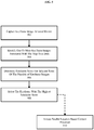
- FIG. 5 illustrates an example process flow for the "perform coarse localization" step illustrated in FIG. 3 .
- This process generally includes capturing a keyframe at a local device (e.g., the augmented reality display device) and comparing that keyframe to a set of previously captured keyframes to determine the nearest or best matching keyframe. As illustrated, the process is executed on the augmented reality content server.
- the local device augmented reality system 110
- processing the keyframes at the local device may necessitate transfer of the one or more keyframes to the local device, such as when additional keyframes are available or the keyframe data is out of date.
- a keyframe is captured at the local device.
- a keyframe may be captured using an apparatus attached to or integrated in the augmented reality display device and controlled using a device sensor module 124.
- the apparatus could include a single camera, dual cameras for stereo vision, a 360-degree camera, or some combination thereof.
- the captured image(s) have a known/fixed position relative to that of the users.
- the keyframes may be stored as part of a map area data set such as illustrated in map area data 131 and 161 which include keyframes 134 and 164, respectively, and the features 134a and 164a, respectively.
- the keyframes and features may be stored in any manner, such as via a keyframe/features database where individual keyframes and associated features are identified with one or more identifiers, e.g. based on a map area ID, a unique identification key generated based on any data, based on the position/location information associated with those keyframes, or any combination thereof.
- the features 134a and 164a in the keyframes 134 and 164, respectively, may be determined.
- the keyframe captured at the local device is compared to the one or more keyframes identified at 504 to generate a similarity score for each keyframe.
- This process may be performed using any appropriate technique.
- the features 134a in the keyframes 134 are compared to the features 164a of the keyframes 164.
- the similarity score for the keyframe 134 is based on the features 134a and the features 164a.
- the keyframe with the best similarity score is selected, which may be used to trigger parallel location based content processes 510 for the identified keyframe as discussed above in regard to content acquisition 310 and content sharing 312.
- FIG. 6 illustrates an example process flow for the "perform fine localization" step illustrated in FIG. 3 .
- the captured keyframe is compared to the best matching keyframe. This process may be performed using any appropriate technique in order to determine the devices pose with respect to the best matching keyframe.
- the pose of the local device can be determined using the position of the best matching keyframe with respect to the map area origin and the relative position of the local device with respect to that keyframe.
- the position of the augmented reality device with respect to the map area origin may be determined using the relative pose with respect to the keyframe and the keyframes pose with respect to the map area origin. This can be accomplished by chaining two transforms: one from the map area origin to the keyframe and one from the keyframe to the local device.
- the pose of the local device can be determined with respect to the map area origin. Therefore, to determine the map area origin of the local device (e.g., augmented reality display device 101), the relative position with respect to a keyframe can be translated to a relative position with respect to the map area origin.
- location based services that depend on a known position can be initiated. For instance, at 610 location based content acquisition can be performed based on the local device position and orientation, e.g. pulling reservation schedule data and a reservation application from the augmented reality content server 150 for one or more restaurants in view. In another example of location based services, at 612 location based content sharing may be initiated based on a determination that another user in the area is sharing content, e.g. joining a meeting that includes virtual objects as part of a discussion or presentation.
- FIGs. 7A-J provide an illustrative example of a localization process for a user at an undetermined location.
- the augmented reality display device may presume that the current location is the last known location in order to facilitate retrieval of potentially relevant data or display virtual objects previously within view or within an accessible region of the augmented reality display device.
- the location and specific positioning information must be either confirmed or determined. Regardless, the present example presumes no default position/location information.
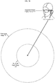
- FIG. 7A illustrates an augmented reality display device 701 (e.g., the augmented reality display device 101) worn by a user at a user location 702 that is undetermined/unidentified by the augmented reality system 110.
- a location may be undetermined/unidentified due to any number of reasons, e.g. the augmented reality display device 701 was just booted/rebooted, sensor data has become corrupted, wireless signals may have been lost, etc. Thus, triggering the need for the augmented reality display device 701 to perform localization.
- FIG. 7B illustrates relative ranges of two different communication protocols with respect to the user location 702.
- a first range which is the shorter of the two is the Bluetooth signal range 720.
- a second range which is the longer of the two is the WiFi signal range 710.
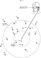
- FIG. 7C illustrates the addition of various WiFi networks that may or may not be identifiable by the augmented reality display device 701.
- the WiFi signals within the WiFi signal range 710 may be detected by the by the augmented reality display device 701, while 710a-b, 710e, 710n and 710s are too distant from the augmented reality display device 701 to be detected.
- the augmented reality display device 701 may collect metadata corresponding to these WiFi networks for use in determining the correct map area location.
- FIG. 7D illustrates the addition of various Bluetooth networks proximately located with respect to the user location 702. Similar to the WiFi networked discussed previously, metadata may be gathered pertaining to the network/devices within the range of detection 720. Here this includes 720h, 7201, and 720m, while 720a-g, 720i-k, and 720n-s are undetectable.
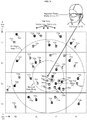
- FIG. 7E illustrates an overlay of a set of map areas.
- the map areas 705(X0, Y0) - 705(X3, Y3) are illustrated as a set of square regions identified here by their positions on an X axis 704 and Y axis 703.
- These map areas may be identified by matching the metadata collected to metadata previously stored in a location associated with the respective map areas, e.g. map areas that are known to be associated with one or more identified WiFi networks and Bluetooth devices.
- the regions may have any shape and may be identified in any way as discussed previously and are merely shown in this way for ease of illustration.
- the location of the augmented reality display device 701 with respect to the map areas would not be known by an augmented reality system (e.g., the augmented reality system 110) or an augment reality content server (e.g., the augmented reality content server 150) during this part of the process, however for the sake of continuity, the user location and the map areas are shown in their actual positions.
- an augmented reality system e.g., the augmented reality system 110
- an augment reality content server e.g., the augmented reality content server 150
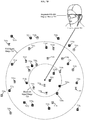
- FIG. 7F illustrates the determination of the map area that is the best matching map area. This can be performed as discussed above, where the metadata collected at the augmented reality system may be compared to previously stored metadata collected at known locations to identify a best matching map area. For instance, the map area that includes the most matching metadata to the metadata collected can be selected as the map area that the device is in. Here, the map area 705(X2, Y1) has been identified as the best matching map area.
- FIG. 7G illustrates a set of keyframes take at known locations from within the best matching map area.
- the keyframes 706a-e may be dispersed randomly across the map area 705(X2, Y1) as illustrated here.
- other techniques may be used to collect keyframes such as triggering the capture of a keyframe whenever a user is in or near a desired location for capture or through a setup process.
- the keyframes themselves are processed as previously discussed to determine a best matching or closest keyframe.
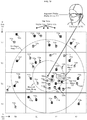
- FIG. 7H illustrates the selection of the best matching keyframe with respect to the captured keyframe.
- keyframe 706a is determined to be the most similar to the keyframe captured at the user device.
- the relative position of the augmented reality display device 701 may be determined with respect to the keyframe, and finally the relative position of the augmented reality display device 701 can be translated with respect to a map area origin 707 illustrated in FIG. 7I .
- FIG. 7J illustrates an example virtual object 708 displayed relative to the map area origin 707 in response to the determination of the location of the augmented reality display device 701.
- This virtual object 708 would be displayed in the same position and orientation for all users and therefore facilitate shared experiences.
- one user might point towards the virtual sign and another user might naturally look in that direction and be able to ascertain that the user is pointing to the virtual sign, or alternatively the user might have already seen the sign and understand that is what the user is pointing towards.
- FIGs. 8A-D provide an illustrative example of an area localization process for a user at an undetermined location, according to the invention.
- the illustration provides an approach that may be performed separately as an alternative to, or in combination with, the process illustrated in FIGs. 7A-J .
- FIGs. 8A-D illustrate a location based heuristic method of determining the map area that an augmented reality display device is in.
- FIG. 8A includes map areas 805(X0, Y0) - 805(X3, Y3) illustrated as a set of square regions identified here by their positions on an X axis 804 and Y axis 803. These are essentially equivalent to the previous illustration for map areas 705(X0, Y0) - 705(X3, Y3) and X axis 704 and Y axis 703.
- augmented reality display device 801 is equivalent to the augmented reality display device 701
- user location 802 is equivalent to the user location 702.
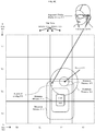
- FIG. 8B illustrates the addition of a Wireless signal originating within a known boundary.
- cafe 810 is representative of a known location with a known boundary from which the signal originates. Based on at least metadata associated with the signal a minimum and maximum distance from the boundary of cafe 810 is identified. The minimum distance is illustrated as rectangular element with rounded corners 811, while the maximum distance is illustrated as rectangular element with rounded corners 812.
- a signal might include a WiFi hotspot, WiMAX access point, or any other appropriate wireless communication protocol.
- the region represented by the space between 811 and 812 represents the possible locations in which the augmented reality display device 801 may be located. As illustrated, this includes six map areas - (X1, Y0), (X2, Y0), (X3, Y0), (X1, Y1), (X2, Y1), and (X3, Y1) - but none of the six can be identified reliably as the matching map area without additional information.
- the additional information might be collected based on the metadata matching processed discussed above, in which the metadata collected is used to determine which of the six map areas is the correct area.
- FIG. 8C illustrates the addition of new location data generated as a result of device 820.
- Device 820 might include a GPS mapping device, a cellular device, a cellular device with GPS or assisted GPS, or any other device with a wireless communication protocol that can exchange GPS data with an augmented reality system (e.g., the augmented reality system 110).
- an augmented reality system e.g., the augmented reality system 110.
- Associated with the device 820 is a minimum distance 821 and a maximum distance 822 both illustrated as circular boundaries in which the augmented reality system might be located.
- the information collected as a result of communication with the device 820 would suggest that the augmented reality display device 801 is located in one of four map areas - (X2, Y1), (X3, Y1), (X2, Y2), and (X3, Y2) - as indicated by the area bounded by 821 and 822.
- this information can be combined with the other information already collected which indicates that the augmented reality system should be located in the region of overlap 850, where the area bounded by 811 and 812 overlaps with the area bounded by 821 and 822.
- Based on this information it can be determined that the augmented reality system is located in either map area (X2, Y1) or map area (X3, Y1).
- this information might be combined with additional metadata via the metadata matching process discussed above to determine which of the two map areas is the correct map area.
- FIG. 8D illustrates another device providing information that can be used to identify a minimum and maximum distance from a measured point.
- device 830 has been identified, and has provided location information used to determine the minimum distance 831 from its measured location and the maximum distance 832 from its measured location.
- location information used to determine the minimum distance 831 from its measured location and the maximum distance 832 from its measured location.
- additional data such as illustrated in the metadata matching process of FIGs. 7A-J may be used to assist in determining the correct map area.
- the location based heuristic information may be incomplete or the metadata collected may be insufficient to determine the correct map area the augmented reality system is located in after one or more sets (e.g. regions in which the augmented reality system is located) of location data is collected.
- any data collected may be analyzed in any order, including analyzing the data as it is received, such that as soon as any combination of information is received that is sufficient to determine the correct map area the process may be completed and coarse and fine localization processes may be completed.
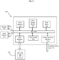
- FIG. 9 shows an architecture of an example computing system with which the disclosure may be implemented.
- the augmented reality content server 150 may include or comprise one or more similar systems to computer system 900 illustrated in FIG. 9 , linked together to service requests from any number of augmented reality systems.
- the augmented reality system 110 may also correspond to a computer system like the computer system 900.
- the modules of the augmented reality content server 150 and the augmented reality system 110 may be implemented as either hardware, software or some combination thereof as part of computer system 900.
- Computer system 900 includes a bus 906 or other communication mechanism for communicating information, which interconnects subsystems and devices, such as processor(s) 907, system memory 908 (e.g., RAM), static storage device 909 (e.g., ROM), disk drive 910 (e.g., magnetic or optical), data interface 933 (e.g., database connection), communication interface 914 (e.g., modem or Ethernet card), display 911 (e.g., CRT or LCD), input device 912 (e.g., keyboard and cursor control).
- processor(s) 907 system memory 908 (e.g., RAM), static storage device 909 (e.g., ROM), disk drive 910 (e.g., magnetic or optical), data interface 933 (e.g., database connection), communication interface 914 (e.g., modem or Ethernet card), display 911 (e.g., CRT or LCD), input device 912 (e.g., keyboard and cursor control).
- system memory 908 e.g., RAM
- computer system 900 performs specific operations by processor(s) 907 executing one or more sequences of one or more instructions contained in system memory 908. Such instructions may be read into system memory 908 from another computer readable/usable medium, such as static storage device 909 or disk drive 910.
- hard-wired circuitry may be used in place of or in combination with software instructions to implement the disclosure.
- embodiments of the disclosure are not limited to any specific combination of hardware circuitry and/or software.
- the term "logic" shall mean any combination of software or hardware that is used to implement all or part of the disclosure.
- Non-volatile media includes, for example, optical or magnetic disks, such as disk drive 910.
- Volatile media includes dynamic memory, such as system memory 908.
- Computer readable media include, for example, floppy disk, flexible disk, hard disk, magnetic tape, any other magnetic medium, CD-ROM, any other optical medium, punch cards, paper tape, any other physical medium with patterns of holes, RAM, PROM, EPROM, FLASH-EPROM (e.g., NAND flash, NOR flash), any other memory chip or cartridge, or any other medium from which a computer can read.
- execution of the sequences of instructions to practice the disclosure is performed by a single computer system 900.
- Two or more computer systems 900 coupled by communication link 915 may perform the sequence of instructions required to practice the disclosure in coordination with one another.
- Computer system 900 may transmit and receive messages, data, and instructions, including program, i.e., application code, through communication link 915 and communication interface 914.
- Received program code may be executed by processor 907 as it is received, and/or stored in disk drive 910, or other non-volatile storage for later execution.
- Database 932 in storage medium 931 may be used to store data accessible by system 900 via data interface 933.
Landscapes
- Engineering & Computer Science (AREA)
- Theoretical Computer Science (AREA)
- General Engineering & Computer Science (AREA)
- Databases & Information Systems (AREA)
- Physics & Mathematics (AREA)
- General Physics & Mathematics (AREA)
- Computer Networks & Wireless Communication (AREA)
- Signal Processing (AREA)
- Data Mining & Analysis (AREA)
- Human Computer Interaction (AREA)
- Remote Sensing (AREA)
- Library & Information Science (AREA)
- Software Systems (AREA)
- Computer Hardware Design (AREA)
- Computer Graphics (AREA)
- Computer Vision & Pattern Recognition (AREA)
- Processing Or Creating Images (AREA)
- User Interface Of Digital Computer (AREA)
- Position Fixing By Use Of Radio Waves (AREA)
- Telephonic Communication Services (AREA)
- Testing, Inspecting, Measuring Of Stereoscopic Televisions And Televisions (AREA)
- Mobile Radio Communication Systems (AREA)
- Image Analysis (AREA)
- Controls And Circuits For Display Device (AREA)
- Navigation (AREA)
Description
- The present disclosure generally relates to a computer implemented method for localization determination for information persistence and location based content sharing of interactive virtual or augmented reality environments for one or more users.
- Augmented reality (AR) environments are generated by computers using, in part, data that describes the environment. This data may describe various objects (both virtual and physical) a user may sense and interact with. Examples of these objects include objects that are rendered and displayed for a user to see, audio that is played for a user to hear, and tactile (or haptic) feedback for a user to feel. Users may sense and interact with these AR environments through a variety of visual, auditory, and tactile methods.
- Virtual reality (VR) or AR systems may be useful for many applications, spanning the fields of scientific visualization, medical training, military training, engineering design and prototyping, tele-manipulation and tele-presence, and personal entertainment to name a few. AR, in contrast to VR, comprises one or more virtual objects in relation to real objects of the physical world, e.g. virtual objects are positioned in relations to real objects of the physical world. This enhances the user's experience and enjoyment with AR devices and opens the door for a variety of applications that allow the user to experience real objects and virtual objects simultaneously.
-
US 2014/0323148 A1 andUS 2015/0310310 A1 disclose a computer implemented method for determining position and orientation information of an augmented reality display device, according to the preamble ofclaim 1. - However, there are significant challenges in providing an AR system. One preliminary challenge is how to determine the location of the user and device to a sufficient level of accuracy without requiring additional devices or hardware specifically directed towards addressing that problem, such as location beacons and/or GPS devices which add cost to the device and increase the overall size and power requirements.
- Thus, there is a need for improved systems and methods for localization determination to provide location based content sharing of interactive AR environments for one or more users.
- The invention is directed to a computer implemented method for determining position and orientation information of an augmented reality display device, according to
claim 1. - Embodiments of the invention are according to dependent claims 2-12.
- The drawings illustrate the design and utility of various embodiments of the present disclosure. It should be noted that the figures are not drawn to scale and that elements of similar structures or functions are represented by like reference numerals throughout the figures. In order to better appreciate how to obtain the above-recited and other advantages and objects of various embodiments of the disclosure, a more detailed description of the present disclosure briefly described above will be rendered by reference to specific embodiments thereof, which are illustrated in the accompanying drawings. Understanding that these drawings depict only typical embodiments of the disclosure and are not therefore to be considered limiting of its scope, the disclosure will be described and explained with additional specificity and detail through the use of the accompanying drawings in which:
- Figure (
FIG.) 1 illustrates an example environment in which location determination is performed for an augmented reality display device. -
FIGs. 2A-B illustrate an example augmented reality content server and an augmented reality system. -
FIG. 3 illustrates an example process flow for performing a localization process. -
FIGs. 4A-C illustrate example process flows for the "perform area localization" step illustrated inFIG. 3 . -
FIG. 5 illustrates an example process flow for the "perform coarse localization" step illustrated inFIG. 3 . -
FIG. 6 illustrates an example process flow for the "perform fine localization" step illustrated inFIG. 3 . -
FIGs. 7A-J provide an illustrative example of a localization process for a user at an undetermined location. -
FIGs. 8A-D provide an illustrative example of an area localization process for a user at an undetermined location, according to the invention. -
FIG. 9 shows an architecture of an example computing system with which the disclosure may be implemented. - Examples and embodiments of the present disclosure are directed to improved devices, systems and methods for localization determination for location based content sharing of interactive virtual reality (VR) or augmented reality (AR) environments for one or more users.
- Examples and embodiments illustrated herein provide processes and systems for determining the location of a user to provide for location based content sharing such as interacting with one or more virtual objects that other users in the same area are also able to interact with.
-
FIG. 1 illustrates an example environment in which location determination is performed for an AR display device. The example environment disclosed herein includes a system for determining a user location in order to share content, such as virtual objects and other virtually displayed content whether shared, streamed, or generated locally. - Augmented
reality display device 101 presents anaugmented reality view 102 to a user. Generally, AR comprises a view of some portion of a real world, with one or more virtual objects overlaid over that view, e.g. by projecting a virtual object onto a pair of AR glasses that reflect one or more displayed virtual objects into the eyes of the user, such that the virtual objects are placed in between the user and the real world. Furthermore, various devices and techniques can be used to make the virtual object appear within a specific location with respect to the real world. For instance, the depictedaugmented reality display 101 could be used to display a gremlin riding waves on a surf board in the augmented realitydisplay device view 102. Such a display might be facilitated by placing various sensors on the augmentedreality display device 101, such as cameras on the left and right side of the glasses for stereo vision, an accelerometer, a magnetometer, and gyroscope for detection of movement and orientation. Further details regarding an exemplary augmented reality display device are described inU.S. Patent Application Publication No. 2015205126 . - The augmented reality
display device view 102 also includes a displayedverbose initialization process 103, which includes gathering metadata, identifying the map area, identifying a nearest keyframe and identifying orientation. This process will be discussed in more detail below. However, the process need not necessarily be shown to the users or in the alternative some portion/summary information thereof may be shown to users. - An
augmented reality system 110 provides modules and database elements for a localization process. These modules and database elements are implemented on a computing system such as that disclosed inFIG. 9 and the corresponding paragraphs herein. The modules and database elements themselves may comprise software, hardware, or some combination thereof. Such systems may be provided in a dedicated computing module that connects to the augmented reality display device 101 - either wired or wirelessly, as part of the augmentedreality display device 101 itself, as part of another system or computing device that connects to the augmentedreality display device 101 and is connected either via wires or wirelessly, or any combination thereof. - The
augmented reality system 110 initiates the localization process using aninitialization module 111. For instance, theinitialization module 111 may be used to make a determination as to whether the augmentedreality display device 101 knows what area region/location the augmentedreality display device 101 is in, whether the augmentedreality display device 101 knows what keyframe is the closest keyframe, and whether the augmentedreality display device 101 knows what orientation it is in with respect to an area region origin point. As a result, theinitialization module 111 may trigger localization at the correct stage of the process, e.g. trigger area localization when the area is unknown or trigger coarse localization if the area is known but the orientation and closest keyframe is unknown. However, under most circumstances the augmentedreality display device 101 will start the localization process with an area localization module (e.g., area localization interface module 113). -
Localization interface modules 112 include an arealocalization interface module 113, a coarselocalization interface module 114, and a finelocalization interface module 115. Each module handles a different portion of the localization process in order to determine a current location and orientation with respect to an origin point for a particular area. - The area
localization interface module 113 gathers relevant area metadata such as wireless network devices within range using any network supported by theaugmented reality system 110. Wireless networks may include short range networks such as Bluetooth, and longer range networks such as WiFi. Furthermore, other wireless networking standards may be use such as WiMAX, ZigBee, or cellular networks. Furthermore, one way networks may also provide relevant metadata such as digital or analog television signals, radio signals, or any other signals that are associated with an area. During or after metadata is gathered it may be stored locally in an appropriate storage location, e.g. temporary memory or in a local cache/database 130. The metadata may be organized in amap area dataset 131 and into anarea metadata portion 132. Additionally, themap area data 131 may comprise a temporary or working map area. For example themap area data 131 may correspond to a yet unidentified/undefined map area. Finally, the metadata may be transmitted to an augmentedreality content server 150 for a determination of a map area that best matches the identified metadata. The map area data that corresponds to the identified map area may be transmitted to theaugmented reality system 110 to perform coarse localization and fine localization. The coarse localization process may be executed at the augmentedreality content server 150 or a device associated thereof. However, the present illustration provides for performing coarse localization and fine localization at theaugmented reality system 110. Themap area data 131 when populated includes at least an area region/location definition (such as an area boundary and topology data), and a set of keyframes associated with that area. - The coarse
localization interface module 114 may receive the area region/location information and may store it appropriately, such as in the area region/location 133 within the local cache/database 130. The coarselocalization interface module 114 may also receive keyframe information which may also be stored appropriately. For example, the coarselocalization interface module 114 may receivekeyframes 134 and store thekeyframes 134 within the local cache/database 130. The coarselocalization interface module 114 may determinefeatures 134a of thekeyframes 134 and store thefeatures 134a within the local cache/database 130. Examples of features include edges, corners, blobs, ridges, and the like. The coarselocalization interface module 114 may then capture a keyframe (e.g., a keyframe of the keyframes 134) and compare the captured keyframe to a set of keyframes (e.g., keyframes 164) and/or features (e.g., features 164a) thereof received from the augmentedreality content server 150 to identify the nearest and/or best matching keyframe. The coarselocalization interface module 114 may compare thefeatures 134a in thekeyframes 134 tofeatures 164a ofkeyframes 164 from aserver database 160 of the augmentedreality content server 150. However, the best matching keyframe may not always be the nearest keyframe. For example, if the nearest keyframe is situated such that it displays a view that is outside of the field of view of the augmentedreality display device 101, then the keyframe captured using that augmentedreality display device 101 will not find that the captured keyframe is similar to the nearest keyframe because the nearest keyframe captured is hidden from view. The keyframes may be captured with a 360 degree or similar camera, or some combination of cameras to capture a field of view greater than that visible by the user. Further details of the process of identifying the nearest or best matching keyframe will be discussed below. Further details regarding keyframe processing are described inU.S. Patent Application Publication No. 2015356782 titled "CREATING A TOPOLOGICAL MAP FOR LOCALIZATION IN AUGMENTED OR VIRTUAL REALITY SYSTEMS", filed May 7 2015. - Once a nearest or best matching keyframe (herein matching keyframe) has been determined, then the fine
locational interface module 115 can compare the matching keyframe to the keyframe captured using that augmentedreality display device 101. Based on this comparison, theaugmented reality system 110 can determine the pose (position and orientation) of the augmentedreality display device 101. Determining the pose is generally performed in two steps. First, the relative pose is determined with respect to the keyframe. Second, the position of the augmentedreality display device 101 with respect to a map area origin is determined. This can be accomplished by chaining two transforms: one from the map area origin to the keyframe and one from the keyframe to the augmentedreality display device 101. Thus, the pose of the augmentedreality display device 101 can be determined with respect to the map area origin. Therefore, to determine the map area origin of the augmentedreality display device 101, the relative position with respect to a keyframe can be translated to a relative position with respect to the map area origin, which enables a shared user experience in a given area because multiple augmented reality display device users may interact with the same virtual object(s) in the same location with respect to the shared map area origin point and physical space. - The local cache/
database 130 may comprise only non-volatile storage - e.g. solid state drives, hard disk drives, or any other persistent rewritable media or medium. However, the local cache/database 130 may also comprise only volatile storage - e.g. random access memory (RAM), or in the alternative may comprise some combination of volatile and nonvolatile storage. Furthermore, the local cache/database 130 may be divided into different regions such as a volatile memory used to hold themap area data 131 for a working or current region and a nonvolatile portion for storing map area data for the current or working map area that does not need to be accessed as frequently or for storing map area data for map areas previously accessed or marked, such as a home office, business conference room, or other locations. - The augmented
reality content server 150 has atleast localization modules 151 and theserver database 160. Thelocalization modules 151 largely mirror thelocalization interface modules 112. However, thelocalization modules 151 will be discussed in more detail in regard toFIG. 2A . - The
server database 160 is essentially the same as the local cache/database 130 withmap area data 161 mirroring that of themap area data 131,area metadata 162 corresponding to thearea metadata 132, area region/location 163 corresponding to the area region/location 133,keyframes 164 corresponding to thekeyframes 134, and features 164a corresponding to thefeatures 134a. However, theserver database 160 may aggregate data from multiple sources not readily accessible by theaugmented reality system 110 except through the augmentedreality content server 150. For instance, theserver database 160 may include metadata collected from other users, from other systems, and even from sources that are not augmented reality systems, e.g. mapping systems, and other data such as data that represents the physical location of different wireless networking devices, such as cell phone towers, WiFi hot spots, and broadcast media antennas. -
FIGs. 2A-B illustrate an example augmented reality content server and an augmented reality system.FIG. 2A provides a more detailed view of the server side infrastructure, whileFIG. 2B provides a more detailed view of an augmented reality device. -
FIG. 2A illustrates an example augmentedreality content server 150 andserver database 160. In addition to elements illustrated inFIG. 1 , the augmentedreality content server 150 and theserver database 160 have been modified to illustrate data and modules for localization and content services. - Items with the same reference number are the same as describe in regard to
FIG. 1 except to the extent that they are described differently here. Specifically, the augmentedreality content server 150, thelocalization modules 151, theserver database 160, themap area data 161, thearea metadata 162, the area region/location 163, thekeyframes 164, and thefeatures 164a are described above in regard toFIG. 1 . However, one difference can be found within thelocalization modules 151, which have now been populated with anarea localization module 152, acoarse localization module 153, and a fine localization module 154. - The
area localization module 152 may be used to select a match or best matching map area or region. Thearea localization module 152 may use metadata collected from a user device (e.g., the augmented reality display device 101), whether alone or in combination with coordinate information, to determine an area location. Such techniques will be discussed with regard to at leastFIGs. 3-7J . However, briefly the technique comprises gathering relevant metadata accessible or identifiable at an augmented reality device (e.g., the augmented reality display device 101), such as by gathering information pertaining to wireless networks that can be sensed at the augmented reality device, and comparing the metadata received/gathered by the augmented reality device with thearea metadata 162 of a plurality of map area data sets (e.g., the map area data 161). For example, thearea localization module 152 may compare a set of received metadata to a plurality of sets of map area data each including or corresponding to a set of area metadata such as themap area data 161 to identify one or more map areas that matches or is the best match to the received/collected area metadata. - The
coarse localization module 153 can be used to identify a best matching keyframe once a particular map area has been identified. As a general matter, map areas comprise an area region/location. For example, a user's home may comprise one area where the boundary of that area is the same as their property boundary (e.g. parcel) and the area region/location may also be associated with anarea wireframe 165 that is representative of the various walls, doors windows, of the home along with other relevant objects or physical features. Within this location, some user devices may have previously provided keyframes to the augmentedreality content server 150 which were previously stored askeyframes 164. Thekeyframes 164 themselves correspond to an image captured, usually a stereo image, at a known position and orientation.Features 164a associated with thekeyframes 164 may be determined and stored. Examples of features include edges, corners, blobs, ridges, and the like. Thekeyframes 164 may be used as part of a process to perform coarse localization, by identifying a keyframe of thekeyframes 164 associated with the identified area region that is the best match to an image taken at the augmentedreality display device 101. The coarse localization may include capturing thekeyframes 134, determining thefeatures 134a in thekeyframes 134 and comparing thefeatures 134a in thekeyframes 134 to thefeatures 164a in thekeyframes 164. The necessary processing to determine the best matching keyframe could be performed on theaugmented reality system 110 when thekeyframes 164 are already present on the device (such as keyframes associated withmap area data 131 stored in the local cache/database 130), or if thekeyframes 164 are sent to theaugmented reality system 110. However, the augmented reality content server may perform the processing of thekeyframes 164. - The fine localization module 154 may be used as part of a process to determine the position and orientation of the
augmented reality system 110 with respect to the map area origin. Generally, this may be completed in two steps. First, the relative position and orientation of theaugmented reality system 110 may be determined relative to the matching keyframe. Second the position and orientation of theaugmented reality system 110 may be determined by translating the relative position and orientation with respect to the matching keyframe to a position and orientation with respect to the map area origin. Furthermore, latency can be an issue when determining the pose of a user device because if the latency is too high the user may no longer be in the same or in a sufficiently similar pose. However, the processing capabilities of theaugmented reality system 110 may be such that the latency in combination with the processing time at the augmentedreality content server 150 is less than the processing time at theaugmented reality system 110. Therefore, in some cases the fine localization may be executed at the augmentedreality content server 150. Additionally, the execution may be predicated on a determination or other data indicating that the latency and processing time at the augmentedreality content server 150 is less than the processing time at theaugmented reality system 110. - At various times during and after the operation of the
localization modules 151, the augmentedreality content server 150 may utilize information gathered to initiate additional content services. Such actions could be taken in order to facility content streaming and content sharing. - For example, the
area localization module 152 may be used to trigger relevant transmission of applications and associated data from applications &data 170. For instance, thearea localization module 152 may determine that the identified area region/location includes a local fitness center. As a result, an application for the fitness center or an application associated with fitness activities may be transmitted to the user device (e.g., the augmented reality display device 101), such that the user can begin using the application either upon completion of the transfer or immediately upon the completion of the determination of the user's position and orientation, or some combination thereof. In one use case, a user may be able to use an application to setup a reservation on one or more exercise machines and start a training session with a virtual trainer. In order to facilitate such activities, a content streaming module 156 may be used to manage the selection of the application and streaming of data from theserver database 160, for example system/configuration data 172 for the user device and user data 171 associated with a particular user (e.g. status as a current member at GOLD'S GYM and application preferences) may be used to trigger automatic transmission of data before the users' position and orientation are determined. - In another example, the
area localization module 152 may be used to trigger relevant transmission of applications and associated data for content sharing. For instance, an application may be transmitted for facilitating a virtual group cycling class. Using the application, users may participate in a group class where each user is displayed virtual objects associated with other users in the class, such that real objects (e.g. other participants) are augmented with the virtual objects, and the virtual objects are provided by or populated with data from the individual users transmitted either directly or from within a local network (e.g. facility WiFi network) in order to avoid incurring delay. For instance, individual participants could select or be assigned virtual logos and numbers for teams that are virtually applied to their physical clothing as virtual objects viewable only by those using augmented reality devices (e.g., the augmented reality display device 101). In order to facilitate such activities, a content sharing module 155 may determine appropriate applications and data to provide from applications &data 170. Furthermore, a user list & data 168 for themap area data 161 may identify individual users present within the area, while virtual/physical object data 166 for that area may identify objects and their locations with respect to real world objects. Furthermore, the map area may be associated with an application list & associateddata 167. - The
area wireframe 165 may provide a virtual representation of physical objects (e.g. walls, windows, railings, stairs, etc.). Wireframe data can be particularly useful for determining which virtual objects to display. For instance, a user in a conference room giving a presentation would normally expect that the presentation would be viewable only by the users in the same room. Using the wireframe information, the content sharing module 155 can determine whether a user is in the same conference room and restrict or block access to at least the virtual portions of the presentation by users that are not in the same room. -
FIG. 2B illustrates an exampleaugmented reality system 110 and local cache/database 130. In addition to elements illustrated inFIG. 1 theaugmented reality system 110 and the local cache/database 130 has been modified to include additional data and modules and for operating theaugmented reality system 110. - Items with the same reference number are the same as describe in regard to
FIG. 1 and2A except to the extent that they are described differently here. Specifically,initialization module 111,localization interface modules 112, arealocalization interface module 113,coarse localization module 114, and finelocalization interface module 115 are as described previously. - Content
sharing interface module 121 provides the augmentedreality display device 101 side functionality for content sharing from theaugmented reality system 110. For instance, the contentsharing interface module 121 can be used to share virtual objects with other users that are generated by the user or the user's augmentedreality display device 101. For instance, a user's augmentedreality display device 101 may have stored therein a presentation such as in user data 141, which the user's augmentedreality display device 101 may provide directly or over a local network to other users. In operation, this may be performed by first determining which users are in a designated area using user list & data 138 and/or the user list & data 168, and second by setting up a connection between the user sharing the content and the user receiving the content such that the shared content can be transmitted directly to the user or via a local network, but without sending the shared content through an external server. Furthermore, some or all of the content sharing may be facilitated or transmitted and processed using the augmentedreality content server 150. However, content that is manipulated locally or that is time sensitive would generally be shared locally by transmission from the content provider to the content receivers either directly or over a local network to avoid any delay caused by the augmentedreality content server 150. - Content
streaming interface module 122 is similar to the contentsharing interface module 121 except that the contentstreaming interface module 122 is provided to address content that does not originate from anaugmented reality system 110. Content that originates elsewhere presents a different issue than that of content that originates from anaugmented reality system 110. Specifically, content provided by the augmentedreality display device 101 would generally suffer an unnatural delay if it had to be transmitted to augmentedreality content server 150 and then retransmitted to devices that are local to the content owner such as during a shared viewing. However, content that originates from elsewhere would suffer an unnatural delay if it was first transmitted to a particularaugmented reality system 110 before then being retransmitted by thataugmented reality system 110 to other user devices. Therefore, for content that is streamed to two or more devices using the contentstreaming interface module 122, the augmentedreality content server 150 could be used to send the content to the respective devices such that all users receive such content at the same time or the augmentedreality content server 150 or contentstreaming interface module 122 could be used to synchronize the play back at the respective devices, e.g. by using time stamps and adjustable delays. - The local cache/
database 130 largely mirrors that of theserver database 160. However, the local cache/database 130 provides data management for theaugmented reality system 110 and therefore may include some data not present in theserver database 160. For example, the local cache/database 130 may include temporary data maintained for ongoing tracking and other data that mirrors a portion of theserver database 160, e.g. local copies of map area data in use or frequently used, data associated with a favorite/bookmarked location, ormap area data 131 for previously accessed map areas. However, most of the data in local cache/database 130 corresponds to the data or a subset thereof of data on theserver database 160. For instance,area metadata 132 corresponds to thearea metadata 162, area region/location 133 corresponds to the area region/location 163,keyframes 134 correspond to thekeyframes 164,features 134a correspond tofeatures 164a,area wireframe 135 corresponds to thearea wireframe 165, virtual/physical object data 136 corresponds to the virtual/physical object data 166, application list &data 137 corresponds to the application list &data 167, user list & data 138 corresponds to the user list & data 168, applications &data 140 corresponds to the applications &data 170, user data 141 corresponds to the user data 171, and system/configuration data 142 corresponds to the system/configuration data 172. - Finally, the
augmented reality system 110 may include adisplay device controller 123 for interfacing with the augmentedreality display device 101, adevice sensor module 124 for monitoring and managing the sensors and the data they collect, and a user interface module 125 for providing for a user to interface and control the augmentedreality display device 101. -
FIG. 3 illustrates an example process flow for performing a localization process. Generally, the process operates by performing an identification of a map area, identification of a closest reference point, and determining a position and orientation using that reference point. Furthermore, during each phase in the process, certain steps may be taken to acquire content and to perform content sharing as appropriate. - The process starts at 302 where the location determination sequence is initiated. The initiation could be triggered by any number of things. For example, the location determination sequence may be triggered upon boot up, upon a determination that the augmented
reality display device 101 does not know the map area that it is in, upon a determination that the augmentedreality display device 101 does not know its position or orientation, upon the start of an application, upon initiation by a user, or any combination thereof. - At 304 area localization is performed to determine which map area the augmented
reality display device 101 is in. This process will be discussed further in regard toFIGs. 4A-C . However, briefly area localization is performed by gathering relevant metadata identifiable at the augmentedreality display device 101 location, which is in turn compared to previously stored metadata (e.g. at the server database 160) to identify the area that best matches the collected data. - At 306 coarse localization can be performed once the map area has been identified. Briefly, coarse localization is performed by first capturing a keyframe at the augmented
reality display device 101 and identifying a keyframe (of a set of keyframes) associated with the map area that best matches the captured keyframe to be used in performing fine localization. The coarse localization process is described further in regard toFIG. 5 . - Once the best matching keyframe has been identified, fine localization may be performed at 308. Fine localization can be performed using many techniques, for example determining the relative position of the user with respect to the best matching keyframe, and then translating the users relative position to the best matching keyframe into a relative position with respect to a shared map area origin in order to provide for consistent and sharable virtual object positioning, e.g. virtual objects positioned at the same location for each user and persisting across multiple augmented reality sessions. This process is described further in regard to
FIG. 6 . - Parallel location based content acquisition can be performed at 310. This process may be triggered at any number of stages. For instance, the area localization process may trigger the transfer of an application associated with a shopping mall when the area localization process determines that the user is in an area that corresponds to a map area of a mall, the coarse localization process may trigger the transfer of an application associated with a movie theater when an identified best matching keyframe is within a given distance from a movie theater ticket window, or the fine localization process may be used to trigger automatic transfer of a virtual menu application and ordering system for one or more nearby storefront.
- Parallel location based content sharing can be performed at 312. This process is similar to that of the content acquisition, but for content transmitted from users in the area. For example, content sharing may be triggered at the level of an identified map area e.g. a street performer incorporating virtual objects in a public performance, content sharing may be triggered based on proximity to a best matching keyframe e.g. a movie theater transmitting virtual objects for a virtual quiz game to patrons waiting to enter the theater for a related movie, or based on an identified location e.g. the movie theater streaming special content to patrons that are identified to be within the movie theater itself and the content corresponding to the specific movie ticket held.
-
FIGs. 4A-C illustrate example process flows for the performarea localization step 304 illustrated inFIG. 3 .FIGs. 4A-C each illustrate one possible flow of three possible process flows for determining the map area by performing processing at an augmented reality system, an augmented reality content server, or some combination thereof. Furthermore, while illustrated separately, aspects of each flow may be performed in any of the other process flows as appropriate. -
FIG. 4A provides an illustration of an area localization process executed by gathering metadata and transmitting that metadata to an augmented reality content server for processing. - The process starts at 402A where metadata is gathered at a physical location of the augmented reality system. Metadata may include any relevant identifiable data e.g. any identifiable WiFi network information, Bluetooth devices, radio stations, broadcast television, cellular towers, or any other information transmitted via wireless protocols. Additional metadata may be gathered such as the temperature, position of the sun, moon, quick response codes (QR codes), street sign information, or any other data retrievable via image processing.
- Once relevant metadata is gathered it can be transmitted to a data service or area localization module at the augmented reality content server at 404A. This information can then be stored in an associated database or in temporary memory for processing.
- The collected metadata is used to determine a corresponding map area location at 406A. This can be performed using any techniques of matching data to identify map areas with corresponding metadata stored at the augmented reality content server (e.g. the area metadata 162) and to narrow those map areas to identify the map area that best matches the received metadata. For example, one set of metadata might include information corresponding to 10 WiFi networks, and in a first pass the map areas may be narrowed to include only map areas that are associated with at least one of the 10 WiFi network identified in the metadata, followed by further processing to determine the best matching map area using other or additional data. Furthermore, scores may be generated for each map area of a set of potential map areas that include at least some matching metadata, and the area with the highest score can be selected as the best matching map area.
- The metadata may be processed at 406A using heuristic methods and location information. For instance, GPS data could be collected from cellular devices and transmitted to the augmented reality system via peer-to-peer WiFi (such as APIPA or BONJOUR), broadcast universal datagram protocol, Bluetooth, or any other wireless device to device method. The GPS data or data associated with it can be analyzed to determine what level of accuracy the GPS data has (e.g. accurate to within 0.1 meters or to within 1.0 meter). The GPS data can then be combined with data representing the distance between the cellular device and the augmented reality system, e.g. within 1 to 5 meters of the cellular device. Using this type of processing, the location of the augmented reality display device can be found to within a region (e.g. between an inner and outer boundary). For example, assuming that the cellular device is at most 5 meters from the augmented reality system and that the level of accuracy of the GPS data is within 1 meter, then we know that the augmented reality display device is within a 6-meter region surrounding the cellular device. This 6-meter region may be sufficiently accurate to identify the augmented reality display device as being within a specific map area but will be dependent on various factors, e.g. the map areas size and the location of the GPS coordinates being far enough away from a map area boundary. Additional GPS information can be used from other cellular devices in order help narrow down a range that the augmented reality device is located within, where the additional GPS information can be used to generate additional regions that the augmented reality display device may be located in, and where the augmented reality system is within the area of regions where all the regions overlap. Furthermore, other devices could be associated with GPS coordinates. For example, WiFi hotspots could be mapped to specific areas and coordinates, e.g. a hotspot at a STARBUCKS could be presumed to be located within a structure that houses that particular STARBUCKS at some set of coordinates determined using map data. Additionally, the GPS information for a device might first comprise location data that is captured quickly but that is not particularly accurate, e.g. coarse position information accurate to within 1 meter. However, the GPS data may be updated by a cellular device with more accurate location information, e.g. fine position information accurate to within 0.1 meters. Thus, GPS position information for cellular devices may not be sufficiently accurate initially to identify the corresponding map area but may become so over time. Furthermore, the GPS information may be provided by any GPS enabled device that includes system/components for peer-to-peer transmission of the data between that device and the augmented reality system. The heuristic method could be combined with the metadata matching techniques describe above, such as for preprocessing data in order to narrow the potential map areas or to select between map areas with otherwise similar data.
- The distance between the augmented reality display device may be predetermined, such as based on a communications protocol. For example, different maximum distances could be associated with different versions of the Bluetooth communications protocol, and those protocols could also be associated with a default minimum distance (e.g. zero meters). The minimum and maximum distances could be determined based on signal strength information. For example, WiFi communications protocols are commonly associated with differing signal strengths for transmission, and different characteristics for absorption by materials in the environment. Therefore, using information collected at the augmented reality system, computations can be performed to estimate the distance from the transmitting device. Such information could be analyzed using default or simple models that are always applied in the same way regardless of environment characteristics. However, the calculations could take into account things like emissivity of walls, ambient air temperature, humidity, and the like. In this way, the augmented reality system can estimate the minimum distance and the maximum distance the augmented reality system is from a transmitting device based on at least the signal strength.
- Once the best matching map area is identified, the augmented reality content server can transmit new/updated map area data to the users augmented reality system at 408A including any data corresponding to the
area metadata 132, the area region/location 133, thekeyframes 134, thearea wireframe 135, the virtual/physical object data 136, and the user list & data 138. Furthermore, various thresholds or conditions can be implemented for use in updating map area metadata such that metadata for any given map area is not updated solely as a result of a single occurrence of a particular piece of metadata, but as a result of some number of occurrences possibly over a minimum amount of time and/or from a minimum number of users or devices. - Finally, the process at 406A and/or 408A may trigger the initiation of parallel location based content processes 410A for the identified map area as discussed above in regard to
content acquisition 310 and content sharing 312. -
FIG. 4B provides an illustration of an area localization process executed by gathering metadata and transmitting that metadata to an augmented reality content server for processing while also processing the same metadata at the augmented reality system. - The process starts at 402B where metadata is gathered at a physical location of the augmented reality system as discussed above in regard to 402A. However, in contrast to the process illustrated in
FIG. 4A , the present illustration includes a determination at 403B as to whether the collected metadata includes metadata that corresponds to a map area that is stored at theaugmented reality system 110, e.g. a map area stored in the local cache/database 130 atarea metadata 132. If the metadata corresponds to locally stored metadata then the process proceeds with a local determination of the map area at 405B and a remote determination of the map area at 404B and 406B. Otherwise the process proceeds only with a remote determination of the map area, e.g. at augmentedreality content server 150. - Transmitting metadata information to a data service at 404B is essentially the same as that discussed above with regard to 404A. Likewise, determining corresponding map area location(s) at 406B is essentially equivalent to that discussed in 406A. Finally, determining a corresponding map area location using local database/cache at 405B is also essentially the same as 406A except to the extent that 405B operates using a local dataset instead of the dataset stored at the augmented
reality content server 150. - At 407B the process determines whether there is a map area conflict, e.g. the map area identified at the augmented reality display device is not the same as the map area identified at the remote server. This could be performed at the augmented reality display device,
augmented reality system 110, or at the remote device, augmentedreality content server 150. This can be performed using any number of techniques, e.g. comparing map area IDs, comparing map area regions/boundaries, comparing map area origins, comparing some or all map area data, or any combination thereof. Furthermore, in the event that it was determined at 403B that there was no corresponding stored map area at the augmented reality display device then the process may skip the determination at 407B and proceed directly to 408B where the augmented reality display device receives new or updated map area data as describe in regard to 408A. - In the event that the determination at 407B includes a map area conflict, then process proceeds to 409B where the conflict is resolved. This is essentially a limited form of the process described above in regard to 406A where the map area identified at the augmented reality display device and the map area identified at the remote system are both evaluated to determine which is the better match. This can be performed at either the local or the remote device. However, the present illustration presumes that this will occur at the remote device because the remote device includes the full set of map data, whereas the augmented reality display device includes a limited set of map data that may not be as up to date as that on the remote device. Regardless, the process could be performed at the augmented reality display device provided that the augmented reality device includes or is provided the appropriate data to be able to perform a reliable determination.
- Finally, the process may initiate at 410B parallel location based content processes similar to those discussed above regarding 410A.
-
FIG. 4C provides an illustration of an area localization process executed by first processing gathered metadata at the augmented reality system when the metadata corresponds to a stored map area and subsequently processing the metadata at the augmented reality content server when the identified map area is below a given threshold level of confidence. - As with the illustration in
FIG. 4B , the present figure includes a number of steps that correspond to those ofFIGs. 4A and4B . Specifically, 402C corresponds to 402A, 404C corresponds to 404A, 406C corresponds to 406A, 408C corresponds to 408A, and 410C corresponds to 410A. Furthermore, 403C is similar to 403B except to the extent that when the augmented reality display device includes one or more map areas associated with metadata that matches at least some of the metadata gathered at the augmented reality display device, only a local determination is made as to which map area is the best match. A score is then calculated to determine if that match is deemed to have a sufficient level of confidence. When there is no matching stored metadata or when the confidence level is below a specified threshold, the process proceeds at 404C. - When there is matching metadata at the augmented reality display device as determined at 403C, the process continues at 405C by determining a corresponding map area using the local database/
cache 130 as discussed in 405B. Subsequently a confidence level is calculated for the map area at 407C. The confidence level may be calculated using any appropriate techniques, e.g. determining an amount of metadata associated with the map area that is a match to the corresponding map area, computing the amount of metadata that does not have a corresponding match, implementing weights for different types of data, or any combination thereof. - Finally, if it is determined at 409C that the calculated confidence level is above the given threshold, then the process may proceed to 410C, otherwise the process proceeds through 404C, 406C, and 408C at the augmented reality content server to determine the best matching map area.
- While the forgoing has illustrated weights and confidence thresholds separately, weights and confidence thresholds, as well as any other techniques, may be used to determine the best matching map areas. Furthermore, the disclosed techniques may be used to enforce minimum confidence thresholds such as for a determination as to whether a best matching map area has sufficient similarity to be used as a matching map area. For instance, if no map area is found that includes any matching metadata or if only a small portion of metadata is found but that metadata matches multiple map areas, the location may be found to have insufficient information with which to identify any particular map area as a matching map area.
-
FIG. 5 illustrates an example process flow for the "perform coarse localization" step illustrated inFIG. 3 . This process generally includes capturing a keyframe at a local device (e.g., the augmented reality display device) and comparing that keyframe to a set of previously captured keyframes to determine the nearest or best matching keyframe. As illustrated, the process is executed on the augmented reality content server. However, there is no such restriction here as the local device (augmented reality system 110) may also be used to process keyframes. The sole difference between the two being that processing the keyframes at the local device may necessitate transfer of the one or more keyframes to the local device, such as when additional keyframes are available or the keyframe data is out of date. - The process starts at 502 where a keyframe is captured at the local device. For example, a keyframe may be captured using an apparatus attached to or integrated in the augmented reality display device and controlled using a
device sensor module 124. The apparatus could include a single camera, dual cameras for stereo vision, a 360-degree camera, or some combination thereof. Furthermore, because the apparatus is attached to or integrated in the augmented reality display device, the captured image(s) have a known/fixed position relative to that of the users. - At 504 one or more keyframes associated with the previously identified map area are identified. The keyframes may be stored as part of a map area data set such as illustrated in
map area data keyframes features features keyframes - At 506 the keyframe captured at the local device is compared to the one or more keyframes identified at 504 to generate a similarity score for each keyframe. This process may be performed using any appropriate technique. The
features 134a in thekeyframes 134 are compared to thefeatures 164a of thekeyframes 164. The similarity score for thekeyframe 134 is based on thefeatures 134a and thefeatures 164a. - Finally, at 508 the keyframe with the best similarity score is selected, which may be used to trigger parallel location based content processes 510 for the identified keyframe as discussed above in regard to
content acquisition 310 and content sharing 312. -
FIG. 6 illustrates an example process flow for the "perform fine localization" step illustrated inFIG. 3 . - At 602 the captured keyframe is compared to the best matching keyframe. This process may be performed using any appropriate technique in order to determine the devices pose with respect to the best matching keyframe.
- Finally, at 604 the pose of the local device can be determined using the position of the best matching keyframe with respect to the map area origin and the relative position of the local device with respect to that keyframe. The position of the augmented reality device with respect to the map area origin may be determined using the relative pose with respect to the keyframe and the keyframes pose with respect to the map area origin. This can be accomplished by chaining two transforms: one from the map area origin to the keyframe and one from the keyframe to the local device. Thus, the pose of the local device can be determined with respect to the map area origin. Therefore, to determine the map area origin of the local device (e.g., augmented reality display device 101), the relative position with respect to a keyframe can be translated to a relative position with respect to the map area origin.
- Once the position of the local device with respect to the map area origin is determined, location based services that depend on a known position can be initiated. For instance, at 610 location based content acquisition can be performed based on the local device position and orientation, e.g. pulling reservation schedule data and a reservation application from the augmented
reality content server 150 for one or more restaurants in view. In another example of location based services, at 612 location based content sharing may be initiated based on a determination that another user in the area is sharing content, e.g. joining a meeting that includes virtual objects as part of a discussion or presentation. -
FIGs. 7A-J provide an illustrative example of a localization process for a user at an undetermined location. The augmented reality display device may presume that the current location is the last known location in order to facilitate retrieval of potentially relevant data or display virtual objects previously within view or within an accessible region of the augmented reality display device. In order to enable shared experiences with other users who are also using an augmented reality system, the location and specific positioning information must be either confirmed or determined. Regardless, the present example presumes no default position/location information. -
FIG. 7A illustrates an augmented reality display device 701 (e.g., the augmented reality display device 101) worn by a user at a user location 702 that is undetermined/unidentified by theaugmented reality system 110. A location may be undetermined/unidentified due to any number of reasons, e.g. the augmentedreality display device 701 was just booted/rebooted, sensor data has become corrupted, wireless signals may have been lost, etc. Thus, triggering the need for the augmentedreality display device 701 to perform localization. -
FIG. 7B illustrates relative ranges of two different communication protocols with respect to the user location 702. A first range which is the shorter of the two is theBluetooth signal range 720. A second range which is the longer of the two is theWiFi signal range 710. -
FIG. 7C illustrates the addition of various WiFi networks that may or may not be identifiable by the augmentedreality display device 701. As illustrated, the WiFi signals within the WiFi signal range 710 (here 710c-d, 710f-m, 710o-r, and 710t) may be detected by the by the augmentedreality display device 701, while 710a-b, 710e, 710n and 710s are too distant from the augmentedreality display device 701 to be detected. As such the augmentedreality display device 701 may collect metadata corresponding to these WiFi networks for use in determining the correct map area location. -
FIG. 7D illustrates the addition of various Bluetooth networks proximately located with respect to the user location 702. Similar to the WiFi networked discussed previously, metadata may be gathered pertaining to the network/devices within the range ofdetection 720. Here this includes 720h, 7201, and 720m, while 720a-g, 720i-k, and 720n-s are undetectable. -
FIG. 7E illustrates an overlay of a set of map areas. The map areas 705(X0, Y0) - 705(X3, Y3) are illustrated as a set of square regions identified here by their positions on anX axis 704 andY axis 703. These map areas may be identified by matching the metadata collected to metadata previously stored in a location associated with the respective map areas, e.g. map areas that are known to be associated with one or more identified WiFi networks and Bluetooth devices. However, the regions may have any shape and may be identified in any way as discussed previously and are merely shown in this way for ease of illustration. Furthermore, the location of the augmentedreality display device 701 with respect to the map areas would not be known by an augmented reality system (e.g., the augmented reality system 110) or an augment reality content server (e.g., the augmented reality content server 150) during this part of the process, however for the sake of continuity, the user location and the map areas are shown in their actual positions. -
FIG. 7F illustrates the determination of the map area that is the best matching map area. This can be performed as discussed above, where the metadata collected at the augmented reality system may be compared to previously stored metadata collected at known locations to identify a best matching map area. For instance, the map area that includes the most matching metadata to the metadata collected can be selected as the map area that the device is in. Here, the map area 705(X2, Y1) has been identified as the best matching map area. -
FIG. 7G illustrates a set of keyframes take at known locations from within the best matching map area. Thekeyframes 706a-e may be dispersed randomly across the map area 705(X2, Y1) as illustrated here. However, other techniques may be used to collect keyframes such as triggering the capture of a keyframe whenever a user is in or near a desired location for capture or through a setup process. The keyframes themselves are processed as previously discussed to determine a best matching or closest keyframe. -
FIG. 7H illustrates the selection of the best matching keyframe with respect to the captured keyframe. Specifically,keyframe 706a is determined to be the most similar to the keyframe captured at the user device. Subsequently, the relative position of the augmentedreality display device 701 may be determined with respect to the keyframe, and finally the relative position of the augmentedreality display device 701 can be translated with respect to amap area origin 707 illustrated inFIG. 7I . - Finally,
FIG. 7J illustrates an examplevirtual object 708 displayed relative to themap area origin 707 in response to the determination of the location of the augmentedreality display device 701. Thisvirtual object 708 would be displayed in the same position and orientation for all users and therefore facilitate shared experiences. Thus, one user might point towards the virtual sign and another user might naturally look in that direction and be able to ascertain that the user is pointing to the virtual sign, or alternatively the user might have already seen the sign and understand that is what the user is pointing towards. -
FIGs. 8A-D provide an illustrative example of an area localization process for a user at an undetermined location, according to the invention. The illustration provides an approach that may be performed separately as an alternative to, or in combination with, the process illustrated inFIGs. 7A-J . Specifically,FIGs. 8A-D illustrate a location based heuristic method of determining the map area that an augmented reality display device is in. -
FIG. 8A includes map areas 805(X0, Y0) - 805(X3, Y3) illustrated as a set of square regions identified here by their positions on anX axis 804 andY axis 803. These are essentially equivalent to the previous illustration for map areas 705(X0, Y0) - 705(X3, Y3) andX axis 704 andY axis 703. Likewise, augmentedreality display device 801 is equivalent to the augmentedreality display device 701 and user location 802 is equivalent to the user location 702. -
FIG. 8B illustrates the addition of a Wireless signal originating within a known boundary. Specifically,cafe 810 is representative of a known location with a known boundary from which the signal originates. Based on at least metadata associated with the signal a minimum and maximum distance from the boundary ofcafe 810 is identified. The minimum distance is illustrated as rectangular element withrounded corners 811, while the maximum distance is illustrated as rectangular element withrounded corners 812. Such a signal might include a WiFi hotspot, WiMAX access point, or any other appropriate wireless communication protocol. - The region represented by the space between 811 and 812 represents the possible locations in which the augmented
reality display device 801 may be located. As illustrated, this includes six map areas - (X1, Y0), (X2, Y0), (X3, Y0), (X1, Y1), (X2, Y1), and (X3, Y1) - but none of the six can be identified reliably as the matching map area without additional information. In some embodiments, the additional information might be collected based on the metadata matching processed discussed above, in which the metadata collected is used to determine which of the six map areas is the correct area. -
FIG. 8C illustrates the addition of new location data generated as a result ofdevice 820.Device 820 might include a GPS mapping device, a cellular device, a cellular device with GPS or assisted GPS, or any other device with a wireless communication protocol that can exchange GPS data with an augmented reality system (e.g., the augmented reality system 110). Associated with thedevice 820 is aminimum distance 821 and amaximum distance 822 both illustrated as circular boundaries in which the augmented reality system might be located. By itself, the information collected as a result of communication with thedevice 820 would suggest that the augmentedreality display device 801 is located in one of four map areas - (X2, Y1), (X3, Y1), (X2, Y2), and (X3, Y2) - as indicated by the area bounded by 821 and 822. However, this information can be combined with the other information already collected which indicates that the augmented reality system should be located in the region ofoverlap 850, where the area bounded by 811 and 812 overlaps with the area bounded by 821 and 822. Based on this information it can be determined that the augmented reality system is located in either map area (X2, Y1) or map area (X3, Y1). In some embodiments, this information might be combined with additional metadata via the metadata matching process discussed above to determine which of the two map areas is the correct map area. -
FIG. 8D illustrates another device providing information that can be used to identify a minimum and maximum distance from a measured point. Heredevice 830 has been identified, and has provided location information used to determine the minimum distance 831 from its measured location and themaximum distance 832 from its measured location. Thus, by adding this additional information to the determination of the region ofoverlap 850, the region ofoverlap 850 can be narrowed to the area that all boundaries encompass which indicates that the augmented reality system is located within map area (X2, Y1). - Furthermore, while the example illustrated in
FIGs. 8A-D utilized location based heuristic data processing, additional data such as illustrated in the metadata matching process ofFIGs. 7A-J may be used to assist in determining the correct map area. For instance, the location based heuristic information may be incomplete or the metadata collected may be insufficient to determine the correct map area the augmented reality system is located in after one or more sets (e.g. regions in which the augmented reality system is located) of location data is collected. Furthermore, any data collected may be analyzed in any order, including analyzing the data as it is received, such that as soon as any combination of information is received that is sufficient to determine the correct map area the process may be completed and coarse and fine localization processes may be completed. -
FIG. 9 shows an architecture of an example computing system with which the disclosure may be implemented. - For example, the augmented
reality content server 150 may include or comprise one or more similar systems tocomputer system 900 illustrated inFIG. 9 , linked together to service requests from any number of augmented reality systems. Furthermore, theaugmented reality system 110 may also correspond to a computer system like thecomputer system 900. Additionally, the modules of the augmentedreality content server 150 and theaugmented reality system 110 may be implemented as either hardware, software or some combination thereof as part ofcomputer system 900. -
Computer system 900 includes a bus 906 or other communication mechanism for communicating information, which interconnects subsystems and devices, such as processor(s) 907, system memory 908 (e.g., RAM), static storage device 909 (e.g., ROM), disk drive 910 (e.g., magnetic or optical), data interface 933 (e.g., database connection), communication interface 914 (e.g., modem or Ethernet card), display 911 (e.g., CRT or LCD), input device 912 (e.g., keyboard and cursor control). - According to one example of the disclosure,
computer system 900 performs specific operations by processor(s) 907 executing one or more sequences of one or more instructions contained insystem memory 908. Such instructions may be read intosystem memory 908 from another computer readable/usable medium, such asstatic storage device 909 ordisk drive 910. In alternative, hard-wired circuitry may be used in place of or in combination with software instructions to implement the disclosure. Thus, embodiments of the disclosure are not limited to any specific combination of hardware circuitry and/or software. In one example, the term "logic" shall mean any combination of software or hardware that is used to implement all or part of the disclosure. - The term "computer readable medium" or "computer usable medium" as used herein refers to any medium that participates in providing instructions to
processor 907 for execution. Such a medium may take many forms, including but not limited to, non-volatile media and volatile media. Non-volatile media includes, for example, optical or magnetic disks, such asdisk drive 910. Volatile media includes dynamic memory, such assystem memory 908. - Common forms of computer readable media include, for example, floppy disk, flexible disk, hard disk, magnetic tape, any other magnetic medium, CD-ROM, any other optical medium, punch cards, paper tape, any other physical medium with patterns of holes, RAM, PROM, EPROM, FLASH-EPROM (e.g., NAND flash, NOR flash), any other memory chip or cartridge, or any other medium from which a computer can read.
- In some examples, execution of the sequences of instructions to practice the disclosure is performed by a
single computer system 900. Two ormore computer systems 900 coupled by communication link 915 (e.g., LAN, PTSN, or wireless network) may perform the sequence of instructions required to practice the disclosure in coordination with one another. -
Computer system 900 may transmit and receive messages, data, and instructions, including program, i.e., application code, through communication link 915 andcommunication interface 914. Received program code may be executed byprocessor 907 as it is received, and/or stored indisk drive 910, or other non-volatile storage for later execution. Database 932 instorage medium 931 may be used to store data accessible bysystem 900 viadata interface 933. - In the foregoing specification, the disclosure has been described with reference to specific embodiments thereof. It will, however, be evident that various modifications and changes may be made thereto without departing from the scope of the disclosure. For example, the above-described process flows are described with reference to a particular ordering of process actions. However, the ordering of many of the described process actions may be changed without affecting the scope or operation of the disclosure. The specification and drawings are, accordingly, to be regarded in an illustrative rather than restrictive sense.
Claims (12)
- A computer implemented method for determining position and orientation information of an augmented reality display device (801), comprising:identifying a map area (805) associated with a current location (802) of the augmented reality display device (801);identifying a matching keyframe associated with the map area (805); anddetermining a pose for the augmented reality display device with respect to a shared map area origin point;characterized in that the map area (805) is identified at least by performing heuristic processing using location information received from one or more devices (810, 820), wherein performing heuristic processing using location information comprises:detecting one or more wireless signals originating from the one or more devices (810, 820);identifying location data corresponding to positions of the one or more devices (810, 820), the location data generated by global positioning systems associated with the one or more devices (810, 820), and the location data being transmitted wirelessly between the augmented reality display device (801) and respective devices of the one or more devices (810, 820) using respective peer-to-peer communication protocols;determining a level of accuracy of the location data from at least one of the one or more devices (810, 820);estimating a minimum distance (811, 821) and a maximum distance (812, 822) between the augmented reality display device (801) and the at least one of the one or more devices (810, 820) in which the wireless signal from the one or more devices (810, 820) can be detected; anddetermining at least one estimated region (850) where the augmented reality display device (801) is located in using the level of accuracy, the minimum distance (811, 821), and the maximum distance (812, 822) for at least one of the one or more devices (810, 820).
- The computer implemented method of claim 1, wherein the minimum distance (811, 821) is predetermined for at least one peer-to-peer communication protocol of the respective peer-to-peer communication protocols.
- The computer implemented method of one of claims 1 and 2, wherein the maximum distance (812, 822) is predetermined for at least one peer-to-peer communication protocol of the respective peer-to-peer communication protocols.
- The computer implemented method of any one of claims 1 to 3, wherein the minimum distance (811, 821) is determined based on at least signal strength information for at least one peer-to-peer communication protocol of the respective peer-to-peer communication protocols.
- The computer implemented method of any one of claims 1 to 4, wherein the maximum distance (812, 822) is determined based on at least signal strength information for at least one peer-to-peer communication protocol of the respective peer-to-peer communication protocols.
- The computer implemented method of any one of claims 1 to 5, wherein the at least one estimated region (850) corresponds to a single map area.
- The computer implemented method of any one of claims 1 to 5, wherein a plurality of estimated regions are processed to determine an estimated region of overlap (850).
- The computer implemented method of claim 7, wherein the estimated region of overlap (850) does not correspond to a single map area.
- The computer implemented method of any one of claims 1 to 8, wherein identifying the map area (805) associated with the current location further comprises:receiving metadata, the metadata collected at the current location of the augmented reality display device (801); andanalyzing the metadata to determine a matching map area, wherein the metadata corresponds to information pertaining to one or more communication networks.
- The computer implemented method of any one of claims 1 to 9, wherein identifying the matching keyframe associated with the map area comprises:receiving a first plurality of keyframes;capturing (502) a keyframe of the first plurality of keyframes;comparing the captured keyframe to a second plurality of keyframes associated with the map area, the second plurality of keyframes comprising previously captured keyframes having known poses, poses comprising at least information representing position and orientation for the respective keyframes;determining a similarity score for at least some of the second plurality of keyframes by analyzing the captured keyframe with respect to the second plurality of keyframes; andselecting (508) a keyframe of the second plurality of keyframes as the matching keyframe based on at least the similarity score.
- The computer implemented method of claim 10, wherein determining a pose for the augmented reality display device with respect to the shared map area origin point comprises:determining (602) a pose relative to the matching keyframe using the captured keyframe and the matching keyframe by performing keyframe analysis; andconverting (604) the pose relative to the matching keyframe into a pose relative to the shared map area origin point using at least the pose corresponding to the matching keyframe.
- The computer implemented method of claim 10, wherein identifying the matching keyframe associated with the map area further comprises:determining features of the captured keyframe;wherein comparing the captured keyframe to the second plurality of keyframes associated with the map area (805) comprises comparing the features of the captured keyframe to features of the second plurality of keyframes, andwherein determining (506) a similarity score for at least some of the second plurality of keyframes comprises analyzing the features of the captured keyframes with respect to the features of the second plurality of keyframes.
Priority Applications (1)
| Application Number | Priority Date | Filing Date | Title |
|---|---|---|---|
| EP21196532.2A EP3989173A1 (en) | 2017-01-23 | 2018-01-23 | Localization determination for mixed reality systems |
Applications Claiming Priority (2)
| Application Number | Priority Date | Filing Date | Title |
|---|---|---|---|
| US201762449512P | 2017-01-23 | 2017-01-23 | |
| PCT/US2018/014876 WO2018136946A1 (en) | 2017-01-23 | 2018-01-23 | Localization determination for mixed reality systems |
Related Child Applications (1)
| Application Number | Title | Priority Date | Filing Date |
|---|---|---|---|
| EP21196532.2A Division EP3989173A1 (en) | 2017-01-23 | 2018-01-23 | Localization determination for mixed reality systems |
Publications (3)
| Publication Number | Publication Date |
|---|---|
| EP3571669A1 EP3571669A1 (en) | 2019-11-27 |
| EP3571669A4 EP3571669A4 (en) | 2020-02-12 |
| EP3571669B1 true EP3571669B1 (en) | 2021-09-15 |
Family
ID=62907370
Family Applications (2)
| Application Number | Title | Priority Date | Filing Date |
|---|---|---|---|
| EP18742228.2A Active EP3571669B1 (en) | 2017-01-23 | 2018-01-23 | Localization determination for mixed reality systems |
| EP21196532.2A Pending EP3989173A1 (en) | 2017-01-23 | 2018-01-23 | Localization determination for mixed reality systems |
Family Applications After (1)
| Application Number | Title | Priority Date | Filing Date |
|---|---|---|---|
| EP21196532.2A Pending EP3989173A1 (en) | 2017-01-23 | 2018-01-23 | Localization determination for mixed reality systems |
Country Status (9)
| Country | Link |
|---|---|
| US (3) | US10812936B2 (en) |
| EP (2) | EP3571669B1 (en) |
| JP (3) | JP6918122B2 (en) |
| KR (2) | KR102627363B1 (en) |
| CN (1) | CN110199321B (en) |
| AU (3) | AU2018210015B2 (en) |
| CA (1) | CA3047013A1 (en) |
| IL (3) | IL284404B2 (en) |
| WO (1) | WO2018136946A1 (en) |
Families Citing this family (52)
| Publication number | Priority date | Publication date | Assignee | Title |
|---|---|---|---|---|
| US10180734B2 (en) | 2015-03-05 | 2019-01-15 | Magic Leap, Inc. | Systems and methods for augmented reality |
| WO2016141373A1 (en) | 2015-03-05 | 2016-09-09 | Magic Leap, Inc. | Systems and methods for augmented reality |
| US10838207B2 (en) | 2015-03-05 | 2020-11-17 | Magic Leap, Inc. | Systems and methods for augmented reality |
| KR20180090355A (en) | 2015-12-04 | 2018-08-10 | 매직 립, 인코포레이티드 | Recirculation systems and methods |
| WO2017201568A1 (en) * | 2016-05-23 | 2017-11-30 | tagSpace Pty Ltd | Media tags location-anchored digital media for augmented reality and virtual reality environments |
| JP6972105B2 (en) | 2016-08-02 | 2021-11-24 | マジック リープ, インコーポレイテッドMagic Leap, Inc. | Fixed Distance Virtual Reality Systems and Augmented Reality Systems and Methods |
| US10679511B2 (en) | 2016-09-30 | 2020-06-09 | Sony Interactive Entertainment Inc. | Collision detection and avoidance |
| US10850838B2 (en) | 2016-09-30 | 2020-12-01 | Sony Interactive Entertainment Inc. | UAV battery form factor and insertion/ejection methodologies |
| US11125561B2 (en) | 2016-09-30 | 2021-09-21 | Sony Interactive Entertainment Inc. | Steering assist |
| US10410320B2 (en) * | 2016-09-30 | 2019-09-10 | Sony Interactive Entertainment Inc. | Course profiling and sharing |
| US10812936B2 (en) | 2017-01-23 | 2020-10-20 | Magic Leap, Inc. | Localization determination for mixed reality systems |
| KR102366781B1 (en) | 2017-03-17 | 2022-02-22 | 매직 립, 인코포레이티드 | Mixed reality system with color virtual content warping and method for creating virtual content using same |
| CN110431599B (en) | 2017-03-17 | 2022-04-12 | 奇跃公司 | Mixed reality system with virtual content warping and method for generating virtual content using the same |
| CA3054617A1 (en) | 2017-03-17 | 2018-09-20 | Magic Leap, Inc. | Mixed reality system with multi-source virtual content compositing and method of generating virtual content using same |
| GB201705767D0 (en) | 2017-04-10 | 2017-05-24 | Blue Vision Labs Uk Ltd | Co-localisation |
| US11077365B2 (en) | 2018-06-27 | 2021-08-03 | Niantic, Inc. | Low latency datagram-responsive computer network protocol |
| CN112470464B (en) | 2018-07-23 | 2023-11-28 | 奇跃公司 | In-field subcode timing in a field sequential display |
| CN112513712B (en) | 2018-07-23 | 2023-05-09 | 奇跃公司 | Mixed reality system with virtual content warping and method of generating virtual content using the same |
| CN112513941A (en) * | 2018-08-02 | 2021-03-16 | 莱斯特有限公司 | System and method for generating a set of approximately coordinated regional maps |
| US11227435B2 (en) | 2018-08-13 | 2022-01-18 | Magic Leap, Inc. | Cross reality system |
| US10957112B2 (en) | 2018-08-13 | 2021-03-23 | Magic Leap, Inc. | Cross reality system |
| JP7503542B2 (en) | 2018-10-05 | 2024-06-20 | マジック リープ, インコーポレイテッド | Rendering location-specific virtual content anywhere |
| CN111179162B (en) * | 2018-11-12 | 2023-10-24 | 北京魔门塔科技有限公司 | Positioning initialization method under special environment and vehicle-mounted terminal |
| US10902685B2 (en) * | 2018-12-13 | 2021-01-26 | John T. Daly | Augmented reality remote authoring and social media platform and system |
| EP3918579A4 (en) | 2019-02-25 | 2022-04-13 | Niantic, Inc. | Augmented reality mobile edge computing |
| US11263615B2 (en) * | 2019-03-01 | 2022-03-01 | Visa International Service Association | System, method, and computer program product for authentication by augmented reality for fraud prevention |
| JP2020173656A (en) * | 2019-04-11 | 2020-10-22 | ソニー株式会社 | Information processor, information processing method, and recording medium |
| US11334746B2 (en) * | 2019-05-01 | 2022-05-17 | EMC IP Holding Company LLC | Facial recognition for multi-stream video using high probability group |
| KR20240056623A (en) * | 2019-09-25 | 2024-04-30 | 누들 테크놀로지 인코포레이티드 | Augmenting reality by capturing signals using wireless radios |
| US11521356B2 (en) * | 2019-10-10 | 2022-12-06 | Meta Platforms Technologies, Llc | Systems and methods for a shared interactive environment |
| US11568605B2 (en) | 2019-10-15 | 2023-01-31 | Magic Leap, Inc. | Cross reality system with localization service |
| EP4046070A4 (en) | 2019-10-15 | 2023-10-18 | Magic Leap, Inc. | Cross reality system supporting multiple device types |
| JP2022551735A (en) | 2019-10-15 | 2022-12-13 | マジック リープ, インコーポレイテッド | Cross-reality system using wireless fingerprints |
| CN114730546A (en) | 2019-11-12 | 2022-07-08 | 奇跃公司 | Cross-reality system with location services and location-based shared content |
| KR20210061869A (en) * | 2019-11-20 | 2021-05-28 | 주식회사 알체라 | Method and apparatus for making augmented reality content |
| US11562542B2 (en) | 2019-12-09 | 2023-01-24 | Magic Leap, Inc. | Cross reality system with simplified programming of virtual content |
| US11816757B1 (en) * | 2019-12-11 | 2023-11-14 | Meta Platforms Technologies, Llc | Device-side capture of data representative of an artificial reality environment |
| US20230019181A1 (en) * | 2019-12-20 | 2023-01-19 | Interdigital Ce Patent Holdings | Device and method for device localization |
| AU2020409015A1 (en) | 2019-12-20 | 2022-08-25 | Niantic, Inc. | Data hierarchy protocol for data transmission pathway selection |
| EP4104001A4 (en) * | 2020-02-13 | 2024-03-13 | Magic Leap, Inc. | Cross reality system with map processing using multi-resolution frame descriptors |
| JP2023514205A (en) | 2020-02-13 | 2023-04-05 | マジック リープ, インコーポレイテッド | Cross-reality system with accurate shared maps |
| WO2021163295A1 (en) | 2020-02-13 | 2021-08-19 | Magic Leap, Inc. | Cross reality system with prioritization of geolocation information for localization |
| US11551430B2 (en) | 2020-02-26 | 2023-01-10 | Magic Leap, Inc. | Cross reality system with fast localization |
| JP2023524446A (en) | 2020-04-29 | 2023-06-12 | マジック リープ, インコーポレイテッド | Cross-reality system for large-scale environments |
| WO2021227082A1 (en) * | 2020-05-15 | 2021-11-18 | Beijing Xiaomi Mobile Software Co., Ltd. | Method and device for positioning internet of things devices |
| US11212640B1 (en) * | 2020-06-24 | 2021-12-28 | Charles Isgar | Data gathering zone system |
| US11616699B2 (en) * | 2020-07-27 | 2023-03-28 | Charter Communications Operating, Llc | Obtaining location metadata for network devices using augmented reality |
| CN112115224B (en) * | 2020-09-24 | 2024-03-08 | 北京百度网讯科技有限公司 | Auxiliary quality inspection method and device for map data, electronic equipment and storage medium |
| US20220207120A1 (en) * | 2020-12-30 | 2022-06-30 | Inka Entworks, Inc | Apparatus and method for embedding plurality of forensic marks |
| WO2023287175A1 (en) | 2021-07-13 | 2023-01-19 | 엘지전자 주식회사 | Route guidance device and route guidance system based on augmented reality and mixed reality |
| US11989343B2 (en) * | 2022-01-05 | 2024-05-21 | Nokia Technologies Oy | Pose validity for XR based services |
| US20230359421A1 (en) * | 2022-05-06 | 2023-11-09 | Emed Labs, Llc | Systems and methods for ensuring and verifying remote health or diagnostic test quality |
Family Cites Families (249)
| Publication number | Priority date | Publication date | Assignee | Title |
|---|---|---|---|---|
| US4462165A (en) | 1983-01-31 | 1984-07-31 | The Boeing Company | Three axis orientation sensor for an aircraft or the like |
| US6701296B1 (en) | 1988-10-14 | 2004-03-02 | James F. Kramer | Strain-sensing goniometers, systems, and recognition algorithms |
| US5047952A (en) | 1988-10-14 | 1991-09-10 | The Board Of Trustee Of The Leland Stanford Junior University | Communication system for deaf, deaf-blind, or non-vocal individuals using instrumented glove |
| CA2358682A1 (en) | 1992-08-14 | 1994-03-03 | British Telecommunications Public Limited Company | Position location system |
| US5913820A (en) | 1992-08-14 | 1999-06-22 | British Telecommunications Public Limited Company | Position location system |
| US5583974A (en) | 1993-05-10 | 1996-12-10 | Apple Computer, Inc. | Computer graphics system having high performance multiple layer Z-buffer |
| TW275590B (en) | 1994-12-09 | 1996-05-11 | Sega Enterprises Kk | Head mounted display and system for use therefor |
| US5930741A (en) | 1995-02-28 | 1999-07-27 | Virtual Technologies, Inc. | Accurate, rapid, reliable position sensing using multiple sensing technologies |
| US5592401A (en) | 1995-02-28 | 1997-01-07 | Virtual Technologies, Inc. | Accurate, rapid, reliable position sensing using multiple sensing technologies |
| US5684498A (en) | 1995-06-26 | 1997-11-04 | Cae Electronics Ltd. | Field sequential color head mounted display with suppressed color break-up |
| CA2238693C (en) | 1995-11-27 | 2009-02-24 | Cae Electronics Ltd. | Method and apparatus for displaying a virtual environment on a video display |
| US5784115A (en) | 1996-12-31 | 1998-07-21 | Xerox Corporation | System and method for motion compensated de-interlacing of video frames |
| US6163155A (en) | 1999-01-28 | 2000-12-19 | Dresser Industries, Inc. | Electromagnetic wave resistivity tool having a tilted antenna for determining the horizontal and vertical resistivities and relative dip angle in anisotropic earth formations |
| US6407736B1 (en) | 1999-06-18 | 2002-06-18 | Interval Research Corporation | Deferred scanline conversion architecture |
| GB9917591D0 (en) | 1999-07-28 | 1999-09-29 | Marconi Electronic Syst Ltd | Head tracker system |
| JP2001208529A (en) | 2000-01-26 | 2001-08-03 | Mixed Reality Systems Laboratory Inc | Measuring apparatus, control method thereof and memory medium |
| WO2001056007A1 (en) | 2000-01-28 | 2001-08-02 | Intersense, Inc. | Self-referenced tracking |
| US7878905B2 (en) | 2000-02-22 | 2011-02-01 | Creative Kingdoms, Llc | Multi-layered interactive play experience |
| US7445550B2 (en) | 2000-02-22 | 2008-11-04 | Creative Kingdoms, Llc | Magical wand and interactive play experience |
| WO2001067749A2 (en) | 2000-03-07 | 2001-09-13 | Sarnoff Corporation | Camera pose estimation |
| US6891533B1 (en) | 2000-04-11 | 2005-05-10 | Hewlett-Packard Development Company, L.P. | Compositing separately-generated three-dimensional images |
| US6738044B2 (en) | 2000-08-07 | 2004-05-18 | The Regents Of The University Of California | Wireless, relative-motion computer input device |
| US20020180727A1 (en) | 2000-11-22 | 2002-12-05 | Guckenberger Ronald James | Shadow buffer control module method and software construct for adjusting per pixel raster images attributes to screen space and projector features for digital warp, intensity transforms, color matching, soft-edge blending, and filtering for multiple projectors and laser projectors |
| US6691074B1 (en) | 2001-02-08 | 2004-02-10 | Netmore Ltd. | System for three dimensional positioning and tracking |
| US6861982B2 (en) | 2001-08-16 | 2005-03-01 | Itt Manufacturing Enterprises, Inc. | System for determining position of an emitter |
| US7113618B2 (en) | 2001-09-18 | 2006-09-26 | Intel Corporation | Portable virtual reality |
| JP2003337963A (en) | 2002-05-17 | 2003-11-28 | Seiko Epson Corp | Device and method for image processing, and image processing program and recording medium therefor |
| US9153074B2 (en) | 2011-07-18 | 2015-10-06 | Dylan T X Zhou | Wearable augmented reality eyeglass communication device including mobile phone and mobile computing via virtual touch screen gesture control and neuron command |
| JP3984907B2 (en) | 2002-11-29 | 2007-10-03 | キヤノン株式会社 | Image observation system |
| US20070155589A1 (en) | 2002-12-04 | 2007-07-05 | Philip Feldman | Method and Apparatus for Operatively Controlling a Virtual Reality Scenario with an Isometric Exercise System |
| JP2004213350A (en) | 2002-12-27 | 2004-07-29 | Seiko Epson Corp | Inner force sense presenting device and image correcting method |
| US20050107870A1 (en) | 2003-04-08 | 2005-05-19 | Xingwu Wang | Medical device with multiple coating layers |
| US7643025B2 (en) | 2003-09-30 | 2010-01-05 | Eric Belk Lange | Method and apparatus for applying stereoscopic imagery to three-dimensionally defined substrates |
| US7443154B1 (en) | 2003-10-04 | 2008-10-28 | Seektech, Inc. | Multi-sensor mapping omnidirectional sonde and line locator |
| CA2450837A1 (en) | 2003-11-25 | 2005-05-25 | University Of New Brunswick | Induction magnetometer |
| US20160098095A1 (en) | 2004-01-30 | 2016-04-07 | Electronic Scripting Products, Inc. | Deriving Input from Six Degrees of Freedom Interfaces |
| US9229540B2 (en) | 2004-01-30 | 2016-01-05 | Electronic Scripting Products, Inc. | Deriving input from six degrees of freedom interfaces |
| US7653883B2 (en) | 2004-07-30 | 2010-01-26 | Apple Inc. | Proximity detector in handheld device |
| JP4508820B2 (en) | 2004-10-19 | 2010-07-21 | 株式会社ワコム | 3D information detection system and 3D information input device |
| CN101080762A (en) | 2004-11-19 | 2007-11-28 | Daem交互有限公司 | Personal device and method with image-acquisition functions for the application of augmented reality resources |
| EP1851750A4 (en) | 2005-02-08 | 2010-08-25 | Oblong Ind Inc | System and method for genture based control system |
| WO2006116536A1 (en) | 2005-04-26 | 2006-11-02 | Imax Corporation | Electronic projection systems and methods |
| US8308563B2 (en) | 2005-08-30 | 2012-11-13 | Nintendo Co., Ltd. | Game system and storage medium having game program stored thereon |
| US8157651B2 (en) | 2005-09-12 | 2012-04-17 | Nintendo Co., Ltd. | Information processing program |
| JP4437228B2 (en) | 2005-11-07 | 2010-03-24 | 大学共同利用機関法人情報・システム研究機構 | Imaging apparatus and imaging method using defocus structure |
| KR100722229B1 (en) | 2005-12-02 | 2007-05-29 | 한국전자통신연구원 | Apparatus and method for immediately creating and controlling virtual reality interaction human model for user centric interface |
| US8370383B2 (en) | 2006-02-08 | 2013-02-05 | Oblong Industries, Inc. | Multi-process interactive systems and methods |
| US9910497B2 (en) | 2006-02-08 | 2018-03-06 | Oblong Industries, Inc. | Gestural control of autonomous and semi-autonomous systems |
| US8531396B2 (en) | 2006-02-08 | 2013-09-10 | Oblong Industries, Inc. | Control system for navigating a principal dimension of a data space |
| US8537111B2 (en) | 2006-02-08 | 2013-09-17 | Oblong Industries, Inc. | Control system for navigating a principal dimension of a data space |
| US9823747B2 (en) | 2006-02-08 | 2017-11-21 | Oblong Industries, Inc. | Spatial, multi-modal control device for use with spatial operating system |
| JP4151982B2 (en) | 2006-03-10 | 2008-09-17 | 任天堂株式会社 | Motion discrimination device and motion discrimination program |
| JP4684147B2 (en) | 2006-03-28 | 2011-05-18 | 任天堂株式会社 | Inclination calculation device, inclination calculation program, game device, and game program |
| JP4196302B2 (en) | 2006-06-19 | 2008-12-17 | ソニー株式会社 | Information processing apparatus and method, and program |
| JP4804256B2 (en) | 2006-07-27 | 2011-11-02 | キヤノン株式会社 | Information processing method |
| US8194088B1 (en) | 2006-08-03 | 2012-06-05 | Apple Inc. | Selective composite rendering |
| US7921120B2 (en) | 2006-11-30 | 2011-04-05 | D&S Consultants | Method and system for image recognition using a similarity inverse matrix |
| CN101093586A (en) | 2007-07-12 | 2007-12-26 | 上海交通大学 | Parallel collision detection method of real time interactive operation oriented to complex scene |
| US8165352B1 (en) | 2007-08-06 | 2012-04-24 | University Of South Florida | Reconstruction of biometric image templates using match scores |
| US10095815B2 (en) | 2008-11-19 | 2018-10-09 | Elbit Systems Ltd. | System and a method for mapping a magnetic field |
| IL195389A (en) | 2008-11-19 | 2013-12-31 | Elbit Systems Ltd | System and method for mapping a magnetic field |
| US20090115406A1 (en) | 2007-11-01 | 2009-05-07 | General Electric Company | System and method for minimizing mutual inductance coupling between coils in an electromagnetic tracking system |
| US9013505B1 (en) * | 2007-11-27 | 2015-04-21 | Sprint Communications Company L.P. | Mobile system representing virtual objects on live camera image |
| KR20090055803A (en) | 2007-11-29 | 2009-06-03 | 광주과학기술원 | Method and apparatus for generating multi-viewpoint depth map, method for generating disparity of multi-viewpoint image |
| US7795596B2 (en) | 2008-01-03 | 2010-09-14 | Alcatel-Lucent Usa Inc. | Cloaking device detection system |
| WO2009091563A1 (en) | 2008-01-18 | 2009-07-23 | Thomson Licensing | Depth-image-based rendering |
| JP2011510396A (en) | 2008-01-23 | 2011-03-31 | インテル コーポレイション | Method, apparatus and computer program product for improving graphic performance |
| US20090184825A1 (en) | 2008-01-23 | 2009-07-23 | General Electric Company | RFID Transponder Used for Instrument Identification in an Electromagnetic Tracking System |
| US8926511B2 (en) | 2008-02-29 | 2015-01-06 | Biosense Webster, Inc. | Location system with virtual touch screen |
| US9495013B2 (en) | 2008-04-24 | 2016-11-15 | Oblong Industries, Inc. | Multi-modal gestural interface |
| US9740293B2 (en) | 2009-04-02 | 2017-08-22 | Oblong Industries, Inc. | Operating environment with gestural control and multiple client devices, displays, and users |
| US9684380B2 (en) | 2009-04-02 | 2017-06-20 | Oblong Industries, Inc. | Operating environment with gestural control and multiple client devices, displays, and users |
| US9952673B2 (en) | 2009-04-02 | 2018-04-24 | Oblong Industries, Inc. | Operating environment comprising multiple client devices, multiple displays, multiple users, and gestural control |
| US8723795B2 (en) | 2008-04-24 | 2014-05-13 | Oblong Industries, Inc. | Detecting, representing, and interpreting three-space input: gestural continuum subsuming freespace, proximal, and surface-contact modes |
| US9740922B2 (en) | 2008-04-24 | 2017-08-22 | Oblong Industries, Inc. | Adaptive tracking system for spatial input devices |
| US8446426B2 (en) | 2008-04-28 | 2013-05-21 | Apple Inc. | Technique for visually compositing a group of graphical objects |
| KR20090120159A (en) | 2008-05-19 | 2009-11-24 | 삼성전자주식회사 | Apparatus and method for combining images |
| US8929877B2 (en) * | 2008-09-12 | 2015-01-06 | Digimarc Corporation | Methods and systems for content processing |
| JP5415054B2 (en) | 2008-10-28 | 2014-02-12 | セイコーエプソン株式会社 | Driving method and electro-optical device |
| US8747224B2 (en) | 2008-11-14 | 2014-06-10 | Sony Corporation | Operating device |
| US8188745B2 (en) | 2008-12-05 | 2012-05-29 | Metrotech Corporation Inc. | Precise location and orientation of a concealed dipole transmitter |
| US9465129B1 (en) | 2009-03-06 | 2016-10-11 | See Scan, Inc. | Image-based mapping locating system |
| US8860723B2 (en) | 2009-03-09 | 2014-10-14 | Donya Labs Ab | Bounded simplification of geometrical computer data |
| JP5177078B2 (en) | 2009-05-26 | 2013-04-03 | 富士通モバイルコミュニケーションズ株式会社 | Information processing device |
| DE102009049073A1 (en) * | 2009-10-12 | 2011-04-21 | Metaio Gmbh | Method for presenting virtual information in a view of a real environment |
| US9933852B2 (en) | 2009-10-14 | 2018-04-03 | Oblong Industries, Inc. | Multi-process interactive systems and methods |
| US8775424B2 (en) | 2010-01-26 | 2014-07-08 | Xerox Corporation | System for creative image navigation and exploration |
| US9134534B2 (en) | 2010-02-28 | 2015-09-15 | Microsoft Technology Licensing, Llc | See-through near-eye display glasses including a modular image source |
| US8581905B2 (en) | 2010-04-08 | 2013-11-12 | Disney Enterprises, Inc. | Interactive three dimensional displays on handheld devices |
| US9728007B2 (en) * | 2010-05-18 | 2017-08-08 | Teknologian Tutkimuskeskus Vtt Oy | Mobile device, server arrangement and method for augmented reality applications |
| TWI399688B (en) | 2010-06-08 | 2013-06-21 | Waltop Int Corp | Integrated electromagnetic type and capacitive type input apparatus |
| JP2012043308A (en) | 2010-08-20 | 2012-03-01 | Canon Inc | Position and attitude determination method, position and attitude determination device, object model generation method, object model generation device and program |
| US9355305B2 (en) | 2010-10-08 | 2016-05-31 | Panasonic Corporation | Posture estimation device and posture estimation method |
| US20120086630A1 (en) | 2010-10-12 | 2012-04-12 | Sony Computer Entertainment Inc. | Using a portable gaming device to record or modify a game or application in real-time running on a home gaming system |
| US9122053B2 (en) | 2010-10-15 | 2015-09-01 | Microsoft Technology Licensing, Llc | Realistic occlusion for a head mounted augmented reality display |
| FR2966251B1 (en) | 2010-10-19 | 2014-04-25 | Astrium Sas | SYSTEM FOR ORIENTATION AND POSITIONING OF AN ELECTROMAGNETIC RECEIVER |
| US8660369B2 (en) * | 2010-10-25 | 2014-02-25 | Disney Enterprises, Inc. | Systems and methods using mobile devices for augmented reality |
| US8745061B2 (en) | 2010-11-09 | 2014-06-03 | Tibco Software Inc. | Suffix array candidate selection and index data structure |
| CN103415860B (en) | 2011-01-27 | 2019-07-12 | 苹果公司 | The method for determining the method for the corresponding relationship between the first and second images and determining video camera posture |
| US8587583B2 (en) | 2011-01-31 | 2013-11-19 | Microsoft Corporation | Three-dimensional environment reconstruction |
| JP5724544B2 (en) | 2011-03-31 | 2015-05-27 | ソニー株式会社 | Image processing apparatus, image processing method, and program |
| US9206007B2 (en) | 2011-05-31 | 2015-12-08 | Twist-Ease Inc. | Bag dispenser |
| US20120306850A1 (en) | 2011-06-02 | 2012-12-06 | Microsoft Corporation | Distributed asynchronous localization and mapping for augmented reality |
| US20120327116A1 (en) | 2011-06-23 | 2012-12-27 | Microsoft Corporation | Total field of view classification for head-mounted display |
| US8933913B2 (en) | 2011-06-28 | 2015-01-13 | Microsoft Corporation | Electromagnetic 3D stylus |
| US20150100380A1 (en) * | 2011-07-20 | 2015-04-09 | Raymond P. Jones, JR. | Systems and methods for providing financial controls for aggregated weather-based work |
| WO2013023705A1 (en) | 2011-08-18 | 2013-02-21 | Layar B.V. | Methods and systems for enabling creation of augmented reality content |
| WO2013023706A1 (en) * | 2011-08-18 | 2013-02-21 | Layar B.V. | Computer-vision based augmented reality system |
| US8749396B2 (en) | 2011-08-25 | 2014-06-10 | Satorius Stedim Biotech Gmbh | Assembling method, monitoring method, communication method, augmented reality system and computer program product |
| CN103959308B (en) | 2011-08-31 | 2017-09-19 | Metaio有限公司 | The method that characteristics of image is matched with fixed reference feature |
| EP2756328A2 (en) | 2011-09-13 | 2014-07-23 | Sadar 3D, Inc. | Synthetic aperture radar apparatus and methods |
| US8821286B2 (en) | 2011-09-29 | 2014-09-02 | Wms Gaming, Inc. | Wagering game system having motion sensing controllers |
| US9286711B2 (en) | 2011-09-30 | 2016-03-15 | Microsoft Technology Licensing, Llc | Representing a location at a previous time period using an augmented reality display |
| CN104011788B (en) | 2011-10-28 | 2016-11-16 | 奇跃公司 | For strengthening and the system and method for virtual reality |
| KR102440195B1 (en) | 2011-11-23 | 2022-09-02 | 매직 립, 인코포레이티드 | Three dimensional virtual and augmented reality display system |
| WO2013126784A2 (en) * | 2012-02-23 | 2013-08-29 | Huston Charles D | System and method for creating an environment and for sharing a location based experience in an environment |
| US8989775B2 (en) * | 2012-02-29 | 2015-03-24 | RetailNext, Inc. | Method and system for WiFi-based identification of person tracks |
| US9075824B2 (en) | 2012-04-27 | 2015-07-07 | Xerox Corporation | Retrieval system and method leveraging category-level labels |
| US9098229B2 (en) | 2012-05-04 | 2015-08-04 | Aaron Hallquist | Single image pose estimation of image capture devices |
| US9116666B2 (en) | 2012-06-01 | 2015-08-25 | Microsoft Technology Licensing, Llc | Gesture based region identification for holograms |
| US9671566B2 (en) | 2012-06-11 | 2017-06-06 | Magic Leap, Inc. | Planar waveguide apparatus with diffraction element(s) and system employing same |
| US9582072B2 (en) | 2013-09-17 | 2017-02-28 | Medibotics Llc | Motion recognition clothing [TM] with flexible electromagnetic, light, or sonic energy pathways |
| US9384737B2 (en) | 2012-06-29 | 2016-07-05 | Microsoft Technology Licensing, Llc | Method and device for adjusting sound levels of sources based on sound source priority |
| JP2014049934A (en) | 2012-08-31 | 2014-03-17 | Sony Corp | Head-mounted display |
| EP2704055A1 (en) | 2012-08-31 | 2014-03-05 | Layar B.V. | Determining space to display content in augmented reality |
| US9134954B2 (en) | 2012-09-10 | 2015-09-15 | Qualcomm Incorporated | GPU memory buffer pre-fetch and pre-back signaling to avoid page-fault |
| EP3502621B1 (en) | 2012-09-21 | 2023-06-07 | NavVis GmbH | Visual localisation |
| GB201217372D0 (en) | 2012-09-28 | 2012-11-14 | Ucl Business Plc | A system and method for annotating images by propagating information |
| US9177404B2 (en) * | 2012-10-31 | 2015-11-03 | Qualcomm Incorporated | Systems and methods of merging multiple maps for computer vision based tracking |
| US9256788B2 (en) | 2012-11-02 | 2016-02-09 | Qualcomm Incorporated | Method for initializing and solving the local geometry or surface normals of surfels using images in a parallelizable architecture |
| US9188694B2 (en) | 2012-11-16 | 2015-11-17 | Halliburton Energy Services, Inc. | Optical interferometric sensors for measuring electromagnetic fields |
| US9160727B1 (en) * | 2012-11-30 | 2015-10-13 | Microstrategy Incorporated | Providing credential information |
| US9026847B2 (en) | 2012-12-21 | 2015-05-05 | Advanced Micro Devices, Inc. | Hardware based redundant multi-threading inside a GPU for improved reliability |
| US20140176591A1 (en) | 2012-12-26 | 2014-06-26 | Georg Klein | Low-latency fusing of color image data |
| WO2014105385A1 (en) | 2012-12-27 | 2014-07-03 | The Regents Of The University Of California | Anamorphic stretch image compression |
| US9788714B2 (en) | 2014-07-08 | 2017-10-17 | Iarmourholdings, Inc. | Systems and methods using virtual reality or augmented reality environments for the measurement and/or improvement of human vestibulo-ocular performance |
| IL313175A (en) | 2013-03-11 | 2024-07-01 | Magic Leap Inc | System and method for augmented and virtual reality |
| WO2014160342A1 (en) | 2013-03-13 | 2014-10-02 | The University Of North Carolina At Chapel Hill | Low latency stabilization for head-worn displays |
| US9095423B2 (en) | 2013-03-15 | 2015-08-04 | OrCam Technologies, Ltd. | Apparatus and method for providing failed-attempt feedback using a camera on glasses |
| NZ735754A (en) | 2013-03-15 | 2019-04-26 | Magic Leap Inc | Display system and method |
| US20140323148A1 (en) * | 2013-04-30 | 2014-10-30 | Qualcomm Incorporated | Wide area localization from slam maps |
| US9269003B2 (en) | 2013-04-30 | 2016-02-23 | Qualcomm Incorporated | Diminished and mediated reality effects from reconstruction |
| US9367960B2 (en) | 2013-05-22 | 2016-06-14 | Microsoft Technology Licensing, Llc | Body-locked placement of augmented reality objects |
| US10254855B2 (en) | 2013-06-04 | 2019-04-09 | Wen-Chieh Geoffrey Lee | High resolution and high sensitivity three-dimensional (3D) cursor maneuvering device |
| US9874749B2 (en) | 2013-11-27 | 2018-01-23 | Magic Leap, Inc. | Virtual and augmented reality systems and methods |
| US10262462B2 (en) | 2014-04-18 | 2019-04-16 | Magic Leap, Inc. | Systems and methods for augmented and virtual reality |
| US9129430B2 (en) | 2013-06-25 | 2015-09-08 | Microsoft Technology Licensing, Llc | Indicating out-of-view augmented reality images |
| US9443355B2 (en) | 2013-06-28 | 2016-09-13 | Microsoft Technology Licensing, Llc | Reprojection OLED display for augmented reality experiences |
| US9712473B2 (en) * | 2013-07-11 | 2017-07-18 | Facebook, Inc. | Methods, systems, and user interfaces for community-based location ratings |
| US10228242B2 (en) | 2013-07-12 | 2019-03-12 | Magic Leap, Inc. | Method and system for determining user input based on gesture |
| WO2015006784A2 (en) | 2013-07-12 | 2015-01-15 | Magic Leap, Inc. | Planar waveguide apparatus with diffraction element(s) and system employing same |
| US9514571B2 (en) | 2013-07-25 | 2016-12-06 | Microsoft Technology Licensing, Llc | Late stage reprojection |
| JP6192010B2 (en) | 2013-09-05 | 2017-09-06 | 国立大学法人 東京大学 | Weight setting apparatus and method |
| WO2015048749A1 (en) * | 2013-09-30 | 2015-04-02 | Interdigital Patent Holdings, Inc. | Methods, apparatus, systems, devices, and computer program products for providing an augmented reality display and/or user interface |
| US9729864B2 (en) | 2013-09-30 | 2017-08-08 | Sony Interactive Entertainment Inc. | Camera based safety mechanisms for users of head mounted displays |
| US20150098616A1 (en) | 2013-10-03 | 2015-04-09 | Qualcomm Incorporated | Object recognition and map generation with environment references |
| JP6353214B2 (en) | 2013-11-11 | 2018-07-04 | 株式会社ソニー・インタラクティブエンタテインメント | Image generating apparatus and image generating method |
| US9857591B2 (en) | 2014-05-30 | 2018-01-02 | Magic Leap, Inc. | Methods and system for creating focal planes in virtual and augmented reality |
| US11402629B2 (en) | 2013-11-27 | 2022-08-02 | Magic Leap, Inc. | Separated pupil optical systems for virtual and augmented reality and methods for displaying images using same |
| CN107315249B (en) | 2013-11-27 | 2021-08-17 | 奇跃公司 | Virtual and augmented reality systems and methods |
| US9354778B2 (en) | 2013-12-06 | 2016-05-31 | Digimarc Corporation | Smartphone-based methods and systems |
| KR102174595B1 (en) | 2013-12-19 | 2020-11-06 | 아비질론 포트리스 코퍼레이션 | System and method for identifying faces in unconstrained media |
| EP2887311B1 (en) | 2013-12-20 | 2016-09-14 | Thomson Licensing | Method and apparatus for performing depth estimation |
| US9360935B2 (en) | 2013-12-20 | 2016-06-07 | Hong Kong Applied Science And Technology Research Institute Co. Ltd. | Integrated bi-sensing optical structure for head mounted display |
| US20150193982A1 (en) * | 2014-01-03 | 2015-07-09 | Google Inc. | Augmented reality overlays using position and orientation to facilitate interactions between electronic devices |
| US20160147063A1 (en) | 2014-11-26 | 2016-05-26 | Osterhout Group, Inc. | See-through computer display systems |
| US10254856B2 (en) | 2014-01-17 | 2019-04-09 | Osterhout Group, Inc. | External user interface for head worn computing |
| US9448409B2 (en) | 2014-11-26 | 2016-09-20 | Osterhout Group, Inc. | See-through computer display systems |
| US9405122B2 (en) | 2014-01-29 | 2016-08-02 | Ricoh Co., Ltd | Depth-disparity calibration of a binocular optical augmented reality system |
| DE202015009187U1 (en) * | 2014-03-04 | 2016-11-11 | Google Inc. | Card personalization based on social clues |
| US20160203624A1 (en) * | 2014-03-05 | 2016-07-14 | Google Inc. | System and Method for Providing Combined Multi-Dimensional Map Views |
| WO2015134958A1 (en) | 2014-03-07 | 2015-09-11 | Magic Leap, Inc. | Virtual and augmented reality systems and methods |
| US10203762B2 (en) | 2014-03-11 | 2019-02-12 | Magic Leap, Inc. | Methods and systems for creating virtual and augmented reality |
| EP3134870B1 (en) | 2014-04-25 | 2019-11-06 | Google Technology Holdings LLC | Electronic device localization based on imagery |
| CN105005457B (en) * | 2014-04-25 | 2019-04-09 | 腾讯科技(深圳)有限公司 | Geographical location methods of exhibiting and device |
| US9652893B2 (en) | 2014-04-29 | 2017-05-16 | Microsoft Technology Licensing, Llc | Stabilization plane determination based on gaze location |
| US9727341B2 (en) | 2014-05-09 | 2017-08-08 | Samsung Electronics Co., Ltd. | Control flow in a thread-based environment without branching |
| EP3138080B1 (en) | 2014-06-03 | 2021-08-11 | Apple Inc. | Method and system for presenting a digital information related to a real object |
| US20150358539A1 (en) | 2014-06-06 | 2015-12-10 | Jacob Catt | Mobile Virtual Reality Camera, Method, And System |
| US20150379772A1 (en) | 2014-06-30 | 2015-12-31 | Samsung Display Co., Ltd. | Tracking accelerator for virtual and augmented reality displays |
| WO2016002409A1 (en) | 2014-07-01 | 2016-01-07 | シャープ株式会社 | Field-sequential image display device and image display method |
| US10056054B2 (en) | 2014-07-03 | 2018-08-21 | Federico Fraccaroli | Method, system, and apparatus for optimising the augmentation of radio emissions |
| US10198865B2 (en) | 2014-07-10 | 2019-02-05 | Seiko Epson Corporation | HMD calibration with direct geometric modeling |
| US10162177B2 (en) | 2014-07-11 | 2018-12-25 | Sixense Entertainment, Inc. | Method and apparatus for self-relative body tracking for virtual reality systems using magnetic tracking |
| US9363644B2 (en) * | 2014-07-16 | 2016-06-07 | Yahoo! Inc. | System and method for detection of indoor tracking units |
| US9719871B2 (en) | 2014-08-09 | 2017-08-01 | Google Inc. | Detecting a state of a wearable device |
| CN107111894B (en) | 2014-09-08 | 2022-04-29 | 西姆克斯有限责任公司 | Augmented or virtual reality simulator for professional and educational training |
| EP3192259A4 (en) | 2014-09-09 | 2018-05-16 | Nokia Technologies Oy | Stereo image recording and playback |
| US10430382B2 (en) | 2014-10-14 | 2019-10-01 | Microsoft Technology Licensing, Llc | Data visualization architecture |
| US9478029B2 (en) * | 2014-10-23 | 2016-10-25 | Qualcomm Incorporated | Selection strategy for exchanging map information in collaborative multi-user SLAM systems |
| US10650574B2 (en) * | 2014-10-31 | 2020-05-12 | Fyusion, Inc. | Generating stereoscopic pairs of images from a single lens camera |
| WO2016073557A1 (en) | 2014-11-04 | 2016-05-12 | The University Of North Carolina At Chapel Hill | Minimal-latency tracking and display for matching real and virtual worlds |
| US20160131904A1 (en) | 2014-11-07 | 2016-05-12 | Osterhout Group, Inc. | Power management for head worn computing |
| US9818170B2 (en) | 2014-12-10 | 2017-11-14 | Qualcomm Incorporated | Processing unaligned block transfer operations |
| EP3234871B1 (en) | 2014-12-17 | 2020-11-25 | Google LLC | Generating numeric embeddings of images |
| US9696549B2 (en) | 2014-12-22 | 2017-07-04 | International Business Machines Corporation | Selectively pairing an application presented in virtual space with a physical display |
| US9846968B2 (en) | 2015-01-20 | 2017-12-19 | Microsoft Technology Licensing, Llc | Holographic bird's eye view camera |
| US10180734B2 (en) | 2015-03-05 | 2019-01-15 | Magic Leap, Inc. | Systems and methods for augmented reality |
| WO2016141373A1 (en) | 2015-03-05 | 2016-09-09 | Magic Leap, Inc. | Systems and methods for augmented reality |
| CN107980100B (en) | 2015-03-07 | 2022-05-27 | 维里蒂工作室股份公司 | Distributed positioning system and method and self-positioning equipment |
| US9874932B2 (en) | 2015-04-09 | 2018-01-23 | Microsoft Technology Licensing, Llc | Avoidance of color breakup in late-stage re-projection |
| US9814430B1 (en) | 2015-04-17 | 2017-11-14 | Bertec Corporation | System and method for measuring eye movement and/or eye position and postural sway of a subject |
| WO2016179246A1 (en) | 2015-05-04 | 2016-11-10 | Magic Leap, Inc. | Separated pupil optical systems for virtual and augmented reality and methods for displaying images using same |
| CN104866829B (en) | 2015-05-25 | 2019-02-19 | 苏州大学 | A kind of across age face verification method based on feature learning |
| US10721280B1 (en) | 2015-05-29 | 2020-07-21 | Sprint Communications Company L.P. | Extended mixed multimedia reality platform |
| US20160378863A1 (en) | 2015-06-24 | 2016-12-29 | Google Inc. | Selecting representative video frames for videos |
| US10062010B2 (en) | 2015-06-26 | 2018-08-28 | Intel Corporation | System for building a map and subsequent localization |
| US10192361B2 (en) | 2015-07-06 | 2019-01-29 | Seiko Epson Corporation | Head-mounted display device and computer program |
| US10750161B2 (en) * | 2015-07-15 | 2020-08-18 | Fyusion, Inc. | Multi-view interactive digital media representation lock screen |
| US9875427B2 (en) | 2015-07-28 | 2018-01-23 | GM Global Technology Operations LLC | Method for object localization and pose estimation for an object of interest |
| WO2017044965A1 (en) | 2015-09-10 | 2017-03-16 | Duke University | Systems and methods for arbitrary viewpoint robotic manipulation and robotic surgical assistance |
| GB201518112D0 (en) | 2015-10-13 | 2015-11-25 | Bae Systems Plc | Improvements in and relating to displays |
| US10338677B2 (en) | 2015-10-28 | 2019-07-02 | Microsoft Technology Licensing, Llc | Adjusting image frames based on tracking motion of eyes |
| US10026212B2 (en) | 2015-11-20 | 2018-07-17 | Google Llc | Electronic display stabilization using pixel velocities |
| US20170161853A1 (en) * | 2015-12-03 | 2017-06-08 | James Carroll Gossweiler | Mapping system that identifies site-specific real estate due diligence professionals and related service providers |
| KR20180090355A (en) | 2015-12-04 | 2018-08-10 | 매직 립, 인코포레이티드 | Recirculation systems and methods |
| US10241569B2 (en) | 2015-12-08 | 2019-03-26 | Facebook Technologies, Llc | Focus adjustment method for a virtual reality headset |
| FR3046261B1 (en) | 2015-12-24 | 2018-08-31 | Starbreeze Paris | HYBRID MOBILE ELEMENT, METHOD AND DEVICE FOR INTERFACING A PLURALITY OF HYBRID MOBILE ELEMENTS WITH A COMPUTER SYSTEM, AND ASSEMBLY FOR A VIRTUAL OR INCREASED REALITY SYSTEM |
| US10130429B1 (en) | 2016-01-06 | 2018-11-20 | Ethicon Llc | Methods, systems, and devices for controlling movement of a robotic surgical system |
| AU2017214748B9 (en) | 2016-02-05 | 2021-05-27 | Magic Leap, Inc. | Systems and methods for augmented reality |
| US10334076B2 (en) | 2016-02-22 | 2019-06-25 | Google Llc | Device pairing in augmented/virtual reality environment |
| US10453175B2 (en) | 2016-02-22 | 2019-10-22 | Google Llc | Separate time-warping for a scene and an object for display of virtual reality content |
| US10788791B2 (en) | 2016-02-22 | 2020-09-29 | Real View Imaging Ltd. | Method and system for displaying holographic images within a real object |
| US9639935B1 (en) | 2016-05-25 | 2017-05-02 | Gopro, Inc. | Apparatus and methods for camera alignment model calibration |
| CN108604391B (en) | 2016-05-29 | 2022-06-14 | 谷歌有限责任公司 | Time warp adjustment based on depth information in virtual/augmented reality systems |
| US10366536B2 (en) | 2016-06-28 | 2019-07-30 | Microsoft Technology Licensing, Llc | Infinite far-field depth perception for near-field objects in virtual environments |
| JP6972105B2 (en) | 2016-08-02 | 2021-11-24 | マジック リープ, インコーポレイテッドMagic Leap, Inc. | Fixed Distance Virtual Reality Systems and Augmented Reality Systems and Methods |
| US11017712B2 (en) | 2016-08-12 | 2021-05-25 | Intel Corporation | Optimized display image rendering |
| CA2976464A1 (en) * | 2016-08-16 | 2018-02-16 | Sergi Berna Sague | Method and system for wireless location and movement mapping, tracking and analytics |
| IL287380B2 (en) | 2016-08-22 | 2024-03-01 | Magic Leap Inc | Virtual, augmented, and mixed reality systems and methods |
| US10318115B2 (en) * | 2016-10-14 | 2019-06-11 | OneMarket Network LLC | System and method for presenting optimized map labels |
| TWI655447B (en) | 2016-12-26 | 2019-04-01 | 宏達國際電子股份有限公司 | Tracking system and tracking method |
| US10330936B2 (en) | 2017-01-19 | 2019-06-25 | Facebook Technologies, Llc | Focal surface display |
| US10812936B2 (en) | 2017-01-23 | 2020-10-20 | Magic Leap, Inc. | Localization determination for mixed reality systems |
| CA3054617A1 (en) | 2017-03-17 | 2018-09-20 | Magic Leap, Inc. | Mixed reality system with multi-source virtual content compositing and method of generating virtual content using same |
| CN110431599B (en) | 2017-03-17 | 2022-04-12 | 奇跃公司 | Mixed reality system with virtual content warping and method for generating virtual content using the same |
| KR102366781B1 (en) | 2017-03-17 | 2022-02-22 | 매직 립, 인코포레이티드 | Mixed reality system with color virtual content warping and method for creating virtual content using same |
| WO2018203232A1 (en) | 2017-05-01 | 2018-11-08 | Pure Depth Inc. | Head tracking based field sequential saccadic breakup reduction |
| US10620710B2 (en) | 2017-06-15 | 2020-04-14 | Microsoft Technology Licensing, Llc | Displacement oriented interaction in computer-mediated reality |
| GB201709752D0 (en) | 2017-06-19 | 2017-08-02 | Advanced Risc Mach Ltd | Graphics processing systems |
| US10859834B2 (en) | 2017-07-03 | 2020-12-08 | Holovisions | Space-efficient optical structures for wide field-of-view augmented reality (AR) eyewear |
| US10403032B2 (en) | 2017-08-22 | 2019-09-03 | Qualcomm Incorporated | Rendering an image from computer graphics using two rendering computing devices |
| US10445922B2 (en) | 2017-08-31 | 2019-10-15 | Intel Corporation | Last-level projection method and apparatus for virtual and augmented reality |
| US10529086B2 (en) | 2017-11-22 | 2020-01-07 | Futurewei Technologies, Inc. | Three-dimensional (3D) reconstructions of dynamic scenes using a reconfigurable hybrid imaging system |
| US10481689B1 (en) | 2018-01-10 | 2019-11-19 | Electronic Arts Inc. | Motion capture glove |
| US10861215B2 (en) | 2018-04-30 | 2020-12-08 | Qualcomm Incorporated | Asynchronous time and space warp with determination of region of interest |
| CN112513712B (en) | 2018-07-23 | 2023-05-09 | 奇跃公司 | Mixed reality system with virtual content warping and method of generating virtual content using the same |
| US11176901B1 (en) | 2019-08-13 | 2021-11-16 | Facebook Technologies, Llc. | Pan-warping and modifying sub-frames with an up-sampled frame rate |
| US10843067B1 (en) | 2019-10-04 | 2020-11-24 | Varjo Technologies Oy | Input device, system, and method |
-
2018
- 2018-01-22 US US15/877,359 patent/US10812936B2/en active Active
- 2018-01-23 AU AU2018210015A patent/AU2018210015B2/en active Active
- 2018-01-23 IL IL284404A patent/IL284404B2/en unknown
- 2018-01-23 EP EP18742228.2A patent/EP3571669B1/en active Active
- 2018-01-23 JP JP2019539183A patent/JP6918122B2/en active Active
- 2018-01-23 CN CN201880007856.8A patent/CN110199321B/en active Active
- 2018-01-23 WO PCT/US2018/014876 patent/WO2018136946A1/en unknown
- 2018-01-23 KR KR1020217012722A patent/KR102627363B1/en active IP Right Grant
- 2018-01-23 KR KR1020197022837A patent/KR102247675B1/en active IP Right Grant
- 2018-01-23 EP EP21196532.2A patent/EP3989173A1/en active Pending
- 2018-01-23 CA CA3047013A patent/CA3047013A1/en active Pending
- 2018-01-23 IL IL297825A patent/IL297825B1/en unknown
-
2019
- 2019-07-09 IL IL267946A patent/IL267946B/en unknown
-
2020
- 2020-07-31 US US16/945,613 patent/US11206507B2/en active Active
-
2021
- 2021-07-06 AU AU2021204725A patent/AU2021204725B2/en active Active
- 2021-07-15 JP JP2021116964A patent/JP7169405B2/en active Active
- 2021-10-29 US US17/514,606 patent/US11711668B2/en active Active
-
2022
- 2022-10-27 AU AU2022259806A patent/AU2022259806A1/en not_active Abandoned
- 2022-10-28 JP JP2022172932A patent/JP7425848B2/en active Active
Also Published As
Similar Documents
| Publication | Publication Date | Title |
|---|---|---|
| EP3571669B1 (en) | Localization determination for mixed reality systems | |
| US10410421B2 (en) | Method and server for providing virtual reality image about object | |
| KR101545138B1 (en) | Method for Providing Advertisement by Using Augmented Reality, System, Apparatus, Server And Terminal Therefor | |
| JP2014106681A5 (en) | ||
| Speicher et al. | XD-AR: Challenges and opportunities in cross-device augmented reality application development | |
| US11721078B2 (en) | Information processing system, information processing terminal device, server device, information processing method and program thereof | |
| US11978232B2 (en) | Method for displaying three-dimensional augmented reality | |
| JP7516037B2 (en) | CALCULATION SYSTEM, CALCULATION METHOD, PROGRAM, AND STORAGE MEDIUM | |
| WO2019134501A1 (en) | Method and device for simulating fit of garment on user, storage medium, and mobile terminal | |
| JP6839771B2 (en) | Video correction method and system by correction pattern analysis | |
| US10466818B2 (en) | Pointing action | |
| WO2024106317A1 (en) | Information processing device and information processing method for presenting virtual content to a user | |
| TW202419142A (en) | Augmented reality interaction system, augmented reality interaction method, server and mobile device | |
| JP6186306B2 (en) | Distribution server device, distribution system, and program |
Legal Events
| Date | Code | Title | Description |
|---|---|---|---|
| STAA | Information on the status of an ep patent application or granted ep patent |
Free format text: STATUS: THE INTERNATIONAL PUBLICATION HAS BEEN MADE |
|
| PUAI | Public reference made under article 153(3) epc to a published international application that has entered the european phase |
Free format text: ORIGINAL CODE: 0009012 |
|
| STAA | Information on the status of an ep patent application or granted ep patent |
Free format text: STATUS: REQUEST FOR EXAMINATION WAS MADE |
|
| 17P | Request for examination filed |
Effective date: 20190809 |
|
| AK | Designated contracting states |
Kind code of ref document: A1 Designated state(s): AL AT BE BG CH CY CZ DE DK EE ES FI FR GB GR HR HU IE IS IT LI LT LU LV MC MK MT NL NO PL PT RO RS SE SI SK SM TR |
|
| AX | Request for extension of the european patent |
Extension state: BA ME |
|
| RIN1 | Information on inventor provided before grant (corrected) |
Inventor name: REINHARDT, BENJAMIN, ZAARON Inventor name: KHO, SAMUEL, PHOA |
|
| A4 | Supplementary search report drawn up and despatched |
Effective date: 20200113 |
|
| RIC1 | Information provided on ipc code assigned before grant |
Ipc: G06T 7/70 20170101ALI20200107BHEP Ipc: G06T 7/60 20170101ALI20200107BHEP Ipc: G06T 15/10 20110101AFI20200107BHEP Ipc: G06T 7/73 20170101ALI20200107BHEP |
|
| DAV | Request for validation of the european patent (deleted) | ||
| DAX | Request for extension of the european patent (deleted) | ||
| STAA | Information on the status of an ep patent application or granted ep patent |
Free format text: STATUS: EXAMINATION IS IN PROGRESS |
|
| 17Q | First examination report despatched |
Effective date: 20201001 |
|
| REG | Reference to a national code |
Ref country code: DE Ref legal event code: R079 Ref document number: 602018023617 Country of ref document: DE Free format text: PREVIOUS MAIN CLASS: G06T0015100000 Ipc: G06F0003010000 |
|
| GRAP | Despatch of communication of intention to grant a patent |
Free format text: ORIGINAL CODE: EPIDOSNIGR1 |
|
| STAA | Information on the status of an ep patent application or granted ep patent |
Free format text: STATUS: GRANT OF PATENT IS INTENDED |
|
| RIC1 | Information provided on ipc code assigned before grant |
Ipc: G06T 7/73 20170101ALI20210305BHEP Ipc: H04W 4/02 20180101ALI20210305BHEP Ipc: G06F 16/907 20190101ALI20210305BHEP Ipc: G06F 16/29 20190101ALI20210305BHEP Ipc: G06F 3/01 20060101AFI20210305BHEP |
|
| INTG | Intention to grant announced |
Effective date: 20210401 |
|
| GRAS | Grant fee paid |
Free format text: ORIGINAL CODE: EPIDOSNIGR3 |
|
| GRAA | (expected) grant |
Free format text: ORIGINAL CODE: 0009210 |
|
| STAA | Information on the status of an ep patent application or granted ep patent |
Free format text: STATUS: THE PATENT HAS BEEN GRANTED |
|
| AK | Designated contracting states |
Kind code of ref document: B1 Designated state(s): AL AT BE BG CH CY CZ DE DK EE ES FI FR GB GR HR HU IE IS IT LI LT LU LV MC MK MT NL NO PL PT RO RS SE SI SK SM TR |
|
| REG | Reference to a national code |
Ref country code: CH Ref legal event code: EP |
|
| REG | Reference to a national code |
Ref country code: DE Ref legal event code: R096 Ref document number: 602018023617 Country of ref document: DE |
|
| REG | Reference to a national code |
Ref country code: IE Ref legal event code: FG4D |
|
| REG | Reference to a national code |
Ref country code: AT Ref legal event code: REF Ref document number: 1430998 Country of ref document: AT Kind code of ref document: T Effective date: 20211015 |
|
| REG | Reference to a national code |
Ref country code: LT Ref legal event code: MG9D |
|
| REG | Reference to a national code |
Ref country code: NL Ref legal event code: FP |
|
| PG25 | Lapsed in a contracting state [announced via postgrant information from national office to epo] |
Ref country code: NO Free format text: LAPSE BECAUSE OF FAILURE TO SUBMIT A TRANSLATION OF THE DESCRIPTION OR TO PAY THE FEE WITHIN THE PRESCRIBED TIME-LIMIT Effective date: 20211215 Ref country code: BG Free format text: LAPSE BECAUSE OF FAILURE TO SUBMIT A TRANSLATION OF THE DESCRIPTION OR TO PAY THE FEE WITHIN THE PRESCRIBED TIME-LIMIT Effective date: 20211215 Ref country code: LT Free format text: LAPSE BECAUSE OF FAILURE TO SUBMIT A TRANSLATION OF THE DESCRIPTION OR TO PAY THE FEE WITHIN THE PRESCRIBED TIME-LIMIT Effective date: 20210915 Ref country code: RS Free format text: LAPSE BECAUSE OF FAILURE TO SUBMIT A TRANSLATION OF THE DESCRIPTION OR TO PAY THE FEE WITHIN THE PRESCRIBED TIME-LIMIT Effective date: 20210915 Ref country code: SE Free format text: LAPSE BECAUSE OF FAILURE TO SUBMIT A TRANSLATION OF THE DESCRIPTION OR TO PAY THE FEE WITHIN THE PRESCRIBED TIME-LIMIT Effective date: 20210915 Ref country code: HR Free format text: LAPSE BECAUSE OF FAILURE TO SUBMIT A TRANSLATION OF THE DESCRIPTION OR TO PAY THE FEE WITHIN THE PRESCRIBED TIME-LIMIT Effective date: 20210915 Ref country code: FI Free format text: LAPSE BECAUSE OF FAILURE TO SUBMIT A TRANSLATION OF THE DESCRIPTION OR TO PAY THE FEE WITHIN THE PRESCRIBED TIME-LIMIT Effective date: 20210915 |
|
| REG | Reference to a national code |
Ref country code: AT Ref legal event code: MK05 Ref document number: 1430998 Country of ref document: AT Kind code of ref document: T Effective date: 20210915 |
|
| PG25 | Lapsed in a contracting state [announced via postgrant information from national office to epo] |
Ref country code: LV Free format text: LAPSE BECAUSE OF FAILURE TO SUBMIT A TRANSLATION OF THE DESCRIPTION OR TO PAY THE FEE WITHIN THE PRESCRIBED TIME-LIMIT Effective date: 20210915 Ref country code: GR Free format text: LAPSE BECAUSE OF FAILURE TO SUBMIT A TRANSLATION OF THE DESCRIPTION OR TO PAY THE FEE WITHIN THE PRESCRIBED TIME-LIMIT Effective date: 20211216 |
|
| PG25 | Lapsed in a contracting state [announced via postgrant information from national office to epo] |
Ref country code: AT Free format text: LAPSE BECAUSE OF FAILURE TO SUBMIT A TRANSLATION OF THE DESCRIPTION OR TO PAY THE FEE WITHIN THE PRESCRIBED TIME-LIMIT Effective date: 20210915 |
|
| PG25 | Lapsed in a contracting state [announced via postgrant information from national office to epo] |
Ref country code: IS Free format text: LAPSE BECAUSE OF FAILURE TO SUBMIT A TRANSLATION OF THE DESCRIPTION OR TO PAY THE FEE WITHIN THE PRESCRIBED TIME-LIMIT Effective date: 20220115 Ref country code: SM Free format text: LAPSE BECAUSE OF FAILURE TO SUBMIT A TRANSLATION OF THE DESCRIPTION OR TO PAY THE FEE WITHIN THE PRESCRIBED TIME-LIMIT Effective date: 20210915 Ref country code: SK Free format text: LAPSE BECAUSE OF FAILURE TO SUBMIT A TRANSLATION OF THE DESCRIPTION OR TO PAY THE FEE WITHIN THE PRESCRIBED TIME-LIMIT Effective date: 20210915 Ref country code: RO Free format text: LAPSE BECAUSE OF FAILURE TO SUBMIT A TRANSLATION OF THE DESCRIPTION OR TO PAY THE FEE WITHIN THE PRESCRIBED TIME-LIMIT Effective date: 20210915 Ref country code: PT Free format text: LAPSE BECAUSE OF FAILURE TO SUBMIT A TRANSLATION OF THE DESCRIPTION OR TO PAY THE FEE WITHIN THE PRESCRIBED TIME-LIMIT Effective date: 20220117 Ref country code: PL Free format text: LAPSE BECAUSE OF FAILURE TO SUBMIT A TRANSLATION OF THE DESCRIPTION OR TO PAY THE FEE WITHIN THE PRESCRIBED TIME-LIMIT Effective date: 20210915 Ref country code: ES Free format text: LAPSE BECAUSE OF FAILURE TO SUBMIT A TRANSLATION OF THE DESCRIPTION OR TO PAY THE FEE WITHIN THE PRESCRIBED TIME-LIMIT Effective date: 20210915 Ref country code: EE Free format text: LAPSE BECAUSE OF FAILURE TO SUBMIT A TRANSLATION OF THE DESCRIPTION OR TO PAY THE FEE WITHIN THE PRESCRIBED TIME-LIMIT Effective date: 20210915 Ref country code: CZ Free format text: LAPSE BECAUSE OF FAILURE TO SUBMIT A TRANSLATION OF THE DESCRIPTION OR TO PAY THE FEE WITHIN THE PRESCRIBED TIME-LIMIT Effective date: 20210915 Ref country code: AL Free format text: LAPSE BECAUSE OF FAILURE TO SUBMIT A TRANSLATION OF THE DESCRIPTION OR TO PAY THE FEE WITHIN THE PRESCRIBED TIME-LIMIT Effective date: 20210915 |
|
| REG | Reference to a national code |
Ref country code: DE Ref legal event code: R097 Ref document number: 602018023617 Country of ref document: DE |
|
| PLBE | No opposition filed within time limit |
Free format text: ORIGINAL CODE: 0009261 |
|
| STAA | Information on the status of an ep patent application or granted ep patent |
Free format text: STATUS: NO OPPOSITION FILED WITHIN TIME LIMIT |
|
| PG25 | Lapsed in a contracting state [announced via postgrant information from national office to epo] |
Ref country code: DK Free format text: LAPSE BECAUSE OF FAILURE TO SUBMIT A TRANSLATION OF THE DESCRIPTION OR TO PAY THE FEE WITHIN THE PRESCRIBED TIME-LIMIT Effective date: 20210915 |
|
| 26N | No opposition filed |
Effective date: 20220616 |
|
| PG25 | Lapsed in a contracting state [announced via postgrant information from national office to epo] |
Ref country code: SI Free format text: LAPSE BECAUSE OF FAILURE TO SUBMIT A TRANSLATION OF THE DESCRIPTION OR TO PAY THE FEE WITHIN THE PRESCRIBED TIME-LIMIT Effective date: 20210915 Ref country code: MC Free format text: LAPSE BECAUSE OF FAILURE TO SUBMIT A TRANSLATION OF THE DESCRIPTION OR TO PAY THE FEE WITHIN THE PRESCRIBED TIME-LIMIT Effective date: 20210915 |
|
| REG | Reference to a national code |
Ref country code: CH Ref legal event code: PL |
|
| PG25 | Lapsed in a contracting state [announced via postgrant information from national office to epo] |
Ref country code: LU Free format text: LAPSE BECAUSE OF NON-PAYMENT OF DUE FEES Effective date: 20220123 |
|
| PG25 | Lapsed in a contracting state [announced via postgrant information from national office to epo] |
Ref country code: LI Free format text: LAPSE BECAUSE OF NON-PAYMENT OF DUE FEES Effective date: 20220131 Ref country code: CH Free format text: LAPSE BECAUSE OF NON-PAYMENT OF DUE FEES Effective date: 20220131 |
|
| PG25 | Lapsed in a contracting state [announced via postgrant information from national office to epo] |
Ref country code: IT Free format text: LAPSE BECAUSE OF FAILURE TO SUBMIT A TRANSLATION OF THE DESCRIPTION OR TO PAY THE FEE WITHIN THE PRESCRIBED TIME-LIMIT Effective date: 20210915 Ref country code: IE Free format text: LAPSE BECAUSE OF NON-PAYMENT OF DUE FEES Effective date: 20220123 |
|
| P01 | Opt-out of the competence of the unified patent court (upc) registered |
Effective date: 20230607 |
|
| PGFP | Annual fee paid to national office [announced via postgrant information from national office to epo] |
Ref country code: GB Payment date: 20231219 Year of fee payment: 7 |
|
| PGFP | Annual fee paid to national office [announced via postgrant information from national office to epo] |
Ref country code: NL Payment date: 20231219 Year of fee payment: 7 Ref country code: FR Payment date: 20231219 Year of fee payment: 7 |
|
| PGFP | Annual fee paid to national office [announced via postgrant information from national office to epo] |
Ref country code: BE Payment date: 20231219 Year of fee payment: 7 |
|
| PG25 | Lapsed in a contracting state [announced via postgrant information from national office to epo] |
Ref country code: MK Free format text: LAPSE BECAUSE OF FAILURE TO SUBMIT A TRANSLATION OF THE DESCRIPTION OR TO PAY THE FEE WITHIN THE PRESCRIBED TIME-LIMIT Effective date: 20210915 Ref country code: CY Free format text: LAPSE BECAUSE OF FAILURE TO SUBMIT A TRANSLATION OF THE DESCRIPTION OR TO PAY THE FEE WITHIN THE PRESCRIBED TIME-LIMIT Effective date: 20210915 |
|
| PGFP | Annual fee paid to national office [announced via postgrant information from national office to epo] |
Ref country code: DE Payment date: 20231219 Year of fee payment: 7 |
|
| PG25 | Lapsed in a contracting state [announced via postgrant information from national office to epo] |
Ref country code: HU Free format text: LAPSE BECAUSE OF FAILURE TO SUBMIT A TRANSLATION OF THE DESCRIPTION OR TO PAY THE FEE WITHIN THE PRESCRIBED TIME-LIMIT; INVALID AB INITIO Effective date: 20180123 |
|
| PG25 | Lapsed in a contracting state [announced via postgrant information from national office to epo] |
Ref country code: TR Free format text: LAPSE BECAUSE OF FAILURE TO SUBMIT A TRANSLATION OF THE DESCRIPTION OR TO PAY THE FEE WITHIN THE PRESCRIBED TIME-LIMIT Effective date: 20210915 |