EP3557515B1 - Technologie zur steuerung von ortsbasierten funktionalitäten eines elektronischen gerätes - Google Patents
Technologie zur steuerung von ortsbasierten funktionalitäten eines elektronischen gerätes Download PDFInfo
- Publication number
- EP3557515B1 EP3557515B1 EP19167175.9A EP19167175A EP3557515B1 EP 3557515 B1 EP3557515 B1 EP 3557515B1 EP 19167175 A EP19167175 A EP 19167175A EP 3557515 B1 EP3557515 B1 EP 3557515B1
- Authority
- EP
- European Patent Office
- Prior art keywords
- electronic device
- store
- location
- estimated location
- data
- Prior art date
- Legal status (The legal status is an assumption and is not a legal conclusion. Google has not performed a legal analysis and makes no representation as to the accuracy of the status listed.)
- Active
Links
Images
Classifications
-
- H—ELECTRICITY
- H04—ELECTRIC COMMUNICATION TECHNIQUE
- H04W—WIRELESS COMMUNICATION NETWORKS
- H04W4/00—Services specially adapted for wireless communication networks; Facilities therefor
- H04W4/02—Services making use of location information
- H04W4/021—Services related to particular areas, e.g. point of interest [POI] services, venue services or geofences
- H04W4/022—Services related to particular areas, e.g. point of interest [POI] services, venue services or geofences with dynamic range variability
-
- G—PHYSICS
- G06—COMPUTING OR CALCULATING; COUNTING
- G06Q—INFORMATION AND COMMUNICATION TECHNOLOGY [ICT] SPECIALLY ADAPTED FOR ADMINISTRATIVE, COMMERCIAL, FINANCIAL, MANAGERIAL OR SUPERVISORY PURPOSES; SYSTEMS OR METHODS SPECIALLY ADAPTED FOR ADMINISTRATIVE, COMMERCIAL, FINANCIAL, MANAGERIAL OR SUPERVISORY PURPOSES, NOT OTHERWISE PROVIDED FOR
- G06Q30/00—Commerce
- G06Q30/06—Buying, selling or leasing transactions
- G06Q30/0601—Electronic shopping [e-shopping]
-
- H—ELECTRICITY
- H04—ELECTRIC COMMUNICATION TECHNIQUE
- H04W—WIRELESS COMMUNICATION NETWORKS
- H04W4/00—Services specially adapted for wireless communication networks; Facilities therefor
- H04W4/02—Services making use of location information
- H04W4/021—Services related to particular areas, e.g. point of interest [POI] services, venue services or geofences
-
- H—ELECTRICITY
- H04—ELECTRIC COMMUNICATION TECHNIQUE
- H04W—WIRELESS COMMUNICATION NETWORKS
- H04W4/00—Services specially adapted for wireless communication networks; Facilities therefor
- H04W4/20—Services signaling; Auxiliary data signalling, i.e. transmitting data via a non-traffic channel
- H04W4/23—Services signaling; Auxiliary data signalling, i.e. transmitting data via a non-traffic channel for mobile advertising
-
- G—PHYSICS
- G06—COMPUTING OR CALCULATING; COUNTING
- G06Q—INFORMATION AND COMMUNICATION TECHNOLOGY [ICT] SPECIALLY ADAPTED FOR ADMINISTRATIVE, COMMERCIAL, FINANCIAL, MANAGERIAL OR SUPERVISORY PURPOSES; SYSTEMS OR METHODS SPECIALLY ADAPTED FOR ADMINISTRATIVE, COMMERCIAL, FINANCIAL, MANAGERIAL OR SUPERVISORY PURPOSES, NOT OTHERWISE PROVIDED FOR
- G06Q30/00—Commerce
- G06Q30/06—Buying, selling or leasing transactions
Definitions
- the present disclosure is directed to managing location-based functionalities associated with electronic devices. More particularly, the present disclosure is directed to technologies for incorporating various location-based data that results in effective operation of location-based services such as geofencing.
- Some retail store chains support applications that are executed by the electronic devices, where the applications have certain modes that offer or enable additional features relevant to the in-store experience.
- Activation of an "in-store mode" typically relies on geofencing, which uses a device's location to create a virtual geographic boundary that enables an application to trigger a response when the electronic device enters or leaves the boundary.
- Retail store chains generally set a default geofencing boundary for each retail store (e.g., a radius of fifty (50) meters), such that when it is detected than an electronic device is within the default geofencing boundary for a particular retail store, the in-store mode and its related functionalities are activated.
- a default geofencing boundary is only consistently accurate when certain location-based and physical characteristics across the retail stores are consistent.
- retail stores differ in such characteristics as size and environment (e.g., an urban/rural classification).
- location services that operate on electronic devices differ in accuracy depending on the strength of cellular connections and the density of wireless access points that may be used to pinpoint a device's location, among other factors. This results in instances of false positives, or a scenario in which a device activates the in-store mode when the device is not, in fact, located in the store (e.g., such as if an individual is walking by the store), and false negatives, or a scenario in which the device does not detect when it is actually located within the store.
- the default geofencing boundary may be adjusted, this still does not mitigate accuracy issues resulting from inconsistent store sizes, environmental characteristics, and location services processing.
- EP 2744234 relates to a geofencing system and method which includes receiving current location data from a mobile device, and comparing the current location data with each of a plurality of geofences to determine whether data is to be obtained from one or more of the servers associated with each of the geofences.
- US2014/0292511 provides a mapping and navigational system. The arrangements therein include a geofence surrounding a particular location.
- the present embodiments may relate to, inter alia, technology to accurately and effectively manage and facilitate geofencing functionalities for electronic devices.
- an entity such as a company or corporation may own or manage a plurality of retail stores that sell goods or services for purchase by customers or individuals.
- the entity may offer or support an application executable by electronic devices of the individuals, where the application may trigger certain functionalities when a respective electronic device enters or leaves a virtual geographic boundary (i.e., a geofencing boundary) associated with a retail store.
- systems and methods may determine a geofencing boundary for a retail store based on data or information associated with a location of the retail store, where the location information may be reflective of an urban-rural classification of the location, among other factors. Generally, the more urban the location, the smaller the geofencing boundary may be to enable more effective and accurate geofencing features; and the more rural the location, the larger the geofencing boundary may be to enable more effective and accurate geofencing features.
- the systems and methods may facilitate activation of certain features (e.g., an in-store mode) on the electronic device that may be pertinent to a shopping experience at the retail store.
- the systems and methods therefore offer numerous benefits.
- the systems and methods determine accurate geofencing boundaries for retail stores, which reduces the occurrence of false positives and false negatives. This, in effect, improves the in-store experience for the customers of the retail stores, as in-store features may be properly activated when the customers enter the retail stores, and deactivated when the customers leave the retail stores. Additionally, the retail store entity may experience an increased amount of customers and/or increased sales revenue. It should be appreciated that additional benefits are envisioned.
- the systems and methods discussed herein address a challenge that is particular to geofencing services and functionalities.
- the challenge relates to a difficulty in accurately assessing when an electronic device is actually located within a geofencing boundary.
- a retail store chain specifies a default geofencing boundary for each retail store.
- the locations of retail stores vary with respect to population density and other factors, including the urban-rural classification of the locations.
- the systems and methods offer improved capabilities to solve these problems by accessing and accounting for certain location-based data to calculate accurate geofencing boundaries specific to each retail store.
- the systems and methods employ the collection, analysis, and transmission of data between and among multiple devices, the systems and methods are necessarily rooted in computer technology in order to overcome the noted shortcomings that specifically arise in the realm of geofencing services and functionalities.
- the systems and methods may support a dynamic, real-time or near-real-time communication, analysis, and processing of data.
- the systems and methods may receive relevant data from electronic devices and components in real-time or near real-time, automatically and dynamically analyze the data, and automatically and dynamically facilitate geofencing features, in real-time or near-real-time.
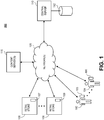
- FIG. 1 illustrates an overview of a system 100 of components configured to facilitate the systems and methods. It should be appreciated that the system 100 is merely an example and that alternative or additional components are envisioned.
- the system 100 may include a set of users 102, 104 or individuals having or interacting with a respective set of electronic devices 103, 105.
- Each of the users 102, 104 may be any individual or person who may be interested in purchasing products or services that may be offered for sale by a set of retail stores 106, 108.
- each of the set of retail stores 106, 108 may be associated with a retail location of an entity such as a corporation, company, partnership, or the like.
- the retail store 106 may be associated with example Convenience Store A and the retail store 108 may be associated with example Convenience Store B.
- Each of the electronic devices 103, 105 may be any type of electronic device such as a mobile device (e.g., a smartphone), notebook computer, tablet, phablet, GPS (Global Positioning System) or GPS-enabled device, smart watch, smart glasses, smart bracelet, wearable electronic, PDA (personal digital assistant), pager, computing device configured for wireless communication, and/or the like.
- the set of retail stores 106, 108 may include a respective set of computers 107, 109 or terminals associated therewith that may support a checkout procedure, a point of sale, and/or other functionalities.
- either or both users 102, 104 may purchase products or services from either of the retail stores 106, 108 through the use of the respective computers 107, 109.
- FIG. 1 Although two (2) retail stores 106, 108, two (2) sets of computers 107, 109, two (2) users 103, 105, and two (2) electronic devices 103, 105 are depicted in FIG. 1 , it should be appreciated that greater or fewer amounts are envisioned.
- the electronic devices 103, 105 and the computers 107, 109 may communicate with a central server 110 via one or more networks 120.
- the central server 110 may be associated with the entity that owns and/or manages a set of retail locations including the set of retail stores 106, 108.
- the network(s) 120 may support any type of data communication via any standard or technology (e.g., GSM, CDMA, TDMA, WCDMA, LTE, EDGE, OFDM, GPRS, EV-DO, UWB, Internet, IEEE 802 including Ethernet, WiMAX, Wi-Fi, Bluetooth, and others).
- the central server 110 may be configured to interface with or support a memory or storage 112 capable of storing various data, such as in one or more databases or other forms of storage.
- the storage 112 may store location-based data or information associated with the set of retail stores 106, 108.
- the data or information may be pertinent to the respective locations of the set of retail stores 106, 108, and may be indicative of an urban-rural classification of the respective locations, among other characteristics.
- the data or information may include addresses, population data, population density data, roadway information, business or retail density information, stoplight information, zoning information, demographic information, and/or other data or information. It should be appreciated that additional or alternative data pertinent to the respective locations of the set of retail stores 106, 108 is envisioned.
- the electronic devices 103, 105, the computers 107, 109, and/or the central server 110 may additionally communicate with a content server(s) 115 via the one or more networks 120.
- the content server(s) 115 may alternatively or additionally store the location-based data or information associated with the retail stores 106, 108, as described herein.
- at least the central server 110 may communicate with the content server(s) 115 to retrieve location-based information associated with a particular retail store(s).
- Each of the electronic devices 103, 105 may be configured with certain components to facilitate location-detection functionalities, such as a GPS chip and/or one or more transceivers (e.g., WWAN, WLAN, and/or WPAN transceivers), and/or the like.
- the respective components may receive, access, or generate data that may be indicative of a location of the respective electronic device 103, 105.
- the GPS chip may be configured to receive GPS coordinates from a GPS satellite(s)
- a WLAN transceiver may detect wireless access points, as well as the service set identifier (SSID) and media access control (MAC) information for each wireless access point, and cellular connection data from cellular towers.
- SSID service set identifier
- MAC media access control
- At least one of the electronic devices 103, 105 may transmit any combination of the location data to the central server 110 via the network(s) 120, where the combination of the location data may be indicative of an estimated location the of at least one of the electronic devices 103, 105.
- the central server 110 may determine, based on the estimated location(s) of the at least one of the electronic device 103, 105 and a location(s) of at least one of the retail stores 106, 108, whether the at least one of the electronic devices 103, 105 is proximate to (e.g., within a certain distance of) the at least one of the retail stores 106, 108.
- the central server 110 may calculate a geofencing boundary for at least one of the retail stores 106, 108, based on the location-based data or information associated with the retail store(s) 106, 108, and may determine whether the electronic device(s) 103, 105 is located within the geofencing boundary(ies). If the electronic device(s) 103, 105 is located within the geofencing boundary(ies), the central server 110 may facilitate certain location-based services, including initiating or activating certain geofencing functionalities supported by the electronic device(s) 103, 105.
- the central server 110 may cease or deactivate the certain functionalities supported by the electronic device(s) 103, 105 These functionalities are further discussed with respect to FIG. 2 .
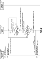
- FIG. 2 depicts a signal diagram 200 associated with managing location-based functionalities for implementation on an electronic device, in accordance with some embodiments.
- the signal diagram includes an electronic device 205 (such as either of the electronic devices 103, 105 as discussed with respect to FIG. 1 ) that may be operated by an individual, a central server 210 (such as the central server 110 as discussed with respect to FIG. 1 ), and a content server(s) 215 (such as the content server(s) 115 as discussed with respect to FIG. 1 ).
- the central server 210 and the content server(s) 215 may be, in combination, a set of back-end components that are remote from the electronic device 205, where the set of back-end components may be associated with a retail company having an associated set of retail stores or locations. It should be appreciated that additional or alternative components and devices are envisioned.
- the electronic device 205 may support and execute an application associated with the set of retail stores, where the application may be configured for different modes. For example, one of the modes may be "normal operation" (i.e., when the electronic device 205 is deemed to be not located within a retail store), and one of the modes may be "in-store mode” (i.e., when the electronic device 205 is deemed to be located in a retail store). Additionally, the electronic device 205 may support notifications, badges, banners, and/or the like that may be associated with the application.
- the signal diagram 200 may begin when the electronic device 205 collects (220) location data.
- the electronic device 205 may collect one or more different types of data that may be indicative of the location of the electronic device 205, or from which the location of the electronic device 205 may be estimated, calculated, or determined.
- the location data may consist of GPS coordinates that the electronic device 205 may receive from a GPS satellite(s).
- the location data may consist of cellular tower signal data that the electronic device 205 may receive from one or more proximate cellular towers, where the electronic device 205 may triangulate the cellular tower signal data to estimate its location.
- the location data may include wireless access point data (i.e., data indicative of detected nearby wireless access points), which may include service set identifier (SSID) data and/or media access control (MAC) address data of the respective access point.
- the wireless access point data may indicate an amount and density of detected nearby wireless access points.
- the wireless access point data may be reconciled with a database of known locations of the wireless access points. Accordingly, the wireless access point data may be used to determine or refine the location of the electronic device 205.
- the electronic device 205 may determine (222) its estimated location using one or more techniques and using any combination of the location data collected in (220) (i.e., GPS data, cellular tower signal data, and wireless access point data). For example, the electronic device 205 may derive its estimated location from GPS coordinates. For further example, the electronic device 205 may derive its estimated location from a combination of wireless access point data and a triangulation of cellular tower signal data.
- the electronic device 205 may transmit (224) the estimated location to the central server 210 via a network connection.
- the electronic device 205 may additionally or alternatively transmit at least a portion of the wireless access point data, where the portion of the wireless access point data may indicate an amount and/or density of access points detected by the electronic device 205.
- the central server 210 may access (226) location data associated with a set of retail stores.
- each retail store may have an associated location which may be represented by a set of latitude/longitude coordinates, which may represent an approximate center of the retail store.
- the location data may further include data indicative of the size or shape of the retail store, such as a footprint, perimeter, square footage, and/or other data. Additionally or alternatively, the location may include a default geofencing boundary for the retail store.
- the default geofencing boundary may be represented by different distances, shapes, and parameters.
- the default geofencing boundary for a given retail store may be a circle with a radius of fifty (50) meters, two hundred (200) meters, or other distances from the designated center of the given retail store.
- the central server 210 may determine (228) whether the electronic device 205 is in proximity to a retail store of the set of retail stores. In particular, the central server 210 may identify a retail store having a location that is closest to the estimated location of the electronic device 205, determine a distance between the estimated location of the electronic device 205 and the location of that retail store, and compare the determined distance to a threshold distance. If the determined distance exceeds (or at least meets) the threshold distance, then the central server 210 may deem that the electronic device 205 is not within proximity to a retail store ("NO"), and processing may repeat, end, or proceed to other functionality.
- NO retail store
- the central server 210 may deem that the electronic device 205 is within proximity to a retail store ("YES"), and processing may proceed to (230). It should be appreciated that the central server 210 may employ other techniques to determine whether the electronic device 205 is in proximity to a retail store of the set of retail stores.
- the central server 210 may optionally retrieve location information associated with the proximate retail store (and/or with the estimated location of the electronic device 205) from the content server(s) 215. It should be appreciated that the central server 210 may locally store or access location information associated with the set of retail stores, such as in a database, and/or that the central server 210 may previously interface with the content server(s) to retrieve and store the location information.
- the location information may include various data and information pertinent to the location of the proximate retail store, such as data indicative of an urban/rural classification for a specific area (e.g., a ZIP code) associated with a given retail store.
- the data and information may indicate addresses, population data, population density data, roadway information, business or retail density information, stoplight information, zoning information, demographic information, and/or other data or information.
- the central server 210 may calculate (232) a geofencing boundary for the retail store (i.e., the retail store that is closest to the estimated location of the electronic device 205). According to embodiments, the central server 210 may account for various variables, factors, or parameters, or combinations thereof, when calculating the geofencing boundary. Generally, the central server 210 may calculate the geofencing boundary based at least in part on the location information retrieved or accessed in (230). In an implementation, the central server 210 may calculate the geofencing boundary by modifying, based on the location information, the initial default geofencing boundary associated with the retail store.
- the calculated geofencing boundary may be represented by different distances, shapes, and parameters.
- the geofencing boundary for a given retail store may be a circle with a radius of fifty (50) meters, two hundred (200) meters, or other distances from the designated center of the given retail store.
- the geofencing boundary for a given retail store may encompass all publicly-accessible roadways and walkways within a radius of one hundred (100) meters of the designated center of the given retail store.
- Any population data included in the location data may reflect an urban/rural classification associated with the location or area of the retail store.
- the more rural the location/area the larger the geofencing boundary of the retail store may be to efficiently and effectively manage an in-store mode, so as to reduce false negative instances.
- the more urban the location/area the smaller the geofencing boundary of the retail store may be to efficiently and effectively manage an in-store mode, so as to reduce false positive instances.
- the central server 210 may determine, based at least in part on the respective population densities, that Retail Store A should have a geofencing boundary having a seventeen (17) meter radius and that Retail Store B should have a geofencing boundary having a two hundred ten (210) meter radius.
- the central server 210 may account for any or all of the location data accessed in (226) and/or any or all of the data or information transmitted from the electronic device 205 in (224). For example, assume that the electronic device 205 is located in Ames, Iowa, and sends wireless access point data to the central server 210 that indicates a larger amount of wireless networks available to the electronic device 205 (e.g., indicating that the electronic device 205 is located in a town center of Ames). Additionally, the size or footprint of Retail Store B may be larger than average. Accordingly, the central server 210 may account for the population density of Ames, the wireless access point data, and the larger footprint to determine that Retail Store B should have a geofencing boundary having a seventy five (75) meter radius.
- the central server 210 may utilize various formulas, models, calculations, algorithms, analyses, and relationships on various combinations of the available data or information. Additionally or alternatively, the central server 210 may weight certain parameters or factors different from other parameters or factors.
- the central server 210 may determine (234) whether the electronic device 205 is located within the geofencing boundary calculated in (232). For example, if the geofencing boundary is a circular area having a specified radius and a center being a designated location of the retail store, the central server 210 may determine whether the estimated location of the electronic device 205 is located in the circular area. If the estimated location of the electronic device 205 is not located within the geofencing boundary ("NO"), processing may repeat, end, or proceed to other functionality. If the estimated location of the electronic device 205 is located within the geofencing boundary ("YES"), processing may proceed to (236).
- the central server 210 may generate (236) a command or communication associated with or reflecting that the electronic device 205 is located within the geofencing boundary of the retail store.
- any command may be associated with an in-store mode (or similar mode) that may be triggered within an application that executes on the electronic device 205.
- any communication may be a notification or indication displayable by the electronic device 205 that may indicate that the electronic device 205 is deemed to be located in the retail store.
- the central server 210 may transmit (238) the command or communication to the electronic device 205 via a network connection. After receipt of the command or notification, the electronic device 205 may execute or display (240) the command or communication. In particular, if the central server 210 transmits a command to the electronic device 205, the electronic device 205 may execute the command to cause an application to perform a certain action. For example, if the application is associated with the retail store, the command may cause the application to enter an in-store mode that may enable a user of the electronic device 205 to review certain information or facilitate certain functionalities that are relevant or related to being within the retail store (e.g., viewing where items are located within the store, clipping coupons, facilitating with checkout, accessing account information, etc.).
- the electronic device 205 may display, via a user interface, the communication or a portion thereof.
- the communication may be a push notification that alerts the user of the electronic device 205 that the user is deemed to be within the retail store. It should be appreciated that additional various commands and communications are envisioned.
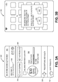
- FIGS. 3A and 3B illustrate example interfaces associated with the systems and methods.
- An electronic device e.g., a mobile device, such as a smartphone
- the electronic device may be configured to display the interfaces and/or receive selections and inputs via the interfaces, where the electronic device may be associated with a user who may be a customer or potential customer of a retail store.
- One or more dedicated applications that are configured to operate on the electronic device may display the interfaces. It should be appreciated that the interfaces are merely examples and that alternative or additional content is envisioned.
- FIG. 3A illustrates an interface 350 of an application associated with a retail store.
- the electronic device may receive a command from a central server to initiate an in-store mode of an application (such as if the central server detects that the electronic device is within a geofencing boundary for the retail store), and may accordingly display the interface 350 in response to receiving the command.
- the interface 350 includes an indication 351 that the in-store mode of the application has been activated, and an identification 352 of the retail store in which the electronic device is located.
- the interface 350 may further enable the user to make certain selections.
- the interface 350 includes a set of selections 354-357 for the following functionalities: clip coupons, find products, prescriptions & health, and shop products.
- the interface 350 includes an information section 353 that details certain information associated with a user account (as shown: available rewards, point balance, and points needed for next reward).
- FIG. 3B illustrates an interface 360 that may be displayed by the electronic device.
- the interface 360 may include a home screen of the electronic device with a notification 361 overlaid thereon.
- the electronic device may display the notification 361 in response to receiving a communication from a central server indicating that the electronic device is located at the retail store (such as if the central server detects that the electronic device is within a geofencing boundary for the retail store).
- the notification 361 may indicate that the electronic device was detected to have entered the store on 151 State Street. Further, the notification 361 enables the user to select whether to activate an in-store mode of an application (such as the in-store mode as illustrated in FIG. 3A ) via a "NO" selection 362 and a "YES” selection 363. According to embodiments, if the user selects the "NO” selection 362, the electronic device may dismiss the notification 361; and if the user selects the "YES” selection 363, the electronic device may activate the in-store mode.
- an in-store mode of an application such as the in-store mode as illustrated in FIG. 3A
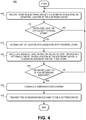
- FIG. 4 depicts is a block diagram of an example method 400 of processing geofencing features.
- the method 400 may be facilitated by a server (such as the central server 210 as discussed with respect to FIG. 2 ) that may be in communication with an electronic device of a user (such as the electronic device 205 as discussed with respect to FIG. 2 ).
- a server such as the central server 210 as discussed with respect to FIG. 2
- an electronic device of a user such as the electronic device 205 as discussed with respect to FIG. 2 .
- the method 400 may begin when the server receives (block 405), from the electronic device via a network connection, an estimated location of the electronic device.
- the estimated location may consist of at least one of: GPS coordinates of the electronic device, wireless access point data, and cellular triangulation data.
- the server may determine (block 410) whether the estimated location is in proximity to a retail store of a set of retail stores.
- the server may access a lookup table (or other data structure) that lists the set of retail stores having a respective set of locations, and may determine, from the data of the lookup table, that a distance between the estimated location of the electronic device and a location of the retail store does not exceed a threshold distance. If the server determines that the estimated location is not in proximity to the retail store ("NO"), processing may end, repeat, or proceed to other functionality. If the server determines that the estimated location is in proximity to the retail store (“YES”), processing may proceed to block 415.
- the server may access a set of location data associated with the retail store.
- the set of location data may include a combination of information associated with the location of the retail store, including addresses, population data, population density data, roadway information, business or retail density information, stoplight information, zoning information, demographic information, and/or other data or information.
- the set of location data may further indicate a size or geographic footprint of the retail store.
- the server may calculate (block 420), based at least in part on the set of location data and optionally the estimated location of the electronic device, a geofencing boundary for the retail store.
- the server may calculate the geofencing boundary based on any combination of the set of location data and/or the estimated location of the electronic device, including population data, wireless access point data, retail store size, and/or other data.
- the retail store may have a default geofencing boundary, and the server may modify (i.e., increase or decrease) the default geofencing boundary to calculate the geofencing boundary.
- the server may determine (block 425) whether the estimated location is within the geofencing boundary of the retail store. If the server determines that the estimated location is not within the geofencing boundary ("NO"), processing may end, repeat, or proceed to other functionality. If the server determines that the estimated location is within the geofencing boundary ("YES”), processing may proceed to block 430.
- the server may generate a communication or command.
- the communication or command may reflect that the electronic device is within the geofencing boundary (i.e., is deemed to be within the retail store).
- the server may transmit (block 435) the communication or command to the electronic device, which may display or activate the communication or command as appropriate.
- the electronic device may cause an application to activate an in-store mode associated with the retail store.
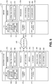
- FIG. 5 illustrates a hardware diagram of an example electronic device 505 (such as the electronic device 205 as discussed with respect to FIG. 2 ) and an example server 510 (such as the central server 210 as discussed with respect to FIG. 2 ), in which the functionalities as discussed herein may be implemented.
- an example electronic device 505 such as the electronic device 205 as discussed with respect to FIG. 2
- an example server 510 such as the central server 210 as discussed with respect to FIG. 2 , in which the functionalities as discussed herein may be implemented.
- the electronic device 505 may include a processor 572 as well as a memory 578.
- the memory 578 may store an operating system 579 capable of facilitating the functionalities as discussed herein as well as a set of applications 575 (i.e., machine readable instructions).
- one of the set of applications 575 may be a location analysis application 590 configured to facilitate various of the functionalities as discussed herein. It should be appreciated that one or more other applications 592 are envisioned.
- the processor 572 may interface with the memory 578 to execute the operating system 579 and the set of applications 575.
- the memory 578 may also store other data 580 that may include data accessed or collected by various sensors.
- the memory 578 may include one or more forms of volatile and/or non-volatile, fixed and/or removable memory, such as read-only memory (ROM), electronic programmable read-only memory (EPROM), random access memory (RAM), erasable electronic programmable read-only memory (EEPROM), and/or other hard drives, flash memory, MicroSD cards, and others.
- the electronic device 505 may further include a communication module 577 configured to communicate data via one or more networks 520.
- the communication module 577 may include one or more transceivers (e.g., WWAN, WLAN, and/or WPAN transceivers) functioning in accordance with IEEE standards, 3GPP standards, or other standards, and configured to receive and transmit data via one or more external ports 576.
- transceivers e.g., WWAN, WLAN, and/or WPAN transceivers
- the electronic device 505 may include a set of sensors 571 such as, for example, a location module (e.g., a GPS chip), an image sensor, an accelerometer, a clock, a gyroscope, a compass, a yaw rate sensor, a tilt sensor, telematics sensors, and/or other sensors.
- the electronic device 505 may further include a user interface 581 configured to present information to a user and/or receive inputs from the user. As shown in FIG. 5 , the user interface 581 may include a display screen 582 and I/O components 583 (e.g., ports, capacitive or resistive touch sensitive input panels, keys, buttons, lights, LEDs).
- the user may access the electronic device 505 via the user interface 581 to review information such as alerts or notifications, make selections, and/or perform other functions.
- the electronic device 505 may include a speaker 573 configured to output audio data and a microphone 574 configured to detect audio.
- the electronic device 505 may perform the functionalities as discussed herein as part of a "cloud" network or may otherwise communicate with other hardware or software components within the cloud to send, retrieve, or otherwise analyze data.
- the electronic device 505 may communicate and interface with the server 510 via the network(s) 520.
- the server 510 may include a processor 559 as well as a memory 556.
- the memory 556 may store an operating system 557 capable of facilitating the functionalities as discussed herein as well as a set of applications 551 (i.e., machine readable instructions).
- one of the set of applications 551 may be a location analysis application 552 configured to facilitate various of the functionalities discussed herein. It should be appreciated that one or more other applications 553 are envisioned.
- the processor 559 may interface with the memory 556 to execute the operating system 557 and the set of applications 551.
- the memory 556 may also store location data 558, such as location data associated with a set of retail stores.
- the memory 556 may include one or more forms of volatile and/or non-volatile, fixed and/or removable memory, such as read-only memory (ROM), electronic programmable read-only memory (EPROM), random access memory (RAM), erasable electronic programmable read-only memory (EEPROM), and/or other hard drives, flash memory, MicroSD cards, and others.
- the server 510 may further include a communication module 555 configured to communicate data via the one or more networks 520.
- the communication module 555 may include one or more transceivers (e.g., WWAN, WLAN, and/or WPAN transceivers) functioning in accordance with IEEE standards, 3GPP standards, or other standards, and configured to receive and transmit data via one or more external ports 554.
- the communication module 555 may receive, from the electronic device 505, location-based data.
- the server 510 may further include a user interface 562 configured to present information to a user and/or receive inputs from the user.
- the user interface 562 may include a display screen 563 and I/O components 564 (e.g., ports, capacitive or resistive touch sensitive input panels, keys, buttons, lights, LEDs).
- I/O components 564 e.g., ports, capacitive or resistive touch sensitive input panels, keys, buttons, lights, LEDs.
- the user may access the server 510 via the user interface 562 to review information, make changes, input training data, and/or perform other functions.
- the server 510 may perform the functionalities as discussed herein as part of a "cloud" network or may otherwise communicate with other hardware or software components within the cloud to send, retrieve, or otherwise analyze data.
- a computer program product in accordance with an embodiment may include a computer usable storage medium (e.g., standard random access memory (RAM), an optical disc, a universal serial bus (USB) drive, or the like) having computer-readable program code embodied therein, wherein the computer-readable program code may be adapted to be executed by the processors 572, 559 (e.g., working in connection with the respective operating systems 579, 557) to facilitate the functions as described herein.
- a computer usable storage medium e.g., standard random access memory (RAM), an optical disc, a universal serial bus (USB) drive, or the like
- the computer-readable program code may be adapted to be executed by the processors 572, 559 (e.g., working in connection with the respective operating systems 579, 557) to facilitate the functions as described herein.
- the program code may be implemented in any desired language, and may be implemented as machine code, assembly code, byte code, interpretable source code or the like (e.g., via Golang, Python, Scala, C, C++, Java, Actionscript, Objective-C, Javascript, CSS, XML).
- the computer program product may be part of a cloud network of resources.
- routines, subroutines, applications, or instructions may constitute either software (e.g., code embodied on a non-transitory, machine-readable medium) or hardware.
- routines, etc. are tangible units capable of performing certain operations and may be configured or arranged in a certain manner.
- one or more computer systems e.g., a standalone, client or server computer system
- one or more hardware modules of a computer system e.g., a processor or a group of processors
- software e.g., an application or application portion
- a hardware module may be implemented mechanically or electronically.
- a hardware module may comprise dedicated circuitry or logic that may be permanently configured (e.g., as a special-purpose processor, such as a field programmable gate array (FPGA) or an application-specific integrated circuit (ASIC)) to perform certain operations.
- a hardware module may also comprise programmable logic or circuitry (e.g., as encompassed within a general-purpose processor or other programmable processor) that may be temporarily configured by software to perform certain operations. It will be appreciated that the decision to implement a hardware module mechanically, in dedicated and permanently configured circuitry, or in temporarily configured circuitry (e.g., configured by software) may be driven by cost and time considerations.
- the term "hardware module” should be understood to encompass a tangible entity, be that an entity that is physically constructed, permanently configured (e.g., hardwired), or temporarily configured (e.g., programmed) to operate in a certain manner or to perform certain operations described herein.
- hardware modules are temporarily configured (e.g., programmed)
- each of the hardware modules need not be configured or instantiated at any one instance in time.
- the hardware modules comprise a general-purpose processor configured using software
- the general-purpose processor may be configured as respective different hardware modules at different times.
- Software may accordingly configure a processor, for example, to constitute a particular hardware module at one instance of time and to constitute a different hardware module at a different instance of time.
- Hardware modules may provide information to, and receive information from, other hardware modules. Accordingly, the described hardware modules may be regarded as being communicatively coupled. Where multiple of such hardware modules exist contemporaneously, communications may be achieved through signal transmission (e.g., over appropriate circuits and buses) that connect the hardware modules. In embodiments in which multiple hardware modules are configured or instantiated at different times, communications between such hardware modules may be achieved, for example, through the storage and retrieval of information in memory structures to which the multiple hardware modules have access. For example, one hardware module may perform an operation and store the output of that operation in a memory device to which it may be communicatively coupled. A further hardware module may then, at a later time, access the memory device to retrieve and process the stored output. Hardware modules may also initiate communications with input or output devices, and may operate on a resource (e.g., a collection of information).
- a resource e.g., a collection of information
- processors may be temporarily configured (e.g., by software) or permanently configured to perform the relevant operations. Whether temporarily or permanently configured, such processors may constitute processor-implemented modules that operate to perform one or more operations or functions.
- the modules referred to herein may, in some example embodiments, comprise processor-implemented modules.
- the methods or routines described herein may be at least partially processor-implemented. For example, at least some of the operations of a method may be performed by one or more processors or processor-implemented hardware modules. The performance of certain of the operations may be distributed among the one or more processors, not only residing within a single machine, but deployed across a number of machines. In some example embodiments, the processor or processors may be located in a single location (e.g., within a home environment, an office environment, or as a server farm), while in other embodiments the processors may be distributed across a number of locations.
- the performance of certain of the operations may be distributed among the one or more processors, not only residing within a single machine, but deployed across a number of machines.
- the one or more processors or processor-implemented modules may be located in a single geographic location (e.g., within a home environment, an office environment, or a server farm). In other example embodiments, the one or more processors or processor-implemented modules may be distributed across a number of geographic locations.
- any reference to "one embodiment” or “an embodiment” means that a particular element, feature, structure, or characteristic described in connection with the embodiment may be included in at least one embodiment.
- the appearances of the phrase “in one embodiment” in various places in the specification are not necessarily all referring to the same embodiment.
- the terms “comprises,” “comprising,” “may include,” “including,” “has,” “having” or any other variation thereof, are intended to cover a non-exclusive inclusion.
- a process, method, article, or apparatus that comprises a list of elements is not necessarily limited to only those elements but may include other elements not expressly listed or inherent to such process, method, article, or apparatus.
- “or” refers to an inclusive or and not to an exclusive or. For example, a condition A or B is satisfied by any one of the following: A is true (or present) and B is false (or not present), A is false (or not present) and B is true (or present), and both A and B are true (or present).
Landscapes
- Engineering & Computer Science (AREA)
- Business, Economics & Management (AREA)
- Signal Processing (AREA)
- Computer Networks & Wireless Communication (AREA)
- Accounting & Taxation (AREA)
- Finance (AREA)
- Marketing (AREA)
- Economics (AREA)
- General Business, Economics & Management (AREA)
- General Physics & Mathematics (AREA)
- Physics & Mathematics (AREA)
- Theoretical Computer Science (AREA)
- Strategic Management (AREA)
- Development Economics (AREA)
- Telephonic Communication Services (AREA)
- Telephone Function (AREA)
- Management, Administration, Business Operations System, And Electronic Commerce (AREA)
Claims (11)
- Computerimplementiertes Verfahren eines Verwaltens von Geofencing-Merkmalen in einem zentralen Server (210), das Folgendes umfasst:Empfangen (405), durch einen Transceiver des zentralen Servers von einer elektronischen Vorrichtung (205) über eine Netzwerkverbindung, i. eines geschätzten Standorts der elektronischen Vorrichtung und ii. von Daten von drahtlosen Zugangspunkten, die eine Menge und eine Dichte eines Satzes von drahtlosen Zugangspunkten angeben, die von der elektronischen Vorrichtung (205) erfasst werden;Bestimmen (410), durch einen Computerprozessor des zentralen Servers (210), dass der geschätzte Standort der elektronischen Vorrichtung in der Nähe eines Standorts eines Geschäfts ist;als Reaktion auf das Bestimmen, dass der geschätzte Standort der elektronischen Vorrichtung in der Nähe des Standorts des Geschäfts ist:Berechnen (420), durch den Computerprozessor, wenigstens teilweise basierend auf der Menge und der Dichte des Satzes von drahtlosen Zugangspunkten, die durch die elektronische Vorrichtung erfasst werden, einer Geofencing-Grenze für das Geschäft, undBestimmen (425), durch den Computerprozessor, dass der geschätzte Standort der elektronischen Vorrichtung innerhalb der Geofencing-Grenze für das Geschäft liegt; und Übertragen (435), durch den Transceiver an die elektronische Vorrichtung über die Netzwerkverbindung, einer Kommunikation, die widerspiegelt, dass der geschätzte Standort der elektronischen Vorrichtung innerhalb der Geofencing-Grenze für das Geschäft liegt.
- Computerimplementiertes Verfahren nach Anspruch 1, wobei das Empfangen des geschätzten Standorts der elektronischen Vorrichtung Folgendes umfasst:
Empfangen von: GPS-Koordinaten der elektronischen Vorrichtung und/oder zellularen Triangulationsdaten. - Computerimplementiertes Verfahren nach einem der vorhergehenden Ansprüche, wobei das Bestimmen, dass der geschätzte Standort der elektronischen Vorrichtung in der Nähe des Standorts des Geschäfts ist, Folgendes umfasst:Zugreifen auf eine Nachschlagetabelle, die mehrere Geschäfte auflistet, die jeweils mehrere Standorte aufweisen; undBestimmen, aus der Nachschlagetabelle, dass ein Abstand zwischen dem geschätzten Standort der elektronischen Vorrichtung und dem Standort des Geschäfts einen Schwellenabstand nicht überschreitet.
- Computerimplementiertes Verfahren nach einem der vorhergehenden Ansprüche, wobei das Berechnen der Geofencing-Grenze für das Geschäft ferner auf einer Größe des Geschäfts basiert.
- Computerimplementiertes Verfahren nach einem der vorhergehenden Ansprüche, wobei das Übertragen, an die elektronische Vorrichtung über die Netzwerkverbindung, der Kommunikation, die widerspiegelt, dass der geschätzte Standort der elektronischen Vorrichtung innerhalb der Geofencing-Grenze für das Geschäft liegt, Folgendes umfasst:
Übertragen der Kommunikation an die elektronische Vorrichtung über die Netzwerkverbindung, wobei die Kommunikation veranlasst, dass eine Anwendung, die auf der elektronischen Vorrichtung ausgeführt wird, einen mit dem Geschäft verknüpften Im-Geschäft-Modus aktiviert. - System für einen zentralen Server (210) zum Verwalten von Standortmerkmalen, wobei das System Folgendes umfasst:einen Transceiver zum Kommunizieren mit einer elektronischen Vorrichtung (205) über eine Netzwerkverbindung;einen Speicher, der Folgendes speichert:i. Standortdaten, die mit einem Satz von Geschäften verknüpft sind, undii. nichtflüchtige computerausführbare Anweisungen; undeinen Prozessor, der mit dem Transceiver und dem Speicher verbunden ist, wobei der Prozessor konfiguriert ist, um die nicht-flüchtigen computerausführbaren Befehle auszuführen, um den Prozessor zu Folgendem zu veranlassen:Empfangen, von der elektronischen Vorrichtung über den Transceiver, i. eines geschätzten Standorts der elektronischen Vorrichtung und ii. von Daten der drahtlosen Zugangspunkte, die eine Menge und eine Dichte eines Satzes von drahtlosen Zugangspunkten angeben, die durch die elektronische Vorrichtung erfasst werden,Identifizieren, aus den in dem Speicher gespeicherten Standortsdaten, eines Geschäfts des Satzes von Geschäften, das einen Standort aufweist, der in der Nähe des geschätzten Standorts der elektronischen Vorrichtung ist,Berechnen, wenigstens teilweise basierend auf der Menge und der Dichte des Satzes von drahtlosen Zugangspunkten, die durch die elektronische Vorrichtung erfasst werden, einer Geofencing-Grenze für das Geschäft,Bestimmen, dass der geschätzte Standort der elektronischen Vorrichtung innerhalb der Geofencing-Grenze für das Geschäft liegt,Erzeugen eines Befehls, der damit verknüpft ist, dass der geschätzte Standort der elektronischen Vorrichtung innerhalb der Geofencing-Grenze für das Geschäft liegt, undÜbertragen des Befehls an die elektronische Vorrichtung über den Transceiver, wobei der Befehl einer Ausführung durch die elektronische Vorrichtung dient.
- System nach Anspruch 6, wobei der geschätzte Standort Folgendes umfasst: GPS-Koordinaten der elektronischen Vorrichtung und/oder zellulare Triangulationsdaten.
- System nach Anspruch 6 oder 7, wobei der Prozessor, um das Geschäft des Satzes von Geschäften zu identifizieren, das einen Standort aufweist, der in der Nähe des geschätzten Standorts der elektronischen Vorrichtung ist, für Folgendes konfiguriert ist:
Bestimmen, dass ein Abstand zwischen dem geschätzten Standort der elektronischen Vorrichtung und dem Standort des Geschäfts einen Schwellenabstand nicht überschreitet. - System nach den Ansprüchen 6 bis 8, wobei der Befehl, wenn er durch die elektronische Vorrichtung ausgeführt wird, veranlasst, dass eine Anwendung der elektronischen Vorrichtung einen Im-Geschäft-Modus einleitet.
- System nach den Ansprüchen 6 bis 9, wobei der Befehl, wenn er durch die elektronische Vorrichtung ausgeführt wird, veranlasst, dass die elektronische Vorrichtung eine Benachrichtigung anzeigt, die angibt, dass sich die elektronische Vorrichtung innerhalb des Geschäfts befindet.
- Computerprogramm, das, wenn es auf einem Prozessor einer Rechenvorrichtung ausgeführt wird, die in einem System nach Anspruch 6 enthalten ist, konfiguriert ist, um das Verfahren nach einem der Ansprüche 1 bis 5 vorzunehmen.
Priority Applications (1)
| Application Number | Priority Date | Filing Date | Title |
|---|---|---|---|
| EP21202252.9A EP3962123A1 (de) | 2018-04-16 | 2019-04-03 | Technologie zur verwaltung von standortbasierten funktionalitäten für elektronische vorrichtungen |
Applications Claiming Priority (1)
| Application Number | Priority Date | Filing Date | Title |
|---|---|---|---|
| US15/954,264 US10440509B1 (en) | 2018-04-16 | 2018-04-16 | Technology for managing location-based functionalities for electronic devices |
Related Child Applications (2)
| Application Number | Title | Priority Date | Filing Date |
|---|---|---|---|
| EP21202252.9A Division-Into EP3962123A1 (de) | 2018-04-16 | 2019-04-03 | Technologie zur verwaltung von standortbasierten funktionalitäten für elektronische vorrichtungen |
| EP21202252.9A Division EP3962123A1 (de) | 2018-04-16 | 2019-04-03 | Technologie zur verwaltung von standortbasierten funktionalitäten für elektronische vorrichtungen |
Publications (2)
| Publication Number | Publication Date |
|---|---|
| EP3557515A1 EP3557515A1 (de) | 2019-10-23 |
| EP3557515B1 true EP3557515B1 (de) | 2021-11-17 |
Family
ID=66323650
Family Applications (2)
| Application Number | Title | Priority Date | Filing Date |
|---|---|---|---|
| EP19167175.9A Active EP3557515B1 (de) | 2018-04-16 | 2019-04-03 | Technologie zur steuerung von ortsbasierten funktionalitäten eines elektronischen gerätes |
| EP21202252.9A Withdrawn EP3962123A1 (de) | 2018-04-16 | 2019-04-03 | Technologie zur verwaltung von standortbasierten funktionalitäten für elektronische vorrichtungen |
Family Applications After (1)
| Application Number | Title | Priority Date | Filing Date |
|---|---|---|---|
| EP21202252.9A Withdrawn EP3962123A1 (de) | 2018-04-16 | 2019-04-03 | Technologie zur verwaltung von standortbasierten funktionalitäten für elektronische vorrichtungen |
Country Status (2)
| Country | Link |
|---|---|
| US (5) | US10440509B1 (de) |
| EP (2) | EP3557515B1 (de) |
Families Citing this family (5)
| Publication number | Priority date | Publication date | Assignee | Title |
|---|---|---|---|---|
| CN111275597B (zh) * | 2020-01-16 | 2023-02-14 | 华南理工大学 | 社区生活圈空间识别方法、系统、计算机设备及存储介质 |
| CA3115476A1 (en) * | 2020-04-17 | 2021-10-17 | Oshkosh Corporation | Active truck tracking and alerts for residential refuse can collection |
| CN111966768B (zh) * | 2020-06-29 | 2023-11-17 | 北京百度网讯科技有限公司 | 地址描述方法、装置、电子设备和存储介质 |
| US12265997B2 (en) * | 2021-04-26 | 2025-04-01 | Walmart Apollo, Llc | Systems and methods for user engagement with a retailer |
| US12120577B2 (en) * | 2022-04-28 | 2024-10-15 | At&T Intellectual Property I, L.P. | Location-based communication using wireless device |
Family Cites Families (39)
| Publication number | Priority date | Publication date | Assignee | Title |
|---|---|---|---|---|
| AU2006220547B2 (en) | 2005-03-07 | 2010-12-02 | Telecommunication Systems, Inc. | Method and system for identifying and defining geofences |
| US9070305B1 (en) * | 2010-01-22 | 2015-06-30 | Google Inc. | Traffic light detecting system and method |
| US8682300B2 (en) * | 2011-05-30 | 2014-03-25 | Microsoft Corporation | Adaptation of notification perimeter based on relevance to a user |
| US8471701B2 (en) * | 2011-05-30 | 2013-06-25 | Microsoft Corporation | Asymmetric dynamic geo-fencing |
| WO2013044070A2 (en) * | 2011-09-21 | 2013-03-28 | Jeff Thramann | Systems and methods for tracking mobile devices |
| US9002380B2 (en) * | 2012-06-08 | 2015-04-07 | Apple Inc. | Proximity-based notifications in a mobile device |
| US9432806B2 (en) * | 2012-12-04 | 2016-08-30 | Ebay Inc. | Dynamic geofence based on members within |
| US10380636B2 (en) * | 2012-12-06 | 2019-08-13 | Ebay Inc. | Systems and methods for statistical dynamic geofencing |
| EP2744234B1 (de) | 2012-12-11 | 2018-10-10 | BlackBerry Limited | Geofencing-system und verfahren |
| CN104919395B (zh) * | 2013-02-22 | 2019-07-02 | 英特尔公司 | 触摸使能设备上的地理围栏创建 |
| US10219304B2 (en) * | 2013-05-16 | 2019-02-26 | Sony Corporation | Operating a terminal device in a wireless communication system |
| US9013333B2 (en) * | 2013-06-24 | 2015-04-21 | Gordon*Howard Associates, Inc. | Methods and systems related to time triggered geofencing |
| US9179257B2 (en) * | 2013-08-21 | 2015-11-03 | Pitney Bowes Inc. | Method and system for determining high precision geo-fencing using business property boundaries |
| US9187099B2 (en) * | 2013-10-17 | 2015-11-17 | Richard M. Powers | Systems and methods for predicting weather performance for a vehicle |
| US10445777B2 (en) | 2013-10-29 | 2019-10-15 | Verizon Patent And Licensing Inc. | Methods and systems for delivering electronic content to users in population based geographic zones |
| US9936346B2 (en) * | 2013-11-28 | 2018-04-03 | Microsoft Technology Licensing, Llc | Geofences from context and crowd-sourcing |
| US9307359B2 (en) * | 2013-12-05 | 2016-04-05 | Ebay Inc. | Methods, systems, and apparatus for a geo-fence system |
| CN106031129A (zh) * | 2013-12-11 | 2016-10-12 | 霍尼韦尔国际公司 | 建筑物自动化控制系统 |
| US8892310B1 (en) * | 2014-02-21 | 2014-11-18 | Smartdrive Systems, Inc. | System and method to detect execution of driving maneuvers |
| US9749781B2 (en) * | 2014-03-19 | 2017-08-29 | Oath Inc. | Systems and methods for optimizing message notification based on geographic location and time |
| US20150294362A1 (en) * | 2014-04-15 | 2015-10-15 | First Data Corporation | Systems and Methods for Managing Account Information |
| US9990659B2 (en) * | 2014-05-28 | 2018-06-05 | Cellco Partnership | In-store self-serve and zoning using geo-fencing |
| US9593954B2 (en) * | 2014-08-28 | 2017-03-14 | Telenav, Inc. | Navigation system with content delivery mechanism and method of operation thereof |
| US10091646B2 (en) * | 2014-08-29 | 2018-10-02 | Apple Inc. | Reduced resolution location determination for improved anonymity of user location |
| CN105528384B (zh) * | 2014-10-27 | 2019-03-15 | 阿里巴巴集团控股有限公司 | 信息的推送方法和装置 |
| US10282753B2 (en) * | 2014-12-10 | 2019-05-07 | Ebay Inc. | Geo-fenced marketplace |
| KR102272799B1 (ko) * | 2015-01-05 | 2021-07-05 | 에스케이플래닛 주식회사 | 지오펜스를 위한 무선통신 기능의 자동 활성화 장치 및 방법, 그리고 이를 포함하는 시스템 및 컴퓨터 프로그램이 기록된 기록매체 |
| US10825041B1 (en) * | 2015-05-01 | 2020-11-03 | UberMedia, Inc. | Real-time optimization of bid selection |
| US9866552B2 (en) * | 2015-05-08 | 2018-01-09 | International Business Machines Corporation | Network authentication of a geo-fenced volume |
| US9609973B1 (en) * | 2015-05-24 | 2017-04-04 | Anthem Andrew Pleasant | Automated postal delivery notification based on geolocation |
| RU2609082C2 (ru) * | 2015-06-30 | 2017-01-30 | Общество С Ограниченной Ответственностью "Яндекс" | Способ и система определения адреса, соответствующего наиболее вероятному физическому положению электронного устройства, связанного с пользователем |
| US9571968B1 (en) * | 2015-07-21 | 2017-02-14 | International Business Machines Corporation | Geo-fence management using a cluster analysis technique |
| US9709660B1 (en) * | 2016-01-11 | 2017-07-18 | Qualcomm Incorporated | Crowdsourced user density applications |
| US10733631B2 (en) * | 2016-05-05 | 2020-08-04 | State Farm Mutual Automobile Insurance Company | Using cognitive computing to provide targeted offers for preferred products to a user via a mobile device |
| RU2730782C1 (ru) * | 2016-10-04 | 2020-08-26 | Ниссан Мотор Ко., Лтд. | Способ управления парковкой и оборудование управления парковкой |
| EP3551966B1 (de) * | 2016-12-06 | 2021-03-03 | Nissan North America, Inc. | Lösungspfadüberlagerungsschnittstellen für autonome fahrzeuge |
| US10085117B2 (en) * | 2016-12-15 | 2018-09-25 | DISH Technologies L.L.C. | Methods and apparatus for altitude-based geofencing |
| US11049142B2 (en) * | 2017-02-16 | 2021-06-29 | Adobe Inc. | Smart geo-fencing using location sensitive product affinity |
| US10631262B2 (en) * | 2017-10-25 | 2020-04-21 | T-Mobile Usa, Inc. | Determining device location |
-
2018
- 2018-04-16 US US15/954,264 patent/US10440509B1/en active Active
-
2019
- 2019-04-03 EP EP19167175.9A patent/EP3557515B1/de active Active
- 2019-04-03 EP EP21202252.9A patent/EP3962123A1/de not_active Withdrawn
- 2019-08-20 US US16/544,974 patent/US10715954B1/en active Active
-
2020
- 2020-05-29 US US16/888,333 patent/US11405747B1/en active Active
-
2022
- 2022-06-30 US US17/855,381 patent/US11843989B1/en active Active
-
2023
- 2023-09-18 US US18/369,670 patent/US12363503B1/en active Active
Also Published As
| Publication number | Publication date |
|---|---|
| US10440509B1 (en) | 2019-10-08 |
| US10715954B1 (en) | 2020-07-14 |
| US20190320287A1 (en) | 2019-10-17 |
| US11405747B1 (en) | 2022-08-02 |
| US12363503B1 (en) | 2025-07-15 |
| US11843989B1 (en) | 2023-12-12 |
| EP3557515A1 (de) | 2019-10-23 |
| EP3962123A1 (de) | 2022-03-02 |
Similar Documents
| Publication | Publication Date | Title |
|---|---|---|
| US12363503B1 (en) | Technology for managing location-based functionalities for electronic devices | |
| US11153712B2 (en) | Configuring mobile device applications based on location | |
| CN106165463B (zh) | 选择与地理围栏相关的用户 | |
| CN109040972B (zh) | 基于动态地理围栏内的成员的动态地理围栏 | |
| US10127595B1 (en) | Categorization of items based on attributes | |
| EP2640098B1 (de) | System zur Bereitstellung erweiterbarer standortbasierter Dienste | |
| JP2018528505A (ja) | モバイルデバイスのロケーション履歴記録を提供、編成、および管理すること | |
| WO2013049922A1 (en) | Mobile user profile and preferences from movement patterns | |
| US20200013041A1 (en) | Crowd-location based transactions |
Legal Events
| Date | Code | Title | Description |
|---|---|---|---|
| PUAI | Public reference made under article 153(3) epc to a published international application that has entered the european phase |
Free format text: ORIGINAL CODE: 0009012 |
|
| STAA | Information on the status of an ep patent application or granted ep patent |
Free format text: STATUS: THE APPLICATION HAS BEEN PUBLISHED |
|
| AK | Designated contracting states |
Kind code of ref document: A1 Designated state(s): AL AT BE BG CH CY CZ DE DK EE ES FI FR GB GR HR HU IE IS IT LI LT LU LV MC MK MT NL NO PL PT RO RS SE SI SK SM TR |
|
| AX | Request for extension of the european patent |
Extension state: BA ME |
|
| STAA | Information on the status of an ep patent application or granted ep patent |
Free format text: STATUS: REQUEST FOR EXAMINATION WAS MADE |
|
| 17P | Request for examination filed |
Effective date: 20200423 |
|
| RBV | Designated contracting states (corrected) |
Designated state(s): AL AT BE BG CH CY CZ DE DK EE ES FI FR GB GR HR HU IE IS IT LI LT LU LV MC MK MT NL NO PL PT RO RS SE SI SK SM TR |
|
| REG | Reference to a national code |
Ref country code: DE Ref legal event code: R079 Ref document number: 602019009269 Country of ref document: DE Free format text: PREVIOUS MAIN CLASS: G06Q0030020000 Ipc: H04W0004021000 |
|
| RIC1 | Information provided on ipc code assigned before grant |
Ipc: H04W 4/021 20180101AFI20210421BHEP Ipc: G06Q 30/06 20120101ALN20210421BHEP |
|
| GRAP | Despatch of communication of intention to grant a patent |
Free format text: ORIGINAL CODE: EPIDOSNIGR1 |
|
| STAA | Information on the status of an ep patent application or granted ep patent |
Free format text: STATUS: GRANT OF PATENT IS INTENDED |
|
| RIC1 | Information provided on ipc code assigned before grant |
Ipc: H04W 4/021 20180101AFI20210526BHEP Ipc: G06Q 30/06 20120101ALN20210526BHEP |
|
| INTG | Intention to grant announced |
Effective date: 20210611 |
|
| GRAS | Grant fee paid |
Free format text: ORIGINAL CODE: EPIDOSNIGR3 |
|
| GRAA | (expected) grant |
Free format text: ORIGINAL CODE: 0009210 |
|
| STAA | Information on the status of an ep patent application or granted ep patent |
Free format text: STATUS: THE PATENT HAS BEEN GRANTED |
|
| AK | Designated contracting states |
Kind code of ref document: B1 Designated state(s): AL AT BE BG CH CY CZ DE DK EE ES FI FR GB GR HR HU IE IS IT LI LT LU LV MC MK MT NL NO PL PT RO RS SE SI SK SM TR |
|
| REG | Reference to a national code |
Ref country code: GB Ref legal event code: FG4D |
|
| REG | Reference to a national code |
Ref country code: DE Ref legal event code: R096 Ref document number: 602019009269 Country of ref document: DE |
|
| REG | Reference to a national code |
Ref country code: IE Ref legal event code: FG4D |
|
| REG | Reference to a national code |
Ref country code: AT Ref legal event code: REF Ref document number: 1449032 Country of ref document: AT Kind code of ref document: T Effective date: 20211215 |
|
| REG | Reference to a national code |
Ref country code: LT Ref legal event code: MG9D |
|
| REG | Reference to a national code |
Ref country code: NL Ref legal event code: MP Effective date: 20211117 |
|
| REG | Reference to a national code |
Ref country code: AT Ref legal event code: MK05 Ref document number: 1449032 Country of ref document: AT Kind code of ref document: T Effective date: 20211117 |
|
| PG25 | Lapsed in a contracting state [announced via postgrant information from national office to epo] |
Ref country code: RS Free format text: LAPSE BECAUSE OF FAILURE TO SUBMIT A TRANSLATION OF THE DESCRIPTION OR TO PAY THE FEE WITHIN THE PRESCRIBED TIME-LIMIT Effective date: 20211117 Ref country code: LT Free format text: LAPSE BECAUSE OF FAILURE TO SUBMIT A TRANSLATION OF THE DESCRIPTION OR TO PAY THE FEE WITHIN THE PRESCRIBED TIME-LIMIT Effective date: 20211117 Ref country code: FI Free format text: LAPSE BECAUSE OF FAILURE TO SUBMIT A TRANSLATION OF THE DESCRIPTION OR TO PAY THE FEE WITHIN THE PRESCRIBED TIME-LIMIT Effective date: 20211117 Ref country code: BG Free format text: LAPSE BECAUSE OF FAILURE TO SUBMIT A TRANSLATION OF THE DESCRIPTION OR TO PAY THE FEE WITHIN THE PRESCRIBED TIME-LIMIT Effective date: 20220217 Ref country code: AT Free format text: LAPSE BECAUSE OF FAILURE TO SUBMIT A TRANSLATION OF THE DESCRIPTION OR TO PAY THE FEE WITHIN THE PRESCRIBED TIME-LIMIT Effective date: 20211117 |
|
| PG25 | Lapsed in a contracting state [announced via postgrant information from national office to epo] |
Ref country code: IS Free format text: LAPSE BECAUSE OF FAILURE TO SUBMIT A TRANSLATION OF THE DESCRIPTION OR TO PAY THE FEE WITHIN THE PRESCRIBED TIME-LIMIT Effective date: 20220317 Ref country code: SE Free format text: LAPSE BECAUSE OF FAILURE TO SUBMIT A TRANSLATION OF THE DESCRIPTION OR TO PAY THE FEE WITHIN THE PRESCRIBED TIME-LIMIT Effective date: 20211117 Ref country code: PT Free format text: LAPSE BECAUSE OF FAILURE TO SUBMIT A TRANSLATION OF THE DESCRIPTION OR TO PAY THE FEE WITHIN THE PRESCRIBED TIME-LIMIT Effective date: 20220317 Ref country code: PL Free format text: LAPSE BECAUSE OF FAILURE TO SUBMIT A TRANSLATION OF THE DESCRIPTION OR TO PAY THE FEE WITHIN THE PRESCRIBED TIME-LIMIT Effective date: 20211117 Ref country code: NO Free format text: LAPSE BECAUSE OF FAILURE TO SUBMIT A TRANSLATION OF THE DESCRIPTION OR TO PAY THE FEE WITHIN THE PRESCRIBED TIME-LIMIT Effective date: 20220217 Ref country code: NL Free format text: LAPSE BECAUSE OF FAILURE TO SUBMIT A TRANSLATION OF THE DESCRIPTION OR TO PAY THE FEE WITHIN THE PRESCRIBED TIME-LIMIT Effective date: 20211117 Ref country code: LV Free format text: LAPSE BECAUSE OF FAILURE TO SUBMIT A TRANSLATION OF THE DESCRIPTION OR TO PAY THE FEE WITHIN THE PRESCRIBED TIME-LIMIT Effective date: 20211117 Ref country code: HR Free format text: LAPSE BECAUSE OF FAILURE TO SUBMIT A TRANSLATION OF THE DESCRIPTION OR TO PAY THE FEE WITHIN THE PRESCRIBED TIME-LIMIT Effective date: 20211117 Ref country code: GR Free format text: LAPSE BECAUSE OF FAILURE TO SUBMIT A TRANSLATION OF THE DESCRIPTION OR TO PAY THE FEE WITHIN THE PRESCRIBED TIME-LIMIT Effective date: 20220218 Ref country code: ES Free format text: LAPSE BECAUSE OF FAILURE TO SUBMIT A TRANSLATION OF THE DESCRIPTION OR TO PAY THE FEE WITHIN THE PRESCRIBED TIME-LIMIT Effective date: 20211117 |
|
| PG25 | Lapsed in a contracting state [announced via postgrant information from national office to epo] |
Ref country code: SM Free format text: LAPSE BECAUSE OF FAILURE TO SUBMIT A TRANSLATION OF THE DESCRIPTION OR TO PAY THE FEE WITHIN THE PRESCRIBED TIME-LIMIT Effective date: 20211117 Ref country code: SK Free format text: LAPSE BECAUSE OF FAILURE TO SUBMIT A TRANSLATION OF THE DESCRIPTION OR TO PAY THE FEE WITHIN THE PRESCRIBED TIME-LIMIT Effective date: 20211117 Ref country code: RO Free format text: LAPSE BECAUSE OF FAILURE TO SUBMIT A TRANSLATION OF THE DESCRIPTION OR TO PAY THE FEE WITHIN THE PRESCRIBED TIME-LIMIT Effective date: 20211117 Ref country code: EE Free format text: LAPSE BECAUSE OF FAILURE TO SUBMIT A TRANSLATION OF THE DESCRIPTION OR TO PAY THE FEE WITHIN THE PRESCRIBED TIME-LIMIT Effective date: 20211117 Ref country code: DK Free format text: LAPSE BECAUSE OF FAILURE TO SUBMIT A TRANSLATION OF THE DESCRIPTION OR TO PAY THE FEE WITHIN THE PRESCRIBED TIME-LIMIT Effective date: 20211117 Ref country code: CZ Free format text: LAPSE BECAUSE OF FAILURE TO SUBMIT A TRANSLATION OF THE DESCRIPTION OR TO PAY THE FEE WITHIN THE PRESCRIBED TIME-LIMIT Effective date: 20211117 |
|
| REG | Reference to a national code |
Ref country code: DE Ref legal event code: R097 Ref document number: 602019009269 Country of ref document: DE |
|
| PLBE | No opposition filed within time limit |
Free format text: ORIGINAL CODE: 0009261 |
|
| STAA | Information on the status of an ep patent application or granted ep patent |
Free format text: STATUS: NO OPPOSITION FILED WITHIN TIME LIMIT |
|
| 26N | No opposition filed |
Effective date: 20220818 |
|
| PG25 | Lapsed in a contracting state [announced via postgrant information from national office to epo] |
Ref country code: AL Free format text: LAPSE BECAUSE OF FAILURE TO SUBMIT A TRANSLATION OF THE DESCRIPTION OR TO PAY THE FEE WITHIN THE PRESCRIBED TIME-LIMIT Effective date: 20211117 |
|
| REG | Reference to a national code |
Ref country code: DE Ref legal event code: R119 Ref document number: 602019009269 Country of ref document: DE |
|
| PG25 | Lapsed in a contracting state [announced via postgrant information from national office to epo] |
Ref country code: SI Free format text: LAPSE BECAUSE OF FAILURE TO SUBMIT A TRANSLATION OF THE DESCRIPTION OR TO PAY THE FEE WITHIN THE PRESCRIBED TIME-LIMIT Effective date: 20211117 |
|
| REG | Reference to a national code |
Ref country code: CH Ref legal event code: PL |
|
| REG | Reference to a national code |
Ref country code: BE Ref legal event code: MM Effective date: 20220430 |
|
| PG25 | Lapsed in a contracting state [announced via postgrant information from national office to epo] |
Ref country code: MC Free format text: LAPSE BECAUSE OF FAILURE TO SUBMIT A TRANSLATION OF THE DESCRIPTION OR TO PAY THE FEE WITHIN THE PRESCRIBED TIME-LIMIT Effective date: 20211117 Ref country code: LU Free format text: LAPSE BECAUSE OF NON-PAYMENT OF DUE FEES Effective date: 20220403 Ref country code: LI Free format text: LAPSE BECAUSE OF NON-PAYMENT OF DUE FEES Effective date: 20220430 Ref country code: FR Free format text: LAPSE BECAUSE OF NON-PAYMENT OF DUE FEES Effective date: 20220430 Ref country code: DE Free format text: LAPSE BECAUSE OF NON-PAYMENT OF DUE FEES Effective date: 20221103 Ref country code: CH Free format text: LAPSE BECAUSE OF NON-PAYMENT OF DUE FEES Effective date: 20220430 |
|
| PG25 | Lapsed in a contracting state [announced via postgrant information from national office to epo] |
Ref country code: BE Free format text: LAPSE BECAUSE OF NON-PAYMENT OF DUE FEES Effective date: 20220430 |
|
| PG25 | Lapsed in a contracting state [announced via postgrant information from national office to epo] |
Ref country code: IT Free format text: LAPSE BECAUSE OF FAILURE TO SUBMIT A TRANSLATION OF THE DESCRIPTION OR TO PAY THE FEE WITHIN THE PRESCRIBED TIME-LIMIT Effective date: 20211117 |
|
| PG25 | Lapsed in a contracting state [announced via postgrant information from national office to epo] |
Ref country code: HU Free format text: LAPSE BECAUSE OF FAILURE TO SUBMIT A TRANSLATION OF THE DESCRIPTION OR TO PAY THE FEE WITHIN THE PRESCRIBED TIME-LIMIT; INVALID AB INITIO Effective date: 20190403 |
|
| PGFP | Annual fee paid to national office [announced via postgrant information from national office to epo] |
Ref country code: IE Payment date: 20240223 Year of fee payment: 6 |
|
| PG25 | Lapsed in a contracting state [announced via postgrant information from national office to epo] |
Ref country code: MK Free format text: LAPSE BECAUSE OF FAILURE TO SUBMIT A TRANSLATION OF THE DESCRIPTION OR TO PAY THE FEE WITHIN THE PRESCRIBED TIME-LIMIT Effective date: 20211117 Ref country code: CY Free format text: LAPSE BECAUSE OF FAILURE TO SUBMIT A TRANSLATION OF THE DESCRIPTION OR TO PAY THE FEE WITHIN THE PRESCRIBED TIME-LIMIT Effective date: 20211117 |
|
| PGFP | Annual fee paid to national office [announced via postgrant information from national office to epo] |
Ref country code: GB Payment date: 20240222 Year of fee payment: 6 |
|
| PG25 | Lapsed in a contracting state [announced via postgrant information from national office to epo] |
Ref country code: MT Free format text: LAPSE BECAUSE OF FAILURE TO SUBMIT A TRANSLATION OF THE DESCRIPTION OR TO PAY THE FEE WITHIN THE PRESCRIBED TIME-LIMIT Effective date: 20211117 |
|
| PG25 | Lapsed in a contracting state [announced via postgrant information from national office to epo] |
Ref country code: TR Free format text: LAPSE BECAUSE OF FAILURE TO SUBMIT A TRANSLATION OF THE DESCRIPTION OR TO PAY THE FEE WITHIN THE PRESCRIBED TIME-LIMIT Effective date: 20211117 |
|
| GBPC | Gb: european patent ceased through non-payment of renewal fee |
Effective date: 20250403 |
|
| PG25 | Lapsed in a contracting state [announced via postgrant information from national office to epo] |
Ref country code: GB Free format text: LAPSE BECAUSE OF NON-PAYMENT OF DUE FEES Effective date: 20250403 |