EP3548924B1 - Sar-basierte überwachung von unsichtbaren oder nicht immer sichtbaren oder teilweise sichtbaren zielen sowie zugehörige systeme und verfahren zur überwachung, erkennung von kritischen situationen und frühwarnung - Google Patents
Sar-basierte überwachung von unsichtbaren oder nicht immer sichtbaren oder teilweise sichtbaren zielen sowie zugehörige systeme und verfahren zur überwachung, erkennung von kritischen situationen und frühwarnung Download PDFInfo
- Publication number
- EP3548924B1 EP3548924B1 EP17832332.5A EP17832332A EP3548924B1 EP 3548924 B1 EP3548924 B1 EP 3548924B1 EP 17832332 A EP17832332 A EP 17832332A EP 3548924 B1 EP3548924 B1 EP 3548924B1
- Authority
- EP
- European Patent Office
- Prior art keywords
- electromagnetic
- sar
- visible
- given
- monitoring
- Prior art date
- Legal status (The legal status is an assumption and is not a legal conclusion. Google has not performed a legal analysis and makes no representation as to the accuracy of the status listed.)
- Active
Links
Images


Classifications
-
- G—PHYSICS
- G01—MEASURING; TESTING
- G01S—RADIO DIRECTION-FINDING; RADIO NAVIGATION; DETERMINING DISTANCE OR VELOCITY BY USE OF RADIO WAVES; LOCATING OR PRESENCE-DETECTING BY USE OF THE REFLECTION OR RERADIATION OF RADIO WAVES; ANALOGOUS ARRANGEMENTS USING OTHER WAVES
- G01S13/00—Systems using the reflection or reradiation of radio waves, e.g. radar systems; Analogous systems using reflection or reradiation of waves whose nature or wavelength is irrelevant or unspecified
- G01S13/88—Radar or analogous systems specially adapted for specific applications
- G01S13/89—Radar or analogous systems specially adapted for specific applications for mapping or imaging
- G01S13/90—Radar or analogous systems specially adapted for specific applications for mapping or imaging using synthetic aperture techniques, e.g. synthetic aperture radar [SAR] techniques
- G01S13/9021—SAR image post-processing techniques
- G01S13/9027—Pattern recognition for feature extraction
-
- G—PHYSICS
- G01—MEASURING; TESTING
- G01S—RADIO DIRECTION-FINDING; RADIO NAVIGATION; DETERMINING DISTANCE OR VELOCITY BY USE OF RADIO WAVES; LOCATING OR PRESENCE-DETECTING BY USE OF THE REFLECTION OR RERADIATION OF RADIO WAVES; ANALOGOUS ARRANGEMENTS USING OTHER WAVES
- G01S13/00—Systems using the reflection or reradiation of radio waves, e.g. radar systems; Analogous systems using reflection or reradiation of waves whose nature or wavelength is irrelevant or unspecified
- G01S13/74—Systems using reradiation of radio waves, e.g. secondary radar systems; Analogous systems
- G01S13/75—Systems using reradiation of radio waves, e.g. secondary radar systems; Analogous systems using transponders powered from received waves, e.g. using passive transponders, or using passive reflectors
-
- G—PHYSICS
- G01—MEASURING; TESTING
- G01S—RADIO DIRECTION-FINDING; RADIO NAVIGATION; DETERMINING DISTANCE OR VELOCITY BY USE OF RADIO WAVES; LOCATING OR PRESENCE-DETECTING BY USE OF THE REFLECTION OR RERADIATION OF RADIO WAVES; ANALOGOUS ARRANGEMENTS USING OTHER WAVES
- G01S13/00—Systems using the reflection or reradiation of radio waves, e.g. radar systems; Analogous systems using reflection or reradiation of waves whose nature or wavelength is irrelevant or unspecified
- G01S13/88—Radar or analogous systems specially adapted for specific applications
- G01S13/89—Radar or analogous systems specially adapted for specific applications for mapping or imaging
- G01S13/90—Radar or analogous systems specially adapted for specific applications for mapping or imaging using synthetic aperture techniques, e.g. synthetic aperture radar [SAR] techniques
- G01S13/9004—SAR image acquisition techniques
-
- H—ELECTRICITY
- H01—ELECTRIC ELEMENTS
- H01Q—ANTENNAS, i.e. RADIO AERIALS
- H01Q15/00—Devices for reflection, refraction, diffraction or polarisation of waves radiated from an antenna, e.g. quasi-optical devices
- H01Q15/14—Reflecting surfaces; Equivalent structures
- H01Q15/18—Reflecting surfaces; Equivalent structures comprising plurality of mutually inclined plane surfaces, e.g. corner reflector
Definitions
- the present invention concerns, in general, the monitoring of targets via synthetic aperture radar (SAR).
- SAR synthetic aperture radar
- the present invention relates to systems and methods for:
- the present invention can be advantageously (even if not exclusively) exploited for monitoring infrastructures (for example, power lines, bridges, dams, viaducts, oil pipelines, gas pipelines, aqueducts, etc.), buildings, reservoirs, canals, rivers, lakes, etc.
- infrastructures for example, power lines, bridges, dams, viaducts, oil pipelines, gas pipelines, aqueducts, etc.
- buildings for example, reservoirs, canals, rivers, lakes, etc.
- interferometric techniques for example, differential interferometry techniques
- SAR systems that enable detecting and measuring movements of targets even significantly below the resolution of the SAR systems employed.
- One of the main limitations of the interferometric techniques is tied to the capability of a SAR system to "see" a generic target of interest within the acquired SAR images, as well as the fact that these techniques require a long history of SAR acquisitions with similar geometry, thus needing a long period of time (typically months) to obtain the measurements.
- Ref1 refers to US 4,148,033 A (hereinafter indicated as Ref1 for simplicity), which describes a solution for increasing the visibility of objects for sighting radars.
- Ref1 describes the use of radar reflectors, or passive electromagnetic mirrors, designed to increase the backscattered signal, typically in a horizontal direction and at different angles, with the object of increasing the visibility of buoys, small boats and other floating objects, so as to reduce the probability of collision at sea.
- electromagnetic mirrors are typically used to have known targets (in terms of position and electromagnetic energy backscattering capacity), and therefore to be able to calibrate SAR remote sensing systems.
- a futher example of use of passive electromagnetic mirrors in the SAR field is disclosed in A. Ferretti et al., "Submillimeter Accuracy of InSAR Time Series: Experimental Validation", IEEE TRANSACTIONS ON GEOSCIENCE AND REMOTE SENSING, IEEE SERVICE CENTER, PISCATAWAY, NJ, US, vol. 45, No. 5, 1 May 2007, pages 1142-1153 , (Ref5) which presents the results of a blind experiment performed using two pairs of dihedral reflectors to demonstrate that interferometric synthetic aperture radar (InSAR) measurements can allow a displacement time series estimation with submillimeter accuracy (both in horizontal and vertical directions), provided that the data are properly processed and the impact of in situ as well as atmospheric effects is minimized.
- InSAR interferometric synthetic aperture radar
- US 2013/011019 A1 discloses a method for monitoring movements of ground, wherein said method comprises: a step of providing the raw variations of the coordinates of a plurality of survey points situated on the terrain, and the raw variations of the coordinates of at least one reference point situated on the terrain; a step of determining the real variations of the coordinates of said at least one reference point; and a step of calculating corrected variations of the coordinates of the survey points, performed on the basis of the raw variations of the coordinates of the survey points, of the raw variations of the coordinates of said reference point, and of the real variations of the coordinates of said reference point.
- EP 2 053 423 A1 discloses a disaster countermeasure support method, wherein a ground surface as an image acquiring object is acquired by a SAR mounted on an artificial satellite at a usual time before occurrence of a disaster and thereby radar image data are obtained. After the occurrence of the disaster, an image of the ground surface as the image acquiring object is acquired and this radar image data is compared with the radar image data acquired at the usual time so as to try to early grasp a damaged situation. At a recovering and rebuilding time after the occurrence of the disaster, images of the image acquiring object are periodically acquired so as to prepare a recovering and rebuilding plan and prevent secondary disasters.
- a radar analysis device performs a difference process for the acquired images to analyze changes of the ground surface. More in detail, characteristic values (differences of scattering intensities, displacement amount of ground) of individual pixels of data of two radar images that are different in image acquiring times are calculated and, then, the obtained difference is compared with a predetermined threshold to extract a pixel or a set of pixels having a signal component that satisfies a condition as a change area.
- One general object of the present invention is to provide systems and methods for monitoring targets, detecting critical situations affecting the monitored targets and providing an early warning in the event of a critical situation, these systems and methods overcoming, at least in part, the limitations and/or technical drawbacks of, and/or being more reliable and/or efficient than, the current target monitoring, critical situation detection and early warning technologies.
- a specific object of the present invention is to provide systems and methods that allow monitoring, via SAR, non-visible or non-always-visible or partially visible targets in a highly reliable and efficient manner, and that consequently also enable detecting, in a similarly reliable and efficient manner, critical situations affecting the monitored targets and providing an early warning in the event of a critical situation being detected.
- the present invention derives from the applicant's innovative idea of using the technology of purely passive electromagnetic mirrors (for example, the so-called “corner reflectors”) to improve the visibility of a target and thus enable monitoring by means of one or more SAR remote sensing systems, especially in the case where the target is (for example, due to its physical or geometric shape) non-visible or non-always-visible or partially visible.
- purely passive electromagnetic mirrors for example, the so-called “corner reflectors”
- the applicant's idea is to couple passive electromagnetic mirrors with targets of interest, in particular with targets that are usually non-visible or non-always-visible or partially visible (such as, for example, overhead power line lines and pylons, buildings, bridges, viaducts, generic infrastructures, reservoirs, channels, rivers, lakes, etc.), so as render these targets clearly visible to SAR remote sensing systems, and thus make their monitoring possible by means of said remote sensing systems.
- targets that are usually non-visible or non-always-visible or partially visible (such as, for example, overhead power line lines and pylons, buildings, bridges, viaducts, generic infrastructures, reservoirs, channels, rivers, lakes, etc.), so as render these targets clearly visible to SAR remote sensing systems, and thus make their monitoring possible by means of said remote sensing systems.
- a passive electromagnetic mirror with a target of interest and acquiring SAR images of the area of the earth's surface where the target is located, it is possible to monitor said target; in particular, it is possible to detect and monitor any movements of the electromagnetic mirror, and therefore of the target. In this way, it is possible to also monitor non-visible or non-always-visible or partially visible targets.
- two or more passive electromagnetic mirrors are used in a same scene in order to estimate the relative mutual distance(s) between said passive electromagnetic mirrors in a very accurate manner.
- this characteristic i.e. the use of relative distance measurements between electromagnetic mirrors, or rather between targets
- this characteristic enables exploiting not only interferometric techniques for monitoring, but also non-interferometric SAR acquisitions (i.e. not necessarily performed with the same geometry).
- the present invention exploits two mature technologies, namely SAR technology and that of purely passive electromagnetic mirrors (nowadays used in the sighting radar field to increase the radar cross-section of targets, or in the SAR field for calibration purposes), in an innovative way for remotely monitoring non-visible or non-always-visible or partially visible objects, via both interferometric and non-interferometric measurements.
- Different types of (completely passive) electromagnetic mirrors can be expediently used for the purposes of the present invention: from a simple inclined metal plane to a step-like or, more in general, dihedral-shaped structure, up to more complex geometries, such as electromagnetic mirrors having tetrahedral shapes (i.e. the so-called corner reflectors) or parabolic shapes. All of these electromagnetic mirrors have the property of concentrating the reflected energy in predetermined angular directions, in this way appearing like point targets.
- Figures 1-6 show, by way of non-limitative example, some examples of electromagnetic mirrors that can be used by the present invention.
- Figure 1 shows a first electromagnetic mirror 1 made as an inclined metal plane
- Figure 2 shows a second electromagnetic mirror 2 with a dihedral shape
- Figure 3 shows a third electromagnetic mirror 3 with a tetrahedron-based shape
- Figure 4 shows a fourth electromagnetic mirror 4 with a multiple-tetrahedron-based shape
- Figure 5 shows a fifth electromagnetic mirror 5 with multiple flat faces
- Figure 6 shows a sixth electromagnetic mirror 6 with multiple flat faces on a spherical support.
- the responses of these electromagnetic mirrors appear in a SAR image as luminous points that enable deriving, via interpolation procedures, the position of these electromagnetic mirrors more precisely with respect to the resolution of the SAR image.
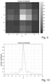
- Figures 7-14 conceptually illustrate the ability of estimating the position of an electromagnetic mirror in a SAR image with extreme accuracy.
- Figure 7 shows a first SAR image example in which there are some pixels much brighter than the background, due to the presence of an electromagnetic mirror in the imaged scene
- Figure 8 shows a three-dimensional graph of the intensities of the pixels in the SAR image of Figure 7
- Figure 9 shows an enlargement of the area of the SAR image in Figure 7 in which the electromagnetic mirror is located
- Figure 10 shows a graph of the intensities of the pixels in the SAR image area shown in Figure 9 along a single axis (i.e., axis X) of the image plane (i.e., plane XY).
- Figure 11 shows a second SAR image example in which there are some pixels much brighter than the background, due to the presence of an electromagnetic mirror in the imaged scene;
- Figure 12 shows a three-dimensional graph of the intensities of the pixels in the SAR image in Figure 11 ;
- Figure 13 shows an enlargement of the area of the SAR image in Figure 11 in which the electromagnetic mirror is located;
- Figure 14 shows a graph of the intensities of the pixels in the SAR image area shown in Figure 13 along a single axis (i.e., axis X) of the image plane (i.e., plane XY).
- measurements obtained from SAR sensors operating at different frequencies e.g., in the C, L and X bands
- different resolutions and/or embarked on different craft planes and/or satellites and/or drones, etc.
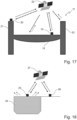
- Figures 15-18 schematically show application examples of the present invention.
- the example shown in Figure 15 regards the monitoring of overhead power lines.
- the identification of overhead power lines via SAR would depend on a vast number of conditions.
- the orientation of the overhead lines with respect to the direction from which the SAR's radar beam arrives where this orientation depends not only on the position of the SAR (for example, in the case of satellite SAR, the orbital position of the satellite on which said SAR is installed), but also on the local oscillations and rotations of the overhead lines due the effect, for example, of wind or temperature changes.
- the present invention or rather thanks to the coupling, of an integral nature, of at least one electromagnetic mirror with one of the overhead power lines, it is possible to identify and monitor said overhead lines at each orbital passage of a satellite SAR and/or at each overflight of an airborne SAR.
- FIG. 15 in which an overhead line 7 suspended between a first pylon 8 and a second pylon 9 is integrally coupled with a first electromagnetic mirror 10, while a second electromagnetic mirror 11 is integrally coupled with the second pylon 9.
- Figure 15 also shows a satellite 12 equipped with a SAR sensor that performs SAR acquisitions of the area of the earth's surface where said overhead line 7 and said pylons 8 and 9 are located.
- the overhead line 7 and the second pylon 9 are clearly visible in the SAR images acquired by the SAR sensor on board the satellite 12.
- FIG. 16 concerns building monitoring.
- a first electromagnetic mirror 13 is installed on the roof of a building 14, while a second electromagnetic mirror 15 is installed, in a fixed manner, in the vicinity of said building 14.
- Figure 16 also shows a satellite 16 equipped with a SAR sensor that performs SAR acquisitions of the area of the earth's surface where said building 14 (and therefore said first electromagnetic mirror 13) and said second electromagnetic mirror 15 are located.
- the present invention it is therefore possible to monitor buildings that are unsafe or sinking into the ground, detecting possible critical situations and automatically generating an early warning message in the event of a critical situation being detected, thereby enabling action to be taken to secure the area and safeguard the people present in the area.
- a first electromagnetic mirror 18 is integrally coupled with the deck 19 of the bridge 17, while a second electromagnetic mirror 20 is integrally coupled with a pier 21 of the bridge 17.
- Figure 17 also shows a satellite 22 equipped with a SAR sensor that performs SAR acquisitions of the area of the earth's surface where said bridge 17 is located.
- a first further electromagnetic mirror could be expediently coupled in an integral manner with the first pylon 8 and a second further electromagnetic mirror could be expediently installed, in a fixed manner, in the vicinity of the overhead line 7 and the pylons 8 and 9, in order to monitor possible movements of the pylons 8 and 9 and/or the overhead line 7 with respect to the reference position represented by the second further electromagnetic mirror installed nearby.
- a first further electromagnetic mirror could be expediently coupled in an integral manner with another pier (indicated by reference numeral 23) of the bridge 17 and a second further electromagnetic mirror could be expediently installed, in a fixed manner, in the vicinity of the bridge 17, in order to monitor possible movements of the deck 19 and/or the piers 21 and 23 with respect to the reference position represented by the second further electromagnetic mirror installed in the vicinity of the bridge 17.
- a first electromagnetic mirror 25 is installed so as to be integral with the level of the water in the reservoir 24 (for example, a floating buoy configured to function as an electromagnetic mirror could be expediently used for this purpose).
- a second electromagnetic mirror 26 is installed, in a fixed manner, in the vicinity of the reservoir 24 (for example, it could be expediently installed on the bank of said reservoir 24).
- Figure 18 also shows a satellite 27 equipped with a SAR sensor that performs SAR acquisitions of the area of the earth's surface where the reservoir 24 is located.
- Figure 19 schematically shows a monitoring, critical situation detection and early warning system (indicated as a whole by reference numeral 28) according to a preferred (but non-limitative) embodiment of the present invention.
- a SAR sensor installed on board a satellite 29 is used to acquire SAR images of an area of the earth's surface where a target 30 to be monitored is located that is coupled with one or more passive electromagnetic mirrors (for example, of the type shown in Figures 1-6 , or even of a different type).
- the target 30 can be a power line (in particular, one or more overhead lines and/or one or more pylons of said power line) as in the example in Figure 15 , a building as in the example in Figure 16 , a bridge as in the example in Figure 17 , a reservoir (for example, a natural or artificial reservoir, a channel, a river, a lake, etc.) as in the example in Figure 18 , or a generic infrastructure (for example, a dam, viaduct, oil pipeline, gas pipeline, aqueduct, etc.).
- a power line in particular, one or more overhead lines and/or one or more pylons of said power line
- a building as in the example in Figure 16
- a bridge as in the example in Figure 17
- a reservoir for example, a natural or artificial reservoir, a channel, a river, a lake, etc.
- a generic infrastructure for example, a dam, viaduct, oil pipeline, gas pipeline, aqueduct, etc.
- the satellite 29 transmits the acquired SAR images directly (as shown in Figure 19 ) and/or via a satellite communications system, i.e., via one or more communications satellites (not shown in Figure 19 for simplicity of illustration), to a ground station 31 located on the earth's surface.
- the monitoring, critical situation detection and early warning system 28 includes a control centre 32 that is connected to the ground station 31 by one or more communications networks 33, preferably one or more networks based on the Internet Protocol (IP), expediently the Internet network.
- IP Internet Protocol
- control centre 32 of the monitoring, critical situation detection and early warning system 28 includes at least one processing unit configured to:
- a plurality of satellite SAR sensors that may even have mutually different characteristics (for example, different resolutions) and/or that may acquire SAR images of the target 30 with mutually different acquisition geometries can be expediently used.
- one or more SAR sensors that are transported in flight by aerial platforms (for example, planes, drones/UAVs, helicopters, etc.) and that may even have mutually different characteristics (for example, different resolutions) and/or that may acquire SAR images of the target 30 with mutually different acquisition geometries can be expediently used as an alternative or in addition to the satellite SAR sensor(s) .
- aerial platforms for example, planes, drones/UAVs, helicopters, etc.
- mutually different characteristics for example, different resolutions
- SAR images of the target 30 with mutually different acquisition geometries can be expediently used as an alternative or in addition to the satellite SAR sensor(s) .
- Figure 20 schematically shows a monitoring, critical situation detection and early warning method (indicated as a whole by reference numeral 35) according to a preferred (but non-limitative) embodiment of the present invention.
- said monitoring, critical situation detection and early warning system 28 shown in Figure 19 is expediently configured to execute the monitoring, critical situation detection and early warning method 35 shown in Figure 20 .
- said monitoring, critical situation detection and early warning method 35 includes performing the following operations via the control centre 32 of the monitoring, critical situation detection and early warning system 28 (in particular, via the processing unit of said control centre 32) :
- the monitoring, critical situation detection and early warning method 35 also includes performing the following operations via the control and/or management centre 34 of the target 30 on which said critical situation was detected:
- the present invention enables monitoring targets that (for example, due to physical or geometrical shape) are non-visible or non-always-visible or partially visible (with performance degradation) to remote sensing systems, through the combined use of one or more satellite SAR systems and/or SAR systems transported by aerial platforms and of purely passive electromagnetic mirrors that respond like point targets and are coupled in an integral manner with the objects that it is wished to monitor.
- the present invention enables using both interferometric techniques (e.g., differential interferometry techniques) and non-interferometric techniques, as well as SAR sensors having different characteristics (e.g., different resolutions) and/or installed on board different platforms (e.g., several satellite platforms and/or several aerial platforms) and/or operating in different bands (e.g., in the X band, C band, L band, and/or other bands as well) and/or that acquire SAR images with different geometries.
- interferometric techniques e.g., differential interferometry techniques
- non-interferometric techniques e.g., different resolutions
- SAR sensors having different characteristics (e.g., different resolutions) and/or installed on board different platforms (e.g., several satellite platforms and/or several aerial platforms) and/or operating in different bands (e.g., in the X band, C band, L band, and/or other bands as well) and/or that acquire SAR images with different geometries.
- the present invention enables monitoring critical infrastructures (e.g., power lines, bridges, dams, viaducts, oil pipelines, gas pipelines, aqueducts, etc.), buildings, reservoirs (e.g., natural and/or artificial reservoirs, channels, rivers, lakes, etc.) in a highly reliable manner, allowing any critical situations to be detected, with the same reliability and in a timely manner, and to consequently provide early warnings in the event of critical situations, so as to allow taking early action in order to avoid problems or even disasters (e.g., service interruptions (as in the case of power lines, oil pipelines, gas pipelines and aqueducts), collapses (as in the case of buildings, dams, bridges and viaducts), floods (as in the case of natural and artificial reservoirs, channels, rivers, lakes and dams, etc.).
- critical infrastructures e.g., power lines, bridges, dams, viaducts, oil pipelines, gas pipelines, aqueducts, etc.
- Ref1 in no way provides for the combined use of intrinsically stable electromagnetic mirrors with imaging radars (i.e. SAR), but only contemplates the use of electromagnetic mirrors designed to provide an increase in the backscattered signal typically in a horizontal direction and at different angles.
- SAR imaging radars
- the main object of Ref1 is not that of monitoring objects via SAR images, but increasing the visibility of objects solely and exclusively for sighting radars to reduce the probability of collision at sea.
- the passive electromagnetic mirrors are considered devices suitable only for increasing the radar cross-section of targets for sighting radars, without ever considering the specific requirements/characteristics of SAR systems.
- the present invention enables monitoring non-visible or non-always-visible or partially visible objects by means of SAR remote sensing systems, purely passive electromagnetic mirrors and both interferometric and non-interferometric measurements. With regard to this, it is important to stress the point that the solution according to Ref2 makes exclusive use of active devices (with all the related limitations tied to the need of these devices for a power supply), while the present invention makes exclusive use of purely passive electromagnetic mirrors.
- Ref3 does not have the object of relative movement monitoring based on SAR images acquired with different geometries.
- the solution according to Ref3 is solely and exclusively limited to measurements based on interferometric SAR techniques.
- the present invention enables monitoring non-visible or non-always-visible or partially visible objects by means of SAR remote sensing systems, purely passive electromagnetic and both interferometric and non-interferometric measurements.
- Ref4 describes a specific electromagnetic mirror that varies its radar cross-section as the level of water varies.
- This specific electromagnetic mirror does not possess the ability to concentrate energy in ideal points, but only to modulate it according to physical parameters (i.e. water height) and therefore, unlike that envisaged in the present invention, does not allow monitoring non-visible or non-always-visible or partially visible objects by means of SAR remote sensing systems, purely passive electromagnetic mirrors and both interferometric and non-interferometric measurements.
- the present invention enables monitoring reservoirs via SAR systems by acting, unlike that described in Ref4, on the positions and/or phases of the targets and not on the backscattering brightness as taught by Ref4, in this way achieving much more accurate and reliable results.
Landscapes
- Engineering & Computer Science (AREA)
- Remote Sensing (AREA)
- Radar, Positioning & Navigation (AREA)
- Physics & Mathematics (AREA)
- Electromagnetism (AREA)
- Computer Networks & Wireless Communication (AREA)
- General Physics & Mathematics (AREA)
- Artificial Intelligence (AREA)
- Computer Vision & Pattern Recognition (AREA)
- Radar Systems Or Details Thereof (AREA)
Claims (8)
- Überwachungsverfahren, das aufweist:• integrales Koppeln eines ersten passiven elektromagnetischen Spiegels (10, 13, 18, 25) und eines gegebenen Ziels (7, 14, 17, 24, 30), das überwacht werden soll, wobei das gegebene Ziel für Radar mit synthetischer Apertur nicht sichtbar ist oder nicht immer sichtbar ist oder teilweise sichtbar ist;• integrales Koppeln eines zweiten passiven elektromagnetischen Spiegels (11, 20) und des gegebenen Ziels (9, 17, 30) oder Installieren des zweiten passiven elektromagnetischen Spiegels (15, 26) in einer gegebenen festen Position in einem gegebenen Bereich der Erdoberfläche, wo das gegebene Ziel (14, 24, 30) angeordnet ist; und• Überwachen des gegebenen Ziels (7, 9, 14, 17, 24, 30) über die Zeit durch- Erfassen von SAR-Bildern des gegebenen Bereichs der Erdoberfläche zu verschiedenen Zeiten mittels des einen oder mehrerer Radar(e) mit synthetischer Apertur, das/die an Bord eines oder mehrerer Satelliten (12, 16, 22, 27, 29) und/oder einer oder mehrerer Luftfahrzeuge installiert ist/sind,- Berechnen einer jeweiligen Entfernung zwischen dem ersten elektromagnetischen Spiegel (10, 13, 18, 25) und dem zweiten elektromagnetischen Spiegel (11, 15, 20, 26) in jedem erfassten SAR-Bild mittels einer Verarbeitungseinheit, und- Bestimmen einer wechselseitigen Verschiebung der ersten (10, 13, 18, 25) und zweiten (11, 15, 20, 26) elektromagnetischen Spiegel auf der Basis der berechneten Entfernungen zwischen den ersten (10, 13, 18, 25) und zweiten (11, 15, 20, 26) elektromagnetischen Spiegeln in den erfassten SAR-Bildern mittels der Verarbeitungseinheit,wobei kein interferometrisches Verfahren verwendet wird.
- Überwachungsverfahren nach Anspruch 1, wobei:• das gegebene Ziel eine Stromleitung ist;• der erste elektromagnetische Spiegel (10) integral mit einer Überlandleitung (7) der Stromleitung gekoppelt ist; und• der zweite elektromagnetische Spiegel (11) integral mit einem Hochspannungsmast (9) der Stromleitung gekoppelt ist oder in einer gegebenen festen Position in dem gegebenen Bereich der Erdoberfläche, wo die Überlandleitung (7) der Stromleitung angeordnet ist, installiert ist.
- Überwachungsverfahren nach Anspruch 1, wobei:• das gegebene Ziel ein Gebäude (14) ist;• der erste elektromagnetische Spiegel (13) integral mit einem ersten Teil des Gebäudes (14) gekoppelt ist; und• der zweite elektromagnetische Spiegel (15) integral mit einem zweiten Teil des Gebäudes (14) gekoppelt ist oder in einer gegebenen festen Position in dem gegebenen Bereich der Erdoberfläche, wo das Gebäude (14) angeordnet ist, installiert ist.
- Überwachungsverfahren nach Anspruch 1, wobei:• das gegebene Ziel eine Brücke (17) oder ein Viadukt ist;• der erste elektromagnetische Spiegel (18) integral mit einer Deckfläche (19) der Brücke/des Viadukts (17) gekoppelt ist; und• der zweite elektromagnetische Spiegel (20) integral mit einem Pfeiler (21) der Brücke/des Viadukts (17) gekoppelt ist oder in einer gegebenen festen Position in dem gegebenen Bereich der Erdoberfläche, wo die Brücke/das Viadukt (17) angeordnet ist, installiert ist.
- Überwachungsverfahren nach Anspruch 1, wobei das gegebene Ziel eine Infrastruktur ist, die zu der Gruppe gehört, die durch Dämme, Ölpipelines, Gaspipelines und Wasserleitungen gebildet wird.
- Überwachungsverfahren nach Anspruch 1, wobei:• das gegebene Ziel ein Speicherbecken (24) ist;• der erste elektromagnetische Spiegel (25) derart installiert wird, dass er mit einem Wasserspiegel in dem Speicherbecken (24) integral ist; und• der zweite elektromagnetische Spiegel (26) in einer gegebenen festen Position in dem gegebenen Bereich der Erdoberfläche, wo das Speicherbecken (24) angeordnet ist, installiert ist.
- Überwachungsverfahren nach Anspruch 6, wobei das Speicherbecken (24) ein natürlicher oder künstlicher Speichervorrat oder ein Kanal oder ein Fluss oder ein See ist.
- Verfahren zur Überwachung, Erkennung kritischer Situationen und Frühwarnung, das aufweist:• Ausführen des Überwachungsverfahrens nach einem der vorhergehenden Ansprüche;• Vergleichen der bestimmten wechselseitigen Verschiebung der ersten (10, 13, 18, 25) und zweiten (11, 15, 20, 26) elektromagnetischen Spiegel mit einem vordefinierten Schwellwert, der eine kritische Situation betrifft;• Erfassen einer kritischen Situation, die das überwachte gegebene Ziel (7, 9, 14, 17, 24, 30) beeinträchtigt, wenn die bestimmte wechselseitige Verschiebung der ersten (10, 13, 18, 25) und zweiten (11, 15, 20, 26) elektromagnetischen Spiegel den vordefinierten Schwellwert, der eine kritische Situation betrifft, überschreitet; und• wenn eine kritische Situation, die das überwachte gegebene Ziel (7, 9, 14, 17, 24, 30) beeinträchtigt, erfasst wird, Erzeugen einer Frühwarnung.
Applications Claiming Priority (2)
| Application Number | Priority Date | Filing Date | Title |
|---|---|---|---|
| EP16425110 | 2016-12-01 | ||
| PCT/IB2017/057579 WO2018100550A1 (en) | 2016-12-01 | 2017-12-01 | Sar-based monitoring of non-visible or non-always-visible or partially visible targets and associated monitoring, critical situation detection and early warning systems and methods |
Publications (2)
| Publication Number | Publication Date |
|---|---|
| EP3548924A1 EP3548924A1 (de) | 2019-10-09 |
| EP3548924B1 true EP3548924B1 (de) | 2024-03-13 |
Family
ID=61005852
Family Applications (1)
| Application Number | Title | Priority Date | Filing Date |
|---|---|---|---|
| EP17832332.5A Active EP3548924B1 (de) | 2016-12-01 | 2017-12-01 | Sar-basierte überwachung von unsichtbaren oder nicht immer sichtbaren oder teilweise sichtbaren zielen sowie zugehörige systeme und verfahren zur überwachung, erkennung von kritischen situationen und frühwarnung |
Country Status (3)
| Country | Link |
|---|---|
| US (1) | US11402495B2 (de) |
| EP (1) | EP3548924B1 (de) |
| WO (1) | WO2018100550A1 (de) |
Families Citing this family (6)
| Publication number | Priority date | Publication date | Assignee | Title |
|---|---|---|---|---|
| CN108983229B (zh) * | 2018-05-03 | 2022-04-19 | 电子科技大学 | 基于sar层析技术的高压输电铁塔高度及形变提取方法 |
| FR3101432B1 (fr) * | 2019-09-27 | 2021-09-03 | Airbus Helicopters | Procédé et système de détection d’obstacles filaires pour aéronef |
| JP2022127780A (ja) * | 2021-02-22 | 2022-09-01 | 株式会社グリーン&ライフ・イノベーション | 電波反射漁業用浮力体およびsar画像漁具見守りシステム |
| CN116626627B (zh) * | 2023-06-19 | 2025-04-08 | 中国科学院空天信息创新研究院 | 一种基于整体耦合成分的共极化通道不平衡定标方法 |
| CN117092631B (zh) * | 2023-10-19 | 2024-04-19 | 江苏翰林正川工程技术有限公司 | 一种输电通道施工机械目标定位与测距方法及系统 |
| CN117991258B (zh) * | 2024-04-03 | 2024-06-18 | 河海大学 | 输水建筑物过流能力监测系统 |
Citations (1)
| Publication number | Priority date | Publication date | Assignee | Title |
|---|---|---|---|---|
| EP2053423A1 (de) * | 2006-08-03 | 2009-04-29 | PASCO Corporation | Katastrophen-gegenmassnahmeunterstützungsverfahren |
Family Cites Families (4)
| Publication number | Priority date | Publication date | Assignee | Title |
|---|---|---|---|---|
| US4184155A (en) | 1978-09-22 | 1980-01-15 | The United States Of America As Represented By The Administrator Of The National Aeronautics And Space Administration | Radar target for remotely sensing hydrological phenomena |
| FR2948188B1 (fr) * | 2009-07-20 | 2011-09-09 | Soletanche Freyssinet | Procede de surveillance des mouvements d'un terrain |
| IT1401469B1 (it) * | 2010-06-28 | 2013-07-26 | Tele Rilevamento Europa T R E S R L | Apparato per la misura del movimento del suolo con immagini sar mediante almeno un riflettore di onde elettromagnetiche |
| US8902099B2 (en) * | 2010-08-16 | 2014-12-02 | Groundprobe Pty Ltd | Work area monitor |
-
2017
- 2017-12-01 EP EP17832332.5A patent/EP3548924B1/de active Active
- 2017-12-01 US US16/465,433 patent/US11402495B2/en active Active
- 2017-12-01 WO PCT/IB2017/057579 patent/WO2018100550A1/en not_active Ceased
Patent Citations (1)
| Publication number | Priority date | Publication date | Assignee | Title |
|---|---|---|---|---|
| EP2053423A1 (de) * | 2006-08-03 | 2009-04-29 | PASCO Corporation | Katastrophen-gegenmassnahmeunterstützungsverfahren |
Also Published As
| Publication number | Publication date |
|---|---|
| WO2018100550A1 (en) | 2018-06-07 |
| EP3548924A1 (de) | 2019-10-09 |
| US20200003895A1 (en) | 2020-01-02 |
| US11402495B2 (en) | 2022-08-02 |
Similar Documents
| Publication | Publication Date | Title |
|---|---|---|
| EP3548924B1 (de) | Sar-basierte überwachung von unsichtbaren oder nicht immer sichtbaren oder teilweise sichtbaren zielen sowie zugehörige systeme und verfahren zur überwachung, erkennung von kritischen situationen und frühwarnung | |
| KR101992731B1 (ko) | 선박 보조 도킹 방법과 시스템 | |
| CN105842724B (zh) | 一种船舶辅助泊岸方法和系统 | |
| KR101751020B1 (ko) | 다중 위성 기반 위험유해물질 연속 탐지 방법 및 장치 | |
| RU2712969C2 (ru) | Способ дистанционного измерения толщины льда, способ дистанционного измерения прочности льда, устройство для дистанционного измерения толщины льда, устройство для дистанционного измерения прочности льда и дистанционный измерительный модуль | |
| CN107430004B (zh) | 用于计算至少一艘船的水面速的方法和用于推导在该船的路径上每个点处的漂移向量的方法 | |
| CN103714717A (zh) | 一种基于sar数据的船舶动态跟踪与行为模式识别方法 | |
| KR102690410B1 (ko) | 해상관측 합성개구레이더 영상의 기하보정 방법 및 그 장치 | |
| US20230228868A1 (en) | Innovative method for the detection of deformed or damaged structures based on the use of single sar images | |
| CA2359252A1 (en) | Arrangement for the interferometric radar measurement according to the rosar principle | |
| Mazzanti | Displacement monitoring by terrestrial SAR interferometry for geotechnical purposes | |
| Yang et al. | Design of integrated ship monitoring system using SAR, RADAR, and AIS | |
| CN102494633A (zh) | 用于防止船舶撞击桥梁的智能探测装置 | |
| Selvakumaran et al. | Understanding InSAR measurement through comparison with traditional structural monitoring-waterloo bridge, London | |
| US20240288866A1 (en) | Assistance installation and method for assisting vessels in maneuvering at berthings | |
| Gundersen et al. | Monitoring glacier flow in Ny-Ålesund with a high temporal resolution ground-based interferometric-phased array radar | |
| Selvakumaran et al. | Using InSAR stacking techniques to predict bridge collapse due to scour | |
| Ilcev | Space remote sensing and detecting systems of oceangoing ships | |
| Yang et al. | Comparison of SUOMI NPP VIIRS SST product with Shipboard skin SST measurements in the Northwest Pacific | |
| Murcott et al. | Enhancing maritime safety with real-time air draft measurements using LiDAR technology | |
| EP3477250B1 (de) | System und verfahren zum überwachen von bauwerken des hoch- und tiefbaus und infrastrukturen, insbesondere in städtischen gebieten | |
| CA3045206A1 (en) | Synthetic aperture radar method and synthetic aperture radar system | |
| Anderson et al. | Airborne optical remote sensing of ocean currents | |
| Navas et al. | Development and validation of a multisensor system for ocean pollution detection | |
| Takewaka | Recent Coastal Remote Sensing Research in Japan |
Legal Events
| Date | Code | Title | Description |
|---|---|---|---|
| STAA | Information on the status of an ep patent application or granted ep patent |
Free format text: STATUS: UNKNOWN |
|
| STAA | Information on the status of an ep patent application or granted ep patent |
Free format text: STATUS: THE INTERNATIONAL PUBLICATION HAS BEEN MADE |
|
| PUAI | Public reference made under article 153(3) epc to a published international application that has entered the european phase |
Free format text: ORIGINAL CODE: 0009012 |
|
| STAA | Information on the status of an ep patent application or granted ep patent |
Free format text: STATUS: REQUEST FOR EXAMINATION WAS MADE |
|
| 17P | Request for examination filed |
Effective date: 20190605 |
|
| AK | Designated contracting states |
Kind code of ref document: A1 Designated state(s): AL AT BE BG CH CY CZ DE DK EE ES FI FR GB GR HR HU IE IS IT LI LT LU LV MC MK MT NL NO PL PT RO RS SE SI SK SM TR |
|
| AX | Request for extension of the european patent |
Extension state: BA ME |
|
| DAV | Request for validation of the european patent (deleted) | ||
| DAX | Request for extension of the european patent (deleted) | ||
| STAA | Information on the status of an ep patent application or granted ep patent |
Free format text: STATUS: EXAMINATION IS IN PROGRESS |
|
| 17Q | First examination report despatched |
Effective date: 20200716 |
|
| P01 | Opt-out of the competence of the unified patent court (upc) registered |
Effective date: 20230518 |
|
| GRAP | Despatch of communication of intention to grant a patent |
Free format text: ORIGINAL CODE: EPIDOSNIGR1 |
|
| STAA | Information on the status of an ep patent application or granted ep patent |
Free format text: STATUS: GRANT OF PATENT IS INTENDED |
|
| INTG | Intention to grant announced |
Effective date: 20231002 |
|
| GRAS | Grant fee paid |
Free format text: ORIGINAL CODE: EPIDOSNIGR3 |
|
| GRAA | (expected) grant |
Free format text: ORIGINAL CODE: 0009210 |
|
| STAA | Information on the status of an ep patent application or granted ep patent |
Free format text: STATUS: THE PATENT HAS BEEN GRANTED |
|
| AK | Designated contracting states |
Kind code of ref document: B1 Designated state(s): AL AT BE BG CH CY CZ DE DK EE ES FI FR GB GR HR HU IE IS IT LI LT LU LV MC MK MT NL NO PL PT RO RS SE SI SK SM TR |
|
| REG | Reference to a national code |
Ref country code: GB Ref legal event code: FG4D |
|
| REG | Reference to a national code |
Ref country code: CH Ref legal event code: EP |
|
| REG | Reference to a national code |
Ref country code: DE Ref legal event code: R096 Ref document number: 602017080047 Country of ref document: DE |
|
| REG | Reference to a national code |
Ref country code: IE Ref legal event code: FG4D |
|
| REG | Reference to a national code |
Ref country code: NL Ref legal event code: FP |
|
| PG25 | Lapsed in a contracting state [announced via postgrant information from national office to epo] |
Ref country code: LT Free format text: LAPSE BECAUSE OF FAILURE TO SUBMIT A TRANSLATION OF THE DESCRIPTION OR TO PAY THE FEE WITHIN THE PRESCRIBED TIME-LIMIT Effective date: 20240313 |
|
| REG | Reference to a national code |
Ref country code: LT Ref legal event code: MG9D |
|
| PG25 | Lapsed in a contracting state [announced via postgrant information from national office to epo] |
Ref country code: GR Free format text: LAPSE BECAUSE OF FAILURE TO SUBMIT A TRANSLATION OF THE DESCRIPTION OR TO PAY THE FEE WITHIN THE PRESCRIBED TIME-LIMIT Effective date: 20240614 |
|
| PG25 | Lapsed in a contracting state [announced via postgrant information from national office to epo] |
Ref country code: RS Free format text: LAPSE BECAUSE OF FAILURE TO SUBMIT A TRANSLATION OF THE DESCRIPTION OR TO PAY THE FEE WITHIN THE PRESCRIBED TIME-LIMIT Effective date: 20240613 Ref country code: HR Free format text: LAPSE BECAUSE OF FAILURE TO SUBMIT A TRANSLATION OF THE DESCRIPTION OR TO PAY THE FEE WITHIN THE PRESCRIBED TIME-LIMIT Effective date: 20240313 |
|
| PG25 | Lapsed in a contracting state [announced via postgrant information from national office to epo] |
Ref country code: ES Free format text: LAPSE BECAUSE OF FAILURE TO SUBMIT A TRANSLATION OF THE DESCRIPTION OR TO PAY THE FEE WITHIN THE PRESCRIBED TIME-LIMIT Effective date: 20240313 |
|
| PG25 | Lapsed in a contracting state [announced via postgrant information from national office to epo] |
Ref country code: RS Free format text: LAPSE BECAUSE OF FAILURE TO SUBMIT A TRANSLATION OF THE DESCRIPTION OR TO PAY THE FEE WITHIN THE PRESCRIBED TIME-LIMIT Effective date: 20240613 Ref country code: NO Free format text: LAPSE BECAUSE OF FAILURE TO SUBMIT A TRANSLATION OF THE DESCRIPTION OR TO PAY THE FEE WITHIN THE PRESCRIBED TIME-LIMIT Effective date: 20240613 Ref country code: LT Free format text: LAPSE BECAUSE OF FAILURE TO SUBMIT A TRANSLATION OF THE DESCRIPTION OR TO PAY THE FEE WITHIN THE PRESCRIBED TIME-LIMIT Effective date: 20240313 Ref country code: HR Free format text: LAPSE BECAUSE OF FAILURE TO SUBMIT A TRANSLATION OF THE DESCRIPTION OR TO PAY THE FEE WITHIN THE PRESCRIBED TIME-LIMIT Effective date: 20240313 Ref country code: GR Free format text: LAPSE BECAUSE OF FAILURE TO SUBMIT A TRANSLATION OF THE DESCRIPTION OR TO PAY THE FEE WITHIN THE PRESCRIBED TIME-LIMIT Effective date: 20240614 Ref country code: FI Free format text: LAPSE BECAUSE OF FAILURE TO SUBMIT A TRANSLATION OF THE DESCRIPTION OR TO PAY THE FEE WITHIN THE PRESCRIBED TIME-LIMIT Effective date: 20240313 Ref country code: ES Free format text: LAPSE BECAUSE OF FAILURE TO SUBMIT A TRANSLATION OF THE DESCRIPTION OR TO PAY THE FEE WITHIN THE PRESCRIBED TIME-LIMIT Effective date: 20240313 Ref country code: BG Free format text: LAPSE BECAUSE OF FAILURE TO SUBMIT A TRANSLATION OF THE DESCRIPTION OR TO PAY THE FEE WITHIN THE PRESCRIBED TIME-LIMIT Effective date: 20240313 |
|
| REG | Reference to a national code |
Ref country code: AT Ref legal event code: MK05 Ref document number: 1666264 Country of ref document: AT Kind code of ref document: T Effective date: 20240313 |
|
| PG25 | Lapsed in a contracting state [announced via postgrant information from national office to epo] |
Ref country code: SE Free format text: LAPSE BECAUSE OF FAILURE TO SUBMIT A TRANSLATION OF THE DESCRIPTION OR TO PAY THE FEE WITHIN THE PRESCRIBED TIME-LIMIT Effective date: 20240313 Ref country code: LV Free format text: LAPSE BECAUSE OF FAILURE TO SUBMIT A TRANSLATION OF THE DESCRIPTION OR TO PAY THE FEE WITHIN THE PRESCRIBED TIME-LIMIT Effective date: 20240313 |
|
| PG25 | Lapsed in a contracting state [announced via postgrant information from national office to epo] |
Ref country code: IS Free format text: LAPSE BECAUSE OF FAILURE TO SUBMIT A TRANSLATION OF THE DESCRIPTION OR TO PAY THE FEE WITHIN THE PRESCRIBED TIME-LIMIT Effective date: 20240713 |
|
| PG25 | Lapsed in a contracting state [announced via postgrant information from national office to epo] |
Ref country code: PT Free format text: LAPSE BECAUSE OF FAILURE TO SUBMIT A TRANSLATION OF THE DESCRIPTION OR TO PAY THE FEE WITHIN THE PRESCRIBED TIME-LIMIT Effective date: 20240715 Ref country code: SM Free format text: LAPSE BECAUSE OF FAILURE TO SUBMIT A TRANSLATION OF THE DESCRIPTION OR TO PAY THE FEE WITHIN THE PRESCRIBED TIME-LIMIT Effective date: 20240313 |
|
| PG25 | Lapsed in a contracting state [announced via postgrant information from national office to epo] |
Ref country code: CZ Free format text: LAPSE BECAUSE OF FAILURE TO SUBMIT A TRANSLATION OF THE DESCRIPTION OR TO PAY THE FEE WITHIN THE PRESCRIBED TIME-LIMIT Effective date: 20240313 Ref country code: EE Free format text: LAPSE BECAUSE OF FAILURE TO SUBMIT A TRANSLATION OF THE DESCRIPTION OR TO PAY THE FEE WITHIN THE PRESCRIBED TIME-LIMIT Effective date: 20240313 |
|
| PG25 | Lapsed in a contracting state [announced via postgrant information from national office to epo] |
Ref country code: AT Free format text: LAPSE BECAUSE OF FAILURE TO SUBMIT A TRANSLATION OF THE DESCRIPTION OR TO PAY THE FEE WITHIN THE PRESCRIBED TIME-LIMIT Effective date: 20240313 |
|
| PG25 | Lapsed in a contracting state [announced via postgrant information from national office to epo] |
Ref country code: PL Free format text: LAPSE BECAUSE OF FAILURE TO SUBMIT A TRANSLATION OF THE DESCRIPTION OR TO PAY THE FEE WITHIN THE PRESCRIBED TIME-LIMIT Effective date: 20240313 |
|
| PG25 | Lapsed in a contracting state [announced via postgrant information from national office to epo] |
Ref country code: SK Free format text: LAPSE BECAUSE OF FAILURE TO SUBMIT A TRANSLATION OF THE DESCRIPTION OR TO PAY THE FEE WITHIN THE PRESCRIBED TIME-LIMIT Effective date: 20240313 |
|
| PG25 | Lapsed in a contracting state [announced via postgrant information from national office to epo] |
Ref country code: SM Free format text: LAPSE BECAUSE OF FAILURE TO SUBMIT A TRANSLATION OF THE DESCRIPTION OR TO PAY THE FEE WITHIN THE PRESCRIBED TIME-LIMIT Effective date: 20240313 Ref country code: SK Free format text: LAPSE BECAUSE OF FAILURE TO SUBMIT A TRANSLATION OF THE DESCRIPTION OR TO PAY THE FEE WITHIN THE PRESCRIBED TIME-LIMIT Effective date: 20240313 Ref country code: RO Free format text: LAPSE BECAUSE OF FAILURE TO SUBMIT A TRANSLATION OF THE DESCRIPTION OR TO PAY THE FEE WITHIN THE PRESCRIBED TIME-LIMIT Effective date: 20240313 Ref country code: PT Free format text: LAPSE BECAUSE OF FAILURE TO SUBMIT A TRANSLATION OF THE DESCRIPTION OR TO PAY THE FEE WITHIN THE PRESCRIBED TIME-LIMIT Effective date: 20240715 Ref country code: PL Free format text: LAPSE BECAUSE OF FAILURE TO SUBMIT A TRANSLATION OF THE DESCRIPTION OR TO PAY THE FEE WITHIN THE PRESCRIBED TIME-LIMIT Effective date: 20240313 Ref country code: IS Free format text: LAPSE BECAUSE OF FAILURE TO SUBMIT A TRANSLATION OF THE DESCRIPTION OR TO PAY THE FEE WITHIN THE PRESCRIBED TIME-LIMIT Effective date: 20240713 Ref country code: EE Free format text: LAPSE BECAUSE OF FAILURE TO SUBMIT A TRANSLATION OF THE DESCRIPTION OR TO PAY THE FEE WITHIN THE PRESCRIBED TIME-LIMIT Effective date: 20240313 Ref country code: CZ Free format text: LAPSE BECAUSE OF FAILURE TO SUBMIT A TRANSLATION OF THE DESCRIPTION OR TO PAY THE FEE WITHIN THE PRESCRIBED TIME-LIMIT Effective date: 20240313 Ref country code: AT Free format text: LAPSE BECAUSE OF FAILURE TO SUBMIT A TRANSLATION OF THE DESCRIPTION OR TO PAY THE FEE WITHIN THE PRESCRIBED TIME-LIMIT Effective date: 20240313 |
|
| REG | Reference to a national code |
Ref country code: DE Ref legal event code: R097 Ref document number: 602017080047 Country of ref document: DE |
|
| PG25 | Lapsed in a contracting state [announced via postgrant information from national office to epo] |
Ref country code: DK Free format text: LAPSE BECAUSE OF FAILURE TO SUBMIT A TRANSLATION OF THE DESCRIPTION OR TO PAY THE FEE WITHIN THE PRESCRIBED TIME-LIMIT Effective date: 20240313 |
|
| PLBE | No opposition filed within time limit |
Free format text: ORIGINAL CODE: 0009261 |
|
| STAA | Information on the status of an ep patent application or granted ep patent |
Free format text: STATUS: NO OPPOSITION FILED WITHIN TIME LIMIT |
|
| PG25 | Lapsed in a contracting state [announced via postgrant information from national office to epo] |
Ref country code: DK Free format text: LAPSE BECAUSE OF FAILURE TO SUBMIT A TRANSLATION OF THE DESCRIPTION OR TO PAY THE FEE WITHIN THE PRESCRIBED TIME-LIMIT Effective date: 20240313 |
|
| 26N | No opposition filed |
Effective date: 20241216 |
|
| PGFP | Annual fee paid to national office [announced via postgrant information from national office to epo] |
Ref country code: DE Payment date: 20241227 Year of fee payment: 8 |
|
| PG25 | Lapsed in a contracting state [announced via postgrant information from national office to epo] |
Ref country code: SI Free format text: LAPSE BECAUSE OF FAILURE TO SUBMIT A TRANSLATION OF THE DESCRIPTION OR TO PAY THE FEE WITHIN THE PRESCRIBED TIME-LIMIT Effective date: 20240313 |
|
| PG25 | Lapsed in a contracting state [announced via postgrant information from national office to epo] |
Ref country code: MC Free format text: LAPSE BECAUSE OF FAILURE TO SUBMIT A TRANSLATION OF THE DESCRIPTION OR TO PAY THE FEE WITHIN THE PRESCRIBED TIME-LIMIT Effective date: 20240313 |
|
| REG | Reference to a national code |
Ref country code: CH Ref legal event code: PL |
|
| PG25 | Lapsed in a contracting state [announced via postgrant information from national office to epo] |
Ref country code: LU Free format text: LAPSE BECAUSE OF NON-PAYMENT OF DUE FEES Effective date: 20241201 |
|
| REG | Reference to a national code |
Ref country code: BE Ref legal event code: MM Effective date: 20241231 |
|
| PG25 | Lapsed in a contracting state [announced via postgrant information from national office to epo] |
Ref country code: BE Free format text: LAPSE BECAUSE OF NON-PAYMENT OF DUE FEES Effective date: 20241231 |
|
| PG25 | Lapsed in a contracting state [announced via postgrant information from national office to epo] |
Ref country code: CH Free format text: LAPSE BECAUSE OF NON-PAYMENT OF DUE FEES Effective date: 20241231 |
|
| PG25 | Lapsed in a contracting state [announced via postgrant information from national office to epo] |
Ref country code: IE Free format text: LAPSE BECAUSE OF NON-PAYMENT OF DUE FEES Effective date: 20241201 |
|
| PGFP | Annual fee paid to national office [announced via postgrant information from national office to epo] |
Ref country code: GB Payment date: 20251223 Year of fee payment: 9 |
|
| PGFP | Annual fee paid to national office [announced via postgrant information from national office to epo] |
Ref country code: IT Payment date: 20251117 Year of fee payment: 9 |
|
| PGFP | Annual fee paid to national office [announced via postgrant information from national office to epo] |
Ref country code: NL Payment date: 20251222 Year of fee payment: 9 Ref country code: FR Payment date: 20251223 Year of fee payment: 9 |