EP3367137A2 - Systeme und verfahren zum sammeln und verteilen von kritischen wetterereignisinformationen - Google Patents
Systeme und verfahren zum sammeln und verteilen von kritischen wetterereignisinformationen Download PDFInfo
- Publication number
- EP3367137A2 EP3367137A2 EP18157979.8A EP18157979A EP3367137A2 EP 3367137 A2 EP3367137 A2 EP 3367137A2 EP 18157979 A EP18157979 A EP 18157979A EP 3367137 A2 EP3367137 A2 EP 3367137A2
- Authority
- EP
- European Patent Office
- Prior art keywords
- weather
- consumer
- data
- critical
- vehicle
- Prior art date
- Legal status (The legal status is an assumption and is not a legal conclusion. Google has not performed a legal analysis and makes no representation as to the accuracy of the status listed.)
- Granted
Links
Images


Classifications
-
- G—PHYSICS
- G08—SIGNALLING
- G08G—TRAFFIC CONTROL SYSTEMS
- G08G5/00—Traffic control systems for aircraft
- G08G5/20—Arrangements for acquiring, generating, sharing or displaying traffic information
- G08G5/26—Transmission of traffic-related information between aircraft and ground stations
-
- G—PHYSICS
- G01—MEASURING; TESTING
- G01C—MEASURING DISTANCES, LEVELS OR BEARINGS; SURVEYING; NAVIGATION; GYROSCOPIC INSTRUMENTS; PHOTOGRAMMETRY OR VIDEOGRAMMETRY
- G01C21/00—Navigation; Navigational instruments not provided for in groups G01C1/00 - G01C19/00
- G01C21/20—Instruments for performing navigational calculations
-
- G—PHYSICS
- G01—MEASURING; TESTING
- G01C—MEASURING DISTANCES, LEVELS OR BEARINGS; SURVEYING; NAVIGATION; GYROSCOPIC INSTRUMENTS; PHOTOGRAMMETRY OR VIDEOGRAMMETRY
- G01C23/00—Combined instruments indicating more than one navigational value, e.g. for aircraft; Combined measuring devices for measuring two or more variables of movement, e.g. distance, speed or acceleration
-
- G—PHYSICS
- G01—MEASURING; TESTING
- G01S—RADIO DIRECTION-FINDING; RADIO NAVIGATION; DETERMINING DISTANCE OR VELOCITY BY USE OF RADIO WAVES; LOCATING OR PRESENCE-DETECTING BY USE OF THE REFLECTION OR RERADIATION OF RADIO WAVES; ANALOGOUS ARRANGEMENTS USING OTHER WAVES
- G01S13/00—Systems using the reflection or reradiation of radio waves, e.g. radar systems; Analogous systems using reflection or reradiation of waves whose nature or wavelength is irrelevant or unspecified
- G01S13/88—Radar or analogous systems specially adapted for specific applications
- G01S13/95—Radar or analogous systems specially adapted for specific applications for meteorological use
- G01S13/953—Radar or analogous systems specially adapted for specific applications for meteorological use mounted on aircraft
-
- G—PHYSICS
- G01—MEASURING; TESTING
- G01W—METEOROLOGY
- G01W1/00—Meteorology
-
- G—PHYSICS
- G01—MEASURING; TESTING
- G01W—METEOROLOGY
- G01W1/00—Meteorology
- G01W1/02—Instruments for indicating weather conditions by measuring two or more variables, e.g. humidity, pressure, temperature, cloud cover or wind speed
- G01W1/06—Instruments for indicating weather conditions by measuring two or more variables, e.g. humidity, pressure, temperature, cloud cover or wind speed giving a combined indication of weather conditions
-
- G—PHYSICS
- G01—MEASURING; TESTING
- G01W—METEOROLOGY
- G01W1/00—Meteorology
- G01W1/08—Adaptations of balloons, missiles, or aircraft for meteorological purposes; Radiosondes
-
- G—PHYSICS
- G08—SIGNALLING
- G08G—TRAFFIC CONTROL SYSTEMS
- G08G5/00—Traffic control systems for aircraft
- G08G5/20—Arrangements for acquiring, generating, sharing or displaying traffic information
- G08G5/21—Arrangements for acquiring, generating, sharing or displaying traffic information located onboard the aircraft
-
- G—PHYSICS
- G08—SIGNALLING
- G08G—TRAFFIC CONTROL SYSTEMS
- G08G5/00—Traffic control systems for aircraft
- G08G5/20—Arrangements for acquiring, generating, sharing or displaying traffic information
- G08G5/22—Arrangements for acquiring, generating, sharing or displaying traffic information located on the ground
-
- G—PHYSICS
- G08—SIGNALLING
- G08G—TRAFFIC CONTROL SYSTEMS
- G08G5/00—Traffic control systems for aircraft
- G08G5/20—Arrangements for acquiring, generating, sharing or displaying traffic information
- G08G5/25—Transmission of traffic-related information between aircraft
-
- G—PHYSICS
- G08—SIGNALLING
- G08G—TRAFFIC CONTROL SYSTEMS
- G08G5/00—Traffic control systems for aircraft
- G08G5/30—Flight plan management
- G08G5/32—Flight plan management for flight plan preparation
-
- G—PHYSICS
- G08—SIGNALLING
- G08G—TRAFFIC CONTROL SYSTEMS
- G08G5/00—Traffic control systems for aircraft
- G08G5/50—Navigation or guidance aids
-
- G—PHYSICS
- G08—SIGNALLING
- G08G—TRAFFIC CONTROL SYSTEMS
- G08G5/00—Traffic control systems for aircraft
- G08G5/50—Navigation or guidance aids
- G08G5/53—Navigation or guidance aids for cruising
-
- G—PHYSICS
- G08—SIGNALLING
- G08G—TRAFFIC CONTROL SYSTEMS
- G08G5/00—Traffic control systems for aircraft
- G08G5/50—Navigation or guidance aids
- G08G5/55—Navigation or guidance aids for a single aircraft
-
- G—PHYSICS
- G08—SIGNALLING
- G08G—TRAFFIC CONTROL SYSTEMS
- G08G5/00—Traffic control systems for aircraft
- G08G5/70—Arrangements for monitoring traffic-related situations or conditions
- G08G5/76—Arrangements for monitoring traffic-related situations or conditions for monitoring atmospheric conditions
-
- G—PHYSICS
- G01—MEASURING; TESTING
- G01W—METEOROLOGY
- G01W1/00—Meteorology
- G01W2001/006—Main server receiving weather information from several sub-stations
Definitions
- Improved weather gathering systems allow for the sharing of real-time weather data as detected by an onboard weather radar (further referred as producer) to a ground center.
- This weather data may get processed (applying data fusion & prediction algorithms) and unified with other weather data at the ground station.
- This unified weather data may be up-linked to a subscribed aircraft (further referred as consumer).
- this system allows for the gathering and collating of weather information from a plurality of resources.
- a request for weather information is initiated from the ground (e.g. a global data center) and in response, an onboard weather radar sends the applicable weather data that has been requested.
- This data gets processed on the ground and further gets up-linked to the consumer aircraft where it is displayed on cockpit displays, electronic flight bag or tablet computer as an overlay.
- the up-link request may be a request for a particular weather phenomenon such as, hail, lightning, turbulence, wind shear etc. or it may be combination of one or more such weather phenomenon.
- a producer responds back to the ground data center with the data that has been requested.
- ground data center prediction algorithms heavily rely on the accuracy and timeliness of the data as downlinked from the producer aircraft. The more current the data, the more accurate the weather prediction.
- significant ground data center processing is required. The processing needs to identify producers that could generate relevant data, make requests to those particular aircraft, get the data down-linked, fuse it and up-link to consumers. This processing is time consuming and could introduce latencies in providing data to the consumers.
- An alternate approach could be where producer aircraft down-link weather data continuously to a ground center without depending on any of the ground requests (i.e. streaming).
- the data-link costs that incur in such type of continuous down-link can be large, especially keeping in view the volume of data that gets down-linked.
- Embodiments provide methods and systems for gathering and dispersing critical weather events to a consumer vehicle.
- a method of gathering and distributing critical weather event information includes monitoring for critical weather events based on defined critical weather event thresholds with an onboard producer weather detection unit of at least one producer vehicle.
- Current time stamp and geolocation information are associated with each detected critical weather event.
- the detected critical weather event, associated time stamp and geolocation information are communicated to a base station.
- the detected critical weather event is fused with other weather data at the base station to produce a unified weather event image that includes the detected critical weather event.
- Prediction algorithms are applied to the unified weather event image at the base station to produce predicted weather data including the detected critical weather event parsed into predefined grid cells of a geo-spatial grid.
- the predicted weather data with the detected critical weather event is up-linked to a consumer vehicle anticipated to travel within at least one grid cell of the geo-spatial grid associated with the predicted weather data.
- critical weather event thresholds are dynamically reconfigured at the producer vehicle based at least in part on consumption needs of the consumer vehicle.
- a method of gathering and distributing critical weather event information includes monitoring at least one sensor of at least one producer for critical weather events based on critical weather event thresholds.
- a geo-location tag and a time stamp is attached to monitored critical weather events by the at least one producer.
- Critical weather events are down-linked from the at least one producer vehicle to a base station.
- the detected critical weather event are fused with other weather data at the base station to produce a unified weather event image including the detected critical weather event.
- the unified weather event image is applied to a geo-spatial grid over a travel area.
- the geo-spatial grid has a plurality of grid cells.
- a bounding box is determined for a consuming vehicle. The size of the bounding box is configured based on consumption needs of the consumer vehicle.
- the bounding box is in the immediate travel path of consumer vehicle represented on the geo-spatial grid.
- a critical weather event is up-linked to the consumer aircraft when the bounding box overlaps at least one grid cell of the geo-spatial grid
- a base station to gather and distribute critical weather event information includes a data communication manager, at least one memory and at least one processor.
- the data communication manager is configured to communicate with at least one producer vehicle and at least one consumer vehicle.
- the at least one memory is configured to store at least operating instructions and critical weather alert information.
- the at least one processor is configured to execute the operating instructions.
- the base station further includes a producer domain that is implemented by the at least one processor.
- the producer domain is in communication with the data communication manager.
- the producer domain includes a weather data fusion and prediction element that is configured to fuse critical weather event data communicated from the at least one producer vehicle with other weather gathering sources to generate a unified weather event image and forecast information for an area of travel that is overlaid with a geo-spatial grid.
- the geo-spatial grid having a plurality of grid cells. Each grid cell associated with a location in the area of travel and an associated portion of the unified weather event image and forecast information.
- the producer domain configured to store the unified weather event image and forecast information and geo-spatial grid in the at least one memory.
- the base station further includes a consumer domain.
- the consumer domain is implemented by the at least one processor and is in communication with the data communication manager.
- the consumer domain includes a consumer data processing element that is configured to determine a consumer vehicle location and travel path information for the at least one consumer vehicle.
- the consumer data processing element is further configured to determine a bounding box for the at least one consumer vehicle. The size of the bounding box being configurable based on consumption needs of the at least one consumer vehicle.
- the bounding box being in an immediate travel path of the at least one consumer vehicle represented on the geo-spatial grid.
- the consumer data processing element is configured to identify identifying critical weather events for the at least one consumer vehicle by determining an overlapping of the bounding box of the at least one consumer vehicle with at least one grid cell of the geo-spatial grid associated with critical weather event data.
- the consumer domain further being configured to generate a critical weather event message to be sent to the at least consumer vehicle via the communication manager upon determination of the overlap.
- Embodiments of the present invention provide systems and methods that allows a ground data center to automatically identify and trigger critical weather alerts to a consumer vehicle, such as a consumer aircraft.
- a communication system 100 includes a ground data center 102.
- the ground data center 102 includes a processing station 104 with one or more processors and memories.
- the memory holds one or more data bases 106.
- the communication system 100 further includes a plurality of producer aircrafts 108-1 through 108-n that are in communication with the ground data center 102. As discussed in detail below, the producer aircrafts 108-1 through 108-n provide information such as weather information requested by the ground data center 102.
- the ground data center processes gathered information from the producer aircrafts 108-1 through 108-n and other sources and provides it to the consumer aircraft 110 as discussed in detail below.
- this communication system is described as applying to an aircraft communication system other types of communication systems benefiting from this type of information system are contemplated, such as, but not limited to, other types of vehicle communication systems.
- the ground data center may generally referred to as a base station 102
- the producer aircrafts can generally referred to as producer vehicles 108-1 through 108-n
- the consumer aircraft may generally referred to as a consumer vehicle 110.
- the processing station 104 may include any one or more of a processor, microprocessor, a digital signal processor (DSP), an application specific integrated circuit (ASIC), a field program gate array (FPGA), or equivalent discrete or integrated logic circuitry.
- processing station 104 may include multiple components, such as any combination of one or more microprocessors, one or more controllers, one or more DSPs, one or more ASICs, one or more FPGAs, as well as other discrete or integrated logic circuitry.
- the functions attributed to the processing station 104 herein may be embodied as software, firmware, hardware or any combination thereof.
- Memories within the processing station 104 may include computer-readable operating instructions that, when executed by the processing station 104 provides functions of the communication system 100.
- the computer readable instructions may be encoded within the memory.
- Memory may comprise computer readable storage media including any volatile, nonvolatile, magnetic, optical, or electrical media, such as, but not limited to, a random access memory (RAM), read-only memory (ROM), non-volatile RAM (NVRAM), electrically-erasable programmable ROM (EEPROM), flash memory, or any other storage medium.
- RAM random access memory
- ROM read-only memory
- NVRAM non-volatile RAM
- EEPROM electrically-erasable programmable ROM
- flash memory or any other storage medium.
- Embodiment systems allow management of data pertaining to registered consumer aircrafts (flight plan, time of departure, time of arrival, wing load capacity etc.) via a database 106.
- Example systems allow updates to the current location of the consumer aircraft 110 on a periodic basis, so as to define an updated region of interest for the consumer aircraft 110. In absence of periodic updates, an updated region of interest may be calculated based on the probabilistic position of the consumer aircraft 110. Corrections to the prediction of region of interest may be made when position updates are shared by the consumer aircraft 110.
- Embodiments implement a method to decode weather data as down-linked from producer aircrafts 108-1 through 108-n, process the data (applying data fusion algorithms) and store the geo-spatially resolved weather data into a data base 106 (into the associated pre-defined geo-spatial grids). Attributes get associated with the critical weather data.
- Example attributes include position information (latitude, longitude & altitude), a Universal Time Constant (UTC) data, confidence level with which the data has been detected (which may depend on how close the data has been observed from the producer aircraft 108-1 through 108-n).
- Embodiments allow dynamic reconfiguration of the configurable file containing weather thresholds of interest (available in the producer aircraft) via a request in real time.
- Embodiments further allow for identification of relevant producer aircraft 108-1 through 108-n that can supply the required weather information based on the consumption need of the consumer aircraft.
- embodiments enable specific weather hazard features (such as the ability to re-configuring the configuration file of a producer aircraft such that it shall downlink only the configured parameters) based on needs of a consumer aircraft 110. The needs may depend on the current phase of a fight. For example, predictive wind shear is needed while a consumer is flying near to ground and not in cruise mode. Hail/lightning information is relevant when the consumer aircraft 110 is in cruise mode etc.
- appropriate threshold limits are configured for critical weather data depending on the consumer aircraft 110 type/geo-graphical positions.
- embodiments may configure the periodicity of processing and downlinking of the critical weather data. For example, data may be processed at every 20nm, 40 nm, 80 nm, 160nm, 320nm or etc.
- a method to process and check for the presence of critical weather events (event classification based on consumer aircraft need, within the downlinked weather from various producer aircraft 108-1 through 108-n) in the regions of overlap between the region of interest pertaining to that of a consumer aircraft 110 (which is configurable, for example 80nm ahead on the flight path from the current location of the consumer aircraft 110) and the pre-defined grid cells of a geo-spatial grid is provided in an embodiment.
- a method to trigger auto up-link messages to the identified consumer aircraft 110, upon detecting the presence of any of the critical weather events in the region of interest is provided in an embodiment.
- system embodiments allow for the determination of the criticality of the weather event (dynamic event classification) based on the type of the consumer aircraft 110 (wing load capability) and its flight context (flight phase, region in which the flight is flying etc.).
- a system allows producer aircraft 108-1 through 108-n to share information pertaining to weather with the ground data center 102, upon detecting the occurrence of any pre-defined critical weather event.
- the system provides a trigger for an automatic down-link upon detection of such critical weather events. Every such event or weather update may trigger execution of the data fusion and weather predicting algorithms that is running in the ground data center 102.
- embodiments store data into the onboard system of the produce aircrafts 108-1 through 108-n in case there isn't any communication link available at the current time.
- Embodiments store the data along with a time stamp UTC and once the link is available, the stored is down-linked to the ground station center 102.
- a ground data center 102 to fetch and auto up-link the critical weather event data as applicable (based on the flight plan and wing load) to registered consumer aircrafts 110.
- Figure 1 illustrates one registered consumer aircraft 110, any number of registered consumer aircraft 100 may be provided the critical weather event data as needed. Hence, a plurality of registered consumer aircraft 100 can be serviced.
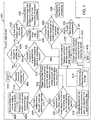
- FIG. 2 a high level functional block diagram of an event based weather data exchange system 200 of an embodiment, from the context of a producer aircraft 108, ground data center 102 and consumer aircraft 110 is provided.
- Each functional block performs a specific task to achieve the end objective of sharing the critical weather events (as detected by the producer aircraft 108) to the ground data center 102 and further to the consumer aircraft 110.
- some blocks of the event based weather data exchange system 200 may include one or more processors that implement instructions stored in one or more memories.
- the one or more memories may be used to store information.
- the producer aircraft 108 includes a pre-defined configurable weather events block 204. Included in block 204 is a configurable file via which a user can define which type of weather detections are to be classified as critical weather events. The parameters are defined based on the capabilities of an onboard weather detection unit as not all weather detection units have all the features enabled. This also allows the user to configure threshold values for each of the weather phenomenon, beyond which they get classified as critical weather events.
- Example thresholds include, but are not limited to, thresholds for precipitation levels (that are above a particular dBz), threshold values for the detected peak and average Eddy Dissipation Rate (EDR), thresholds for turbulence and threshold values for the total number of hail and or lightning events.
- the system allows a mechanism to update a configurable file of the pre-defined configurable weather events at block 204 via a secure up-link message from the ground data center.
- the ground data center 102 shall determine which weather phenomenon could be treated as critical and also determines the respective threshold values to be checked for.
- the ground data center 102 can then send the list of critical weather events to the producer aircraft 108 (via up-link request to all producer aircraft 108-1 through 108-n) which would then be used for re-configuring the weather data configurable file at block 204.
- producer aircraft 108 filters and provides only weather data that has been requested by the ground data center 102. This helps reduce the bandwidth utilization by restricting downlink of only the weather data that is needed by a consumer 110.
- the producer aircraft 108 also includes a weather detection element block 208.
- the weather detection element block includes one or more onboard sensors that are used for detecting the weather prevailing ahead of the producer aircraft 108. The detected weather gets portrayed on an onboard display 216 as seen by the pilot. Also, the data detected is made available to a weather event processing element block 210 for further processing.
- the weather event processing element block 210 processes the weather data (available from the weather detection element block 208) and determines if any of the listed pre-defined configurable weather events from block 204 are beyond the threshold limits. Ones beyond the threshold limits are classified as critical weather events.
- the weather event processing element block 210 is also responsible for associating a current time stamp UTC to all such critical weather events in embodiment.
- geo-reference tags latitude, longitude & altitude
- the data required for geo-reference tags is obtained from the onboard sensors (such as, but not limited to, GPS/INS/RadAlt etc.) that are part of the aircraft location reference block 206.
- the producer aircraft 108 also includes a weather event repository bock 212.
- This is a storage element (database) that is available onboard the aircraft used for recording the critical weather events. All the critical weather events and associated geo-spatial tags and corresponding UTC tags are stored for any future data retrieval in the weather event repository block 212.
- Ground downlink triggering and processing element at block 214 is used to check for the available critical weather events as stored in the weather event repository 212, and if available, trigger the weather data downlink to the ground data center 102 via the available onboard data communication manager 218.
- the Ground downlink triggering and processing element 214 may have built-in intelligence to constantly compare and determine whether a particular critical event has been down-linked or not (keeps track of events downlinked). Only delta changes in information gets downlinked in an embodiment to minimize communication downlinks.
- the ground data center 102 functional blocks are segregated based on whether they are performed in the producer domain 220 or the consumer domain 230 as illustrated in Figure 2 .
- the ground data center 102 includes an event resolution and processing element 228.
- the functionality of event resolution and processing element 228 block is to autonomously process the downlinked data when downlink data is available from any registered producer aircraft.
- the event resolution and processing element 228, identifies all critical weather events and translates each critical weather event into predefined formats (based on associated latitude, longitude, altitude, UTC, data confidence level). This module may be capable of processing the data in parallel as received from one or multiple producer aircraft.
- the producer domain 220 of the ground data center 102 further includes a weather data fusion and prediction element 226.
- the weather data fusion and prediction element 226 fuses processed critical weather data information as obtained from the event resolution and processing element 228 and any other source (ground based weather data) such that a unified image of weather event is produced. Once fused, based on the availability of data, prediction algorithms in the weather data fusion and prediction element 226 get executed in order to forecast any of the weather related phenomenon.
- the fused and predicted weather data is stored in a predefined grid (partitioned geo-spatially grid) with a geo-spatially resolved weather data storage block 224.
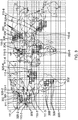
- FIG. 3 An example of a geo-spatial grid 300 that covers an area of travel, which is the world in this example, is illustrated in Figure 3 .
- fused and predicted weather data is associated with one or more grid cell locations of the geo-spatial grid 300 and is stored in memory, such as data base 106, in the geo-spatially resolved weather data storage 224. Any new updates pertaining to any of the weather events overwrite the existing information in embodiments, such that the latest weather data can be made available at any given point of time.
- the producer domain 220 of the ground data center 102 further includes a weather data retrieval element 222.
- the functionality of the weather data retrieval element 222 is to retrieve the critical weather information as requested by a consumer aircraft.
- the weather data retrieval element 222 runs a query in the geo-spatially resolved weather data storage 224. The request is based on one or more grid cell locations in the geo-spatial grid 300 associated with the area of travel of the consumer aircraft 110.
- the consumer domain 230 of the ground data center 102 includes two modes in the embodiment of Figure 2 .
- a first mode the consumer domain 230 receives the current location of the consumer aircraft 110 and then checks for presence of any of the critical weather events of relevance to the consumer aircraft 110 (based on its flight plan) and if any such events are available.
- the consumer domain 230 in the first mode triggers an automatic weather alert message (critical weather event data) when the presence of a critical weather event is of relevance to the consumer aircraft 110 is detected.
- the ground data center 102 accepts specific requests (e.g. weather request at a specific location) from a consumer aircraft 110, validates the requests, retrieves the relevant information from a ground data repository (i.e. the geospatially resolved weather data storage 224), and then up-links the information to the requesting consumer aircraft 110.
- specific requests e.g. weather request at a specific location
- a ground data repository i.e. the geospatially resolved weather data storage 224
- the consumer domain 230 of the ground data center 102 includes a weather request/position data validation element 236.
- the weather request/position data validation element 236 validates the location references (current geo-spatial coordinates) as shared by the consumer aircraft 110.
- the weather request/position data validation element 236 validates the weather requests from the consumer aircraft 110. Once validated and authorized, the data gets processed further by the consumer data processing element 232.
- the functionality of the consumer data processing element 232 is to get the consumer aircraft current location information, identify geo-spatial areas of interest (bounding box based at least in part on consumer consumption needs, aircraft current location and the flight path) that intersect with predefined grid cells (overlaid across an area of travel) and look for the presence of any of the critical weather events.
- the consumer data processing element 232 is responsible for fetching the relevant data as requested (specific weather requests, e.g. pertaining to a specific geo-spatial location) and information pertaining to consumer aircraft (like flight path, time of departure, time of arrival, wing load capabilities etc.) from a consumer database 106. These parameters are further used by the consumer data processing element 232 in determining critical weather events that are relevant to a particular consumer aircraft 110.
- the consumer data processing element 232 is also responsible for associating geo-spatial tags and the time stamp UTC for the identified weather events.
- a three dimensional geo-spatial grid latitude, longitude & altitude holds the critical weather data as obtained from the producer aircraft 108.
- the consumer domain 230 of the ground data center 102 also includes a consumer data up-link trigger element 238.
- the consumer data up-link trigger element 238 initiates an up-fink trigger to the identified consumer aircraft 110 upon detection of any of the critical weather event that is applicable for that particular consumer aircraft 110.
- the consumer domain 230 of the ground data center 102 further includes a weather event file manager 234.
- the weather event file manager 234 determines which weather data could be classified as critical based on the wing load capabilities of the registered consumer aircraft 110. Based on this, a special up-link request may be generated and broadcasted to all the producer aircraft 108 via data communication manager 240 and communication channel 202 to update their respective configurable weather events file such that they start filtering only for such critical weather events and down-link them as and when they get detected.
- the consumer aircraft 110 is illustrated in Figure 2 as having a flight context builder 252.
- the flight context builder 252 periodically shares the then current location of the consumer aircraft 110 with the ground data center 102 via data communication manager 250 and communication channel 202.
- the flight context builder 252 is responsible for generating any of the special weather related requests pertaining to a specific location (based on the context of the flight, for example, take-off, cruise, landing, emergency situation, etc.).
- the required flight parameters are obtained from the onboard systems such as, but not limited to, an air data computer, a flight management system, a flight control system and on board flight sensors 260, such as, but not limited to, radio altimeter etc.
- the consumer aircraft 110 further includes a weather data manager 254 and a weather data interpretation and graphical overlays 256. These blocks 254 and 256 are responsible for processing the weather data as received from the ground data center 102. They decode the weather data, interpret it and extract the critical weather event related information and based on the flight context generates the weather display overlays. The interpreted weather events get portrayed onto onboard display devices 258 so that the pilot could visualize the critical weather events and take the necessary actions.
- onboard weather radars are capable of not only detecting bad weather (where-in the precipitation levels/density of water molecules is higher than the desirable threshold values) but also they are capable of detecting/predicting some of the hazardous weather phenomenon like turbulence, wind shear, hail, lightning, reactive turbulence (eddy dissipation rates) etc.
- bad weather where-in the precipitation levels/density of water molecules is higher than the desirable threshold values
- reactive turbulence eddy dissipation rates
- a ground data center 102 is responsible for collecting the data down-linked from one or many producer aircraft and also is responsible for up-inking the weather data as requested by the consumer aircraft or in case there is any critical weather data being detected prevailing in the path of the consumer aircraft as discussed above.
- the ground data center splits the entire globe (travel area or area of travel) into equally-spaced grid cells, and these grid cells act as reference while updating any of the new weather data as received from any of the producer aircraft.
- the data received from the producer aircraft gets processed (fused and geo-spatially resolved) and stored into one or many of the corresponding predefined geo-spatial grid cell of the geo-spatial grid 300.
- Figure 3 illustrates six consumer vehicles 110-1 through 110-6 and their projected travel paths 111-1 through 111-6 through the travel area. Also, for illustration purposes select grid cells 302, 304, 306 and 308 are indicated has being associated with locations in the travel area with different types of detected critical weather events.
- an embodiment Based on the current location of any of the consumer aircraft, an embodiment defines a bounding box 320-1, 320-2, 320-4, 320-5 and 320-6 for its associate aircraft 11-1, 110-2, 110-4, 110-5 and 110-6.
- a bounding box (generally designated as 320) is formed in an immediate travel path of an associated consumer aircraft 110.
- the dimension or size of the bounding box 320 is configurable based at least in part on one of the needs of the consumer aircraft 119, travel path of the consumer aircraft 110 and the current phase of the flight.
- a bounding box 320 may be dynamically sized as the consumer aircraft traverses through its flight path.
- a critical weather event alert is generated, in an embodiment, when an overlap between a bounding box 320 and at least one geo-spatial grid cell indicating a critical weather event occurs.
- An overlap check may be done on a periodic basis (periodicity of which is determined based on the update rates which is configurable).
- the ground data center 102 when the ground data center 102 detects the presence of any critical weather events, the ground data center 102 first checks if the detected weather was already transmitted to the consumer, if not, the ground data center 102 triggers an uplink to the relevant consumer aircraft 110 providing the weather data as a display overlay.
- FIG. 4 An example process flow diagram 400 implemented by a ground data center 102 in an embodiment is illustrated in Figure 4 .
- the process starts at step (402). It is determined if a down-link message is received from a producer by monitoring for producer down-links (404). Upon receiving data from a down-link message from a producer aircraft (406), the ground data center 102 processes the data and resolves critical weather events and associated geo-reference tags (408). It is then determined if there are multiple event data with the same geo-reference tags (grids) and time stamp UTC (410).
- grids geo-reference tags
- time stamp UTC 410
- step (410) If it is determined that there are multiple event data with the same geo-reference tags and time stamp UTC at step (410), data fusion algorithms are triggered that generate unified weather date for respective geo-reference grids, and the associate the latest time stamp UTC (412). It is then determined if the time stamp UTC associated with critical weather events is the latest in view of exiting data (for overlapping geographical reference points) (414). This is done by comparing the time stamp UTC of the existing data with that of the newly received data and the confidence levels with which the data has been shared. If the received data is the newest, the data for the identified geo-reference grids are updated by populating the latest weather data at (416). If it is not, the identified geo-reference grids are not updated.
- the ground data center 102 checks if any of the consumer aircraft 110 are on a path that leads to the updated weather data and are going to get affected due to the new weather update (432). If it is determined (based on location of flight and the wing-load capability of the consumer aircraft) that the new updated weather data has an adverse effect, the ground data center 102 shall trigger an auto uplink weather alert message (in the form of a weather overlay) (422).
- the ground data center 102 can receive requests from the consumer aircraft 110 in embodiments.
- the ground data center 102 can receive specific request for weather data as needed by the consumer aircraft 110 as well as location update messages that may contain current latitude, longitude and altitude information pertaining to the consumer aircraft 110.
- the ground station 102 validates and decode the request (426).
- the requested data is then fetched from the geo-referenced weather data storage database (420). Once the data is fetched, the ground data center 102 up-links the data to the corresponding consumer aircraft 110 in the form of a weather overlay (422).
- the ground data center 102 shall update the consumer flight path predictor with the new location reference (430).
- Consumer data such as flight plan and trajectory, estimated time of arrival/departure, wind load capacities etc. (436) are provided to the consumer flight path predictor (430).
- the flight path is used to define the location of interest to further process and check for presence of critical weather data (432). The checking for the presence of weather events is periodically processed (438) as discussed below.
- the consumer flight path predictor shall periodically predict the new location (based on registered flight plan, trajectories, estimated time of travel etc.) (436) and this shall be used for periodic processing (432) of checking for critical weather data on the consumer's flight path.
- the process end at step (440) in this example embodiment.
Landscapes
- Engineering & Computer Science (AREA)
- Physics & Mathematics (AREA)
- Aviation & Aerospace Engineering (AREA)
- General Physics & Mathematics (AREA)
- Environmental & Geological Engineering (AREA)
- Remote Sensing (AREA)
- Radar, Positioning & Navigation (AREA)
- Atmospheric Sciences (AREA)
- Life Sciences & Earth Sciences (AREA)
- Environmental Sciences (AREA)
- Ecology (AREA)
- Biodiversity & Conservation Biology (AREA)
- Automation & Control Theory (AREA)
- Electromagnetism (AREA)
- Computer Networks & Wireless Communication (AREA)
- Traffic Control Systems (AREA)
- Navigation (AREA)
Applications Claiming Priority (1)
| Application Number | Priority Date | Filing Date | Title |
|---|---|---|---|
| US15/443,298 US10147326B2 (en) | 2017-02-27 | 2017-02-27 | Systems and methods of gathering and distributing critical weather event information |
Publications (3)
| Publication Number | Publication Date |
|---|---|
| EP3367137A2 true EP3367137A2 (de) | 2018-08-29 |
| EP3367137A3 EP3367137A3 (de) | 2018-10-24 |
| EP3367137B1 EP3367137B1 (de) | 2021-06-09 |
Family
ID=61282980
Family Applications (1)
| Application Number | Title | Priority Date | Filing Date |
|---|---|---|---|
| EP18157979.8A Active EP3367137B1 (de) | 2017-02-27 | 2018-02-21 | Verfahren zum sammeln und verteilen von kritischen wetterereignisinformationen |
Country Status (2)
| Country | Link |
|---|---|
| US (1) | US10147326B2 (de) |
| EP (1) | EP3367137B1 (de) |
Cited By (5)
| Publication number | Priority date | Publication date | Assignee | Title |
|---|---|---|---|---|
| EP3671598A1 (de) | 2018-12-21 | 2020-06-24 | Thales | Verteilte verzeichnisse für die gemeinsame nutzung von daten in der luftfahrt |
| FR3095277A1 (fr) | 2019-04-19 | 2020-10-23 | Thales | Registres distribues pour la gestion de donnees meteorologiques en aeronautique |
| WO2021170305A1 (fr) | 2020-02-27 | 2021-09-02 | Thales | Manipulations de bases de donnees par registres distribues |
| EP3961157A1 (de) * | 2020-08-21 | 2022-03-02 | The Boeing Company | Visualisierung von wetterphänomen entlang eines weges in drei dimensionen |
| US11393320B2 (en) * | 2020-11-03 | 2022-07-19 | Here Global B.V. | Method and apparatus for verifying reduced visibility event warnings |
Families Citing this family (6)
| Publication number | Priority date | Publication date | Assignee | Title |
|---|---|---|---|---|
| US10705731B2 (en) * | 2017-08-17 | 2020-07-07 | The Boeing Company | Device operational control systems and methods |
| GB2578893B (en) * | 2018-11-12 | 2021-10-06 | Ge Aviat Systems Ltd | Flight management system and method of updating flight calculations |
| US12272256B2 (en) | 2020-02-19 | 2025-04-08 | Sony Group Corporation | System and a method for generating a weather map |
| US11697432B2 (en) * | 2020-09-04 | 2023-07-11 | Here Global B.V. | Method, apparatus and computer program product for creating hazard probability boundaries with confidence bands |
| FR3131051B1 (fr) * | 2021-12-21 | 2024-08-02 | Thales Sa | Procédé de traitement de données d’un dispositif d’assistance au pilotage d’aéronefs |
| US12152901B2 (en) * | 2022-05-25 | 2024-11-26 | Here Global B.V. | System and method for processing event data |
Family Cites Families (25)
| Publication number | Priority date | Publication date | Assignee | Title |
|---|---|---|---|---|
| US3385569A (en) * | 1967-01-11 | 1968-05-28 | Rock Ola Mfg Corp | Mixing apparatus for beverage |
| US4521857A (en) | 1982-05-17 | 1985-06-04 | Avimage, Inc. | Aviation weather information dissemination system |
| US5644973A (en) * | 1995-06-22 | 1997-07-08 | Kwangju Electronics Co., Ltd. | Device for brewing the roasted and ground beans of the coffee in a vending machine |
| US6501392B2 (en) * | 1998-02-09 | 2002-12-31 | Honeywell International Inc. | Aircraft weather information system |
| US6043756A (en) * | 1998-02-09 | 2000-03-28 | Alliedsignal Inc. | Aircraft weather information system |
| US8131407B1 (en) * | 2000-05-26 | 2012-03-06 | Aerotech Research (Usa), Inc. | Transmission, receipt, combination, sorting, reporting, and presentation of vehicle specific environmental conditions and hazards information utilizing a ground station |
| US6972696B2 (en) | 2003-03-22 | 2005-12-06 | Rogers Steven P | Aircraft future position and flight path indicator symbology |
| WO2004097766A1 (en) | 2003-04-28 | 2004-11-11 | ST Electronics (Training & Simulation Systems) Pte Ltd. | Method for aircraft position prediction based on aircraft characteristics |
| US20040244476A1 (en) | 2003-06-05 | 2004-12-09 | International Business Machines Corporation | System and method to update weather forecasting using on-board sensing equipment |
| US20090150012A1 (en) * | 2007-12-10 | 2009-06-11 | Leedor Agam | System for producing a flight plan |
| US7817078B2 (en) | 2008-02-29 | 2010-10-19 | Honeywell International Inc. | Systems and methods for supplemental weather information presentation on a display |
| US8085182B2 (en) | 2009-03-31 | 2011-12-27 | Honeywell International Inc. | Systems and methods for collecting weather information using an airborne aircraft |
| US8223062B2 (en) | 2009-05-27 | 2012-07-17 | Honeywell International Inc. | Systems and methods for aircraft to aircraft exchange of radar information over low bandwidth communication channels |
| US9749823B2 (en) * | 2009-12-11 | 2017-08-29 | Mentis Services France | Providing city services using mobile devices and a sensor network |
| GB201004759D0 (en) | 2010-03-22 | 2010-05-05 | Imp Innovations Ltd | Method |
| US8674850B2 (en) * | 2010-08-30 | 2014-03-18 | The Boeing Company | Selective weather notification |
| US9223020B1 (en) * | 2010-09-28 | 2015-12-29 | Rockwell Collins, Inc. | System and method for weather detection using more than one source of radar data |
| US8639401B2 (en) * | 2011-09-20 | 2014-01-28 | The Boeing Company | Dynamic adaptation of trigger thresholds to manage when data messages are transmitted |
| WO2013141922A2 (en) * | 2011-12-20 | 2013-09-26 | Sadar 3D, Inc. | Systems, apparatus, and methods for data acquisiton and imaging |
| US20130201316A1 (en) * | 2012-01-09 | 2013-08-08 | May Patents Ltd. | System and method for server based control |
| US9967707B2 (en) | 2014-04-16 | 2018-05-08 | Honeywell International Inc. | Weather data dissemination |
| EP3254228A4 (de) | 2015-02-05 | 2018-11-07 | Yamasee Ltd. | Verfahren und system zur gewinnung und darstellung von turbulenzdaten über auf flugzeugen befindlichen kommunikationsvorrichtungen |
| JP6423521B2 (ja) * | 2015-03-31 | 2018-11-14 | エスゼット ディージェイアイ テクノロジー カンパニー リミテッドSz Dji Technology Co.,Ltd | 無人航空機を制御するシステム |
| CA3022381C (en) * | 2016-04-29 | 2021-06-22 | United Parcel Service Of America, Inc. | Unmanned aerial vehicle pick-up and delivery systems |
| US10311740B2 (en) * | 2016-06-27 | 2019-06-04 | Honeywell International Inc. | Aggregation and distribution of real-time data |
-
2017
- 2017-02-27 US US15/443,298 patent/US10147326B2/en active Active
-
2018
- 2018-02-21 EP EP18157979.8A patent/EP3367137B1/de active Active
Non-Patent Citations (1)
| Title |
|---|
| None |
Cited By (7)
| Publication number | Priority date | Publication date | Assignee | Title |
|---|---|---|---|---|
| EP3671598A1 (de) | 2018-12-21 | 2020-06-24 | Thales | Verteilte verzeichnisse für die gemeinsame nutzung von daten in der luftfahrt |
| FR3090964A1 (fr) | 2018-12-21 | 2020-06-26 | Thales | Registres distribues pour le partage de donnees en aeronautique |
| FR3095277A1 (fr) | 2019-04-19 | 2020-10-23 | Thales | Registres distribues pour la gestion de donnees meteorologiques en aeronautique |
| WO2021170305A1 (fr) | 2020-02-27 | 2021-09-02 | Thales | Manipulations de bases de donnees par registres distribues |
| FR3107775A1 (fr) | 2020-02-27 | 2021-09-03 | Thales | Manipulations de bases de donnees par registres distribues |
| EP3961157A1 (de) * | 2020-08-21 | 2022-03-02 | The Boeing Company | Visualisierung von wetterphänomen entlang eines weges in drei dimensionen |
| US11393320B2 (en) * | 2020-11-03 | 2022-07-19 | Here Global B.V. | Method and apparatus for verifying reduced visibility event warnings |
Also Published As
| Publication number | Publication date |
|---|---|
| US10147326B2 (en) | 2018-12-04 |
| US20180247542A1 (en) | 2018-08-30 |
| EP3367137A3 (de) | 2018-10-24 |
| EP3367137B1 (de) | 2021-06-09 |
Similar Documents
| Publication | Publication Date | Title |
|---|---|---|
| EP3367137B1 (de) | Verfahren zum sammeln und verteilen von kritischen wetterereignisinformationen | |
| EP3288006B1 (de) | Geräuschmanagement für eine gemeinschaft mit dynamischer flugzeugpfadvariation | |
| US8731810B2 (en) | Aircraft path conformance monitoring | |
| CN113626616B (zh) | 航空器安全预警方法、装置及系统 | |
| EP2485206B1 (de) | System zur Warnung vor Zusammenstößen auf Flughafen-Rollbahnen | |
| EP3048424B1 (de) | Verfahren und systeme für route-basierte anzeige meteorologischer informationsvorhersage | |
| CN106355957B (zh) | 监视邻近交通的飞行器系统和方法 | |
| CA2358182C (en) | Tcas display and system for intra-formation control with vertical speed indicator | |
| US9324236B2 (en) | System and methods for situation awareness, advisory, tracking, and aircraft control information | |
| US20170124886A1 (en) | Aircraft systems and methods for providing landing approach alerts | |
| EP3376488B1 (de) | System für gebäudesituationsbewusstsein | |
| WO2019199857A1 (en) | Radar-based discovery technologies for managing air traffic | |
| Ali et al. | An analysis and model for Automatic Dependent Surveillance Broadcast (ADS-B) continuity | |
| US9666080B2 (en) | Systems and methods for displaying degraded intruder traffic data on an aircraft display | |
| US20190066518A1 (en) | Method and system for real-time validation of an operational flight path for an aircraft | |
| US10515554B1 (en) | Systems and methods for time-based viewing of predicted clearance requests | |
| US20240251222A1 (en) | Local area integrated drone, aircraft, vehicle, and asset management system | |
| US20220388674A1 (en) | Methods and systems for alerting dynamic changes in flight rules | |
| US10713962B1 (en) | Systems and methods for alerting improper inhibition of warning systems | |
| FR3072816A1 (fr) | Procede de determination de point(s) limite (s) de decision relative au declenchement d'une manoeuvre d'evitement par un aeronef, dispositif et programme d'ordinateur associes | |
| Borshchova et al. | DAAMSIM: A simulation framework for establishing detect and avoid system requirements | |
| US20240194057A1 (en) | Method and Apparatus for Generating Communication Capability Information, and Method and Apparatus for Using Communication Capability Information | |
| US20240177614A1 (en) | In-flight weather sensor data processing and transmission between aircraft | |
| US20240185729A1 (en) | Systems and methods for implementing condition-based actions in an aircraft | |
| EP4379697A1 (de) | Systeme und verfahren zur implementierung von zustandsbasierten aktionen in einem flugzeug |
Legal Events
| Date | Code | Title | Description |
|---|---|---|---|
| PUAI | Public reference made under article 153(3) epc to a published international application that has entered the european phase |
Free format text: ORIGINAL CODE: 0009012 |
|
| STAA | Information on the status of an ep patent application or granted ep patent |
Free format text: STATUS: REQUEST FOR EXAMINATION WAS MADE |
|
| 17P | Request for examination filed |
Effective date: 20180221 |
|
| AK | Designated contracting states |
Kind code of ref document: A2 Designated state(s): AL AT BE BG CH CY CZ DE DK EE ES FI FR GB GR HR HU IE IS IT LI LT LU LV MC MK MT NL NO PL PT RO RS SE SI SK SM TR |
|
| AX | Request for extension of the european patent |
Extension state: BA ME |
|
| PUAL | Search report despatched |
Free format text: ORIGINAL CODE: 0009013 |
|
| AK | Designated contracting states |
Kind code of ref document: A3 Designated state(s): AL AT BE BG CH CY CZ DE DK EE ES FI FR GB GR HR HU IE IS IT LI LT LU LV MC MK MT NL NO PL PT RO RS SE SI SK SM TR |
|
| AX | Request for extension of the european patent |
Extension state: BA ME |
|
| RIC1 | Information provided on ipc code assigned before grant |
Ipc: G01C 23/00 20060101ALI20180920BHEP Ipc: G08G 5/00 20060101ALI20180920BHEP Ipc: G01W 1/08 20060101ALI20180920BHEP Ipc: G01W 1/00 20060101AFI20180920BHEP |
|
| STAA | Information on the status of an ep patent application or granted ep patent |
Free format text: STATUS: EXAMINATION IS IN PROGRESS |
|
| 17Q | First examination report despatched |
Effective date: 20190626 |
|
| GRAP | Despatch of communication of intention to grant a patent |
Free format text: ORIGINAL CODE: EPIDOSNIGR1 |
|
| STAA | Information on the status of an ep patent application or granted ep patent |
Free format text: STATUS: GRANT OF PATENT IS INTENDED |
|
| INTG | Intention to grant announced |
Effective date: 20210204 |
|
| GRAS | Grant fee paid |
Free format text: ORIGINAL CODE: EPIDOSNIGR3 |
|
| GRAA | (expected) grant |
Free format text: ORIGINAL CODE: 0009210 |
|
| STAA | Information on the status of an ep patent application or granted ep patent |
Free format text: STATUS: THE PATENT HAS BEEN GRANTED |
|
| AK | Designated contracting states |
Kind code of ref document: B1 Designated state(s): AL AT BE BG CH CY CZ DE DK EE ES FI FR GB GR HR HU IE IS IT LI LT LU LV MC MK MT NL NO PL PT RO RS SE SI SK SM TR |
|
| REG | Reference to a national code |
Ref country code: GB Ref legal event code: FG4D |
|
| REG | Reference to a national code |
Ref country code: CH Ref legal event code: EP Ref country code: AT Ref legal event code: REF Ref document number: 1400971 Country of ref document: AT Kind code of ref document: T Effective date: 20210615 |
|
| REG | Reference to a national code |
Ref country code: DE Ref legal event code: R096 Ref document number: 602018018218 Country of ref document: DE |
|
| REG | Reference to a national code |
Ref country code: IE Ref legal event code: FG4D |
|
| REG | Reference to a national code |
Ref country code: LT Ref legal event code: MG9D |
|
| PG25 | Lapsed in a contracting state [announced via postgrant information from national office to epo] |
Ref country code: HR Free format text: LAPSE BECAUSE OF FAILURE TO SUBMIT A TRANSLATION OF THE DESCRIPTION OR TO PAY THE FEE WITHIN THE PRESCRIBED TIME-LIMIT Effective date: 20210609 Ref country code: BG Free format text: LAPSE BECAUSE OF FAILURE TO SUBMIT A TRANSLATION OF THE DESCRIPTION OR TO PAY THE FEE WITHIN THE PRESCRIBED TIME-LIMIT Effective date: 20210909 Ref country code: FI Free format text: LAPSE BECAUSE OF FAILURE TO SUBMIT A TRANSLATION OF THE DESCRIPTION OR TO PAY THE FEE WITHIN THE PRESCRIBED TIME-LIMIT Effective date: 20210609 Ref country code: LT Free format text: LAPSE BECAUSE OF FAILURE TO SUBMIT A TRANSLATION OF THE DESCRIPTION OR TO PAY THE FEE WITHIN THE PRESCRIBED TIME-LIMIT Effective date: 20210609 |
|
| REG | Reference to a national code |
Ref country code: AT Ref legal event code: MK05 Ref document number: 1400971 Country of ref document: AT Kind code of ref document: T Effective date: 20210609 |
|
| REG | Reference to a national code |
Ref country code: NL Ref legal event code: MP Effective date: 20210609 |
|
| PG25 | Lapsed in a contracting state [announced via postgrant information from national office to epo] |
Ref country code: GR Free format text: LAPSE BECAUSE OF FAILURE TO SUBMIT A TRANSLATION OF THE DESCRIPTION OR TO PAY THE FEE WITHIN THE PRESCRIBED TIME-LIMIT Effective date: 20210910 Ref country code: LV Free format text: LAPSE BECAUSE OF FAILURE TO SUBMIT A TRANSLATION OF THE DESCRIPTION OR TO PAY THE FEE WITHIN THE PRESCRIBED TIME-LIMIT Effective date: 20210609 Ref country code: NO Free format text: LAPSE BECAUSE OF FAILURE TO SUBMIT A TRANSLATION OF THE DESCRIPTION OR TO PAY THE FEE WITHIN THE PRESCRIBED TIME-LIMIT Effective date: 20210909 Ref country code: RS Free format text: LAPSE BECAUSE OF FAILURE TO SUBMIT A TRANSLATION OF THE DESCRIPTION OR TO PAY THE FEE WITHIN THE PRESCRIBED TIME-LIMIT Effective date: 20210609 Ref country code: SE Free format text: LAPSE BECAUSE OF FAILURE TO SUBMIT A TRANSLATION OF THE DESCRIPTION OR TO PAY THE FEE WITHIN THE PRESCRIBED TIME-LIMIT Effective date: 20210609 |
|
| PG25 | Lapsed in a contracting state [announced via postgrant information from national office to epo] |
Ref country code: RO Free format text: LAPSE BECAUSE OF FAILURE TO SUBMIT A TRANSLATION OF THE DESCRIPTION OR TO PAY THE FEE WITHIN THE PRESCRIBED TIME-LIMIT Effective date: 20210609 Ref country code: PT Free format text: LAPSE BECAUSE OF FAILURE TO SUBMIT A TRANSLATION OF THE DESCRIPTION OR TO PAY THE FEE WITHIN THE PRESCRIBED TIME-LIMIT Effective date: 20211011 Ref country code: NL Free format text: LAPSE BECAUSE OF FAILURE TO SUBMIT A TRANSLATION OF THE DESCRIPTION OR TO PAY THE FEE WITHIN THE PRESCRIBED TIME-LIMIT Effective date: 20210609 Ref country code: AT Free format text: LAPSE BECAUSE OF FAILURE TO SUBMIT A TRANSLATION OF THE DESCRIPTION OR TO PAY THE FEE WITHIN THE PRESCRIBED TIME-LIMIT Effective date: 20210609 Ref country code: CZ Free format text: LAPSE BECAUSE OF FAILURE TO SUBMIT A TRANSLATION OF THE DESCRIPTION OR TO PAY THE FEE WITHIN THE PRESCRIBED TIME-LIMIT Effective date: 20210609 Ref country code: SM Free format text: LAPSE BECAUSE OF FAILURE TO SUBMIT A TRANSLATION OF THE DESCRIPTION OR TO PAY THE FEE WITHIN THE PRESCRIBED TIME-LIMIT Effective date: 20210609 Ref country code: SK Free format text: LAPSE BECAUSE OF FAILURE TO SUBMIT A TRANSLATION OF THE DESCRIPTION OR TO PAY THE FEE WITHIN THE PRESCRIBED TIME-LIMIT Effective date: 20210609 Ref country code: EE Free format text: LAPSE BECAUSE OF FAILURE TO SUBMIT A TRANSLATION OF THE DESCRIPTION OR TO PAY THE FEE WITHIN THE PRESCRIBED TIME-LIMIT Effective date: 20210609 Ref country code: ES Free format text: LAPSE BECAUSE OF FAILURE TO SUBMIT A TRANSLATION OF THE DESCRIPTION OR TO PAY THE FEE WITHIN THE PRESCRIBED TIME-LIMIT Effective date: 20210609 |
|
| PG25 | Lapsed in a contracting state [announced via postgrant information from national office to epo] |
Ref country code: PL Free format text: LAPSE BECAUSE OF FAILURE TO SUBMIT A TRANSLATION OF THE DESCRIPTION OR TO PAY THE FEE WITHIN THE PRESCRIBED TIME-LIMIT Effective date: 20210609 |
|
| REG | Reference to a national code |
Ref country code: DE Ref legal event code: R097 Ref document number: 602018018218 Country of ref document: DE |
|
| PLBE | No opposition filed within time limit |
Free format text: ORIGINAL CODE: 0009261 |
|
| STAA | Information on the status of an ep patent application or granted ep patent |
Free format text: STATUS: NO OPPOSITION FILED WITHIN TIME LIMIT |
|
| PG25 | Lapsed in a contracting state [announced via postgrant information from national office to epo] |
Ref country code: DK Free format text: LAPSE BECAUSE OF FAILURE TO SUBMIT A TRANSLATION OF THE DESCRIPTION OR TO PAY THE FEE WITHIN THE PRESCRIBED TIME-LIMIT Effective date: 20210609 |
|
| 26N | No opposition filed |
Effective date: 20220310 |
|
| PG25 | Lapsed in a contracting state [announced via postgrant information from national office to epo] |
Ref country code: AL Free format text: LAPSE BECAUSE OF FAILURE TO SUBMIT A TRANSLATION OF THE DESCRIPTION OR TO PAY THE FEE WITHIN THE PRESCRIBED TIME-LIMIT Effective date: 20210609 |
|
| PG25 | Lapsed in a contracting state [announced via postgrant information from national office to epo] |
Ref country code: IT Free format text: LAPSE BECAUSE OF FAILURE TO SUBMIT A TRANSLATION OF THE DESCRIPTION OR TO PAY THE FEE WITHIN THE PRESCRIBED TIME-LIMIT Effective date: 20210609 |
|
| REG | Reference to a national code |
Ref country code: DE Ref legal event code: R119 Ref document number: 602018018218 Country of ref document: DE |
|
| PG25 | Lapsed in a contracting state [announced via postgrant information from national office to epo] |
Ref country code: MC Free format text: LAPSE BECAUSE OF FAILURE TO SUBMIT A TRANSLATION OF THE DESCRIPTION OR TO PAY THE FEE WITHIN THE PRESCRIBED TIME-LIMIT Effective date: 20210609 |
|
| REG | Reference to a national code |
Ref country code: CH Ref legal event code: PL |
|
| REG | Reference to a national code |
Ref country code: BE Ref legal event code: MM Effective date: 20220228 |
|
| GBPC | Gb: european patent ceased through non-payment of renewal fee |
Effective date: 20220221 |
|
| PG25 | Lapsed in a contracting state [announced via postgrant information from national office to epo] |
Ref country code: LU Free format text: LAPSE BECAUSE OF NON-PAYMENT OF DUE FEES Effective date: 20220221 |
|
| PG25 | Lapsed in a contracting state [announced via postgrant information from national office to epo] |
Ref country code: FR Free format text: LAPSE BECAUSE OF NON-PAYMENT OF DUE FEES Effective date: 20220228 |
|
| PG25 | Lapsed in a contracting state [announced via postgrant information from national office to epo] |
Ref country code: LI Free format text: LAPSE BECAUSE OF NON-PAYMENT OF DUE FEES Effective date: 20220228 Ref country code: IE Free format text: LAPSE BECAUSE OF NON-PAYMENT OF DUE FEES Effective date: 20220221 Ref country code: GB Free format text: LAPSE BECAUSE OF NON-PAYMENT OF DUE FEES Effective date: 20220221 Ref country code: DE Free format text: LAPSE BECAUSE OF NON-PAYMENT OF DUE FEES Effective date: 20220901 Ref country code: CH Free format text: LAPSE BECAUSE OF NON-PAYMENT OF DUE FEES Effective date: 20220228 |
|
| PG25 | Lapsed in a contracting state [announced via postgrant information from national office to epo] |
Ref country code: BE Free format text: LAPSE BECAUSE OF NON-PAYMENT OF DUE FEES Effective date: 20220228 |
|
| P01 | Opt-out of the competence of the unified patent court (upc) registered |
Effective date: 20230525 |
|
| PG25 | Lapsed in a contracting state [announced via postgrant information from national office to epo] |
Ref country code: HU Free format text: LAPSE BECAUSE OF FAILURE TO SUBMIT A TRANSLATION OF THE DESCRIPTION OR TO PAY THE FEE WITHIN THE PRESCRIBED TIME-LIMIT; INVALID AB INITIO Effective date: 20180221 |
|
| PG25 | Lapsed in a contracting state [announced via postgrant information from national office to epo] |
Ref country code: MK Free format text: LAPSE BECAUSE OF FAILURE TO SUBMIT A TRANSLATION OF THE DESCRIPTION OR TO PAY THE FEE WITHIN THE PRESCRIBED TIME-LIMIT Effective date: 20210609 Ref country code: CY Free format text: LAPSE BECAUSE OF FAILURE TO SUBMIT A TRANSLATION OF THE DESCRIPTION OR TO PAY THE FEE WITHIN THE PRESCRIBED TIME-LIMIT Effective date: 20210609 |
|
| PG25 | Lapsed in a contracting state [announced via postgrant information from national office to epo] |
Ref country code: TR Free format text: LAPSE BECAUSE OF FAILURE TO SUBMIT A TRANSLATION OF THE DESCRIPTION OR TO PAY THE FEE WITHIN THE PRESCRIBED TIME-LIMIT Effective date: 20210609 |
|
| PG25 | Lapsed in a contracting state [announced via postgrant information from national office to epo] |
Ref country code: MT Free format text: LAPSE BECAUSE OF FAILURE TO SUBMIT A TRANSLATION OF THE DESCRIPTION OR TO PAY THE FEE WITHIN THE PRESCRIBED TIME-LIMIT Effective date: 20210609 |