EP3226033A1 - Navigation device and method for determining navigation information - Google Patents
Navigation device and method for determining navigation information Download PDFInfo
- Publication number
- EP3226033A1 EP3226033A1 EP17158541.7A EP17158541A EP3226033A1 EP 3226033 A1 EP3226033 A1 EP 3226033A1 EP 17158541 A EP17158541 A EP 17158541A EP 3226033 A1 EP3226033 A1 EP 3226033A1
- Authority
- EP
- European Patent Office
- Prior art keywords
- coordinate system
- navigation
- navigation satellite
- velocity
- timestamp
- Prior art date
- Legal status (The legal status is an assumption and is not a legal conclusion. Google has not performed a legal analysis and makes no representation as to the accuracy of the status listed.)
- Granted
Links
- 238000000034 method Methods 0.000 title claims abstract description 8
- 239000011159 matrix material Substances 0.000 claims abstract description 24
- 230000009466 transformation Effects 0.000 claims abstract description 23
- 238000012937 correction Methods 0.000 claims abstract description 11
- 230000001133 acceleration Effects 0.000 claims description 25
- 238000004891 communication Methods 0.000 claims description 11
- 238000011156 evaluation Methods 0.000 description 9
- 230000001174 ascending effect Effects 0.000 description 2
- 238000012545 processing Methods 0.000 description 2
- PEDCQBHIVMGVHV-UHFFFAOYSA-N Glycerine Chemical compound OCC(O)CO PEDCQBHIVMGVHV-UHFFFAOYSA-N 0.000 description 1
- 238000004364 calculation method Methods 0.000 description 1
- 230000000295 complement effect Effects 0.000 description 1
- 150000001875 compounds Chemical class 0.000 description 1
- 230000036461 convulsion Effects 0.000 description 1
- 238000009795 derivation Methods 0.000 description 1
- 238000005457 optimization Methods 0.000 description 1
- 230000001131 transforming effect Effects 0.000 description 1
Images


Classifications
-
- G—PHYSICS
- G01—MEASURING; TESTING
- G01S—RADIO DIRECTION-FINDING; RADIO NAVIGATION; DETERMINING DISTANCE OR VELOCITY BY USE OF RADIO WAVES; LOCATING OR PRESENCE-DETECTING BY USE OF THE REFLECTION OR RERADIATION OF RADIO WAVES; ANALOGOUS ARRANGEMENTS USING OTHER WAVES
- G01S19/00—Satellite radio beacon positioning systems; Determining position, velocity or attitude using signals transmitted by such systems
- G01S19/38—Determining a navigation solution using signals transmitted by a satellite radio beacon positioning system
- G01S19/39—Determining a navigation solution using signals transmitted by a satellite radio beacon positioning system the satellite radio beacon positioning system transmitting time-stamped messages, e.g. GPS [Global Positioning System], GLONASS [Global Orbiting Navigation Satellite System] or GALILEO
- G01S19/42—Determining position
-
- G—PHYSICS
- G01—MEASURING; TESTING
- G01S—RADIO DIRECTION-FINDING; RADIO NAVIGATION; DETERMINING DISTANCE OR VELOCITY BY USE OF RADIO WAVES; LOCATING OR PRESENCE-DETECTING BY USE OF THE REFLECTION OR RERADIATION OF RADIO WAVES; ANALOGOUS ARRANGEMENTS USING OTHER WAVES
- G01S19/00—Satellite radio beacon positioning systems; Determining position, velocity or attitude using signals transmitted by such systems
- G01S19/38—Determining a navigation solution using signals transmitted by a satellite radio beacon positioning system
- G01S19/39—Determining a navigation solution using signals transmitted by a satellite radio beacon positioning system the satellite radio beacon positioning system transmitting time-stamped messages, e.g. GPS [Global Positioning System], GLONASS [Global Orbiting Navigation Satellite System] or GALILEO
- G01S19/40—Correcting position, velocity or attitude
-
- G—PHYSICS
- G01—MEASURING; TESTING
- G01S—RADIO DIRECTION-FINDING; RADIO NAVIGATION; DETERMINING DISTANCE OR VELOCITY BY USE OF RADIO WAVES; LOCATING OR PRESENCE-DETECTING BY USE OF THE REFLECTION OR RERADIATION OF RADIO WAVES; ANALOGOUS ARRANGEMENTS USING OTHER WAVES
- G01S19/00—Satellite radio beacon positioning systems; Determining position, velocity or attitude using signals transmitted by such systems
- G01S19/01—Satellite radio beacon positioning systems transmitting time-stamped messages, e.g. GPS [Global Positioning System], GLONASS [Global Orbiting Navigation Satellite System] or GALILEO
- G01S19/13—Receivers
- G01S19/24—Acquisition or tracking or demodulation of signals transmitted by the system
-
- G—PHYSICS
- G01—MEASURING; TESTING
- G01S—RADIO DIRECTION-FINDING; RADIO NAVIGATION; DETERMINING DISTANCE OR VELOCITY BY USE OF RADIO WAVES; LOCATING OR PRESENCE-DETECTING BY USE OF THE REFLECTION OR RERADIATION OF RADIO WAVES; ANALOGOUS ARRANGEMENTS USING OTHER WAVES
- G01S19/00—Satellite radio beacon positioning systems; Determining position, velocity or attitude using signals transmitted by such systems
- G01S19/01—Satellite radio beacon positioning systems transmitting time-stamped messages, e.g. GPS [Global Positioning System], GLONASS [Global Orbiting Navigation Satellite System] or GALILEO
- G01S19/13—Receivers
- G01S19/35—Constructional details or hardware or software details of the signal processing chain
- G01S19/37—Hardware or software details of the signal processing chain
-
- G—PHYSICS
- G01—MEASURING; TESTING
- G01S—RADIO DIRECTION-FINDING; RADIO NAVIGATION; DETERMINING DISTANCE OR VELOCITY BY USE OF RADIO WAVES; LOCATING OR PRESENCE-DETECTING BY USE OF THE REFLECTION OR RERADIATION OF RADIO WAVES; ANALOGOUS ARRANGEMENTS USING OTHER WAVES
- G01S19/00—Satellite radio beacon positioning systems; Determining position, velocity or attitude using signals transmitted by such systems
- G01S19/01—Satellite radio beacon positioning systems transmitting time-stamped messages, e.g. GPS [Global Positioning System], GLONASS [Global Orbiting Navigation Satellite System] or GALILEO
- G01S19/02—Details of the space or ground control segments
-
- G—PHYSICS
- G01—MEASURING; TESTING
- G01S—RADIO DIRECTION-FINDING; RADIO NAVIGATION; DETERMINING DISTANCE OR VELOCITY BY USE OF RADIO WAVES; LOCATING OR PRESENCE-DETECTING BY USE OF THE REFLECTION OR RERADIATION OF RADIO WAVES; ANALOGOUS ARRANGEMENTS USING OTHER WAVES
- G01S19/00—Satellite radio beacon positioning systems; Determining position, velocity or attitude using signals transmitted by such systems
- G01S19/01—Satellite radio beacon positioning systems transmitting time-stamped messages, e.g. GPS [Global Positioning System], GLONASS [Global Orbiting Navigation Satellite System] or GALILEO
- G01S19/03—Cooperating elements; Interaction or communication between different cooperating elements or between cooperating elements and receivers
- G01S19/05—Cooperating elements; Interaction or communication between different cooperating elements or between cooperating elements and receivers providing aiding data
-
- G—PHYSICS
- G01—MEASURING; TESTING
- G01S—RADIO DIRECTION-FINDING; RADIO NAVIGATION; DETERMINING DISTANCE OR VELOCITY BY USE OF RADIO WAVES; LOCATING OR PRESENCE-DETECTING BY USE OF THE REFLECTION OR RERADIATION OF RADIO WAVES; ANALOGOUS ARRANGEMENTS USING OTHER WAVES
- G01S19/00—Satellite radio beacon positioning systems; Determining position, velocity or attitude using signals transmitted by such systems
- G01S19/38—Determining a navigation solution using signals transmitted by a satellite radio beacon positioning system
- G01S19/39—Determining a navigation solution using signals transmitted by a satellite radio beacon positioning system the satellite radio beacon positioning system transmitting time-stamped messages, e.g. GPS [Global Positioning System], GLONASS [Global Orbiting Navigation Satellite System] or GALILEO
- G01S19/52—Determining velocity
Definitions
- Embodiments described herein generally relate to navigation devices and methods for determining navigation information.
- BDS BeiDou Navigation Satellite System
- BDS Unlike GPS, BDS also makes use of geostationary satellites and had to introduce a new form of ephemeris to support them.
- BDS introduces a new form for providing ephemeris data for geostationary satellites, wherein the ephemeris data is provided in relation to a reference plane that is tilted in reference to the equatorial plane. This is because for the geostationary orbits, which are over the equator, the orbit inclination would be near zero (or even zero) in classic GPS ephemeris form which can results in a singularity in the Keplerian orbit math. Determination of position and velocity of geostationary satellites is important for determining accurate navigation information (e.g.
- an orbit of a geostationary satellite is influenced by a couple of factors.
- most geostationary orbits are instable (unstable) due to inhomogeneities in the earths form and due to influences of sun and moon, which causes a longitudinal drift of the satellite (especially if the orbit is not exactly geostationary) and therefore may need correction (from time to time).
- it is challenging to position a satellite in an exact geostationary orbit which causes the satellite to move (wobble) in a small ellipse or figure 8 (in relation to a fixed point on earth). Therefore position and velocity of satellites positioned in geostationary orbits vary (slightly) which needs to be considered when calculating navigation information.
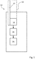
- Fig. 1 shows a navigation device 10.
- the navigation device 10 may be a standalone/handheld device.
- the navigation device 10 may be included in a compound device, e.g. a cellphone/mobile phone/smartphone, and/or in a vehicle, e.g. a car, ship, air plane, etc.
- the navigation device may include a display for displaying navigation and/or map-data.
- the navigation device may include a pathfinding circuit configured to calculate a path between two given points according to map data.
- the navigation device may include a data link to transmit user positions to other users, remote servers, remote applications.
- Fig. 2 shows earth 40, the navigation device 10 of Figure 1 and a first navigation satellite 20.
- the first navigation satellite 20 may orbit earth 40 in a geostationary orbit 24.
- the geostationary orbit 24 may at least essentially be within an equatorial plane 44 of earth.
- the navigation device 10 may be positioned somewhere on earth 40 within reach of a first signal 22 from the first navigation satellite 20.
- Fig. 2 further shows a first coordinate system 30 and a second coordinate system 32.
- the first coordinate system 30 may have two axis that are parallel to (or within) the equatorial plane 44.
- the second coordinate system 32 may be tilted in regard to the first coordinate system 30 by an angle ⁇ .
- Two axis of the second corrdinate system 32 may span a plane that is tilted by the angle ⁇ in regard to the equatorial plane 44.
- the navigation device 10 includes a receiving circuit 12.
- the receiving circuit 12 is configured to receive at least a first signal 22 from at least the first navigation satellite 20 (see Fig. 2 ).
- the first signal 22 provides at least a first timestamp t K .
- the first navigation satellite 20 may be a geostationary satellite.
- the first navigation satellite 20 may be a BeiDou navigation satellite.
- the receiving circuit 12 may be configured to receive (timestamped) signals from further satellites.
- the further satellites may be geostationary, geosynchronous and/or medium earth orbit satellites.
- the receiving circuit 12 may include at least one antenna 13 (or an antenna matrix) and an evaluation circuit 14.
- the evaluation circuit 14 may be configured to evaluate (analyze) signals received via the at least one antenna 13.
- the evaluation circuit 14 may be configured to measure the arrival time of timing signals broadcast by the navigation satellite (Code Phase) and the rate at which these signals arrive (Doppler), and also the phase of the carrier signal.
- the receiving circuit 12 may further be configured to receive the ephemeris data from the first navigation satellite 20.
- the evaluation circuit may be configured to decode low rate data (e.g. 50 bits per second), which is modulated on top of the timing signal. This low rate data may contain information about the navigation satellite constellation such as the ephemeris data.
- the ephemeris data may be received via a separate receiving circuit and/or from a different source that the first satellite (e.g. via Internet, WiFi).
- the ephemeris data may be Keplerian form ephemeris data.
- Ephemeris data of a navigation satellite may be a set of data that define an orbit of the navigation satellite in relation to a given coordinate system (the second coordinate system) and a position of the navigation satellite at a reference time.
- Ephemeris data may include at least the reference time and further may include a square root of semi-major axis of orbit, an eccentricity of orbit, an argument of perigee of orbit, a mean motion difference (from computed value), a mean anomaly at reference time, a longitude of ascending node of orbital plane 24 (computed according to reference time), a rate of right ascension, an inclination angle (at the reference time), a rate (of change) of the inclination angle, Correction parameters and/or further.
- the ephemeris data of the first (and further) navigation satellite may be updated regularly, e.g. every two hours, to atone for changes of orbit, e.g. due to drifting of the navigation satellite towards a more stable/preferred orbit that differs from the intended orbit, or e.g. due to correction maneuvers of the navigation satellite that (appear from time to time) and/or other influences.
- the navigation device 10 further includes a determination circuit 16.
- the evaluation circuit 14 may be configured to provide received data to the determination circuit 16.
- the determination circuit 16 is configured to determine at least a velocity (velocity vector) ⁇ K of the first navigation satellite in a first coordinate system 30 based on at least ephemeris data of the first navigation satellite 20 and the first timestamp t K .
- the determination circuit 16 may be configured to determine at least a velocity of at least a part of the further navigation satellites, from which a timestamped signal was received, in the first coordinate system 30 based on at least ephemeris data of the respective navigation satellite and the respective timestamp.
- the ephemeris data of at least the first navigation satellite (and the further satellites) is provided in relation to a second coordinate 32 system.
- the first coordinate system 30 is earth fixed.
- the first coordinate system 30 may be an orthogonal coordinate system. Alternatively the first coordinate system may be a polar coordinate system.
- the first coordinate system 30 may rotate together with earth 40.
- the first coordinate system 30 may rotate around the rotation axis 42 of earth 40 with the rotational speed of earth 40.
- a point of origin of the first coordinate system 30 may be fixed to a point (e.g. center) of earth 40.
- the first coordinate system 30 may be a China Geodetic Coordinate System (e.g. CGCS2000 or a future variation).
- the second coordinate system 32 is at least tilted in relation (in regard) to the equatorial plane 44.
- the second coordinate system 32 may be tilted in relation to the equatorial plane 44 by at least 3 degrees, e.g. at least 4 degrees, e.g. at least 5 degrees. All axis of the second coordinate system 32 may enclose angles of at least 3 degrees, e.g. at least 4 degrees, e.g. at least 5 degrees, with the rotational axis 42 of the first coordinate system 30 (rotational axis of earth).
- the second coordinate system may include one axis 34 that has an angle ⁇ (e.g. a constant angle), e.g. between 1 and 179 degrees, e.g.
- the second coordinate system 32 may be an orthogonal coordinate system.
- the second coordinate system 32 may be at least essentially non-rotating in relation to the fixed stars.
- a point of origin of the second coordinate system 32 may be fixed to a point (e.g. center) of earth 40.
- the first and second coordinate systems 30, 32 may have the same point of origin.
- the navigation device 10 further includes a navigation circuit 18 configured to determine navigation information (e.g. position, velocity, acceleration, direction of movement, orientation, and others) of the receiving circuit 12 within (in relation to) the first coordinate system based on at least the determined velocity of at least the first navigation satellite 20 (and the further satellites, e.g. at least 3 navigation satellites in total).
- Navigation information of the receiving circuit 12 may be understood as navigation information of the antenna 13 of the receiving circuit 12 and/or navigation information of a user handling the navigation device.
- the navigation circuit 18 may be configured to determine the navigation information based on position, velocity and/or acceleration of the first and further navigation satellites in the first coordinate system.
- the determination circuit 16 may be provided to provide determined data, e.g. position, velocity and/or acceleration of the first satellite in the first coordinate system to the navigation circuit.
- the navigation circuit 18, the determination circuit 16 and/or the evaluation circuit 14 may each be represented by an application specific integrated circuits (ASICs), as variable processing units (e.g. CPUs), or as multiple software entities on a same CPU. Two or more of the navigation circuit 18, the determination circuit 16 and/or the evaluation circuit 14 may be included into a single processing unit and/or software (in combination with a program/application). The determination circuit and the navigation circuit may be combined as a positioning engines (PE).
- ASICs application specific integrated circuits
- CPUs variable processing units
- PE positioning engines
- ⁇ K is the longitude of the corrected longitude of the ascending node at timestamp t K
- (x K , y K , 0) T is the position of the navigation satellite 20 within its orbital plane 24 at timestamp t K
- i K is the inclination at timestamp t K
- ⁇ K , x K , y K and i K are determined via the ephemeris data.
- the determination circuit 16 may be configured to determine the position P K of the first navigation satellite in the first coordinate system 20 at the first timestamp t K using the transformation matrix T(t K ) from the second to the first coordinate system:
- ⁇ may be the tilt angle between the earths rotational axis and the Z-axis of the second coordinate system, e.g. 5 degrees.
- ⁇ e is the rotation rate of the first coordinate system 30 in relation to the second coordinate system 32.
- ⁇ e may be the earth rotation rate (of CGCS2000).
- the determination circuit 16 may be configured to determine at least a velocity ⁇ GK of the first navigation satellite 20 in the second coordinate system 32 from the ephemeris data:
- ⁇ K ⁇ is the rate (of change) of the (right) ascension node and i _ dot is the rate (of change) of the inclination. Both values may be provided as ephemeris data or be calculated therefrom.
- ( ⁇ K ⁇ K 0) T is the velocity (vector) of the first navigation satellite in the orbital plane 24, as can be determined from the ephemeris data.
- the determination circuit 16 may be configured to determine at least a time derivative of a transformation matrix between the second coordinate system 32 and the first coordinate system 30 for determining the velocity ⁇ K of the first navigation satellite in the first coordinate system 30.
- the determination circuit may be configured to determine the velocity of the first navigation satellite by using the transformation matrix T(t K ) to transform the velocity from the second to the first coordinate system and adding a correction by applying the time derivative of the transformation matrix T(t K ) to the position of the first navigation satellite 20 in the second coordinate system:
- the receiving circuit 12 may be configured to measure (or determine) a Doppler shift (e.g. a difference of the received carrier frequency to the nominal carrier frequency that is used by the satellite to send the signal) of at least the first signal 22.
- the navigation circuit 18 may be configured to determine at least a velocity of the receiving circuit within the first coordinate system, based on the Doppler shift of the first signal 22 (and the Doppler shift of signals of further navigation satellites) and the determined velocity of at least the first navigation satellite (and the further satellites for which a signal was received at the timestamp) in the first coordinate system.
- the navigation circuit may be configured to determine a relative velocity between the first navigation satellite and the receiving circuit from the Doppler shift.
- the navigation circuit may be configured to determine a differential velocity based on the determined relative velocity and the determined velocity of the first navigation satellite in the first coordinate system.
- the navigation circuit 18 may be configured to determine (estimate) a velocity of the receiving circuit based by finding (optimization problem) an user velocity for which an expected Doppler shift calculated/determined/computed based on the navigation satellite's velocity in the first coordinate system, the (estimated) user velocity (and a clock drift) fits the measured Doppler shift.
- the determination circuit is configured to determine at least an acceleration P ⁇ GK of the first navigation satellite in the second coordinate system 32 from the ephemeris data of the first navigation satellite and the first timestamp t K :
- P ⁇ GK X ⁇ GK Y ⁇ GK Z ⁇ GK ⁇ ⁇ K 2 ⁇ cos ⁇ K sin ⁇ K cos i K ⁇ sin ⁇ K sin i K ⁇ sin ⁇ K ⁇ sin ⁇ K cos i K cos ⁇ K sin i K 0 0 0 0 x K y K 0 + i_ dot 2 0 sin ⁇ K sin i K ⁇ sin ⁇ K cos i K 0 ⁇ cos ⁇ K sin i K cos ⁇ K cos i K 0 ⁇ sin i K ⁇ cos i K + 2 ⁇ ⁇ ⁇ K ⁇ i_dot 0 cos ⁇ K sin i K ⁇ cos ⁇ K cos i
- ⁇ K ⁇ K 0 T is the acceleration (vector) of the first navigation satellite in the orbital plane 24, as can be determined from the ephemeris data.
- the determination circuit 16 may be configured to determine at least an acceleration P ⁇ K of the first navigation satellite in the first coordinate system 30. It may be determined by transforming the acceleration P ⁇ GK of the first navigation satellite in the second coordinate system 32 and correcting by terms comprising a first order time derivative of the transformation matrix T(t K ) and by terms comprising a second order time derivation of the transformation matrix T(t K ):
- the determination circuit 16 may be configured to determine at least a position of the first navigation satellite for the first timestamp from the ephemeris data.
- the determination circuit 16 may be configured to determine at least a position of the further navigation satellites for the first timestamp from the respective ephemeris data.
- the determination circuit 16 may be configured to determine at least the position and/or the velocity of the first navigation satellite in the first coordinate system for at least one further timestamp based on at least the position, velocity and acceleration (and/or further derivatives as jerk and snap) determined for the first timestamp and a time difference between the first and further timestamp, e.g. when the difference between the first and further timestamp is less than 10 minutes, e.g. less than 5 minutes, e.g.
- the further timestamp may be transmitted via a further signal from the first navigation satellite 20.
- the further timestamp may be later than the first timestamp.
- the determination circuit may be configured to calculate position and/or velocity of the first navigation satellite for the further timestamp in the first coordinate system from the ephemeris data when the first timestamp is more than 15 seconds, e.g. more than 30 seconds, e.g. more than 1 minute, e.g. more than5 minutes, e.g. more than10 minutes, older than the further timestamp. This may allow a high efficiency and/or reduce power consumption and/or time consumption, e.g. since less complex calculations are needed.
- the determination circuit 16 may be configured to determine position, velocity and acceleration data of at least the first navigation satellite in the first coordinate system at least for a first reference time, e.g. in a periodical fashion, e.g. every 30 seconds, from the ephemeris data, e.g. independent of a received timestamp.
- the determination circuit 16 may be configured to determine at least the position and/or the velocity of the first navigation satellite in the first coordinate system for at least the first timestamp based on the position, velocity and acceleration determined for the first reference time and a time difference between the first reference time and the first timestamp, e.g. when the difference is less than 10 minutes, e.g. less than 5 minutes, e.g. less than 1 minute, e.g. less than 30 seconds, e.g. less than 15 seconds, e.g. by polynomial motion formulas.
- Fig. 3 shows a system 50a for determining navigation information of a navigation device 10a.
- the system 50a includes a determination device 11a and the navigation device 10a.
- the determination device 11 a includes a determination circuit 16a.
- the determination circuit 16a is configured to determine a velocity of a first navigation satellite 20a for a first timestamp in a second coordinate system based on ephemeris data of the first navigation satellite 20a (for detailed description of the functionality of the determination circuit please refer to the descpricon of Fig. 1 and 2 ).
- the second coordinate system is tilted in relation to the equatorial plane.
- the determination circuit 16a is further configured to determine a velocity of the first navigation satellite in a first coordinate system that is earth fixed and rotating with earth.
- the determination circuit 16 may be configured to determine the velocity of the first navigation satellite 20a in the first coordinate system by applying a transformation matrix to the determined velocity of the first navigation satellite 20a in the second coordinate system and adding a correction term based on a time derivative of the transformation matrix.
- the determination device 11 a further comprises a communication circuit 15a for sending the determined velocity of the first navigation satellite 20a in the first coordinate system to the navigation device 10a.
- the navigation device 10a comprises a receiving circuit 12a configured to receive a first signal 22a from the first navigation satellite, the first signal comprising the first timestamp.
- the receiving circuit 12a is further configured to receive the determined velocity of the first navigation satellite 20a in the first coordinate system from the determination device 11 a.
- the receiveing circuit 12a may include an antenna 13a and an evaluation circuit 14a.
- the navigation device further comprises a navigation circuit 18a configured to determine the navigation information of the receiving circuit 12a within the first coordinate system based on at least the determined velocity of at least the first navigation satellite 20a.
- the determination device 11 a may be configured to be included into the first navigation satellite 20a.
- the system 50a may further include the first navigation satellite 20a.
- the determination device 11a may be included into the first navigation satellite 20a.
- the determined velocity (of at least the first navigation satellite 20a in the first coordinate system) may be included in the first signal 22a.
- the navigation device 10a may include a communication circuit for sending the timestamp received from the first navigation satellite to the determination circuit 11 a.
- the determination device may be configured to receive (e.g. via the communication circuit) the ephemeris data of the first navigation satellite from the navigation device, from the first navigation satellite and/or from a central distribution system (server, e.g. via a communication network connection/internet connection). More than one way of receiving the ephemeis data may be used at the same time to ensure best possible coverage, accuracy, flexibility, and/or response time.
- Example 1 is a navigation device comprising: a receiving circuit configured to receive a first signal from a first navigation satellite, the first signal comprising a first timestamp; a determination circuit configured to determine a velocity of the first navigation satellite at the first timestamp in a second coordinate system based on ephemeris data of the first navigation satellite, the second coordinate system being tilted in relation to the equatorial plane; the determination circuit further configured to determine a velocity of the first navigation satellite in a first coordinate system that is earth fixed and rotating with earth based on the determined velocity in the second coordinate system; a navigation circuit configured to determine navigation information of the receiving circuit within the first coordinate system based on at least the determined velocity of at least the first navigation satellite.
- example 2 the subject matter of example 1 can optionally include that the determination circuit is configured to determine the velocity of the first navigation satellite in the first coordinate system by applying a transformation matrix to the determined velocity of the first navigation satellite in the second coordinate system and adding a correction term based on a time derivative of the transformation matrix.
- any of examples 1-2 can optionally include that the navigation circuit is configured to determine at least a velocity of the receiving circuit within the first coordinate system, based on a Doppler shift of the first signal and the determined velocity of at least the first navigation satellite.
- any of examples 1-3 can optionally include that the receiving circuit is configured to receive the ephemeris data from the first navigation satellite.
- any of examples 1-4 can optionally include that the second coordinate system is tilted in relation to the equatorial plane by at least 3 degrees.
- any of examples 1-5 can optionally include that the first navigation satellite is a geostationary satellite.
- any of examples 1-6 can optionally include that the first navigation satellite is a BeiDou navigation satellite.
- any of examples 1-7 can optionally include that the first coordinate system is a China Geodetic Coordinate System.
- any of examples 1-8 can optionally include that the determination circuit is configured to determine at least an acceleration of the first navigation satellite in the first coordinate system from the ephemeris data of the first navigation satellite and the first timestamp.
- example 10 the subject matter of example 9 can optionally include that the determination circuit is configured to determine at least an acceleration of the first navigation satellite in the second coordinate system from the ephemeris data for determining the acceleration of the first navigation satellite in the first coordinate system.
- the subject matter of any of examples 9-10 can optionally include that the determination circuit is configured to determine at least a second order time derivative of a transformation matrix between the first coordinate system and the second coordinate system for determining the acceleration of the first navigation satellite in the first coordinate system.
- any of examples 9-11 can optionally include that the determination circuit is configured to determine a position of the first navigation satellite for the first timestamp from the ephemeris data and is configured to determine at least the position of the first navigation satellite in the first coordinate system for at least one further timestamp based on at least the position, velocity and acceleration determined for the first timestamp and a time difference between the first and further timestamp.
- Example 13 is a method for determining navigation information, the method comprising: receiving at least a first signal from at least a first navigation satellite, the signal comprising a first timestamp; determining a velocity of the first navigation satellite at the first timestamp in a second coordinate system based on ephemeris data of the first navigation satellite, the second coordinate system being tilted in relation to the equatorial plane; determining a velocity of the first navigation satellite in a first coordinate system that is earth fixed and rotating with earth based on the determined velocity in the second coordinate system; determining navigation information of the receiving circuit within the first coordinate system based on at least the determined velocity of at least the first navigation satellite.
- example 14 the subject matter of example 13 can optionally include that determining the velocity of the first navigation satellite in the first coordinate system includes applying a transformation matrix to the determined velocity of the first navigation satellite in the second coordinate system and adding a correction term based on a time derivative of the transformation matrix.
- determining navigation information includes determining at least a velocity of the receiving circuit within the first coordinate system, based on a Doppler shift of the first signal and the velocity of at least the first navigation satellite.
- any of examples 13-15 can optionally include: receiving the ephemeris data from the first navigation satellite.
- any of examples 13-16 can optionally include that the second coordinate system is tilted in relation to the equatorial plane by at least 3 degrees.
- any of examples 13-17 can optionally include that the first navigation satellite is a geostationary satellite.
- any of examples 13-18 can optionally include that the first navigation satellite is a BeiDou navigation satellite.
- any of examples 13-19 can optionally include that the first coordinate system is a China Geodetic Coordinate System.
- any of examples 13-20 can optionally include: determine at least an acceleration of the first navigation satellite in the first coordinate system from the ephemeris data of the first navigation satellite and the first timestamp.
- example 22 the subject matter of example 21 can optionally include that determining the acceleration of the first navigation satellite in the first coordinate system comprises determining at least an acceleration of the first navigation satellite in the second coordinate system from the ephemeris data for.
- determining the acceleration of the first navigation satellite in the first coordinate system comprises determining at least a second order time derivative of a transformation matrix between the first coordinate system and the second coordinate system for.
- any of examples 21-23 can optionally include: determining a position of the first navigation satellite for the first timestamp from the ephemeris data and determining at least the position of the first navigation satellite in the first coordinate system for at least one further timestamp based on at least the position, velocity and acceleration determined for the first timestamp and a time difference between the first and further timestamp.
- Example 25 is a determination device in a system for determining navigation information of a navigation device, the determination device comprising: a determination circuit and a communication circuit, the determination circuit configured to determine a velocity of a first navigation satellite for a first timestamp in a second coordinate system based on ephemeris data of the first navigation satellite, the second coordinate system being tilted in relation to the equatorial plane; the determination circuit further configured to determine a velocity of the first navigation satellite in a first coordinate system that is earth fixed and rotating with earth based on the determined velocity in the second coordinate system; the communication circuit configured to send the determined velocity to the navigation device.
- example 26 the subject matter of example 25 can optionally include that the determination circuit is configured to determine the velocity of the first navigation satellite in the first coordinate system by applying a transformation matrix to the determined velocity of the first navigation satellite in the second coordinate system and adding a correction term based on a time derivative of the transformation matrix.
- any of examples 25-26 can optionally include that the communication circuit is configured to receive the timestamp from the navigation device and provide the timestamp to the determination circuit.
- any of examples 25-27 can optionally include that the determination device is configured to be included into the first navigation satellite.
- any of examples 25-28 can optionally include that the communication circuit is configured to send the first time stamp together with the determined velocity for the first time stamp to the navigation device.
- any of examples 25-29 can optionally include that the communication circuit is configured to receive the ephemeris data of the first navigation satellite and provide it to the determination circuit.
Landscapes
- Engineering & Computer Science (AREA)
- Radar, Positioning & Navigation (AREA)
- Remote Sensing (AREA)
- Computer Networks & Wireless Communication (AREA)
- Physics & Mathematics (AREA)
- General Physics & Mathematics (AREA)
- Signal Processing (AREA)
- Position Fixing By Use Of Radio Waves (AREA)
- Navigation (AREA)
Abstract
Description
- Embodiments described herein generally relate to navigation devices and methods for determining navigation information.
- Since the global positioning system (GPS) was introduced by the US military, new navigation satellite projects (e.g. by Russia (GLONASS), EU (Galileo)) have been lunched in order to give an alternative, improve or complement the existing GPS. Suppliers of navigation equipment see the value of trying to make use of all of the systems to get better navigation information and/or better coverage in built up areas where there are lots of blockages. One of these new navigation satellite projects is Chinas BeiDou Navigation Satellite System (BDS). BDS uses the same form of ephemeris as GPS for their IGSO (inclined geosynchronous orbit) and MEO (medium earth orbit) satellites. Unlike GPS, BDS also makes use of geostationary satellites and had to introduce a new form of ephemeris to support them. BDS introduces a new form for providing ephemeris data for geostationary satellites, wherein the ephemeris data is provided in relation to a reference plane that is tilted in reference to the equatorial plane. This is because for the geostationary orbits, which are over the equator, the orbit inclination would be near zero (or even zero) in classic GPS ephemeris form which can results in a singularity in the Keplerian orbit math. Determination of position and velocity of geostationary satellites is important for determining accurate navigation information (e.g. user position and/or user velocity), since an orbit of a geostationary satellite is influenced by a couple of factors. E.g. most geostationary orbits are instable (unstable) due to inhomogeneities in the earths form and due to influences of sun and moon, which causes a longitudinal drift of the satellite (especially if the orbit is not exactly geostationary) and therefore may need correction (from time to time). Further it is challenging to position a satellite in an exact geostationary orbit, which causes the satellite to move (wobble) in a small ellipse or figure 8 (in relation to a fixed point on earth). Therefore position and velocity of satellites positioned in geostationary orbits vary (slightly) which needs to be considered when calculating navigation information.
-
- Fig. 1
- shows a schematic view of a navigation device,
- Fig. 2
- shows a schematic view of a navigation satellite in an orbit and a navigation device on earth and
- Fig. 3
- shows a schematic view of a system for determining navigation information.
-
Fig. 1 shows anavigation device 10. Thenavigation device 10 may be a standalone/handheld device. Thenavigation device 10 may be included in a compound device, e.g. a cellphone/mobile phone/smartphone, and/or in a vehicle, e.g. a car, ship, air plane, etc. The navigation device may include a display for displaying navigation and/or map-data. The navigation device may include a pathfinding circuit configured to calculate a path between two given points according to map data. The navigation device may include a data link to transmit user positions to other users, remote servers, remote applications. -
Fig. 2 showsearth 40, thenavigation device 10 ofFigure 1 and afirst navigation satellite 20. Thefirst navigation satellite 20 may orbitearth 40 in ageostationary orbit 24. Thegeostationary orbit 24 may at least essentially be within anequatorial plane 44 of earth. Thenavigation device 10 may be positioned somewhere onearth 40 within reach of afirst signal 22 from thefirst navigation satellite 20.Fig. 2 further shows afirst coordinate system 30 and asecond coordinate system 32. Thefirst coordinate system 30 may have two axis that are parallel to (or within) theequatorial plane 44. Thesecond coordinate system 32 may be tilted in regard to thefirst coordinate system 30 by an angle α. Two axis of thesecond corrdinate system 32 may span a plane that is tilted by the angle α in regard to theequatorial plane 44. - The
navigation device 10 includes areceiving circuit 12. Thereceiving circuit 12 is configured to receive at least afirst signal 22 from at least the first navigation satellite 20 (seeFig. 2 ). Thefirst signal 22 provides at least a first timestamp tK. Thefirst navigation satellite 20 may be a geostationary satellite. Thefirst navigation satellite 20 may be a BeiDou navigation satellite. Thereceiving circuit 12 may be configured to receive (timestamped) signals from further satellites. The further satellites may be geostationary, geosynchronous and/or medium earth orbit satellites. - The
receiving circuit 12 may include at least one antenna 13 (or an antenna matrix) and anevaluation circuit 14. Theevaluation circuit 14 may be configured to evaluate (analyze) signals received via the at least oneantenna 13. Theevaluation circuit 14 may be configured to measure the arrival time of timing signals broadcast by the navigation satellite (Code Phase) and the rate at which these signals arrive (Doppler), and also the phase of the carrier signal. Thereceiving circuit 12 may further be configured to receive the ephemeris data from thefirst navigation satellite 20. The evaluation circuit may be configured to decode low rate data (e.g. 50 bits per second), which is modulated on top of the timing signal. This low rate data may contain information about the navigation satellite constellation such as the ephemeris data. According to further embodiments the ephemeris data may be received via a separate receiving circuit and/or from a different source that the first satellite (e.g. via Internet, WiFi). The ephemeris data may be Keplerian form ephemeris data. Ephemeris data of a navigation satellite may be a set of data that define an orbit of the navigation satellite in relation to a given coordinate system (the second coordinate system) and a position of the navigation satellite at a reference time. Ephemeris data may include at least the reference time and further may include a square root of semi-major axis of orbit, an eccentricity of orbit, an argument of perigee of orbit, a mean motion difference (from computed value), a mean anomaly at reference time, a longitude of ascending node of orbital plane 24 (computed according to reference time), a rate of right ascension, an inclination angle (at the reference time), a rate (of change) of the inclination angle, Correction parameters and/or further. The ephemeris data of the first (and further) navigation satellite may be updated regularly, e.g. every two hours, to atone for changes of orbit, e.g. due to drifting of the navigation satellite towards a more stable/preferred orbit that differs from the intended orbit, or e.g. due to correction maneuvers of the navigation satellite that (appear from time to time) and/or other influences. - The
navigation device 10 further includes adetermination circuit 16. The evaluation circuit 14 (measuring engine, ME) may be configured to provide received data to thedetermination circuit 16. - The
determination circuit 16 is configured to determine at least a velocity (velocity vector) ṖK of the first navigation satellite in afirst coordinate system 30 based on at least ephemeris data of thefirst navigation satellite 20 and the first timestamp tK. Thedetermination circuit 16 may be configured to determine at least a velocity of at least a part of the further navigation satellites, from which a timestamped signal was received, in thefirst coordinate system 30 based on at least ephemeris data of the respective navigation satellite and the respective timestamp. The ephemeris data of at least the first navigation satellite (and the further satellites) is provided in relation to asecond coordinate 32 system. - The
first coordinate system 30 is earth fixed. Thefirst coordinate system 30 may be an orthogonal coordinate system. Alternatively the first coordinate system may be a polar coordinate system. Thefirst coordinate system 30 may rotate together withearth 40. Thefirst coordinate system 30 may rotate around therotation axis 42 ofearth 40 with the rotational speed ofearth 40. A point of origin of the first coordinatesystem 30 may be fixed to a point (e.g. center) ofearth 40. The first coordinatesystem 30 may be a China Geodetic Coordinate System (e.g. CGCS2000 or a future variation). - The second coordinate
system 32 is at least tilted in relation (in regard) to theequatorial plane 44. The second coordinatesystem 32 may be tilted in relation to theequatorial plane 44 by at least 3 degrees, e.g. at least 4 degrees, e.g. at least 5 degrees. All axis of the second coordinatesystem 32 may enclose angles of at least 3 degrees, e.g. at least 4 degrees, e.g. at least 5 degrees, with therotational axis 42 of the first coordinate system 30 (rotational axis of earth). The second coordinate system may include oneaxis 34 that has an angle α (e.g. a constant angle), e.g. between 1 and 179 degrees, e.g. between 1 and 90 degrees, e.g. between 1 and 40 degrees, e.g. between 2 and 20 degrees, e.g. between 3 and 10 degrees, e.g. between 4 and 7 degrees, e.g. of 5 degrees with therotational axis 42 of the first coordinate system 30 (rotational axis of earth). The second coordinatesystem 32 may be an orthogonal coordinate system. The second coordinatesystem 32 may be at least essentially non-rotating in relation to the fixed stars. A point of origin of the second coordinatesystem 32 may be fixed to a point (e.g. center) ofearth 40. The first and second coordinatesystems - The
navigation device 10 further includes anavigation circuit 18 configured to determine navigation information (e.g. position, velocity, acceleration, direction of movement, orientation, and others) of the receivingcircuit 12 within (in relation to) the first coordinate system based on at least the determined velocity of at least the first navigation satellite 20 (and the further satellites, e.g. at least 3 navigation satellites in total). Navigation information of the receivingcircuit 12 may be understood as navigation information of theantenna 13 of the receivingcircuit 12 and/or navigation information of a user handling the navigation device. Thenavigation circuit 18 may be configured to determine the navigation information based on position, velocity and/or acceleration of the first and further navigation satellites in the first coordinate system. - The
determination circuit 16 may be provided to provide determined data, e.g. position, velocity and/or acceleration of the first satellite in the first coordinate system to the navigation circuit. - The
navigation circuit 18, thedetermination circuit 16 and/or theevaluation circuit 14 may each be represented by an application specific integrated circuits (ASICs), as variable processing units (e.g. CPUs), or as multiple software entities on a same CPU. Two or more of thenavigation circuit 18, thedetermination circuit 16 and/or theevaluation circuit 14 may be included into a single processing unit and/or software (in combination with a program/application). The determination circuit and the navigation circuit may be combined as a positioning engines (PE). - The
determination circuit 16 may be configured to determine a position PGK of the first navigation satellite in the second coordinate 32 system at the first timestamp tK according to the following:
- Herein ΩK is the longitude of the corrected longitude of the ascending node at timestamp tK, (xK, yK, 0)T is the position of the
navigation satellite 20 within itsorbital plane 24 at timestamp tK, iK is the inclination at timestamp tK. Herein ΩK, xK, yK and iK are determined via the ephemeris data. - The
determination circuit 16 may be configured to determine the position PK of the first navigation satellite in the first coordinatesystem 20 at the first timestamp tK using the transformation matrix T(tK) from the second to the first coordinate system:
system 30 in relation to the second coordinatesystem 32. Ω̇ e may be the earth rotation rate (of CGCS2000). - The
determination circuit 16 may be configured to determine at least a velocity ṖGK of thefirst navigation satellite 20 in the second coordinatesystem 32 from the ephemeris data:
- Herein Ω̇K =Ω̇ is the rate (of change) of the (right) ascension node and i_dot is the rate (of change) of the inclination. Both values may be provided as ephemeris data or be calculated therefrom. (ẋK ẏK 0) T is the velocity (vector) of the first navigation satellite in the
orbital plane 24, as can be determined from the ephemeris data. - The
determination circuit 16 may be configured to determine at least a time derivative of a transformation matrix between the second coordinatesystem 32 and the first coordinatesystem 30 for determining the velocity ṖK of the first navigation satellite in the first coordinatesystem 30. The determination circuit may be configured to determine the velocity of the first navigation satellite by using the transformation matrix T(tK) to transform the velocity from the second to the first coordinate system and adding a correction by applying the time derivative of the transformation matrix T(tK) to the position of thefirst navigation satellite 20 in the second coordinate system:
- The receiving circuit 12 (e.g. the evaluation circuit 14) may be configured to measure (or determine) a Doppler shift (e.g. a difference of the received carrier frequency to the nominal carrier frequency that is used by the satellite to send the signal) of at least the
first signal 22. Thenavigation circuit 18 may be configured to determine at least a velocity of the receiving circuit within the first coordinate system, based on the Doppler shift of the first signal 22 (and the Doppler shift of signals of further navigation satellites) and the determined velocity of at least the first navigation satellite (and the further satellites for which a signal was received at the timestamp) in the first coordinate system. The navigation circuit may be configured to determine a relative velocity between the first navigation satellite and the receiving circuit from the Doppler shift. The navigation circuit may be configured to determine a differential velocity based on the determined relative velocity and the determined velocity of the first navigation satellite in the first coordinate system. Thenavigation circuit 18 may be configured to determine (estimate) a velocity of the receiving circuit based by finding (optimization problem) an user velocity for which an expected Doppler shift calculated/determined/computed based on the navigation satellite's velocity in the first coordinate system, the (estimated) user velocity (and a clock drift) fits the measured Doppler shift. - The determination circuit is configured to determine at least an acceleration P̈GK of the first navigation satellite in the second coordinate system 32 from the ephemeris data of the first navigation satellite and the first timestamp tK:

- Herein (ẍK ÿK 0) T is the acceleration (vector) of the first navigation satellite in the
orbital plane 24, as can be determined from the ephemeris data. - The
determination circuit 16 may be configured to determine at least an acceleration P̈K of the first navigation satellite in the first coordinatesystem 30. It may be determined by transforming the acceleration P̈GK of the first navigation satellite in the second coordinate system 32 and correcting by terms comprising a first order time derivative of the transformation matrix T(tK) and by terms comprising a second order time derivation of the transformation matrix T(tK):
- The
determination circuit 16 may be configured to determine at least a position of the first navigation satellite for the first timestamp from the ephemeris data. Thedetermination circuit 16 may be configured to determine at least a position of the further navigation satellites for the first timestamp from the respective ephemeris data. Thedetermination circuit 16 may be configured to determine at least the position and/or the velocity of the first navigation satellite in the first coordinate system for at least one further timestamp based on at least the position, velocity and acceleration (and/or further derivatives as jerk and snap) determined for the first timestamp and a time difference between the first and further timestamp, e.g. when the difference between the first and further timestamp is less than 10 minutes, e.g. less than 5 minutes, e.g. less than 1 minute, e.g. less than 30 seconds, e.g. less than 15 seconds, e.g. by polynomial motion formulas. The further timestamp may be transmitted via a further signal from thefirst navigation satellite 20. The further timestamp may be later than the first timestamp. The determination circuit may be configured to calculate position and/or velocity of the first navigation satellite for the further timestamp in the first coordinate system from the ephemeris data when the first timestamp is more than 15 seconds, e.g. more than 30 seconds, e.g. more than 1 minute, e.g. more than5 minutes, e.g. more than10 minutes, older than the further timestamp. This may allow a high efficiency and/or reduce power consumption and/or time consumption, e.g. since less complex calculations are needed. - According to further embodiments the
determination circuit 16 may be configured to determine position, velocity and acceleration data of at least the first navigation satellite in the first coordinate system at least for a first reference time, e.g. in a periodical fashion, e.g. every 30 seconds, from the ephemeris data, e.g. independent of a received timestamp. Thedetermination circuit 16 may be configured to determine at least the position and/or the velocity of the first navigation satellite in the first coordinate system for at least the first timestamp based on the position, velocity and acceleration determined for the first reference time and a time difference between the first reference time and the first timestamp, e.g. when the difference is less than 10 minutes, e.g. less than 5 minutes, e.g. less than 1 minute, e.g. less than 30 seconds, e.g. less than 15 seconds, e.g. by polynomial motion formulas. -
Fig. 3 shows asystem 50a for determining navigation information of anavigation device 10a. Thesystem 50a includes adetermination device 11a and thenavigation device 10a. Thedetermination device 11 a includes adetermination circuit 16a. Thedetermination circuit 16a is configured to determine a velocity of afirst navigation satellite 20a for a first timestamp in a second coordinate system based on ephemeris data of thefirst navigation satellite 20a (for detailed description of the functionality of the determination circuit please refer to the descpricon ofFig. 1 and2 ). The second coordinate system is tilted in relation to the equatorial plane. Thedetermination circuit 16a is further configured to determine a velocity of the first navigation satellite in a first coordinate system that is earth fixed and rotating with earth. Thedetermination circuit 16 may be configured to determine the velocity of thefirst navigation satellite 20a in the first coordinate system by applying a transformation matrix to the determined velocity of thefirst navigation satellite 20a in the second coordinate system and adding a correction term based on a time derivative of the transformation matrix. Thedetermination device 11 a further comprises acommunication circuit 15a for sending the determined velocity of thefirst navigation satellite 20a in the first coordinate system to thenavigation device 10a. Thenavigation device 10a comprises a receivingcircuit 12a configured to receive afirst signal 22a from the first navigation satellite, the first signal comprising the first timestamp. The receivingcircuit 12a is further configured to receive the determined velocity of thefirst navigation satellite 20a in the first coordinate system from thedetermination device 11 a. Thereceiveing circuit 12a may include anantenna 13a and anevaluation circuit 14a. The navigation device further comprises anavigation circuit 18a configured to determine the navigation information of the receivingcircuit 12a within the first coordinate system based on at least the determined velocity of at least thefirst navigation satellite 20a. - The
determination device 11 a may be configured to be included into thefirst navigation satellite 20a. Thesystem 50a may further include thefirst navigation satellite 20a. Thedetermination device 11a may be included into thefirst navigation satellite 20a. The determined velocity (of at least thefirst navigation satellite 20a in the first coordinate system) may be included in thefirst signal 22a. - According to further embodiments, the
navigation device 10a may include a communication circuit for sending the timestamp received from the first navigation satellite to thedetermination circuit 11 a. - According to various embodiments, the determination device may be configured to receive (e.g. via the communication circuit) the ephemeris data of the first navigation satellite from the navigation device, from the first navigation satellite and/or from a central distribution system (server, e.g. via a communication network connection/internet connection). More than one way of receiving the ephemeis data may be used at the same time to ensure best possible coverage, accuracy, flexibility, and/or response time.
- The following examples pertain to further embodiments.
- Example 1 is a navigation device comprising: a receiving circuit configured to receive a first signal from a first navigation satellite, the first signal comprising a first timestamp; a determination circuit configured to determine a velocity of the first navigation satellite at the first timestamp in a second coordinate system based on ephemeris data of the first navigation satellite, the second coordinate system being tilted in relation to the equatorial plane; the determination circuit further configured to determine a velocity of the first navigation satellite in a first coordinate system that is earth fixed and rotating with earth based on the determined velocity in the second coordinate system; a navigation circuit configured to determine navigation information of the receiving circuit within the first coordinate system based on at least the determined velocity of at least the first navigation satellite.
- In example 2, the subject matter of example 1 can optionally include that the determination circuit is configured to determine the velocity of the first navigation satellite in the first coordinate system by applying a transformation matrix to the determined velocity of the first navigation satellite in the second coordinate system and adding a correction term based on a time derivative of the transformation matrix.
- In example 3, the subject matter of any of examples 1-2 can optionally include that the navigation circuit is configured to determine at least a velocity of the receiving circuit within the first coordinate system, based on a Doppler shift of the first signal and the determined velocity of at least the first navigation satellite.
- In example 4, the subject matter of any of examples 1-3 can optionally include that the receiving circuit is configured to receive the ephemeris data from the first navigation satellite.
- In example 5, the subject matter of any of examples 1-4 can optionally include that the second coordinate system is tilted in relation to the equatorial plane by at least 3 degrees.
- In example 6, the subject matter of any of examples 1-5 can optionally include that the first navigation satellite is a geostationary satellite.
- In example 7, the subject matter of any of examples 1-6 can optionally include that the first navigation satellite is a BeiDou navigation satellite.
- In example 8, the subject matter of any of examples 1-7 can optionally include that the first coordinate system is a China Geodetic Coordinate System.
- In example 9, the subject matter of any of examples 1-8 can optionally include that the determination circuit is configured to determine at least an acceleration of the first navigation satellite in the first coordinate system from the ephemeris data of the first navigation satellite and the first timestamp.
- In example 10, the subject matter of example 9 can optionally include that the determination circuit is configured to determine at least an acceleration of the first navigation satellite in the second coordinate system from the ephemeris data for determining the acceleration of the first navigation satellite in the first coordinate system.
- In example 11, the subject matter of any of examples 9-10 can optionally include that the determination circuit is configured to determine at least a second order time derivative of a transformation matrix between the first coordinate system and the second coordinate system for determining the acceleration of the first navigation satellite in the first coordinate system.
- In example 12, the subject matter of any of examples 9-11 can optionally include that the determination circuit is configured to determine a position of the first navigation satellite for the first timestamp from the ephemeris data and is configured to determine at least the position of the first navigation satellite in the first coordinate system for at least one further timestamp based on at least the position, velocity and acceleration determined for the first timestamp and a time difference between the first and further timestamp.
- Example 13 is a method for determining navigation information, the method comprising: receiving at least a first signal from at least a first navigation satellite, the signal comprising a first timestamp; determining a velocity of the first navigation satellite at the first timestamp in a second coordinate system based on ephemeris data of the first navigation satellite, the second coordinate system being tilted in relation to the equatorial plane; determining a velocity of the first navigation satellite in a first coordinate system that is earth fixed and rotating with earth based on the determined velocity in the second coordinate system; determining navigation information of the receiving circuit within the first coordinate system based on at least the determined velocity of at least the first navigation satellite.
- In example 14, the subject matter of example 13 can optionally include that determining the velocity of the first navigation satellite in the first coordinate system includes applying a transformation matrix to the determined velocity of the first navigation satellite in the second coordinate system and adding a correction term based on a time derivative of the transformation matrix.
- In example 15, the subject matter of any of examples 13-14 can optionally include that determining navigation information includes determining at least a velocity of the receiving circuit within the first coordinate system, based on a Doppler shift of the first signal and the velocity of at least the first navigation satellite.
- In example 16, the subject matter of any of examples 13-15 can optionally include: receiving the ephemeris data from the first navigation satellite.
- In example 17, the subject matter of any of examples 13-16 can optionally include that the second coordinate system is tilted in relation to the equatorial plane by at least 3 degrees.
- In example 18, the subject matter of any of examples 13-17 can optionally include that the first navigation satellite is a geostationary satellite.
- In example 19, the subject matter of any of examples 13-18 can optionally include that the first navigation satellite is a BeiDou navigation satellite.
- In example 20, the subject matter of any of examples 13-19 can optionally include that the first coordinate system is a China Geodetic Coordinate System.
- In example 21, the subject matter of any of examples 13-20 can optionally include: determine at least an acceleration of the first navigation satellite in the first coordinate system from the ephemeris data of the first navigation satellite and the first timestamp.
- In example 22, the subject matter of example 21 can optionally include that determining the acceleration of the first navigation satellite in the first coordinate system comprises determining at least an acceleration of the first navigation satellite in the second coordinate system from the ephemeris data for.
- In example 23, the subject matter of any of examples 21-22 can optionally include that determining the acceleration of the first navigation satellite in the first coordinate system comprises determining at least a second order time derivative of a transformation matrix between the first coordinate system and the second coordinate system for.
- In example 24, the subject matter of any of examples 21-23 can optionally include: determining a position of the first navigation satellite for the first timestamp from the ephemeris data and determining at least the position of the first navigation satellite in the first coordinate system for at least one further timestamp based on at least the position, velocity and acceleration determined for the first timestamp and a time difference between the first and further timestamp.
- Example 25 is a determination device in a system for determining navigation information of a navigation device, the determination device comprising: a determination circuit and a communication circuit, the determination circuit configured to determine a velocity of a first navigation satellite for a first timestamp in a second coordinate system based on ephemeris data of the first navigation satellite, the second coordinate system being tilted in relation to the equatorial plane; the determination circuit further configured to determine a velocity of the first navigation satellite in a first coordinate system that is earth fixed and rotating with earth based on the determined velocity in the second coordinate system; the communication circuit configured to send the determined velocity to the navigation device.
- In example 26, the subject matter of example 25 can optionally include that the determination circuit is configured to determine the velocity of the first navigation satellite in the first coordinate system by applying a transformation matrix to the determined velocity of the first navigation satellite in the second coordinate system and adding a correction term based on a time derivative of the transformation matrix.
- In example 27, the subject matter of any of examples 25-26 can optionally include that the communication circuit is configured to receive the timestamp from the navigation device and provide the timestamp to the determination circuit.
- In example 28, the subject matter of any of examples 25-27 can optionally include that the determination device is configured to be included into the first navigation satellite.
- In example 29, the subject matter of any of examples 25-28 can optionally include that the communication circuit is configured to send the first time stamp together with the determined velocity for the first time stamp to the navigation device.
- In example 30, the subject matter of any of examples 25-29 can optionally include that the communication circuit is configured to receive the ephemeris data of the first navigation satellite and provide it to the determination circuit.
Claims (15)
- A navigation device comprising:a receiving circuit configured to receive a first signal from a first navigation satellite, the first signal comprising a first timestamp;a determination circuit configured to determine a velocity of the first navigation satellite at the first timestamp in a second coordinate system based on ephemeris data of the first navigation satellite, the second coordinate system being tilted in relation to the equatorial plane;the determination circuit further configured to determine a velocity of the first navigation satellite in a first coordinate system that is earth fixed and rotating with earth based on the determined velocity in the second coordinate system;a navigation circuit configured to determine navigation information of the receiving circuit within the first coordinate system based on at least the determined velocity of at least the first navigation satellite.
- The navigation device of claim 1,
wherein the determination circuit is configured to determine the velocity of the first navigation satellite in the first coordinate system by applying a transformation matrix to the determined velocity of the first navigation satellite in the second coordinate system and adding a correction term based on a time derivative of the transformation matrix. - The navigation device of claim 1 or 2,
wherein the navigation circuit is configured to determine at least a velocity of the receiving circuit within the first coordinate system, based on a Doppler shift of the first signal and the determined velocity of at least the first navigation satellite. - The navigation device of any of claims 1-3,
wherein the receiving circuit is configured to receive the ephemeris data from the first navigation satellite. - The navigation device of any of claims 1-4,
wherein the second coordinate system is tilted in relation to the equatorial plane by at least 3 degrees. - The navigation device of any of claims 1-5,
wherein the first navigation satellite is a geostationary satellite. - The navigation device of any of claims 1-6,
wherein the first navigation satellite is a BeiDou navigation satellite. - The navigation device of any of claims 1-7,
wherein the first coordinate system is a China Geodetic Coordinate System. - The navigation device of any of claims 1-8,
wherein the determination circuit is configured to determine at least an acceleration of the first navigation satellite in the first coordinate system from the ephemeris data of the first navigation satellite and the first timestamp. - The navigation device of claim 9,
wherein the determination circuit is configured to determine at least an acceleration of the first navigation satellite in the second coordinate system from the ephemeris data for determining the acceleration of the first navigation satellite in the first coordinate system. - The navigation device of claim 9 or 10,
wherein the determination circuit is configured to determine at least a second order time derivative of a transformation matrix between the first coordinate system and the second coordinate system for determining the acceleration of the first navigation satellite in the first coordinate system. - The navigation device of any of claims 9-11,
wherein the determination circuit is configured to determine a position of the first navigation satellite for the first timestamp from the ephemeris data and is configured to determine at least the position of the first navigation satellite in the first coordinate system for at least one further timestamp based on at least the position, velocity and acceleration determined for the first timestamp and a time difference between the first and further timestamp. - A method for determining navigation information, the method comprising:receiving at least a first signal from at least a first navigation satellite, the signal comprising a first timestamp;determining a velocity of the first navigation satellite at the first timestamp in a second coordinate system based on ephemeris data of the first navigation satellite, the second coordinate system being tilted in relation to the equatorial plane;determining a velocity of the first navigation satellite in a first coordinate system that is earth fixed and rotating with earth based on the determined velocity in the second coordinate system;determining navigation information of the receiving circuit within the first coordinate system based on at least the determined velocity of at least the first navigation satellite.
- The method of claim 13,
wherein determining the velocity of the first navigation satellite in the first coordinate system includes applying a transformation matrix to the determined velocity of the first navigation satellite in the second coordinate system and adding a correction term based on a time derivative of the transformation matrix. - A determination device in a system for determining navigation information of a navigation device, the determination device comprising:a determination circuit and a communication circuit,the determination circuit configured to determine a velocity of a first navigation satellite for a first timestamp in a second coordinate system based on ephemeris data of the first navigation satellite, the second coordinate system being tilted in relation to the equatorial plane;the determination circuit further configured to determine a velocity of the first navigation satellite in a first coordinate system that is earth fixed and rotating with earth based on the determined velocity in the second coordinate system;the communication circuit configured to send the determined velocity to the navigation device.
Applications Claiming Priority (1)
| Application Number | Priority Date | Filing Date | Title |
|---|---|---|---|
| US15/086,115 US10670732B2 (en) | 2016-03-31 | 2016-03-31 | Navigation device and method for determining navigation information |
Publications (2)
| Publication Number | Publication Date |
|---|---|
| EP3226033A1 true EP3226033A1 (en) | 2017-10-04 |
| EP3226033B1 EP3226033B1 (en) | 2020-12-23 |
Family
ID=58192211
Family Applications (1)
| Application Number | Title | Priority Date | Filing Date |
|---|---|---|---|
| EP17158541.7A Not-in-force EP3226033B1 (en) | 2016-03-31 | 2017-02-28 | Navigation device and method for determining navigation information |
Country Status (3)
| Country | Link |
|---|---|
| US (1) | US10670732B2 (en) |
| EP (1) | EP3226033B1 (en) |
| CN (1) | CN107272036B (en) |
Cited By (1)
| Publication number | Priority date | Publication date | Assignee | Title |
|---|---|---|---|---|
| CN119716922A (en) * | 2023-09-27 | 2025-03-28 | 广州极飞科技股份有限公司 | Antenna data anomaly detection method, device and electronic equipment |
Families Citing this family (1)
| Publication number | Priority date | Publication date | Assignee | Title |
|---|---|---|---|---|
| US11624839B2 (en) * | 2019-12-19 | 2023-04-11 | Star Ally International Limited | Method and apparatus for generating and distributing orbital elements for estimations of doppler, elevation, and pseudo-range |
Citations (2)
| Publication number | Priority date | Publication date | Assignee | Title |
|---|---|---|---|---|
| US20110043404A1 (en) * | 2007-11-26 | 2011-02-24 | Weng Chin-Tang | Method and apparatus for updating transformation information parameters used in global navigation satellite system |
| EP2813864A2 (en) * | 2013-05-24 | 2014-12-17 | O2 Micro, Inc. | Receivers and methods for multi-mode navigation |
Family Cites Families (14)
| Publication number | Priority date | Publication date | Assignee | Title |
|---|---|---|---|---|
| US5583514A (en) * | 1994-03-07 | 1996-12-10 | Loral Aerospace Corp. | Rapid satellite acquisition device |
| US6023242A (en) * | 1998-07-07 | 2000-02-08 | Northern Telecom Limited | Establishing communication with a satellite |
| RU2413959C2 (en) * | 2006-03-06 | 2011-03-10 | Квэлкомм Инкорпорейтед | Method for position finding by cross linking measurements |
| EP2264484B1 (en) * | 2006-07-07 | 2017-06-21 | STMicroelectronics (Research & Development) Limited | Locating satellites |
| US8497801B2 (en) * | 2007-02-05 | 2013-07-30 | Qualcomm Incorporated | Prediction refresh method for ephemeris extensions |
| US8963772B2 (en) * | 2010-12-14 | 2015-02-24 | Hughes Network Systems, Llc | Method and system for acquiring ephemeris information |
| US9182229B2 (en) * | 2010-12-23 | 2015-11-10 | Trimble Navigation Limited | Enhanced position measurement systems and methods |
| CN102323582B (en) * | 2011-05-30 | 2013-06-12 | 哈尔滨工业大学 | Autonomous orbit determination method for satellite based on synthetic aperture radar |
| JP2014044191A (en) * | 2012-07-31 | 2014-03-13 | Seiko Epson Corp | Position calculation method, and position calculation device |
| US8997121B2 (en) * | 2012-09-10 | 2015-03-31 | Intel Corporation | Providing support for position-related applications |
| US9057780B2 (en) * | 2013-04-18 | 2015-06-16 | California Institute Of Technology | Real-time and post-processed orbit determination and positioning |
| US9453903B2 (en) * | 2013-05-29 | 2016-09-27 | Raytheon Company | Satellite orbital determination (OD) using Doppler and Kepler orbital elements |
| CN104035113A (en) * | 2014-06-26 | 2014-09-10 | 桂林电子科技大学 | Pseudo-range-based reliable locating method of multimode GNSS receiver |
| JP6413946B2 (en) * | 2015-06-16 | 2018-10-31 | 株式会社デンソー | Positioning device |
-
2016
- 2016-03-31 US US15/086,115 patent/US10670732B2/en not_active Expired - Fee Related
-
2017
- 2017-02-28 EP EP17158541.7A patent/EP3226033B1/en not_active Not-in-force
- 2017-03-01 CN CN201710118036.3A patent/CN107272036B/en not_active Expired - Fee Related
Patent Citations (2)
| Publication number | Priority date | Publication date | Assignee | Title |
|---|---|---|---|---|
| US20110043404A1 (en) * | 2007-11-26 | 2011-02-24 | Weng Chin-Tang | Method and apparatus for updating transformation information parameters used in global navigation satellite system |
| EP2813864A2 (en) * | 2013-05-24 | 2014-12-17 | O2 Micro, Inc. | Receivers and methods for multi-mode navigation |
Non-Patent Citations (2)
| Title |
|---|
| CSNO: "BeiDou Navigation Satellite System Signal In Space Interface Control Document Open Service Signal (Version 2.0)", 1 December 2013 (2013-12-01), XP055400778, Retrieved from the Internet <URL:http://www.beidou.gov.cn/attach/2013/12/26/20131226b8a6182fa73a4ab3a5f107f762283712.pdf> [retrieved on 20170823] * |
| LIU GUANGJUN ET AL: "Real-Time Determination of a BDS Satellite's Velocity Using the Broadcast Ephemeris", 2014 FOURTH INTERNATIONAL CONFERENCE ON INSTRUMENTATION AND MEASUREMENT, COMPUTER, COMMUNICATION AND CONTROL, IEEE, 18 September 2014 (2014-09-18), pages 478 - 483, XP032715012, DOI: 10.1109/IMCCC.2014.104 * |
Cited By (1)
| Publication number | Priority date | Publication date | Assignee | Title |
|---|---|---|---|---|
| CN119716922A (en) * | 2023-09-27 | 2025-03-28 | 广州极飞科技股份有限公司 | Antenna data anomaly detection method, device and electronic equipment |
Also Published As
| Publication number | Publication date |
|---|---|
| US20170285175A1 (en) | 2017-10-05 |
| CN107272036A (en) | 2017-10-20 |
| CN107272036B (en) | 2020-11-06 |
| US10670732B2 (en) | 2020-06-02 |
| EP3226033B1 (en) | 2020-12-23 |
Similar Documents
| Publication | Publication Date | Title |
|---|---|---|
| US11808867B2 (en) | Simultaneous tracking and navigation using LEO satellite signals | |
| Grewal et al. | Global positioning systems, inertial navigation, and integration | |
| Grewal et al. | Global navigation satellite systems, inertial navigation, and integration | |
| Dommety et al. | Potential networking applications of global positioning systems (GPS) | |
| CN1109234C (en) | Method and system of calibrating reference for leading two-way range-finding navigation as GPS | |
| EP1988408B1 (en) | Positioning system, positioning method and car navigation system | |
| US8909471B1 (en) | Voting system and method using doppler aided navigation | |
| EP2570823A1 (en) | Method and apparatus for differential global positioning system (DGPS) - based real time attitude determination (RTAD) | |
| CN103868514B (en) | A kind of at orbit aerocraft autonomous navigation system | |
| US20170219351A1 (en) | Navigational and location determination system | |
| KR102166976B1 (en) | Unlimited network-realtime kinematic method and virtual reference station using thereof | |
| JP3293956B2 (en) | Method and system for determining vehicle position | |
| US6133872A (en) | Real time precision orbit determination system | |
| Bock et al. | Impact of GPS antenna phase center variations on precise orbits of the GOCE satellite | |
| JP6318523B2 (en) | POSITIONING SYSTEM, DEVICE, METHOD, AND PROGRAM | |
| Dudek et al. | Inertial sensing, GPS and odometry | |
| EP3226033B1 (en) | Navigation device and method for determining navigation information | |
| CN111123306A (en) | GPS signal strength detection method, system and road planning method | |
| US9395447B2 (en) | Orientation measurements for drift correction | |
| WO2008054482A2 (en) | Solar system positioning system | |
| US20160377700A1 (en) | Doppler geolocation system (dgs) | |
| Thompson et al. | Utilization of space-based TDoA and FDoA for cislunar orbit determination | |
| El-naggar | New method of GPS orbit determination from GCPS network for the purpose of DOP calculations | |
| RU2580827C1 (en) | Method for angular orientation of object | |
| Capuano et al. | GNSS/INS/Star tracker integration for real-time on-board autonomous orbit and attitude determination in LEO, MEO, GEO and beyond |
Legal Events
| Date | Code | Title | Description |
|---|---|---|---|
| PUAI | Public reference made under article 153(3) epc to a published international application that has entered the european phase |
Free format text: ORIGINAL CODE: 0009012 |
|
| STAA | Information on the status of an ep patent application or granted ep patent |
Free format text: STATUS: REQUEST FOR EXAMINATION WAS MADE |
|
| 17P | Request for examination filed |
Effective date: 20170228 |
|
| AK | Designated contracting states |
Kind code of ref document: A1 Designated state(s): AL AT BE BG CH CY CZ DE DK EE ES FI FR GB GR HR HU IE IS IT LI LT LU LV MC MK MT NL NO PL PT RO RS SE SI SK SM TR |
|
| AX | Request for extension of the european patent |
Extension state: BA ME |
|
| GRAP | Despatch of communication of intention to grant a patent |
Free format text: ORIGINAL CODE: EPIDOSNIGR1 |
|
| STAA | Information on the status of an ep patent application or granted ep patent |
Free format text: STATUS: GRANT OF PATENT IS INTENDED |
|
| RIC1 | Information provided on ipc code assigned before grant |
Ipc: G01S 19/02 20100101ALI20200415BHEP Ipc: G01S 19/39 20100101AFI20200415BHEP Ipc: G01S 19/52 20100101ALN20200415BHEP |
|
| RIC1 | Information provided on ipc code assigned before grant |
Ipc: G01S 19/39 20100101AFI20200421BHEP Ipc: G01S 19/52 20100101ALN20200421BHEP Ipc: G01S 19/02 20100101ALI20200421BHEP |
|
| INTG | Intention to grant announced |
Effective date: 20200511 |
|
| RIN1 | Information on inventor provided before grant (corrected) |
Inventor name: FFOULKES-JONES, GERAINT Inventor name: ZHANG, QIANG |
|
| GRAS | Grant fee paid |
Free format text: ORIGINAL CODE: EPIDOSNIGR3 |
|
| GRAA | (expected) grant |
Free format text: ORIGINAL CODE: 0009210 |
|
| STAA | Information on the status of an ep patent application or granted ep patent |
Free format text: STATUS: THE PATENT HAS BEEN GRANTED |
|
| RAP1 | Party data changed (applicant data changed or rights of an application transferred) |
Owner name: APPLE INC. |
|
| AK | Designated contracting states |
Kind code of ref document: B1 Designated state(s): AL AT BE BG CH CY CZ DE DK EE ES FI FR GB GR HR HU IE IS IT LI LT LU LV MC MK MT NL NO PL PT RO RS SE SI SK SM TR |
|
| REG | Reference to a national code |
Ref country code: GB Ref legal event code: FG4D |
|
| REG | Reference to a national code |
Ref country code: DE Ref legal event code: R096 Ref document number: 602017029857 Country of ref document: DE |
|
| REG | Reference to a national code |
Ref country code: AT Ref legal event code: REF Ref document number: 1348272 Country of ref document: AT Kind code of ref document: T Effective date: 20210115 |
|
| REG | Reference to a national code |
Ref country code: IE Ref legal event code: FG4D |
|
| PG25 | Lapsed in a contracting state [announced via postgrant information from national office to epo] |
Ref country code: FI Free format text: LAPSE BECAUSE OF FAILURE TO SUBMIT A TRANSLATION OF THE DESCRIPTION OR TO PAY THE FEE WITHIN THE PRESCRIBED TIME-LIMIT Effective date: 20201223 Ref country code: GR Free format text: LAPSE BECAUSE OF FAILURE TO SUBMIT A TRANSLATION OF THE DESCRIPTION OR TO PAY THE FEE WITHIN THE PRESCRIBED TIME-LIMIT Effective date: 20210324 Ref country code: RS Free format text: LAPSE BECAUSE OF FAILURE TO SUBMIT A TRANSLATION OF THE DESCRIPTION OR TO PAY THE FEE WITHIN THE PRESCRIBED TIME-LIMIT Effective date: 20201223 Ref country code: NO Free format text: LAPSE BECAUSE OF FAILURE TO SUBMIT A TRANSLATION OF THE DESCRIPTION OR TO PAY THE FEE WITHIN THE PRESCRIBED TIME-LIMIT Effective date: 20210323 |
|
| REG | Reference to a national code |
Ref country code: AT Ref legal event code: MK05 Ref document number: 1348272 Country of ref document: AT Kind code of ref document: T Effective date: 20201223 |
|
| REG | Reference to a national code |
Ref country code: NL Ref legal event code: MP Effective date: 20201223 |
|
| PG25 | Lapsed in a contracting state [announced via postgrant information from national office to epo] |
Ref country code: SE Free format text: LAPSE BECAUSE OF FAILURE TO SUBMIT A TRANSLATION OF THE DESCRIPTION OR TO PAY THE FEE WITHIN THE PRESCRIBED TIME-LIMIT Effective date: 20201223 Ref country code: BG Free format text: LAPSE BECAUSE OF FAILURE TO SUBMIT A TRANSLATION OF THE DESCRIPTION OR TO PAY THE FEE WITHIN THE PRESCRIBED TIME-LIMIT Effective date: 20210323 Ref country code: LV Free format text: LAPSE BECAUSE OF FAILURE TO SUBMIT A TRANSLATION OF THE DESCRIPTION OR TO PAY THE FEE WITHIN THE PRESCRIBED TIME-LIMIT Effective date: 20201223 |
|
| PGFP | Annual fee paid to national office [announced via postgrant information from national office to epo] |
Ref country code: DE Payment date: 20210122 Year of fee payment: 5 Ref country code: GB Payment date: 20210215 Year of fee payment: 5 |
|
| PG25 | Lapsed in a contracting state [announced via postgrant information from national office to epo] |
Ref country code: HR Free format text: LAPSE BECAUSE OF FAILURE TO SUBMIT A TRANSLATION OF THE DESCRIPTION OR TO PAY THE FEE WITHIN THE PRESCRIBED TIME-LIMIT Effective date: 20201223 Ref country code: NL Free format text: LAPSE BECAUSE OF FAILURE TO SUBMIT A TRANSLATION OF THE DESCRIPTION OR TO PAY THE FEE WITHIN THE PRESCRIBED TIME-LIMIT Effective date: 20201223 |
|
| REG | Reference to a national code |
Ref country code: LT Ref legal event code: MG9D |
|
| PG25 | Lapsed in a contracting state [announced via postgrant information from national office to epo] |
Ref country code: SK Free format text: LAPSE BECAUSE OF FAILURE TO SUBMIT A TRANSLATION OF THE DESCRIPTION OR TO PAY THE FEE WITHIN THE PRESCRIBED TIME-LIMIT Effective date: 20201223 Ref country code: PT Free format text: LAPSE BECAUSE OF FAILURE TO SUBMIT A TRANSLATION OF THE DESCRIPTION OR TO PAY THE FEE WITHIN THE PRESCRIBED TIME-LIMIT Effective date: 20210423 Ref country code: RO Free format text: LAPSE BECAUSE OF FAILURE TO SUBMIT A TRANSLATION OF THE DESCRIPTION OR TO PAY THE FEE WITHIN THE PRESCRIBED TIME-LIMIT Effective date: 20201223 Ref country code: SM Free format text: LAPSE BECAUSE OF FAILURE TO SUBMIT A TRANSLATION OF THE DESCRIPTION OR TO PAY THE FEE WITHIN THE PRESCRIBED TIME-LIMIT Effective date: 20201223 Ref country code: LT Free format text: LAPSE BECAUSE OF FAILURE TO SUBMIT A TRANSLATION OF THE DESCRIPTION OR TO PAY THE FEE WITHIN THE PRESCRIBED TIME-LIMIT Effective date: 20201223 Ref country code: EE Free format text: LAPSE BECAUSE OF FAILURE TO SUBMIT A TRANSLATION OF THE DESCRIPTION OR TO PAY THE FEE WITHIN THE PRESCRIBED TIME-LIMIT Effective date: 20201223 Ref country code: CZ Free format text: LAPSE BECAUSE OF FAILURE TO SUBMIT A TRANSLATION OF THE DESCRIPTION OR TO PAY THE FEE WITHIN THE PRESCRIBED TIME-LIMIT Effective date: 20201223 |
|
| PG25 | Lapsed in a contracting state [announced via postgrant information from national office to epo] |
Ref country code: PL Free format text: LAPSE BECAUSE OF FAILURE TO SUBMIT A TRANSLATION OF THE DESCRIPTION OR TO PAY THE FEE WITHIN THE PRESCRIBED TIME-LIMIT Effective date: 20201223 Ref country code: AT Free format text: LAPSE BECAUSE OF FAILURE TO SUBMIT A TRANSLATION OF THE DESCRIPTION OR TO PAY THE FEE WITHIN THE PRESCRIBED TIME-LIMIT Effective date: 20201223 |
|
| REG | Reference to a national code |
Ref country code: DE Ref legal event code: R097 Ref document number: 602017029857 Country of ref document: DE |
|
| PG25 | Lapsed in a contracting state [announced via postgrant information from national office to epo] |
Ref country code: IS Free format text: LAPSE BECAUSE OF FAILURE TO SUBMIT A TRANSLATION OF THE DESCRIPTION OR TO PAY THE FEE WITHIN THE PRESCRIBED TIME-LIMIT Effective date: 20210423 Ref country code: MC Free format text: LAPSE BECAUSE OF FAILURE TO SUBMIT A TRANSLATION OF THE DESCRIPTION OR TO PAY THE FEE WITHIN THE PRESCRIBED TIME-LIMIT Effective date: 20201223 |
|
| REG | Reference to a national code |
Ref country code: BE Ref legal event code: MM Effective date: 20210228 |
|
| PG25 | Lapsed in a contracting state [announced via postgrant information from national office to epo] |
Ref country code: AL Free format text: LAPSE BECAUSE OF FAILURE TO SUBMIT A TRANSLATION OF THE DESCRIPTION OR TO PAY THE FEE WITHIN THE PRESCRIBED TIME-LIMIT Effective date: 20201223 Ref country code: CH Free format text: LAPSE BECAUSE OF NON-PAYMENT OF DUE FEES Effective date: 20210228 Ref country code: IT Free format text: LAPSE BECAUSE OF FAILURE TO SUBMIT A TRANSLATION OF THE DESCRIPTION OR TO PAY THE FEE WITHIN THE PRESCRIBED TIME-LIMIT Effective date: 20201223 Ref country code: LU Free format text: LAPSE BECAUSE OF NON-PAYMENT OF DUE FEES Effective date: 20210228 Ref country code: LI Free format text: LAPSE BECAUSE OF NON-PAYMENT OF DUE FEES Effective date: 20210228 |
|
| PLBE | No opposition filed within time limit |
Free format text: ORIGINAL CODE: 0009261 |
|
| STAA | Information on the status of an ep patent application or granted ep patent |
Free format text: STATUS: NO OPPOSITION FILED WITHIN TIME LIMIT |
|
| PG25 | Lapsed in a contracting state [announced via postgrant information from national office to epo] |
Ref country code: DK Free format text: LAPSE BECAUSE OF FAILURE TO SUBMIT A TRANSLATION OF THE DESCRIPTION OR TO PAY THE FEE WITHIN THE PRESCRIBED TIME-LIMIT Effective date: 20201223 |
|
| 26N | No opposition filed |
Effective date: 20210924 |
|
| PG25 | Lapsed in a contracting state [announced via postgrant information from national office to epo] |
Ref country code: FR Free format text: LAPSE BECAUSE OF NON-PAYMENT OF DUE FEES Effective date: 20210228 Ref country code: IE Free format text: LAPSE BECAUSE OF NON-PAYMENT OF DUE FEES Effective date: 20210228 Ref country code: ES Free format text: LAPSE BECAUSE OF FAILURE TO SUBMIT A TRANSLATION OF THE DESCRIPTION OR TO PAY THE FEE WITHIN THE PRESCRIBED TIME-LIMIT Effective date: 20201223 |
|
| PG25 | Lapsed in a contracting state [announced via postgrant information from national office to epo] |
Ref country code: SI Free format text: LAPSE BECAUSE OF FAILURE TO SUBMIT A TRANSLATION OF THE DESCRIPTION OR TO PAY THE FEE WITHIN THE PRESCRIBED TIME-LIMIT Effective date: 20201223 |
|
| PG25 | Lapsed in a contracting state [announced via postgrant information from national office to epo] |
Ref country code: IS Free format text: LAPSE BECAUSE OF FAILURE TO SUBMIT A TRANSLATION OF THE DESCRIPTION OR TO PAY THE FEE WITHIN THE PRESCRIBED TIME-LIMIT Effective date: 20210423 |
|
| PG25 | Lapsed in a contracting state [announced via postgrant information from national office to epo] |
Ref country code: BE Free format text: LAPSE BECAUSE OF NON-PAYMENT OF DUE FEES Effective date: 20210228 |
|
| REG | Reference to a national code |
Ref country code: DE Ref legal event code: R119 Ref document number: 602017029857 Country of ref document: DE |
|
| GBPC | Gb: european patent ceased through non-payment of renewal fee |
Effective date: 20220228 |
|
| PG25 | Lapsed in a contracting state [announced via postgrant information from national office to epo] |
Ref country code: GB Free format text: LAPSE BECAUSE OF NON-PAYMENT OF DUE FEES Effective date: 20220228 Ref country code: DE Free format text: LAPSE BECAUSE OF NON-PAYMENT OF DUE FEES Effective date: 20220901 |
|
| PG25 | Lapsed in a contracting state [announced via postgrant information from national office to epo] |
Ref country code: HU Free format text: LAPSE BECAUSE OF FAILURE TO SUBMIT A TRANSLATION OF THE DESCRIPTION OR TO PAY THE FEE WITHIN THE PRESCRIBED TIME-LIMIT; INVALID AB INITIO Effective date: 20170228 |
|
| PG25 | Lapsed in a contracting state [announced via postgrant information from national office to epo] |
Ref country code: CY Free format text: LAPSE BECAUSE OF FAILURE TO SUBMIT A TRANSLATION OF THE DESCRIPTION OR TO PAY THE FEE WITHIN THE PRESCRIBED TIME-LIMIT Effective date: 20201223 |
|
| PG25 | Lapsed in a contracting state [announced via postgrant information from national office to epo] |
Ref country code: MK Free format text: LAPSE BECAUSE OF FAILURE TO SUBMIT A TRANSLATION OF THE DESCRIPTION OR TO PAY THE FEE WITHIN THE PRESCRIBED TIME-LIMIT Effective date: 20201223 |
|
| PG25 | Lapsed in a contracting state [announced via postgrant information from national office to epo] |
Ref country code: TR Free format text: LAPSE BECAUSE OF FAILURE TO SUBMIT A TRANSLATION OF THE DESCRIPTION OR TO PAY THE FEE WITHIN THE PRESCRIBED TIME-LIMIT Effective date: 20201223 |
|
| PG25 | Lapsed in a contracting state [announced via postgrant information from national office to epo] |
Ref country code: MT Free format text: LAPSE BECAUSE OF FAILURE TO SUBMIT A TRANSLATION OF THE DESCRIPTION OR TO PAY THE FEE WITHIN THE PRESCRIBED TIME-LIMIT Effective date: 20201223 |