EP3213112B1 - Verfahren zur verarbeitung eines radarsignals in einem land/see-detektionsmodus, verarbeitungssystem und zugehöriges computerprogrammprodukt - Google Patents
Verfahren zur verarbeitung eines radarsignals in einem land/see-detektionsmodus, verarbeitungssystem und zugehöriges computerprogrammprodukt Download PDFInfo
- Publication number
- EP3213112B1 EP3213112B1 EP15787174.0A EP15787174A EP3213112B1 EP 3213112 B1 EP3213112 B1 EP 3213112B1 EP 15787174 A EP15787174 A EP 15787174A EP 3213112 B1 EP3213112 B1 EP 3213112B1
- Authority
- EP
- European Patent Office
- Prior art keywords
- temporal
- mask
- rec
- value
- cell
- Prior art date
- Legal status (The legal status is an assumption and is not a legal conclusion. Google has not performed a legal analysis and makes no representation as to the accuracy of the status listed.)
- Active
Links
Images


Classifications
-
- G—PHYSICS
- G01—MEASURING; TESTING
- G01S—RADIO DIRECTION-FINDING; RADIO NAVIGATION; DETERMINING DISTANCE OR VELOCITY BY USE OF RADIO WAVES; LOCATING OR PRESENCE-DETECTING BY USE OF THE REFLECTION OR RERADIATION OF RADIO WAVES; ANALOGOUS ARRANGEMENTS USING OTHER WAVES
- G01S7/00—Details of systems according to groups G01S13/00, G01S15/00, G01S17/00
- G01S7/02—Details of systems according to groups G01S13/00, G01S15/00, G01S17/00 of systems according to group G01S13/00
- G01S7/28—Details of pulse systems
- G01S7/285—Receivers
- G01S7/292—Extracting wanted echo-signals
- G01S7/2923—Extracting wanted echo-signals based on data belonging to a number of consecutive radar periods
- G01S7/2927—Extracting wanted echo-signals based on data belonging to a number of consecutive radar periods by deriving and controlling a threshold value
-
- G—PHYSICS
- G01—MEASURING; TESTING
- G01S—RADIO DIRECTION-FINDING; RADIO NAVIGATION; DETERMINING DISTANCE OR VELOCITY BY USE OF RADIO WAVES; LOCATING OR PRESENCE-DETECTING BY USE OF THE REFLECTION OR RERADIATION OF RADIO WAVES; ANALOGOUS ARRANGEMENTS USING OTHER WAVES
- G01S13/00—Systems using the reflection or reradiation of radio waves, e.g. radar systems; Analogous systems using reflection or reradiation of waves whose nature or wavelength is irrelevant or unspecified
- G01S13/02—Systems using reflection of radio waves, e.g. primary radar systems; Analogous systems
- G01S13/06—Systems determining position data of a target
- G01S13/42—Simultaneous measurement of distance and other co-ordinates
- G01S13/426—Scanning radar, e.g. 3D radar
- G01S13/428—Scanning radar, e.g. 3D radar within the pulse scanning systems
-
- G—PHYSICS
- G01—MEASURING; TESTING
- G01S—RADIO DIRECTION-FINDING; RADIO NAVIGATION; DETERMINING DISTANCE OR VELOCITY BY USE OF RADIO WAVES; LOCATING OR PRESENCE-DETECTING BY USE OF THE REFLECTION OR RERADIATION OF RADIO WAVES; ANALOGOUS ARRANGEMENTS USING OTHER WAVES
- G01S13/00—Systems using the reflection or reradiation of radio waves, e.g. radar systems; Analogous systems using reflection or reradiation of waves whose nature or wavelength is irrelevant or unspecified
- G01S13/02—Systems using reflection of radio waves, e.g. primary radar systems; Analogous systems
- G01S13/50—Systems of measurement based on relative movement of target
- G01S13/505—Systems of measurement based on relative movement of target using Doppler effect for determining closest range to a target or corresponding time, e.g. miss-distance indicator
-
- G—PHYSICS
- G01—MEASURING; TESTING
- G01S—RADIO DIRECTION-FINDING; RADIO NAVIGATION; DETERMINING DISTANCE OR VELOCITY BY USE OF RADIO WAVES; LOCATING OR PRESENCE-DETECTING BY USE OF THE REFLECTION OR RERADIATION OF RADIO WAVES; ANALOGOUS ARRANGEMENTS USING OTHER WAVES
- G01S13/00—Systems using the reflection or reradiation of radio waves, e.g. radar systems; Analogous systems using reflection or reradiation of waves whose nature or wavelength is irrelevant or unspecified
- G01S13/02—Systems using reflection of radio waves, e.g. primary radar systems; Analogous systems
- G01S13/50—Systems of measurement based on relative movement of target
- G01S13/52—Discriminating between fixed and moving objects or between objects moving at different speeds
- G01S13/522—Discriminating between fixed and moving objects or between objects moving at different speeds using transmissions of interrupted pulse modulated waves
- G01S13/524—Discriminating between fixed and moving objects or between objects moving at different speeds using transmissions of interrupted pulse modulated waves based upon the phase or frequency shift resulting from movement of objects, with reference to the transmitted signals, e.g. coherent MTi
- G01S13/5242—Discriminating between fixed and moving objects or between objects moving at different speeds using transmissions of interrupted pulse modulated waves based upon the phase or frequency shift resulting from movement of objects, with reference to the transmitted signals, e.g. coherent MTi with means for platform motion or scan motion compensation, e.g. airborne MTI
-
- Y—GENERAL TAGGING OF NEW TECHNOLOGICAL DEVELOPMENTS; GENERAL TAGGING OF CROSS-SECTIONAL TECHNOLOGIES SPANNING OVER SEVERAL SECTIONS OF THE IPC; TECHNICAL SUBJECTS COVERED BY FORMER USPC CROSS-REFERENCE ART COLLECTIONS [XRACs] AND DIGESTS
- Y02—TECHNOLOGIES OR APPLICATIONS FOR MITIGATION OR ADAPTATION AGAINST CLIMATE CHANGE
- Y02A—TECHNOLOGIES FOR ADAPTATION TO CLIMATE CHANGE
- Y02A10/00—TECHNOLOGIES FOR ADAPTATION TO CLIMATE CHANGE at coastal zones; at river basins
- Y02A10/40—Controlling or monitoring, e.g. of flood or hurricane; Forecasting, e.g. risk assessment or mapping
Definitions
- the field of the invention is that of methods for processing the signal of a scanning radar in land / sea detection mode.
- a scanning radar mechanical or electronic, for example carried by a maritime surveillance aircraft, is said to be pulsed when it periodically emits an electromagnetic pulse.
- the signal received back by the radar is first converted into a digital signal by passing through an analog preprocessing stage and an analog-to-digital conversion stage.
- the resulting digital signal, S (t), dependent on time t is then sampled according to a two-dimensional sampling time map.
- the signal is sampled both over a short time, corresponding to a dimension in distance d , and over a long time, corresponding to a dimension in recurrence rec.
- a dimension in recurrence is equivalent to an angular information of azimuth ⁇ .
- a distance sampling interval, or distance box corresponds to the distance resolution of the radar.
- a recurrence sampling interval, or recurrence box corresponds to the angular resolution of the radar.
- each distance / recurrence sample E (d, rec) is associated with a cell of the temporal map, identified by a distance box d and a recurrence box rec.
- the power of each distance / recurrence sample is calculated, then associated with the corresponding cell so as to obtain a distance / recurrence representation, called the temporal representation, RT, of the area observed by the radar.
- a fast Fourier transform TFR can be applied, according to the recurrence dimension, to the distance / recurrence samples E (d, rec), so as to sample the signal S (t) according to a dimension corresponding to a Doppler frequency information ⁇ f , dual of the dimension in recurrence.
- a Doppler frequency sampling interval, or box in frequency, corresponds to the frequency resolution of the radar. Distance / frequency Doppler samples E (d, ⁇ f ) are thus obtained.
- each distance / frequency Doppler sample E (d, ⁇ f ) is calculated, and associated with the corresponding cell so as to obtain a distance / Doppler frequency representation, called a frequency representation, RF, of the area observed by the radar.
- detection processing is applied to the RT temporal representation and / or to the RF frequency representation, to identify targets.
- the signal S (t) comprises useful echoes, corresponding to targets of interest that one seeks to detect, and parasitic echoes, consisting in particular of the clutter of land or the clutter of the sea (also referred to as "clutter" in English).
- Earth clutter corresponds to obstacles on the surface of the earth (buildings, vegetation, etc.)
- sea clutter corresponds to obstacles on the surface of the sea (waves). These obstacles send an echo back to the radar.
- the jumble of earth and the jumble of sea have imprints, in particular frequency, characteristic and known.
- a detection threshold is applied to the representation used (RT or RF) in order to retain only the cells whose power is greater than this threshold.
- the samples corresponding to these retained cells constitute detections.
- the detection processing is performed so as to obtain a constant rate of false alarms (in the sense of a detection which is in fact not a target).
- the detection threshold is dynamically calculated as a function of the number of detections to which the application of a certain threshold level leads. For example, if the area to be observed is a sea surface, the detection threshold will be low. On the other hand, if the area to be observed is a land surface, the threshold will be raised. Indeed, the reflectivity coefficient of the earth being stronger than that of the sea, the earth generates many parasitic echoes. These will be considered as detections, if the threshold level remains low. The threshold is therefore raised for a land surface.
- the document US 2013/342382 discloses a method of adapting the target detection threshold in a signal received during the observation of a maritime area by a radar on board a ship.
- the zone observed by the radar can comprise both a land surface and a sea surface.
- the surface of the earth constitutes a disturbing element for the detection of targets on the surface of the water. Indeed, if the detection threshold is not raised, the parasitic echoes from the earth's surface lead to a false alarm rate which increases without being able to be controlled. In addition, the number of detections to follow increases the computational load. Finally, the high number of false alarms leads to a confused tactical situation.
- the detection threshold is raised. It is then no longer optimized for the detection of small targets on the surface of the water, small targets characterized by a low Radar Equivalent Area (SER). As a result, the probability of detecting low RES targets is degraded in land / sea detection mode.
- SER Radar Equivalent Area
- the aim of the invention is therefore to overcome this problem.
- the object of the invention is a method for processing the digital signal of a pulse and scanning radar during an observation of a coastal zone in land / sea detection mode according to the appended claims.
- the invention consists in using a digital terrain model (DEM file in what follows). It is about a digital file associating with each geographical point, the positive altitude of this point. In such a file, a point belonging to the sea surface is for example associated with an infinitely negative altitude.
- DEM file digital terrain model
- the invention consists in using a priori the information contained in such a DEM file on the presence of land and sea in the zone observed by the radar, during signal processing, upstream of detection processing.
- a mask is produced from a DEM file and is applied to the samples before the determination of the temporal or frequency representations, and consequently before the dynamic calculation of the detection threshold to be applied to these representations.
- the detection threshold for a land / sea detection mode can remain low, making it possible to benefit from maximum sensitivity for the detection of targets on the sea surface, in particular near the coast, while at the same time avoiding a high rate of false alarms.
- This approach makes it possible to limit the number of false alarms and to offer a less confusing tactical situation. It alleviates the computational complexity, since there is only a need to follow a small number of detections inside the observed zone.
- a first method 100 corresponding to a first embodiment of the treatment method according to the invention, will now be described with reference to figure 2 .
- This first method is specific to a non-coherent detection processing, aimed at obtaining an RTF filtered temporal representation of the coastal zone observed by the radar in land / sea mode.
- a temporal mask MT is produced from a DEM file.
- the mask is applied to the distance / recurrence samples E (d, rec) so as to discard the samples which correspond to the land surface of the coastal zone observed, and to keep only the samples which correspond to the sea surface.
- a DEM file describing the geography of the observed coastal zone is transformed, using a change of coordinate system, so as to express, in a common coordinate system, the information from the DEM file and the map. distance / recurrence sampling time of the digital radar signal.
- a transformed DEM file, in distance and recurrence, DEM (d, rec) is obtained.
- sampling temporal map which is transformed to obtain a sampling temporal map transformed into the frame of reference used by the DEM file.
- each cell of the initial map is matched with a single cell of the transformed map, so that the sample associated with a cell of the initial map is easily associated with the corresponding cell of the transformed map.
- sampling time map and the DEM file are transformed.
- a temporal mask MT is initialized. It is made up of a matrix of distance / recurrence cells having as many distance cells and recurrence cells as the distance / recurrence sampling time map.
- abscissa d and ordinate rec, of the temporal mask MT is associated a value p (d, rec).
- the value associated with a cell is the value “1” when the entire surface corresponding to this cell in the transformed DEM file consists of a sea surface; and the value “0” when at least a fraction of the surface corresponding to this cell in the transformed DEM file consists of a land surface.
- the temporal mask MT thus constructed is a binary mask.
- the variant described above could be generalized by associating with each distance / recurrence cell of the temporal mask MT, the value of a function of the proportion of the surface of the cell which, according to the transformed DEM file, is made up of a land surface.
- the temporal mask MT is applied to the distance / recurrence samples E (d, rec), so as to retain only the samples corresponding to a sea surface. More precisely, for an abscissa cell d and ordinate rec , the sample E (d, rec) is weighted by the value p (d, rec) of the time mask MT. The corresponding filtered sample is denoted Ef (d, rec).
- step 140 the calculation of the amplitude or of the squared amplitude of the filtered samples Ef (d, rec) leads to a filtered temporal representation RTF.
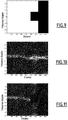
- Such a filtered temporal representation is represented on the figure 5
- the equivalent unfiltered temporal representation RT (obtained by the implementation of the method according to the prior art) is represented on the figure 4 .
- the filtered temporal representation RTF Downstream of the method 100, the filtered temporal representation RTF is used in the detection processing.
- the detection threshold which is applied to it is resensitized, in the sense that the level of the detection threshold can remain low, since the filtered temporal representation does not include parasitic echoes coming from the earth's surface and the number of detections used in the dynamic calculation of the threshold, therefore remains low.
- a second method 200 corresponding to a second embodiment of the treatment method according to the invention, will now be described with reference also to the figure 2 .
- This second method is specific to a coherent detection processing aimed at obtaining an RFF filtered frequency representation of the coastal zone observed by the radar in land / sea detection mode.
- the method 200 comprises a step 205 for time-frequency transformation, of the fast Fourier transform type, of the distance / recurrence samples E (d, rec) according to the recurrence dimension.
- Each distance / Doppler frequency sample E (d, ⁇ f ) thus obtained is associated with a cell, with abscissa d and ordinate ⁇ f , of a sampling frequency map.
- the method 200 comprises a step 210, similar to step 110, making it possible to express the information from the DEM file describing the coast of the coastal zone observed in a reference frame common to the distance / recurrence sampling time map of the signal.
- a transformed DEM file, in distance and recurrence, DEM (d, rec), is obtained.
- a time mask MT is initialized. It is made up of a matrix of cells with as many distance cells and recurrence cells as the sampling time map. Each cell of the temporal mask MT is associated with a binary value p (d, rec) equal to “1” when the entire surface corresponding to the cell considered in the transformed DEM file is a sea surface; and "0" when at least part of the cell surface in the transformed DEM file is a land surface.
- p d, rec
- the temporal mask MT is transformed according to a processing dimension, in this case the recurrent dimension, to obtain a smoothed temporal mask MTL.
- An MTL smoothed temporal mask is initialized. It consists of a matrix of cells with as many distance cells and recurrence cells as the temporal mask MT.
- the average value of the corresponding recurrence cells is calculated.
- this average value is equal to unity, that is to say if all the cells at this distance cell correspond to a sea surface, the value q (d, rec) of the cells of the smoothed temporal mask MTL for the distance box considered is equal to unity.
- this average value is zero, that is to say if all the cells in this distance box correspond to a land surface, the q (d, rec) value of the cells of the MTL smoothed temporal mask for this distance box is zero .
- this average value is between “0” and "1", that is to say if for this distance box, there are cells which correspond to a sea surface and others which correspond to a land surface, the value q (d, rec) of the cells of the smoothed temporal mask MTL for this distance cell take an intermediate value, for example 0.5.
- the smoothed temporal mask MTL constitutes a one-dimensional representation, in this case in distance.
- Step 224 then consists in obtaining a frequency mask MF with two dimensions distance / Doppler frequency from the smoothed temporal mask MTL.
- a frequency mask MF is initialized. It is made up of a matrix of cells with as many distance bins and Doppler frequency bins as the distance / Doppler frequency sampling frequency map of the signal.
- Each cell, with abscissa d and ordinate ⁇ f , of the frequency mask MF is associated with a value r (d, ⁇ f ).
- the value q (d, rec) of the smoothed temporal mask MTL is equal to "1" (respectively "0")
- the value q (d, ⁇ f ) of the cells of the frequency mask MF at this distance box are initialized to the value "1" (respectively "0").
- the value r (d, ⁇ f ) of the cells of the frequency mask MF at this distance box is initialized at the value "1" or to value "0" so as to eliminate the frequency footprint of the clutter of earth.
- the frequency footprint of the earth clutter is determined using values from the literature. Being generated by essentially static obstacles, the frequency footprint of the earth clutter is centered around the zero Doppler frequency. Thus, for such a distance box, the cells around the zero Doppler frequency take the value "0" to mask the clutter of earth, and the other cells take the value "1".
- a frequency mask MF obtained from the smoothed temporal mask MTL of the figure 7 is shown schematically on the figure 8 .
- the frequency mask MF produced in step 230 is then applied to the distance / Doppler frequency samples E (d, ⁇ f) so as to eliminate the parasitic echoes originating from the earth surface, in particular the earth clutter.
- a distance / frequency Doppler sample E (d, ⁇ f) is weighted by the value q (d, ⁇ f ) of the frequency mask MF.
- the filtered sample obtained is denoted Ef (d, ⁇ f).
- step 240 the calculation of the amplitude or of the squared amplitude of a filtered sample Ef (d, ⁇ f) leads to a filtered frequency representation RFF.
- Such a filtered frequency representation is represented on the figure 11 , while the equivalent unfiltered frequency representation is shown on the figure 10 .
- the representation of figure 11 was obtained using the frequency mask MF of the figure 9 , which derives from the temporal mask MT of the figure 3 .
- the filtered frequency representation RFF Downstream of the method 200, the filtered frequency representation RFF is used in a detection processing.
- the detection threshold applied to this representation is resensitized, that is to say that the level of the detection threshold remains low, since this representation contains no or few parasitic echoes caused by the earth's surface.
- the temporal mask could be applied to the distance / recurrence samples, then a fast Fourier transform applied to the filtered samples, to obtain distance / Doppler frequency samples.
- the number of distance / recurrence samples according to the application dimension of the fast Fourier transform may be insufficient to obtain a satisfactory frequency resolution.
- target detection as close as possible to the coast becomes problematic.
- the second method described above is then more advantageous since it makes it possible to respond to this problem.
- the main advantage of the present processing method is to resensitize the detection processing in land / sea detection mode, so as to be able to detect weak RES targets at the sea surface, and this as close as possible to the coasts.
Landscapes
- Engineering & Computer Science (AREA)
- Radar, Positioning & Navigation (AREA)
- Remote Sensing (AREA)
- Computer Networks & Wireless Communication (AREA)
- Physics & Mathematics (AREA)
- General Physics & Mathematics (AREA)
- Radar Systems Or Details Thereof (AREA)
Claims (9)
- Verfahren zur Verarbeitung (100) eines Digitalsignals (S(t)) eines elektronischen oder mechanischen Impuls- und Abtastradars während der Beobachtung eines Küstengebiets im Land/See-Überwachungsmodus, wobei das Signal gemäß einer zweidimensionalen Abtastungskarte abgetastet wird, wobei eine Dimension mit einem Abstand (d) vom Radar aus korrespondiert und die andere Dimension mit einem Wiederkehren (rec) der Abstrahlung des Impulses durch das Radar korrespondiert, wobei die zweidimensionale Abtastungskarte aus Abtastungen (E(d,rec)) gebildet ist, welche gekennzeichnet dadurch sind, dass das Verfahren zur Verarbeitung aufweist:- das Auswählen einer Datei eines digitalen Terrainmodells (MNT), welches mit dem beobachteten Küstengebiet korrespondiert,- das Transformieren (110) der Abtastungskarte und der Datei des digitalen Terrainmodells zum Erlangen einer transformierten Abtastungskarte und einer transformierten Datei des digitalen Terrainmodells, deren Daten in einem gemeinsamen Bezugssystem ausgedrückt sind,- das Erstellen (120) einer Zeitmaske (MT) durch Initialisieren einer Zeitmaske, welche eine Matrix aus Zellen aufweist, welche so viele Abstand-Felder und Wiederkehr-Felder aufweist wie die transformierte zeitliche Abtastungskarte, und durch Zuweisen, zu jeder Zelle der Zeitmaske, eines Werts (p(d,rec)), welcher vom Anteil der Landfläche auf der durch die Zelle begrenzten Fläche in der transformierten Datei des digitalen Terrainmodells abhängig ist, und- das Anwenden (130) der Zeitmaske auf die Abtastungen (E(d,rec)) der transformierten zeitlichen Abtastungskarte, um gefilterte Abtastungen (Ef(d,rec)) zu erlangen, wobei die Zeitmaske (MT) durch Gewichtung der Abtastung (E(d,rec)) einer Zelle der transformierten zeitlichen Abtastungskarte mittels des Werts (p(d,rec)) der Zelle, welche zu der Zeitmaske (MT) gehört, angewendet wird.
- Verfahren gemäß dem Anspruch 1, wobei der Wert (p(d,rec)) einer Zelle der Zeitmaske (MT) ein Binärwert ist, welcher den Wert Null annimmt, wenn die betrachtete Zelle eine Landfläche enthält, und den Wert eins annimmst, wenn die Zelle nur Meerfläche aufweist.
- Verfahren zur Verarbeitung (100) eines Digitalsignals (S(t)) eines elektronischen oder mechanischen Impuls- und Abtastradars während der Beobachtung eines Küstengebiets im Land/See-Überwachungsmodus, wobei das Signal gemäß einer zweidimensionalen Abtastungskarte abgetastet wird, wobei eine Dimension mit einem Abstand (d) vom Radar aus korrespondiert und die andere Dimension mit einem Wiederkehren (rec) der Abstrahlung des Impulses durch das Radar korrespondiert, wobei die zweidimensionale Abtastungskarte aus Abtastungen (E(d,rec)) gebildet ist, welche gekennzeichnet dadurch sind, dass das Verfahren zur Verarbeitung aufweist:- das Auswählen einer Datei eines digitalen Terrainmodells (MNT), welches mit dem beobachteten Küstengebiet korrespondiert,- das Transformieren (210) der Abtastungskarte und der Datei des digitalen Terrainmodells zum Erlangen einer transformierten Abtastungskarte und einer transformierten Datei des digitalen Terrainmodells, deren Daten in einem gemeinsamen Bezugssystem ausgedrückt sind,- das Anwenden eines Zeit-Frequenz-Transformationsschritts entlang der Wiederkehrrichtung auf die Abtastungen (E(d,rec)) der transformierten zeitlichen Abtastungskarte, um Abtastungen (E(d,Δf)) zu erlangen, welche zu einer zweidimensionalen Frequenz-Abtastungskarte gehören, wobei eine Dimension mit einem Abstand vom Radar korrespondiert und die andere Dimension mit einer Dopplerfrequenz der empfangenen Echos korrespondiert,- das Erstellen (220) einer Zeitmaske, welche eine Matrix aus Zellen aufweist, welche so viele Abstand-Felder und Wiederkehr-Felder aufweist wie die transformierte zeitliche Abtastungskarte, und Zuweisen, zu jeder Zelle der Zeitmaske, eines Werts (p(d,rec)), welcher vom Anteil der Landfläche auf der durch die Zelle begrenzten Fläche in der transformierten Datei des digitalen Terrainmodells abhängig ist,- das Glätten (222) der Zeitmaske (MT) entlang der Wiederkehrrichtung, um eine geglättete Zeitmaske (MTL) mit einer Dimension entlang der Abstandsrichtung zu erlangen,- das Ermitteln einer Frequenzmaske (MF) aus der geglätteten Zeitmaske (MTL), und- das Anwenden (230) der Frequenzmaske auf Abtastungen (E(d,Δf)) der Frequenz-Abtastungskarte, um gefilterte Abtastungen (Ef(d,Δf)) zu erlangen, wobei die Frequenzmaske (MF) durch Gewichtung des Werts jeder Abtastung (E(d,Δf)) mittels des Werts (r(d,Δf)) der Zelle, welche zu der Frequenzmaske (MF) gehört, angewendet wird, um die gefilterten Abtastungen (Ef(d,Δf)) zu erlangen.
- Verfahren gemäß dem Anspruch 3, wobei der Wert (p(d,rec)) einer Zelle der Zeitmaske (MT) ein Binärwert ist, welcher den Wert Null annimmt, wenn die betrachtete Zelle eine Landfläche enthält, und den Wert eins annimmst, wenn die Zelle nur Meerfläche aufweist, laut der transformierten Datei des digitalen Terrainmodells.
- Verfahren gemäß dem Anspruch 3 oder dem Anspruch 4, wobei die Zeitmaske (MT) entlang der Wiederkehr-Dimension geglättet wird durch Zuweisen des Werts (q(d,rec)) Eins zu den Zellen eines Abstand-Felds, wenn alle Werte (p(d,rec)) der Zellen der Zeitmaske für dieses Abstandsfeld gleich Eins sind, des Werts (q(d,rec)) Null, wenn alle Werte (p(d,rec)) der Zellen der Zeitmaske für dieses Abstandsfeld Null sind, und ansonsten eine dazwischenliegenden Werts (q(d,rec)).
- Verfahren gemäß dem Anspruch 5, wobei, zum Ermitteln der Frequenzmaske (MF) aus der geglätteten Zeitmaske (MTL), einer Zelle der gefilterten Frequenzmaske zugewiesen wird:- der Wert (r(d,Δf)) Eins, wenn die Zellen des Abstand-Felds, welches zu der geglätteten Zeitmaske gehört, den Wert (q(d,rec)) Eins haben,- der Wert (r(d,Δf)) Null, wenn die Zellen des Abstand-Felds, welches zu der geglätteten Zeitmaske gehört, den Wert (q(d,rec)) Null haben, und, ansonsten,- der Wert (r(d,Δf)) Null, falls diese Zelle mit einer Frequenzabdrucks eines Land-Clutters übereinstimmt, und der Wert (q(d,rec)) Eins, falls nicht.
- Verfahren gemäß irgendeinem der Ansprüche 1 bis 6, aufweisend einen Schritt des Berechnens einer gefilterten Zeit- und/oder Frequenz-Darstellung (RTF; RFF) aus den gefilterten Abtastungen (Ef(d,rec); Ef(d,Δf)).
- Vorrichtung zum Verarbeiten eines Signals eines elektronischen oder mechanischen Impuls- und Abtastradars, gekennzeichnet dadurch, dass sie Mittel zum Umsetzen eines Verfahrens zur Verarbeitung des Signals im Einklang mit irgendeinem der Ansprüche 1 bis 7 aufweist.
- Computerprogrammprodukt, aufweisend Anweisungen, welche dazu geeignet sind, durch einen Rechner einer Verarbeitungskette dazu ausgeführt zu werden, ein Verfahren zur Verarbeitung eines Signals eines elektronischen oder mechanischen Impuls- und Abtastradars gemäß irgendeinem der Ansprüche 1 bis 7 umzusetzen.
Applications Claiming Priority (2)
| Application Number | Priority Date | Filing Date | Title |
|---|---|---|---|
| FR1402433A FR3027698B1 (fr) | 2014-10-28 | 2014-10-28 | Procede de traitement du signal d'un radar en mode de detection terre/mer ; chaine de traitement et produit programme d'ordinateur associes |
| PCT/EP2015/074590 WO2016066540A1 (fr) | 2014-10-28 | 2015-10-23 | Procédé de traitement du signal d'un radar en mode de détection terre / mer; chaîne de traitement et produit programme d'ordinateur associés |
Publications (2)
| Publication Number | Publication Date |
|---|---|
| EP3213112A1 EP3213112A1 (de) | 2017-09-06 |
| EP3213112B1 true EP3213112B1 (de) | 2020-12-16 |
Family
ID=52684269
Family Applications (1)
| Application Number | Title | Priority Date | Filing Date |
|---|---|---|---|
| EP15787174.0A Active EP3213112B1 (de) | 2014-10-28 | 2015-10-23 | Verfahren zur verarbeitung eines radarsignals in einem land/see-detektionsmodus, verarbeitungssystem und zugehöriges computerprogrammprodukt |
Country Status (4)
| Country | Link |
|---|---|
| US (1) | US10591583B2 (de) |
| EP (1) | EP3213112B1 (de) |
| FR (1) | FR3027698B1 (de) |
| WO (1) | WO2016066540A1 (de) |
Families Citing this family (2)
| Publication number | Priority date | Publication date | Assignee | Title |
|---|---|---|---|---|
| FR3071066B1 (fr) | 2017-09-14 | 2019-08-23 | Thales | Procede de filtrage des echos de fouillis de sol et/ou de mer interceptes par un radar aeroporte, et radar mettant en oeuvre un tel procede |
| US20230128484A1 (en) * | 2021-06-02 | 2023-04-27 | General Radar Corporation | Intelligent radar systems and methods |
Family Cites Families (12)
| Publication number | Priority date | Publication date | Assignee | Title |
|---|---|---|---|---|
| US3680094A (en) * | 1966-04-04 | 1972-07-25 | North American Aviation Inc | Terrain-warning radar system |
| JPS495588A (de) * | 1972-05-04 | 1974-01-18 | ||
| US3831174A (en) * | 1973-02-05 | 1974-08-20 | Hughes Aircraft Co | Automatic target acquisition in mti radar system |
| FR2377640A1 (fr) * | 1977-01-18 | 1978-08-11 | Thomson Csf | Dispositif de stabilisation du taux de fausses alarmes dans un radar et systeme radar comportant un tel dispositif |
| US4233604A (en) * | 1978-11-27 | 1980-11-11 | Thomson-Csf | Receiver with fixed-echo suppressor |
| US5166692A (en) * | 1991-08-19 | 1992-11-24 | Loral Aerospace Corp. | Method and apparatus for adaptive radar environmental signal filtration |
| US6622118B1 (en) * | 2001-03-13 | 2003-09-16 | Alphatech, Inc. | System and method for comparing signals |
| US6885334B1 (en) * | 2004-04-06 | 2005-04-26 | Honeywell International Inc. | Methods and systems for detecting forward obstacles |
| FR2931952B1 (fr) * | 2008-05-30 | 2010-06-11 | Thales Sa | Procede d'elimination des echos de sol pour un radar meteorologique |
| EP2320247B1 (de) * | 2009-11-04 | 2017-05-17 | Rockwell-Collins France | Verfahren und System zur Detektion von Bodenhindernissen von einer schwebenden Plattform aus |
| JP5731800B2 (ja) * | 2010-11-19 | 2015-06-10 | 古野電気株式会社 | 物標探知方法、物標探知プログラム、物標探知装置、およびレーダ装置 |
| JP2014025916A (ja) * | 2012-06-21 | 2014-02-06 | Furuno Electric Co Ltd | 物標探知装置、およびエコー信号処理方法 |
-
2014
- 2014-10-28 FR FR1402433A patent/FR3027698B1/fr not_active Expired - Fee Related
-
2015
- 2015-10-23 US US15/521,077 patent/US10591583B2/en active Active
- 2015-10-23 EP EP15787174.0A patent/EP3213112B1/de active Active
- 2015-10-23 WO PCT/EP2015/074590 patent/WO2016066540A1/fr not_active Ceased
Non-Patent Citations (1)
| Title |
|---|
| L. YUAN ET AL: "DEM-based Watershed Topographic Attributes Extraction and Analysis", GEOSCIENCE AND REMOTE SENSING SYMPOSIUM, 2006. IGARSS 2006. IEEE INTER NATIONAL CONFERENCE ON, 1 July 2006 (2006-07-01), Pi, pages 911 - 913, XP055527150, ISBN: 978-0-7803-9510-7, DOI: 10.1109/IGARSS.2006.234 * |
Also Published As
| Publication number | Publication date |
|---|---|
| WO2016066540A1 (fr) | 2016-05-06 |
| FR3027698A1 (fr) | 2016-04-29 |
| US10591583B2 (en) | 2020-03-17 |
| FR3027698B1 (fr) | 2016-12-23 |
| EP3213112A1 (de) | 2017-09-06 |
| US20170343647A1 (en) | 2017-11-30 |
Similar Documents
| Publication | Publication Date | Title |
|---|---|---|
| EP2092366A1 (de) | Verfahren zur schätzung der höhe eines ballistischen projektils | |
| FR2940466A1 (fr) | Procede pour filtrer les echos radars produits par des eoliennes | |
| FR2971057A1 (fr) | Procede d'affichage de la surface equivalente radar minimale detectable | |
| EP3047298A1 (de) | Verfahren zur detektion von zielen und zugehöriger multifunktionsradar | |
| EP3457167B1 (de) | Filterverfahren der boden- und/oder see-störechos, die von einem radar an bord eines fluggeräts aufgefangen werden, und radar zur umsetzung eines solchen verfahrens | |
| Ouchi et al. | On the interpretation of synthetic aperture radar images of oceanic phenomena: Past and present | |
| EP1671152A1 (de) | Verfahren und einrichtung zum filtern von antworten in einem sekundär-radar-extraktor | |
| EP0752597B1 (de) | Polarimetrische Detektorschaltung für einen Radarempfänger | |
| EP3213112B1 (de) | Verfahren zur verarbeitung eines radarsignals in einem land/see-detektionsmodus, verarbeitungssystem und zugehöriges computerprogrammprodukt | |
| EP2544020B1 (de) | Verfahren und Vorrichtung zur Detektion eines Ziels, das von starken Energiereflektoren maskiert wird | |
| EP1776601A1 (de) | Cfar-verfahren durch statistische segmentierung und normalisierung | |
| FR2953939A1 (fr) | Systeme radar uhf pour mettre en oeuvre un procede d'elimination d'un fouillis de vegetation | |
| EP3485292B1 (de) | Verfahren und vorrichtung zur bestimmung einer geografischen, operationalen, durch einen sensor beobachteten zone | |
| EP3567399A1 (de) | Ortungsverfahren von zielen, insbesondere maritimen, und radar zur umsetzung dieses verfahrens | |
| EP2796893B1 (de) | Verfahren zum Ausblenden von Störechos bei der SAR-Bildgebung | |
| EP3236280B1 (de) | Automatische berechnung einer abmessung einer mobilen plattform | |
| FR3070768A1 (fr) | Procede de classification automatique d'un navire cible et systeme radar associe | |
| EP1812807B1 (de) | Wellenform-verwaltungsverfahren mit einer doppler-abbildung durch statistische segmentierung | |
| FR2550347A1 (fr) | Perfectionnements aux radars doppler a impulsions | |
| EP3657200B1 (de) | Erkennungsverfahren durch langzeitintegration, und entsprechendes radarsystem | |
| FR3072183A1 (fr) | Procede de detection de signaux radar | |
| FR3058530A1 (fr) | Procede de controle de la compatibilite electromagnetique d'un detecteur de radars avec au moins un emetteur de bord de signaux impulsionnels | |
| EP3575822A1 (de) | Bestimmungsverfahren einer charakteristischen abmessung eines schiffs | |
| Hadjal et al. | Detection potential of floating matter in high-resolution X-band SAR data: initial results with visual interpretations | |
| EP3538917B1 (de) | Verfahren zum testen der elektromagnetischen verträglichkeit eines radardetektors mit mindestens einem impulssignalgeber an bord |
Legal Events
| Date | Code | Title | Description |
|---|---|---|---|
| STAA | Information on the status of an ep patent application or granted ep patent |
Free format text: STATUS: THE INTERNATIONAL PUBLICATION HAS BEEN MADE |
|
| PUAI | Public reference made under article 153(3) epc to a published international application that has entered the european phase |
Free format text: ORIGINAL CODE: 0009012 |
|
| STAA | Information on the status of an ep patent application or granted ep patent |
Free format text: STATUS: REQUEST FOR EXAMINATION WAS MADE |
|
| 17P | Request for examination filed |
Effective date: 20170427 |
|
| AK | Designated contracting states |
Kind code of ref document: A1 Designated state(s): AL AT BE BG CH CY CZ DE DK EE ES FI FR GB GR HR HU IE IS IT LI LT LU LV MC MK MT NL NO PL PT RO RS SE SI SK SM TR |
|
| AX | Request for extension of the european patent |
Extension state: BA ME |
|
| DAV | Request for validation of the european patent (deleted) | ||
| DAX | Request for extension of the european patent (deleted) | ||
| STAA | Information on the status of an ep patent application or granted ep patent |
Free format text: STATUS: EXAMINATION IS IN PROGRESS |
|
| 17Q | First examination report despatched |
Effective date: 20181203 |
|
| GRAP | Despatch of communication of intention to grant a patent |
Free format text: ORIGINAL CODE: EPIDOSNIGR1 |
|
| STAA | Information on the status of an ep patent application or granted ep patent |
Free format text: STATUS: GRANT OF PATENT IS INTENDED |
|
| INTG | Intention to grant announced |
Effective date: 20200729 |
|
| GRAS | Grant fee paid |
Free format text: ORIGINAL CODE: EPIDOSNIGR3 |
|
| GRAA | (expected) grant |
Free format text: ORIGINAL CODE: 0009210 |
|
| STAA | Information on the status of an ep patent application or granted ep patent |
Free format text: STATUS: THE PATENT HAS BEEN GRANTED |
|
| AK | Designated contracting states |
Kind code of ref document: B1 Designated state(s): AL AT BE BG CH CY CZ DE DK EE ES FI FR GB GR HR HU IE IS IT LI LT LU LV MC MK MT NL NO PL PT RO RS SE SI SK SM TR |
|
| REG | Reference to a national code |
Ref country code: GB Ref legal event code: FG4D Free format text: NOT ENGLISH |
|
| REG | Reference to a national code |
Ref country code: DE Ref legal event code: R096 Ref document number: 602015063598 Country of ref document: DE |
|
| REG | Reference to a national code |
Ref country code: IE Ref legal event code: FG4D Free format text: LANGUAGE OF EP DOCUMENT: FRENCH |
|
| REG | Reference to a national code |
Ref country code: AT Ref legal event code: REF Ref document number: 1346096 Country of ref document: AT Kind code of ref document: T Effective date: 20210115 |
|
| PG25 | Lapsed in a contracting state [announced via postgrant information from national office to epo] |
Ref country code: RS Free format text: LAPSE BECAUSE OF FAILURE TO SUBMIT A TRANSLATION OF THE DESCRIPTION OR TO PAY THE FEE WITHIN THE PRESCRIBED TIME-LIMIT Effective date: 20201216 Ref country code: FI Free format text: LAPSE BECAUSE OF FAILURE TO SUBMIT A TRANSLATION OF THE DESCRIPTION OR TO PAY THE FEE WITHIN THE PRESCRIBED TIME-LIMIT Effective date: 20201216 Ref country code: NO Free format text: LAPSE BECAUSE OF FAILURE TO SUBMIT A TRANSLATION OF THE DESCRIPTION OR TO PAY THE FEE WITHIN THE PRESCRIBED TIME-LIMIT Effective date: 20210316 Ref country code: GR Free format text: LAPSE BECAUSE OF FAILURE TO SUBMIT A TRANSLATION OF THE DESCRIPTION OR TO PAY THE FEE WITHIN THE PRESCRIBED TIME-LIMIT Effective date: 20210317 |
|
| REG | Reference to a national code |
Ref country code: AT Ref legal event code: MK05 Ref document number: 1346096 Country of ref document: AT Kind code of ref document: T Effective date: 20201216 |
|
| REG | Reference to a national code |
Ref country code: NL Ref legal event code: MP Effective date: 20201216 |
|
| PG25 | Lapsed in a contracting state [announced via postgrant information from national office to epo] |
Ref country code: SE Free format text: LAPSE BECAUSE OF FAILURE TO SUBMIT A TRANSLATION OF THE DESCRIPTION OR TO PAY THE FEE WITHIN THE PRESCRIBED TIME-LIMIT Effective date: 20201216 Ref country code: LV Free format text: LAPSE BECAUSE OF FAILURE TO SUBMIT A TRANSLATION OF THE DESCRIPTION OR TO PAY THE FEE WITHIN THE PRESCRIBED TIME-LIMIT Effective date: 20201216 Ref country code: BG Free format text: LAPSE BECAUSE OF FAILURE TO SUBMIT A TRANSLATION OF THE DESCRIPTION OR TO PAY THE FEE WITHIN THE PRESCRIBED TIME-LIMIT Effective date: 20210316 |
|
| PG25 | Lapsed in a contracting state [announced via postgrant information from national office to epo] |
Ref country code: NL Free format text: LAPSE BECAUSE OF FAILURE TO SUBMIT A TRANSLATION OF THE DESCRIPTION OR TO PAY THE FEE WITHIN THE PRESCRIBED TIME-LIMIT Effective date: 20201216 Ref country code: HR Free format text: LAPSE BECAUSE OF FAILURE TO SUBMIT A TRANSLATION OF THE DESCRIPTION OR TO PAY THE FEE WITHIN THE PRESCRIBED TIME-LIMIT Effective date: 20201216 |
|
| REG | Reference to a national code |
Ref country code: LT Ref legal event code: MG9D |
|
| PG25 | Lapsed in a contracting state [announced via postgrant information from national office to epo] |
Ref country code: PT Free format text: LAPSE BECAUSE OF FAILURE TO SUBMIT A TRANSLATION OF THE DESCRIPTION OR TO PAY THE FEE WITHIN THE PRESCRIBED TIME-LIMIT Effective date: 20210416 Ref country code: SK Free format text: LAPSE BECAUSE OF FAILURE TO SUBMIT A TRANSLATION OF THE DESCRIPTION OR TO PAY THE FEE WITHIN THE PRESCRIBED TIME-LIMIT Effective date: 20201216 Ref country code: RO Free format text: LAPSE BECAUSE OF FAILURE TO SUBMIT A TRANSLATION OF THE DESCRIPTION OR TO PAY THE FEE WITHIN THE PRESCRIBED TIME-LIMIT Effective date: 20201216 Ref country code: LT Free format text: LAPSE BECAUSE OF FAILURE TO SUBMIT A TRANSLATION OF THE DESCRIPTION OR TO PAY THE FEE WITHIN THE PRESCRIBED TIME-LIMIT Effective date: 20201216 Ref country code: SM Free format text: LAPSE BECAUSE OF FAILURE TO SUBMIT A TRANSLATION OF THE DESCRIPTION OR TO PAY THE FEE WITHIN THE PRESCRIBED TIME-LIMIT Effective date: 20201216 Ref country code: CZ Free format text: LAPSE BECAUSE OF FAILURE TO SUBMIT A TRANSLATION OF THE DESCRIPTION OR TO PAY THE FEE WITHIN THE PRESCRIBED TIME-LIMIT Effective date: 20201216 Ref country code: EE Free format text: LAPSE BECAUSE OF FAILURE TO SUBMIT A TRANSLATION OF THE DESCRIPTION OR TO PAY THE FEE WITHIN THE PRESCRIBED TIME-LIMIT Effective date: 20201216 |
|
| PG25 | Lapsed in a contracting state [announced via postgrant information from national office to epo] |
Ref country code: PL Free format text: LAPSE BECAUSE OF FAILURE TO SUBMIT A TRANSLATION OF THE DESCRIPTION OR TO PAY THE FEE WITHIN THE PRESCRIBED TIME-LIMIT Effective date: 20201216 Ref country code: AT Free format text: LAPSE BECAUSE OF FAILURE TO SUBMIT A TRANSLATION OF THE DESCRIPTION OR TO PAY THE FEE WITHIN THE PRESCRIBED TIME-LIMIT Effective date: 20201216 |
|
| REG | Reference to a national code |
Ref country code: DE Ref legal event code: R097 Ref document number: 602015063598 Country of ref document: DE |
|
| PG25 | Lapsed in a contracting state [announced via postgrant information from national office to epo] |
Ref country code: IS Free format text: LAPSE BECAUSE OF FAILURE TO SUBMIT A TRANSLATION OF THE DESCRIPTION OR TO PAY THE FEE WITHIN THE PRESCRIBED TIME-LIMIT Effective date: 20210416 |
|
| PLBE | No opposition filed within time limit |
Free format text: ORIGINAL CODE: 0009261 |
|
| STAA | Information on the status of an ep patent application or granted ep patent |
Free format text: STATUS: NO OPPOSITION FILED WITHIN TIME LIMIT |
|
| PG25 | Lapsed in a contracting state [announced via postgrant information from national office to epo] |
Ref country code: AL Free format text: LAPSE BECAUSE OF FAILURE TO SUBMIT A TRANSLATION OF THE DESCRIPTION OR TO PAY THE FEE WITHIN THE PRESCRIBED TIME-LIMIT Effective date: 20201216 |
|
| 26N | No opposition filed |
Effective date: 20210917 |
|
| PG25 | Lapsed in a contracting state [announced via postgrant information from national office to epo] |
Ref country code: DK Free format text: LAPSE BECAUSE OF FAILURE TO SUBMIT A TRANSLATION OF THE DESCRIPTION OR TO PAY THE FEE WITHIN THE PRESCRIBED TIME-LIMIT Effective date: 20201216 |
|
| PG25 | Lapsed in a contracting state [announced via postgrant information from national office to epo] |
Ref country code: ES Free format text: LAPSE BECAUSE OF FAILURE TO SUBMIT A TRANSLATION OF THE DESCRIPTION OR TO PAY THE FEE WITHIN THE PRESCRIBED TIME-LIMIT Effective date: 20201216 |
|
| PG25 | Lapsed in a contracting state [announced via postgrant information from national office to epo] |
Ref country code: SI Free format text: LAPSE BECAUSE OF FAILURE TO SUBMIT A TRANSLATION OF THE DESCRIPTION OR TO PAY THE FEE WITHIN THE PRESCRIBED TIME-LIMIT Effective date: 20201216 |
|
| REG | Reference to a national code |
Ref country code: CH Ref legal event code: PL |
|
| PG25 | Lapsed in a contracting state [announced via postgrant information from national office to epo] |
Ref country code: IS Free format text: LAPSE BECAUSE OF FAILURE TO SUBMIT A TRANSLATION OF THE DESCRIPTION OR TO PAY THE FEE WITHIN THE PRESCRIBED TIME-LIMIT Effective date: 20210416 |
|
| REG | Reference to a national code |
Ref country code: BE Ref legal event code: MM Effective date: 20211031 |
|
| PG25 | Lapsed in a contracting state [announced via postgrant information from national office to epo] |
Ref country code: MC Free format text: LAPSE BECAUSE OF FAILURE TO SUBMIT A TRANSLATION OF THE DESCRIPTION OR TO PAY THE FEE WITHIN THE PRESCRIBED TIME-LIMIT Effective date: 20201216 |
|
| PG25 | Lapsed in a contracting state [announced via postgrant information from national office to epo] |
Ref country code: LU Free format text: LAPSE BECAUSE OF NON-PAYMENT OF DUE FEES Effective date: 20211023 Ref country code: BE Free format text: LAPSE BECAUSE OF NON-PAYMENT OF DUE FEES Effective date: 20211031 |
|
| PG25 | Lapsed in a contracting state [announced via postgrant information from national office to epo] |
Ref country code: LI Free format text: LAPSE BECAUSE OF NON-PAYMENT OF DUE FEES Effective date: 20211031 Ref country code: CH Free format text: LAPSE BECAUSE OF NON-PAYMENT OF DUE FEES Effective date: 20211031 |
|
| PG25 | Lapsed in a contracting state [announced via postgrant information from national office to epo] |
Ref country code: IE Free format text: LAPSE BECAUSE OF NON-PAYMENT OF DUE FEES Effective date: 20211023 |
|
| PG25 | Lapsed in a contracting state [announced via postgrant information from national office to epo] |
Ref country code: HU Free format text: LAPSE BECAUSE OF FAILURE TO SUBMIT A TRANSLATION OF THE DESCRIPTION OR TO PAY THE FEE WITHIN THE PRESCRIBED TIME-LIMIT; INVALID AB INITIO Effective date: 20151023 |
|
| P01 | Opt-out of the competence of the unified patent court (upc) registered |
Effective date: 20230502 |
|
| PG25 | Lapsed in a contracting state [announced via postgrant information from national office to epo] |
Ref country code: CY Free format text: LAPSE BECAUSE OF FAILURE TO SUBMIT A TRANSLATION OF THE DESCRIPTION OR TO PAY THE FEE WITHIN THE PRESCRIBED TIME-LIMIT Effective date: 20201216 |
|
| PG25 | Lapsed in a contracting state [announced via postgrant information from national office to epo] |
Ref country code: MK Free format text: LAPSE BECAUSE OF FAILURE TO SUBMIT A TRANSLATION OF THE DESCRIPTION OR TO PAY THE FEE WITHIN THE PRESCRIBED TIME-LIMIT Effective date: 20201216 |
|
| PG25 | Lapsed in a contracting state [announced via postgrant information from national office to epo] |
Ref country code: MT Free format text: LAPSE BECAUSE OF FAILURE TO SUBMIT A TRANSLATION OF THE DESCRIPTION OR TO PAY THE FEE WITHIN THE PRESCRIBED TIME-LIMIT Effective date: 20201216 |
|
| PG25 | Lapsed in a contracting state [announced via postgrant information from national office to epo] |
Ref country code: TR Free format text: LAPSE BECAUSE OF FAILURE TO SUBMIT A TRANSLATION OF THE DESCRIPTION OR TO PAY THE FEE WITHIN THE PRESCRIBED TIME-LIMIT Effective date: 20201216 |
|
| PGFP | Annual fee paid to national office [announced via postgrant information from national office to epo] |
Ref country code: DE Payment date: 20251015 Year of fee payment: 11 |
|
| PGFP | Annual fee paid to national office [announced via postgrant information from national office to epo] |
Ref country code: GB Payment date: 20251023 Year of fee payment: 11 |
|
| PGFP | Annual fee paid to national office [announced via postgrant information from national office to epo] |
Ref country code: IT Payment date: 20251007 Year of fee payment: 11 |
|
| PGFP | Annual fee paid to national office [announced via postgrant information from national office to epo] |
Ref country code: FR Payment date: 20251027 Year of fee payment: 11 |