EP3150963B1 - Indexing routes using similarity hashing - Google Patents
Indexing routes using similarity hashing Download PDFInfo
- Publication number
- EP3150963B1 EP3150963B1 EP16178893.0A EP16178893A EP3150963B1 EP 3150963 B1 EP3150963 B1 EP 3150963B1 EP 16178893 A EP16178893 A EP 16178893A EP 3150963 B1 EP3150963 B1 EP 3150963B1
- Authority
- EP
- European Patent Office
- Prior art keywords
- route
- link
- routes
- links
- server
- Prior art date
- Legal status (The legal status is an assumption and is not a legal conclusion. Google has not performed a legal analysis and makes no representation as to the accuracy of the status listed.)
- Active
Links
- 238000000034 method Methods 0.000 claims description 36
- 230000015654 memory Effects 0.000 claims description 35
- 230000006870 function Effects 0.000 claims description 34
- 238000004590 computer program Methods 0.000 claims description 11
- 230000004931 aggregating effect Effects 0.000 claims description 3
- 238000012935 Averaging Methods 0.000 claims 1
- 238000004891 communication Methods 0.000 description 19
- 238000013507 mapping Methods 0.000 description 7
- 238000012545 processing Methods 0.000 description 7
- 230000008569 process Effects 0.000 description 6
- 238000003860 storage Methods 0.000 description 5
- 230000003287 optical effect Effects 0.000 description 4
- 230000003068 static effect Effects 0.000 description 4
- 238000004422 calculation algorithm Methods 0.000 description 3
- 230000006855 networking Effects 0.000 description 3
- 230000008439 repair process Effects 0.000 description 3
- 230000000007 visual effect Effects 0.000 description 3
- 230000005540 biological transmission Effects 0.000 description 2
- 230000001413 cellular effect Effects 0.000 description 2
- 238000009826 distribution Methods 0.000 description 2
- 230000003993 interaction Effects 0.000 description 2
- 239000004973 liquid crystal related substance Substances 0.000 description 2
- 230000008520 organization Effects 0.000 description 2
- 238000013515 script Methods 0.000 description 2
- 238000010845 search algorithm Methods 0.000 description 2
- 238000000926 separation method Methods 0.000 description 2
- 230000009466 transformation Effects 0.000 description 2
- 238000012952 Resampling Methods 0.000 description 1
- 230000002776 aggregation Effects 0.000 description 1
- 238000004220 aggregation Methods 0.000 description 1
- 238000003491 array Methods 0.000 description 1
- 230000003796 beauty Effects 0.000 description 1
- 230000009286 beneficial effect Effects 0.000 description 1
- 230000008901 benefit Effects 0.000 description 1
- 230000006835 compression Effects 0.000 description 1
- 238000007906 compression Methods 0.000 description 1
- 238000001514 detection method Methods 0.000 description 1
- 230000000694 effects Effects 0.000 description 1
- 238000005457 optimization Methods 0.000 description 1
- 230000002441 reversible effect Effects 0.000 description 1
- 238000005070 sampling Methods 0.000 description 1
- 239000004065 semiconductor Substances 0.000 description 1
- 230000001953 sensory effect Effects 0.000 description 1
- 238000012360 testing method Methods 0.000 description 1
- 239000010409 thin film Substances 0.000 description 1
- 238000012546 transfer Methods 0.000 description 1
- 230000007704 transition Effects 0.000 description 1
- 239000013598 vector Substances 0.000 description 1
- 238000005303 weighing Methods 0.000 description 1
Images


Classifications
-
- G—PHYSICS
- G01—MEASURING; TESTING
- G01C—MEASURING DISTANCES, LEVELS OR BEARINGS; SURVEYING; NAVIGATION; GYROSCOPIC INSTRUMENTS; PHOTOGRAMMETRY OR VIDEOGRAMMETRY
- G01C21/00—Navigation; Navigational instruments not provided for in groups G01C1/00 - G01C19/00
- G01C21/26—Navigation; Navigational instruments not provided for in groups G01C1/00 - G01C19/00 specially adapted for navigation in a road network
- G01C21/34—Route searching; Route guidance
- G01C21/3407—Route searching; Route guidance specially adapted for specific applications
- G01C21/343—Calculating itineraries, i.e. routes leading from a starting point to a series of categorical destinations using a global route restraint, round trips, touristic trips
-
- G—PHYSICS
- G01—MEASURING; TESTING
- G01C—MEASURING DISTANCES, LEVELS OR BEARINGS; SURVEYING; NAVIGATION; GYROSCOPIC INSTRUMENTS; PHOTOGRAMMETRY OR VIDEOGRAMMETRY
- G01C21/00—Navigation; Navigational instruments not provided for in groups G01C1/00 - G01C19/00
- G01C21/26—Navigation; Navigational instruments not provided for in groups G01C1/00 - G01C19/00 specially adapted for navigation in a road network
- G01C21/34—Route searching; Route guidance
-
- G—PHYSICS
- G06—COMPUTING; CALCULATING OR COUNTING
- G06F—ELECTRIC DIGITAL DATA PROCESSING
- G06F16/00—Information retrieval; Database structures therefor; File system structures therefor
- G06F16/30—Information retrieval; Database structures therefor; File system structures therefor of unstructured textual data
- G06F16/31—Indexing; Data structures therefor; Storage structures
- G06F16/316—Indexing structures
- G06F16/325—Hash tables
-
- G—PHYSICS
- G06—COMPUTING; CALCULATING OR COUNTING
- G06F—ELECTRIC DIGITAL DATA PROCESSING
- G06F16/00—Information retrieval; Database structures therefor; File system structures therefor
- G06F16/30—Information retrieval; Database structures therefor; File system structures therefor of unstructured textual data
- G06F16/33—Querying
- G06F16/335—Filtering based on additional data, e.g. user or group profiles
- G06F16/337—Profile generation, learning or modification
-
- G—PHYSICS
- G01—MEASURING; TESTING
- G01C—MEASURING DISTANCES, LEVELS OR BEARINGS; SURVEYING; NAVIGATION; GYROSCOPIC INSTRUMENTS; PHOTOGRAMMETRY OR VIDEOGRAMMETRY
- G01C21/00—Navigation; Navigational instruments not provided for in groups G01C1/00 - G01C19/00
- G01C21/26—Navigation; Navigational instruments not provided for in groups G01C1/00 - G01C19/00 specially adapted for navigation in a road network
- G01C21/28—Navigation; Navigational instruments not provided for in groups G01C1/00 - G01C19/00 specially adapted for navigation in a road network with correlation of data from several navigational instruments
- G01C21/30—Map- or contour-matching
-
- G—PHYSICS
- G01—MEASURING; TESTING
- G01C—MEASURING DISTANCES, LEVELS OR BEARINGS; SURVEYING; NAVIGATION; GYROSCOPIC INSTRUMENTS; PHOTOGRAMMETRY OR VIDEOGRAMMETRY
- G01C21/00—Navigation; Navigational instruments not provided for in groups G01C1/00 - G01C19/00
- G01C21/26—Navigation; Navigational instruments not provided for in groups G01C1/00 - G01C19/00 specially adapted for navigation in a road network
- G01C21/34—Route searching; Route guidance
- G01C21/3446—Details of route searching algorithms, e.g. Dijkstra, A*, arc-flags, using precalculated routes
-
- G—PHYSICS
- G01—MEASURING; TESTING
- G01C—MEASURING DISTANCES, LEVELS OR BEARINGS; SURVEYING; NAVIGATION; GYROSCOPIC INSTRUMENTS; PHOTOGRAMMETRY OR VIDEOGRAMMETRY
- G01C21/00—Navigation; Navigational instruments not provided for in groups G01C1/00 - G01C19/00
- G01C21/26—Navigation; Navigational instruments not provided for in groups G01C1/00 - G01C19/00 specially adapted for navigation in a road network
- G01C21/34—Route searching; Route guidance
- G01C21/3453—Special cost functions, i.e. other than distance or default speed limit of road segments
- G01C21/3461—Preferred or disfavoured areas, e.g. dangerous zones, toll or emission zones, intersections, manoeuvre types, segments such as motorways, toll roads, ferries
-
- G—PHYSICS
- G01—MEASURING; TESTING
- G01C—MEASURING DISTANCES, LEVELS OR BEARINGS; SURVEYING; NAVIGATION; GYROSCOPIC INSTRUMENTS; PHOTOGRAMMETRY OR VIDEOGRAMMETRY
- G01C21/00—Navigation; Navigational instruments not provided for in groups G01C1/00 - G01C19/00
- G01C21/26—Navigation; Navigational instruments not provided for in groups G01C1/00 - G01C19/00 specially adapted for navigation in a road network
- G01C21/34—Route searching; Route guidance
- G01C21/3453—Special cost functions, i.e. other than distance or default speed limit of road segments
- G01C21/3469—Fuel consumption; Energy use; Emission aspects
-
- G—PHYSICS
- G01—MEASURING; TESTING
- G01C—MEASURING DISTANCES, LEVELS OR BEARINGS; SURVEYING; NAVIGATION; GYROSCOPIC INSTRUMENTS; PHOTOGRAMMETRY OR VIDEOGRAMMETRY
- G01C21/00—Navigation; Navigational instruments not provided for in groups G01C1/00 - G01C19/00
- G01C21/26—Navigation; Navigational instruments not provided for in groups G01C1/00 - G01C19/00 specially adapted for navigation in a road network
- G01C21/34—Route searching; Route guidance
- G01C21/3453—Special cost functions, i.e. other than distance or default speed limit of road segments
- G01C21/3484—Personalized, e.g. from learned user behaviour or user-defined profiles
-
- G—PHYSICS
- G01—MEASURING; TESTING
- G01C—MEASURING DISTANCES, LEVELS OR BEARINGS; SURVEYING; NAVIGATION; GYROSCOPIC INSTRUMENTS; PHOTOGRAMMETRY OR VIDEOGRAMMETRY
- G01C21/00—Navigation; Navigational instruments not provided for in groups G01C1/00 - G01C19/00
- G01C21/26—Navigation; Navigational instruments not provided for in groups G01C1/00 - G01C19/00 specially adapted for navigation in a road network
- G01C21/34—Route searching; Route guidance
- G01C21/36—Input/output arrangements for on-board computers
- G01C21/3605—Destination input or retrieval
- G01C21/3611—Destination input or retrieval using character input or menus, e.g. menus of POIs
-
- G—PHYSICS
- G01—MEASURING; TESTING
- G01C—MEASURING DISTANCES, LEVELS OR BEARINGS; SURVEYING; NAVIGATION; GYROSCOPIC INSTRUMENTS; PHOTOGRAMMETRY OR VIDEOGRAMMETRY
- G01C21/00—Navigation; Navigational instruments not provided for in groups G01C1/00 - G01C19/00
- G01C21/26—Navigation; Navigational instruments not provided for in groups G01C1/00 - G01C19/00 specially adapted for navigation in a road network
- G01C21/34—Route searching; Route guidance
- G01C21/36—Input/output arrangements for on-board computers
- G01C21/3667—Display of a road map
- G01C21/367—Details, e.g. road map scale, orientation, zooming, illumination, level of detail, scrolling of road map or positioning of current position marker
-
- G—PHYSICS
- G06—COMPUTING; CALCULATING OR COUNTING
- G06F—ELECTRIC DIGITAL DATA PROCESSING
- G06F16/00—Information retrieval; Database structures therefor; File system structures therefor
-
- G—PHYSICS
- G06—COMPUTING; CALCULATING OR COUNTING
- G06F—ELECTRIC DIGITAL DATA PROCESSING
- G06F16/00—Information retrieval; Database structures therefor; File system structures therefor
- G06F16/20—Information retrieval; Database structures therefor; File system structures therefor of structured data, e.g. relational data
- G06F16/29—Geographical information databases
-
- G—PHYSICS
- G06—COMPUTING; CALCULATING OR COUNTING
- G06F—ELECTRIC DIGITAL DATA PROCESSING
- G06F3/00—Input arrangements for transferring data to be processed into a form capable of being handled by the computer; Output arrangements for transferring data from processing unit to output unit, e.g. interface arrangements
- G06F3/01—Input arrangements or combined input and output arrangements for interaction between user and computer
- G06F3/03—Arrangements for converting the position or the displacement of a member into a coded form
- G06F3/041—Digitisers, e.g. for touch screens or touch pads, characterised by the transducing means
-
- G—PHYSICS
- G09—EDUCATION; CRYPTOGRAPHY; DISPLAY; ADVERTISING; SEALS
- G09B—EDUCATIONAL OR DEMONSTRATION APPLIANCES; APPLIANCES FOR TEACHING, OR COMMUNICATING WITH, THE BLIND, DEAF OR MUTE; MODELS; PLANETARIA; GLOBES; MAPS; DIAGRAMS
- G09B29/00—Maps; Plans; Charts; Diagrams, e.g. route diagram
- G09B29/10—Map spot or coordinate position indicators; Map reading aids
- G09B29/106—Map spot or coordinate position indicators; Map reading aids using electronic means
Definitions
- the following disclosure relates to routing and navigation systems.
- Navigational systems are used to map out routes from a starting point to a destination point. Routes are generally created from a list of road links or nodes. A typical navigational system offers a user several choices for which route to take. These choices generally include the shortest distance, the quickest transit time, or the least expensive (e.g., toll avoidance).
- Navigational systems can create routes based on the shortest distance or time in part due to algorithms such as the traveling salesperson problem or other optimization. Navigational systems may also provide additional information such as landmarks and or traffic conditions (for example lights / stop signs etc.). Navigational systems contain millions of road links and nodes from which routes may be generated. The number of routes that are possible is impossibly large.
- US 2015/0066355 A1 relates to a routing application which performs operations including: identifying a contextual parameter indicative of a quality preference for routing over segments of geographic mapping data; weighing the segments according to traffic score information indicative of the presence of the contextual parameter over the respective segments as determined based at least in part on vehicle diagnostic data; and determining a suggested route for a vehicle from a current location to a destination location over the weighed segments based on the contextual parameter.
- US '355 also relates to using learning heuristics to identify which diagnostic data variables correlate with the presence of which contextual parameters.
- a computer-implemented method as claimed in Claim 1 there is provided a computer-implemented method as claimed in Claim 1.
- a computer-implemented method comprising:identifying a plurality of routes (A,B), wherein each route includes one or more respective links;identifying a route attribute, wherein the route attribute describes each of the plurality of routes;generating (S201) a plurality of indexes (501) of minimum links with associated route attribute values, each index corresponding to the identified route attribute and a different respective injective hash function, and each index being generated by:for each of the plurality of routes (A, B):- hashing (S105) the one or more links using the respective injective hash function to generate a hash value for each link;- determining the link having the minimum hash value to be the minimum link; and-assigning (S107) the route attribute to the determined minimum link, and for each of the determined minimum links, aggregating the number of routes for which that link was determined to be the minimum link as the route attribute value for that link.
- the route attribute may be a popularity of the route.
- the route attribute may be a scenic value of the route.
- the route attribute may be received from a user profile.
- the route attribute may be received from a social media application.
- an apparatus comprising:
- Non-transitory computer readable medium including instructions that when executed are operable to perform a method as recited above.
- the shortest route (or least expensive) is not always the preferred route for every user.
- a user may prefer a scenic route to work or may be on vacation and not be in a rush.
- Routes such as these may be found in a guide book or discovered by chance.
- These routes may be also be tagged or described by individual users. Routes may be rated by different users or labeled with certain attributes such as "no traffic" or "scenic".
- These routes are static and cannot be altered or updated without potentially losing their value to a user.
- These routes must have static starting points, static destination points, and contain the same segments from one description to another description.
- These routes are also limited in their coverage as they may only describe a few out of the infinite number of potential routes.
- These routes are also not scored or ranked and as such, a search for a "no traffic" or "scenic" route may return multiple results with no clear difference.
- Users may recommend certain routes they drive for a certain purpose. For example, a user might just have driven a certain route and recommend it as “scenic” or nice for “bicycles", or just “preferred in general (popular)". Later, a second user asks for a "scenic” or "bicycle-nice” or “popular” between A and B. If the route is the exact same route as the original route, the second user may be able to search for a recommendation from the first user. If the second user is looking for a route that does not have the same destination and starting point as the original route, the first user's recommendation will not be returned in a search.
- the following embodiments include systems and methods for indexing of routes using similarity hashing.
- An index may be created using minimum hashing.
- An index may be queried by minimum hashing and returning route attributes.
- a route may be created with the route attributes and an index of hashed links.
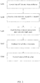
- Figure 1 illustrates a method for indexing of routes using similarity hashing.
- the acts may be performed using any combination of the components indicated in Figure 7 , Figure 8 , or Figure 9 .
- the following acts may be performed by a server 125, device 122, or a combination thereof. Additional, different, or fewer acts may be provided.
- the acts are performed in the order shown or other orders. The acts may also be repeated.
- a server 125 identifies a route.
- the term server 125 is used herein to collectively include the computing devices in a navigation system 121 for creating, maintaining, accessing, and updating a database(s) 123.
- the server 125 may be a host for a website or web service such as a mapping service and/or a navigation service.
- the mapping service may provide maps generated from the geographic data of the database 123, and the navigation service may generate routing or other directions from the geographic data of the database 123. Additional, different, or fewer components may be included.
- the terms database and map database refer to a set of data or map data stored in a storage medium and may not necessarily reflect specific requirements as to the relational organization of the data or the map data.
- the database 123 may be a geographic database including road links and road attributes.
- the database may also contain one or more indexes.
- the route may be stored in memory or transmitted to the server 125.
- the route may be a set of road links (or links or road segments) between a starting point and a destination.
- the route may be generated from or stored within a database 123 or map database.
- the database 123 may include geographic data used for traffic and/or navigation-related applications.
- the geographic data may include data representing a road network or system including road link data and node data.
- the road link data represent roads, and the node data represent the ends or intersections of the roads.
- the road link data and the node data indicate the location of the roads and intersections as well as various attributes of the roads and intersections. Other formats than road links and nodes may be used for the geographic data.
- the geographic data may include structured cartographic data or pedestrian routes.
- the route identified may be a route that was transmitted by a device.
- the device may use positional circuitry to track the progress of a trip or route.
- the route may also be a route that has been stored in memory or manually inputted into the device.
- the route may be transmitted to the server 125 over a network 127. Multiple routes may be also be transmitted by the device.
- the device may be a smart phone, a mobile phone, a personal digital assistant (PDA), a tablet computer, a notebook computer, a personal navigation device (PND), a portable navigation device, and/or any other known or later developed mobile device.
- the device may have inputs for users to specify a destination. Data including an address or destination may be entered through a keypad, touchpad, touchscreen, microphone or other device input.
- a device location may be derived using positional circuitry within the device such as GPS or GNSS or the device location may be entered using a device input.
- the server 125 identifies one or more route attributes.
- the route attribute may be stored in memory 301 or the database 123.
- the route attribute may be collected or received from a device through a network 127.
- the route attribute may be anything that describes or adds additional data to the route.
- Route attributes may include facts or physical descriptions of the routs such as, for example, geographic coordinates, street names, address ranges, speed limits, turn restrictions at intersections, and/or other navigation related attributes (e.g., one or more of the road links is part of a highway or toll way, the location of stop signs and/or stoplights along the road links), as well as points of interest (POIs), such as gasoline stations, hotels, restaurants, museums, stadiums, offices, automobile dealerships, auto repair shops, buildings, stores, parks, etc.
- POIs points of interest
- Route attributes may also include opinions, annotations or user created observations such as scenic, windy, pretty, ugly, gritty, beautiful, slow, fast, bumpy, muddy, etc.
- Other observations may include views of a blank (where blank could be a lighthouse, historical buildings, POI, natural beauty etc.), wildlife or other natural observations, or activities such as great shopping, antiques, good food, etc.
- Route attributes may also include data previously stored or collected.
- Personal navigation devices or devices in general may include profiles of the users. Data may include age, nationality, preferences, etc. This data may be included as route attribute and may be useful to help generate a preferred route (for instance a route that is taken by younger users more than older users).
- the route attribute may also be received from a social application.
- a device running an application such as a microblog website, social networking application, an instant message (IM) service, or other social application may collect data as the device starts, finishes, or travels a route.
- the device using positional circuity may associate this data with a road link or route.
- This data may then be transmitted to the server 125 as a route attribute.
- Receiving, collecting, or identifying route attributes from a social application may be beneficial to providing social navigation through a personal navigation device or autonomous vehicle.
- the route attribute may also be received, collected, or identified from a website or web posting. Feeds, blogs, bulletin boards, forum, and other websites may identify a route and a route attribute.
- the server 125 may crawl, scan, or receive data from these sources and use this data as a route attribute.
- the source may be varied.
- the server 125 may collect, receive, or identify a route attribute from multiple different sources. For example, a user may state on a forum that a route the user took was "beautiful". A second user may send an instant message while traveling the route that mentioned the "awesome views”. A third user may be prompted by a personal navigation device to rate a bicycle trip or drive. The third user's entry of "scenic" might be collected by the server 125 along with the remarks by the first and second users. This data may be aggregated into a single route attribute of "scenic" or the server 125 may separate each description into a different route attribute. Route attributes may also be distinct for a mode of travel such as by motorized vehicle, bicycle, motorcycle, by foot, among other modes of travel.
- the one or more route attributes identified by the server 125 is that of a scenic value of a route.
- the server 125 has identified the route (and the links that make up the route) and a route attribute.
- the route may be compared to all other routes that have been considered scenic. How similar the route is to these stored scenic routes will determine the scenic value.
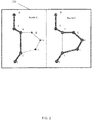
- Figure 2 illustrates a two versions of a map 250 with two routes A and B.
- the starting point is D; the destination is K.
- the link GH is the path between nodes G and H.
- There are two routes shown outlined. Route A on the left is more of a direct route and encompasses the links DE, EF, FI, and JK.
- Route B on the right is a bit longer, and encompasses the links DE, EF, FG, GH, HI, IJ, and JK.
- the processor 300 is configured to use a big set of routes called scenic that may have been collected as all the routes users recommended as scenic.
- the server 125 may measure its value to be how similar it is to all the routes users recommended as scenic.
- the server 125 sums up the similarity of the route R to all routes that are called scenic and define this to be the scenic value of R.
- This solution while mathematically not complex is very expensive (e.g., with respect to time, repetition, or computing resources) to process.
- There are millions of road links and the potential combinations to create different routes are endless. To have to compare each route to all other routes would potentially require hours or days of processing time. A quicker technique exists through hashing the links that make up the route.
- Hashing is the transformation of a string of characters into a usually shorter fixed-length value or key that represents the original string. Hashing is used to index and retrieve items in a database 123 because it is faster to find the item using the shorter hashed key than to find it using the original value.
- a hash function H projects a value from a set with many (or even an infinite number of) members to a value from a set with a fixed number of (fewer) members. Hash functions may not be reversible.
- the hash function may store an output in a hash table.
- a hash function may be perfect in that it maps distinct elements with no collusions.
- a hash function for an embodiment may or may not be perfect.
- the server 125 defines h to be a random, but fixed injective hash function, that hashes a link i to some real number h ( i ) between 0 and 1.
- the probability for a random hash function for the minimum-hash values of two sets A and B to collide equals to the size of the intersection divided by the size of the union of the two sets A and B.
- the server 125 defines v h ( i ) to be the number of all scenic routes S that have i as the minimizing link with respect to h.
- v h i : S
- h S i
- v h ( i ) is a random value with respect to the same underlying probability space.
- the route attribute for example scenic, is assigned to the minimum link.
- an index of links and route attributes is generated.
- the server 125 identifies the scenic routes, hashes the links, computes the link that has the minimum hash and then aggregates the number of such "hits" for each link, i.e. how much of the route attribute was assigned to the link as the route attribute value for that link. Indexes may be created for multiple route attributes.
- the value may scatter a bit.
- multiple independent hash-functions and multiple independent indexes may be used. The average of these indexes may give a better estimate than a single pass through a single hash function.
- the quality of the estimate may be computed using the standard error of the mean, Jackknife or Bootstrapping.
- Standard error of the mean is a method to compute how far an estimated mean differs from the true mean.
- Jackknife is a resampling technique especially useful for variance and bias estimation.
- Bootstrapping may refer to any test or metric that relies on random sampling with replacement. Bootstrapping allows assigning measures of accuracy (defined in terms of bias, variance, confidence intervals, prediction error or some other such measure) to sample estimates.
- the method in Figure 1 is repeated with different hash-functions. Different hash-functions will return different minimum values for the links; averaged together the aggregate of the number of "hits" will give a better estimate for the route attribute.
- ten or more different hash-functions are used to create ten or more independent indexes. The ten or more independent indexes are then averaged to provide a single master index.
- Figure 3 illustrates a method for querying an index for a route attribute, for example scenic routes.
- the acts may be performed using any combination of the components indicated in Figure 7 , Figure 8 , or Figure 9 .
- the following acts may be performed by a server 125, device 122, or a combination thereof. Additional, different, or fewer acts may be provided.
- the acts are performed in the order shown or other orders. The acts may also be repeated.
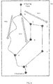
- Figure 4 illustrates a map 401 with three example routes R301, R303, R305 and multiple links (AB, BC, CE, EF, FG, GJ, BH, CD, DH, HG).
- Figure 5 illustrates an example of an index which includes links from Figure 4 and a value for route attribute 1 and route attribute 2.
- an index is created including one or more links and an aggregation of a route attribute.
- an index may be created by going through one or more routes, computing the link that has the minimum hash and aggregating the number of hits for each link as the route attribute value for that link.
- Figure 5 illustrates an example index.
- Figure 5 includes an index with fields for a link, a link ref number, a link hash value, a route attribute value 1 and a route attribute value 2.
- An index may not include the link name, but rather just refer to the link as the link ref number.
- the index in Figure 5 lists the links from Figure 4 in the link column.
- the index or indexes may be stored in memory 301 or in the database 123.
- the server 125 receives a route attribute request regarding a second route.
- the second route includes a number of road links.
- the request may contain the road links, or the server 125 may query the database 123 to determine which road links are included within the second route.
- Figure 4 illustrates three routes R301, R303, and R305.
- Each route R301, R303, and R305 are made up of a series of links.
- R301 includes links AB, BH, HG, and GJ.
- R303 includes AB, BC, CD, DH, HG, and GJ.
- R305 includes AB, BC, CE, EF, FG, and GJ.
- R301 will represent the second route.
- the server 125 hashes the links included in the second route.
- the server 125 defines h to be a random, but fixed injective hash function, that hashes a link i to some real number h ( i ) between 0 and 1.
- the hash function in the query process is the same hash function that was used in the index generation process.
- the index in Figure 5 illustrates the hash values for multiple links.
- the links AB, BH, HG, and GJ will be hashed.
- the hash values for these links are .2200, .0524, .8930, .6553 respectively.
- the minimum-hash for the second route is .0524 which corresponds to BH.
- the minimum link BH (that is representative of the minimum hash value) is looked up in the index.
- the index may list a route attribute value for the minimum link. As illustrated by Figure 5 , the index shows that the value for route attribute 1 (scenic in this example) is eight.
- the route attribute value is transmitted to the device.
- the route attribute is eight.
- the value may represent how similar a route is to other routes which have been described or labeled by the route attribute. Different value scales may be used for different route attributes. A lower value may be better than a higher score. In the example illustrated by Figures 3-5 , a higher scenic value was preferred. In a different embodiment, a lower value such as how bumpy a route is may be preferred.
- the device may ascertain the properties of a selected route. If the device does not have a known route, but a starting point and a destination, the device may request a route from the server 125 that meets a requested route attribute.
- Figure 6 illustrates a method for finding a route that is similar to other routes, for example scenic routes.
- the acts may be performed using any combination of the components indicated in Figure 7 , Figure 8 , or Figure 9 .
- the following acts may be performed by a server 125, device 122, or a combination thereof. Additional, different, or fewer acts may be provided. The acts are performed in the order shown or other orders. The acts may also be repeated.
- the server 125 may find the route with the highest scenic value. As mentioned above, the server 125 may compute the scenic value of a route by querying an index. In order to find the route with the highest scenic value, the server 125 may use a gradient local search.
- the server 125 creates an index including links and a route attribute.
- Figure 4 illustrates three example routes and multiple links.
- Figure 5 illustrates an example of an index which includes links from Figure 4 .
- Figure 5 includes an index 501 with fields for a link, a link ref no., a link hash value, a route attribute value 1 and a route attribute value 2.
- An index may not include the link name, but rather just refer to the link as the link ref no.
- the index in Figure 5 lists the links from Figure 4 in the link column.
- the server 125 receives a request for a route.
- the request for a route includes a starting point and a destination.
- Figure 4 illustrates a starting point A and a destination J.
- the request also includes a route attribute.
- the route attribute may be the scenic value of a route.
- the server 125 creates one or more candidate routes.
- the candidate route may be generated from or stored within a database 123.
- the database 123 may include geographic data used for traffic and/or navigation-related applications.
- the geographic data may include data representing a road network or system including road link data and node data.
- the road link data represent roads, and the node data represent the ends or intersections of the roads.
- Figure 4 illustrates ten links (AB, BC, CD, CE, EF, GF, DH, BH, HG, and GJ).
- R301 includes links AB, BH, HG, and GJ.
- R303 includes AB, BC, CD, DH, HG, and GJ.
- R305 includes AB, BC, CE, EF, FG, and GJ.
- the server 125 hashes the links that make up the candidate route.
- the server 125 may use a hash function as mentioned above to return the following respective values for the links AB, BC, CE, EF, FG, and GJ: .2200, .0330, .0111, .6790, .9343, .6553.
- the minimum hash for R305 is .0111 (link CE).
- Link CE is queried in the index which returns a value of one for route attribute one.
- the acts S305, S307, and S309 are repeated.
- the server 125 may generate a different candidate route.
- the second candidate route may be R303 which is made up of links AB, BC, CD, DH, HG, and GJ.
- the server 125 hashes the links to return the following values: .2200, .0330, .4500, .0443, .8930, and .6553.
- the minimum hash for R303 is .0330 (link BC).
- Link BC is looked up in the index which returns a value of one for route attribute one.
- the server 125 may then select a different candidate route.
- the third candidate route may be R301.
- R301 contains links AB, BH, HG, and GJ, which when hashed return the hash values of .2200, .0524, .8930, and .6553 respectively.
- the minimum hash for R301 is .0524 (Link BH).
- Link BH is looked up in the index which returns a value of eight for route attribute one.
- the server 125 may then select a different candidate route until all potential routes are exhausted or the server 125 reaches a predefined limit.
- the server 125 may use a gradient search strategy to limit the number of candidate routes.
- the server 125 may use multiple types of search strategies to limit the number of candidate routes to be calculated.
- the server 125 transmits the candidate route which has the highest (or most) route attribute.
- the candidate route which has the highest route attribute is R301. This may indicate that R301 is most similar of the candidate routes to routes that have described or marked as being scenic (if route attribute one represents scenic value).
- the server 125 may not select the candidate route which has the highest route attribute value. For example, the most popular route is very similar to the fastest route. Hence, as a start point for the local search, the server 125 selects the fastest route (or as an alternative one of the alternative almost fastest routes).
- a search algorithm may blacklist each of the links of the current route one-by-one and re-compute the fastest route avoiding that link and compute its scenic.
- the server 125 selects the blacklisted link where the scenic value grows the biggest and keep that blacklisted link also to be avoided in any succeeding search step.
- the server 125 stops the search when it returns a solution where blacklisting a link does not improve the scenic value anymore.
- the search may be improved by better guidance at the search step.
- the server 125 might blacklist the link with the lowest value v h for the different hash functions because it is likely the link is part of the least number of scenic routes.
- Figure 7 illustrates an example system for indexing routes, for example scenic and popular routes using similarity hashing.
- the system 120 includes a navigation system 121, one or more devices 122 (navigation devices), and a network 127. Additional, different, or fewer components may be provided.
- the system 121 includes a server 125 and one or more databases 123.
- the term database and map database refers to a set of data or map data stored in a storage medium and may not necessarily reflect specific any requirements as to the relational organization of the data or the map data.
- the database 123 may be a geographic database including road links.
- the server 125 may maintain multiple map databases, including a master copy of the database 123 that may be the most current or up to date copy of the database 123 and one or more past versions of the database 123.
- the device 122 may store a local copy of the database 123.
- the local copy of the database 123 is a full copy of the geographic database, and in another example, the local copy of the database 123 may be a cached or partial portion of the geographic database based on the location of the device 122.
- FIG. 8 illustrates an example server 125.
- the server 125 includes a processor 300, a communication interface 305, and a memory 301.
- the server 125 may be coupled to a database 123. Additional, different, or fewer components may be provided in the server 125.
- the server 125 may be a host for a website or web service such as a mapping service and/or a navigation service.
- the mapping service may provide maps generated from the geographic data of the database 123, and the navigation service may generate routing or other directions from the geographic data of the database 123.
- the term server is used herein to collectively include the computing devices for creating, maintaining, indexing, and updating the one or more databases 123 and indexes. Any computing device may be substituted for the device 122.
- the computing device may be a host for a website or web service such as a mapping service or a navigation service.
- the mapping service may provide maps generated from the geographic data of the database 123, and the navigation service may calculate routing or other directions from the geographic data of the databases 123.
- the server 125 or processor 300 may be configured to identify a route.
- the route may be stored in memory 301 or the database 123.
- the route may be received through the communication interface.
- the route may be received from the device through the network 127.
- the server 125 or processor 300 may be configured to identify a route attribute.
- the route attribute may be stored in memory 301 or the database 123.
- the route attribute may be received through the communication interface.
- the route attribute may be anything that describes or adds additional data to the route.
- Route attributes may also include opinions or user created observations. Route attributes may also include data previously stored or collected.
- the route attribute may also be received from a social application.
- the route attribute may also be received, collected, or identified from a website or web posting.
- the server 125 may identify a route by a route identification number or designation.
- the server 125 may also identify a route by a list of route links (or links or road segments) that constitute the route.
- the processor 300 may store a list of route
- the controller 200 and/or processor 300 may include a general processor, digital signal processor, an application specific integrated circuit (ASIC), field programmable gate array (FPGA), analog circuit, digital circuit, combinations thereof, or other now known or later developed processor.
- the controller 200 and/or processor 300 may be a single device or combinations of devices, such as associated with a network 127, distributed processing, or cloud computing.
- the memory 204 and/or memory 301 may be a volatile memory or a non-volatile memory.
- the memory 204 and/or memory 301 may include one or more of a read only memory (ROM), random access memory (RAM), a flash memory, an electronic erasable program read only memory (EEPROM), or other type of memory.
- ROM read only memory
- RAM random access memory
- EEPROM electronic erasable program read only memory
- the memory 204 and/or memory 301 may be removable from the mobile device 122, such as a secure digital (SD) memory card.
- SD secure digital
- the communication interface 205 and/or communication interface 305 may include any operable connection.
- An operable connection may be one in which signals, physical communications, and/or logical communications may be sent and/or received.
- An operable connection may include a physical interface, an electrical interface, and/or a data interface.
- the communication interface 205 and/or communication interface 305 provides for wireless and/or wired communications in any now known or later developed format.
- the database 123 may include geographic data used for traffic and/or navigation-related applications.
- the geographic data may include data representing a road network or system including road link (or link or road segment) data and node data.
- the road link data represent roads, and the node data represent the ends or intersections of the roads.
- the road link data and the node data indicate the location of the roads and intersections as well as various attributes of the roads and intersections. Other formats than road link and nodes may be used for the geographic data.
- the geographic data may include structured cartographic data or pedestrian routes.
- the database 123 may also include other attributes of or about the roads such as, for example, geographic coordinates, street names, address ranges, speed limits, turn restrictions at intersections, and/or other navigation related attributes (e.g., one or more of the road links is part of a highway or toll way, the location of stop signs and/or stoplights along the road links), as well as points of interest (POIs), such as gasoline stations, hotels, restaurants, museums, stadiums, offices, automobile dealerships, auto repair shops, buildings, stores, parks, etc.
- POIs points of interest
- the database 123 may also contain one or more node data record(s) which may be associated with attributes (e.g., about the intersections) such as, for example, geographic coordinates, street names, address ranges, speed limits, turn restrictions at intersections, and other navigation related attributes, as well as POIs such as, for example, gasoline stations, hotels, restaurants, museums, stadiums, offices, automobile dealerships, auto repair shops, buildings, stores, parks, etc.
- attributes e.g., about the intersections
- POIs such as, for example, gasoline stations, hotels, restaurants, museums, stadiums, offices, automobile dealerships, auto repair shops, buildings, stores, parks, etc.
- the geographic data may additionally or alternatively include other data records such as, for example, POI data records, topographical data records, cartographic data records, routing data, and maneuver data.
- the processor 300 is configured to hash the one or more links of the route. Hashing is the transformation of a string of characters into a usually shorter fixed-length value or key that represents the original string.
- the hash function may store an output in a hash table.
- the processor 300 defines h to be a random, but fixed injective hash function, that hashes each link i (from the one or more links of the route) to some real number h ( i ) between 0 and 1.
- the processor 300 is configured to determine the minimum hash and the associated link.
- the route attribute is assigned to this link and stored in an index for the route attribute.
- the index may be stored in memory 301 or the database 123.
- the processor 300 is configured to receive a route attribute request regarding a second route.
- the request may come from the database 123 or memory 301, or may be received through the network 127.
- the request may be received from the device through the network 127.
- the network 127 may include wired networks, wireless networks, or combinations thereof.
- the wireless network may be a cellular telephone network, a wireless local area network, such as an 802.11, 802.16, 802.20, WiMax (Worldwide Interoperability for Microwave Access) network, or wireless short range network.
- the network 127 may be a public network, such as the Internet, a private network, such as an intranet, or combinations thereof, and may utilize a variety of networking protocols now available or later developed including, but not limited to TCP/IP based networking protocols.
- the processor 300 is configured to hash the one or more links of the second route.
- the processor 300 is configured to compute the second route's link that has the minimum link hash value.
- the processor 300 is configured to query the index for that link and return a route attribute value.
- the processor 300 is configured to transmit the route attribute using the communication interface.
- the communication interface may transmit the route attribute to the device.
- Figure 9 illustrates a device configured to request, transmit and/or receive a route.
- the device 122 may be referred to as a navigation device.
- the device 122 includes a controller 200, a memory 204, an input device 203, a communication interface 205, position circuitry 207, movement circuitry 208, and an output interface 211.
- the output interface 211 may present visual or non-visual information such as audio information. Additional, different, or fewer components are possible for the device 122.
- the device 122 is a smart phone, a mobile phone, a personal digital assistant (PDA), a tablet computer, a notebook computer, a personal navigation device (PND), a portable navigation device, and/or any other known or later developed mobile device.
- PDA personal digital assistant
- PND personal navigation device
- a vehicle may be considered a device, or the device may be integrated into a vehicle.
- the device 122 may be configured to execute routing algorithms to determine a route to travel along a road network from an origin location to a destination location in a geographic region.
- the device may be configured to transmit links (or road segments) to the server 125 through the network 127.
- the device may be configured to hash the links before sending the minimum hash link to the server 125.
- the device 122 may then provide the end user with information about the route in the form of guidance that identifies the maneuvers required to be taken by the end user to travel from the origin to the destination location.
- Some mobile device 122 show detailed maps on displays outlining the route, the types of maneuvers to be taken at various locations along the route, locations of certain types of features, and so on.
- the device 122 may be integrated into an autonomous vehicle or a highly assisted driving (HAD) vehicle.
- the device 122 may be configured as a navigation system for an autonomous vehicle or a HAD.
- An autonomous vehicle or HAD may take route instruction based on the routes (and route attributes) provided to the device 122 by the server 125.
- an autonomous vehicle may refer to a self-driving or driverless mode in which no passengers are required to be on board to operate the vehicle.
- An autonomous vehicle may be referred to as a robot vehicle or an automated vehicle.
- the autonomous vehicle may include passengers, but no driver is necessary. These autonomous vehicles may park themselves or move cargo between locations without a human operator. Autonomous vehicles may include multiple modes and transition between the modes.
- a highly assisted driving (HAD) vehicle may refer to a vehicle that does not completely replace the human operator. Instead, in a highly assisted driving mode, the vehicle may perform some driving functions and the human operator may perform some driving functions. Vehicles may also be driven in a manual mode in which the human operator exercises a degree of control over the movement of the vehicle. The vehicles may also include a completely driverless mode. Other levels of automation are possible.
- the autonomous or highly automated driving vehicle may include sensors for identifying the surrounding and location of the car.
- the sensors may include GPS, light detection and ranging (LIDAR), radar, and cameras for computer vision.
- Proximity sensors may aid in parking the vehicle.
- the proximity sensors may detect the curb or adjacent vehicles.
- the autonomous or highly automated driving vehicle may optically track and follow lane markings or guide markings on the road.
- An autonomous of highly automated driving vehicle may use the index of routes as a method of social navigation; allowing a user or device to navigate with the help of other people who may have previously navigated a route or area.
- the positioning circuitry 207 which is an example of a positioning system, is configured to determine a geographic position of the mobile device 122.
- the movement circuitry 208 which is an example a movement tracking system, is configured to determine movement of a mobile device 122.
- the position circuitry 207 and the movement circuitry 208 may be separate systems, or segments of the same positioning or movement circuitry system.
- components as described herein with respect to the mobile device 122 may be implemented as a static device.
- the input device 203 may be one or more buttons, keypad, keyboard, mouse, stylist pen, trackball, rocker switch, touch pad, voice recognition circuit, or other device or component for inputting data to the mobile device 122.
- the input device 203 and the output interface 211 may be combined as a touch screen, which may be capacitive or resistive.
- the output interface 211 may be a liquid crystal display (LCD) panel, light emitting diode (LED) screen, thin film transistor screen, or another type of display.
- the output interface 211 may also include audio capabilities, or speakers.
- the device may be configured to transmit a request to the server 125.
- the request may include a route or a route attribute.
- the request may include a starting point and a destination.
- the starting point may be determined using positioning circuitry 207.
- the starting point or destination may be inputted using the input device 203.
- the request may be transmitted using the communication interface.
- the device may be configured to transmit a starting point, a destination, and a preferred route attribute to the server 125.
- the preferred route attribute may be the scenic value of the route.
- the scenic value of the route may be a representation of how similar the route is to one or more previously scenic described routes.
- the device may be configured to perform routing and hashing. Routing and hashing may also be performed by the processor 300 in the server 125. To create a route the starting point and destination are connected using one or more road links (or links or road segments). Each road link may be designated by a link reference number. The road links may be stored in memory 204 or a partial (or full) database 123 either in the device or on the server 125.
- the device may be configured to create one or more candidate routes that connect the starting point to the destination. For each candidate route, the device hashes each road link that makes up the route.
- the controller defines h to be a random, but fixed injective hash function that hashes each link i (from the one or more links of the candidate route) to some real number h ( i ) between 0 and 1.
- the minimum hash value (and associated link) is transmitted to the server 125 to query an index of links and route attributes.
- a query of the index returns route attributes for the one or more candidate routes.
- the server may select the candidate route with the highest route attribute and transmit the route attribute.
- the device receives the route attribute for the candidate route with the highest route attribute.
- the route attribute may be displayed on the device using the output interface 211.
- a partial or full index may be stored locally on a device.
- the device would perform the lookup.
- the device may still receive updates from the server 125.
- computer-readable medium includes a single medium or multiple media, such as a centralized or distributed database 123, and/or associated caches and servers that store one or more sets of instructions.
- computer-readable medium shall also include any medium that is capable of storing, encoding or carrying a set of instructions for execution by a processor 300 or that cause a computer system to perform any one or more of the methods or operations disclosed herein.
- the computer-readable medium can include a solid-state memory such as a memory card or other package that houses one or more non-volatile read-only memories. Further, the computer-readable medium can be a random access memory or other volatile re-writable memory. Additionally, the computer-readable medium can include a magneto-optical or optical medium, such as a disk or tapes or other storage device to capture carrier wave signals such as a signal communicated over a transmission medium. A digital file attachment to an e-mail or other self-contained information archive or set of archives may be considered a distribution medium that is a tangible storage medium. Accordingly, the disclosure is considered to include any one or more of a computer-readable medium or a distribution medium and other equivalents and successor media, in which data or instructions may be stored.
- dedicated hardware implementations such as application specific integrated circuits, programmable logic arrays and other hardware devices, can be constructed to implement one or more of the methods described herein.
- Applications that may include the apparatus and systems of various embodiments can broadly include a variety of electronic and computer systems.
- One or more embodiments described herein may implement functions using two or more specific interconnected hardware modules or devices with related control and data signals that can be communicated between and through the modules, or as portions of an application-specific integrated circuit. Accordingly, the present system encompasses software, firmware, and hardware implementations.
- the methods described herein may be implemented by software programs executable by a computer system.
- implementations can include distributed processing, component/object distributed processing, and parallel processing.
- virtual computer system processing can be constructed to implement one or more of the methods or functionality as described herein.
- a computer program (also known as a program, software, software application, script, or code) can be written in any form of programming language, including compiled or interpreted languages, and it can be deployed in any form, including as a standalone program or as a module, component, subroutine, or other unit suitable for use in a computing environment.
- a computer program does not necessarily correspond to a file in a file system.
- a program can be stored in a portion of a file that holds other programs or data (e.g., one or more scripts stored in a markup language document), in a single file dedicated to the program in question, or in multiple coordinated files (e.g., files that store one or more modules, sub programs, or portions of code).
- a computer program can be deployed to be executed on one computer or on multiple computers that are located at one site or distributed across multiple sites and interconnected by a communication network.
- the processes and logic flows described in this specification can be performed by one or more programmable processors executing one or more computer programs to perform functions by operating on input data and generating output.
- the processes and logic flows can also be performed by, and apparatus can also be implemented as, special purpose logic circuitry, e.g., an FPGA (field programmable gate array) or an ASIC (application specific integrated circuit).
- the term 'circuitry' or 'circuit' refers to all of the following: (a)hardware-only circuit implementations (such as implementations in only analog and/or digital circuitry) and (b) to combinations of circuits and software (and/or firmware), such as (as applicable): (i) to a combination of processor(s) or (ii) to portions of processor(s)/software (including digital signal processor(s)), software, and memory(ies) that work together to cause an apparatus, such as a mobile phone or server, to perform various functions) and (c) to circuits, such as a microprocessor(s) or a portion of a microprocessor(s), that require software or firmware for operation, even if the software or firmware is not physically present.
- circuitry would also cover an implementation of merely a processor (or multiple processors) or portion of a processor and its (or their) accompanying software and/or firmware.
- circuitry would also cover, for example and if applicable to the particular claim element, a baseband integrated circuit or applications processor integrated circuit for a mobile phone or a similar integrated circuit in server, a cellular network device, or other network device.
- processors suitable for the execution of a computer program include, by way of example, both general and special purpose microprocessors, and anyone or more processors of any kind of digital computer.
- a processor receives instructions and data from a read only memory or a random access memory or both.
- the essential elements of a computer are a processor for performing instructions and one or more memory devices for storing instructions and data.
- a computer also includes, or be operatively coupled to receive data from or transfer data to, or both, one or more mass storage devices for storing data, e.g., magnetic, magneto optical disks, or optical disks.
- mass storage devices for storing data, e.g., magnetic, magneto optical disks, or optical disks.
- a computer need not have such devices.
- a computer can be embedded in another device, e.g., a mobile telephone, a personal digital assistant (PDA), a mobile audio player, a Global Positioning System (GPS) receiver, to name just a few.
- Computer readable media suitable for storing computer program instructions and data include all forms of non-volatile memory, media and memory devices, including by way of example semiconductor memory devices, e.g., EPROM, EEPROM, and flash memory devices; magnetic disks, e.g., internal hard disks or removable disks; magneto optical disks; and CD ROM and DVD-ROM disks.
- the processor and the memory can be supplemented by, or incorporated in, special purpose logic circuitry.
- embodiments of the subject matter described in this specification can be implemented on a device having a display, e.g., a CRT (cathode ray tube) or LCD (liquid crystal display) monitor, for displaying information to the user and a keyboard and a pointing device, e.g., a mouse or a trackball, by which the user can provide input to the computer.
- a display e.g., a CRT (cathode ray tube) or LCD (liquid crystal display) monitor
- a keyboard and a pointing device e.g., a mouse or a trackball
- Other kinds of devices can be used to provide for interaction with a user as well; for example, feedback provided to the user can be any form of sensory feedback, e.g., visual feedback, auditory feedback, or tactile feedback; and input from the user can be received in any form, including acoustic, speech, or tactile input.
- Embodiments of the subject matter described in this specification can be implemented in a computing system that includes a back end component, e.g., as a data server, or that includes a middleware component, e.g., an application server, or that includes a front end component, e.g., a client computer having a graphical user interface or a Web browser through which a user can interact with an implementation of the subject matter described in this specification, or any combination of one or more such back end, middleware, or front end components.
- the components of the system can be interconnected by any form or medium of digital data communication, e.g., a communication network. Examples of communication networks include a local area network (“LAN”) and a wide area network (“WAN”), e.g., the Internet.
- LAN local area network
- WAN wide area network
- the computing system can include clients and servers.
- a client and server are generally remote from each other and typically interact through a communication network.
- the relationship of client and server arises by virtue of computer programs running on the respective computers and having a client-server relationship to each other.
- invention merely for convenience and without intending to voluntarily limit the scope of this application to any particular invention or concept.
Description
- The following disclosure relates to routing and navigation systems.
- Navigational systems are used to map out routes from a starting point to a destination point. Routes are generally created from a list of road links or nodes. A typical navigational system offers a user several choices for which route to take. These choices generally include the shortest distance, the quickest transit time, or the least expensive (e.g., toll avoidance).
- Navigational systems can create routes based on the shortest distance or time in part due to algorithms such as the traveling salesperson problem or other optimization. Navigational systems may also provide additional information such as landmarks and or traffic conditions (for example lights / stop signs etc.). Navigational systems contain millions of road links and nodes from which routes may be generated. The number of routes that are possible is impossibly large.
-
US 2015/0066355 A1 relates to a routing application which performs operations including: identifying a contextual parameter indicative of a quality preference for routing over segments of geographic mapping data; weighing the segments according to traffic score information indicative of the presence of the contextual parameter over the respective segments as determined based at least in part on vehicle diagnostic data; and determining a suggested route for a vehicle from a current location to a destination location over the weighed segments based on the contextual parameter. US '355 also relates to using learning heuristics to identify which diagnostic data variables correlate with the presence of which contextual parameters. - Carlos H C Teixeira et al: "Min-Hash Fingerprints for Graph Kernels: A Trade-off amongst Accuracy, Efficiency and Compression", 3 October 2012, relates to a graph fingerprinting technique based on the min-hashing scheme. An algorithm for the generation of graph fingerprints as vectors of min-hash values is presented and integrated into the framework of graph kernels.
- In a first aspect, there is provided a computer-implemented method as claimed in
Claim 1. In second and third aspects, there is provided an apparatus as claimed inClaim 4 and a non-transitory computer-readable medium as claimed inClaim 5. - There is provided a computer-implemented method comprising:identifying a plurality of routes (A,B), wherein each route includes one or more respective links;identifying a route attribute, wherein the route attribute describes each of the plurality of routes;generating (S201) a plurality of indexes (501) of minimum links with associated route attribute values, each index corresponding to the identified route attribute and a different respective injective hash function, and each index being generated by:for each of the plurality of routes (A, B):- hashing (S105) the one or more links using the respective injective hash function to generate a hash value for each link;- determining the link having the minimum hash value to be the minimum link; and-assigning (S107) the route attribute to the determined minimum link, and for each of the determined minimum links, aggregating the number of routes for which that link was determined to be the minimum link as the route attribute value for that link.
- The route attribute may be a popularity of the route.
- The route attribute may be a scenic value of the route.
- The route attribute may be received from a user profile.
- The route attribute may be received from a social media application.
- There is provided an apparatus comprising:
- at least one processor; and
- at least one memory including computer program code for one or more programs; the at least one memory and the computer program code configured to, with the at least one processor, cause the apparatus to at least perform a method as recited above.
- There is provided a non-transitory computer readable medium including instructions that when executed are operable to perform a method as recited above.
- Exemplary embodiments of the present invention are described herein with reference to the following drawings.
-
Figure 1 illustrates an exemplary method for indexing of routes using similarity hashing. -
Figure 2 illustrates an example of a map with two routes. -
Figure 3 illustrates an exemplary method for querying an index for routes. -
Figure 4 illustrates an example of a map with three routes. -
Figure 5 illustrates an example index. -
Figure 6 illustrates an exemplary method for finding a route that is similar to other routes. -
Figure 7 illustrates an exemplary system for indexing routes using similarity hashing. -
Figure 8 illustrates an exemplary server of the system ofFigure 7 . -
Figure 9 illustrates an exemplary device of the system ofFigure 7 . - Different routes may offer additional benefits to users. The shortest route (or least expensive) is not always the preferred route for every user. A user may prefer a scenic route to work or may be on vacation and not be in a rush. Routes such as these may be found in a guide book or discovered by chance. These routes may be also be tagged or described by individual users. Routes may be rated by different users or labeled with certain attributes such as "no traffic" or "scenic". These routes are static and cannot be altered or updated without potentially losing their value to a user. These routes must have static starting points, static destination points, and contain the same segments from one description to another description. These routes are also limited in their coverage as they may only describe a few out of the infinite number of potential routes. These routes are also not scored or ranked and as such, a search for a "no traffic" or "scenic" route may return multiple results with no clear difference.
- Users may recommend certain routes they drive for a certain purpose. For example, a user might just have driven a certain route and recommend it as "scenic" or nice for "bicycles", or just "preferred in general (popular)". Later, a second user asks for a "scenic" or "bicycle-nice" or "popular" between A and B. If the route is the exact same route as the original route, the second user may be able to search for a recommendation from the first user. If the second user is looking for a route that does not have the same destination and starting point as the original route, the first user's recommendation will not be returned in a search.
- The following embodiments include systems and methods for indexing of routes using similarity hashing. An index may be created using minimum hashing. An index may be queried by minimum hashing and returning route attributes. A route may be created with the route attributes and an index of hashed links.
-
Figure 1 illustrates a method for indexing of routes using similarity hashing. As presented in the following sections, the acts may be performed using any combination of the components indicated inFigure 7 ,Figure 8 , orFigure 9 . The following acts may be performed by aserver 125,device 122, or a combination thereof. Additional, different, or fewer acts may be provided. The acts are performed in the order shown or other orders. The acts may also be repeated. - At act 5101, a
server 125 identifies a route. Theterm server 125 is used herein to collectively include the computing devices in anavigation system 121 for creating, maintaining, accessing, and updating a database(s) 123. Theserver 125 may be a host for a website or web service such as a mapping service and/or a navigation service. The mapping service may provide maps generated from the geographic data of thedatabase 123, and the navigation service may generate routing or other directions from the geographic data of thedatabase 123. Additional, different, or fewer components may be included. - The terms database and map database refer to a set of data or map data stored in a storage medium and may not necessarily reflect specific requirements as to the relational organization of the data or the map data. The
database 123 may be a geographic database including road links and road attributes. The database may also contain one or more indexes. - The route may be stored in memory or transmitted to the
server 125. The route may be a set of road links (or links or road segments) between a starting point and a destination. The route may be generated from or stored within adatabase 123 or map database. Thedatabase 123 may include geographic data used for traffic and/or navigation-related applications. The geographic data may include data representing a road network or system including road link data and node data. The road link data represent roads, and the node data represent the ends or intersections of the roads. The road link data and the node data indicate the location of the roads and intersections as well as various attributes of the roads and intersections. Other formats than road links and nodes may be used for the geographic data. The geographic data may include structured cartographic data or pedestrian routes. - The route identified may be a route that was transmitted by a device. The device may use positional circuitry to track the progress of a trip or route. The route may also be a route that has been stored in memory or manually inputted into the device. The route may be transmitted to the
server 125 over anetwork 127. Multiple routes may be also be transmitted by the device. - The device may be a smart phone, a mobile phone, a personal digital assistant (PDA), a tablet computer, a notebook computer, a personal navigation device (PND), a portable navigation device, and/or any other known or later developed mobile device. The device may have inputs for users to specify a destination. Data including an address or destination may be entered through a keypad, touchpad, touchscreen, microphone or other device input. A device location may be derived using positional circuitry within the device such as GPS or GNSS or the device location may be entered using a device input.
- At act S103, the
server 125 identifies one or more route attributes. The route attribute may be stored inmemory 301 or thedatabase 123. The route attribute may be collected or received from a device through anetwork 127. - The route attribute may be anything that describes or adds additional data to the route. Route attributes may include facts or physical descriptions of the routs such as, for example, geographic coordinates, street names, address ranges, speed limits, turn restrictions at intersections, and/or other navigation related attributes (e.g., one or more of the road links is part of a highway or toll way, the location of stop signs and/or stoplights along the road links), as well as points of interest (POIs), such as gasoline stations, hotels, restaurants, museums, stadiums, offices, automobile dealerships, auto repair shops, buildings, stores, parks, etc.
- Route attributes may also include opinions, annotations or user created observations such as scenic, windy, pretty, ugly, gritty, beautiful, slow, fast, bumpy, muddy, etc. Other observations, for example, may include views of a blank (where blank could be a lighthouse, historical buildings, POI, natural beauty etc.), wildlife or other natural observations, or activities such as great shopping, antiques, good food, etc.
- Route attributes may also include data previously stored or collected. Personal navigation devices or devices in general may include profiles of the users. Data may include age, nationality, preferences, etc. This data may be included as route attribute and may be useful to help generate a preferred route (for instance a route that is taken by younger users more than older users).
- The route attribute may also be received from a social application. For example, a device running an application such as a microblog website, social networking application, an instant message (IM) service, or other social application may collect data as the device starts, finishes, or travels a route. The device using positional circuity may associate this data with a road link or route. This data may then be transmitted to the
server 125 as a route attribute. Receiving, collecting, or identifying route attributes from a social application may be beneficial to providing social navigation through a personal navigation device or autonomous vehicle. - The route attribute may also be received, collected, or identified from a website or web posting. Feeds, blogs, bulletin boards, forum, and other websites may identify a route and a route attribute. The
server 125 may crawl, scan, or receive data from these sources and use this data as a route attribute. - For any route attribute, the source may be varied. The
server 125 may collect, receive, or identify a route attribute from multiple different sources. For example, a user may state on a forum that a route the user took was "beautiful". A second user may send an instant message while traveling the route that mentioned the "awesome views". A third user may be prompted by a personal navigation device to rate a bicycle trip or drive. The third user's entry of "scenic" might be collected by theserver 125 along with the remarks by the first and second users. This data may be aggregated into a single route attribute of "scenic" or theserver 125 may separate each description into a different route attribute. Route attributes may also be distinct for a mode of travel such as by motorized vehicle, bicycle, motorcycle, by foot, among other modes of travel. - For the embodiment in
Figure 1 , the one or more route attributes identified by theserver 125 is that of a scenic value of a route. Theserver 125 has identified the route (and the links that make up the route) and a route attribute. In order to determine the scenic value of a route, the route may be compared to all other routes that have been considered scenic. How similar the route is to these stored scenic routes will determine the scenic value. -
Figure 2 illustrates a two versions of amap 250 with two routes A and B. The starting point is D; the destination is K. There are eight links shown; for example the link DE is the path between nodes D and E. The link GH is the path between nodes G and H. There are two routes shown outlined. Route A on the left is more of a direct route and encompasses the links DE, EF, FI, and JK. Route B on the right is a bit longer, and encompasses the links DE, EF, FG, GH, HI, IJ, and JK. - The
server 125 may define the similarity of two routes A and B as:
- This gives a symmetric measure of how similar to routes are based on the links: the quotient of how many links they agree on and how many links totally involved. For example, if A contains the links {DE,EF,FJ,JK } and B contains {DE,EF,FG,GH,HI,IJ,JK}, the similarity may be calculated with:

- The
processor 300 is configured to use a big set of routes called scenic that may have been collected as all the routes users recommended as scenic. To measure how scenic a route R is, theserver 125 may measure its value to be how similar it is to all the routes users recommended as scenic. The scenic value of a route may be defined as:
- Then the
server 125 sums up the similarity of the route R to all routes that are called scenic and define this to be the scenic value of R. This solution while mathematically not complex is very expensive (e.g., with respect to time, repetition, or computing resources) to process. There are millions of road links and the potential combinations to create different routes are endless. To have to compare each route to all other routes would potentially require hours or days of processing time. A quicker technique exists through hashing the links that make up the route. - At act S105, the
server 125 hashes the links. Hashing is the transformation of a string of characters into a usually shorter fixed-length value or key that represents the original string. Hashing is used to index and retrieve items in adatabase 123 because it is faster to find the item using the shorter hashed key than to find it using the original value. A hash function H projects a value from a set with many (or even an infinite number of) members to a value from a set with a fixed number of (fewer) members. Hash functions may not be reversible. A hash function H might, for instance, be defined as y = H(x) = floor(x) mod 10, where x is a real number, y is [0, 9]. The hash function may store an output in a hash table. A hash function may be perfect in that it maps distinct elements with no collusions. A hash function for an embodiment may or may not be perfect. - The
server 125 defines h to be a random, but fixed injective hash function, that hashes a link i to some real number h(i) between 0 and 1. For a route R, theserver 125 defines h(R) to be:
- This is the link that takes the minimum hash value of all links in the route (minimum-hash). For a random hash function and two sets the following holds in general:

- That means that the probability for a random hash function for the minimum-hash values of two sets A and B to collide equals to the size of the intersection divided by the size of the union of the two sets A and B.
- Now, the
server 125 defines vh (i) to be the number of all scenic routes S that have i as the minimizing link with respect to h.
- Since h is a random hash function, vh (i) is a random value with respect to the same underlying probability space. For a route R, the scenic value of R equals to expectation of vh (h(R)) with respect to the selection of the hash function h, i.e.


- In equation 9, v is replaced by its definition using a binary indicator function. Linearity of summation is used in equation 10. The expectation is unrolled in the
equation 11. Then,equation 5 is applied with A=R and B=S (for each S) to yield equation 12 and the definition of value is applied to yield equation 13. - At act S107 the route attribute, for example scenic, is assigned to the minimum link. By collecting and repeating this method including identifying and hashing, an index of links and route attributes is generated. To create an index for vh (i), at act S109, the
server 125 identifies the scenic routes, hashes the links, computes the link that has the minimum hash and then aggregates the number of such "hits" for each link, i.e. how much of the route attribute was assigned to the link as the route attribute value for that link. Indexes may be created for multiple route attributes. - Since the minimum hashing is a random process, the value may scatter a bit. To improve the quality of the estimate, multiple independent hash-functions and multiple independent indexes may be used. The average of these indexes may give a better estimate than a single pass through a single hash function. The quality of the estimate may be computed using the standard error of the mean, Jackknife or Bootstrapping. Standard error of the mean is a method to compute how far an estimated mean differs from the true mean. Jackknife is a resampling technique especially useful for variance and bias estimation. Bootstrapping may refer to any test or metric that relies on random sampling with replacement. Bootstrapping allows assigning measures of accuracy (defined in terms of bias, variance, confidence intervals, prediction error or some other such measure) to sample estimates.
- To create multiple indexes, the method in
Figure 1 is repeated with different hash-functions. Different hash-functions will return different minimum values for the links; averaged together the aggregate of the number of "hits" will give a better estimate for the route attribute. In certain embodiments, ten or more different hash-functions are used to create ten or more independent indexes. The ten or more independent indexes are then averaged to provide a single master index. -
Figure 3 illustrates a method for querying an index for a route attribute, for example scenic routes. As presented in the following sections, the acts may be performed using any combination of the components indicated inFigure 7 ,Figure 8 , orFigure 9 . The following acts may be performed by aserver 125,device 122, or a combination thereof. Additional, different, or fewer acts may be provided. The acts are performed in the order shown or other orders. The acts may also be repeated. - To query the value, the
server 125 computes the minimum hash for the candidate route and then query the index.Figure 4 illustrates amap 401 with three example routes R301, R303, R305 and multiple links (AB, BC, CE, EF, FG, GJ, BH, CD, DH, HG).Figure 5 illustrates an example of an index which includes links fromFigure 4 and a value forroute attribute 1 androute attribute 2. - At act S201, an index is created including one or more links and an aggregation of a route attribute. As mentioned, an index may be created by going through one or more routes, computing the link that has the minimum hash and aggregating the number of hits for each link as the route attribute value for that link.
Figure 5 illustrates an example index.Figure 5 includes an index with fields for a link, a link ref number, a link hash value, aroute attribute value 1 and aroute attribute value 2. An index may not include the link name, but rather just refer to the link as the link ref number. The index inFigure 5 lists the links fromFigure 4 in the link column. The index or indexes may be stored inmemory 301 or in thedatabase 123. - At act S203, the
server 125 receives a route attribute request regarding a second route. The second route includes a number of road links. The request may contain the road links, or theserver 125 may query thedatabase 123 to determine which road links are included within the second route.Figure 4 illustrates three routes R301, R303, and R305. Each route R301, R303, and R305 are made up of a series of links. R301 includes links AB, BH, HG, and GJ. R303 includes AB, BC, CD, DH, HG, and GJ. R305 includes AB, BC, CE, EF, FG, and GJ. For this example method, R301 will represent the second route. - At act S205, the
server 125 hashes the links included in the second route. As mentioned above, theserver 125 defines h to be a random, but fixed injective hash function, that hashes a link i to some real number h(i) between 0 and 1. The hash function in the query process is the same hash function that was used in the index generation process. The index inFigure 5 illustrates the hash values for multiple links. For the second route the links AB, BH, HG, and GJ will be hashed. As shown inFigure 5 , the hash values for these links are .2200, .0524, .8930, .6553 respectively. For a route R, theserver 125 defines h(R) to be:
- This is the link that takes the minimum hash value of all links in the second route (minimum-hash). The minimum-hash for the second route is .0524 which corresponds to BH.
- At act S207, the minimum link BH (that is representative of the minimum hash value) is looked up in the index. The index may list a route attribute value for the minimum link. As illustrated by
Figure 5 , the index shows that the value for route attribute 1 (scenic in this example) is eight. - At act S209, the route attribute value is transmitted to the device. In this example the route attribute is eight. The value may represent how similar a route is to other routes which have been described or labeled by the route attribute. Different value scales may be used for different route attributes. A lower value may be better than a higher score. In the example illustrated by
Figures 3-5 , a higher scenic value was preferred. In a different embodiment, a lower value such as how bumpy a route is may be preferred. - By transmitting a route and querying an index, the device may ascertain the properties of a selected route. If the device does not have a known route, but a starting point and a destination, the device may request a route from the
server 125 that meets a requested route attribute. -
Figure 6 illustrates a method for finding a route that is similar to other routes, for example scenic routes. As presented in the following sections, the acts may be performed using any combination of the components indicated inFigure 7 ,Figure 8 , orFigure 9 . The following acts may be performed by aserver 125,device 122, or a combination thereof. Additional, different, or fewer acts may be provided. The acts are performed in the order shown or other orders. The acts may also be repeated. - To find the similarity of a route to other scenic routes, the
server 125 may find the route with the highest scenic value. As mentioned above, theserver 125 may compute the scenic value of a route by querying an index. In order to find the route with the highest scenic value, theserver 125 may use a gradient local search. - At act S301, the
server 125 creates an index including links and a route attribute.Figure 4 illustrates three example routes and multiple links.Figure 5 illustrates an example of an index which includes links fromFigure 4 .Figure 5 includes anindex 501 with fields for a link, a link ref no., a link hash value, aroute attribute value 1 and aroute attribute value 2. An index may not include the link name, but rather just refer to the link as the link ref no. The index inFigure 5 lists the links fromFigure 4 in the link column. - At act S303, the
server 125 receives a request for a route. The request for a route includes a starting point and a destination.Figure 4 illustrates a starting point A and a destination J. The request also includes a route attribute. For this example, the route attribute may be the scenic value of a route. - At act S305, the
server 125 creates one or more candidate routes. The candidate route may be generated from or stored within adatabase 123. Thedatabase 123 may include geographic data used for traffic and/or navigation-related applications. The geographic data may include data representing a road network or system including road link data and node data. The road link data represent roads, and the node data represent the ends or intersections of the roads. -
Figure 4 illustrates ten links (AB, BC, CD, CE, EF, GF, DH, BH, HG, and GJ). There are three possible routes: R301 includes links AB, BH, HG, and GJ. R303 includes AB, BC, CD, DH, HG, and GJ. R305 includes AB, BC, CE, EF, FG, and GJ. For this example, the candidate route may be R305 (links = AB, BC, CE, EF, FG, and GJ). - At act S307, the
server 125 hashes the links that make up the candidate route. Theserver 125 may use a hash function as mentioned above to return the following respective values for the links AB, BC, CE, EF, FG, and GJ: .2200, .0330, .0111, .6790, .9343, .6553. The minimum hash for R305 is .0111 (link CE). - At act S309, Link CE is queried in the index which returns a value of one for route attribute one. At act 5311, the acts S305, S307, and S309 are repeated. The
server 125 may generate a different candidate route. For this example, the second candidate route may be R303 which is made up of links AB, BC, CD, DH, HG, and GJ. Theserver 125 hashes the links to return the following values: .2200, .0330, .4500, .0443, .8930, and .6553. The minimum hash for R303 is .0330 (link BC). Link BC is looked up in the index which returns a value of one for route attribute one. Theserver 125 may then select a different candidate route. For this example, the third candidate route may be R301. R301 contains links AB, BH, HG, and GJ, which when hashed return the hash values of .2200, .0524, .8930, and .6553 respectively. The minimum hash for R301 is .0524 (Link BH). Link BH is looked up in the index which returns a value of eight for route attribute one. Theserver 125 may then select a different candidate route until all potential routes are exhausted or theserver 125 reaches a predefined limit. Theserver 125 may use a gradient search strategy to limit the number of candidate routes. Theserver 125 may use multiple types of search strategies to limit the number of candidate routes to be calculated. - At act S313, the
server 125 transmits the candidate route which has the highest (or most) route attribute. In the example shown inFigures 4-5 , the candidate route which has the highest route attribute is R301. This may indicate that R301 is most similar of the candidate routes to routes that have described or marked as being scenic (if route attribute one represents scenic value). - For certain route attributes, the
server 125 may not select the candidate route which has the highest route attribute value. For example, the most popular route is very similar to the fastest route. Hence, as a start point for the local search, theserver 125 selects the fastest route (or as an alternative one of the alternative almost fastest routes). - A search algorithm may blacklist each of the links of the current route one-by-one and re-compute the fastest route avoiding that link and compute its scenic. The
server 125 then selects the blacklisted link where the scenic value grows the biggest and keep that blacklisted link also to be avoided in any succeeding search step. Theserver 125 stops the search when it returns a solution where blacklisting a link does not improve the scenic value anymore. - This is just one example of a local search algorithm. The search may be improved by better guidance at the search step. For example, the
server 125 might blacklist the link with the lowest value vh for the different hash functions because it is likely the link is part of the least number of scenic routes. -
Figure 7 illustrates an example system for indexing routes, for example scenic and popular routes using similarity hashing. The system 120 includes anavigation system 121, one or more devices 122 (navigation devices), and anetwork 127. Additional, different, or fewer components may be provided. Thesystem 121 includes aserver 125 and one ormore databases 123. The term database and map database refers to a set of data or map data stored in a storage medium and may not necessarily reflect specific any requirements as to the relational organization of the data or the map data. Thedatabase 123 may be a geographic database including road links. Theserver 125 may maintain multiple map databases, including a master copy of thedatabase 123 that may be the most current or up to date copy of thedatabase 123 and one or more past versions of thedatabase 123. In addition, thedevice 122 may store a local copy of thedatabase 123. In one example, the local copy of thedatabase 123 is a full copy of the geographic database, and in another example, the local copy of thedatabase 123 may be a cached or partial portion of the geographic database based on the location of thedevice 122. -
Figure 8 illustrates anexample server 125. Theserver 125 includes aprocessor 300, acommunication interface 305, and amemory 301. Theserver 125 may be coupled to adatabase 123. Additional, different, or fewer components may be provided in theserver 125. Theserver 125 may be a host for a website or web service such as a mapping service and/or a navigation service. The mapping service may provide maps generated from the geographic data of thedatabase 123, and the navigation service may generate routing or other directions from the geographic data of thedatabase 123. - The term server is used herein to collectively include the computing devices for creating, maintaining, indexing, and updating the one or
more databases 123 and indexes. Any computing device may be substituted for thedevice 122. The computing device may be a host for a website or web service such as a mapping service or a navigation service. The mapping service may provide maps generated from the geographic data of thedatabase 123, and the navigation service may calculate routing or other directions from the geographic data of thedatabases 123. - The
server 125 orprocessor 300 may be configured to identify a route. The route may be stored inmemory 301 or thedatabase 123. The route may be received through the communication interface. The route may be received from the device through thenetwork 127. Theserver 125 orprocessor 300 may be configured to identify a route attribute. The route attribute may be stored inmemory 301 or thedatabase 123. The route attribute may be received through the communication interface. The route attribute may be anything that describes or adds additional data to the route. Route attributes may also include opinions or user created observations. Route attributes may also include data previously stored or collected. The route attribute may also be received from a social application. The route attribute may also be received, collected, or identified from a website or web posting. Theserver 125 may identify a route by a route identification number or designation. Theserver 125 may also identify a route by a list of route links (or links or road segments) that constitute the route. Theprocessor 300 may store a list of route links inmemory 301 or retrieve the links from themap database 123. - The
controller 200 and/orprocessor 300 may include a general processor, digital signal processor, an application specific integrated circuit (ASIC), field programmable gate array (FPGA), analog circuit, digital circuit, combinations thereof, or other now known or later developed processor. Thecontroller 200 and/orprocessor 300 may be a single device or combinations of devices, such as associated with anetwork 127, distributed processing, or cloud computing. - The
memory 204 and/ormemory 301 may be a volatile memory or a non-volatile memory. Thememory 204 and/ormemory 301 may include one or more of a read only memory (ROM), random access memory (RAM), a flash memory, an electronic erasable program read only memory (EEPROM), or other type of memory. Thememory 204 and/ormemory 301 may be removable from themobile device 122, such as a secure digital (SD) memory card. - The
communication interface 205 and/orcommunication interface 305 may include any operable connection. An operable connection may be one in which signals, physical communications, and/or logical communications may be sent and/or received. An operable connection may include a physical interface, an electrical interface, and/or a data interface. Thecommunication interface 205 and/orcommunication interface 305 provides for wireless and/or wired communications in any now known or later developed format. - The
database 123 may include geographic data used for traffic and/or navigation-related applications. The geographic data may include data representing a road network or system including road link (or link or road segment) data and node data. The road link data represent roads, and the node data represent the ends or intersections of the roads. The road link data and the node data indicate the location of the roads and intersections as well as various attributes of the roads and intersections. Other formats than road link and nodes may be used for the geographic data. The geographic data may include structured cartographic data or pedestrian routes. - The
database 123 may also include other attributes of or about the roads such as, for example, geographic coordinates, street names, address ranges, speed limits, turn restrictions at intersections, and/or other navigation related attributes (e.g., one or more of the road links is part of a highway or toll way, the location of stop signs and/or stoplights along the road links), as well as points of interest (POIs), such as gasoline stations, hotels, restaurants, museums, stadiums, offices, automobile dealerships, auto repair shops, buildings, stores, parks, etc. Thedatabase 123 may also contain one or more node data record(s) which may be associated with attributes (e.g., about the intersections) such as, for example, geographic coordinates, street names, address ranges, speed limits, turn restrictions at intersections, and other navigation related attributes, as well as POIs such as, for example, gasoline stations, hotels, restaurants, museums, stadiums, offices, automobile dealerships, auto repair shops, buildings, stores, parks, etc. The geographic data may additionally or alternatively include other data records such as, for example, POI data records, topographical data records, cartographic data records, routing data, and maneuver data. - The
processor 300 is configured to hash the one or more links of the route. Hashing is the transformation of a string of characters into a usually shorter fixed-length value or key that represents the original string. A hash function H might, for instance, be defined as y = H(x) = floor(x) mod 10, where x is a real number, y is [0,9. The hash function may store an output in a hash table. Theprocessor 300 defines h to be a random, but fixed injective hash function, that hashes each link i (from the one or more links of the route) to some real number h(i) between 0 and 1. - The
processor 300 is configured to determine the minimum hash and the associated link. The route attribute is assigned to this link and stored in an index for the route attribute. The index may be stored inmemory 301 or thedatabase 123. - The
processor 300 is configured to receive a route attribute request regarding a second route. The request may come from thedatabase 123 ormemory 301, or may be received through thenetwork 127. The request may be received from the device through thenetwork 127. - The
network 127 may include wired networks, wireless networks, or combinations thereof. The wireless network may be a cellular telephone network, a wireless local area network, such as an 802.11, 802.16, 802.20, WiMax (Worldwide Interoperability for Microwave Access) network, or wireless short range network. Further, thenetwork 127 may be a public network, such as the Internet, a private network, such as an intranet, or combinations thereof, and may utilize a variety of networking protocols now available or later developed including, but not limited to TCP/IP based networking protocols. - The
processor 300 is configured to hash the one or more links of the second route. Theprocessor 300 is configured to compute the second route's link that has the minimum link hash value. Theprocessor 300 is configured to query the index for that link and return a route attribute value. Theprocessor 300 is configured to transmit the route attribute using the communication interface. The communication interface may transmit the route attribute to the device. -
Figure 9 illustrates a device configured to request, transmit and/or receive a route. Thedevice 122 may be referred to as a navigation device. Thedevice 122 includes acontroller 200, amemory 204, aninput device 203, acommunication interface 205,position circuitry 207, movement circuitry 208, and anoutput interface 211. Theoutput interface 211 may present visual or non-visual information such as audio information. Additional, different, or fewer components are possible for thedevice 122. Thedevice 122 is a smart phone, a mobile phone, a personal digital assistant (PDA), a tablet computer, a notebook computer, a personal navigation device (PND), a portable navigation device, and/or any other known or later developed mobile device. In an embodiment, a vehicle may be considered a device, or the device may be integrated into a vehicle. - The
device 122 may be configured to execute routing algorithms to determine a route to travel along a road network from an origin location to a destination location in a geographic region. The device may be configured to transmit links (or road segments) to theserver 125 through thenetwork 127. The device may be configured to hash the links before sending the minimum hash link to theserver 125. Thedevice 122 may then provide the end user with information about the route in the form of guidance that identifies the maneuvers required to be taken by the end user to travel from the origin to the destination location. Somemobile device 122 show detailed maps on displays outlining the route, the types of maneuvers to be taken at various locations along the route, locations of certain types of features, and so on. - The
device 122 may be integrated into an autonomous vehicle or a highly assisted driving (HAD) vehicle. Thedevice 122 may be configured as a navigation system for an autonomous vehicle or a HAD. An autonomous vehicle or HAD may take route instruction based on the routes (and route attributes) provided to thedevice 122 by theserver 125. - As described herein, an autonomous vehicle may refer to a self-driving or driverless mode in which no passengers are required to be on board to operate the vehicle. An autonomous vehicle may be referred to as a robot vehicle or an automated vehicle. The autonomous vehicle may include passengers, but no driver is necessary. These autonomous vehicles may park themselves or move cargo between locations without a human operator. Autonomous vehicles may include multiple modes and transition between the modes.
- As described herein, a highly assisted driving (HAD) vehicle may refer to a vehicle that does not completely replace the human operator. Instead, in a highly assisted driving mode, the vehicle may perform some driving functions and the human operator may perform some driving functions. Vehicles may also be driven in a manual mode in which the human operator exercises a degree of control over the movement of the vehicle. The vehicles may also include a completely driverless mode. Other levels of automation are possible.
- The autonomous or highly automated driving vehicle may include sensors for identifying the surrounding and location of the car. The sensors may include GPS, light detection and ranging (LIDAR), radar, and cameras for computer vision. Proximity sensors may aid in parking the vehicle. The proximity sensors may detect the curb or adjacent vehicles. The autonomous or highly automated driving vehicle may optically track and follow lane markings or guide markings on the road.
- An autonomous of highly automated driving vehicle may use the index of routes as a method of social navigation; allowing a user or device to navigate with the help of other people who may have previously navigated a route or area.
- The
positioning circuitry 207, which is an example of a positioning system, is configured to determine a geographic position of themobile device 122. The movement circuitry 208, which is an example a movement tracking system, is configured to determine movement of amobile device 122. Theposition circuitry 207 and the movement circuitry 208 may be separate systems, or segments of the same positioning or movement circuitry system. In an embodiment, components as described herein with respect to themobile device 122 may be implemented as a static device. - The
input device 203 may be one or more buttons, keypad, keyboard, mouse, stylist pen, trackball, rocker switch, touch pad, voice recognition circuit, or other device or component for inputting data to themobile device 122. Theinput device 203 and theoutput interface 211 may be combined as a touch screen, which may be capacitive or resistive. Theoutput interface 211 may be a liquid crystal display (LCD) panel, light emitting diode (LED) screen, thin film transistor screen, or another type of display. Theoutput interface 211 may also include audio capabilities, or speakers. - The device may be configured to transmit a request to the
server 125. The request may include a route or a route attribute. The request may include a starting point and a destination. The starting point may be determined usingpositioning circuitry 207. The starting point or destination may be inputted using theinput device 203. The request may be transmitted using the communication interface. - The device may be configured to transmit a starting point, a destination, and a preferred route attribute to the
server 125. The preferred route attribute may be the scenic value of the route. The scenic value of the route may be a representation of how similar the route is to one or more previously scenic described routes. - The device may be configured to perform routing and hashing. Routing and hashing may also be performed by the
processor 300 in theserver 125. To create a route the starting point and destination are connected using one or more road links (or links or road segments). Each road link may be designated by a link reference number. The road links may be stored inmemory 204 or a partial (or full)database 123 either in the device or on theserver 125. - The device may be configured to create one or more candidate routes that connect the starting point to the destination. For each candidate route, the device hashes each road link that makes up the route. The controller defines h to be a random, but fixed injective hash function that hashes each link i (from the one or more links of the candidate route) to some real number h(i) between 0 and 1.
- The minimum hash value (and associated link) is transmitted to the
server 125 to query an index of links and route attributes. Using one or more links for the candidate routes, a query of the index returns route attributes for the one or more candidate routes. The server may select the candidate route with the highest route attribute and transmit the route attribute. The device receives the route attribute for the candidate route with the highest route attribute. The route attribute may be displayed on the device using theoutput interface 211. - A partial or full index may be stored locally on a device. In such an embodiment, the device would perform the lookup. The device may still receive updates from the
server 125. - The term "computer-readable medium" includes a single medium or multiple media, such as a centralized or distributed
database 123, and/or associated caches and servers that store one or more sets of instructions. The term "computer-readable medium" shall also include any medium that is capable of storing, encoding or carrying a set of instructions for execution by aprocessor 300 or that cause a computer system to perform any one or more of the methods or operations disclosed herein. - In a particular non-limiting, exemplary embodiment, the computer-readable medium can include a solid-state memory such as a memory card or other package that houses one or more non-volatile read-only memories. Further, the computer-readable medium can be a random access memory or other volatile re-writable memory. Additionally, the computer-readable medium can include a magneto-optical or optical medium, such as a disk or tapes or other storage device to capture carrier wave signals such as a signal communicated over a transmission medium. A digital file attachment to an e-mail or other self-contained information archive or set of archives may be considered a distribution medium that is a tangible storage medium. Accordingly, the disclosure is considered to include any one or more of a computer-readable medium or a distribution medium and other equivalents and successor media, in which data or instructions may be stored.
- In an alternative embodiment, dedicated hardware implementations, such as application specific integrated circuits, programmable logic arrays and other hardware devices, can be constructed to implement one or more of the methods described herein. Applications that may include the apparatus and systems of various embodiments can broadly include a variety of electronic and computer systems. One or more embodiments described herein may implement functions using two or more specific interconnected hardware modules or devices with related control and data signals that can be communicated between and through the modules, or as portions of an application-specific integrated circuit. Accordingly, the present system encompasses software, firmware, and hardware implementations.
- In accordance with various embodiments of the present disclosure, the methods described herein may be implemented by software programs executable by a computer system. Further, in an exemplary, non-limited embodiment, implementations can include distributed processing, component/object distributed processing, and parallel processing. Alternatively, virtual computer system processing can be constructed to implement one or more of the methods or functionality as described herein.
- Although the present specification describes components and functions that may be implemented in particular embodiments with reference to particular standards and protocols, the invention is not limited to such standards and protocols. For example, standards for Internet and other packet switched network transmission (e.g., TCP/IP, UDP/IP, HTML, HTTP, HTTPS) represent examples of the state of the art. Such standards are periodically superseded by faster or more efficient equivalents having essentially the same functions. Accordingly, replacement standards and protocols having the same or similar functions as those disclosed herein are considered equivalents thereof.
- A computer program (also known as a program, software, software application, script, or code) can be written in any form of programming language, including compiled or interpreted languages, and it can be deployed in any form, including as a standalone program or as a module, component, subroutine, or other unit suitable for use in a computing environment. A computer program does not necessarily correspond to a file in a file system. A program can be stored in a portion of a file that holds other programs or data (e.g., one or more scripts stored in a markup language document), in a single file dedicated to the program in question, or in multiple coordinated files (e.g., files that store one or more modules, sub programs, or portions of code). A computer program can be deployed to be executed on one computer or on multiple computers that are located at one site or distributed across multiple sites and interconnected by a communication network.
- The processes and logic flows described in this specification can be performed by one or more programmable processors executing one or more computer programs to perform functions by operating on input data and generating output. The processes and logic flows can also be performed by, and apparatus can also be implemented as, special purpose logic circuitry, e.g., an FPGA (field programmable gate array) or an ASIC (application specific integrated circuit).
- As used in this application, the term 'circuitry' or 'circuit' refers to all of the following: (a)hardware-only circuit implementations (such as implementations in only analog and/or digital circuitry) and (b) to combinations of circuits and software (and/or firmware), such as (as applicable): (i) to a combination of processor(s) or (ii) to portions of processor(s)/software (including digital signal processor(s)), software, and memory(ies) that work together to cause an apparatus, such as a mobile phone or server, to perform various functions) and (c) to circuits, such as a microprocessor(s) or a portion of a microprocessor(s), that require software or firmware for operation, even if the software or firmware is not physically present.
- This definition of 'circuitry' applies to all uses of this term in this application, including in any claims. As a further example, as used in this application, the term "circuitry" would also cover an implementation of merely a processor (or multiple processors) or portion of a processor and its (or their) accompanying software and/or firmware. The term "circuitry" would also cover, for example and if applicable to the particular claim element, a baseband integrated circuit or applications processor integrated circuit for a mobile phone or a similar integrated circuit in server, a cellular network device, or other network device.
- Processors suitable for the execution of a computer program include, by way of example, both general and special purpose microprocessors, and anyone or more processors of any kind of digital computer. Generally, a processor receives instructions and data from a read only memory or a random access memory or both. The essential elements of a computer are a processor for performing instructions and one or more memory devices for storing instructions and data. Generally, a computer also includes, or be operatively coupled to receive data from or transfer data to, or both, one or more mass storage devices for storing data, e.g., magnetic, magneto optical disks, or optical disks. However, a computer need not have such devices. Moreover, a computer can be embedded in another device, e.g., a mobile telephone, a personal digital assistant (PDA), a mobile audio player, a Global Positioning System (GPS) receiver, to name just a few. Computer readable media suitable for storing computer program instructions and data include all forms of non-volatile memory, media and memory devices, including by way of example semiconductor memory devices, e.g., EPROM, EEPROM, and flash memory devices; magnetic disks, e.g., internal hard disks or removable disks; magneto optical disks; and CD ROM and DVD-ROM disks. The processor and the memory can be supplemented by, or incorporated in, special purpose logic circuitry.
- To provide for interaction with a user, embodiments of the subject matter described in this specification can be implemented on a device having a display, e.g., a CRT (cathode ray tube) or LCD (liquid crystal display) monitor, for displaying information to the user and a keyboard and a pointing device, e.g., a mouse or a trackball, by which the user can provide input to the computer. Other kinds of devices can be used to provide for interaction with a user as well; for example, feedback provided to the user can be any form of sensory feedback, e.g., visual feedback, auditory feedback, or tactile feedback; and input from the user can be received in any form, including acoustic, speech, or tactile input.
- Embodiments of the subject matter described in this specification can be implemented in a computing system that includes a back end component, e.g., as a data server, or that includes a middleware component, e.g., an application server, or that includes a front end component, e.g., a client computer having a graphical user interface or a Web browser through which a user can interact with an implementation of the subject matter described in this specification, or any combination of one or more such back end, middleware, or front end components. The components of the system can be interconnected by any form or medium of digital data communication, e.g., a communication network. Examples of communication networks include a local area network ("LAN") and a wide area network ("WAN"), e.g., the Internet.
- The computing system can include clients and servers. A client and server are generally remote from each other and typically interact through a communication network. The relationship of client and server arises by virtue of computer programs running on the respective computers and having a client-server relationship to each other.
- The illustrations of the embodiments described herein are intended to provide a general understanding of the structure of the various embodiments. The illustrations are not intended to serve as a complete description of all of the elements and features of apparatus and systems that utilize the structures or methods described herein. Many other embodiments may be apparent to those of skill in the art upon reviewing the disclosure.
Additionally, the illustrations are merely representational and may not be drawn to scale. Certain proportions within the illustrations may be exaggerated, while other proportions may be minimized. Accordingly, the disclosure and the figures are to be regarded as illustrative rather than restrictive. - While this specification contains many specifics, these should not be construed as limitations on the scope of the invention or of what may be claimed, but rather as descriptions of features specific to particular embodiments of the invention. Certain features that are described in this specification in the context of separate embodiments can also be implemented in combination in a single embodiment. Conversely, various features that are described in the context of a single embodiment can also be implemented in multiple embodiments separately or in any suitable sub-combination. Moreover, although features may be described above as acting in certain combinations and even initially claimed as such, one or more features from a claimed combination can in some cases be excised from the combination, and the claimed combination may be directed to a sub-combination or variation of a sub-combination.
- Similarly, while operations are depicted in the drawings and described herein in a particular order, this should not be understood as requiring that such operations be performed in the particular order shown or in sequential order, or that all illustrated operations be performed, to achieve desirable results. In certain circumstances, multitasking and parallel processing may be advantageous. Moreover, the separation of various system components in the embodiments described above should not be understood as requiring such separation in all embodiments, and it should be understood that the described program components and systems can generally be integrated together in a single software product or packaged into multiple software products.
- One or more embodiments of the disclosure may be referred to herein, individually and/or collectively, by the term "invention" merely for convenience and without intending to voluntarily limit the scope of this application to any particular invention or concept.
Claims (5)
- A computer-implemented method comprising:identifying a plurality of routes (A,B), wherein each route includes one or more respective links;identifying a route attribute, wherein the route attribute describes each of the plurality of routes;characterised in that the method further comprises generating (S201) a plurality of indexes (501) of minimum links with associated route attribute values, each index corresponding to the identified route attribute and a different injective hash function, and each index being generated I by the following steps (a) and (b):(a) for each of the plurality of routes (A, B):(a1) hashing (S105) the one or more links using the injective hash function to generate a hash value for each link;(a2) determining the link having the minimum hash value to be the minimum link; and(a3) assigning (S107) the route attribute to the determined minimum link, and(b) for each of the determined minimum links, aggregating the number of routes for whichthat link was determined to be the minimum link as the route attribute value for that link.
- The method of claim 1, wherein the route attribute is at least one of a popularity of the route, a scenic value of the route, received from a user profile, and received from a social media application.
- The method of claim 1, further comprising generating a master index of minimum links with associated route attribute values by, for each of the minimum links, averaging the associated route attribute values from each of the plurality of indexes.
- An apparatus comprising:at least one processor (300); andat least one memory (301) including computer program code for one or more programs; the at least one memory and the computer program code configured to, with the at least one processor, cause the apparatus to at least perform a method as claimed in any of claims 1-3.
- A non-transitory computer readable medium including instructions that when executed are operable to perform a method as claimed in any of claims 1 -3.
Applications Claiming Priority (1)
| Application Number | Priority Date | Filing Date | Title |
|---|---|---|---|
| US14/797,794 US9689690B2 (en) | 2015-07-13 | 2015-07-13 | Indexing routes using similarity hashing |
Publications (3)
| Publication Number | Publication Date |
|---|---|
| EP3150963A2 EP3150963A2 (en) | 2017-04-05 |
| EP3150963A3 EP3150963A3 (en) | 2017-04-26 |
| EP3150963B1 true EP3150963B1 (en) | 2021-02-17 |
Family
ID=56683720
Family Applications (1)
| Application Number | Title | Priority Date | Filing Date |
|---|---|---|---|
| EP16178893.0A Active EP3150963B1 (en) | 2015-07-13 | 2016-07-11 | Indexing routes using similarity hashing |
Country Status (2)
| Country | Link |
|---|---|
| US (1) | US9689690B2 (en) |
| EP (1) | EP3150963B1 (en) |
Families Citing this family (15)
| Publication number | Priority date | Publication date | Assignee | Title |
|---|---|---|---|---|
| US10630723B1 (en) | 2015-12-03 | 2020-04-21 | United Services Automobile Association (Usaa) | Determining policy characteristics based on route similarity |
| KR101896993B1 (en) * | 2016-06-08 | 2018-09-11 | 아주대학교산학협력단 | Method and Apparatus for deciding path of vehicle |
| US10914607B2 (en) * | 2017-03-07 | 2021-02-09 | Here Global B.V. | Method, apparatus and computer program product for providing route guidance to multiple points of interest |
| US20180284783A1 (en) * | 2017-03-31 | 2018-10-04 | GM Global Technology Operations LLC | Autonomous vehicle routing based on occupant characteristics |
| US10747228B2 (en) | 2017-07-03 | 2020-08-18 | Baidu Usa Llc | Centralized scheduling system for operating autonomous driving vehicles |
| US10732634B2 (en) | 2017-07-03 | 2020-08-04 | Baidu Us Llc | Centralized scheduling system using event loop for operating autonomous driving vehicles |
| US10635108B2 (en) * | 2017-07-03 | 2020-04-28 | Baidu Usa Llc | Centralized scheduling system using global store for operating autonomous driving vehicles |
| EP3453567B1 (en) | 2017-09-08 | 2021-12-15 | Volkswagen Aktiengesellschaft | Driver assistance system, service mobile and method for supporting the provision of a predefined service in a vehicle during the movement of a service mobile |
| WO2019077685A1 (en) * | 2017-10-17 | 2019-04-25 | 本田技研工業株式会社 | Running model generation system, vehicle in running model generation system, processing method, and program |
| US11341138B2 (en) * | 2017-12-06 | 2022-05-24 | International Business Machines Corporation | Method and system for query performance prediction |
| DE102018210632A1 (en) | 2018-06-28 | 2020-01-02 | Volkswagen Aktiengesellschaft | Process for the selection of resources for the provision of a mobile service, device for executing the process as well as automatically moving service vehicle and computer program |
| JP7359599B2 (en) * | 2019-08-29 | 2023-10-11 | 株式会社Subaru | Information processing device, information processing method, program |
| JP7347999B2 (en) * | 2019-08-29 | 2023-09-20 | 株式会社Subaru | Information processing device, information processing method, program |
| US11448516B2 (en) | 2019-12-09 | 2022-09-20 | Google Llc | Scenic route-based navigation directions |
| US11421996B2 (en) | 2020-01-24 | 2022-08-23 | Here Global B.V. | Method, apparatus, and system for comparing and assimilating road lane representations using geospatial data and attribute data |
Family Cites Families (20)
| Publication number | Priority date | Publication date | Assignee | Title |
|---|---|---|---|---|
| DE10005780A1 (en) | 2000-02-10 | 2001-08-16 | Bosch Gmbh Robert | Route planning method for navigation system, involves setting the determined routes as high priority based on at least one evaluation criterion |
| WO2003093766A1 (en) | 2002-04-30 | 2003-11-13 | Hitachi, Ltd. | Communication type navigation system and navigation method |
| DE102004009463A1 (en) * | 2004-02-27 | 2005-09-15 | Robert Bosch Gmbh | Method for storing map data representing traffic route sections in a navigation system and navigation system |
| WO2007079575A1 (en) * | 2006-01-08 | 2007-07-19 | Aksys Networks Inc. | Server-less telephone system and methods of operation |
| US7512487B1 (en) * | 2006-11-02 | 2009-03-31 | Google Inc. | Adaptive and personalized navigation system |
| US8175802B2 (en) | 2007-06-28 | 2012-05-08 | Apple Inc. | Adaptive route guidance based on preferences |
| DE102007038464B4 (en) * | 2007-08-14 | 2010-04-08 | Navigon Ag | Method for operating a device for determining a route for a means of transportation |
| US8401780B2 (en) * | 2008-01-17 | 2013-03-19 | Navteq B.V. | Method of prioritizing similar names of locations for use by a navigation system |
| US20110038594A1 (en) * | 2008-04-25 | 2011-02-17 | Symons Gary M | Handheld recorder incorporating true raw audio or video certification |
| US20100205060A1 (en) | 2009-02-09 | 2010-08-12 | Yahoo! Inc. | Context-sensitive route generation system |
| EP2431711B1 (en) * | 2010-09-08 | 2014-11-12 | Harman Becker Automotive Systems GmbH | Vehicle navigation system |
| EP2487461B1 (en) * | 2011-02-09 | 2015-10-07 | Harman Becker Automotive Systems GmbH | Vehicle navigation device and method |
| DE102011080758A1 (en) * | 2011-08-10 | 2013-02-14 | Bayerische Motoren Werke Aktiengesellschaft | Navigation method and navigation device |
| US8768626B1 (en) | 2012-06-26 | 2014-07-01 | Google Inc. | Calculating walking directions based on a user'S walking attributes and location history |
| US9506768B2 (en) | 2013-02-28 | 2016-11-29 | Sap Se | Adaptive route proposals based on prior rides |
| US9255807B2 (en) | 2013-03-15 | 2016-02-09 | Garmin Switzerland Gmbh | System, apparatus, and procedure for providing route suggestions |
| GB201307550D0 (en) * | 2013-04-26 | 2013-06-12 | Tomtom Dev Germany Gmbh | Methods and systems of providing information indicative of a recommended navigable stretch |
| US8972187B1 (en) * | 2013-06-28 | 2015-03-03 | Google Inc. | Varying the degree of precision in navigation data analysis |
| US9702716B2 (en) | 2013-08-28 | 2017-07-11 | Verizon Telematics Inc. | Traffic score determination |
| US10412145B2 (en) * | 2014-06-27 | 2019-09-10 | Agora Lab, Inc. | Systems and methods for optimization of transmission of real-time data via network labeling |
-
2015
- 2015-07-13 US US14/797,794 patent/US9689690B2/en active Active
-
2016
- 2016-07-11 EP EP16178893.0A patent/EP3150963B1/en active Active
Non-Patent Citations (1)
| Title |
|---|
| None * |
Also Published As
| Publication number | Publication date |
|---|---|
| EP3150963A2 (en) | 2017-04-05 |
| EP3150963A3 (en) | 2017-04-26 |
| US20170016733A1 (en) | 2017-01-19 |
| US9689690B2 (en) | 2017-06-27 |
Similar Documents
| Publication | Publication Date | Title |
|---|---|---|
| EP3150963B1 (en) | Indexing routes using similarity hashing | |
| US10281285B2 (en) | Method and apparatus for providing a machine learning approach for a point-based map matcher | |
| EP3620336A1 (en) | Method and apparatus for using a passenger-based driving profile | |
| EP3965086A1 (en) | Method and apparatus for providing parking availability detection based on vehicle trajectory information | |
| US10175059B2 (en) | Method, apparatus and computer program product for a navigation system user interface | |
| US10810431B2 (en) | Method, apparatus and computer program product for disambiguation of points-of-interest in a field of view | |
| EP3620972A1 (en) | Method and apparatus for providing a user reaction user interface for generating a passenger-based driving profile | |
| EP3620971A1 (en) | Method and apparatus for generating a passenger-based driving profile | |
| EP3621007A1 (en) | Method and apparatus for selecting a vehicle using a passenger-based driving profile | |
| EP3561453B1 (en) | Method, apparatus and computer program product for determining likelihood of a route | |
| US11578982B2 (en) | Method and apparatus for map matching trace points to a digital map | |
| US11113320B2 (en) | Versioned change propagation | |
| US11537944B2 (en) | Method and system to generate machine learning model for evaluating quality of data | |
| US20220180214A1 (en) | Method, apparatus, and system for providing semantic categorization of an arbitrarily granular location | |
| EP4027108A1 (en) | Method, apparatus, and system for data-driven evaluation of heuristics for trajectory cropping | |
| US10209088B2 (en) | Method and apparatus for route calculation considering potential mistakes | |
| EP4002763A1 (en) | Method, apparatus, and computer program product for identifying privacy risks in datasets | |
| EP2848893A1 (en) | Navigation via recorded paths | |
| US11346683B2 (en) | Method and apparatus for providing argumentative navigation routing | |
| US20220252422A1 (en) | Method, apparatus, and system for constructing a high-resolution map for geospatial big data processing | |
| US20220164386A1 (en) | Data augmentation for location-based searching | |
| US20220180183A1 (en) | Method, apparatus, and system for providing place category prediction | |
| US20220156337A1 (en) | Late binding data for location-based searching | |
| US20220300570A1 (en) | Data augmentation with on demand entity matching |
Legal Events
| Date | Code | Title | Description |
|---|---|---|---|
| PUAI | Public reference made under article 153(3) epc to a published international application that has entered the european phase |
Free format text: ORIGINAL CODE: 0009012 |
|
| STAA | Information on the status of an ep patent application or granted ep patent |
Free format text: STATUS: THE APPLICATION HAS BEEN PUBLISHED |
|
| PUAL | Search report despatched |
Free format text: ORIGINAL CODE: 0009013 |
|
| AK | Designated contracting states |
Kind code of ref document: A2 Designated state(s): AL AT BE BG CH CY CZ DE DK EE ES FI FR GB GR HR HU IE IS IT LI LT LU LV MC MK MT NL NO PL PT RO RS SE SI SK SM TR |
|
| AX | Request for extension of the european patent |
Extension state: BA ME |
|
| AK | Designated contracting states |
Kind code of ref document: A3 Designated state(s): AL AT BE BG CH CY CZ DE DK EE ES FI FR GB GR HR HU IE IS IT LI LT LU LV MC MK MT NL NO PL PT RO RS SE SI SK SM TR |
|
| AX | Request for extension of the european patent |
Extension state: BA ME |
|
| RIC1 | Information provided on ipc code assigned before grant |
Ipc: G01C 21/34 20060101AFI20170320BHEP Ipc: G06F 17/30 20060101ALI20170320BHEP |
|
| STAA | Information on the status of an ep patent application or granted ep patent |
Free format text: STATUS: REQUEST FOR EXAMINATION WAS MADE |
|
| TPAC | Observations filed by third parties |
Free format text: ORIGINAL CODE: EPIDOSNTIPA |
|
| 17P | Request for examination filed |
Effective date: 20171024 |
|
| RBV | Designated contracting states (corrected) |
Designated state(s): AL AT BE BG CH CY CZ DE DK EE ES FI FR GB GR HR HU IE IS IT LI LT LU LV MC MK MT NL NO PL PT RO RS SE SI SK SM TR |
|
| STAA | Information on the status of an ep patent application or granted ep patent |
Free format text: STATUS: EXAMINATION IS IN PROGRESS |
|
| 17Q | First examination report despatched |
Effective date: 20180301 |
|
| RIC1 | Information provided on ipc code assigned before grant |
Ipc: G01C 21/34 20060101AFI20191031BHEP |
|
| GRAP | Despatch of communication of intention to grant a patent |
Free format text: ORIGINAL CODE: EPIDOSNIGR1 |
|
| STAA | Information on the status of an ep patent application or granted ep patent |
Free format text: STATUS: GRANT OF PATENT IS INTENDED |
|
| INTG | Intention to grant announced |
Effective date: 20191206 |
|
| RIN1 | Information on inventor provided before grant (corrected) |
Inventor name: ROLF, DANIEL |
|
| GRAJ | Information related to disapproval of communication of intention to grant by the applicant or resumption of examination proceedings by the epo deleted |
Free format text: ORIGINAL CODE: EPIDOSDIGR1 |
|
| STAA | Information on the status of an ep patent application or granted ep patent |
Free format text: STATUS: EXAMINATION IS IN PROGRESS |
|
| INTC | Intention to grant announced (deleted) | ||
| RAP1 | Party data changed (applicant data changed or rights of an application transferred) |
Owner name: HERE GLOBAL B.V. |
|
| GRAP | Despatch of communication of intention to grant a patent |
Free format text: ORIGINAL CODE: EPIDOSNIGR1 |
|
| STAA | Information on the status of an ep patent application or granted ep patent |
Free format text: STATUS: GRANT OF PATENT IS INTENDED |
|
| GRAJ | Information related to disapproval of communication of intention to grant by the applicant or resumption of examination proceedings by the epo deleted |
Free format text: ORIGINAL CODE: EPIDOSDIGR1 |
|
| GRAP | Despatch of communication of intention to grant a patent |
Free format text: ORIGINAL CODE: EPIDOSNIGR1 |
|
| INTG | Intention to grant announced |
Effective date: 20200806 |
|
| INTG | Intention to grant announced |
Effective date: 20200818 |
|
| INTG | Intention to grant announced |
Effective date: 20200828 |
|
| GRAS | Grant fee paid |
Free format text: ORIGINAL CODE: EPIDOSNIGR3 |
|
| GRAA | (expected) grant |
Free format text: ORIGINAL CODE: 0009210 |
|
| STAA | Information on the status of an ep patent application or granted ep patent |
Free format text: STATUS: THE PATENT HAS BEEN GRANTED |
|
| AK | Designated contracting states |
Kind code of ref document: B1 Designated state(s): AL AT BE BG CH CY CZ DE DK EE ES FI FR GB GR HR HU IE IS IT LI LT LU LV MC MK MT NL NO PL PT RO RS SE SI SK SM TR |
|
| REG | Reference to a national code |
Ref country code: GB Ref legal event code: FG4D |
|
| REG | Reference to a national code |
Ref country code: CH Ref legal event code: EP |
|
| REG | Reference to a national code |
Ref country code: DE Ref legal event code: R096 Ref document number: 602016052474 Country of ref document: DE |
|
| REG | Reference to a national code |
Ref country code: AT Ref legal event code: REF Ref document number: 1362026 Country of ref document: AT Kind code of ref document: T Effective date: 20210315 |
|
| REG | Reference to a national code |
Ref country code: IE Ref legal event code: FG4D |
|
| REG | Reference to a national code |
Ref country code: NL Ref legal event code: FP |
|
| REG | Reference to a national code |
Ref country code: LT Ref legal event code: MG9D |
|
| PG25 | Lapsed in a contracting state [announced via postgrant information from national office to epo] |
Ref country code: NO Free format text: LAPSE BECAUSE OF FAILURE TO SUBMIT A TRANSLATION OF THE DESCRIPTION OR TO PAY THE FEE WITHIN THE PRESCRIBED TIME-LIMIT Effective date: 20210517 Ref country code: PT Free format text: LAPSE BECAUSE OF FAILURE TO SUBMIT A TRANSLATION OF THE DESCRIPTION OR TO PAY THE FEE WITHIN THE PRESCRIBED TIME-LIMIT Effective date: 20210617 Ref country code: GR Free format text: LAPSE BECAUSE OF FAILURE TO SUBMIT A TRANSLATION OF THE DESCRIPTION OR TO PAY THE FEE WITHIN THE PRESCRIBED TIME-LIMIT Effective date: 20210518 Ref country code: FI Free format text: LAPSE BECAUSE OF FAILURE TO SUBMIT A TRANSLATION OF THE DESCRIPTION OR TO PAY THE FEE WITHIN THE PRESCRIBED TIME-LIMIT Effective date: 20210217 Ref country code: HR Free format text: LAPSE BECAUSE OF FAILURE TO SUBMIT A TRANSLATION OF THE DESCRIPTION OR TO PAY THE FEE WITHIN THE PRESCRIBED TIME-LIMIT Effective date: 20210217 Ref country code: LT Free format text: LAPSE BECAUSE OF FAILURE TO SUBMIT A TRANSLATION OF THE DESCRIPTION OR TO PAY THE FEE WITHIN THE PRESCRIBED TIME-LIMIT Effective date: 20210217 Ref country code: BG Free format text: LAPSE BECAUSE OF FAILURE TO SUBMIT A TRANSLATION OF THE DESCRIPTION OR TO PAY THE FEE WITHIN THE PRESCRIBED TIME-LIMIT Effective date: 20210517 |
|
| PGFP | Annual fee paid to national office [announced via postgrant information from national office to epo] |
Ref country code: FR Payment date: 20210611 Year of fee payment: 6 |
|
| REG | Reference to a national code |
Ref country code: AT Ref legal event code: MK05 Ref document number: 1362026 Country of ref document: AT Kind code of ref document: T Effective date: 20210217 |
|
| PG25 | Lapsed in a contracting state [announced via postgrant information from national office to epo] |
Ref country code: SE Free format text: LAPSE BECAUSE OF FAILURE TO SUBMIT A TRANSLATION OF THE DESCRIPTION OR TO PAY THE FEE WITHIN THE PRESCRIBED TIME-LIMIT Effective date: 20210217 Ref country code: RS Free format text: LAPSE BECAUSE OF FAILURE TO SUBMIT A TRANSLATION OF THE DESCRIPTION OR TO PAY THE FEE WITHIN THE PRESCRIBED TIME-LIMIT Effective date: 20210217 Ref country code: PL Free format text: LAPSE BECAUSE OF FAILURE TO SUBMIT A TRANSLATION OF THE DESCRIPTION OR TO PAY THE FEE WITHIN THE PRESCRIBED TIME-LIMIT Effective date: 20210217 Ref country code: LV Free format text: LAPSE BECAUSE OF FAILURE TO SUBMIT A TRANSLATION OF THE DESCRIPTION OR TO PAY THE FEE WITHIN THE PRESCRIBED TIME-LIMIT Effective date: 20210217 |
|
| PGFP | Annual fee paid to national office [announced via postgrant information from national office to epo] |
Ref country code: GB Payment date: 20210616 Year of fee payment: 6 |
|
| PG25 | Lapsed in a contracting state [announced via postgrant information from national office to epo] |
Ref country code: IS Free format text: LAPSE BECAUSE OF FAILURE TO SUBMIT A TRANSLATION OF THE DESCRIPTION OR TO PAY THE FEE WITHIN THE PRESCRIBED TIME-LIMIT Effective date: 20210617 |
|
| PG25 | Lapsed in a contracting state [announced via postgrant information from national office to epo] |
Ref country code: EE Free format text: LAPSE BECAUSE OF FAILURE TO SUBMIT A TRANSLATION OF THE DESCRIPTION OR TO PAY THE FEE WITHIN THE PRESCRIBED TIME-LIMIT Effective date: 20210217 Ref country code: CZ Free format text: LAPSE BECAUSE OF FAILURE TO SUBMIT A TRANSLATION OF THE DESCRIPTION OR TO PAY THE FEE WITHIN THE PRESCRIBED TIME-LIMIT Effective date: 20210217 Ref country code: AT Free format text: LAPSE BECAUSE OF FAILURE TO SUBMIT A TRANSLATION OF THE DESCRIPTION OR TO PAY THE FEE WITHIN THE PRESCRIBED TIME-LIMIT Effective date: 20210217 Ref country code: SM Free format text: LAPSE BECAUSE OF FAILURE TO SUBMIT A TRANSLATION OF THE DESCRIPTION OR TO PAY THE FEE WITHIN THE PRESCRIBED TIME-LIMIT Effective date: 20210217 |
|
| REG | Reference to a national code |
Ref country code: DE Ref legal event code: R097 Ref document number: 602016052474 Country of ref document: DE |
|
| PG25 | Lapsed in a contracting state [announced via postgrant information from national office to epo] |
Ref country code: DK Free format text: LAPSE BECAUSE OF FAILURE TO SUBMIT A TRANSLATION OF THE DESCRIPTION OR TO PAY THE FEE WITHIN THE PRESCRIBED TIME-LIMIT Effective date: 20210217 Ref country code: ES Free format text: LAPSE BECAUSE OF FAILURE TO SUBMIT A TRANSLATION OF THE DESCRIPTION OR TO PAY THE FEE WITHIN THE PRESCRIBED TIME-LIMIT Effective date: 20210217 Ref country code: RO Free format text: LAPSE BECAUSE OF FAILURE TO SUBMIT A TRANSLATION OF THE DESCRIPTION OR TO PAY THE FEE WITHIN THE PRESCRIBED TIME-LIMIT Effective date: 20210217 Ref country code: SK Free format text: LAPSE BECAUSE OF FAILURE TO SUBMIT A TRANSLATION OF THE DESCRIPTION OR TO PAY THE FEE WITHIN THE PRESCRIBED TIME-LIMIT Effective date: 20210217 |
|
| PLBE | No opposition filed within time limit |
Free format text: ORIGINAL CODE: 0009261 |
|
| STAA | Information on the status of an ep patent application or granted ep patent |
Free format text: STATUS: NO OPPOSITION FILED WITHIN TIME LIMIT |
|
| 26N | No opposition filed |
Effective date: 20211118 |
|
| PG25 | Lapsed in a contracting state [announced via postgrant information from national office to epo] |
Ref country code: AL Free format text: LAPSE BECAUSE OF FAILURE TO SUBMIT A TRANSLATION OF THE DESCRIPTION OR TO PAY THE FEE WITHIN THE PRESCRIBED TIME-LIMIT Effective date: 20210217 |
|
| PG25 | Lapsed in a contracting state [announced via postgrant information from national office to epo] |
Ref country code: SI Free format text: LAPSE BECAUSE OF FAILURE TO SUBMIT A TRANSLATION OF THE DESCRIPTION OR TO PAY THE FEE WITHIN THE PRESCRIBED TIME-LIMIT Effective date: 20210217 |
|
| REG | Reference to a national code |
Ref country code: CH Ref legal event code: PL |
|
| PG25 | Lapsed in a contracting state [announced via postgrant information from national office to epo] |
Ref country code: MC Free format text: LAPSE BECAUSE OF FAILURE TO SUBMIT A TRANSLATION OF THE DESCRIPTION OR TO PAY THE FEE WITHIN THE PRESCRIBED TIME-LIMIT Effective date: 20210217 |
|
| REG | Reference to a national code |
Ref country code: BE Ref legal event code: MM Effective date: 20210731 |
|
| PG25 | Lapsed in a contracting state [announced via postgrant information from national office to epo] |
Ref country code: LI Free format text: LAPSE BECAUSE OF NON-PAYMENT OF DUE FEES Effective date: 20210731 Ref country code: IT Free format text: LAPSE BECAUSE OF FAILURE TO SUBMIT A TRANSLATION OF THE DESCRIPTION OR TO PAY THE FEE WITHIN THE PRESCRIBED TIME-LIMIT Effective date: 20210217 Ref country code: CH Free format text: LAPSE BECAUSE OF NON-PAYMENT OF DUE FEES Effective date: 20210731 |
|
| PG25 | Lapsed in a contracting state [announced via postgrant information from national office to epo] |
Ref country code: IS Free format text: LAPSE BECAUSE OF FAILURE TO SUBMIT A TRANSLATION OF THE DESCRIPTION OR TO PAY THE FEE WITHIN THE PRESCRIBED TIME-LIMIT Effective date: 20210617 Ref country code: LU Free format text: LAPSE BECAUSE OF NON-PAYMENT OF DUE FEES Effective date: 20210711 |
|
| PG25 | Lapsed in a contracting state [announced via postgrant information from national office to epo] |
Ref country code: IE Free format text: LAPSE BECAUSE OF NON-PAYMENT OF DUE FEES Effective date: 20210711 Ref country code: BE Free format text: LAPSE BECAUSE OF NON-PAYMENT OF DUE FEES Effective date: 20210731 |
|
| PGFP | Annual fee paid to national office [announced via postgrant information from national office to epo] |
Ref country code: NL Payment date: 20220615 Year of fee payment: 7 |
|
| PGFP | Annual fee paid to national office [announced via postgrant information from national office to epo] |
Ref country code: DE Payment date: 20220531 Year of fee payment: 7 |
|
| GBPC | Gb: european patent ceased through non-payment of renewal fee |
Effective date: 20220711 |
|
| PG25 | Lapsed in a contracting state [announced via postgrant information from national office to epo] |
Ref country code: FR Free format text: LAPSE BECAUSE OF NON-PAYMENT OF DUE FEES Effective date: 20220731 |
|
| PG25 | Lapsed in a contracting state [announced via postgrant information from national office to epo] |
Ref country code: HU Free format text: LAPSE BECAUSE OF FAILURE TO SUBMIT A TRANSLATION OF THE DESCRIPTION OR TO PAY THE FEE WITHIN THE PRESCRIBED TIME-LIMIT; INVALID AB INITIO Effective date: 20160711 Ref country code: GB Free format text: LAPSE BECAUSE OF NON-PAYMENT OF DUE FEES Effective date: 20220711 |
|
| P01 | Opt-out of the competence of the unified patent court (upc) registered |
Effective date: 20230523 |
|
| PG25 | Lapsed in a contracting state [announced via postgrant information from national office to epo] |
Ref country code: CY Free format text: LAPSE BECAUSE OF FAILURE TO SUBMIT A TRANSLATION OF THE DESCRIPTION OR TO PAY THE FEE WITHIN THE PRESCRIBED TIME-LIMIT Effective date: 20210217 |
|
| REG | Reference to a national code |
Ref country code: DE Ref legal event code: R119 Ref document number: 602016052474 Country of ref document: DE |
|
| REG | Reference to a national code |
Ref country code: NL Ref legal event code: MM Effective date: 20230801 |