EP3073461A1 - Procédé et appareil de calcul de valeurs de vitesse pour faisceaux de segments de route - Google Patents
Procédé et appareil de calcul de valeurs de vitesse pour faisceaux de segments de route Download PDFInfo
- Publication number
- EP3073461A1 EP3073461A1 EP16160939.1A EP16160939A EP3073461A1 EP 3073461 A1 EP3073461 A1 EP 3073461A1 EP 16160939 A EP16160939 A EP 16160939A EP 3073461 A1 EP3073461 A1 EP 3073461A1
- Authority
- EP
- European Patent Office
- Prior art keywords
- road segments
- road
- strand
- data
- traffic
- Prior art date
- Legal status (The legal status is an assumption and is not a legal conclusion. Google has not performed a legal analysis and makes no representation as to the accuracy of the status listed.)
- Granted
Links
- 238000000034 method Methods 0.000 title claims abstract description 34
- 230000015654 memory Effects 0.000 claims description 32
- 238000004590 computer program Methods 0.000 claims description 17
- 238000011144 upstream manufacturing Methods 0.000 claims description 5
- 238000004891 communication Methods 0.000 description 17
- 239000000523 sample Substances 0.000 description 13
- 230000006870 function Effects 0.000 description 10
- 238000012545 processing Methods 0.000 description 7
- 230000001413 cellular effect Effects 0.000 description 6
- 238000010276 construction Methods 0.000 description 5
- 230000003287 optical effect Effects 0.000 description 5
- 238000003860 storage Methods 0.000 description 4
- 230000005540 biological transmission Effects 0.000 description 3
- 150000001875 compounds Chemical class 0.000 description 3
- 238000011161 development Methods 0.000 description 3
- 238000009826 distribution Methods 0.000 description 3
- 238000004519 manufacturing process Methods 0.000 description 3
- 238000004458 analytical method Methods 0.000 description 2
- 238000004364 calculation method Methods 0.000 description 2
- 238000004040 coloring Methods 0.000 description 2
- 238000005516 engineering process Methods 0.000 description 2
- 230000003993 interaction Effects 0.000 description 2
- 238000002372 labelling Methods 0.000 description 2
- 239000004973 liquid crystal related substance Substances 0.000 description 2
- 238000013507 mapping Methods 0.000 description 2
- 230000006855 networking Effects 0.000 description 2
- 230000035515 penetration Effects 0.000 description 2
- 230000008569 process Effects 0.000 description 2
- 230000004044 response Effects 0.000 description 2
- 238000013515 script Methods 0.000 description 2
- 238000000926 separation method Methods 0.000 description 2
- 230000006978 adaptation Effects 0.000 description 1
- 238000003491 array Methods 0.000 description 1
- 230000006399 behavior Effects 0.000 description 1
- 238000004422 calculation algorithm Methods 0.000 description 1
- 230000008859 change Effects 0.000 description 1
- 230000001934 delay Effects 0.000 description 1
- 238000001514 detection method Methods 0.000 description 1
- 230000000694 effects Effects 0.000 description 1
- 230000007774 longterm Effects 0.000 description 1
- 238000012423 maintenance Methods 0.000 description 1
- 238000010295 mobile communication Methods 0.000 description 1
- 230000008520 organization Effects 0.000 description 1
- 239000004065 semiconductor Substances 0.000 description 1
- 230000001953 sensory effect Effects 0.000 description 1
- 230000003068 static effect Effects 0.000 description 1
- 238000006467 substitution reaction Methods 0.000 description 1
- 239000010409 thin film Substances 0.000 description 1
- 238000012546 transfer Methods 0.000 description 1
- 230000000007 visual effect Effects 0.000 description 1
Images


Classifications
-
- G—PHYSICS
- G08—SIGNALLING
- G08G—TRAFFIC CONTROL SYSTEMS
- G08G1/00—Traffic control systems for road vehicles
- G08G1/01—Detecting movement of traffic to be counted or controlled
- G08G1/0104—Measuring and analyzing of parameters relative to traffic conditions
- G08G1/0125—Traffic data processing
-
- G—PHYSICS
- G08—SIGNALLING
- G08G—TRAFFIC CONTROL SYSTEMS
- G08G1/00—Traffic control systems for road vehicles
- G08G1/01—Detecting movement of traffic to be counted or controlled
- G08G1/0104—Measuring and analyzing of parameters relative to traffic conditions
-
- G—PHYSICS
- G08—SIGNALLING
- G08G—TRAFFIC CONTROL SYSTEMS
- G08G1/00—Traffic control systems for road vehicles
- G08G1/01—Detecting movement of traffic to be counted or controlled
- G08G1/0104—Measuring and analyzing of parameters relative to traffic conditions
- G08G1/0125—Traffic data processing
- G08G1/0129—Traffic data processing for creating historical data or processing based on historical data
-
- G—PHYSICS
- G08—SIGNALLING
- G08G—TRAFFIC CONTROL SYSTEMS
- G08G1/00—Traffic control systems for road vehicles
- G08G1/01—Detecting movement of traffic to be counted or controlled
- G08G1/0104—Measuring and analyzing of parameters relative to traffic conditions
- G08G1/0137—Measuring and analyzing of parameters relative to traffic conditions for specific applications
- G08G1/0141—Measuring and analyzing of parameters relative to traffic conditions for specific applications for traffic information dissemination
-
- G—PHYSICS
- G08—SIGNALLING
- G08G—TRAFFIC CONTROL SYSTEMS
- G08G1/00—Traffic control systems for road vehicles
- G08G1/01—Detecting movement of traffic to be counted or controlled
- G08G1/052—Detecting movement of traffic to be counted or controlled with provision for determining speed or overspeed
-
- G—PHYSICS
- G01—MEASURING; TESTING
- G01C—MEASURING DISTANCES, LEVELS OR BEARINGS; SURVEYING; NAVIGATION; GYROSCOPIC INSTRUMENTS; PHOTOGRAMMETRY OR VIDEOGRAMMETRY
- G01C21/00—Navigation; Navigational instruments not provided for in groups G01C1/00 - G01C19/00
- G01C21/26—Navigation; Navigational instruments not provided for in groups G01C1/00 - G01C19/00 specially adapted for navigation in a road network
- G01C21/34—Route searching; Route guidance
- G01C21/36—Input/output arrangements for on-board computers
- G01C21/3691—Retrieval, searching and output of information related to real-time traffic, weather, or environmental conditions
-
- G—PHYSICS
- G08—SIGNALLING
- G08G—TRAFFIC CONTROL SYSTEMS
- G08G1/00—Traffic control systems for road vehicles
- G08G1/01—Detecting movement of traffic to be counted or controlled
- G08G1/0104—Measuring and analyzing of parameters relative to traffic conditions
- G08G1/0108—Measuring and analyzing of parameters relative to traffic conditions based on the source of data
- G08G1/0116—Measuring and analyzing of parameters relative to traffic conditions based on the source of data from roadside infrastructure, e.g. beacons
-
- G—PHYSICS
- G08—SIGNALLING
- G08G—TRAFFIC CONTROL SYSTEMS
- G08G1/00—Traffic control systems for road vehicles
- G08G1/01—Detecting movement of traffic to be counted or controlled
- G08G1/0104—Measuring and analyzing of parameters relative to traffic conditions
- G08G1/0108—Measuring and analyzing of parameters relative to traffic conditions based on the source of data
- G08G1/012—Measuring and analyzing of parameters relative to traffic conditions based on the source of data from other sources than vehicle or roadside beacons, e.g. mobile networks
-
- G—PHYSICS
- G08—SIGNALLING
- G08G—TRAFFIC CONTROL SYSTEMS
- G08G1/00—Traffic control systems for road vehicles
- G08G1/01—Detecting movement of traffic to be counted or controlled
- G08G1/0104—Measuring and analyzing of parameters relative to traffic conditions
- G08G1/0125—Traffic data processing
- G08G1/0133—Traffic data processing for classifying traffic situation
Definitions
- the following disclosure relates to strands of road segments, and more particularly to efficient provisioning of traffic related information based on the strands of road segments.
- Traffic reporting is the study of movement of vehicles on the roads. Analytical techniques may manage and track traffic information in order to derive travel times, guide driving behavior and optimize road infrastructure for cities. Traffic Message Channel (TMC) and other traffic services deliver traffic information to customers. Traffic incidents and traffic flow are reported through broadcasts. Traffic delays may be caused by one or more of congestion, construction, accidents, special events (e.g., concerts, sporting events, festivals), weather conditions (e.g., rain, snow, tornado), and so on.
- TMC Traffic Message Channel
- Traffic delays may be caused by one or more of congestion, construction, accidents, special events (e.g., concerts, sporting events, festivals), weather conditions (e.g., rain, snow, tornado), and so on.
- the traffic data may be collected from probes from individual drivers.
- the individual drivers may travel with tracking devices (e.g., navigation devices or mobile device).
- tracking devices e.g., navigation devices or mobile device.
- the saturation rate of road segments having a tracking device at any given point in time may be quite low.
- a penetration rate describing the percentage of vehicles acting as a probe may also be quite low.
- the available traffic data may be insufficient to represent a complete traffic map.
- speed data for a plurality of adjoining road segments is identified, a strand database is accessed for a predetermined strand of road segments corresponding the plurality of adjoining road segments.
- An aggregate speed value is calculated for the predetermined strand of road segments based on the speed data for the plurality of adjoining road segments represented by the predetermined strand of road segments. The the aggregate speed value is proveded as a representative of traffic on the plurality of adjoining road segments represented by the predetermined strand of road segments.
- location data indicative of a road segment is sent to a traffic service.
- traffic data for a road strand of a plurality road segments including the road segment is received.
- the traffic data is based on an aggregate speed value for the strand of road segments based on the speed data for the plurality of adjoining road segments represented by the predetermined strand of road segments.
- the traffic data is provided as a representative of traffic on the plurality of adjoining road segments represented by the predetermined strand of road segments.
- Traffic data may be provided to users from a traffic service provider (TSP).
- TSP traffic service provider
- Traffic data may originate with probes.
- a probe may be a mobile device or tracking device that provides samples of data for the location of a vehicle.
- the probes may be mobile phones running specialized applications that collect location data as people drive along roads as part of their daily lives.
- Traffic data may also be collected with a stationary sensor such as an inductance loop or optical detector (e.g., camera, light detection and ranging (LiDAR), or radar device).
- the probe data and stationary sensor data may report the quantity, frequency, or speed of vehicles as they travel road segments.
- the road segment may be determined based on the geographical coordinates of the probe (e.g., global positioning system (GPS)).
- GPS global positioning system
- Traffic data may be presented according to individual road segments.
- a road segment may be data representing a length of road.
- Road segments may be defined according to nodes or intersections. For example, a road segment may extend from one node to another node. In rural areas, road segments may be relatively large because the distances between intersections are lengthy. In urban areas, road segments may be relatively small because the distances between intersections are short.
- Traffic data may be presented on a display of a map by applying a traffic indicator to the road segments.
- the traffic indicator may be coloring, shading, moving icons, labeling, or other indicators. For example, green may represent no congestion, yellow may represent slowed but flowing traffic, red may represent significantly slowed traffic, and black may represent substantially stopped traffic.
- the traffic data for probes may not be complete. For example, no mobile devices may be traveling on a particular road segment or no stationary sensors may exist for a particular road segment. In addition, the penetration rate of the number of vehicles having a probe may be low. When there is no traffic probe or sensor for a particular road segment, no traffic data is presented for that road segment. Thus, the map may include a visible omission or lack of traffic data for the road segment missing traffic data.
- a road strand may be defined as a sequence of similarly situated road segments.
- the road strand may be a compound road segment.
- the road strand may be defined geographically, according to a user selection, or according to historic traffic.
- the road strand may include a set of road segment identifiers belonging to the strand.
- a single traffic value may be assigned to the road strand to represent traffic levels on all of the road segments assigned to the road strand.
- the road strands also improve the efficiency of a traffic system.
- a single traffic value may be transmitted to represent multiple road segments. This lowers the bandwidth required to distribute traffic information. In some distribution systems, such as radio transmission, bandwidth may be limited.
- the road strands also eliminate holes or omissions in the traffic data by applying the road stand over road segments without traffic probes.
- Figure 1 illustrates an example map developer system 120 for creating road strands and distributing traffic data according to the road strands.
- the system 120 includes a developer system 121, one or more mobile devices 122, a workstation 128, and a network 127. Additional, different, or fewer components may be provided. For example, many mobile devices 122 and/or workstations 128 connect with the network 127.
- the developer system 121 includes a server 125 and one or more databases.
- the database 123 may be a geographic database including road links or segments.
- the mobile devices 122 may be associated with vehicles 124.
- the server 125 may receive or identify speed data or traffic data for a plurality of adjoining road segments.
- the speed data may be collected from various types of probes, including mobile phone, navigation devices, sensors, or analysis of camera images.
- the server 125 may access a strand database (e.g., database 123) for a predetermined strand of road segments.
- the predetermined strand of road segments is based on road attributes, historic data, or other factors.
- the server 125 may analyze the road segments in the database 123 to determine the construction of road strands or compound road segments.
- the construction of the road strands defines what road segments are included.
- the construction of the road strands may be determined ahead of the time the road strand is used.
- the predetermined construction of the road strands may be based on the geometry of the road segments, historical traffic data for the road segments, or attributes of the road segments.
- the server 125 may identify the speed data for the road segments in the road strand.
- the server 125 may calculate an aggregate speed value for the strand of road segments based on the speed data for the adjoining road segments represented by road segments. In one example, the speed data for the road segments is averaged. In another example, the server 125 determines the media speed value.
- the server 125 may select a congestion state based on the aggregated speed value.
- the congestion state may be defined by ranges of speeds.
- Example ranges of speeds include 0 to 5, 6 to 20, 21 to 50, and 51 and above. Any ranges may be used.
- Example units for the ranges of speeds include miles per hour, kilometers per hour, meters per second, feet per second, or other units.
- Example ranges of speed include 0 to 20% of the rated speed of the road segment, 21% to 50% of the rated speed of the road segment, 51% to 90% of the rated speed of the road segment, and above 90% of the rated speed of the road segment.
- the rated speed of the road segment may be defined by the speed limit of the road segment, the average speed of the road segment, or another value. These values may be stored as attributes of road links in the database 123.
- the server 125 may provide the aggregate speed value as a representative of traffic on the plurality of adjoining road segments represented by the predetermined strand of road segments.
- the aggregate speed value may be applied to a road map by color (e.g., green may represent no congestion, yellow may represent slowed but flowing traffic, red may represent significantly slowed traffic, and black may represent substantially stopped traffic), shading or another graphical indicator.
- the road map may be provided in a mapping application via a website or other program.
- the server 125 may provide the aggregate speed value to the mobile device 122. Because the road strand encompasses multiple road segments and can be described by a single traffic value, the efficiency of providing traffic information is improved, and the bandwidth and processing requirements are reduced.
- the traffic values or aggregate speed values for road strands are broadcast by messages carried by a radio frequency signal.
- the traffic values or aggregate speed values for road strands are distributed over a wireless network (e.g., network 127), which may be cellular, the family of protocols known as WiFi or IEEE 802.11, the family of protocols known as Bluetooth, or another protocol.
- the cellular technologies may be analog advanced mobile phone system (AMPS), the global system for mobile communication (GSM), third generation partnership project (3GPP), code division multiple access (CDMA), personal handy-phone system (PHS), and 4G or long term evolution (LTE) standards, or another protocol.
- AMPS analog advanced mobile phone system
- GSM global system for mobile communication
- 3GPP third generation partnership project
- CDMA code division multiple access
- PHS personal handy-phone system
- LTE long term evolution
- the traffic information may be provided using a dynamic location referencing system in which the location reference used to deliver traffic data is created when needed.
- This system of delivering traffic data to mobile devices is superior to Traffic Message Channel (TMC) and other existing traffic services that deliver (e.g., broadcast) traffic information to customers using static location codes.
- TMC Traffic Message Channel
- the requestor can send a dynamic location code from the requestor's local map database that is map matched to the map database of the traffic provider.
- the dynamic location reference system may be provider agnostic and be compatible with all map providers. Combining the dynamic location reference system with the road strands described herein reduces the bandwidth requirements because rather than sending congestion information on several road segments or links by reporting traffic state separately, congestion information is sent for a strand encompassing multiple road segments or links.
- Figures 2 and 3 illustrate example maps 130 including traffic road strands 131. While the road strands could be illustrated on a user device, the road strands are typically stored as metadata and illustrated only indirectly as the traffic is illustrated on the map. The organization of the road strands may be based on the geometry of the road segments, historical traffic data for the road segments, or attributes of the road segments. Some road strands extends from one street to another. Some road strands follow curves.
- the server 125 may analyze the geometry of the road segments. For example, sets of intersecting road segments are analyzed to determine whether the strand should continue through the intersection.
- the server 125 may compare an angle at which to road segments meet to a threshold angle. When the angle between two roads in the intersection is substantially straight (e.g., the angle exceeds the threshold), the two road segments are assigned to the same road strand. When the angle between two roads in the intersection is not substantially straight (e.g., the angle is less than the threshold), the two road segments are assigned to different road strands.
- the server 125 may analyze historical traffic data to determine road segments that should be combined in the same road strand or compound road segment.
- the server 125 may compare historical speed value to determine whether two road segments experience similar traffic patterns.
- the server 125 may compare a difference between the speed value from one road segment to that of an adjacent road segment. When the difference is less than a threshold difference, the adjacent road segments are assigned to the same road strand. When the difference exceeds the threshold difference, the adjacent road segments are assigned to different road strands.
- the comparisons of historical traffic data may be made with median values or mean values averaged over time. Alternatively, individual comparisons may be made for time periods or time epochs. The time epochs may be small intervals such as 15 minute increments.
- the time epochs may be general distinctions such as rush hour versus non-rush hour, weekday versus weekend days or holidays, or high traffic times versus low traffic times.
- the server 125 may compare each set of adjacent road segments based on time epochs.
- the server 125 may analyze attributes of the road segments to determine which road segments should be combined in the same road strand.
- attributes include any or a combination of functional classification, speed limit, lane restrictions, or other attributes.
- the adjacent road segments may be assigned to the same road strand. That is, when two adjacent road segments have different functional classifications, the road segments may be assigned to different road strands.
- the adjacent road segments may be assigned to the same speed limit, or speed limits within a predetermined range. That is, when two adjacent road segments have different sped limits, the road segments may be assigned to different road strands.
- the adjacent road segments may be assigned to the same road strand.
- a common high occupancy vehicle lane restriction may be an indicator that two adjacent road segments should be assigned to the same road strand.
- the server 125 may analyze historical routes to determine which road segments should be combine in the same road strands. For example, the server 125 may identify past travel paths from position data to determine the routes vehicles typically take. Consider a four way intersection in which vehicles entering the intersection on segment A have the option of leaving the intersections on segments B, C, and D. The server 125 may determine whether vehicles choose any of segments B, C, D more than a predetermine portion (e.g., 80%) of the time. If most vehicles chose segment C, then the server 125 may assign the same road segment to segments A and C.
- a predetermine portion e.g., 80%
- Figure 3 illustrates a particular road structure, a roundabout, in which the number of road segments is high, leading to a high probability that one or more of the road segments may not have probe data for any given time epoch.
- portions of the roundabout may not be illustrated with a traffic indicator.
- road segments 13a-I may be associated with a single road strand that extends along half or all of the circumference of the roundabout.
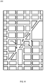
- Figure 4 illustrates another example map including traffic road strands 141a and 141b.
- the road strands may be unidirectional.
- road strand 141a is associated with a first direction (e.g., south)
- road strand 141b is associated with a second direction (e.g., north).
- Two road segments may be associated or combined into the same road strand in one direction but not in the other direction.
- the road segments may be independently grouped according to the geometry of the road segments, historical traffic data for the road segments, or attributes of the road segments. For example, in one direction B and C are grouped together in a road strand, and in the other direction A and B are grouped together in a road strand.
- Figure 5 illustrates a map for the traffic road strands of Figure 4 .
- One traffic indicator 143a is applied to road strand 141a
- another traffic indicator 143b is applied to road strand 141b.
- the traffic indicator may be shading, as illustrated by Figure 4 .
- the traffic indicators 143a and 143b may include distinguishable coloring, shading, moving icons, labeling, or other indicators. For example, green may represent no congestion, yellow may represent slowed but flowing traffic, and red may represent significantly slowed traffic.
- Figure 6A illustrates a traffic road strand 15 that corresponds to a series of road segments 133.
- the series of road segments 133 may include road segments 13a-I illustrated also in Figure 6.
- Figure 6B includes a road strand table 140.
- the road strand table 140 may be indexed by road segment or link in combination with direction.
- the road strand table 140 may include link ID paired with a direction (e.g., cardinal directions or secondary-intercardinal directions as illustrate in Figure 6B ).
- the road strand table 140 may define the sets of road segments that are grouped together in a road strand. Each road segment in a road strand may be assigned an index. Thus, in road strand table 140, road segments ID1-7 are grouped together in the same road segment and assigned road segment index values 11-17.
- the road strand table 140 may also include strand identifier (e.g., Y1). Multiple strands may be described by the same table.
- the road strand table 140 may also include any combination of speed, functional class, and jam factor, which may be used to define the road strand.
- the jam factor may define the traffic identifier (e.g., color, shading, or other indicator) that is used to describe the road strand. In one example, one range for the jam factor corresponds to one traffic indicator, another range for the jam factor corresponds to another traffic indicator, and a third range for the jam factor corresponds to a third traffic indicator.
- Figure 7A illustrates two traffic road strands 15a and 15b.
- Road strand 15a represents road segments 14a-c
- road strand 15b represents road segments 14d-g.
- Figure 7B illustrates a table 150 of traffic data for the traffic road strands of Figure 7A .
- the strands 15a-b are listed with the corresponding road segments.
- the individual road segments are associated with speeds (e.g., traffic values) that are used to select a jam factor for the strand.
- the higher speeds may be associated with a color yellow (e.g., Y)
- the lower speeds may be associated with a color red (e.g., R).
- one or more of the road segments may not be associated with any speed data.
- table 150 illustrates that road segment 14f is not associated with a speed value for the particular time epoch.
- the server 125 may identify a road segment without speed data for a current time epoch.
- the server 125 may interpolate an estimated speed value for the road segment without speed value.
- only upstream road segments may be used.
- the speed value of upstream road segments 14e and 14d may be used to calculate the estimate speed value.
- Figures 8A and 8B illustrates a pair of adjacent road segments in different traffic road strands.
- the server 125 may identify an angle ( ⁇ ) between a pair of adjacent road segments, and compare the angle to a predetermined threshold.
- a predetermined threshold e.g. 90, 125, or 150 degrees.
- the angle e.g. 90, 125, or 150 degrees.
- the angle is greater than the predetermined threshold, the pair of adjacent road segments are associated in the same road strand.
- the angle is less than the predetermined threshold, the pair of adjacent road segments are not associated in the same road strand.
- the example of Figures 8A-B is for a predetermined threshold of 125 degrees.
- road segment 161 feeds into road segment 163 at about 90 degrees. Because 90 degrees is less than the threshold, road segments 161 and 163 are not associated with the same road strand.
- a different threshold angle may be used when two road segments intersection without another road segment at the intersection. For example, when two road segments connect but there is no other option, they may be combined in the same road segment regardless of the angle between them. In another example, the two road segments may be combined in the same road segment as long as the road segment is greater than an angle (e.g., 60 degrees).
- an angle e.g. 60 degrees.
- road segment 161 feeds into road segment 163 at about 90 degrees, but no route is possible through the intersection. Thus, the road segments likely have similar traffic patterns and are combined in the same road segment.
- Figure 9A shows an intersection with a turning angle that is greater than the predetermined angle (e.g., 120 degrees) and less than a maximum angle (e.g., 180 degrees).
- the server 125 may determine that there is another continuous straight stretch of the road segment 162 with angle 180 degrees. Based on the continuation straight stretch of the road segments 162, the server 125 may split the road segment 161 and 163 into two different road strands.
- Figure 9B illustrates a road segment similar to Figure 8B except that the turning angle is greater than the predetermine angle (e.g., 120 degrees). Accordingly, the server 125 combines the two segments into a single strand.
- FIG 10 illustrates an example server 125.
- the server 125 includes a processor 300, a communication interface 305, and a memory 301.
- the server 125 may be coupled to a database 123 and a workstation 310.
- the workstation 310 may be used to enter data regarding the technique for constructing the road strands. That is, the user may input a command specifying any combination of real time traffic, historical traffic, road geometry, or routing patterns as the technique for defining the road strands.
- the database 123 may be a geographic database as discussed above. Additional, different, or fewer components may be provided in the server 125.
- Figure 6 illustrates an example flowchart for the operation of server 125. Additional, different, or fewer acts may be provided.
- the processor 300 identifies traffic data for a plurality of adjoining road segments.
- the traffic data may be speed values from mobile devices traveling on the road segments.
- the traffic data may be representative of a quantity of vehicles on the road segments, as measured by traffic sensors or traffic cameras.
- the processor 300 accesses a strand database using at least one road segment identifier and receives a strand of road segments.
- the strand of road segments is based on real time data, road attributes, road geometry or historic data. Example techniques for determining the road strand are described above.
- the processor 300 calculates an aggregate speed value for the predetermined strand of road segments based on the speed data for the plurality of adjoining road segments represented by the predetermined strand of road segments.
- the aggregate speed value may be a number representing speed (e.g., 40 miles per hour) or a speed category (e.g., free flow, light traffic, or heavy traffic).
- the aggregate speed value may be an average of the available speed values for the road segments making up the strand.
- the processor 300 may analyze real time traffic data for the road segments, and define the predetermined strand of road segments according to road segments having real time traffic data that deviates within a predetermined range.
- the processor 300 or the communication interface 305 sends the aggregate speed value as a representative of traffic on the adjoining road segments represented by the predetermined strand of road segments to another device (e.g., mobile device 122).
- the database 123a may be master geographic databases stored in a format that facilitates updating, maintenance, and development.
- a master geographic database or data in the master geographic database is in a spatial format, such as for development or production purposes.
- the spatial format or development/production database may be compiled into a delivery format such as a geographic data file (GDF) format.
- GDF geographic data file
- the data in the production and/or delivery formats may be compiled or further compiled to form geographic database products or databases that may be used in end user navigation devices or systems.
- geographic data is compiled (such as into a physical storage format (PSF) format) to organize and/or configure the data for performing navigation-related functions and/or services, such as route calculation, route guidance, map display, speed calculation, distance and travel time functions, and other functions, by a navigation device.
- the navigation-related functions may correspond to vehicle navigation, pedestrian navigation, or other types of navigation.
- the compilation to produce the end user databases may be performed by a party or entity separate from the map developer.
- a customer of the map developer such as a navigation device developer or other end user device developer, may perform compilation on a received geographic database in a delivery format to produce one or more compiled navigation databases.
- Figure 12 illustrates an exemplary mobile device 122 of the system of Figure 1 .
- the mobile device 122 includes a processor 200, a memory 204, an input device 203, a communication interface 205, position circuitry 207, and a display 211. Additional, different, or fewer components are possible for the mobile device 122.
- Figure 13 illustrates an example flowchart for the operation of the mobile device 122. Additional, different, or fewer acts may be used.
- the mobile device 122 (or navigation device 122) is configured to execute routing algorithms to determine an optimum route to travel along a road network from an origin location to a destination location in a geographic region. Using input from the end user, the navigation device 122 examines potential routes between the origin location and the destination location to determine the optimum route. The navigation device 122 may then provide the end user with information about the optimum route in the form of guidance that identifies the maneuvers required to be taken by the end user to travel from the origin to the destination location. Some navigation devices 122 show detailed maps on displays outlining the route, the types of maneuvers to be taken at various locations along the route, locations of certain types of features, and so on.
- the processor 200 or the communication interface 205 sends location data indicative of a road segment to a traffic service.
- the location data may be generated by the position circuitry 207.
- the location data may include a road segment identifier that the mobile device 122 is traveling on or near.
- the location data may include geographic coordinates for the location of the mobile device 122.
- the location data generated by the position circuitry 207 may be referenced by a local map database stored in memory 204.
- the location data referenced by the local map database may be matched to a traffic provider database.
- the traffic map database may be a different map provider or the same map provider as the local map database.
- the location data is created and referenced to the traffic provider database dynamically, which means on the fly or as needed.
- the processor 200 or the communication interface 205 receives traffic data for a road strand of a road segments including the road segment from the location data.
- the road strand may be defined by real time traffic data, historical traffic data, road geometry (e.g., internal angle), or routing data according to any of the examples describe herein.
- the processor 200 identifies an aggregate speed value for the road strand from the traffic data.
- the aggregate speed value may be a moving average of the traffic data.
- the traffic data may be filtered to determine the aggregate speed value. Outliers may be removed from the traffic data.
- the processor 200 provides, or the display 211 presents, the aggregate speed data as a representative of traffic on the plurality of adjoining road segments represented by the predetermined strand of road segments.
- the aggregate speed data may be presented as part of a mapping application.
- the workstation 128 or the mobile device 122 may present a website or another type of application that presents a map to the user. As the user scrolls the map to different geographic locations, requests are generated for the map tiles associated with the geographic locations.
- the aggregate speed data may be presented as part of a navigation application. As the mobile device 122 travels through a geographic area, requests are generated for the map tiles associated with the geographic locations.
- the aggregate speed value, or traffic data may be presented using an application programming interface (API).
- API may send location data or road segment identifiers to the server 125.
- the server 125 may access the strand database and return an aggregate speed value or traffic data for the strand.
- the positioning circuitry 207 may include a Global Positioning System (GPS), Global Navigation Satellite System (GLONASS), or a cellular or similar position sensor for providing location data.
- the positioning system may utilize GPS-type technology, a dead reckoning-type system, cellular location, or combinations of these or other systems.
- the positioning circuitry 207 may include suitable sensing devices that measure the traveling distance, speed, direction, and so on, of the mobile device 122.
- the positioning system may also include a receiver and correlation chip to obtain a GPS signal.
- the one or more detectors or sensors may include an accelerometer built or embedded into or within the interior of the mobile device 122.
- the accelerometer is operable to detect, recognize, or measure the rate of change of translational and/or rotational movement of the mobile device 122.
- the mobile device 122 receives location data from the positioning system.
- the location data indicates the location of the mobile device 122.
- the input device 203 may be one or more buttons, keypad, keyboard, mouse, stylist pen, trackball, rocker switch, touch pad, voice recognition circuit, or other device or component for inputting data to the mobile device 100.
- the input device 203 and the display 211 may be combined as a touch screen, which may be capacitive or resistive.
- the display 211 may be a liquid crystal display (LCD) panel, light emitting diode (LED) screen, thin film transistor screen, or another type of display.
- the controller 200 and/or processor 300 may include a general processor, digital signal processor, an application specific integrated circuit (ASIC), field programmable gate array (FPGA), analog circuit, digital circuit, combinations thereof, or other now known or later developed processor.
- the controller 200 and/or processor 300 may be a single device or combinations of devices, such as associated with a network, distributed processing, or cloud computing.
- the memory 204 and/or memory 301 may be a volatile memory or a non-volatile memory.
- the memory 204 and/or memory 301 may include one or more of a read only memory (ROM), random access memory (RAM), a flash memory, an electronic erasable program read only memory (EEPROM), or other type of memory.
- ROM read only memory
- RAM random access memory
- EEPROM electronic erasable program read only memory
- the memory 204 and/or memory 301 may be removable from the mobile device 122, such as a secure digital (SD) memory card.
- SD secure digital
- the communication interface 205 and/or communication interface 305 may include any operable connection.
- An operable connection may be one in which signals, physical communications, and/or logical communications may be sent and/or received.
- An operable connection may include a physical interface, an electrical interface, and/or a data interface.
- the communication interface 205 and/or communication interface 305 provides for wireless and/or wired communications in any now known or later developed format.
- the network 127 may include wired networks, wireless networks, or combinations thereof.
- the wireless network may be a cellular telephone network, an 802.11, 802.16, 802.20, or WiMax network.
- the network 127 may be a public network, such as the Internet, a private network, such as an intranet, or combinations thereof, and may utilize a variety of networking protocols now available or later developed including, but not limited to TCP/IP based networking protocols.
- computer-readable medium includes a single medium or multiple media, such as a centralized or distributed database, and/or associated caches and servers that store one or more sets of instructions.
- computer-readable medium shall also include any medium that is capable of storing, encoding or carrying a set of instructions for execution by a processor or that cause a computer system to perform any one or more of the methods or operations disclosed herein.
- the computer-readable medium can include a solid-state memory such as a memory card or other package that houses one or more non-volatile read-only memories. Further, the computer-readable medium can be a random access memory or other volatile re-writable memory. Additionally, the computer-readable medium can include a magneto-optical or optical medium, such as a disk or tapes or other storage device to capture carrier wave signals such as a signal communicated over a transmission medium. A digital file attachment to an e-mail or other self-contained information archive or set of archives may be considered a distribution medium that is a tangible storage medium.
- the disclosure is considered to include any one or more of a computer-readable medium or a distribution medium and other equivalents and successor media, in which data or instructions may be stored. These examples may be collectively referred to as a non-transitory computer readable medium.
- dedicated hardware implementations such as application specific integrated circuits, programmable logic arrays and other hardware devices, can be constructed to implement one or more of the methods described herein.
- Applications that may include the apparatus and systems of various embodiments can broadly include a variety of electronic and computer systems.
- One or more embodiments described herein may implement functions using two or more specific interconnected hardware modules or devices with related control and data signals that can be communicated between and through the modules, or as portions of an application-specific integrated circuit. Accordingly, the present system encompasses software, firmware, and hardware implementations.
- the methods described herein may be implemented by software programs executable by a computer system.
- implementations can include distributed processing, component/object distributed processing, and parallel processing.
- virtual computer system processing can be constructed to implement one or more of the methods or functionality as described herein.
- a computer program (also known as a program, software, software application, script, or code) can be written in any form of programming language, including compiled or interpreted languages, and it can be deployed in any form, including as a standalone program or as a module, component, subroutine, or other unit suitable for use in a computing environment.
- a computer program does not necessarily correspond to a file in a file system.
- a program can be stored in a portion of a file that holds other programs or data (e.g., one or more scripts stored in a markup language document), in a single file dedicated to the program in question, or in multiple coordinated files (e.g., files that store one or more modules, sub programs, or portions of code).
- a computer program can be deployed to be executed on one computer or on multiple computers that are located at one site or distributed across multiple sites and interconnected by a communication network.
- the processes and logic flows described in this specification can be performed by one or more programmable processors executing one or more computer programs to perform functions by operating on input data and generating output.
- the processes and logic flows can also be performed by, and apparatus can also be implemented as, special purpose logic circuitry, e.g., an FPGA (field programmable gate array) or an ASIC (application specific integrated circuit).
- the term 'circuitry' or 'circuit' refers to all of the following: (a)hardware-only circuit implementations (such as implementations in only analog and/or digital circuitry) and (b) to combinations of circuits and software (and/or firmware), such as (as applicable): (i) to a combination of processor(s) or (ii) to portions of processor(s)/software (including digital signal processor(s)), software, and memory(ies) that work together to cause an apparatus, such as a mobile phone or server, to perform various functions) and (c) to circuits, such as a microprocessor(s) or a portion of a microprocessor(s), that require software or firmware for operation, even if the software or firmware is not physically present.
- circuitry would also cover an implementation of merely a processor (or multiple processors) or portion of a processor and its (or their) accompanying software and/or firmware.
- circuitry would also cover, for example and if applicable to the particular claim element, a baseband integrated circuit or applications processor integrated circuit for a mobile phone or a similar integrated circuit in server, a cellular network device, or other network device.
- processors suitable for the execution of a computer program include, by way of example, both general and special purpose microprocessors, and anyone or more processors of any kind of digital computer.
- a processor receives instructions and data from a read only memory or a random access memory or both.
- the essential elements of a computer are a processor for performing instructions and one or more memory devices for storing instructions and data.
- a computer also includes, or is operatively coupled to receive data from or transfer data to, or both, one or more mass storage devices for storing data, e.g., magnetic, magneto optical disks, or optical disks.
- mass storage devices for storing data, e.g., magnetic, magneto optical disks, or optical disks.
- a computer need not have such devices.
- a computer can be embedded in another device, e.g., a mobile telephone, a personal digital assistant (PDA), a mobile audio player, a Global Positioning System (GPS) receiver, to name just a few.
- Computer readable media suitable for storing computer program instructions and data include all forms of non-volatile memory, media and memory devices, including by way of example semiconductor memory devices, e.g., EPROM, EEPROM, and flash memory devices; magnetic disks, e.g., internal hard disks or removable disks; magneto optical disks; and CD ROM and DVD-ROM disks.
- the processor and the memory can be supplemented by, or incorporated in, special purpose logic circuitry.
- embodiments of the subject matter described in this specification can be implemented on a device having a display, e.g., a CRT (cathode ray tube) or LCD (liquid crystal display) monitor, for displaying information to the user and a keyboard and a pointing device, e.g., a mouse or a trackball, by which the user can provide input to the computer.
- a display e.g., a CRT (cathode ray tube) or LCD (liquid crystal display) monitor
- a keyboard and a pointing device e.g., a mouse or a trackball
- Other kinds of devices can be used to provide for interaction with a user as well; for example, feedback provided to the user can be any form of sensory feedback, e.g., visual feedback, auditory feedback, or tactile feedback; and input from the user can be received in any form, including acoustic, speech, or tactile input.
- Embodiments of the subject matter described in this specification can be implemented in a computing system that includes a back end component, e.g., as a data server, or that includes a middleware component, e.g., an application server, or that includes a front end component, e.g., a client computer having a graphical user interface or a Web browser through which a user can interact with an implementation of the subject matter described in this specification, or any combination of one or more such back end, middleware, or front end components.
- the components of the system can be interconnected by any form or medium of digital data communication, e.g., a communication network. Examples of communication networks include a local area network (“LAN”) and a wide area network (“WAN”), e.g., the Internet.
- LAN local area network
- WAN wide area network
- the computing system can include clients and servers.
- a client and server are generally remote from each other and typically interact through a communication network.
- the relationship of client and server arises by virtue of computer programs running on the respective computers and having a client-server relationship to each other.
- inventions of the disclosure may be referred to herein, individually and/or collectively, by the term "invention" merely for convenience and without intending to voluntarily limit the scope of this application to any particular invention or inventive concept.
- inventions may be referred to herein, individually and/or collectively, by the term "invention" merely for convenience and without intending to voluntarily limit the scope of this application to any particular invention or inventive concept.
- specific embodiments have been illustrated and described herein, it should be appreciated that any subsequent arrangement designed to achieve the same or similar purpose may be substituted for the specific embodiments shown.
- This disclosure is intended to cover any and all subsequent adaptations or variations of various embodiments. Combinations of the above embodiments, and other embodiments not specifically described herein, will be apparent to those of skill in the art upon reviewing the description.
Applications Claiming Priority (1)
| Application Number | Priority Date | Filing Date | Title |
|---|---|---|---|
| US14/663,134 US9659491B2 (en) | 2015-03-19 | 2015-03-19 | Dynamic location referencing strands |
Publications (2)
| Publication Number | Publication Date |
|---|---|
| EP3073461A1 true EP3073461A1 (fr) | 2016-09-28 |
| EP3073461B1 EP3073461B1 (fr) | 2021-06-09 |
Family
ID=55628768
Family Applications (1)
| Application Number | Title | Priority Date | Filing Date |
|---|---|---|---|
| EP16160939.1A Active EP3073461B1 (fr) | 2015-03-19 | 2016-03-17 | Procede et appareil de calcul de valeurs de vitesse pour faisceaux de segments de route |
Country Status (2)
| Country | Link |
|---|---|
| US (1) | US9659491B2 (fr) |
| EP (1) | EP3073461B1 (fr) |
Cited By (1)
| Publication number | Priority date | Publication date | Assignee | Title |
|---|---|---|---|---|
| CN110415517A (zh) * | 2019-07-15 | 2019-11-05 | 中国地质大学(北京) | 一种基于车辆行驶轨迹的道路拥堵精准预警系统及方法 |
Families Citing this family (11)
| Publication number | Priority date | Publication date | Assignee | Title |
|---|---|---|---|---|
| US9945689B2 (en) * | 2015-08-25 | 2018-04-17 | Here Global B.V. | Location referencing for roadway feature data |
| CN107369318A (zh) * | 2016-05-11 | 2017-11-21 | 杭州海康威视数字技术股份有限公司 | 一种速度预测方法及装置 |
| US11293776B2 (en) * | 2018-11-27 | 2022-04-05 | Verizon Patent And Licensing Inc. | Smart geocoding of road intersections |
| US20220205801A1 (en) * | 2019-05-13 | 2022-06-30 | Nippon Telegraph And Telephone Corporation | Walk through display device, walk through display method, and walk through display program |
| KR20210006143A (ko) * | 2019-07-08 | 2021-01-18 | 현대자동차주식회사 | 교통 정보 제공 시스템 및 방법 |
| US11906309B2 (en) * | 2019-09-27 | 2024-02-20 | Here Global B.V. | Method and apparatus for providing a map matcher tolerant to wrong map features |
| US11514780B2 (en) | 2019-11-26 | 2022-11-29 | Here Global B.V. | Method, apparatus and computer program product for defining a strand upstream of a direction-based traffic link |
| DE102019220510A1 (de) * | 2019-12-23 | 2021-06-24 | Robert Bosch Gmbh | Verfahren zum Bereitstellen einer digitalen Lokalisierungskarte |
| US11756417B2 (en) * | 2020-09-16 | 2023-09-12 | Here Global B.V. | Method, apparatus, and system for detecting road incidents |
| US11804132B2 (en) * | 2021-06-10 | 2023-10-31 | Toyota Motor Engineering & Manufacturing North America, Inc. | Systems and methods for displaying bird's eye view of a roadway |
| US20230204376A1 (en) * | 2021-12-29 | 2023-06-29 | Here Global B.V. | Detecting and obtaining lane level insight in unplanned incidents |
Citations (2)
| Publication number | Priority date | Publication date | Assignee | Title |
|---|---|---|---|---|
| US20080004789A1 (en) * | 2006-06-30 | 2008-01-03 | Microsoft Corporation | Inferring road speeds for context-sensitive routing |
| US20110288756A1 (en) * | 2006-03-03 | 2011-11-24 | Inrix, Inc. | Filtering road traffic condition data obtained from mobile data sources |
Family Cites Families (14)
| Publication number | Priority date | Publication date | Assignee | Title |
|---|---|---|---|---|
| TW349211B (en) | 1996-01-12 | 1999-01-01 | Sumitomo Electric Industries | Method snd apparatus traffic jam measurement, and method and apparatus for image processing |
| US6466862B1 (en) | 1999-04-19 | 2002-10-15 | Bruce DeKock | System for providing traffic information |
| AUPQ181699A0 (en) * | 1999-07-23 | 1999-08-19 | Cmte Development Limited | A system for relative vehicle navigation |
| US7116326B2 (en) | 2002-09-06 | 2006-10-03 | Traffic.Com, Inc. | Method of displaying traffic flow data representing traffic conditions |
| KR100688018B1 (ko) * | 2005-02-16 | 2007-02-27 | 엘지전자 주식회사 | 도로 명 데이터의 표시위치 결정방법 |
| US20070155360A1 (en) * | 2005-12-30 | 2007-07-05 | Yafan An | Methods, Apparatuses and Systems for the Reporting of Roadway Speed and Incident Data and the Constructing of Speed Map Database |
| US7912628B2 (en) * | 2006-03-03 | 2011-03-22 | Inrix, Inc. | Determining road traffic conditions using data from multiple data sources |
| US7899611B2 (en) * | 2006-03-03 | 2011-03-01 | Inrix, Inc. | Detecting anomalous road traffic conditions |
| US20070208498A1 (en) * | 2006-03-03 | 2007-09-06 | Inrix, Inc. | Displaying road traffic condition information and user controls |
| GB0822893D0 (en) * | 2008-12-16 | 2009-01-21 | Tele Atlas Bv | Advanced speed profiles - Further updates |
| WO2010081836A1 (fr) * | 2009-01-16 | 2010-07-22 | Tele Atlas B.V. | Procédé pour calculer un trajet économe en énergie |
| US8384564B2 (en) | 2009-03-06 | 2013-02-26 | Navteq B.V. | Method and system for adding gadgets to a traffic report |
| US20110224891A1 (en) * | 2010-03-10 | 2011-09-15 | Nokia Corporation | Method and apparatus for aggregating traffic information using rich trip lines |
| US9014632B2 (en) | 2011-04-29 | 2015-04-21 | Here Global B.V. | Obtaining vehicle traffic information using mobile bluetooth detectors |
-
2015
- 2015-03-19 US US14/663,134 patent/US9659491B2/en active Active
-
2016
- 2016-03-17 EP EP16160939.1A patent/EP3073461B1/fr active Active
Patent Citations (2)
| Publication number | Priority date | Publication date | Assignee | Title |
|---|---|---|---|---|
| US20110288756A1 (en) * | 2006-03-03 | 2011-11-24 | Inrix, Inc. | Filtering road traffic condition data obtained from mobile data sources |
| US20080004789A1 (en) * | 2006-06-30 | 2008-01-03 | Microsoft Corporation | Inferring road speeds for context-sensitive routing |
Cited By (1)
| Publication number | Priority date | Publication date | Assignee | Title |
|---|---|---|---|---|
| CN110415517A (zh) * | 2019-07-15 | 2019-11-05 | 中国地质大学(北京) | 一种基于车辆行驶轨迹的道路拥堵精准预警系统及方法 |
Also Published As
| Publication number | Publication date |
|---|---|
| EP3073461B1 (fr) | 2021-06-09 |
| US9659491B2 (en) | 2017-05-23 |
| US20160275786A1 (en) | 2016-09-22 |
Similar Documents
| Publication | Publication Date | Title |
|---|---|---|
| EP3073461B1 (fr) | Procede et appareil de calcul de valeurs de vitesse pour faisceaux de segments de route | |
| US9489838B2 (en) | Probabilistic road system reporting | |
| US9558657B2 (en) | Lane level congestion splitting | |
| US10629069B2 (en) | Method and apparatus for providing a localized link-centric metric for directional traffic propagation | |
| US10672264B2 (en) | Predictive incident aggregation | |
| US9739621B2 (en) | Deviation detection in mobile transit systems | |
| US20160155325A1 (en) | Traffic Classification Based on Spatial Neighbor Model | |
| US9851205B2 (en) | Road segments with multi-modal traffic patterns | |
| US20200357273A1 (en) | Method, apparatus, and system for detecting venue trips and related road traffic | |
| US10054450B2 (en) | Method and apparatus for determining trajectory paths on a transportation structure | |
| US20190103019A1 (en) | Method and apparatus for identifying a transport mode of probe data | |
| US9518837B2 (en) | Monitoring and visualizing traffic surprises | |
| EP2976762A1 (fr) | Prévision d'arrivée de véhicule | |
| US10068469B2 (en) | Precision traffic indication | |
| US9689705B2 (en) | Systems and methods for electronic display of various conditions along a navigation route | |
| US11704897B2 (en) | Lane count estimation | |
| US20200202708A1 (en) | Method and apparatus for dynamic speed aggregation of probe data for high-occupancy vehicle lanes | |
| US11087616B2 (en) | Method and apparatus for recommending services based on map-based dynamic location sampling | |
| US11587433B2 (en) | Method, apparatus, and system for probe anomaly detection | |
| US20210164784A1 (en) | Method and apparatus for providing an indoor pedestrian origin-destination matrix and flow analytics | |
| Correa et al. | Urban path travel time estimation using GPS trajectories from high-sampling-rate ridesourcing services | |
| US11391586B2 (en) | Method and apparatus for discovery of semantic nodes for map-based dynamic location sampling |
Legal Events
| Date | Code | Title | Description |
|---|---|---|---|
| PUAI | Public reference made under article 153(3) epc to a published international application that has entered the european phase |
Free format text: ORIGINAL CODE: 0009012 |
|
| AK | Designated contracting states |
Kind code of ref document: A1 Designated state(s): AL AT BE BG CH CY CZ DE DK EE ES FI FR GB GR HR HU IE IS IT LI LT LU LV MC MK MT NL NO PL PT RO RS SE SI SK SM TR |
|
| AX | Request for extension of the european patent |
Extension state: BA ME |
|
| STAA | Information on the status of an ep patent application or granted ep patent |
Free format text: STATUS: REQUEST FOR EXAMINATION WAS MADE |
|
| 17P | Request for examination filed |
Effective date: 20170306 |
|
| RBV | Designated contracting states (corrected) |
Designated state(s): AL AT BE BG CH CY CZ DE DK EE ES FI FR GB GR HR HU IE IS IT LI LT LU LV MC MK MT NL NO PL PT RO RS SE SI SK SM TR |
|
| STAA | Information on the status of an ep patent application or granted ep patent |
Free format text: STATUS: EXAMINATION IS IN PROGRESS |
|
| 17Q | First examination report despatched |
Effective date: 20180719 |
|
| STAA | Information on the status of an ep patent application or granted ep patent |
Free format text: STATUS: EXAMINATION IS IN PROGRESS |
|
| GRAP | Despatch of communication of intention to grant a patent |
Free format text: ORIGINAL CODE: EPIDOSNIGR1 |
|
| STAA | Information on the status of an ep patent application or granted ep patent |
Free format text: STATUS: GRANT OF PATENT IS INTENDED |
|
| INTG | Intention to grant announced |
Effective date: 20200818 |
|
| RIN1 | Information on inventor provided before grant (corrected) |
Inventor name: FOWE, JAMES |
|
| RIN1 | Information on inventor provided before grant (corrected) |
Inventor name: FOWE, JAMES |
|
| GRAJ | Information related to disapproval of communication of intention to grant by the applicant or resumption of examination proceedings by the epo deleted |
Free format text: ORIGINAL CODE: EPIDOSDIGR1 |
|
| STAA | Information on the status of an ep patent application or granted ep patent |
Free format text: STATUS: EXAMINATION IS IN PROGRESS |
|
| GRAP | Despatch of communication of intention to grant a patent |
Free format text: ORIGINAL CODE: EPIDOSNIGR1 |
|
| STAA | Information on the status of an ep patent application or granted ep patent |
Free format text: STATUS: GRANT OF PATENT IS INTENDED |
|
| INTC | Intention to grant announced (deleted) | ||
| INTG | Intention to grant announced |
Effective date: 20210205 |
|
| GRAS | Grant fee paid |
Free format text: ORIGINAL CODE: EPIDOSNIGR3 |
|
| GRAA | (expected) grant |
Free format text: ORIGINAL CODE: 0009210 |
|
| STAA | Information on the status of an ep patent application or granted ep patent |
Free format text: STATUS: THE PATENT HAS BEEN GRANTED |
|
| AK | Designated contracting states |
Kind code of ref document: B1 Designated state(s): AL AT BE BG CH CY CZ DE DK EE ES FI FR GB GR HR HU IE IS IT LI LT LU LV MC MK MT NL NO PL PT RO RS SE SI SK SM TR |
|
| REG | Reference to a national code |
Ref country code: GB Ref legal event code: FG4D |
|
| REG | Reference to a national code |
Ref country code: CH Ref legal event code: EP Ref country code: AT Ref legal event code: REF Ref document number: 1401143 Country of ref document: AT Kind code of ref document: T Effective date: 20210615 |
|
| REG | Reference to a national code |
Ref country code: DE Ref legal event code: R096 Ref document number: 602016059037 Country of ref document: DE |
|
| REG | Reference to a national code |
Ref country code: IE Ref legal event code: FG4D |
|
| REG | Reference to a national code |
Ref country code: NL Ref legal event code: FP |
|
| REG | Reference to a national code |
Ref country code: LT Ref legal event code: MG9D |
|
| PG25 | Lapsed in a contracting state [announced via postgrant information from national office to epo] |
Ref country code: FI Free format text: LAPSE BECAUSE OF FAILURE TO SUBMIT A TRANSLATION OF THE DESCRIPTION OR TO PAY THE FEE WITHIN THE PRESCRIBED TIME-LIMIT Effective date: 20210609 Ref country code: LT Free format text: LAPSE BECAUSE OF FAILURE TO SUBMIT A TRANSLATION OF THE DESCRIPTION OR TO PAY THE FEE WITHIN THE PRESCRIBED TIME-LIMIT Effective date: 20210609 Ref country code: HR Free format text: LAPSE BECAUSE OF FAILURE TO SUBMIT A TRANSLATION OF THE DESCRIPTION OR TO PAY THE FEE WITHIN THE PRESCRIBED TIME-LIMIT Effective date: 20210609 Ref country code: BG Free format text: LAPSE BECAUSE OF FAILURE TO SUBMIT A TRANSLATION OF THE DESCRIPTION OR TO PAY THE FEE WITHIN THE PRESCRIBED TIME-LIMIT Effective date: 20210909 |
|
| REG | Reference to a national code |
Ref country code: AT Ref legal event code: MK05 Ref document number: 1401143 Country of ref document: AT Kind code of ref document: T Effective date: 20210609 |
|
| PG25 | Lapsed in a contracting state [announced via postgrant information from national office to epo] |
Ref country code: LV Free format text: LAPSE BECAUSE OF FAILURE TO SUBMIT A TRANSLATION OF THE DESCRIPTION OR TO PAY THE FEE WITHIN THE PRESCRIBED TIME-LIMIT Effective date: 20210609 Ref country code: GR Free format text: LAPSE BECAUSE OF FAILURE TO SUBMIT A TRANSLATION OF THE DESCRIPTION OR TO PAY THE FEE WITHIN THE PRESCRIBED TIME-LIMIT Effective date: 20210910 Ref country code: NO Free format text: LAPSE BECAUSE OF FAILURE TO SUBMIT A TRANSLATION OF THE DESCRIPTION OR TO PAY THE FEE WITHIN THE PRESCRIBED TIME-LIMIT Effective date: 20210909 Ref country code: RS Free format text: LAPSE BECAUSE OF FAILURE TO SUBMIT A TRANSLATION OF THE DESCRIPTION OR TO PAY THE FEE WITHIN THE PRESCRIBED TIME-LIMIT Effective date: 20210609 Ref country code: SE Free format text: LAPSE BECAUSE OF FAILURE TO SUBMIT A TRANSLATION OF THE DESCRIPTION OR TO PAY THE FEE WITHIN THE PRESCRIBED TIME-LIMIT Effective date: 20210609 |
|
| PG25 | Lapsed in a contracting state [announced via postgrant information from national office to epo] |
Ref country code: ES Free format text: LAPSE BECAUSE OF FAILURE TO SUBMIT A TRANSLATION OF THE DESCRIPTION OR TO PAY THE FEE WITHIN THE PRESCRIBED TIME-LIMIT Effective date: 20210609 Ref country code: RO Free format text: LAPSE BECAUSE OF FAILURE TO SUBMIT A TRANSLATION OF THE DESCRIPTION OR TO PAY THE FEE WITHIN THE PRESCRIBED TIME-LIMIT Effective date: 20210609 Ref country code: PT Free format text: LAPSE BECAUSE OF FAILURE TO SUBMIT A TRANSLATION OF THE DESCRIPTION OR TO PAY THE FEE WITHIN THE PRESCRIBED TIME-LIMIT Effective date: 20211011 Ref country code: AT Free format text: LAPSE BECAUSE OF FAILURE TO SUBMIT A TRANSLATION OF THE DESCRIPTION OR TO PAY THE FEE WITHIN THE PRESCRIBED TIME-LIMIT Effective date: 20210609 Ref country code: CZ Free format text: LAPSE BECAUSE OF FAILURE TO SUBMIT A TRANSLATION OF THE DESCRIPTION OR TO PAY THE FEE WITHIN THE PRESCRIBED TIME-LIMIT Effective date: 20210609 Ref country code: EE Free format text: LAPSE BECAUSE OF FAILURE TO SUBMIT A TRANSLATION OF THE DESCRIPTION OR TO PAY THE FEE WITHIN THE PRESCRIBED TIME-LIMIT Effective date: 20210609 Ref country code: SK Free format text: LAPSE BECAUSE OF FAILURE TO SUBMIT A TRANSLATION OF THE DESCRIPTION OR TO PAY THE FEE WITHIN THE PRESCRIBED TIME-LIMIT Effective date: 20210609 Ref country code: SM Free format text: LAPSE BECAUSE OF FAILURE TO SUBMIT A TRANSLATION OF THE DESCRIPTION OR TO PAY THE FEE WITHIN THE PRESCRIBED TIME-LIMIT Effective date: 20210609 |
|
| PG25 | Lapsed in a contracting state [announced via postgrant information from national office to epo] |
Ref country code: PL Free format text: LAPSE BECAUSE OF FAILURE TO SUBMIT A TRANSLATION OF THE DESCRIPTION OR TO PAY THE FEE WITHIN THE PRESCRIBED TIME-LIMIT Effective date: 20210609 |
|
| REG | Reference to a national code |
Ref country code: DE Ref legal event code: R097 Ref document number: 602016059037 Country of ref document: DE |
|
| PLBE | No opposition filed within time limit |
Free format text: ORIGINAL CODE: 0009261 |
|
| STAA | Information on the status of an ep patent application or granted ep patent |
Free format text: STATUS: NO OPPOSITION FILED WITHIN TIME LIMIT |
|
| PG25 | Lapsed in a contracting state [announced via postgrant information from national office to epo] |
Ref country code: DK Free format text: LAPSE BECAUSE OF FAILURE TO SUBMIT A TRANSLATION OF THE DESCRIPTION OR TO PAY THE FEE WITHIN THE PRESCRIBED TIME-LIMIT Effective date: 20210609 |
|
| 26N | No opposition filed |
Effective date: 20220310 |
|
| PG25 | Lapsed in a contracting state [announced via postgrant information from national office to epo] |
Ref country code: AL Free format text: LAPSE BECAUSE OF FAILURE TO SUBMIT A TRANSLATION OF THE DESCRIPTION OR TO PAY THE FEE WITHIN THE PRESCRIBED TIME-LIMIT Effective date: 20210609 |
|
| PG25 | Lapsed in a contracting state [announced via postgrant information from national office to epo] |
Ref country code: IT Free format text: LAPSE BECAUSE OF FAILURE TO SUBMIT A TRANSLATION OF THE DESCRIPTION OR TO PAY THE FEE WITHIN THE PRESCRIBED TIME-LIMIT Effective date: 20210609 |
|
| PG25 | Lapsed in a contracting state [announced via postgrant information from national office to epo] |
Ref country code: MC Free format text: LAPSE BECAUSE OF FAILURE TO SUBMIT A TRANSLATION OF THE DESCRIPTION OR TO PAY THE FEE WITHIN THE PRESCRIBED TIME-LIMIT Effective date: 20210609 |
|
| REG | Reference to a national code |
Ref country code: CH Ref legal event code: PL |
|
| REG | Reference to a national code |
Ref country code: BE Ref legal event code: MM Effective date: 20220331 |
|
| PG25 | Lapsed in a contracting state [announced via postgrant information from national office to epo] |
Ref country code: LU Free format text: LAPSE BECAUSE OF NON-PAYMENT OF DUE FEES Effective date: 20220317 Ref country code: LI Free format text: LAPSE BECAUSE OF NON-PAYMENT OF DUE FEES Effective date: 20220331 Ref country code: IE Free format text: LAPSE BECAUSE OF NON-PAYMENT OF DUE FEES Effective date: 20220317 Ref country code: CH Free format text: LAPSE BECAUSE OF NON-PAYMENT OF DUE FEES Effective date: 20220331 |
|
| PG25 | Lapsed in a contracting state [announced via postgrant information from national office to epo] |
Ref country code: BE Free format text: LAPSE BECAUSE OF NON-PAYMENT OF DUE FEES Effective date: 20220331 |
|
| PGFP | Annual fee paid to national office [announced via postgrant information from national office to epo] |
Ref country code: NL Payment date: 20230215 Year of fee payment: 8 |
|
| PGFP | Annual fee paid to national office [announced via postgrant information from national office to epo] |
Ref country code: GB Payment date: 20230126 Year of fee payment: 8 Ref country code: DE Payment date: 20230117 Year of fee payment: 8 |
|
| P01 | Opt-out of the competence of the unified patent court (upc) registered |
Effective date: 20230523 |
|
| PGFP | Annual fee paid to national office [announced via postgrant information from national office to epo] |
Ref country code: FR Payment date: 20231229 Year of fee payment: 9 |
|
| PGFP | Annual fee paid to national office [announced via postgrant information from national office to epo] |
Ref country code: NL Payment date: 20240108 Year of fee payment: 9 |
|
| PG25 | Lapsed in a contracting state [announced via postgrant information from national office to epo] |
Ref country code: HU Free format text: LAPSE BECAUSE OF FAILURE TO SUBMIT A TRANSLATION OF THE DESCRIPTION OR TO PAY THE FEE WITHIN THE PRESCRIBED TIME-LIMIT; INVALID AB INITIO Effective date: 20160317 |