EP3062572A1 - Virtual anchor point-based wireless locating method, device and terminal - Google Patents
Virtual anchor point-based wireless locating method, device and terminal Download PDFInfo
- Publication number
- EP3062572A1 EP3062572A1 EP14792321.3A EP14792321A EP3062572A1 EP 3062572 A1 EP3062572 A1 EP 3062572A1 EP 14792321 A EP14792321 A EP 14792321A EP 3062572 A1 EP3062572 A1 EP 3062572A1
- Authority
- EP
- European Patent Office
- Prior art keywords
- positioning
- path
- signal transmission
- transmission station
- anchor point
- Prior art date
- Legal status (The legal status is an assumption and is not a legal conclusion. Google has not performed a legal analysis and makes no representation as to the accuracy of the status listed.)
- Granted
Links
Images



Classifications
-
- G—PHYSICS
- G01—MEASURING; TESTING
- G01S—RADIO DIRECTION-FINDING; RADIO NAVIGATION; DETERMINING DISTANCE OR VELOCITY BY USE OF RADIO WAVES; LOCATING OR PRESENCE-DETECTING BY USE OF THE REFLECTION OR RERADIATION OF RADIO WAVES; ANALOGOUS ARRANGEMENTS USING OTHER WAVES
- G01S5/00—Position-fixing by co-ordinating two or more direction or position line determinations; Position-fixing by co-ordinating two or more distance determinations
- G01S5/02—Position-fixing by co-ordinating two or more direction or position line determinations; Position-fixing by co-ordinating two or more distance determinations using radio waves
- G01S5/0273—Position-fixing by co-ordinating two or more direction or position line determinations; Position-fixing by co-ordinating two or more distance determinations using radio waves using multipath or indirect path propagation signals in position determination
-
- G—PHYSICS
- G01—MEASURING; TESTING
- G01S—RADIO DIRECTION-FINDING; RADIO NAVIGATION; DETERMINING DISTANCE OR VELOCITY BY USE OF RADIO WAVES; LOCATING OR PRESENCE-DETECTING BY USE OF THE REFLECTION OR RERADIATION OF RADIO WAVES; ANALOGOUS ARRANGEMENTS USING OTHER WAVES
- G01S19/00—Satellite radio beacon positioning systems; Determining position, velocity or attitude using signals transmitted by such systems
- G01S19/01—Satellite radio beacon positioning systems transmitting time-stamped messages, e.g. GPS [Global Positioning System], GLONASS [Global Orbiting Navigation Satellite System] or GALILEO
- G01S19/13—Receivers
- G01S19/22—Multipath-related issues
-
- G—PHYSICS
- G01—MEASURING; TESTING
- G01S—RADIO DIRECTION-FINDING; RADIO NAVIGATION; DETERMINING DISTANCE OR VELOCITY BY USE OF RADIO WAVES; LOCATING OR PRESENCE-DETECTING BY USE OF THE REFLECTION OR RERADIATION OF RADIO WAVES; ANALOGOUS ARRANGEMENTS USING OTHER WAVES
- G01S19/00—Satellite radio beacon positioning systems; Determining position, velocity or attitude using signals transmitted by such systems
- G01S19/38—Determining a navigation solution using signals transmitted by a satellite radio beacon positioning system
- G01S19/39—Determining a navigation solution using signals transmitted by a satellite radio beacon positioning system the satellite radio beacon positioning system transmitting time-stamped messages, e.g. GPS [Global Positioning System], GLONASS [Global Orbiting Navigation Satellite System] or GALILEO
- G01S19/40—Correcting position, velocity or attitude
-
- G—PHYSICS
- G01—MEASURING; TESTING
- G01S—RADIO DIRECTION-FINDING; RADIO NAVIGATION; DETERMINING DISTANCE OR VELOCITY BY USE OF RADIO WAVES; LOCATING OR PRESENCE-DETECTING BY USE OF THE REFLECTION OR RERADIATION OF RADIO WAVES; ANALOGOUS ARRANGEMENTS USING OTHER WAVES
- G01S19/00—Satellite radio beacon positioning systems; Determining position, velocity or attitude using signals transmitted by such systems
- G01S19/38—Determining a navigation solution using signals transmitted by a satellite radio beacon positioning system
- G01S19/39—Determining a navigation solution using signals transmitted by a satellite radio beacon positioning system the satellite radio beacon positioning system transmitting time-stamped messages, e.g. GPS [Global Positioning System], GLONASS [Global Orbiting Navigation Satellite System] or GALILEO
- G01S19/42—Determining position
-
- G—PHYSICS
- G01—MEASURING; TESTING
- G01S—RADIO DIRECTION-FINDING; RADIO NAVIGATION; DETERMINING DISTANCE OR VELOCITY BY USE OF RADIO WAVES; LOCATING OR PRESENCE-DETECTING BY USE OF THE REFLECTION OR RERADIATION OF RADIO WAVES; ANALOGOUS ARRANGEMENTS USING OTHER WAVES
- G01S5/00—Position-fixing by co-ordinating two or more direction or position line determinations; Position-fixing by co-ordinating two or more distance determinations
- G01S5/02—Position-fixing by co-ordinating two or more direction or position line determinations; Position-fixing by co-ordinating two or more distance determinations using radio waves
- G01S5/0205—Details
- G01S5/0242—Determining the position of transmitters to be subsequently used in positioning
-
- G—PHYSICS
- G01—MEASURING; TESTING
- G01S—RADIO DIRECTION-FINDING; RADIO NAVIGATION; DETERMINING DISTANCE OR VELOCITY BY USE OF RADIO WAVES; LOCATING OR PRESENCE-DETECTING BY USE OF THE REFLECTION OR RERADIATION OF RADIO WAVES; ANALOGOUS ARRANGEMENTS USING OTHER WAVES
- G01S5/00—Position-fixing by co-ordinating two or more direction or position line determinations; Position-fixing by co-ordinating two or more distance determinations
- G01S5/02—Position-fixing by co-ordinating two or more direction or position line determinations; Position-fixing by co-ordinating two or more distance determinations using radio waves
- G01S5/0252—Radio frequency fingerprinting
- G01S5/02521—Radio frequency fingerprinting using a radio-map
- G01S5/02524—Creating or updating the radio-map
- G01S5/02525—Gathering the radio frequency fingerprints
- G01S5/02526—Gathering the radio frequency fingerprints using non-dedicated equipment, e.g. user equipment or crowd-sourcing
-
- H—ELECTRICITY
- H04—ELECTRIC COMMUNICATION TECHNIQUE
- H04L—TRANSMISSION OF DIGITAL INFORMATION, e.g. TELEGRAPHIC COMMUNICATION
- H04L43/00—Arrangements for monitoring or testing data switching networks
- H04L43/16—Threshold monitoring
-
- H—ELECTRICITY
- H04—ELECTRIC COMMUNICATION TECHNIQUE
- H04W—WIRELESS COMMUNICATION NETWORKS
- H04W4/00—Services specially adapted for wireless communication networks; Facilities therefor
- H04W4/02—Services making use of location information
- H04W4/025—Services making use of location information using location based information parameters
-
- G—PHYSICS
- G01—MEASURING; TESTING
- G01S—RADIO DIRECTION-FINDING; RADIO NAVIGATION; DETERMINING DISTANCE OR VELOCITY BY USE OF RADIO WAVES; LOCATING OR PRESENCE-DETECTING BY USE OF THE REFLECTION OR RERADIATION OF RADIO WAVES; ANALOGOUS ARRANGEMENTS USING OTHER WAVES
- G01S19/00—Satellite radio beacon positioning systems; Determining position, velocity or attitude using signals transmitted by such systems
- G01S19/38—Determining a navigation solution using signals transmitted by a satellite radio beacon positioning system
- G01S19/39—Determining a navigation solution using signals transmitted by a satellite radio beacon positioning system the satellite radio beacon positioning system transmitting time-stamped messages, e.g. GPS [Global Positioning System], GLONASS [Global Orbiting Navigation Satellite System] or GALILEO
- G01S19/42—Determining position
- G01S19/428—Determining position using multipath or indirect path propagation signals in position determination
-
- G—PHYSICS
- G01—MEASURING; TESTING
- G01S—RADIO DIRECTION-FINDING; RADIO NAVIGATION; DETERMINING DISTANCE OR VELOCITY BY USE OF RADIO WAVES; LOCATING OR PRESENCE-DETECTING BY USE OF THE REFLECTION OR RERADIATION OF RADIO WAVES; ANALOGOUS ARRANGEMENTS USING OTHER WAVES
- G01S19/00—Satellite radio beacon positioning systems; Determining position, velocity or attitude using signals transmitted by such systems
- G01S19/38—Determining a navigation solution using signals transmitted by a satellite radio beacon positioning system
- G01S19/39—Determining a navigation solution using signals transmitted by a satellite radio beacon positioning system the satellite radio beacon positioning system transmitting time-stamped messages, e.g. GPS [Global Positioning System], GLONASS [Global Orbiting Navigation Satellite System] or GALILEO
- G01S19/42—Determining position
- G01S19/45—Determining position by combining measurements of signals from the satellite radio beacon positioning system with a supplementary measurement
- G01S19/46—Determining position by combining measurements of signals from the satellite radio beacon positioning system with a supplementary measurement the supplementary measurement being of a radio-wave signal type
Definitions
- the present disclosure relates to the technical field of wireless communications, and in particular to a virtual anchor point-based wireless positioning method and device, and a terminal.
- Multimode positioning can utilize advantages of various positioning methods to achieve higher positioning accuracy and response speed and also cover a wider range to implement seamless and accurate positioning.
- a satellite positioning system and a mobile communication system are organically combined for mobile phone positioning.
- Advantages of large coverage area and high open space positioning accuracy of the satellite positioning system and high indoor and dense urban area positioning accuracy of a mobile communication network are fully utilized, so that a market requirement is better met.
- positioning with a satellite positioning system is implemented by finding at least four satellites, then performing distance measurement according to time of arrival, listing at least three spherical equations or hyperbolic equations according to distances and obtaining a current position for positioning in a manner of resolving the equations.
- a GPS signal is highly attenuated, so that four satellites may not be completely found, GPS positioning may not be implemented, and a positioning function is restricted.
- the embodiments of the present disclosure provide a virtual anchor point-based wireless positioning method and device, and a terminal.
- the embodiment of the present disclosure is implemented by adopting the following technical solutions.
- a virtual anchor point-based wireless positioning method is provided, which may include that:
- a method for acquiring and storing the positioning data may include, but not limited to: acquiring the positioning data through satellite positioning or acquiring the positioning data through cellular positioning of a mobile communication system.
- the positioning data may include positioning time information and position information.
- a method for performing multipath analysis and tracking on the received wireless signals transmitted by the signal transmission station is implemented as follows:
- a method for calculating and storing the propagation distance information of each path of the signal transmission station may be implemented as follows:
- real position information of the signal transmission station is acquired in advance, and a method for acquiring the real position information may include, but not limited to:
- calculating the virtual image position information of each path of the signal transmission station according to the positioning data and the propagation distance information of each path of the signal transmission station may include that:
- bases for selecting the at least one virtual image from the virtual images of the multiple paths of the signal transmission station as the at least one positioning virtual anchor point may be that:
- the at least one positioning virtual anchor point when the current position information is obtained according to the effective positioning condition and the at least one positioning virtual anchor point, the at least one positioning virtual anchor point may be at least one selected positioning virtual anchor point of which signal strength exceeds a fourth preset threshold.
- a virtual anchor point-based wireless positioning device which may include:
- a method for the position calculation module to acquire and store the positioning data may include, but not limited to: acquiring the positioning data through satellite positioning or acquiring the positioning data through cellular positioning of a mobile communication system.
- the positioning data may include positioning time information and position information.
- the multipath separation and tracking module may include:
- the multipath distance measurement module may include:
- the multipath distance measurement module may further include:
- the virtual anchor point processing module may include:
- bases for the virtual anchor point selection module to select the at least one virtual image from the virtual images of the multiple paths of the signal transmission station as the at least one positioning virtual anchor point may be that:
- the at least one positioning virtual anchor point may be at least one selected positioning virtual anchor point of which signal strength exceeds a fourth preset threshold.
- a terminal which may include the abovementioned virtual anchor point-based wireless positioning device, the virtual anchor point-based wireless positioning device including:
- the virtual anchor point-based wireless positioning method and device, and the terminal provided by the present disclosure compared with a related art, at least have the following beneficial effects.
- multiple positioning methods are integrated, and in a rich multipath scenario (for example, an indoor environment and a dense urban area), continuously recorded virtual anchor points of multiple paths of a practical wireless signal transmission station are combined with another effective positioning condition for positioning, so that multipath information is fully utilized, positioning errors caused by signal reflection and diffraction are reduced, and in addition, the problem of insufficient effective positioning anchor points is solved.
- a rich multipath scenario for example, an indoor environment and a dense urban area
- a core idea of the technical solution provided in the embodiments of the present disclosure is to implement wireless positioning in a complex wireless multipath environment such as an indoor environment and a dense urban area through virtual anchor points on the basis of multipath tracking and identification.
- a virtual anchor point of a real anchor point refers to a position of a virtual signal transmission source after a receiver supposes that a signal is linearly transmitted and is not diffracted and reflected after the signal transmitted by the real anchor point is received by the receiver.
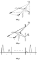
- Fig. 3 shows a schematic diagram of a practical virtual image during reflection propagation of an electromagnetic wave, and as shown in Fig.
- a wireless signal transmitted by a signal transmission source S reaches terminal 1 or 2 after being reflected by a reflector, and if a reflecting surface of the reflector does not change, a position S' of a virtual image of the signal transmission source S (anchor point) relative to terminal 1 or 2 is kept unchanged.
- a positioning method in the related art uses a real anchor point position coordinate and solves a distance equation to obtain a position of terminal 1 or 2, and the inventor of the present disclosure discovers that a positioning result obtained by such a method in the related art may have a great error under the condition that the signal is reflected greatly.
- a terminal may also be positioned according to a virtual image if a diffraction point is far away from the terminal to be positioned under the condition of existence of diffraction.
- a signal of a base station is sequentially diffracted and reflected to reach the terminal, a position, calculated by the terminal, of a virtual image may be automatically regulated to be farer, and in case of a long distance, a change in the virtual image is observed to be small when the mobile terminal moves.
- the signal is reflected for many times, and the position of the virtual image may not change along with movement of the terminal to be positioned. Referring to Fig.
- a received signal is an envelope in a time domain, and time differences among signal envelopes are caused by different propagation path distances.
- a position of a terminal is calculated and determined by virtue of a position of a virtual image of an anchor point, so as to reduce the problem of positioning error caused by multipath reflection.
- an embodiment of the present disclosure provides a virtual anchor point-based wireless positioning method, which includes:
- a method for a signal receiving station such as User Equipment (UE), the UE may be in a moving or still state
- UE User Equipment
- Step S10 when the effective positioning condition is met, acquiring and storing the positioning data includes, acquiring the positioning data through satellite positioning or acquiring the positioning data through cellular positioning of a mobile communication system.
- the positioning data may include positioning time information and position information.
- Step S10 a method for performing multipath analysis and tracking on the received wireless signals transmitted by the signal transmission station is implemented as follows:
- Step S10 after multipath analysis and tracking is performed on the received wireless signals transmitted by the signal transmission station, a method for calculating and storing the propagation distance information of each path of the signal transmission station is implemented as follows:
- Step S10 when the virtual image position information of each path of the signal transmission station is calculated according to the positioning data and the propagation distance information of each path of the signal transmission station, real position information of the signal transmission station may be acquired in advance, wherein a method for acquiring the real position information of the signal transmission station may include, but not limited to:
- a method for the signal transmission station to acquire the real position information by at least one method is implemented as follows:
- a method for calculating the virtual image position information of each path of the signal transmission station according to the positioning data and the propagation distance information of each path of the signal transmission station includes:
- Step S20 for example, whether the current effective positioning condition is met or not may be judged in a manner as follows:
- bases for selecting the at least one virtual image from the virtual images of the multiple paths of the signal transmission station as the at least one positioning virtual anchor point are that:
- the at least one positioning virtual anchor point may be at least one selected positioning virtual anchor point of which signal strength exceeds a fourth preset threshold.
- the UE can simultaneously receive signals of 2 paths of base station Bs1, i.e., the UE can receive a signal of direct transmission path P11 of base station Bs1 and a signal of P12 reflected by a surface.
- the UE can simultaneously receive signals of 2 paths of base station Bs2, i.e., the UE can receive a signal of direct transmission path P21 of base station Bs2 and a signal of P22 reflected by the surface.
- the number of the found satellites is gradually reduced along with movement, and only the satellite signal of G2 can be found at S2; and along with movement, the signal of P11 of Bs1 is also gradually weakened and the signal of P21 of Bs2 is also gradually weakened because of lack of direct transmission condition.
- the UE When reaching S2, the UE can only find the signal of G2, the signal of P12 of Bs1 and the signal of P22 of Bs2.
- the UE can be positioned through the satellite, and a positioning coordinate of UE1 is continuously recorded.
- the UE Since the UE can simultaneously receive the signals of the two paths of Bs1, the UE continuously measures and records propagation distances of the signals of the two paths.
- a position and a distance are extracted from the latest position records and path propagation distance records of the UE, a spherical equation is listed and solved to obtain and continuously record a position of a virtual image Bs1', propagated through P12, of Bs1, and since a reflecting surface changes a little, the position of Bs1' changes a little in a movement process of the UE in the embodiment.
- the UE Since the UE can simultaneously receive the signals of the two paths of Bs2, the UE continuously measures and records propagation distances of the signals of the two paths.
- a position and a distance are extracted from the latest position records and path propagation distance records of the UE, a spherical equation is listed and solved to obtain and continuously record a position of a virtual image Bs2', propagated through P22, of Bs2, and since a reflecting surface changes a little, the position of Bs2' changes a little in a movement process of the UE in the embodiment
- the UE can receive only one satellite, so that virtual images Bs1' and Bs2' are selected as virtual anchor points.
- a coordinate of the UE is set to be (x, y, z).
- UE1 can simultaneously receive signals of 2 paths of base station Bs1, i.e., the UE can receive a signal of direct transmission path P11 of base station Bs1 and a signal of P12 reflected by a surface.
- UE1 When reaching S2, UE1 can only find the signal of G2 and the signal of P12 of Bs1.
- UE1 can be positioned through the satellite outdoors, and a positioning coordinate of UE1 is continuously recorded.
- UE1 Since UE1 can simultaneously receive the signals of the two paths of Bs1, UE1 continuously measures and records propagation distances of the signals of the two paths.
- a position and a distance are extracted from the latest position records and path propagation distance records of UE1, a spherical equation is listed and solved to obtain and continuously record a position of a virtual image Bs1', propagated through P12, of Bs1, and since a reflecting surface changes a little, the position of Bs1' changes a little in a movement process of UE1 in the embodiment.
- UE1 When UE1 moves to S2, UE1 can only receive one satellite and path P12, so that virtual image Bs1' is selected as a virtual anchor point.
- a coordinate of UE1 may be set to be (x, y) in a horizontal plane inside the room.
- the UE can simultaneously receive signals of 2 paths of base station Bs1, i.e., the UE can receive a signal of P12, reflected by a surface, of Bs1.
- the number of the found satellites is gradually reduced along with movement, and the satellite signal of G4 may not be found at S2; and the signal of P12 of Bs1 can be found all the time in a movement process.
- the UE may find the signals of GPS1, GPS2 and GPS3 and the signal of P12 of Bs1.
- the UE can be positioned through the satellites, and a positioning coordinate of the UE is continuously recorded.
- the UE Since the UE can simultaneously receive the signal of P12 of Bs1, the UE continuously measures and records propagation distances of the signal.
- a position and a distance are extracted from the latest position records and path propagation distance records of the UE, a spherical equation is listed and solved to obtain and continuously record a position of a virtual image Bs1', propagated through P12, of Bs1, and since a reflecting surface changes a little, the position of Bs1' changes a little in a movement process of the UE in the embodiment.
- the UE can only receive the signals of one satellite and P12, so that virtual image Bs1' is selected as a virtual anchor point.
- the coordinate of the UE may be set to be (x, y) in a horizontal plane in the current environment.
- an embodiment of the present disclosure further provides a virtual anchor point-based wireless positioning device 10, which includes:
- a method for the position calculation module 105 to acquire and store the positioning data includes, but not limited to: acquiring the positioning data through satellite positioning or acquiring the positioning data through cellular positioning of a mobile communication system.
- the positioning data includes positioning time information and position information.
- the multipath separation and tracking module 101 includes:
- the multipath distance measurement module 102 includes:
- the multipath distance measurement module further includes:
- the virtual anchor point processing module 103 includes:
- bases for the virtual anchor point selection module 104 to select the virtual image from the virtual images of the multiple paths of the signal transmission station 20 as the positioning virtual anchor point are that:
- the at least one positioning virtual anchor point is at least one selected positioning virtual anchor point of which signal strength exceeds a fourth preset threshold.
- An embodiment of the present disclosure further correspondingly provides a terminal, which includes the abovementioned virtual anchor point-based wireless positioning device 10, still referring to Fig. 10 , the virtual anchor point-based wireless positioning device 10 including:
- the technical solutions provided by the embodiments of the present disclosure may be applied to a virtual anchor point-based wireless positioning process.
- multiple positioning methods are integrated, and in a rich multipath scenario (for example, an indoor environment and a dense urban area), continuously recorded virtual anchor points of multiple paths of a practical wireless signal transmission station are combined with another effective positioning condition for positioning, so that multipath information is fully utilized, positioning errors caused by signal reflection and diffraction are reduced, and in addition, the problem of insufficient effective positioning anchor points is solved.
Landscapes
- Engineering & Computer Science (AREA)
- Radar, Positioning & Navigation (AREA)
- Remote Sensing (AREA)
- Physics & Mathematics (AREA)
- General Physics & Mathematics (AREA)
- Computer Networks & Wireless Communication (AREA)
- Signal Processing (AREA)
- Position Fixing By Use Of Radio Waves (AREA)
- Navigation (AREA)
Abstract
Description
- The present disclosure relates to the technical field of wireless communications, and in particular to a virtual anchor point-based wireless positioning method and device, and a terminal.
- With the development of the times, the mobile phone positioning technology has drawn more and more attentions. However, all of the currently used positioning technologies, such as a Global Positioning System (GPS) positioning technology, a wireless sensor network-based positioning technology, or other positioning means, have their respective limits. In order to achieve higher positioning accuracy, combination of multiple positioning systems for cooperative positioning (also called multimode positioning) is a direction for future development. Multimode positioning can utilize advantages of various positioning methods to achieve higher positioning accuracy and response speed and also cover a wider range to implement seamless and accurate positioning.
- For example, a satellite positioning system and a mobile communication system are organically combined for mobile phone positioning. Advantages of large coverage area and high open space positioning accuracy of the satellite positioning system and high indoor and dense urban area positioning accuracy of a mobile communication network are fully utilized, so that a market requirement is better met.
- It is known that, as shown in
Fig. 1 and Fig. 2 , positioning with a satellite positioning system is implemented by finding at least four satellites, then performing distance measurement according to time of arrival, listing at least three spherical equations or hyperbolic equations according to distances and obtaining a current position for positioning in a manner of resolving the equations. - However, in an indoor circumstance or a dense urban area, a GPS signal is highly attenuated, so that four satellites may not be completely found, GPS positioning may not be implemented, and a positioning function is restricted.
- Usually, a coverage environment of a cellular network in a dense urban area and an indoor condition is obviously superior to a satellite signal, but the problem of inaccuracy of cellular positioning exists because of factors of Non Line Of Sight (NLOS), multiple paths and the like. Regarding this problem, researchers in this field have obtained some research results, but these research results are obtained on the basis of ideal assumptions, and are industrially infeasible in terms of accurate positioning. Therefore, a feasible wireless positioning method capable of providing an accurate positioning capability during a practical application is urgent to be further deeply researched and provided.
- In order to provide a feasible wireless positioning method capable of providing an accurate positioning capability during a practical application, the embodiments of the present disclosure provide a virtual anchor point-based wireless positioning method and device, and a terminal.
- In order to achieve the purpose of the embodiments of the present disclosure, the embodiment of the present disclosure is implemented by adopting the following technical solutions.
- A virtual anchor point-based wireless positioning method is provided, which may include that:
- when an effective positioning condition is met, positioning data is acquired and stored, multipath analysis and tracking is simultaneously performed on received wireless signals transmitted by a signal transmission station, propagation distance information of each path of the signal transmission station is calculated and stored, and virtual image position information of each path of the signal transmission station is calculated and stored according to the positioning data and the propagation distance information of each path of the signal transmission station; and
- when the effective positioning condition is not met, at least one virtual image is selected from virtual images of multiple paths of the signal transmission station as at least one positioning virtual anchor point, and current position information is obtained according to the effective positioning condition and the at least one positioning virtual anchor point.
- In an example embodiment, when the effective positioning condition is met, a method for acquiring and storing the positioning data may include, but not limited to: acquiring the positioning data through satellite positioning or acquiring the positioning data through cellular positioning of a mobile communication system.
- In an example embodiment, the positioning data may include positioning time information and position information.
- In an example embodiment, a method for performing multipath analysis and tracking on the received wireless signals transmitted by the signal transmission station is implemented as follows:
- the received multipath signals are separated by a signal analysis technology, the multipath signals are continuously tracked in a time domain, and if an existence time length of a single path is lower than a preset time length threshold and/or signal strength of the single path is lower than a preset signal strength threshold, tracking of the single path is stopped.
- In an example embodiment, after multipath analysis and tracking is performed on the received wireless signals transmitted by the signal transmission station, a method for calculating and storing the propagation distance information of each path of the signal transmission station may be implemented as follows:
- a signal propagation time length of each path is acquired; and
- a path propagation distance is obtained according to the signal propagation time length and a physical light speed constant, and the obtained path propagation distance, a path serial number of a corresponding path and time information are continuously stored as the propagation distance information of each path of the signal transmission station.
- In an example embodiment, when the virtual image position information of each path of the signal transmission station is calculated according to the positioning data and the propagation distance information of each path of the signal transmission station, real position information of the signal transmission station is acquired in advance, and a method for acquiring the real position information may include, but not limited to:
- acquiring the real position information of the signal transmission station from the signal transmission station through signaling, wherein the signal transmission station may acquire and store the real position information by at least one positioning method;
- or, locally and directly acquiring pre-stored real position information, measured by an engineering reconnaissance method, of the signal transmission station.
- In an example embodiment, calculating the virtual image position information of each path of the signal transmission station according to the positioning data and the propagation distance information of each path of the signal transmission station may include that:
- at least three pieces of positioning data of which effective position differences are greater than a first preset threshold are selected from storage records of the positioning data;
- the corresponding path propagation distance information is extracted from storage records of the path propagation distances according to time indexes of the positioning data; and
- a virtual image position of each path of the signal transmission station is calculated according to the positioning data and the path propagation distances.
- In an example embodiment, when the effective positioning condition is not met, bases for selecting the at least one virtual image from the virtual images of the multiple paths of the signal transmission station as the at least one positioning virtual anchor point may be that:
- a path signal strength of the corresponding path exceeds a second preset threshold; and
- last few continuous virtual image position changes of each path of the signal transmission station are smaller than a third preset threshold.
- In an example embodiment, when the current position information is obtained according to the effective positioning condition and the at least one positioning virtual anchor point, the at least one positioning virtual anchor point may be at least one selected positioning virtual anchor point of which signal strength exceeds a fourth preset threshold.
- A virtual anchor point-based wireless positioning device is provided, which may include:
- a multipath separation and tracking module, configured to perform multipath analysis and tracking on received wireless signals transmitted by a signal transmission station;
- a multipath distance measurement module, configured to calculate and store propagation distance information of each path of the signal transmission station;
- a virtual anchor point processing module, configured to calculate and store virtual image position information of each path of the signal transmission station according to positioning data and the propagation distance information of each path of the signal transmission station;
- a virtual anchor point selection module, configured to, when an effective positioning condition is not met, select at least one virtual image from virtual images of multiple paths of the signal transmission station as at least one positioning virtual anchor point; and
- a position calculation module, configured to, when the effective positioning condition is met, acquire and store the positioning data and further configured to, when the effective positioning condition is not met, obtain current position information according to the effective positioning condition and the at least one positioning virtual anchor point.
- In an example embodiment, when the effective positioning condition is met, a method for the position calculation module to acquire and store the positioning data may include, but not limited to: acquiring the positioning data through satellite positioning or acquiring the positioning data through cellular positioning of a mobile communication system.
- In an example embodiment, the positioning data may include positioning time information and position information.
- In an example embodiment, the multipath separation and tracking module may include:
- a separation and tracking processing module, configured to separate received multipath signals by a signal analysis technology, and continuously track, in a time domain, the multipath signals; and
- a multipath rejection module, configured to, if an existence time length of a single path is lower than a preset time length threshold and/or signal strength of the single path is lower than a preset signal strength threshold, send a command of stopping tracking of the corresponding path to the separation and tracking processing module.
- In an example embodiment, the multipath distance measurement module may include:
- an acquisition module, configured to acquire a signal propagation time length of each path;
- a calculation module, configured to obtain a path propagation distance according to the signal propagation time length and a physical light speed constant; and
- a storage module, configured to continuously store the obtained path propagation distance, a path serial number of a corresponding path and time information as the propagation distance information of each path of the signal transmission station.
- In an example embodiment, the multipath distance measurement module may further include:
- a first acquisition module, configured to acquire real position information of the signal transmission station from the signal transmission station, wherein the signal transmission station may acquire and store the real position information by at least one positioning method or store real position information measured by an engineering reconnaissance method;
- or, a second acquisition module, configured to locally and directly acquire the pre-stored real position information, measured by the engineering reconnaissance method, of the signal transmission station.
- In an example embodiment, the virtual anchor point processing module may include:
- a selection module, configured to select, from storage records of the positioning data, at least three pieces of positioning data of which effective position differences are greater than a first preset threshold;
- an extraction module, configured to extract the corresponding path propagation distance information from storage records of the path propagation distances according to time indexes of the positioning data; and
- a processing module, configured to calculate a virtual image position of each path of the signal transmission station according to the positioning data and the path propagation distances.
- In an example embodiment, when the effective positioning condition is not met, bases for the virtual anchor point selection module to select the at least one virtual image from the virtual images of the multiple paths of the signal transmission station as the at least one positioning virtual anchor point may be that:
- a path signal strength of the corresponding path exceeds a second preset threshold; and
- last few continuous virtual image position changes of each path of the signal transmission station are smaller than a third preset threshold.
- In an example embodiment, when the position calculation module obtains the current position information according to the effective positioning condition and the at least one positioning virtual anchor point, the at least one positioning virtual anchor point may be at least one selected positioning virtual anchor point of which signal strength exceeds a fourth preset threshold.
- A terminal is provided, which may include the abovementioned virtual anchor point-based wireless positioning device, the virtual anchor point-based wireless positioning device including:
- a multipath separation and tracking module, configured to perform multipath analysis and tracking on received wireless signals transmitted by a signal transmission station;
- a multipath distance measurement module, configured to calculate and store propagation distance information of each path of the signal transmission station;
- a virtual anchor point processing module, configured to calculate and store virtual image position information of each path of the signal transmission station according to positioning data and the propagation distance information of each path of the signal transmission station;
- a virtual anchor point selection module, configured to, when an effective positioning condition is not met, select at least one virtual image from virtual images of multiple paths of the signal transmission station as at least one positioning virtual anchor point; and
- a position calculation module, configured to, when the effective positioning condition is met, acquire and store the positioning data and further configured to, when the effective positioning condition is not met, obtain current position information according to the effective positioning condition and the at least one positioning virtual anchor point.
- From the technical solutions of the embodiments of the present disclosure, the virtual anchor point-based wireless positioning method and device, and the terminal provided by the present disclosure, compared with a related art, at least have the following beneficial effects.
- According to the embodiments of the disclosure, multiple positioning methods are integrated, and in a rich multipath scenario (for example, an indoor environment and a dense urban area), continuously recorded virtual anchor points of multiple paths of a practical wireless signal transmission station are combined with another effective positioning condition for positioning, so that multipath information is fully utilized, positioning errors caused by signal reflection and diffraction are reduced, and in addition, the problem of insufficient effective positioning anchor points is solved.
-
-
Fig. 1 is a diagram of positioning with a spherical equation in the related art; -
Fig. 2 is a diagram of positioning with a hyperbolic equation in the related art; -
Fig. 3 is a schematic diagram of a practical virtual image during reflection propagation of an electromagnetic wave; -
Fig. 4 is a schematic diagram of a practical virtual image during sequential diffraction and reflection propagation of an electromagnetic wave; -
Fig. 5 is a diagram of multipath separation; -
Fig. 6 is a flowchart of a virtual anchor point-based wireless positioning method according to an embodiment of the present disclosure; -
Fig. 7 is a diagram of virtual anchor point-based wireless positioning in a mine environment according toembodiment 1 of the present disclosure; -
Fig. 8 is a diagram of virtual anchor point-based wireless positioning in an indoor environment according toembodiment 2 of the present disclosure; -
Fig. 9 is a diagram of virtual anchor point-based wireless positioning in a dense urban area environment according to embodiment 3 of the present disclosure; -
Fig. 10 is a structure diagram of a virtual anchor point-based wireless positioning device according to an embodiment of the present disclosure; -
Fig. 11 is a function structure diagram of a multipath separation and tracking module according to an embodiment of the present disclosure; -
Fig. 12 is a function structure diagram of a multipath distance measurement module according to an embodiment of the present disclosure; and -
Fig. 13 is a function structure diagram of a virtual anchor point processing module according to an embodiment of the present disclosure. - Achievement of the purpose, function characteristics and good effects of the present disclosure will be further described below with reference to specific embodiments and the drawings.
- The technical solutions of the present disclosure will be further described below with reference to the drawings and specific embodiments in detail to make those skilled in the art better understand and implement the present disclosure, but the enumerated embodiments are not intended to limit the present disclosure.
- A core idea of the technical solution provided in the embodiments of the present disclosure is to implement wireless positioning in a complex wireless multipath environment such as an indoor environment and a dense urban area through virtual anchor points on the basis of multipath tracking and identification. A virtual anchor point of a real anchor point refers to a position of a virtual signal transmission source after a receiver supposes that a signal is linearly transmitted and is not diffracted and reflected after the signal transmitted by the real anchor point is received by the receiver.
Fig. 3 shows a schematic diagram of a practical virtual image during reflection propagation of an electromagnetic wave, and as shown inFig. 4 , a wireless signal transmitted by a signal transmission source S reaches terminal 1 or 2 after being reflected by a reflector, and if a reflecting surface of the reflector does not change, a position S' of a virtual image of the signal transmission source S (anchor point) relative toterminal terminal - In addition, according to the embodiments of the present disclosure, a terminal may also be positioned according to a virtual image if a diffraction point is far away from the terminal to be positioned under the condition of existence of diffraction. As shown in
Fig. 5 , a signal of a base station is sequentially diffracted and reflected to reach the terminal, a position, calculated by the terminal, of a virtual image may be automatically regulated to be farer, and in case of a long distance, a change in the virtual image is observed to be small when the mobile terminal moves. Moreover, the signal is reflected for many times, and the position of the virtual image may not change along with movement of the terminal to be positioned. Referring toFig. 5 , under the condition of multiple propagation paths, a received signal is an envelope in a time domain, and time differences among signal envelopes are caused by different propagation path distances. According to the embodiments of the present disclosure, a position of a terminal is calculated and determined by virtue of a position of a virtual image of an anchor point, so as to reduce the problem of positioning error caused by multipath reflection. - Referring to
Fig. 6 , an embodiment of the present disclosure provides a virtual anchor point-based wireless positioning method, which includes: - Step S10: when an effective positioning condition is met, positioning data is acquired and stored, multipath analysis and tracking is simultaneously performed on received wireless signals transmitted by a signal transmission station, propagation distance information of each path of the signal transmission station is calculated and stored, and virtual image position information of each path of the signal transmission station is calculated and stored according to the positioning data and the propagation distance information of each path of the signal transmission station; and
- Step S20: when the effective positioning condition is not met, at least one virtual image is selected from virtual images of multiple paths of the signal transmission station as at least one positioning virtual anchor point, and current position information is obtained according to the effective positioning condition and the at least one positioning virtual anchor point.
- For example, in the embodiment of the present disclosure, for Step S10, a method for a signal receiving station (such as User Equipment (UE), the UE may be in a moving or still state) to acquire the positioning data may be implemented as follows:
- if the signal receiving station can find sufficient satellites, a position calculation method the same as that of the signal transmission station is used, and if the signal receiving station uses integration information of satellite and virtual anchor point, then:
- suppose that a space coordinate of the signal receiving station is (α,x,y,z), a spherical equation set is listed according to distances away from the satellites and distances away from virtual anchor points, and the coordinate of the signal receiving station is solved; and
- if satellite anchor points are not included, the coordinate of the signal receiving station is set to be (x, y, z), a spherical equation set is listed according to the distances away from the virtual anchor points, and the coordinate of the signal receiving station is solved.
- In the embodiment, for Step S10, when the effective positioning condition is met, acquiring and storing the positioning data includes, acquiring the positioning data through satellite positioning or acquiring the positioning data through cellular positioning of a mobile communication system.
- In an example embodiment, the positioning data may include positioning time information and position information.
- For Step S10, a method for performing multipath analysis and tracking on the received wireless signals transmitted by the signal transmission station is implemented as follows:
- the received multipath signals are separated by a signal analysis technology, the multipath signals are continuously tracked in a time domain, and if an existence time length of a single path is lower than a preset time length threshold and/or signal strength of the single path is lower than a preset signal strength threshold, tracking of the single path is stopped.
- For Step S10, after multipath analysis and tracking is performed on the received wireless signals transmitted by the signal transmission station, a method for calculating and storing the propagation distance information of each path of the signal transmission station is implemented as follows:
- Step S101: a signal propagation time length of each path is acquired; and
- Step S102: a path propagation distance is obtained according to the signal propagation time length and a physical light speed constant, and the obtained path propagation distance, a path serial number of a corresponding path and time information are continuously stored as the propagation distance information of each path of the signal transmission station.
- For Step S10, when the virtual image position information of each path of the signal transmission station is calculated according to the positioning data and the propagation distance information of each path of the signal transmission station, real position information of the signal transmission station may be acquired in advance, wherein a method for acquiring the real position information of the signal transmission station may include, but not limited to:
- 1: acquiring the real position information of the signal transmission station from the signal transmission station through signaling, wherein the signal transmission station acquires and stores the real position information by at least one positioning method or stores the real position information measured by an engineering reconnaissance method;
- 2: or, locally and directly acquiring pre-stored real position information, measured by the engineering reconnaissance method, of the signal transmission station.
- In the embodiment of the present disclosure, a method for the signal transmission station to acquire the real position information by at least one method is implemented as follows:
- the space coordinate of the signal transmission station is set to be (α, x, y, z), wherein α represents a timing difference between the signal transmission station and the satellite, and x, y and z represent the space coordinate of the signal transmission station; the signal transmission station may find at least 4 GPS satellites and measure distances di between the signal transmission station and the at least 4 satellites. An equation set is listed according to spherical equations, and the coordinate of the signal transmission station is solved; or subtraction is performed on the distances between the signal transmission station and the two satellites, a hyperbolic equation set is listed, and the coordinate of the signal transmission station is solved.
- For Step S10, a method for calculating the virtual image position information of each path of the signal transmission station according to the positioning data and the propagation distance information of each path of the signal transmission station includes:
- Step S103: at least three pieces of positioning data of which effective position differences are greater than a first preset threshold are selected from storage records of the positioning data;
- Step S104: the corresponding path propagation distance information is extracted from storage records of the path propagation distances according to time indexes of the positioning data; and
- Step S105: a virtual image position of each path of the signal transmission station is calculated according to the positioning data and the path propagation distances.
- In Step S20, for example, whether the current effective positioning condition is met or not may be judged in a manner as follows:
- 1: if the number of the found satellites is more than or equal to 4, a positioning anchor point set only includes the satellites; and
- 2: or, if the number of the found satellites is smaller than 4, the positioning anchor point set includes the found satellites and at least one selected virtual anchor point, wherein the sum of the number of the satellites and the number of the at least one virtual anchor point is more than or equal to 4.
- For Step S20, when the effective positioning condition is not met, bases for selecting the at least one virtual image from the virtual images of the multiple paths of the signal transmission station as the at least one positioning virtual anchor point are that:
- first, a path signal strength of the corresponding path exceeds a second preset threshold; and
- second, last few continuous virtual image position changes of each path of the signal transmission station are smaller than a third preset threshold.
- For Step S20, when the current position information is obtained according to the effective positioning condition and the at least one positioning virtual anchor point, the at least one positioning virtual anchor point may be at least one selected positioning virtual anchor point of which signal strength exceeds a fourth preset threshold.
- In order to better describe the principle of the embodiments of the present disclosure, specific embodiments about application of the technical solution provided by the embodiments of the present disclosure to a mine, an indoor environment and a dense urban area will be enumerated.
- As shown in
Fig. 7 , in the mine, one piece of UE moves from position S1 to S2, and it is supposed that there are 4 satellites in the sky. - According to a satellite navigation positioning algorithm in the related art, at least 4 satellite signals are required to be received for positioning. In the embodiment: when the UE is at position S1:
- the UE can receive signals of totally 4 satellites GPS1, GPS2, GPS3 and GPS4, and meets an independent positioning condition, and positioning information is set to be (α, x1, y1, z1), wherein α is a time difference of a clock of the signal receiving station and the satellites, and x1, y1 and z1 are three-dimensional coordinates respectively.
- The UE can simultaneously receive signals of 2 paths of base station Bs1, i.e., the UE can receive a signal of direct transmission path P11 of base station Bs1 and a signal of P12 reflected by a surface.
- The UE can simultaneously receive signals of 2 paths of base station Bs2, i.e., the UE can receive a signal of direct transmission path P21 of base station Bs2 and a signal of P22 reflected by the surface.
- When the UE moves from position S1 to position S2, namely gradually moves from a wellhead to a deep part of a well, the number of the found satellites is gradually reduced along with movement, and only the satellite signal of G2 can be found at S2; and along with movement, the signal of P11 of Bs1 is also gradually weakened and the signal of P21 of Bs2 is also gradually weakened because of lack of direct transmission condition.
- When reaching S2, the UE can only find the signal of G2, the signal of P12 of Bs1 and the signal of P22 of Bs2.
- At the wellhead, the UE can be positioned through the satellite, and a positioning coordinate of UE1 is continuously recorded.
- Since the UE can simultaneously receive the signals of the two paths of Bs1, the UE continuously measures and records propagation distances of the signals of the two paths.
- A position and a distance are extracted from the latest position records and path propagation distance records of the UE, a spherical equation is listed and solved to obtain and continuously record a position of a virtual image Bs1', propagated through P12, of Bs1, and since a reflecting surface changes a little, the position of Bs1' changes a little in a movement process of the UE in the embodiment.
- Since the UE can simultaneously receive the signals of the two paths of Bs2, the UE continuously measures and records propagation distances of the signals of the two paths.
- A position and a distance are extracted from the latest position records and path propagation distance records of the UE, a spherical equation is listed and solved to obtain and continuously record a position of a virtual image Bs2', propagated through P22, of Bs2, and since a reflecting surface changes a little, the position of Bs2' changes a little in a movement process of the UE in the embodiment
- When the UE moves to S2, the UE can receive only one satellite, so that virtual images Bs1' and Bs2' are selected as virtual anchor points.
- A coordinate of the UE is set to be (x, y, z).
- According to positions and distances between UE1 and three anchor points G2, Bs1' and Bs2', a distance equation is listed, and the coordinate of the UE is solved.
- As shown in
Fig. 8 , in an indoor environment, one piece of UE1 moves from position S1 to S2, and it is supposed that there are 4 satellites in the sky. - According to a satellite navigation positioning algorithm in the related art, at least 4 satellite signals are required to be received for positioning. In the embodiment: when UE1 is at position S1:
- UE1 can receive signals of totally 4 satellites GPS1, GPS2, GPS3 and GPS4, and meets an independent positioning condition, and positioning information is set to be (α, x1, y1, z1), wherein α is a time difference of a clock of UE1 and the satellites, and x1, y1 and z1 are three-dimensional coordinates respectively.
- UE1 can simultaneously receive signals of 2 paths of base station Bs1, i.e., the UE can receive a signal of direct transmission path P11 of base station Bs1 and a signal of P12 reflected by a surface.
- When UE1 moves from position S1 to position S2, namely gradually moves from a door deep into the inside of the room, the number of the found satellites is gradually reduced along with movement, and only the satellite signal of G4 can be found at S2; and along with movement, the signal of P11 of Bs1 is also gradually weakened because of lack of direct transmission condition.
- When reaching S2, UE1 can only find the signal of G2 and the signal of P12 of Bs1.
- UE1 can be positioned through the satellite outdoors, and a positioning coordinate of UE1 is continuously recorded.
- Since UE1 can simultaneously receive the signals of the two paths of Bs1, UE1 continuously measures and records propagation distances of the signals of the two paths.
- A position and a distance are extracted from the latest position records and path propagation distance records of UE1, a spherical equation is listed and solved to obtain and continuously record a position of a virtual image Bs1', propagated through P12, of Bs1, and since a reflecting surface changes a little, the position of Bs1' changes a little in a movement process of UE1 in the embodiment.
- When UE1 moves to S2, UE1 can only receive one satellite and path P12, so that virtual image Bs1' is selected as a virtual anchor point.
- According to a building map, a coordinate of UE1 may be set to be (x, y) in a horizontal plane inside the room.
- According to positions and distances of UE1 and two anchor points G2 and Bs1', a distance equation is listed, and the coordinate of UE1 is solved.
- As shown in
Fig. 9 , when surrounded by buildings, one piece of UE moves from position S1 to S2, and it is supposed that there are 4 satellites in the sky. - According to a satellite navigation positioning algorithm in the related art, at least 4 satellite signals are required to be received for positioning. In the embodiment: when the UE is at position S1:
- the UE can receive signals of totally 4 satellites GPS1, GPS2, GPS3 and GPS4, and meets an independent positioning condition, and positioning information is set to be (α, x1, y1, z1), wherein α is a time difference of a clock of the UE and the satellites, and x1, y1 and z1 are three-dimensional coordinates respectively.
- The UE can simultaneously receive signals of 2 paths of base station Bs1, i.e., the UE can receive a signal of P12, reflected by a surface, of Bs1.
- When the UE moves from position S1 to position S2, namely gradually moves to a shadow area of the building, the number of the found satellites is gradually reduced along with movement, and the satellite signal of G4 may not be found at S2; and the signal of P12 of Bs1 can be found all the time in a movement process.
- When reaching S2, the UE may find the signals of GPS1, GPS2 and GPS3 and the signal of P12 of Bs1.
- At S1, the UE can be positioned through the satellites, and a positioning coordinate of the UE is continuously recorded.
- Since the UE can simultaneously receive the signal of P12 of Bs1, the UE continuously measures and records propagation distances of the signal.
- A position and a distance are extracted from the latest position records and path propagation distance records of the UE, a spherical equation is listed and solved to obtain and continuously record a position of a virtual image Bs1', propagated through P12, of Bs1, and since a reflecting surface changes a little, the position of Bs1' changes a little in a movement process of the UE in the embodiment.
- When the UE moves to S2, the UE can only receive the signals of one satellite and P12, so that virtual image Bs1' is selected as a virtual anchor point.
- According to a building map, the coordinate of the UE may be set to be (x, y) in a horizontal plane in the current environment.
- According to positions and distances of the UE and two anchor points G2 and Bs1', a distance equation is listed, and the coordinate of the UE is solved.
- As shown in
Fig. 10 , an embodiment of the present disclosure further provides a virtual anchor point-basedwireless positioning device 10, which includes: - a multipath separation and
tracking module 101, configured to perform multipath analysis and tracking on received wireless signals transmitted by asignal transmission station 20; - a multipath
distance measurement module 102, configured to calculate and store propagation distance information of each path of the signal transmission station; - a virtual anchor
point processing module 103, configured to calculate and store virtual image position information of each path of thesignal transmission station 20 according to positioning data and the propagation distance information of each path of the signal transmission station; - a virtual anchor
point selection module 104, configured to, when an effective positioning condition is not met, select at least one virtual image from virtual images of multiple paths of the signal transmission station as at least one positioning virtual anchor point; and - a
position calculation module 105, configured to, when the effective positioning condition is met, acquire and store the positioning data, wherein the positioning data may, for example, be acquired and stored according to a satellite positioning method when the effective positioning condition is met; and further configured to, when the effective positioning condition is not met, obtain current position information according to the effective positioning condition and the at least one positioning virtual anchor point. - In the embodiment, when the effective positioning condition is met, a method for the
position calculation module 105 to acquire and store the positioning data includes, but not limited to: acquiring the positioning data through satellite positioning or acquiring the positioning data through cellular positioning of a mobile communication system. - Wherein the positioning data includes positioning time information and position information.
- In the embodiment, referring to
Fig. 11 , the multipath separation andtracking module 101 includes: - a separation and
tracking processing module 1011, configured to separate received multipath signals by a signal analysis technology, and continuously track, in a time domain, the multipath signals; and - a
multipath rejection module 1012, configured to, if an existence time length of a single path is lower than a preset time length threshold and/or signal strength of the single path is lower than a preset signal strength threshold, send a command of stopping tracking of the corresponding path to the separation and tracking processing module. - In the embodiment, referring to
Fig. 12 , the multipathdistance measurement module 102 includes: - an
acquisition module 1021, configured to acquire a signal propagation time length of each path; - a
calculation module 1022, configured to obtain a path propagation distance according to the signal propagation time length and a physical light speed constant; and - a
storage module 1023, configured to continuously store the obtained path propagation distance, a path serial number of a corresponding path and time information as the propagation distance information of each path of the signal transmission station. - In the embodiment, still referring to
Fig. 12 , the multipath distance measurement module further includes: - a
first acquisition module 1024, configured to acquire real position information of thesignal transmission station 20 from the signal transmission station, wherein thesignal transmission station 20 acquires and stores the real position information by at least one positioning method or stores real position information measured by an engineering reconnaissance method; - or, a
second acquisition module 1025, configured to locally and directly acquire the pre-stored real position information, measured by the engineering reconnaissance method, of the signal transmission station. - In the embodiment, referring to
Fig. 13 , the virtual anchorpoint processing module 103 includes: - a
selection module 1031, configured to select, from storage records of the positioning data, at least three pieces of positioning data of which effective position differences are greater than a first preset threshold; - an
extraction module 1032, configured to extract the corresponding path propagation distance information from storage records of the path propagation distances according to time indexes of the positioning data; and - a
processing module 1033, configured to calculate a virtual image position of each path of the signal transmission station according to the positioning data and the path propagation distances. - In the embodiment, when the effective positioning condition is not met, bases for the virtual anchor
point selection module 104 to select the virtual image from the virtual images of the multiple paths of thesignal transmission station 20 as the positioning virtual anchor point are that: - a path signal strength of the corresponding path exceeds a second preset threshold; and
- last few continuous virtual image position changes of each path of the signal transmission station are smaller than a third preset threshold.
- In the embodiment, when the
position calculation module 105 obtains the current position information according to the effective positioning condition and the at least one positioning virtual anchor point, the at least one positioning virtual anchor point is at least one selected positioning virtual anchor point of which signal strength exceeds a fourth preset threshold. - An embodiment of the present disclosure further correspondingly provides a terminal, which includes the abovementioned virtual anchor point-based
wireless positioning device 10, still referring toFig. 10 , the virtual anchor point-basedwireless positioning device 10 including: - a multipath separation and
tracking module 101, configured to perform multipath analysis and tracking on received wireless signals transmitted by asignal transmission station 20; - a multipath
distance measurement module 102, configured to calculate and store propagation distance information of each path of the signal transmission station; - a virtual anchor
point processing module 103, configured to calculate and store virtual image position information of each path of thesignal transmission station 20 according to positioning data and the propagation distance information of each path of thesignal transmission station 20; - a virtual anchor
point selection module 104, configured to, when an effective positioning condition is not met, select at least one virtual image from virtual images of multiple paths of thesignal transmission station 20 as at least one positioning virtual anchor point; and - a
position calculation module 105, configured to, when the effective positioning condition is met, acquire and store the positioning data and further configured to, when the effective positioning condition is not met, obtain current position information according to the effective positioning condition and the at least one positioning virtual anchor point. - Detailed description about the virtual anchor point-based
wireless positioning device 10 may refer to the above, and will not be elaborated herein. - The above is only the example embodiment of the present disclosure and thus not intended to limit the scope of patent of the present disclosure, and any equivalent structure or equivalent flow transformation made by virtue of contents of the Specification and drawings of the present disclosure or direct or indirect application of the contents to other related technical fields shall fall within the scope of protection of the present disclosure.
- The technical solutions provided by the embodiments of the present disclosure may be applied to a virtual anchor point-based wireless positioning process. According to the embodiments of the present disclosure, multiple positioning methods are integrated, and in a rich multipath scenario (for example, an indoor environment and a dense urban area), continuously recorded virtual anchor points of multiple paths of a practical wireless signal transmission station are combined with another effective positioning condition for positioning, so that multipath information is fully utilized, positioning errors caused by signal reflection and diffraction are reduced, and in addition, the problem of insufficient effective positioning anchor points is solved.
Claims (19)
- A virtual anchor point-based wireless positioning method, comprising:when an effective positioning condition is met, acquiring and storing positioning data, simultaneously performing multipath analysis and tracking on received wireless signals transmitted by a signal transmission station, calculating and storing propagation distance information of each path of the signal transmission station, and calculating and storing virtual image position information of each path of the signal transmission station according to the positioning data and the propagation distance information of each path of the signal transmission station; andwhen the effective positioning condition is not met, selecting at least one virtual image from virtual images of multiple paths of the signal transmission station as at least one positioning virtual anchor point, and obtaining current position information according to the effective positioning condition and the at least one positioning virtual anchor point.
- The virtual anchor point-based wireless positioning method as claimed in claim 1, wherein when the effective positioning condition is met, acquiring and storing the positioning data comprises: acquiring the positioning data through satellite positioning or acquiring the positioning data through cellular positioning of a mobile communication system.
- The virtual anchor point-based wireless positioning method as claimed in claim 1 or 2, wherein the positioning data comprises: positioning time information and position information.
- The virtual anchor point-based wireless positioning method as claimed in claim 1, wherein performing multipath analysis and tracking on the received wireless signals transmitted by the signal transmission station comprises:separating received multipath signals by a signal analysis technology, continuously tracking, in a time domain, the multipath signals, and if an existence time length of a single path is lower than a preset time length threshold and/or signal strength of the single path is lower than a preset signal strength threshold, stopping tracking of the single path.
- The virtual anchor point-based wireless positioning method as claimed in claim 1, wherein after performing multipath analysis and tracking on the received wireless signals transmitted by the signal transmission station, calculating and storing the propagation distance information of each path of the signal transmission station comprises:acquiring a signal propagation time length of each path; andobtaining a path propagation distance according to the signal propagation time length and a physical light speed constant, and continuously storing the obtained path propagation distance, a path serial number of a corresponding path and time information as the propagation distance information of each path of the signal transmission station.
- The virtual anchor point-based wireless positioning method as claimed in claim 3, wherein when calculating the virtual image position information of each path of the signal transmission station according to the positioning data and the propagation distance information of each path of the signal transmission station, real position information of the signal transmission station is acquired in advance, wherein acquiring the real position information of the signal transmission station comprises:acquiring the real position information of the signal transmission station from the signal transmission station through signaling, wherein the signal transmission station acquires and stores the real position information by at least one positioning method;or, locally and directly acquiring pre-stored real position information, measured by an engineering reconnaissance method, of the signal transmission station.
- The virtual anchor point-based wireless positioning method as claimed in claim 1 or 6, wherein calculating the virtual image position information of each path of the signal transmission station according to the positioning data and the propagation distance information of each path of the signal transmission station comprises:selecting, from storage records of the positioning data, at least three pieces of positioning data of which effective position differences are greater than a first preset threshold;extracting the corresponding path propagation distance information from storage records of the path propagation distances according to time indexes of the positioning data; andcalculating a virtual image position of each path of the signal transmission station according to the positioning data and the path propagation distances.
- The virtual anchor point-based wireless positioning method as claimed in claim 1, wherein when the effective positioning condition is not met, bases for selecting the at least one virtual image from the virtual images of the multiple paths of the signal transmission station as the at least one positioning virtual anchor point comprise that:a path signal strength of the corresponding path exceeds a second preset threshold; andlast few continuous virtual image position changes of each path of the signal transmission station are smaller than a third preset threshold.
- The virtual anchor point-based wireless positioning method as claimed in claim 1, wherein when obtaining the current position information according to the effective positioning condition and the at least one positioning virtual anchor point, the at least one positioning virtual anchor point is at least one selected positioning virtual anchor point of which signal strength exceeds a fourth preset threshold.
- A virtual anchor point-based wireless positioning device, comprising:a multipath separation and tracking module, configured to perform multipath analysis and tracking on received wireless signals transmitted by a signal transmission station;a multipath distance measurement module, configured to calculate and store propagation distance information of each path of the signal transmission station;a virtual anchor point processing module, configured to calculate and store virtual image position information of each path of the signal transmission station according to positioning data and the propagation distance information of each path of the signal transmission station;a virtual anchor point selection module, configured to, when an effective positioning condition is not met, select at least one virtual image from virtual images of multiple paths of the signal transmission station as at least one positioning virtual anchor point; anda position calculation module, configured to, when the effective positioning condition is met, acquire and store the positioning data and further configured to, when the effective positioning condition is not met, obtain current position information according to the effective positioning condition and the at least one positioning virtual anchor point.
- The virtual anchor point-based wireless positioning device as claimed in claim 10, wherein when the effective positioning condition is met, the position calculation module is configured to acquire and store the positioning data in a manner of: acquiring the positioning data through satellite positioning or acquiring the positioning data through cellular positioning of a mobile communication system.
- The virtual anchor point-based wireless positioning device as claimed in claim 10 or 11, wherein the positioning data comprises positioning time information and position information.
- The virtual anchor point-based wireless positioning device as claimed in claim 10, wherein the multipath separation and tracking module comprises:a separation and tracking processing module, configured to separate received multipath signals by a signal analysis technology, and continuously track, in a time domain, the multipath signals; anda multipath rejection module, configured to, if an existence time length of a single path is lower than a preset time length threshold and/or signal strength of the single path is lower than a preset signal strength threshold, send a command of stopping tracking of the corresponding path to the separation and tracking processing module.
- The virtual anchor point-based wireless positioning device as claimed in claim 10, wherein the multipath distance measurement module comprises:an acquisition module, configured to acquire a signal propagation time length of each path;a calculation module, configured to obtain a path propagation distance according to the signal propagation time length and a physical light speed constant; anda storage module, configured to continuously store the obtained path propagation distance, a path serial number of a corresponding path and time information as the propagation distance information of each path of the signal transmission station.
- The virtual anchor point-based wireless positioning device as claimed in claim 14, wherein the multipath distance measurement module further comprises:a first acquisition module, configured to acquire real position information of the signal transmission station from the signal transmission station, wherein the signal transmission station acquires and stores the real position information by at least one positioning method;or, a second acquisition module, configured to locally and directly acquire pre-stored real position information, measured by an engineering reconnaissance method, of the signal transmission station.
- The virtual anchor point-based wireless positioning device as claimed in claim 10, wherein the virtual anchor point processing module comprises:a selection module, configured to select, from storage records of the positioning data, at least three pieces of positioning data of which effective position differences are greater than a first preset threshold;an extraction module, configured to extract the corresponding path propagation distance information from storage records of the path propagation distances according to time indexes of the positioning data; anda processing module, configured to calculate a virtual image position of each path of the signal transmission station according to the positioning data and the path propagation distances.
- The virtual anchor point-based wireless positioning device as claimed in claim 10, wherein when the effective positioning condition is not met, bases for the virtual anchor point selection module to select the at least one virtual image from the virtual images of the multiple paths of the signal transmission station as the at least one positioning virtual anchor point are that:a path signal strength of the corresponding path exceeds a second preset threshold; andlast few continuous virtual image position changes of each path of the signal transmission station are smaller than a third preset threshold.
- The virtual anchor point-based wireless positioning device as claimed in claim 10, wherein when the position calculation module obtains the current position information according to the effective positioning condition and the at least one positioning virtual anchor point, the at least one positioning virtual anchor point is at least one selected positioning virtual anchor point of which signal strength exceeds a fourth preset threshold.
- A terminal, comprising the virtual anchor point-based wireless positioning device as claimed in any one of claims 10 to 18.
Applications Claiming Priority (2)
| Application Number | Priority Date | Filing Date | Title |
|---|---|---|---|
| CN201310512477.3A CN104581935B (en) | 2013-10-25 | 2013-10-25 | Based on empty anchor point wireless location method, device and terminal |
| PCT/CN2014/077601 WO2014177079A1 (en) | 2013-10-25 | 2014-05-15 | Virtual anchor point-based wireless locating method, device and terminal |
Publications (3)
| Publication Number | Publication Date |
|---|---|
| EP3062572A1 true EP3062572A1 (en) | 2016-08-31 |
| EP3062572A4 EP3062572A4 (en) | 2016-12-21 |
| EP3062572B1 EP3062572B1 (en) | 2024-10-23 |
Family
ID=51843157
Family Applications (1)
| Application Number | Title | Priority Date | Filing Date |
|---|---|---|---|
| EP14792321.3A Active EP3062572B1 (en) | 2013-10-25 | 2014-05-15 | Virtual anchor point-based wireless locating method, device and terminal |
Country Status (4)
| Country | Link |
|---|---|
| US (1) | US10534066B2 (en) |
| EP (1) | EP3062572B1 (en) |
| CN (1) | CN104581935B (en) |
| WO (1) | WO2014177079A1 (en) |
Families Citing this family (15)
| Publication number | Priority date | Publication date | Assignee | Title |
|---|---|---|---|---|
| CN108798683B (en) * | 2018-08-14 | 2023-11-14 | 河北工业大学 | Intelligent aggregate for three-dimensional positioning of geological structure and grouting system and method |
| CN111447543B (en) | 2018-12-27 | 2021-10-26 | 华为技术有限公司 | Positioning method and device |
| CN111447542A (en) * | 2018-12-27 | 2020-07-24 | 深圳市优必选科技有限公司 | Wireless positioning method, equipment and storage device |
| CN110099443B (en) * | 2019-05-13 | 2020-04-07 | 电子科技大学 | Load balancing method for node tracking in wireless sensor network |
| CN110658492A (en) * | 2019-10-10 | 2020-01-07 | 重庆邮电大学 | An Iterative Method for Position Optimization of Indoor Targets and Scatterers |
| CN110834654A (en) * | 2019-11-20 | 2020-02-25 | 北交智慧科技有限公司 | Train operation track judgment system and method |
| CN113447917A (en) * | 2020-03-27 | 2021-09-28 | 苹果公司 | Wireless ranging using physical and virtual responders |
| CN113613327B (en) * | 2021-08-16 | 2024-04-12 | 中国科学院空天信息创新研究院 | WiFi-RTT positioning processing system and method based on reflection projection model enhancement |
| CN114339598A (en) * | 2021-12-31 | 2022-04-12 | 天翼物联科技有限公司 | UWB imaging positioning method and system based on time reversal |
| CN116930941A (en) * | 2022-03-29 | 2023-10-24 | 西安电子科技大学 | 5G signal-based indoor multipath detection and positioning method for external radiation source radar |
| US12306323B2 (en) * | 2022-10-05 | 2025-05-20 | Qualcomm Incorporated | Virtual anchor detection based on channel tap removal |
| US20240306113A1 (en) * | 2023-03-08 | 2024-09-12 | Qualcomm Incorporated | Virtual positioning reference unit for positioning |
| CN116908781B (en) * | 2023-09-08 | 2023-12-01 | 西安超嗨网络科技有限公司 | Self-adaptive anchor point positioning method and device based on directional antenna |
| US12368495B2 (en) * | 2023-12-18 | 2025-07-22 | Qualcomm Incorporated | Multipath angle estimation and reporting for NR positioning |
| CN118413805B (en) * | 2024-04-25 | 2024-10-29 | 上海鼎沿科学技术有限公司 | Object tracking analysis management system based on wireless communication technology |
Family Cites Families (7)
| Publication number | Priority date | Publication date | Assignee | Title |
|---|---|---|---|---|
| US20030114170A1 (en) * | 2001-12-14 | 2003-06-19 | Rick Roland R. | Position determination system that uses a cellular communication system |
| CN1307426C (en) | 2002-07-23 | 2007-03-28 | 华为技术有限公司 | An Angle Estimation Method for Restraining Multipath Effect |
| US7495608B1 (en) * | 2006-06-16 | 2009-02-24 | Cellco Partnership | Position determination using almanac for virtual base stations |
| US8314736B2 (en) * | 2008-03-31 | 2012-11-20 | Golba Llc | Determining the position of a mobile device using the characteristics of received signals and a reference database |
| US9121924B2 (en) * | 2011-01-13 | 2015-09-01 | Panasonic Intellectual Property Corporation Of America | Method for determination of wireless terminals positions and associated system and apparatus thereof |
| US8879607B2 (en) * | 2011-08-12 | 2014-11-04 | Sony Corporation | Indoor positioning with rake receivers |
| CN102395196B (en) * | 2011-11-01 | 2013-12-25 | 北京邮电大学 | Positioning method and device based on calibration point |
-
2013
- 2013-10-25 CN CN201310512477.3A patent/CN104581935B/en active Active
-
2014
- 2014-05-15 EP EP14792321.3A patent/EP3062572B1/en active Active
- 2014-05-15 US US15/031,841 patent/US10534066B2/en active Active
- 2014-05-15 WO PCT/CN2014/077601 patent/WO2014177079A1/en not_active Ceased
Also Published As
| Publication number | Publication date |
|---|---|
| US20160266232A1 (en) | 2016-09-15 |
| EP3062572A4 (en) | 2016-12-21 |
| US10534066B2 (en) | 2020-01-14 |
| WO2014177079A1 (en) | 2014-11-06 |
| CN104581935B (en) | 2018-09-07 |
| EP3062572B1 (en) | 2024-10-23 |
| CN104581935A (en) | 2015-04-29 |
Similar Documents
| Publication | Publication Date | Title |
|---|---|---|
| US10534066B2 (en) | Virtual anchor point-based wireless positioning method and device and terminal | |
| KR101660002B1 (en) | Device and method for determining an orientation of a mobile device | |
| US9035827B2 (en) | Positioning using a local wave-propagation model | |
| US8812023B2 (en) | Outdoor position estimation of a mobile device within a vicinity of one or more indoor environments | |
| Groves | The PNT boom: Future trends in integrated navigation | |
| CN107003378A (en) | It is determined that the geographical position of the portable electron device with synthetic antenna array | |
| CN103180754A (en) | Position determination using measurements from past and current epochs | |
| WO2011146011A1 (en) | Determining the geographic locaton of a portable electronic device | |
| CN107655474A (en) | A kind of air navigation aid and navigation system based on intelligent terminal | |
| Li et al. | Variance optimization of UWB observation based on map matching for PPP/INS/UWB tightly coupled positioning | |
| KR20120081304A (en) | System for adaptive location determination and method using by the same | |
| KR101901407B1 (en) | Apparatus and method for determining location | |
| US20240019527A1 (en) | Method and apparatus that uses a transmission from a single transmitter for receiver positioning | |
| US20240230823A9 (en) | Method, apparatus and system for performing position location using cellular signals | |
| KR101388433B1 (en) | Cooperative positioning method using mobile station, base station and mobile station using the same | |
| WO2024002532A1 (en) | Method and apparatus for locating emitters in a cellular network | |
| WO2018163440A1 (en) | Position estimation apparatus | |
| Seitz et al. | A particle filter for Wi-Fi azimuth and position tracking with pedestrian dead reckoning | |
| KR20220099327A (en) | A method for estimating indoor location of terminal using angle of arrive and received signal strength | |
| US20240103118A1 (en) | Method and apparatus that uses radio transmissions for surface mapping | |
| WO2015111089A1 (en) | Method for estimating the position of a portable device | |
| TWI502905B (en) | Position locating method provided by base stations | |
| Maghdid | Outdoor Localization Solutions in IoT era: Research Challenges and Future Perspectives | |
| Rashidian et al. | Developing a hybrid GPS/Wi-Fi navigation system for user guidance | |
| Nakagawa et al. | Seamless navigation using various sensors: an overview of the seamless navigation campaign |
Legal Events
| Date | Code | Title | Description |
|---|---|---|---|
| PUAI | Public reference made under article 153(3) epc to a published international application that has entered the european phase |
Free format text: ORIGINAL CODE: 0009012 |
|
| 17P | Request for examination filed |
Effective date: 20160517 |
|
| AK | Designated contracting states |
Kind code of ref document: A1 Designated state(s): AL AT BE BG CH CY CZ DE DK EE ES FI FR GB GR HR HU IE IS IT LI LT LU LV MC MK MT NL NO PL PT RO RS SE SI SK SM TR |
|
| AX | Request for extension of the european patent |
Extension state: BA ME |
|
| A4 | Supplementary search report drawn up and despatched |
Effective date: 20161117 |
|
| RIC1 | Information provided on ipc code assigned before grant |
Ipc: G01S 5/02 20060101AFI20161111BHEP Ipc: H04W 4/02 20090101ALI20161111BHEP Ipc: G01S 19/46 20100101ALN20161111BHEP |
|
| DAX | Request for extension of the european patent (deleted) | ||
| STAA | Information on the status of an ep patent application or granted ep patent |
Free format text: STATUS: EXAMINATION IS IN PROGRESS |
|
| 17Q | First examination report despatched |
Effective date: 20190218 |
|
| REG | Reference to a national code |
Ref country code: DE Ref legal event code: R079 Free format text: PREVIOUS MAIN CLASS: H04W0064000000 Ipc: G01S0005020000 Ref country code: DE Ref legal event code: R079 Ref document number: 602014091056 Country of ref document: DE Free format text: PREVIOUS MAIN CLASS: H04W0064000000 Ipc: G01S0005020000 |
|
| GRAP | Despatch of communication of intention to grant a patent |
Free format text: ORIGINAL CODE: EPIDOSNIGR1 |
|
| STAA | Information on the status of an ep patent application or granted ep patent |
Free format text: STATUS: GRANT OF PATENT IS INTENDED |
|
| RIC1 | Information provided on ipc code assigned before grant |
Ipc: G01S 19/46 20100101ALN20240522BHEP Ipc: H04W 4/02 20090101ALI20240522BHEP Ipc: G01S 5/02 20100101AFI20240522BHEP |
|
| INTG | Intention to grant announced |
Effective date: 20240612 |
|
| GRAS | Grant fee paid |
Free format text: ORIGINAL CODE: EPIDOSNIGR3 |
|
| GRAA | (expected) grant |
Free format text: ORIGINAL CODE: 0009210 |
|
| STAA | Information on the status of an ep patent application or granted ep patent |
Free format text: STATUS: THE PATENT HAS BEEN GRANTED |
|
| AK | Designated contracting states |
Kind code of ref document: B1 Designated state(s): AL AT BE BG CH CY CZ DE DK EE ES FI FR GB GR HR HU IE IS IT LI LT LU LV MC MK MT NL NO PL PT RO RS SE SI SK SM TR |
|
| REG | Reference to a national code |
Ref country code: GB Ref legal event code: FG4D |
|
| REG | Reference to a national code |
Ref country code: CH Ref legal event code: EP |
|
| REG | Reference to a national code |
Ref country code: DE Ref legal event code: R096 Ref document number: 602014091056 Country of ref document: DE |
|
| REG | Reference to a national code |
Ref country code: IE Ref legal event code: FG4D |
|
| REG | Reference to a national code |
Ref country code: LT Ref legal event code: MG9D |
|
| REG | Reference to a national code |
Ref country code: NL Ref legal event code: MP Effective date: 20241023 |
|
| REG | Reference to a national code |
Ref country code: AT Ref legal event code: MK05 Ref document number: 1735261 Country of ref document: AT Kind code of ref document: T Effective date: 20241023 |
|
| PG25 | Lapsed in a contracting state [announced via postgrant information from national office to epo] |
Ref country code: NL Free format text: LAPSE BECAUSE OF FAILURE TO SUBMIT A TRANSLATION OF THE DESCRIPTION OR TO PAY THE FEE WITHIN THE PRESCRIBED TIME-LIMIT Effective date: 20241023 |
|
| PG25 | Lapsed in a contracting state [announced via postgrant information from national office to epo] |
Ref country code: NL Free format text: LAPSE BECAUSE OF FAILURE TO SUBMIT A TRANSLATION OF THE DESCRIPTION OR TO PAY THE FEE WITHIN THE PRESCRIBED TIME-LIMIT Effective date: 20241023 |
|
| PG25 | Lapsed in a contracting state [announced via postgrant information from national office to epo] |
Ref country code: IS Free format text: LAPSE BECAUSE OF FAILURE TO SUBMIT A TRANSLATION OF THE DESCRIPTION OR TO PAY THE FEE WITHIN THE PRESCRIBED TIME-LIMIT Effective date: 20250223 Ref country code: HR Free format text: LAPSE BECAUSE OF FAILURE TO SUBMIT A TRANSLATION OF THE DESCRIPTION OR TO PAY THE FEE WITHIN THE PRESCRIBED TIME-LIMIT Effective date: 20241023 Ref country code: PT Free format text: LAPSE BECAUSE OF FAILURE TO SUBMIT A TRANSLATION OF THE DESCRIPTION OR TO PAY THE FEE WITHIN THE PRESCRIBED TIME-LIMIT Effective date: 20250224 |
|
| PG25 | Lapsed in a contracting state [announced via postgrant information from national office to epo] |
Ref country code: FI Free format text: LAPSE BECAUSE OF FAILURE TO SUBMIT A TRANSLATION OF THE DESCRIPTION OR TO PAY THE FEE WITHIN THE PRESCRIBED TIME-LIMIT Effective date: 20241023 |
|
| PG25 | Lapsed in a contracting state [announced via postgrant information from national office to epo] |
Ref country code: BG Free format text: LAPSE BECAUSE OF FAILURE TO SUBMIT A TRANSLATION OF THE DESCRIPTION OR TO PAY THE FEE WITHIN THE PRESCRIBED TIME-LIMIT Effective date: 20241023 |
|
| PG25 | Lapsed in a contracting state [announced via postgrant information from national office to epo] |
Ref country code: ES Free format text: LAPSE BECAUSE OF FAILURE TO SUBMIT A TRANSLATION OF THE DESCRIPTION OR TO PAY THE FEE WITHIN THE PRESCRIBED TIME-LIMIT Effective date: 20241023 |
|
| PG25 | Lapsed in a contracting state [announced via postgrant information from national office to epo] |
Ref country code: NO Free format text: LAPSE BECAUSE OF FAILURE TO SUBMIT A TRANSLATION OF THE DESCRIPTION OR TO PAY THE FEE WITHIN THE PRESCRIBED TIME-LIMIT Effective date: 20250123 |
|
| PG25 | Lapsed in a contracting state [announced via postgrant information from national office to epo] |
Ref country code: LV Free format text: LAPSE BECAUSE OF FAILURE TO SUBMIT A TRANSLATION OF THE DESCRIPTION OR TO PAY THE FEE WITHIN THE PRESCRIBED TIME-LIMIT Effective date: 20241023 Ref country code: AT Free format text: LAPSE BECAUSE OF FAILURE TO SUBMIT A TRANSLATION OF THE DESCRIPTION OR TO PAY THE FEE WITHIN THE PRESCRIBED TIME-LIMIT Effective date: 20241023 Ref country code: GR Free format text: LAPSE BECAUSE OF FAILURE TO SUBMIT A TRANSLATION OF THE DESCRIPTION OR TO PAY THE FEE WITHIN THE PRESCRIBED TIME-LIMIT Effective date: 20250124 |
|
| PG25 | Lapsed in a contracting state [announced via postgrant information from national office to epo] |
Ref country code: PL Free format text: LAPSE BECAUSE OF FAILURE TO SUBMIT A TRANSLATION OF THE DESCRIPTION OR TO PAY THE FEE WITHIN THE PRESCRIBED TIME-LIMIT Effective date: 20241023 |
|
| PG25 | Lapsed in a contracting state [announced via postgrant information from national office to epo] |
Ref country code: RS Free format text: LAPSE BECAUSE OF FAILURE TO SUBMIT A TRANSLATION OF THE DESCRIPTION OR TO PAY THE FEE WITHIN THE PRESCRIBED TIME-LIMIT Effective date: 20250123 |
|
| PG25 | Lapsed in a contracting state [announced via postgrant information from national office to epo] |
Ref country code: SM Free format text: LAPSE BECAUSE OF FAILURE TO SUBMIT A TRANSLATION OF THE DESCRIPTION OR TO PAY THE FEE WITHIN THE PRESCRIBED TIME-LIMIT Effective date: 20241023 |
|
| PGFP | Annual fee paid to national office [announced via postgrant information from national office to epo] |
Ref country code: DE Payment date: 20250319 Year of fee payment: 12 |
|
| PG25 | Lapsed in a contracting state [announced via postgrant information from national office to epo] |
Ref country code: DK Free format text: LAPSE BECAUSE OF FAILURE TO SUBMIT A TRANSLATION OF THE DESCRIPTION OR TO PAY THE FEE WITHIN THE PRESCRIBED TIME-LIMIT Effective date: 20241023 |
|
| PG25 | Lapsed in a contracting state [announced via postgrant information from national office to epo] |
Ref country code: EE Free format text: LAPSE BECAUSE OF FAILURE TO SUBMIT A TRANSLATION OF THE DESCRIPTION OR TO PAY THE FEE WITHIN THE PRESCRIBED TIME-LIMIT Effective date: 20241023 |
|
| PG25 | Lapsed in a contracting state [announced via postgrant information from national office to epo] |
Ref country code: RO Free format text: LAPSE BECAUSE OF FAILURE TO SUBMIT A TRANSLATION OF THE DESCRIPTION OR TO PAY THE FEE WITHIN THE PRESCRIBED TIME-LIMIT Effective date: 20241023 |
|
| REG | Reference to a national code |
Ref country code: DE Ref legal event code: R097 Ref document number: 602014091056 Country of ref document: DE |
|
| PG25 | Lapsed in a contracting state [announced via postgrant information from national office to epo] |
Ref country code: SK Free format text: LAPSE BECAUSE OF FAILURE TO SUBMIT A TRANSLATION OF THE DESCRIPTION OR TO PAY THE FEE WITHIN THE PRESCRIBED TIME-LIMIT Effective date: 20241023 |
|
| PG25 | Lapsed in a contracting state [announced via postgrant information from national office to epo] |
Ref country code: CZ Free format text: LAPSE BECAUSE OF FAILURE TO SUBMIT A TRANSLATION OF THE DESCRIPTION OR TO PAY THE FEE WITHIN THE PRESCRIBED TIME-LIMIT Effective date: 20241023 |
|
| PG25 | Lapsed in a contracting state [announced via postgrant information from national office to epo] |
Ref country code: IT Free format text: LAPSE BECAUSE OF FAILURE TO SUBMIT A TRANSLATION OF THE DESCRIPTION OR TO PAY THE FEE WITHIN THE PRESCRIBED TIME-LIMIT Effective date: 20241023 |
|
| PLBE | No opposition filed within time limit |
Free format text: ORIGINAL CODE: 0009261 |
|
| STAA | Information on the status of an ep patent application or granted ep patent |
Free format text: STATUS: NO OPPOSITION FILED WITHIN TIME LIMIT |
|
| PG25 | Lapsed in a contracting state [announced via postgrant information from national office to epo] |
Ref country code: SE Free format text: LAPSE BECAUSE OF FAILURE TO SUBMIT A TRANSLATION OF THE DESCRIPTION OR TO PAY THE FEE WITHIN THE PRESCRIBED TIME-LIMIT Effective date: 20241023 |
|
| 26N | No opposition filed |
Effective date: 20250724 |
|
| REG | Reference to a national code |
Ref country code: CH Ref legal event code: H13 Free format text: ST27 STATUS EVENT CODE: U-0-0-H10-H13 (AS PROVIDED BY THE NATIONAL OFFICE) Effective date: 20251223 |
|
| PG25 | Lapsed in a contracting state [announced via postgrant information from national office to epo] |
Ref country code: LU Free format text: LAPSE BECAUSE OF NON-PAYMENT OF DUE FEES Effective date: 20250515 |
|
| PG25 | Lapsed in a contracting state [announced via postgrant information from national office to epo] |
Ref country code: CH Free format text: LAPSE BECAUSE OF NON-PAYMENT OF DUE FEES Effective date: 20250531 |
|
| REG | Reference to a national code |
Ref country code: BE Ref legal event code: MM Effective date: 20250531 |
|
| PG25 | Lapsed in a contracting state [announced via postgrant information from national office to epo] |
Ref country code: MC Free format text: LAPSE BECAUSE OF FAILURE TO SUBMIT A TRANSLATION OF THE DESCRIPTION OR TO PAY THE FEE WITHIN THE PRESCRIBED TIME-LIMIT Effective date: 20241023 |
|
| PGFP | Annual fee paid to national office [announced via postgrant information from national office to epo] |
Ref country code: GB Payment date: 20260312 Year of fee payment: 13 |
|
| PG25 | Lapsed in a contracting state [announced via postgrant information from national office to epo] |
Ref country code: IE Free format text: LAPSE BECAUSE OF NON-PAYMENT OF DUE FEES Effective date: 20250515 |
|
| PG25 | Lapsed in a contracting state [announced via postgrant information from national office to epo] |
Ref country code: BE Free format text: LAPSE BECAUSE OF NON-PAYMENT OF DUE FEES Effective date: 20250531 |
|
| PGFP | Annual fee paid to national office [announced via postgrant information from national office to epo] |
Ref country code: FR Payment date: 20260309 Year of fee payment: 13 |