EP3056864B1 - Systèmes d'affichage de cockpits et procédés pour générer des affichages de navigation comprenant une symbologie de diversion d'atterrissage - Google Patents
Systèmes d'affichage de cockpits et procédés pour générer des affichages de navigation comprenant une symbologie de diversion d'atterrissage Download PDFInfo
- Publication number
- EP3056864B1 EP3056864B1 EP16154358.2A EP16154358A EP3056864B1 EP 3056864 B1 EP3056864 B1 EP 3056864B1 EP 16154358 A EP16154358 A EP 16154358A EP 3056864 B1 EP3056864 B1 EP 3056864B1
- Authority
- EP
- European Patent Office
- Prior art keywords
- landing
- feasibility
- aircraft
- controller
- cockpit
- Prior art date
- Legal status (The legal status is an assumption and is not a legal conclusion. Google has not performed a legal analysis and makes no representation as to the accuracy of the status listed.)
- Active
Links
- 238000000034 method Methods 0.000 title claims description 23
- 230000006854 communication Effects 0.000 claims description 15
- 238000004891 communication Methods 0.000 claims description 15
- 230000004044 response Effects 0.000 claims description 10
- 230000015654 memory Effects 0.000 description 17
- 239000000446 fuel Substances 0.000 description 13
- 238000013459 approach Methods 0.000 description 8
- 230000008859 change Effects 0.000 description 8
- 238000005516 engineering process Methods 0.000 description 7
- 230000006870 function Effects 0.000 description 5
- 230000008569 process Effects 0.000 description 5
- 238000011156 evaluation Methods 0.000 description 4
- 230000000670 limiting effect Effects 0.000 description 4
- 238000010586 diagram Methods 0.000 description 3
- 238000007726 management method Methods 0.000 description 3
- 230000002829 reductive effect Effects 0.000 description 2
- 238000009877 rendering Methods 0.000 description 2
- 230000006641 stabilisation Effects 0.000 description 2
- 238000011105 stabilization Methods 0.000 description 2
- 230000000007 visual effect Effects 0.000 description 2
- ALRKEASEQOCKTJ-UHFFFAOYSA-N 2-[4,7-bis(2-amino-2-oxoethyl)-1,4,7-triazonan-1-yl]acetamide Chemical compound NC(=O)CN1CCN(CC(N)=O)CCN(CC(N)=O)CC1 ALRKEASEQOCKTJ-UHFFFAOYSA-N 0.000 description 1
- RZVHIXYEVGDQDX-UHFFFAOYSA-N 9,10-anthraquinone Chemical compound C1=CC=C2C(=O)C3=CC=CC=C3C(=O)C2=C1 RZVHIXYEVGDQDX-UHFFFAOYSA-N 0.000 description 1
- 230000002159 abnormal effect Effects 0.000 description 1
- 230000002411 adverse Effects 0.000 description 1
- 238000004458 analytical method Methods 0.000 description 1
- 238000013475 authorization Methods 0.000 description 1
- 230000008901 benefit Effects 0.000 description 1
- 230000007175 bidirectional communication Effects 0.000 description 1
- 230000005540 biological transmission Effects 0.000 description 1
- 238000004364 calculation method Methods 0.000 description 1
- 230000001419 dependent effect Effects 0.000 description 1
- 238000011161 development Methods 0.000 description 1
- 230000018109 developmental process Effects 0.000 description 1
- 230000000694 effects Effects 0.000 description 1
- 230000036541 health Effects 0.000 description 1
- 230000010354 integration Effects 0.000 description 1
- 239000004973 liquid crystal related substance Substances 0.000 description 1
- 239000011159 matrix material Substances 0.000 description 1
- 230000003340 mental effect Effects 0.000 description 1
- 238000012544 monitoring process Methods 0.000 description 1
- 230000000737 periodic effect Effects 0.000 description 1
- 230000021715 photosynthesis, light harvesting Effects 0.000 description 1
- 238000012545 processing Methods 0.000 description 1
- 230000009467 reduction Effects 0.000 description 1
- 230000002441 reversible effect Effects 0.000 description 1
- 230000000087 stabilizing effect Effects 0.000 description 1
- 238000010561 standard procedure Methods 0.000 description 1
- 230000003068 static effect Effects 0.000 description 1
- WBWWGRHZICKQGZ-HZAMXZRMSA-M taurocholate Chemical compound C([C@H]1C[C@H]2O)[C@H](O)CC[C@]1(C)[C@@H]1[C@@H]2[C@@H]2CC[C@H]([C@@H](CCC(=O)NCCS([O-])(=O)=O)C)[C@@]2(C)[C@@H](O)C1 WBWWGRHZICKQGZ-HZAMXZRMSA-M 0.000 description 1
- 230000007704 transition Effects 0.000 description 1
Images


Classifications
-
- G—PHYSICS
- G01—MEASURING; TESTING
- G01C—MEASURING DISTANCES, LEVELS OR BEARINGS; SURVEYING; NAVIGATION; GYROSCOPIC INSTRUMENTS; PHOTOGRAMMETRY OR VIDEOGRAMMETRY
- G01C23/00—Combined instruments indicating more than one navigational value, e.g. for aircraft; Combined measuring devices for measuring two or more variables of movement, e.g. distance, speed or acceleration
-
- G—PHYSICS
- G08—SIGNALLING
- G08G—TRAFFIC CONTROL SYSTEMS
- G08G5/00—Traffic control systems for aircraft, e.g. air-traffic control [ATC]
- G08G5/0047—Navigation or guidance aids for a single aircraft
- G08G5/0056—Navigation or guidance aids for a single aircraft in an emergency situation, e.g. hijacking
-
- G—PHYSICS
- G01—MEASURING; TESTING
- G01C—MEASURING DISTANCES, LEVELS OR BEARINGS; SURVEYING; NAVIGATION; GYROSCOPIC INSTRUMENTS; PHOTOGRAMMETRY OR VIDEOGRAMMETRY
- G01C23/00—Combined instruments indicating more than one navigational value, e.g. for aircraft; Combined measuring devices for measuring two or more variables of movement, e.g. distance, speed or acceleration
- G01C23/005—Flight directors
-
- G—PHYSICS
- G08—SIGNALLING
- G08G—TRAFFIC CONTROL SYSTEMS
- G08G5/00—Traffic control systems for aircraft, e.g. air-traffic control [ATC]
- G08G5/0017—Arrangements for implementing traffic-related aircraft activities, e.g. arrangements for generating, displaying, acquiring or managing traffic information
- G08G5/0021—Arrangements for implementing traffic-related aircraft activities, e.g. arrangements for generating, displaying, acquiring or managing traffic information located in the aircraft
-
- G—PHYSICS
- G08—SIGNALLING
- G08G—TRAFFIC CONTROL SYSTEMS
- G08G5/00—Traffic control systems for aircraft, e.g. air-traffic control [ATC]
- G08G5/02—Automatic approach or landing aids, i.e. systems in which flight data of incoming planes are processed to provide landing data
- G08G5/025—Navigation or guidance aids
-
- G—PHYSICS
- G08—SIGNALLING
- G08G—TRAFFIC CONTROL SYSTEMS
- G08G5/00—Traffic control systems for aircraft, e.g. air-traffic control [ATC]
-
- G—PHYSICS
- G08—SIGNALLING
- G08G—TRAFFIC CONTROL SYSTEMS
- G08G5/00—Traffic control systems for aircraft, e.g. air-traffic control [ATC]
- G08G5/003—Flight plan management
- G08G5/0039—Modification of a flight plan
Definitions
- the following disclosure relates generally to cockpit display systems and, more particularly, to cockpit display systems and methods for generating navigation displays including landing diversion symbology, which aids pilot decision-making under landing diversion conditions.
- Factors that may warrant a landing diversion can include a change in the designated runway or airport due to, for example, an on-ground emergency situation, a passenger emergency situation, or an airport closure; a change in landing minimums due to adverse weather conditions; a reduction in aircraft stopping performance due to an engine failure, reverse thrust unavailability, or speed break failure; and a decrease in useable runway length due to the presence of ice or debris on the runway surface.
- the pilot After determining that a landing deviation is appropriate and identifying a feasible diversion option, the pilot requests clearance to perform the landing deviation from a ground controller. If clearance is granted, the pilot then executes the landing deviation without undue delay.
- cockpit display systems which facilitate pilot decision-making and safety assessments when considering diverting from a planned landing.
- a cockpit display system would provide the pilot with an intuitive graphical indication of diversion airports at which the aircraft could feasibly land to reduce the workload placed on the pilot and the aircrew under dynamically-changing diversion conditions. It would also be desirable if such a cockpit display system could facilitate communications between a pilot and a ground controller when negotiating a possible landing deviation.
- EP2163849A2 discloses methods and systems for indicating on a display device whether an aircraft has sufficient fuel remaining to reach a location.
- a method involves determining the amount of fuel required for the vehicle to travel from the first location to the second location. If the amount of fuel required is greater than a threshold fuel value associated with the first location, the method displays a graphical representation of the second location on the display device using a first visually distinguishable characteristic. If the first amount of fuel is less than the threshold fuel value, the method displays the graphical representation of the second location on the display device using a second visually distinguishable characteristic.
- EP2790168A2 discloses aircraft flight management systems and methods for providing flight management control during abnormal events and/or situations requiring diversion from the present mission.
- the system may be configured to receive data from multiple servers and calculate one or more aircraft ranges and/or diversion routes based upon the received data.
- the system may be configured to provide diversion assistance by selectively displaying information including the map, one or more of the aircraft ranges, a vertical display, and information regarding one or more airports.
- US2014/343765A1 discloses a flight assistant with automatic configuration and landing site selection.
- the system monitors a plurality of static and dynamic flight parameters including atmospheric conditions along the flight path, ground conditions and terrain, conditions aboard the aircraft, and pilot/crew data. Based on these parameters, the system may provide continually updated information to the pilot or crew about the best available landing sites or recommend solutions to aircraft configuration errors. In case of emergency, the system may provide the pilot with procedure sets associated with a hierarchy of available emergency landing sites.
- the present invention provides a cockpit display system according to claim 1 of the appended claims.
- the invention further provides a method carried-out by the cockpit display system, according to claim 9 of the appended claims.
- Cockpit display systems are provided for generating navigation displays including landing diversion symbology, which aid pilot decision making under landing diversion conditions.
- FIG. 1 sets-forth a block diagram of a cockpit display system 10 suitable for generating one or more navigation displays including landing diversion symbology, which aid pilot decision-making when considering diverting from a planned route during approach and landing.
- the term "display,” as appearing herein, refers to an image produced on the screen of an image-generating device or "monitor.”
- a given navigation display can occupy the entire screen of a monitor or, perhaps, a limited portion thereof.
- cockpit display system 10 generates a first navigation display from a top-down or planform point of view.
- This type of display may be referred to as a "moving map display” and is referred to herein as a "horizontal navigation display.” Examples of horizontal navigation displays or “HNAV displays” that can be generated during operation of system 10 are described below in conjunction with FIGs. 4-6 . Additionally or alternatively, cockpit display system 10 may further generate a second navigation display from a side or lateral viewpoint. This type of display is referred to herein as a “vertical navigation display.” Examples of vertical navigation displays or “VNAV displays” that may be generated during operation of system 10 are described below in conjunction with FIGs. 7-11 . Finally, the aircraft carrying cockpit display system 10 is referred to herein as the "ownship aircraft.”
- cockpit display system 10 includes the following components, many or all of which may be comprised of multiple devices, systems, or elements: a controller 14; memory 16 including a navigation database 17; one or more cockpit monitors 18; a graphics system 20; a pilot interface 22; a wireless communication module 24; a data link subsystem 26; and one or more sources of flight status data pertaining to the aircraft (referred to herein as "ownship flight data sources 28 ").
- the elements of cockpit display system 10 are operatively coupled together by an interconnection architecture 30 enabling the transmission of data, command signals, and operating power within cockpit display system 10.
- cockpit display system 10 and the ownship aircraft will typically include various other devices and components for providing additional functions and features, which are not shown in FIG.
- cockpit display system 10 is schematically illustrated in FIG. 1 as a single unit, the individual elements and components of cockpit display system 10 can be implemented in a distributed manner using any number of physically-distinct and operatively-interconnected pieces of hardware or equipment.
- Controller 14 may comprise, or be associated with, any suitable number of additional conventional electronic components including, but not limited to, various combinations of microprocessors, flight control computers, navigational equipment, memories, power supplies, storage devices, interface cards, and other standard components known in the art. Furthermore, controller 14 may include, or cooperate with, any number of software programs (e.g., avionics display programs) or instructions designed to carry-out the various methods, process tasks, calculations, and control/display functions described below. As described in more detail below, controller 14 obtains and processes current data indicative of the feasibility of landing at designated and diversion airports to determine the appropriate diversion symbology to include in the navigation display(s) rendered on cockpit monitor(s) 18.
- software programs e.g., avionics display programs
- Memory 16 may be realized as Random Access (“RAM”) memory, flash memory, Erasable Programmable Read Only Memory (“EPROM”) memory, Electronically Erasable Programmable Read Only Memory (“EEPROM”) memory, registers, a hard disk, a removable disk, a Compact Disc Read Only Memory (“CD-ROM”), or any other form of storage medium known in the art.
- RAM Random Access
- EPROM Erasable Programmable Read Only Memory
- EEPROM Electronically Erasable Programmable Read Only Memory
- registers a hard disk, a removable disk, a Compact Disc Read Only Memory
- CD-ROM Compact Disc Read Only Memory
- ASIC Application Specific Integrated Circuit
- a functional or logical module/component of cockpit display system 10 might be realized using program code maintained in memory 16.
- graphics system 20, wireless communication module 24, or the datalink subsystem 26 may have associated software program components that are stored in memory 16.
- memory 16 can store data utilized to support the operation of cockpit display system 10, as will become apparent from the following description.
- Navigation database 17, specifically, stores information relating to airports and runways, such as runway locations and lengths.
- navigation database 17 includes or assumes the form of an Enhanced Ground Proximity Warning System (“EGPWS”) runway database.
- EGPWS Enhanced Ground Proximity Warning System
- Cockpit monitor(s) 18 are coupled to graphics system 20. Controller 14 and graphics system 20 cooperate to display, render, or otherwise convey one or more graphical representations, synthetic displays, graphical icons, visual symbology, or images associated with operation of the ownship aircraft on cockpit monitor(s) 18, as described in greater detail below.
- An embodiment of cockpit display system 10 may utilize existing graphics processing techniques and technologies in conjunction with graphics system 20.
- graphics system 20 may be suitably configured to support well known graphics technologies such as, without limitation, Video Graphics Array (“VGA”), super VGA, and ultra VGA technologies.
- Cockpit monitor(s) 18 may comprise any image-generating device or devices capable of producing one or more navigation displays of the type described below.
- cockpit monitor(s) 18 A non-exhaustive list of display devices suitable for use as cockpit monitor(s) 18 includes cathode ray tube, liquid crystal, active matrix, and plasma display devices.
- cockpit monitor encompasses monitors (image-generating devices) fixed to the aircraft cockpit, as well as Electronic Flight Bags ("EFBs”) and other portable monitors that may be carried by a pilot or other flight crew member into the cockpit of an aircraft and perform the below-described functions.
- EFBs Electronic Flight Bags
- Pilot interface 22 is suitably configured to receive input from a pilot or other crew member; and, in response thereto, to supply appropriate command signals to controller 14.
- Pilot interface 22 may be any one, or any combination, of various known pilot interface devices or technologies including, but not limited to: a touchscreen, a cursor control device such as a mouse, a trackball, or joystick; a keyboard; buttons; switches; or knobs.
- pilot interface 22 may cooperate with cockpit monitor(s) 18 and graphics system 20 to provide a graphical pilot interface.
- a crew member can manipulate pilot interface 22 by moving a cursor symbol rendered on cockpit monitor(s) 18, and the user may use a keyboard to, among other things, input textual data.
- the crew member could manipulate pilot interface 22 to enter a desired or requested new flight level into cockpit display system 10.
- wireless communication module 24 is suitably configured to support data communication between the ownship aircraft and one or more remote systems. More specifically, wireless communication module 24 allows reception of current air traffic data 32 of other aircraft within the proximity of the ownship aircraft.
- wireless communication module 24 is implemented as an aircraft-to-aircraft wireless communication module, which may include an S-mode transponder, that receives flight status data from an aircraft other than the ownship aircraft.
- wireless communication module 24 may be configured for compatibility with Automatic Dependent Surveillance Broadcast (“ADS-B”) technology, with Traffic and Collision Avoidance System (“TCAS”) technology, and/or with similar technologies.
- ADS-B Automatic Dependent Surveillance Broadcast
- TCAS Traffic and Collision Avoidance System
- Air traffic data 32 may include, without limitation: airspeed data; fuel consumption; groundspeed data; altitude data; attitude data, including pitch data and roll data; yaw data; geographic position data, such as GPS data; time/date information; heading information; weather information; flight path data; track data; radar altitude data; geometric altitude data; wind speed data; wind direction data; and the like.
- Datalink subsystem 26 enables wireless bi-directional communication between the ownship aircraft and an Air Traffic Controller "(ATC") system 34, which includes an ATC display 36.
- ATC Air Traffic Controller
- ATC Air Traffic Controller
- Datalink subsystem 26 may be used to provide ATC data to the ownship aircraft and/or to send information from the ownship aircraft to ATC in compliance with known standards and specifications.
- the ownship aircraft can send diversion requests along with other data to a ground-based ATC stations.
- the ownship aircraft can receive diversion clearance or authorization from ATC, as appropriate, such that the pilot can initiate the requested diversion in landing route, as described more fully below in conjunction with FIG. 12 .
- the sources of ownship flight data 28 generate, measure, and/or provide different types of data related to the operational status of the ownship aircraft, the environment in which the ownship aircraft is operating, flight parameters, and the like.
- the sources of ownship flight data 28 may also be other systems, which, for the intent of this document, may be considered to be included within cockpit display system 10.
- Such systems may include, but are not limited to, a Flight Management System ("FMS"), an Inertial Reference System (“IRS”), and/or an Attitude Heading Reference System (“AHRS”).
- FMS Flight Management System
- IRS Inertial Reference System
- AHRS Attitude Heading Reference System
- Data provided by the sources of ownship flight data 28 may include, without limitation: airspeed data; groundspeed data; altitude data; attitude data including pitch data and roll data; yaw data; geographic position data, such as Global Positioning System (“GPS”) data; time/date information; heading information; weather information; flight path data; track data; radar altitude; geometric altitude data; wind speed data; wind direction data; fuel consumption; etc.
- Cockpit display system 10 is suitably designed to process data obtained from the sources of ownship flight data 28 in the manner described in more detail herein.
- cockpit display system 10 can utilize flight status data of the ownship aircraft when rendering the navigation displays described below in conjunction with FIGs. 4-11 .
- FIG. 2 is a block diaphragm schematically illustrating an exemplary control architecture 40 that can be implemented via controller 14 of cockpit display system 10 ( FIG. 1 ).
- Control architecture 40 is divided into several modules or components, which can be implemented utilizing any combination of hardware, software, firmware, and the like.
- Control architecture 40 includes a diversion evaluation recognizer 42, a diversion assessment engine 44, an assessment response planner 46, and an output engine 48.
- diversion evaluation recognizer 42 monitors for an input signal indicating that an assessment of diversion options is desired or appropriate. As indicated in FIG. 2 , this signal may be received as a landing parameter change, such as a change in runway, a change in airport, or a change in approach parameters.
- data may be received via Controller-Pilot Data Link Communications (CPDLCs), as occurring over datalink subsystem 26 ( FIG. 1 ), commanding performance of a landing diversion assessment.
- CPDLCs Controller-Pilot Data Link Communications
- recognizer 42 can establish the desirability of generating diversion symbology on the navigation display(s) in response to a pilot request.
- the request may contain descriptive objects, such as one or more of an airport, runway, or approach path.
- the request may be received as a signal indicating need to perform diversion task from either from a pilot or a Digital First Officer (DFO).
- DFO Digital First Officer
- diversion assessment engine 44 In response to receipt of a diversion assessment request from recognizer 42, diversion assessment engine 44 carries-out a landing diversion assessment. Engine 44 performs the landing diversion assessment by evaluating the feasibility of landing options in range of the aircraft.
- the current range of the aircraft can be determined in a conventionally-known manner based on weather conditions, the weight of the aircraft, presently remaining fuel, and other such parameters provided by ownship flight data sources 28 ( FIG. 1 ).
- the landing options available to the aircraft can include the airport at which the aircraft is currently scheduled to land (referred to herein as the "designated airport") and any diversion airports in range of the aircraft.
- Factors that can be considered by diversion assessment engine 44 during this assessment include, but are not limited to, current weather conditions, current runway conditions, aircraft's current energy state, present aircraft position (“PPOS”), aircraft flight plan, drag component availability and deployment schemes, and automation and pilot's coordination possibilities.
- the landing diversion assessment can be implemented utilizing existing data communication, such as digital Notice to Airman ("NOTAM”), digital Automatic Terminal Information Service (“ATIS”), weather data sources (e.g., XM weather), and automation infrastructure.
- NOTAM digital Notice to Airman
- UAS digital Automatic Terminal Information Service
- Engine 44 can utilize a preestablished look-up table or algorithm to assign each landing option (e.g., the designated airport and the in-range diversion airports) to one of a plurality predetermined landing feasibility categories.
- diversion assessment engine 44 can also consider the pilot workload and challenges encountered in stabilizing the aircraft for landing and safely stopping within available runway length in determining the particular landing feasibility category to which a landing option should be assigned. Stated differently, engine 44 can assess the current feasibility of landing at each of the diversion airports as a function of (i) the likelihood of successfully landing at the diversion airport, and (ii) an estimated operational workload required to carry-out a successful landing at the diversion airport.
- each landing option (e.g., the designated airport and the in-range diversion airports) can be assigned to a particular landing category based upon any number of criteria including current operating conditions, runway conditions, and pilot/flight crew workload.
- the following will describe one manner in which landing options can be assigned to these exemplary landing feasibility categories.
- color-coded icons or other symbology can be produced cockpit monitor(s) 18 representative of the landing feasibility category to which each landing options is assigned.
- Such a three landing category hierarchy lends itself well to the widely-recognized and intuitive "GREEN-AMBER-RED" color coding scheme.
- the icons or other graphics representative of the HIGH, MID, and LOW landing categories can be color coded as green, amber, and red, respectively. Additional discussion of color coding is provided below in conjunction with FIG. 3 .
- further explanation of the manner in which the landing options both the designated airport and nearby diversion airports
- the landing options both the designated airport and nearby diversion airports
- HIGH FEASIBILITY (GREEN) landing category landing options can be assigned to this category when relatively straight forward or readily executed such that a relatively light operational workload is placed on the pilot and flight crew.
- diversion assessment engine 44 FIG. 2
- controller 14 of cockpit display system 10 FIG. 1
- a landing option may be assigned to the HIGH FEASIBILITY landing category only when a predetermined threshold or buffer (e.g., 3 nautical miles) is exceeded between the point at which the aircraft is predicted to reach stabilization and the final landing gate.
- a landing option is ideally assigned to the HIGH FEASIBLITY landing category when significant changes are not required in aircraft configuration or automation parameters (e.g., vertical speed) and/or when only traditional drag components (e.g., airbrakes and flaps) are required to dissipate the excess energy of the aircraft during the landing procedure.
- aircraft configuration or automation parameters e.g., vertical speed
- traditional drag components e.g., airbrakes and flaps
- the landing option may be assigned to the MID FEASIBILITY (AMBER) landing category.
- AMBER MID FEASIBILITY
- Assignment to the MID FEASIBILITY landing category may be appropriate if significant energy dissipation is required to stabilize the aircraft at the final landing gate. In this case, it may be required to deploy landing gear (a non-conventional drag component) along with conventional drag components during the landing procedure. A moderate workload may thus be placed on the pilot to converge to the ideal descent path during landing.
- the landing option may be assigned to the LOW FEASIBILITY (RED) landing category.
- RED FEASIBILITY
- diversion assessment engine 44 outputs the results to assessment response planner 46 ( FIG. 2 ).
- Assessment response planner 46 enables a pilot to select a landing option, such as a diversion airport, for further evaluation. In this manner, planner 46 allows a pilot to narrow down and select among the candidate diversion airports when determining whether a diversion is warranted and, if so, the alternative airport to which the aircraft can be safely rerouted.
- the additional operational details provided by planner 46 may include vertical trajectory and projections regarding the intersect point between the aircraft trajectory and an ideal descent path for a particular runway at a diversion airport, as described more fully below in conjunction with FIGs. 7-11 . Planner 46 may also consider the associated drag components deployment plan and fully or semi-automated vertical guidance possibilities.
- output engine 48 provides an output signal to cockpit monitor(s) 18 to produce one or more navigation displays thereon, as further described below. If desired, engine 48 can also automatically transmit the feasibility and safety assessment to ATC 34 ( FIG. 1 ), which may be displayed on ATC display 36 ( FIG. 1 ) in a textual or graphical format. This can facilitate negotiations between the pilot and ATC 34 ( FIG. 1 ) regarding diversion of the aircraft as described below in conjunction with FIG. 12 .
- controller 14 and, more generally, cockpit control system 10 can assess the current feasibility of landing at one or more landing options (including a number of diversion airports) in range of the aircraft and assign each landing option to one of a plurality of predetermined landing feasibility categories.
- these landing feasibility categories can include HIGH FEASIBILITY, MID FEASIBILITY, and LOW FEASIBILITY landing categories.
- controller 14 can generate one or more navigation display on cockpit monitor(s) 18 visually conveying to the pilot the available landing options, the feasibility of the available landing options, and other information useful in assessing and executing a landing diversion.
- FIG. 3 sets-forth a table including three icons that can be utilized to visually denote the HIGH (GREEN), MID (AMBER), and LOW (RED) landing categories. Additionally, the right column of table shown in FIG. 3 provides a key correlating the illustrated cross-hatching patterns (which are utilized for patent illustration purposes) with corresponding color codes.
- the icon representatives of the HIGH, MID, and LOW FEASIBILITY categories may be color coded green, amber, and red, respectively, in actual implementations of the navigation displays. Examples of navigation displays that may be generated by cockpit display system 10 will now be described in conjunction with FIGs. 4-11 wherein cross-hatching is utilized to denote the color codes identified in FIG. 3 .
- FIG. 4 illustrates a HNAV display 50 that may be generated by controller 14 ( FIG. 1 ) on one of cockpit monitors 18 in accordance with a first exemplary scenario.
- Display 50 includes an ownship symbol 52 and a number of line segments 54, which collectively represent a leg of the aircraft's planned flight route encompassing approach and landing. The planned route intersects or terminates at designated airport icon 56, which represents the airport at which the ownship aircraft is scheduled to land.
- HNAV display 50 is further generated to include a number of diversion airport icons 58 (a)-(g), which represent diversion airports in range of the aircraft.
- designated airport icon 56 and diversion airport icons 58(a)-(g) on display 50 denote the real-world location of the designated airport and the diversion airports relative to the aircraft position. Additionally, icons 56 and 58(a)-(g) are color coded in accordance with their assigned landing feasibility categories.
- controller 14 FIG. 1
- designated airport icon 56 is color coded red (again, represented by a first cross-hatching pattern, as indicated in FIG. 3 ).
- diversion airport icon 58(f) has also been assigned to the LOW FEASIBILITY landing category and is likewise color coded red.
- diversion airport icons 58(a) and 58(g) have been assigned to the MID FEASIBILITY landing category and are color coded amber.
- diversion airport icons 58(b)-(e) have been assigned to the HIGH FEASIBILITY landing category and are color coded green.
- additional information can also be presented on display 50 to further visually convey the primary reason underlying the assignment of the designated airport or diversion airport to a particular landing category.
- this additional information is presented on display 50 for airports that are classified in the LOW FEASIBILITY (RED) category and, possibly, airports classified in the MID FEASIBILITY (AMBER) category.
- This additional information can be presented as text and/or symbology, such as an intuitive reasoning icon.
- a first symbol and the abbreviated text "USTB" can be produced adjacent those airports at which the feasibility category has been down graded due to an unstable approach. See designated airport icon 56 and diversion airport icon 58(g) in FIG. 4 .
- a second symbology and the abbreviated text "SHRW" can be produced adjacent those airports at which the feasibility category has been down graded due to an insufficient usable runway length. See the airport represented by diversion airport icon 58(f) in FIG. 4 .
- Other primary reasons that may be displayed adjacent airports classified in MID or LOW FEASIBILITY categories include low fuel conditions or runway overshoot.
- HNAV display 50 is preferably updated at an appropriate refresh rate to reflect new feasibility and safety conditions with changing aircraft location and other developing conditions, such as changing runway surface conditions, changing weather conditions, developing conditions relating to emergency situations, and the like. This may be more fully appreciated by referring to FIG.
- HNAV display 50 can convey to a pilot the current status of dynamically changing conditions affecting diversion decisions thereby alleviating the workload of the pilot and other flight crew in constantly monitoring individual parameters for further developments.
- controller 14 ( FIG. 1 ) is configured to suppress display of the diversion airport icons when it is determined that a diversion assessment need not be performed, as may be the case when the designated airport is assigned to the HIGH FEASIBILITY landing category.
- designated airport icon 56 is color coded green and display of diversion airport icons 58(a)-(g) (shown in FIGs. 3 and 4 ) is suppressed.
- controller 14 can suppress display of the diversion airport icons regardless of landing category to which the designated airport is assigned and until such time as controller 14 is prompted to render the diversion symbology on display 50 by, for example, a command signal received from ATC 34 via datalink subsystem 26 ( FIG. 1 ) or from the pilot/flight crew via pilot interface 22 ( FIG. 1 ).
- cockpit display system 10 can be configured to selectively generate a VNAV display in addition to or as an alternative to the HNAV display shown in FIGs. 4-6 .
- the VNAV display is well-suited for visually conveying detailed information indicating the reasoning underlying the assignment of a selected diversion airport (and possibly the designated airport) to a particular landing feasibility category. Additionally, the VNAV display can provide visual cues assisting a pilot in landing at the designated airport or a diversion airport. A pilot can select a particular airport to be displayed on the VNAV display by, for example, interacting with HNAV display 50 ( FIGs. 4-6 ) utilizing pilot interface 22 ( FIG.
- cockpit display system 10 may generate a VNAV display of the type described below in conjunction with FIGs. 7-12 .
- the VNAV display can be produced on the same monitor as HNAV display 50 ( FIGs. 4-6 ) in, for example, a side-by-side or picture-in-picture format; or, instead, cockpit display system 10 may generate the VNAV display on a different monitor.
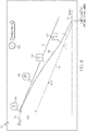
- FIG. 7 illustrates an exemplary VNAV display 70 that can be generated by cockpit display system 10 ( FIG. 1 ) under a further landing scenario.
- VNAV display 70 includes an aircraft symbol 72, a runway symbol 74, a current trajectory profile 76, and an ideal trajectory profile 78 as calculated by a controller 14 shown in FIG. 1 or another flight computer deployed onboard the aircraft. Additionally, as shown in FIG. 7 , VNAV display 70 includes a predicted trajectory profile 82 and one or more drag device deployment markers or cues 84, 86, which indicate a deployment scheme that can be employed to capture the flight computer-computed ideal trajectory profile 78.
- the deployment cues 84, 86 include an airbrake deployment cue 84 and a first flap deployment cue 86.
- VNAV display 70 is generated to include an overall assessment icon and message 80, which indicates that the displayed landing option is currently classified in the HIGH FEASIBILITY (GREEN) landing category.
- predicted trajectory profile 82 may also be color coded green to further indicate that the landing option is presently assessed as highly feasible.
- VNAV display 70 not only visually conveys the top-level assessment of the landing option, but further graphically indicates the rationale underlying the top-level assessment; here, that the aircraft can be stabilized well-ahead of the final landing gate by deployment of the aircraft drag devices in the manner shown.
- a pilot can obtain further operational and feasibility details for expanded SA and execution planning of a landing diversion. This can boost pilot confidence in the overall landing feasibility and safety assessment provided by cockpit display system 10 ( FIG. 1 ) or a planned airport or diversion option.
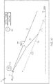
- FIG. 8 illustrates VNAV display 70 under additional landing scenario in which the depicted landing option (the designated airport or selected diversion airport) has been assigned to the MID FEASIBILITY (AMBER) landing category.
- Cockpit display system 10 has assessed the chosen diversion option (or the designated airport with changed landing parameters) to be moderately feasible as the aircraft is predicted to stabilize beyond the final landing gate, while the predicted touchdown point indicatives that aircraft will be able to safely stop well within the available runway.
- predicted trajectory profile 82 may be color coded amber to further indicate that the landing option is considered moderately feasible.
- FIGs. 9 and 10 illustrate VNAV display 70 in still further landing scenarios wherein the chosen landing option has been assigned to the MID FEASIBILITY (AMBER) landing category for tactical reasons.
- the diversion option has been determined to be tactically feasible with moderate workload, providing that the pilot commands the vertical speed of the aircraft.
- cockpit display system 10 FIG. 1
- cockpit display system 10 can produce display 70 to further include an ideal descent rate indicator 82. This assists piloting the aircraft in a Vertical Speed (V/S) mode with a DFO recommended descent rate and without a flight computer-guided descent.
- a pilot can utilize pilot interface 22 ( FIG.
- predicted trajectory profile 82 may be color coded amber in FIGs. 9 and 10 to indicate that the landing option has been assessed to be moderately feasible by cockpit display system 10 ( FIG. 1 ).
- FIG. 11 illustrates VNAV display 70 under a landing scenario in which the depicted landing option has been assigned to the LOW FEASIBILITY (RED) landing category.
- This assignment may indicate that cockpit display system 10 has determined that is unfeasible to achieve either a stabilized landing or safe stopping at the landing option (the designated airport or the selected diversion option) without changed landing parameters.
- cockpit display system 10 can generate an advisory message on display 70. For example, in instances wherein the altitude of the aircraft is above a minimum altitude threshold, a "Short Runway" advisory message (shown) can be presented so that pilot can evaluate other alternate diversion options.
- a "Short Runway" advisory message shown
- Predicted trajectory profile 82 may be color coded red in such scenarios to indicate that the landing option has been assessed to be unfeasible by cockpit display system 10 ( FIG. 1 ).
- cockpit display system 10 may further enable a ground controller (e.g., ATC 34 shown in FIG. 1 ) to view the landing category assigned to the airport at which the aircraft is currently scheduled to land.
- a ground controller e.g., ATC 34 shown in FIG. 1
- FIG. 12 an ATC display 90 can be generated to included range rings 92, intruder aircraft symbols 94, tower symbol 96, and ownship aircraft symbol 98.
- ownship aircraft symbol 98 is color coded red to denote that, in this example, the ownship aircraft is scheduled to execute a landing that has been flagged as having little to no feasibility. This alerts the ATC to a potential need to assess and execute a landing diversion for the ownship aircraft.
- the pilot's decisions can be communicated to ground controllers automatically through CPDLC link.
- the ground controllers can thus be kept informed as to whether a pilot has accepted or rejected the diversion proposed by ground controllers or if, instead, the pilot is proposing to clear for more feasible and safer options based upon diversion feasibility assessment provided by embodiments of the present invention.
- the overall workload involved in manual information exchanges and negotiating with ground controllers is significantly reduced as a result.
- cockpit display systems and methods for generating navigation displays including landing diversion symbology which aid pilot decision-making when investigating the possibility of diverting from a planned landing.
- embodiments of the above-described navigation displays provide novel decision and operational aids to facilitate rapid pilot decisions regarding the feasibility and safety of landing operations under landing diversion conditions.
- the proposed decision aids can be implemented based upon a temporary flight plan by considering dynamic parameters (e.g. weather, runway condition, winds, aircraft energy content, runway and airport availability, etc.) to provide landing feasibility and safety assessments with operational directions to dissipate energy.
- the cockpit display system continually evaluates the dynamic parameters and provides periodic assessment to make sure the relevance of its assessments.
- the above-described navigation displays assist the pilot in rendering landing diversion conditions without immersing into detailed information integration and situation assessment task in the event of situations requiring diversion or change of landing parameters at the planned destination airport.
- the cockpit display system and the above-described methods can enable a ground controller to view a pilot's situational challenges regarding assigned landing parameters. In this manner, negotiations between the pilot and the ground controller regarding landing diversions and other changes in landing parameters (e.g., Standard Terminal Arrival Routes) can be eased.
- embodiments of the cockpit display system and the associated methods can automatically detect situations in which assessment of landing feasibility and safety is warranted, whether in response to a changed landing parameters or diversion of the flight to an alternative airport.
- the cockpit display system can provide quick situation awareness and assessment aids for pilot to take GO or NO GO decisions by accepting or rejecting the changes in landing parameters of planned airport, as instructed by ground controller, or by selecting the most feasible and safe alternate airport during a landing diversion.
- the cockpit display system can provide a holistic view of available alternate airports based upon feasibility and safety evaluated with respect to various conditions, such as terminal weather, winds, available runways, respective runway length, runway conditions, fuel on board, and present energy contents of the aircraft.
- the cockpit display system further visually convey the landing diversion assessment through an intuitive and widely-recognized 'GREEN-AMBER-RED' color coding scheme.
- An intuitive justification can be further provided by the cockpit control system for its assessments. This justification can be provided by projecting the feasibility/unfeasibility assessment on a vertical situation display where details of predicted trajectory and its divergence with ideal descent path as computed by flight computer. Additionally, as described above, drag devices deployment schedule and advisories can also be produced on the vertical situation display. Effectiveness and productivity of pilot-controller communication can also be improved by enabling controller to have a peek view of feasibility and safety assessment performed by the proposed invention.
Landscapes
- Engineering & Computer Science (AREA)
- Radar, Positioning & Navigation (AREA)
- Remote Sensing (AREA)
- Aviation & Aerospace Engineering (AREA)
- Physics & Mathematics (AREA)
- General Physics & Mathematics (AREA)
- Business, Economics & Management (AREA)
- Emergency Management (AREA)
- Traffic Control Systems (AREA)
Claims (9)
- Système d'affichage de cockpit (10) destiné au déploiement à bord d'un aéronef, ledit système d'affichage de cockpit comprenant :un moniteur de cockpit (18) ; etun dispositif de commande (14) couplé au moniteur de cockpit (18) et conçu :pour évaluer la faisabilité actuelle d'atterrissage à une première option d'atterrissage, la première option d'atterrissage étant l'un d'au moins un aéroport dans une plage de l'aéronef ;pour attribuer la première option d'atterrissage à l'une catégorie d'une pluralité de catégories de faisabilité d'atterrissage prédéterminées comprenant au moins une catégorie d'atterrissage à haute faisabilité et une catégorie d'atterrissage à faible faisabilité ; etpour générer un affichage de navigation (70) vertical sur le moniteur de cockpit ;dans lequel le dispositif de commande génère l'affichage de navigation vertical pour inclure des graphiques indicatifs de la catégorie de faisabilité attribuée à la première option d'atterrissage (80), un profil de trajectoire idéale (78) pour la première option d'atterrissage et un profil de trajectoire prédite (82) de l'aéronef ; etdans lequel le dispositif de commande génère en outre, sur l'affichage de navigation vertical, au moins un indice de déploiement de dispositif de freinage (84, 86) indiquant un schéma de déploiement de dispositif de freinage, lequel peut être utilisé pour capturer le profil de trajectoire idéale lorsque la catégorie de haute faisabilité est attribuée à la première option d'atterrissage.
- Système d'affichage de cockpit (10) selon la revendication 1, dans lequel les graphiques comprennent une icône à code couleur (80) générée sur l'affichage de navigation (70) vertical et comportant une couleur indicative de la catégorie de faisabilité attribuée à la première option d'atterrissage.
- Système d'affichage de cockpit (10) selon la revendication 1, dans lequel les graphiques comprennent un message textuel indiquant la catégorie de faisabilité attribuée à la première option d'atterrissage.
- Système d'affichage de cockpit (10) selon la revendication 1, comprenant en outre un dispositif d'entrée (22) couplé au dispositif de commande (14), le dispositif de commande étant en outre conçu :pour recevoir des données du dispositif d'entrée par sélection de la première option d'atterrissage parmi une pluralité d'aéroports de déroutement présentés sur un affichage de navigation (50) horizontal ; etpour générer l'affichage de navigation (70) vertical en réponse à la réception des données par sélection de la première option d'atterrissage.
- Système d'affichage de cockpit (10) selon la revendication 1, dans lequel le dispositif de commande (14) est en outre conçu pour générer le profil de trajectoire prédite (82) sous la forme d'un graphique à code couleur comportant une couleur indicative de la catégorie de faisabilité attribuée à la première option d'atterrissage.
- Système d'affichage de cockpit (10) selon la revendication 1, dans lequel le dispositif de commande (14) est en outre conçu pour générer un message d'avertissement de remise de gaz sur l'affichage de navigation vertical lors de la détermination que la première option d'atterrissage est irréalisable et que l'aéronef est en dessous d'un seuil d'altitude minimum.
- Système d'affichage de cockpit (10) selon la revendication 1, comprenant en outre un sous-système de liaison de données (26) couplé de manière fonctionnelle au dispositif de commande (14) et permettant la communication avec un contrôleur de la circulation aérienne (ATC, Air Traffic Controller ; 34) distant de l'aéronef, et dans lequel le dispositif de commande est en outre conçu :pour évaluer la faisabilité actuelle d'atterrissage à un aéroport désigné où l'aéronef doit atterrir ;pour attribuer l'aéroport désigné à une catégorie de la pluralité de catégories de faisabilité d'atterrissage prédéterminées ; etpour envoyer des données à l'ATC par l'intermédiaire du sous-système de liaison de données indiquant la catégorie de faisabilité d'atterrissage à laquelle l'aéroport désigné a été attribué.
- Système d'affichage de cockpit (10) selon la revendication 1, dans lequel le dispositif de commande (14) est en outre conçu pour générer des graphiques sur un affichage de navigation horizontal (50) indiquant au moins un point auquel un dispositif de freinage de l'aéronef doit être déployé lors de l'atterrissage à la première option d'atterrissage.
- Procédé mis en œuvre par le système d'affichage de cockpit (10) d'un aéronef, ledit système d'affichage de cockpit comprenant un dispositif de commande (14) et un moniteur de cockpit (18) couplé de manière fonctionnelle au dispositif de commande, ledit procédé comprenant :l'évaluation, au niveau du dispositif de commande, de la faisabilité actuelle d'atterrissage à une première option d'atterrissage, la première option d'atterrissage étant l'un d'au moins un aéroport dans une plage de l'aéronef ;l'attribution, au niveau du dispositif de commande, de la première option d'atterrissage à une catégorie d'une pluralité de catégories de faisabilité d'atterrissage prédéterminées comprenant au moins une catégorie d'atterrissage à haute faisabilité et une catégorie d'atterrissage à faible faisabilité ; et la génération d'un affichage de navigation vertical (50) sur le moniteur de cockpit ;dans lequel l'affichage de navigation vertical est généré pour inclure des graphiques indicatifs de la catégorie de faisabilité attribuée à la première option d'atterrissage, un profil de trajectoire idéale (78) pour la première option d'atterrissage et un profil de trajectoire prédite (82) de l'aéronef ; etdans lequel le dispositif de commande génère en outre, sur l'affichage de navigation vertical, au moins un indice de déploiement de dispositif de freinage (84, 86) indiquant un schéma de déploiement de dispositif de freinage, lequel peut être utilisé pour capturer le profil de trajectoire idéale lorsque la catégorie de haute faisabilité est attribuée à la première option d'atterrissage.
Applications Claiming Priority (1)
| Application Number | Priority Date | Filing Date | Title |
|---|---|---|---|
| US14/619,849 US9646503B2 (en) | 2015-02-11 | 2015-02-11 | Cockpit display systems and methods for generating navigation displays including landing diversion symbology |
Publications (2)
| Publication Number | Publication Date |
|---|---|
| EP3056864A1 EP3056864A1 (fr) | 2016-08-17 |
| EP3056864B1 true EP3056864B1 (fr) | 2020-12-23 |
Family
ID=55300428
Family Applications (1)
| Application Number | Title | Priority Date | Filing Date |
|---|---|---|---|
| EP16154358.2A Active EP3056864B1 (fr) | 2015-02-11 | 2016-02-04 | Systèmes d'affichage de cockpits et procédés pour générer des affichages de navigation comprenant une symbologie de diversion d'atterrissage |
Country Status (3)
| Country | Link |
|---|---|
| US (1) | US9646503B2 (fr) |
| EP (1) | EP3056864B1 (fr) |
| CN (1) | CN105890622B (fr) |
Families Citing this family (49)
| Publication number | Priority date | Publication date | Assignee | Title |
|---|---|---|---|---|
| ES2668896T3 (es) * | 2013-12-31 | 2018-05-23 | The Boeing Company | Sistema y método para definir y predecir trayectorias de aeronave |
| US10068488B2 (en) * | 2015-04-30 | 2018-09-04 | Ge Aviation Systems Llc | Systems and methods of providing a data update to an aircraft |
| EP3104122A1 (fr) * | 2015-06-12 | 2016-12-14 | Ecole Nationale de l'Aviation Civile | Systeme de gestion d'energie pour vehicules |
| US10096253B2 (en) | 2015-11-30 | 2018-10-09 | Honeywell International Inc. | Methods and systems for presenting diversion destinations |
| US10134292B2 (en) * | 2015-12-07 | 2018-11-20 | Airbus Group India Private Limited | Navigating and guiding an aircraft to a reachable airport during complete engine failure |
| US10152195B2 (en) | 2015-12-14 | 2018-12-11 | Honeywell International Inc. | Aircraft display system pertaining to energy management |
| US10304344B2 (en) | 2016-02-09 | 2019-05-28 | Honeywell International Inc. | Methods and systems for safe landing at a diversion airport |
| CN105652884A (zh) * | 2016-02-15 | 2016-06-08 | 英华达(上海)科技有限公司 | 无人机飞行方法以及无人机飞行系统 |
| US10134289B2 (en) | 2016-02-18 | 2018-11-20 | Honeywell International Inc. | Methods and systems facilitating stabilized descent to a diversion airport |
| FR3050291B1 (fr) * | 2016-04-15 | 2020-02-28 | Thales | Procede d'affichage de donnees pour la gestion du vol d'un aeronef, produit programme d'ordinateur et systeme associes |
| US9884690B2 (en) * | 2016-05-03 | 2018-02-06 | Honeywell International Inc. | Methods and systems for conveying destination viability |
| US10109203B2 (en) * | 2016-09-07 | 2018-10-23 | Honeywell International Inc. | Methods and systems for presenting en route diversion destinations |
| US10000297B2 (en) * | 2016-09-29 | 2018-06-19 | Honeywell International Inc. | Aircraft display systems and methods for generating horizontal situation indicator graphics with enhanced symbology |
| US10678265B2 (en) * | 2016-10-19 | 2020-06-09 | Airbus Sas | Revised speed advisory for an aircraft during flight based on holding time |
| US10540899B2 (en) | 2016-11-21 | 2020-01-21 | Honeywell International Inc. | Flight plan segmentation for en route diversion destinations |
| US10139246B1 (en) * | 2016-12-07 | 2018-11-27 | Rockwell Collins, Inc. | Enhanced vertical path (VPATH) inhibit logic for vertical situation display (VSD) |
| US10150573B2 (en) * | 2017-01-04 | 2018-12-11 | Honeywell International Inc. | Methods and apparatus for presenting automatic flight control system data onboard an aircraft |
| US10388171B2 (en) * | 2017-02-15 | 2019-08-20 | Honeywell International Inc. | Cockpit display systems and methods for generating cockpit displays including direct approach energy management symbology |
| US10094682B2 (en) * | 2017-02-22 | 2018-10-09 | Honeywell International Inc. | Cockpit display systems and methods for performing glide slope validation processes during instrument landing system approaches |
| US10297159B2 (en) | 2017-03-17 | 2019-05-21 | Honeywell International Inc. | Systems and methods for graphical visualization of communication transmissions received onboard an aircraft |
| US10654589B2 (en) * | 2017-03-27 | 2020-05-19 | Honeywell International Inc. | Avionic display systems and methods for generating vertical situation displays including instability prediction and avoidance symbology |
| FR3065567B1 (fr) * | 2017-04-24 | 2021-04-16 | Airbus Operations Sas | Procede de transmission de parametres de vol d'un aeronef meneur vers un aeronef intrus |
| US10896618B2 (en) | 2017-05-03 | 2021-01-19 | Honeywell International Inc. | System and method for determining diversion airports for landing in adverse conditions |
| FR3067802B1 (fr) * | 2017-06-16 | 2019-12-13 | Thales | Gestion de routes alternatives pour un aeronef |
| US10607493B2 (en) * | 2017-08-22 | 2020-03-31 | The Boeing Company | Aircraft arrival determination systems and methods |
| CN109841093B (zh) * | 2017-11-28 | 2022-08-12 | 上海航空电器有限公司 | 一种近地告警系统中的飞机着陆机场识别方法 |
| US20200365041A1 (en) * | 2018-01-10 | 2020-11-19 | Qualcomm Incorporated | Identifying landing zones for landing of a robotic vehicle |
| US11225762B2 (en) * | 2018-05-07 | 2022-01-18 | Gannett Fleming Inc. | Modular landing port |
| US10741149B2 (en) | 2018-05-23 | 2020-08-11 | Honeywell International Inc. | Assisted visual separation enhanced by graphical visualization |
| US10839701B2 (en) | 2018-06-05 | 2020-11-17 | Honeywell International Inc. | Methods and systems for stabilized approach energy management |
| US10854091B2 (en) | 2018-07-03 | 2020-12-01 | Honeywell International Inc. | Energy management visualization methods and systems |
| US10909858B2 (en) * | 2018-09-28 | 2021-02-02 | The Boeing Company | Aircraft flight management systems and methods |
| US11104449B2 (en) * | 2019-01-17 | 2021-08-31 | Honeywell Interntional Inc. | Significant weather advisory system |
| CN113874929A (zh) * | 2019-05-23 | 2021-12-31 | 智慧天空网络有限公司 | 通过双向连接在飞机驾驶舱中实现增强现实 |
| US11355022B2 (en) * | 2019-09-13 | 2022-06-07 | Honeywell International Inc. | Systems and methods for computing flight controls for vehicle landing |
| US20210082290A1 (en) * | 2019-09-13 | 2021-03-18 | The Boeing Company | Determining an airport for landing an aircraft |
| EP3813038A1 (fr) * | 2019-10-24 | 2021-04-28 | Airbus Operations SAS | Procédé et système pour faciliter l'atterrissage d'un aéronef |
| FR3104706B1 (fr) * | 2019-12-13 | 2021-12-31 | Airbus Operations Sas | Système et procédé d’aide à l’atterrissage d’un aéronef lors d’une panne totale des moteurs de l’aéronef. |
| US11525699B2 (en) | 2020-02-13 | 2022-12-13 | Honeywell International Inc. | Radar vectoring energy management guidance methods and systems |
| US11790795B2 (en) | 2020-04-13 | 2023-10-17 | Honeywell International Inc. | System and methods enabling aircraft energy dissipation for rapid decision making |
| US11551562B2 (en) | 2020-05-14 | 2023-01-10 | The Boeing Company | Efficient flight planning for regions with high elevation terrain |
| US11897596B2 (en) * | 2020-07-21 | 2024-02-13 | The Boeing Company | Methods and apparatus for automatically extending aircraft wing flaps in response to detecting an excess energy steep descent condition |
| US11574549B2 (en) * | 2020-10-19 | 2023-02-07 | Honeywell International Inc. | Composite vertical profile display systems and methods |
| US11645924B2 (en) | 2020-10-29 | 2023-05-09 | Honeywell International Inc. | Variable energy management methods and systems |
| US11842629B2 (en) | 2020-12-10 | 2023-12-12 | Honeywell International Inc. | Dynamic radar vectoring guidance methods and systems |
| US11724820B2 (en) | 2020-12-24 | 2023-08-15 | Ge Aviation Systems Llc | Decision-support system for aircraft requiring emergency landings |
| EP4050585A1 (fr) | 2021-02-24 | 2022-08-31 | Honeywell International Inc. | Procédés et systèmes permettant une modélisation efficace de train d'atterrissage pour la gestion d'énergie |
| CN114636417B (zh) * | 2022-05-23 | 2022-09-02 | 珠海翔翼航空技术有限公司 | 基于图像识别的飞行器迫降路径规划方法、系统和设备 |
| US20240021087A1 (en) * | 2022-07-12 | 2024-01-18 | The Boeing Company | Holding detection and diversion information |
Citations (2)
| Publication number | Priority date | Publication date | Assignee | Title |
|---|---|---|---|---|
| EP2362289A2 (fr) * | 2010-02-24 | 2011-08-31 | Honeywell International Inc. | Procédés et systèmes d'affichage de paramètres de liaison descendante prévue dans un affichage de profil vertical |
| US20120310450A1 (en) * | 2011-06-06 | 2012-12-06 | Honeywell International Inc. | Methods and systems for briefing aircraft procedures |
Family Cites Families (31)
| Publication number | Priority date | Publication date | Assignee | Title |
|---|---|---|---|---|
| DE19604931A1 (de) | 1996-02-10 | 1997-08-14 | Nfs Navigations Und Flugfuehru | Verfahren zur Korrektur des Flugablaufs eines Fluggerätes |
| US6154151A (en) | 1998-06-16 | 2000-11-28 | Rockwell Collins, Inc. | Integrated vertical situation display for aircraft |
| US7436323B2 (en) | 2001-02-02 | 2008-10-14 | Honeywell International Inc. | Method, apparatus and computer program product for unstabilized approach alerting |
| FR2822944B1 (fr) * | 2001-03-27 | 2003-08-29 | Eads Airbus Sa | Procede et dispositif d'assistance au pilotage d'un aeronef, notamment d'un avion de transport |
| US7735005B2 (en) | 2003-09-11 | 2010-06-08 | The Boeing Company | Style guide and formatting methods for pilot quick reference handbooks |
| FR2898672B1 (fr) | 2006-03-14 | 2009-07-03 | Thales Sa | Procede d'aide a la navigation d'un aeronef avec une mise a jour du plan de vol |
| US8164485B2 (en) | 2006-04-13 | 2012-04-24 | The United States Of America As Represented By The Administrator Of The National Aeronautics And Space Administration | System and method for aiding pilot preview, rehearsal, review, and real-time visual acquisition of flight mission progress |
| US7693621B1 (en) | 2006-06-27 | 2010-04-06 | Toyota Motor Sales, U.S.A., Inc. | Apparatus and methods for displaying arrival, approach, and departure information on a display device in an aircraft |
| FR2915304B1 (fr) | 2007-04-20 | 2009-06-05 | Thales Sa | Procede de calcul de trajectoire d'approche pour aeronef |
| FR2915610B1 (fr) | 2007-04-24 | 2009-07-10 | Thales Sa | Procede de calcul d'une trajectoire d'approche d'un aeronef vers un aeroport |
| US20100070110A1 (en) | 2008-09-10 | 2010-03-18 | Honeywell International Inc. | Methods and systems for indicating fuel required to reach a location |
| FR2940426B1 (fr) * | 2008-12-23 | 2010-12-10 | Thales Sa | Dispositif d'assistance au choix d'un aeroport de deroutement |
| US8321069B2 (en) | 2009-03-26 | 2012-11-27 | Honeywell International Inc. | Methods and systems for reviewing datalink clearances |
| US8195347B2 (en) | 2009-05-28 | 2012-06-05 | The Boeing Company | Method and system for approach decision display |
| US8565944B1 (en) * | 2009-10-13 | 2013-10-22 | The Boeing Company | Alternate diversion airport planner |
| FR2953627B1 (fr) | 2009-12-04 | 2012-07-13 | Thales Sa | Procede d'aide a la rejointe d'une trajectoire verticale de descente et dispositif associe |
| US8660716B1 (en) | 2010-05-03 | 2014-02-25 | The Boeing Company | Comparative vertical situation displays |
| US9020681B2 (en) * | 2010-06-08 | 2015-04-28 | Honeywell International Inc. | Display of navigation limits on an onboard display element of a vehicle |
| US8560150B1 (en) | 2010-07-07 | 2013-10-15 | The Boeing Company | Methods and systems for landing decision point |
| FR2971863B1 (fr) * | 2011-02-17 | 2014-05-23 | Airbus Operations Sas | Procede et dispositif d'aide a la gestion du vol d'un aeronef. |
| CN103890720B (zh) | 2011-10-13 | 2017-07-11 | 伊莱克斯家用产品股份有限公司 | 器具上的带有上下文快捷方式的屏幕即时帮助 |
| GB2500390A (en) | 2012-03-19 | 2013-09-25 | Ge Aviat Systems Ltd | Audio-visual briefing for flight-crew with data relevant to particular flight phases |
| FR2993975B1 (fr) * | 2012-07-27 | 2016-02-05 | Thales Sa | Procede d'affichage de la situation geographique d'un aeronef |
| FR2994286B1 (fr) | 2012-08-02 | 2014-08-22 | Airbus Operations Sas | Procede et dispositif d'aide a la gestion du vol d'un aeronef |
| US20140129058A1 (en) | 2012-11-07 | 2014-05-08 | Honeywell International Inc. | System and method for enhancing pilot decision making during landing in challenging weather |
| CN102980573A (zh) * | 2012-11-19 | 2013-03-20 | 中国航空工业集团公司第六三一研究所 | 通用飞机着陆径向线导航方法 |
| US20140343765A1 (en) * | 2012-12-28 | 2014-11-20 | Sean Patrick Suiter | Flight Assistant with Automatic Configuration and Landing Site Selection |
| US9567099B2 (en) | 2013-04-11 | 2017-02-14 | Airbus Operations (S.A.S.) | Aircraft flight management devices, systems, computer readable media and related methods |
| US9126694B2 (en) * | 2013-07-15 | 2015-09-08 | Honeywell International Inc. | Display systems and methods for providing displays having an integrated autopilot functionality |
| US8977484B1 (en) * | 2013-08-22 | 2015-03-10 | The Boeing Company | Using aircraft trajectory data to infer aircraft intent |
| US9352848B2 (en) * | 2013-11-06 | 2016-05-31 | The Boeing Company | Flight deck touch screen interface for interactive displays |
-
2015
- 2015-02-11 US US14/619,849 patent/US9646503B2/en active Active
-
2016
- 2016-02-04 EP EP16154358.2A patent/EP3056864B1/fr active Active
- 2016-02-05 CN CN201610164078.6A patent/CN105890622B/zh active Active
Patent Citations (2)
| Publication number | Priority date | Publication date | Assignee | Title |
|---|---|---|---|---|
| EP2362289A2 (fr) * | 2010-02-24 | 2011-08-31 | Honeywell International Inc. | Procédés et systèmes d'affichage de paramètres de liaison descendante prévue dans un affichage de profil vertical |
| US20120310450A1 (en) * | 2011-06-06 | 2012-12-06 | Honeywell International Inc. | Methods and systems for briefing aircraft procedures |
Also Published As
| Publication number | Publication date |
|---|---|
| CN105890622A (zh) | 2016-08-24 |
| CN105890622B (zh) | 2021-07-30 |
| US20160229554A1 (en) | 2016-08-11 |
| US9646503B2 (en) | 2017-05-09 |
| EP3056864A1 (fr) | 2016-08-17 |
Similar Documents
| Publication | Publication Date | Title |
|---|---|---|
| EP3056864B1 (fr) | Systèmes d'affichage de cockpits et procédés pour générer des affichages de navigation comprenant une symbologie de diversion d'atterrissage | |
| US11024181B2 (en) | Systems and methods for generating avionic displays including forecast overpressure event symbology | |
| US9266621B2 (en) | Display systems and methods for providing displays indicating a required time of arrival | |
| EP3048424B1 (fr) | Procédés et systèmes pour affichage d'informations de prévisions météorologiques sur la base d'un itinéraire | |
| US9199724B2 (en) | System and method for performing an aircraft automatic emergency descent | |
| US10157617B2 (en) | System and method for rendering an aircraft cockpit display for use with ATC conditional clearance instructions | |
| EP3693706A1 (fr) | Système et procédé permettant d'obtenir une meilleure navigation dans l'ihm | |
| CN111540238B (zh) | 基于至少呼叫(squawk)代码来识别、描绘和警告遇险和特殊交通的系统和方法 | |
| US8781649B2 (en) | System and method for displaying in-trail procedure (ITP) opportunities on an aircraft cockpit display | |
| EP2741053B1 (fr) | Procédé de génération graphique de cours d'approche | |
| US11275388B2 (en) | Systems and methods for an enhanced stable approach monitor | |
| EP2790167A2 (fr) | Système et procédé d'affichage de symboles sur un écran d'affichage de procédure in-trail textuellement et graphiquement représentatif d'un scénario de trafic vertical et de négociation de contrôle de trafic aérien | |
| US9401091B2 (en) | System and method for displaying In-Trail Procedure (ITP) allocations on an aircraft cockpit display | |
| US10565883B2 (en) | Systems and methods for managing practice airspace | |
| CN109839949B (zh) | 安全音速高度生成 | |
| Young | Understanding Crew Decision-Making in the Presence of Complexity-A Flight Simulation Experiment | |
| EP2913813B1 (fr) | Système et procédé de sélection de pistes par l'intermédiaire de notation | |
| EP3470791A1 (fr) | Procédé et système pour fournir une autocorrélation contextuelle d'objets d'affichage de situation verticale à des objets affichés sur une carte latérale basé sur un schéma de priorité | |
| US8478513B1 (en) | System and method for displaying degraded traffic data on an in-trail procedure (ITP) display | |
| US10565886B2 (en) | Systems and methods for predicting loss of separation events | |
| EP3926607A1 (fr) | Procédés, systèmes et appareils permettant d'identifier et d'indiquer les procédures d'approche au point de visée de piste secondaire (srap) |
Legal Events
| Date | Code | Title | Description |
|---|---|---|---|
| PUAI | Public reference made under article 153(3) epc to a published international application that has entered the european phase |
Free format text: ORIGINAL CODE: 0009012 |
|
| 17P | Request for examination filed |
Effective date: 20160204 |
|
| AK | Designated contracting states |
Kind code of ref document: A1 Designated state(s): AL AT BE BG CH CY CZ DE DK EE ES FI FR GB GR HR HU IE IS IT LI LT LU LV MC MK MT NL NO PL PT RO RS SE SI SK SM TR |
|
| AX | Request for extension of the european patent |
Extension state: BA ME |
|
| STAA | Information on the status of an ep patent application or granted ep patent |
Free format text: STATUS: EXAMINATION IS IN PROGRESS |
|
| 17Q | First examination report despatched |
Effective date: 20180316 |
|
| REG | Reference to a national code |
Ref country code: DE Ref legal event code: R079 Ref document number: 602016050109 Country of ref document: DE Free format text: PREVIOUS MAIN CLASS: G01C0023000000 Ipc: G08G0005000000 |
|
| GRAP | Despatch of communication of intention to grant a patent |
Free format text: ORIGINAL CODE: EPIDOSNIGR1 |
|
| STAA | Information on the status of an ep patent application or granted ep patent |
Free format text: STATUS: GRANT OF PATENT IS INTENDED |
|
| RIC1 | Information provided on ipc code assigned before grant |
Ipc: G01C 23/00 20060101ALI20200729BHEP Ipc: G08G 5/02 20060101ALI20200729BHEP Ipc: G08G 5/00 20060101AFI20200729BHEP |
|
| INTG | Intention to grant announced |
Effective date: 20200819 |
|
| RAP1 | Party data changed (applicant data changed or rights of an application transferred) |
Owner name: HONEYWELL INTERNATIONAL INC. |
|
| GRAS | Grant fee paid |
Free format text: ORIGINAL CODE: EPIDOSNIGR3 |
|
| GRAA | (expected) grant |
Free format text: ORIGINAL CODE: 0009210 |
|
| STAA | Information on the status of an ep patent application or granted ep patent |
Free format text: STATUS: THE PATENT HAS BEEN GRANTED |
|
| AK | Designated contracting states |
Kind code of ref document: B1 Designated state(s): AL AT BE BG CH CY CZ DE DK EE ES FI FR GB GR HR HU IE IS IT LI LT LU LV MC MK MT NL NO PL PT RO RS SE SI SK SM TR |
|
| REG | Reference to a national code |
Ref country code: GB Ref legal event code: FG4D |
|
| REG | Reference to a national code |
Ref country code: DE Ref legal event code: R096 Ref document number: 602016050109 Country of ref document: DE |
|
| REG | Reference to a national code |
Ref country code: AT Ref legal event code: REF Ref document number: 1348479 Country of ref document: AT Kind code of ref document: T Effective date: 20210115 |
|
| REG | Reference to a national code |
Ref country code: IE Ref legal event code: FG4D |
|
| PG25 | Lapsed in a contracting state [announced via postgrant information from national office to epo] |
Ref country code: NO Free format text: LAPSE BECAUSE OF FAILURE TO SUBMIT A TRANSLATION OF THE DESCRIPTION OR TO PAY THE FEE WITHIN THE PRESCRIBED TIME-LIMIT Effective date: 20210323 Ref country code: RS Free format text: LAPSE BECAUSE OF FAILURE TO SUBMIT A TRANSLATION OF THE DESCRIPTION OR TO PAY THE FEE WITHIN THE PRESCRIBED TIME-LIMIT Effective date: 20201223 Ref country code: FI Free format text: LAPSE BECAUSE OF FAILURE TO SUBMIT A TRANSLATION OF THE DESCRIPTION OR TO PAY THE FEE WITHIN THE PRESCRIBED TIME-LIMIT Effective date: 20201223 Ref country code: GR Free format text: LAPSE BECAUSE OF FAILURE TO SUBMIT A TRANSLATION OF THE DESCRIPTION OR TO PAY THE FEE WITHIN THE PRESCRIBED TIME-LIMIT Effective date: 20210324 |
|
| REG | Reference to a national code |
Ref country code: AT Ref legal event code: MK05 Ref document number: 1348479 Country of ref document: AT Kind code of ref document: T Effective date: 20201223 |
|
| REG | Reference to a national code |
Ref country code: NL Ref legal event code: MP Effective date: 20201223 |
|
| PG25 | Lapsed in a contracting state [announced via postgrant information from national office to epo] |
Ref country code: BG Free format text: LAPSE BECAUSE OF FAILURE TO SUBMIT A TRANSLATION OF THE DESCRIPTION OR TO PAY THE FEE WITHIN THE PRESCRIBED TIME-LIMIT Effective date: 20210323 Ref country code: SE Free format text: LAPSE BECAUSE OF FAILURE TO SUBMIT A TRANSLATION OF THE DESCRIPTION OR TO PAY THE FEE WITHIN THE PRESCRIBED TIME-LIMIT Effective date: 20201223 Ref country code: LV Free format text: LAPSE BECAUSE OF FAILURE TO SUBMIT A TRANSLATION OF THE DESCRIPTION OR TO PAY THE FEE WITHIN THE PRESCRIBED TIME-LIMIT Effective date: 20201223 |
|
| PG25 | Lapsed in a contracting state [announced via postgrant information from national office to epo] |
Ref country code: HR Free format text: LAPSE BECAUSE OF FAILURE TO SUBMIT A TRANSLATION OF THE DESCRIPTION OR TO PAY THE FEE WITHIN THE PRESCRIBED TIME-LIMIT Effective date: 20201223 Ref country code: NL Free format text: LAPSE BECAUSE OF FAILURE TO SUBMIT A TRANSLATION OF THE DESCRIPTION OR TO PAY THE FEE WITHIN THE PRESCRIBED TIME-LIMIT Effective date: 20201223 |
|
| REG | Reference to a national code |
Ref country code: LT Ref legal event code: MG9D |
|
| PG25 | Lapsed in a contracting state [announced via postgrant information from national office to epo] |
Ref country code: SK Free format text: LAPSE BECAUSE OF FAILURE TO SUBMIT A TRANSLATION OF THE DESCRIPTION OR TO PAY THE FEE WITHIN THE PRESCRIBED TIME-LIMIT Effective date: 20201223 Ref country code: PT Free format text: LAPSE BECAUSE OF FAILURE TO SUBMIT A TRANSLATION OF THE DESCRIPTION OR TO PAY THE FEE WITHIN THE PRESCRIBED TIME-LIMIT Effective date: 20210423 Ref country code: RO Free format text: LAPSE BECAUSE OF FAILURE TO SUBMIT A TRANSLATION OF THE DESCRIPTION OR TO PAY THE FEE WITHIN THE PRESCRIBED TIME-LIMIT Effective date: 20201223 Ref country code: CZ Free format text: LAPSE BECAUSE OF FAILURE TO SUBMIT A TRANSLATION OF THE DESCRIPTION OR TO PAY THE FEE WITHIN THE PRESCRIBED TIME-LIMIT Effective date: 20201223 Ref country code: EE Free format text: LAPSE BECAUSE OF FAILURE TO SUBMIT A TRANSLATION OF THE DESCRIPTION OR TO PAY THE FEE WITHIN THE PRESCRIBED TIME-LIMIT Effective date: 20201223 Ref country code: SM Free format text: LAPSE BECAUSE OF FAILURE TO SUBMIT A TRANSLATION OF THE DESCRIPTION OR TO PAY THE FEE WITHIN THE PRESCRIBED TIME-LIMIT Effective date: 20201223 Ref country code: LT Free format text: LAPSE BECAUSE OF FAILURE TO SUBMIT A TRANSLATION OF THE DESCRIPTION OR TO PAY THE FEE WITHIN THE PRESCRIBED TIME-LIMIT Effective date: 20201223 |
|
| PG25 | Lapsed in a contracting state [announced via postgrant information from national office to epo] |
Ref country code: PL Free format text: LAPSE BECAUSE OF FAILURE TO SUBMIT A TRANSLATION OF THE DESCRIPTION OR TO PAY THE FEE WITHIN THE PRESCRIBED TIME-LIMIT Effective date: 20201223 Ref country code: AT Free format text: LAPSE BECAUSE OF FAILURE TO SUBMIT A TRANSLATION OF THE DESCRIPTION OR TO PAY THE FEE WITHIN THE PRESCRIBED TIME-LIMIT Effective date: 20201223 |
|
| REG | Reference to a national code |
Ref country code: DE Ref legal event code: R097 Ref document number: 602016050109 Country of ref document: DE |
|
| PG25 | Lapsed in a contracting state [announced via postgrant information from national office to epo] |
Ref country code: MC Free format text: LAPSE BECAUSE OF FAILURE TO SUBMIT A TRANSLATION OF THE DESCRIPTION OR TO PAY THE FEE WITHIN THE PRESCRIBED TIME-LIMIT Effective date: 20201223 Ref country code: IS Free format text: LAPSE BECAUSE OF FAILURE TO SUBMIT A TRANSLATION OF THE DESCRIPTION OR TO PAY THE FEE WITHIN THE PRESCRIBED TIME-LIMIT Effective date: 20210423 |
|
| REG | Reference to a national code |
Ref country code: BE Ref legal event code: MM Effective date: 20210228 |
|
| PG25 | Lapsed in a contracting state [announced via postgrant information from national office to epo] |
Ref country code: LI Free format text: LAPSE BECAUSE OF NON-PAYMENT OF DUE FEES Effective date: 20210228 Ref country code: LU Free format text: LAPSE BECAUSE OF NON-PAYMENT OF DUE FEES Effective date: 20210204 Ref country code: IT Free format text: LAPSE BECAUSE OF FAILURE TO SUBMIT A TRANSLATION OF THE DESCRIPTION OR TO PAY THE FEE WITHIN THE PRESCRIBED TIME-LIMIT Effective date: 20201223 Ref country code: CH Free format text: LAPSE BECAUSE OF NON-PAYMENT OF DUE FEES Effective date: 20210228 Ref country code: AL Free format text: LAPSE BECAUSE OF FAILURE TO SUBMIT A TRANSLATION OF THE DESCRIPTION OR TO PAY THE FEE WITHIN THE PRESCRIBED TIME-LIMIT Effective date: 20201223 |
|
| PLBE | No opposition filed within time limit |
Free format text: ORIGINAL CODE: 0009261 |
|
| STAA | Information on the status of an ep patent application or granted ep patent |
Free format text: STATUS: NO OPPOSITION FILED WITHIN TIME LIMIT |
|
| PG25 | Lapsed in a contracting state [announced via postgrant information from national office to epo] |
Ref country code: DK Free format text: LAPSE BECAUSE OF FAILURE TO SUBMIT A TRANSLATION OF THE DESCRIPTION OR TO PAY THE FEE WITHIN THE PRESCRIBED TIME-LIMIT Effective date: 20201223 Ref country code: ES Free format text: LAPSE BECAUSE OF FAILURE TO SUBMIT A TRANSLATION OF THE DESCRIPTION OR TO PAY THE FEE WITHIN THE PRESCRIBED TIME-LIMIT Effective date: 20201223 |
|
| 26N | No opposition filed |
Effective date: 20210924 |
|
| PG25 | Lapsed in a contracting state [announced via postgrant information from national office to epo] |
Ref country code: IE Free format text: LAPSE BECAUSE OF NON-PAYMENT OF DUE FEES Effective date: 20210204 |
|
| PG25 | Lapsed in a contracting state [announced via postgrant information from national office to epo] |
Ref country code: SI Free format text: LAPSE BECAUSE OF FAILURE TO SUBMIT A TRANSLATION OF THE DESCRIPTION OR TO PAY THE FEE WITHIN THE PRESCRIBED TIME-LIMIT Effective date: 20201223 |
|
| PGFP | Annual fee paid to national office [announced via postgrant information from national office to epo] |
Ref country code: GB Payment date: 20220222 Year of fee payment: 7 |
|
| PG25 | Lapsed in a contracting state [announced via postgrant information from national office to epo] |
Ref country code: IS Free format text: LAPSE BECAUSE OF FAILURE TO SUBMIT A TRANSLATION OF THE DESCRIPTION OR TO PAY THE FEE WITHIN THE PRESCRIBED TIME-LIMIT Effective date: 20210423 |
|
| PG25 | Lapsed in a contracting state [announced via postgrant information from national office to epo] |
Ref country code: BE Free format text: LAPSE BECAUSE OF NON-PAYMENT OF DUE FEES Effective date: 20210228 |
|
| PG25 | Lapsed in a contracting state [announced via postgrant information from national office to epo] |
Ref country code: HU Free format text: LAPSE BECAUSE OF FAILURE TO SUBMIT A TRANSLATION OF THE DESCRIPTION OR TO PAY THE FEE WITHIN THE PRESCRIBED TIME-LIMIT; INVALID AB INITIO Effective date: 20160204 |
|
| PG25 | Lapsed in a contracting state [announced via postgrant information from national office to epo] |
Ref country code: CY Free format text: LAPSE BECAUSE OF FAILURE TO SUBMIT A TRANSLATION OF THE DESCRIPTION OR TO PAY THE FEE WITHIN THE PRESCRIBED TIME-LIMIT Effective date: 20201223 |
|
| P01 | Opt-out of the competence of the unified patent court (upc) registered |
Effective date: 20230525 |
|
| GBPC | Gb: european patent ceased through non-payment of renewal fee |
Effective date: 20230204 |
|
| PG25 | Lapsed in a contracting state [announced via postgrant information from national office to epo] |
Ref country code: GB Free format text: LAPSE BECAUSE OF NON-PAYMENT OF DUE FEES Effective date: 20230204 |
|
| PG25 | Lapsed in a contracting state [announced via postgrant information from national office to epo] |
Ref country code: GB Free format text: LAPSE BECAUSE OF NON-PAYMENT OF DUE FEES Effective date: 20230204 |
|
| PG25 | Lapsed in a contracting state [announced via postgrant information from national office to epo] |
Ref country code: MK Free format text: LAPSE BECAUSE OF FAILURE TO SUBMIT A TRANSLATION OF THE DESCRIPTION OR TO PAY THE FEE WITHIN THE PRESCRIBED TIME-LIMIT Effective date: 20201223 |
|
| PGFP | Annual fee paid to national office [announced via postgrant information from national office to epo] |
Ref country code: DE Payment date: 20240228 Year of fee payment: 9 |
|
| PGFP | Annual fee paid to national office [announced via postgrant information from national office to epo] |
Ref country code: FR Payment date: 20240226 Year of fee payment: 9 |
|
| PG25 | Lapsed in a contracting state [announced via postgrant information from national office to epo] |
Ref country code: MT Free format text: LAPSE BECAUSE OF FAILURE TO SUBMIT A TRANSLATION OF THE DESCRIPTION OR TO PAY THE FEE WITHIN THE PRESCRIBED TIME-LIMIT Effective date: 20201223 |