EP3029422B1 - Validating map data corrections - Google Patents
Validating map data corrections Download PDFInfo
- Publication number
- EP3029422B1 EP3029422B1 EP16150978.1A EP16150978A EP3029422B1 EP 3029422 B1 EP3029422 B1 EP 3029422B1 EP 16150978 A EP16150978 A EP 16150978A EP 3029422 B1 EP3029422 B1 EP 3029422B1
- Authority
- EP
- European Patent Office
- Prior art keywords
- user
- navigation device
- correction
- navigation
- server
- Prior art date
- Legal status (The legal status is an assumption and is not a legal conclusion. Google has not performed a legal analysis and makes no representation as to the accuracy of the status listed.)
- Active
Links
Images


Classifications
-
- G—PHYSICS
- G01—MEASURING; TESTING
- G01C—MEASURING DISTANCES, LEVELS OR BEARINGS; SURVEYING; NAVIGATION; GYROSCOPIC INSTRUMENTS; PHOTOGRAMMETRY OR VIDEOGRAMMETRY
- G01C21/00—Navigation; Navigational instruments not provided for in groups G01C1/00 - G01C19/00
- G01C21/26—Navigation; Navigational instruments not provided for in groups G01C1/00 - G01C19/00 specially adapted for navigation in a road network
- G01C21/34—Route searching; Route guidance
- G01C21/36—Input/output arrangements for on-board computers
-
- G—PHYSICS
- G01—MEASURING; TESTING
- G01C—MEASURING DISTANCES, LEVELS OR BEARINGS; SURVEYING; NAVIGATION; GYROSCOPIC INSTRUMENTS; PHOTOGRAMMETRY OR VIDEOGRAMMETRY
- G01C21/00—Navigation; Navigational instruments not provided for in groups G01C1/00 - G01C19/00
- G01C21/38—Electronic maps specially adapted for navigation; Updating thereof
- G01C21/3885—Transmission of map data to client devices; Reception of map data by client devices
-
- G—PHYSICS
- G01—MEASURING; TESTING
- G01C—MEASURING DISTANCES, LEVELS OR BEARINGS; SURVEYING; NAVIGATION; GYROSCOPIC INSTRUMENTS; PHOTOGRAMMETRY OR VIDEOGRAMMETRY
- G01C21/00—Navigation; Navigational instruments not provided for in groups G01C1/00 - G01C19/00
- G01C21/38—Electronic maps specially adapted for navigation; Updating thereof
- G01C21/3804—Creation or updating of map data
- G01C21/3833—Creation or updating of map data characterised by the source of data
- G01C21/3856—Data obtained from user input
-
- G—PHYSICS
- G01—MEASURING; TESTING
- G01C—MEASURING DISTANCES, LEVELS OR BEARINGS; SURVEYING; NAVIGATION; GYROSCOPIC INSTRUMENTS; PHOTOGRAMMETRY OR VIDEOGRAMMETRY
- G01C21/00—Navigation; Navigational instruments not provided for in groups G01C1/00 - G01C19/00
- G01C21/38—Electronic maps specially adapted for navigation; Updating thereof
- G01C21/3804—Creation or updating of map data
- G01C21/3859—Differential updating map data
-
- G—PHYSICS
- G06—COMPUTING OR CALCULATING; COUNTING
- G06F—ELECTRIC DIGITAL DATA PROCESSING
- G06F16/00—Information retrieval; Database structures therefor; File system structures therefor
- G06F16/20—Information retrieval; Database structures therefor; File system structures therefor of structured data, e.g. relational data
- G06F16/29—Geographical information databases
Definitions
- the present invention relates, in general, to validating map data corrections.
- Embodiments of the invention relate to a method for use in the validation of a correction to map data for a geographic location, and to a system for use in the validation of a correction to map data for a geographic location.
- Other embodiments relate to a navigation device and a processing resource for use in the system, and to a computer program.
- a modern PND comprises a processor, memory (at least one of volatile and non-volatile, and commonly both), and map data stored within said memory.
- the processor and memory cooperate to provide an execution environment in which a software operating system may be established, and additionally it is commonplace for one or more additional software programs to be provided to enable the functionality of the PND to be controlled, and to provide various other functions.
- the PND may also include electronic gyroscopes and accelerometers which produce signals that can be processed to determine the current angular and linear acceleration, and in turn, and in conjunction with location information derived from the GPS signal, velocity and relative displacement of the device and thus the vehicle in which it is mounted.
- electronic gyroscopes and accelerometers which produce signals that can be processed to determine the current angular and linear acceleration, and in turn, and in conjunction with location information derived from the GPS signal, velocity and relative displacement of the device and thus the vehicle in which it is mounted.
- location information derived from the GPS signal, velocity and relative displacement of the device and thus the vehicle in which it is mounted.
- PNDs The utility of such PNDs is manifested primarily in their ability to determine a route between a first location (typically a start or current location) and a second location (typically a destination). These locations can be input by a user of the device, by any of a wide variety of different methods, for example by postcode, street name and house number, previously stored "well known" destinations (such as famous locations, municipal locations (such as sports grounds or swimming baths) or other points of interest), and favourite or recently visited destinations.
- the device may continually monitor road and traffic conditions, and offer to or choose to change the route over which the remainder of the journey is to be made due to changed conditions.
- Real time traffic monitoring systems based on various technologies (e.g. mobile phone data exchanges, fixed cameras, GPS fleet tracking) are being used to identify traffic delays and to feed the information into notification systems.
- Route planning and navigation functionality may also be provided by a desktop or mobile computing resource running appropriate software.
- the Royal Automobile Club provides an on-line route planning and navigation facility at http://www.rac.co.uk, which facility allows a user to enter a start point and a destination whereupon the server with which the user's computing resource is communicating calculates a route (aspects of which may be user specified), generates a map, and generates a set of exhaustive navigation instructions for guiding the user from the selected start point to the selected destination.
- the facility also provides for pseudo three-dimensional rendering of a calculated route, and route preview functionality which simulates a user travelling along the route and thereby provides the user with a preview of the calculated route.
- a further important function provided by the device is automatic route re-calculation in the event that: a user deviates from the previously calculated route during navigation (either by accident or intentionally); real-time traffic conditions dictate that an alternative route would be more expedient and the device is suitably enabled to recognize such conditions automatically, or if a user actively causes the device to perform route re-calculation for any reason.
- a route to be calculated with user defined criteria; for example, the user may prefer a scenic route to be calculated by the device, or may wish to avoid any roads on which traffic congestion is likely, expected or currently prevailing.
- the device software would then calculate various routes and weigh more favourably those that include along their route the highest number of points of interest (known as POIs) tagged as being for example of scenic beauty, or, using stored information indicative of prevailing traffic conditions on particular roads, order the calculated routes in terms of a level of likely congestion or delay on account thereof.
- POIs points of interest
- Other POI-based and traffic information-based route calculation and navigation criteria are also possible.
- Devices of the type described above for example the 920T model manufactured and supplied by TomTom International B.V., provide a reliable means for enabling users to navigate from one position to another. Such devices are of great utility when the user is not familiar with the route to the destination to which they are navigating.
- Map ShareTM provided by TomTomTM, is an illustrative example of such functionality.
- Users of certain TomTomTM navigation devices can use the Map ShareTM functionality to share corrections that they make to the map data stored in their devices with other TomTomTM users who have agreed to be part of the Map ShareTM community. Users can choose to receive Map ShareTM map data corrections, and can assign a level of trust to indicate whether they are happy to include all received corrections in their map data, or whether they only wish to include officially sanctioned and verified Map ShareTM corrections.
- Map ShareTM Whilst most users of functionality such as Map ShareTM are seeking to improve the accuracy of the map data for all users, there is unfortunately a significant minority of device users who deliberately seek to introduce errors into the map data by reporting "corrections" that they know to be false. Those users of the Map Share functionality who have opted to trust all corrections submitted by the community can find that these deliberately false “corrections” get imported into their map data, and can be inconvenienced if they should rely on those "corrections” when planning a route.
- WO 2008/019882 A1 discloses a method of and an apparatus for organizing map correction data, wherein validity or credibility of map fixes and reports sent by users is assessed.
- EP 1162433 A discloses a method and system for obtaining user feedback regarding geographic data. When reports about geographic data submitted by users are analysed and confirmed, correct information is added to a geographic database and the user who submitted the report is sent a message.
- a first aspect of the present invention provides a navigation device according to claim 1.
- a second aspect of the present invention relates to a method of validating a correction to map data, according to claim 9.
- a third aspect of the present invention provides a computer program according to claim 12.
- the GPS Global Positioning System
- NAVSTAR the GPS incorporates a plurality of satellites which orbit the earth in extremely precise orbits. Based on these precise orbits, GPS satellites can relay their location to any number of receiving units.
- the GPS system is implemented when a device, specially equipped to receive GPS data, begins scanning radio frequencies for GPS satellite signals. Upon receiving a radio signal from a GPS satellite, the device determines the precise location of that satellite via one of a plurality of different conventional methods. The device will continue scanning, in most instances, for signals until it has acquired at least three different satellite signals (noting that position is not normally, but can be determined, with only two signals using other triangulation techniques).
- the receiver utilizes the three known positions to determine its own two-dimensional position relative to the satellites. Additionally, by acquiring a fourth satellite signal the receiving device can calculate its three dimensional position by the same geometrical calculation in a known manner. The position and velocity data can be updated in real time on a continuous basis by an unlimited number of users.
- a Bluetooth enabled navigation device may be used to work correctly with the ever changing spectrum of mobile phone models, manufacturers, etc., model/manufacturer specific settings may be stored on the navigation device 200 for example. The data stored for this information can be updated.
- the navigation device 200 is depicted as being in communication with the server 150 via a generic communications channel 152 that can be implemented by any of a number of different arrangements.
- the communication channel 152 generically represents the propagating medium or path that connects the navigation device 200 and the server 150.
- the server 150 and the navigation device 200 can communicate when a connection via the communications channel 152 is established between the server 150 and the navigation device 200 (noting that such a connection can be a data connection via mobile device, a direct connection via personal computer via the internet, etc.).
- the communication channel 152 is not limited to a particular communication technology. Additionally, the communication channel 152 is not limited to a single communication technology; that is, the channel 152 may include several communication links that use a variety of technology. For example, the communication channel 152 can be adapted to provide a path for electrical, optical, and/or electromagnetic communications, etc. As such, the communication channel 152 includes, but is not limited to, one or a combination of the following: electric circuits, electrical conductors such as wires and coaxial cables, fibre optic cables, converters, radio-frequency (RF) waves, the atmosphere, free space, etc. Furthermore, the communication channel 152 can include intermediate devices such as routers, repeaters, buffers, transmitters, and receivers, for example.
- RF radio-frequency
- the communication signals transmitted through the communication channel 152 include, but are not limited to, signals as may be required or desired for given communication technology.
- the signals may be adapted to be used in cellular communication technology such as Time Division Multiple Access (TDMA), Frequency Division Multiple Access (FDMA), Code Division Multiple Access (CDMA), Global System for Mobile Communications (GSM), etc.
- TDMA Time Division Multiple Access
- FDMA Frequency Division Multiple Access
- CDMA Code Division Multiple Access
- GSM Global System for Mobile Communications
- Both digital and analogue signals can be transmitted through the communication channel 152.
- These signals may be modulated, encrypted and/or compressed signals as may be desirable for the communication technology.
- the server 150 constitutes a remote source of data accessible by the navigation device 200 via a wireless channel.
- the server 150 may include a network server located on a local area network (LAN), wide area network (WAN), virtual private network (VPN), etc.
- LAN local area network
- WAN wide area network
- VPN virtual private network
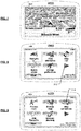
- the block diagram of the navigation device 200 is not inclusive of all components of the navigation device, but is only representative of many example components.
- the navigation device 200 is located within a housing (not shown).
- the navigation device 200 includes a processing resource comprising, for example, the processor 202 mentioned above, the processor 202 being coupled to an input device 204 and a display device, for example a display screen 206.
- a processing resource comprising, for example, the processor 202 mentioned above, the processor 202 being coupled to an input device 204 and a display device, for example a display screen 206.
- the input device 204 represents any number of input devices, including a keyboard device, voice input device, touch panel and/or any other known input device utilised to input information.
- the display screen 206 can include any type of display screen such as a Liquid Crystal Display (LCD), for example.
- LCD Liquid Crystal Display
- one aspect of the input device 204, the touch panel, and the display screen 206 are integrated so as to provide an integrated input and display device, including a touchpad or touchscreen input 250 ( Figure 4 ) to enable both input of information (via direct input, menu selection, etc.) and display of information through the touch panel screen so that a user need only touch a portion of the display screen 206 to select one of a plurality of display choices or to activate one of a plurality of virtual or "soft" buttons.
- the processor 202 supports a Graphical User Interface (GUI) that operates in conjunction with the touchscreen.
- GUI Graphical User Interface
- the processor 202 is operatively connected to memory 214 (which may comprise any combination of ROM, RAM, disk drive or solid state storage devices, and may be part of the aforementioned data storage device 170) via connection 216 and is further adapted to receive/send information from/to input/output (I/O) ports 218 via connection 220, wherein the I/O port 218 is connectible to an I/O device 222 external to the navigation device 200.
- the external I/O device 222 may include, but is not limited to an external listening device, such as an earpiece for example.
- Figure 3 further illustrates an operative connection between the processor 202 and an antenna/receiver 224 via connection 226, wherein the antenna/receiver 224 can be a GPS antenna/receiver for example.
- the antenna and receiver designated by reference numeral 224 are combined schematically for illustration, but that the antenna and receiver may be separately located components, and that the antenna may be a GPS patch antenna or helical antenna for example.
- the electronic components shown in Figure 3 are powered by one or more power sources (not shown) in a conventional manner.
- the components shown in Figure 3 may be in communication with one another via wired and/or wireless connections and the like.
- the navigation device 200 described herein can be a portable or handheld navigation device 200.
- the portable or handheld navigation device 200 of Figure 3 can be connected or "docked" in a known manner to a vehicle such as a bicycle, a motorbike, a car or a boat for example. Such a navigation device 200 is then removable from the docked location for portable or handheld navigation use.
- the navigation device 200 may be a unit that includes the integrated input and display device 206 and the other components of Figure 2 (including, but not limited to, the internal GPS receiver 224, the microprocessor 202, a power supply (not shown), memory systems 214, etc.).
- the processor 202 and memory 214 of the navigation device cooperate to support a BIOS (Basic Input/Output System) 282 that functions as an interface between functional hardware components 280 of the navigation device 200 and software executed by the device.
- BIOS Basic Input/Output System
- the processor 202 is configured to load an operating system 284 from the memory 214, and the operating system provides a processing environment in which application software 286 (implementing some or all of the route planning, navigation and other functionality described herein) can run.
- the application software 286 provides an operational environment including a GUI that supports core functions of the navigation device, for example map viewing, route planning, navigation functions and other functions associated therewith.
- the mass data storage 160 of the server 150 is configured to include a map data store 300, a correction log 302 and a route log 304.
- data storage 170 of the navigation device 200 includes a map data store 306, a user correction log 308 and a route log 310.
- the server 150 also maintains a log of those user devices that have opted in to the user feedback system.
- the map data stores 300, 306 include digital map data that is used by navigation devices, in a known manner, to provide users with the ability to navigate between locations in the map and to provide rendered maps for display to users.
- the server-side correction log 302 includes details of map correction requests submitted by users for incorporation into the digital map defined by the digital data held in the map data store 300 if it is appropriate to do so, and the server-side route log 304 includes data concerning the routes travelled by navigation device users who have subscribed to the navigation data improvement system.
- the server-side route log 304 includes, for each route store, data defining the route travelled as well as an identifier that uniquely identifies the navigation device used whilst that route was being travelled.
- the user correction log 308 comprises a database of instances where the user has indicated that a map data correction is required and the type of correction that the user believes should be made. As will be appreciated by persons skilled in the art, such a list can be compiled in a number of different ways, one of which will later be described. Depending on the type of connection between the navigation device 200 and server 150, data from the user correction log 308 can be transferred to the server 150 whilst the navigation device is still mobile, or in a particularly preferred implementation the log can be transferred to the server when the navigation device is next connected to the server for updating.
- the route log 310 comprises a database of routes travelled by the user's navigation device 200; typically only the routes travelled since the last time the navigation device was connected to the server.
- the database includes details of those routes where the device was operated to guide the user to a selected destination, and may also include details of routes travelled whist in free-driving mode.
- map data updates are provided from the server-side map data store 300 to the navigation device 200 for storage in the navigation device map data store 306, and data from the user correction log 308 and route log 310 (if any is stored) is transferred from the navigation device 200 to the server 150 for storage in the correction log 302 and route log, respectively.
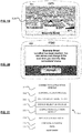
- FIGs. 7 to 18 there are shown various screenshots from a TomTomTM Go 720 navigation device which illustrate one way in which a user of a navigation device can log a correction that they believe needs to be made to the navigation data, in this instance the navigation data stored in their device
- the device is displaying a map of the area of London surrounding Bouverie Street. Touching the screen of the device causes it to display a number of options, as shown in Fig. 8 , and a continuation arrow 312. Touching the continuation arrow 312 causes the device to display, as shown in Fig. 9 , another series of options that include a virtual button 314 labelled "map corrections".
- the incorrect speed limit is associated with the road in the vicinity of the device's current location, namely Bouverie Street, London.
- Touching a virtual button 320 labelled "near you” causes the device to display a map of the local area as shown in Fig. 12 .
- the user can then select the street in the local area (in this example: Fleet Street) that requires correction of the speed limit associated with it by touching the screen and once selected, as shown in Fig. 13 , at least part of the chosen road is highlighted and the name of the road is displayed.
- selecting virtual button 324 labelled “done” causes the device to generate a display as shown in Fig. 16 which requests the user to confirm that the change is "permanent and valid for normal passenger cars" (we assume it is in this example), following which the user is advised by way of the display shown in Fig. 17 that their map has been changed and is prompted to indicate by touching the appropriate virtual button whether they wish to share this change with other TomTom users.
- the server processor is configured to invoke and execute software modules in server memory 156.
- the processor 154 and memory 156 cooperate to support a BIOS (Basic Input/Output System) 330 that functions as an interface between functional hardware components of the server 150 and software executed by the server 150.
- BIOS Basic Input/Output System
- the processor 154 is configured to load an operating system 332, for example from the memory 156, for execution in the processing environment provided by the memory 156.
- the operating system 332 provides a processing environment in which application software 334 can run.
- the device selection module 338 is configured to inspect the route log 304 and, in one configuration, select devices that have previously travelled routes which include the particular location associated with the correction selected for validation from the correction log 302 by the correction selection module 336.
- the device selection process can take a number of different forms.
- the device selection module 338 may be configured to select the first X devices from the route log that have travelled a route which includes the location associated with the selected correction (where X is a number chosen as the minimum number of user devices that must be selected for a requested correction).
- the number X may be a function of the number of devices with routes that pass the location.
- the number X may be, preferably automatically, dynamically adjusted upwards for locations that have been visited by many devices and downwards for locations that have been visited by a smaller number of devices.
- the device selection module 338 may be configured to identify a set of devices which have travelled a route that includes the location associated with the selected correction, rank the set of devices (for example by the number of times that the device concerned has travelled through the selected location), and then select a subset of X devices (where, as before, X is a number chosen (optionally dynamically) for the system) consisting of the devices that have most frequently visited the location and which are to be contacted for correction validation purposes. As before, the devices selected for inclusion in this subset may be chosen at random from a subset consisting of those devices that have most frequently visited the location in question.
- the device selection module may adjust the definition of the "vicinity" of that location upwards, perhaps to include those devices for whom routes are recorded that include locations within a given distance (for example a kilometre) of the location associated with the requested correction.
- the user request generator 340 is configured to generate, for the particular correction type included in the correction log 302, user requests that each comprise a set of instructions for transfer to each of the navigation devices selected by the device selection module 338.
- the instructions when executed by the respective processors 202 of the navigation devices 200 will cause those devices to generate and present to the user of the device a request for user assistance in the validation of a reported map data correction.
- the user requests, once generated, are stored by the server (for example in the mass data storage 160) for transfer to the navigation devices associated with each generated request on the next occasion that the device communicates with the server 150.
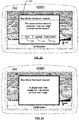
- the user may be presented with the request shortly before they enter the street in question (on the rationale that street signs are usually provided at entrances to a street).
- the user may be presented with the request only once they are actually in the street in question (on the rationale that speed limit signs are usually provided at regular intervals along a street).
- the navigation device If the user should touch the screen in the vicinity of the "YES" button, the navigation device generates a display such as that shown in Fig. 23 requesting the user, in this instance, to say the name of the road after an audio tone has been played.
- the display shown in Fig. 23 may, as before, be accompanied by a corresponding audio message to the user of the device, and a short while after the user has been notified the navigation device generates an audio tone and switches to a record mode whereby input device 204 (which in this instance includes a microphone) is activated and audio received via the input device is recorded to the memory 214 of the navigation device for transfer to the server 150 via the communications channel 152 when the navigation device is next in contact with the server 150.
- input device 204 which in this instance includes a microphone
- the user request is cleared from the display and the processor records that the user has declined to assist with this particular user request.
- the processor may then be configured to delete the request, or to notify the server 150 when the navigation device is next connected that the user has declined this particular user request.
- the server could be configured to maintain a log of declined requests and in the event that more than a given number of requests are declined by the user of a particular device, to issue instructions for transfer to the user of that device to cause the processor to indicate to the user of the device that they have declined requests for assistance on multiple occasions in the past, and provide the user with the option to remove their device from the list of devices that the server can approach for assistance with map data corrections.
- the response review module 342 may be configured to invoke speech analysis functionality to convert received audio into a computer intelligible form before received responses are compared. It is also recognised that a comparison of the received audio could be undertaken, using conventional audio analysis techniques, but it is anticipated that such an approach may prove less useful given different audio qualities of the environments in which the responses are captured and likely differences between users.
- the application software includes conventional navigation device software modules such as route planning, navigation, and map rendering modules the like of which are well known in the art and for brevity will not be described herein in detail.
- the route planning module enables a user of the device to input a start location and plan a route to an inputted destination
- the navigation module enables the device to receive GPS signals, determine the device location and generate route guidance instructions for provision to the user
- the map view rendering module is configured to generate displays of regions of the digital map, for example a region where the device is currently located as determined by the navigation module.
- the device is predominately operated in a mobile mode without a connection to the server 150, but it will be apparent to persons skilled in the art that the teachings of the present invention could equally well be implemented in a system where the location, or at least the general location, of each navigation device is known.
- the navigation device could be configured to periodically transmit its location, as determined by the navigation module from received GPS signals, to the server 150 using, for example, an integral or connected mobile communications device (such as a mobile telephone or a telephony equipped PDA).
- the device When the device connects with the server, for example when the device is next coupled to the device via an internet or immediately if the device is connected to the server whilst being operated, the device transmits the error correction request to the server.
- the server on receipt of a correction request from a device the server stores the request in the correction request store.
- the server selects a request for validation by users, selects the set of devices that are to be asked to assist with validation of the correction request, and generates a user request for transmission to the selected user devices (for example when those devices are next connected to the server). In due course the generated user requests are transmitted to the selected devices.
- the navigation device may utilise any kind of position sensing technology as an alternative to (or indeed in addition to) GPS.
- the navigation device may utilise using other global navigation satellite systems such as the European Galileo system. Equally, it is not limited to satellite based but could readily function using ground based beacons or any other kind of system that enables the device to determine its geographic location.
Landscapes
- Engineering & Computer Science (AREA)
- Remote Sensing (AREA)
- Radar, Positioning & Navigation (AREA)
- Physics & Mathematics (AREA)
- General Physics & Mathematics (AREA)
- Automation & Control Theory (AREA)
- Databases & Information Systems (AREA)
- Theoretical Computer Science (AREA)
- Data Mining & Analysis (AREA)
- General Engineering & Computer Science (AREA)
- Navigation (AREA)
Priority Applications (1)
| Application Number | Priority Date | Filing Date | Title |
|---|---|---|---|
| EP16150978.1A EP3029422B1 (en) | 2008-10-07 | 2008-10-07 | Validating map data corrections |
Applications Claiming Priority (3)
| Application Number | Priority Date | Filing Date | Title |
|---|---|---|---|
| EP16150978.1A EP3029422B1 (en) | 2008-10-07 | 2008-10-07 | Validating map data corrections |
| EP08875161.5A EP2335021B1 (en) | 2008-10-07 | 2008-10-07 | Validating map data corrections |
| PCT/EP2008/063410 WO2010040390A1 (en) | 2008-10-07 | 2008-10-07 | Validating map data corrections |
Related Parent Applications (1)
| Application Number | Title | Priority Date | Filing Date |
|---|---|---|---|
| EP08875161.5A Division EP2335021B1 (en) | 2008-10-07 | 2008-10-07 | Validating map data corrections |
Publications (2)
| Publication Number | Publication Date |
|---|---|
| EP3029422A1 EP3029422A1 (en) | 2016-06-08 |
| EP3029422B1 true EP3029422B1 (en) | 2017-12-06 |
Family
ID=40648754
Family Applications (3)
| Application Number | Title | Priority Date | Filing Date |
|---|---|---|---|
| EP16150978.1A Active EP3029422B1 (en) | 2008-10-07 | 2008-10-07 | Validating map data corrections |
| EP08875161.5A Active EP2335021B1 (en) | 2008-10-07 | 2008-10-07 | Validating map data corrections |
| EP16150977.3A Active EP3029421B1 (en) | 2008-10-07 | 2008-10-07 | Validating map data corrections |
Family Applications After (2)
| Application Number | Title | Priority Date | Filing Date |
|---|---|---|---|
| EP08875161.5A Active EP2335021B1 (en) | 2008-10-07 | 2008-10-07 | Validating map data corrections |
| EP16150977.3A Active EP3029421B1 (en) | 2008-10-07 | 2008-10-07 | Validating map data corrections |
Country Status (10)
Families Citing this family (73)
| Publication number | Priority date | Publication date | Assignee | Title |
|---|---|---|---|---|
| GB2447672B (en) | 2007-03-21 | 2011-12-14 | Ford Global Tech Llc | Vehicle manoeuvring aids |
| US9250331B2 (en) * | 2008-12-31 | 2016-02-02 | At&T Intellectual Property I, L.P. | Method and apparatus for providing mapping data |
| US9020745B2 (en) * | 2009-03-30 | 2015-04-28 | Microsoft Technology Licensing, Llc | Business data display and position correction in street-side imagery |
| US8554831B2 (en) * | 2009-06-02 | 2013-10-08 | Ford Global Technologies, Llc | System and method for executing hands-free operation of an electronic calendar application within a vehicle |
| US8346310B2 (en) * | 2010-02-05 | 2013-01-01 | Ford Global Technologies, Llc | Method and apparatus for communication between a vehicle based computing system and a remote application |
| US9094436B2 (en) | 2010-05-27 | 2015-07-28 | Ford Global Technologies, Llc | Methods and systems for interfacing with a vehicle computing system over multiple data transport channels |
| US8473575B2 (en) | 2010-08-26 | 2013-06-25 | Ford Global Technologies, Llc | Methods and apparatus for remote activation of an application |
| US10163273B2 (en) | 2010-09-28 | 2018-12-25 | Ford Global Technologies, Llc | Method and system for operating mobile applications in a vehicle |
| US8560739B2 (en) | 2010-12-28 | 2013-10-15 | Ford Global Technologies, Llc | Methods and systems for regulating operation of one or more functions of a mobile application |
| US9854209B2 (en) | 2011-04-19 | 2017-12-26 | Ford Global Technologies, Llc | Display system utilizing vehicle and trailer dynamics |
| US9290204B2 (en) | 2011-04-19 | 2016-03-22 | Ford Global Technologies, Llc | Hitch angle monitoring system and method |
| US9555832B2 (en) | 2011-04-19 | 2017-01-31 | Ford Global Technologies, Llc | Display system utilizing vehicle and trailer dynamics |
| US9926008B2 (en) | 2011-04-19 | 2018-03-27 | Ford Global Technologies, Llc | Trailer backup assist system with waypoint selection |
| US9500497B2 (en) | 2011-04-19 | 2016-11-22 | Ford Global Technologies, Llc | System and method of inputting an intended backing path |
| US9506774B2 (en) | 2011-04-19 | 2016-11-29 | Ford Global Technologies, Llc | Method of inputting a path for a vehicle and trailer |
| US9374562B2 (en) | 2011-04-19 | 2016-06-21 | Ford Global Technologies, Llc | System and method for calculating a horizontal camera to target distance |
| US9248858B2 (en) | 2011-04-19 | 2016-02-02 | Ford Global Technologies | Trailer backup assist system |
| US9969428B2 (en) | 2011-04-19 | 2018-05-15 | Ford Global Technologies, Llc | Trailer backup assist system with waypoint selection |
| US20120310445A1 (en) | 2011-06-02 | 2012-12-06 | Ford Global Technologies, Llc | Methods and Apparatus for Wireless Device Application Having Vehicle Interaction |
| KR101110639B1 (ko) | 2011-06-22 | 2012-06-12 | 팅크웨어(주) | 세이프 서비스 시스템 및 그 방법 |
| US9529752B2 (en) | 2011-07-25 | 2016-12-27 | Ford Global Technologies, Llc | Method and apparatus for communication between a vehicle based computing system and a remote application |
| US8694203B2 (en) | 2011-09-12 | 2014-04-08 | Ford Global Technologies, Llc | Method and apparatus for vehicle process emulation and configuration on a mobile platform |
| RU2014132179A (ru) * | 2012-01-05 | 2016-02-20 | Глимпс Инк. | Системы и способы интеграции мобильной связи |
| US9547872B2 (en) | 2012-02-22 | 2017-01-17 | Ebay Inc. | Systems and methods for providing search results along a corridor |
| US9171327B2 (en) | 2012-03-23 | 2015-10-27 | Ebay Inc. | Systems and methods for in-vehicle navigated shopping |
| GB201204006D0 (en) | 2012-03-07 | 2012-04-18 | Tomtom Int Bv | Point of interest database maintenance system |
| US9886794B2 (en) | 2012-06-05 | 2018-02-06 | Apple Inc. | Problem reporting in maps |
| US10156455B2 (en) | 2012-06-05 | 2018-12-18 | Apple Inc. | Context-aware voice guidance |
| US9997069B2 (en) | 2012-06-05 | 2018-06-12 | Apple Inc. | Context-aware voice guidance |
| US20130321400A1 (en) | 2012-06-05 | 2013-12-05 | Apple Inc. | 3D Map Views for 3D Maps |
| US9482296B2 (en) | 2012-06-05 | 2016-11-01 | Apple Inc. | Rendering road signs during navigation |
| US10176633B2 (en) | 2012-06-05 | 2019-01-08 | Apple Inc. | Integrated mapping and navigation application |
| US9418672B2 (en) | 2012-06-05 | 2016-08-16 | Apple Inc. | Navigation application with adaptive instruction text |
| US8965696B2 (en) | 2012-06-05 | 2015-02-24 | Apple Inc. | Providing navigation instructions while operating navigation application in background |
| GB201211626D0 (en) | 2012-06-29 | 2012-08-15 | Tomtom Dev Germany Gmbh | Location estimation method and system |
| US9078088B2 (en) | 2012-07-12 | 2015-07-07 | Myine Electronics, Inc. | System and method for transport layer agnostic programming interface for use with smartphones |
| WO2014087050A1 (en) * | 2012-12-04 | 2014-06-12 | Nokia Corporation | Method and apparatus for validating potential points of interest using user and device characteristics |
| CN103021260B (zh) * | 2012-12-14 | 2017-07-04 | 北京百度网讯科技有限公司 | 一种道路门牌数据的校验方法和装置 |
| US9218805B2 (en) | 2013-01-18 | 2015-12-22 | Ford Global Technologies, Llc | Method and apparatus for incoming audio processing |
| US8981916B2 (en) | 2013-01-28 | 2015-03-17 | Ford Global Technologies, Llc | Method and apparatus for customized vehicle sound-based location |
| US9511799B2 (en) | 2013-02-04 | 2016-12-06 | Ford Global Technologies, Llc | Object avoidance for a trailer backup assist system |
| US9592851B2 (en) | 2013-02-04 | 2017-03-14 | Ford Global Technologies, Llc | Control modes for a trailer backup assist system |
| US9538339B2 (en) | 2013-02-07 | 2017-01-03 | Ford Global Technologies, Llc | Method and system of outputting in a vehicle data streamed by mobile applications |
| US9146899B2 (en) | 2013-02-07 | 2015-09-29 | Ford Global Technologies, Llc | System and method of arbitrating audio source streamed by mobile applications |
| US9042603B2 (en) | 2013-02-25 | 2015-05-26 | Ford Global Technologies, Llc | Method and apparatus for estimating the distance from trailer axle to tongue |
| US8676431B1 (en) | 2013-03-12 | 2014-03-18 | Google Inc. | User interface for displaying object-based indications in an autonomous driving system |
| USD750663S1 (en) | 2013-03-12 | 2016-03-01 | Google Inc. | Display screen or a portion thereof with graphical user interface |
| USD754189S1 (en) * | 2013-03-13 | 2016-04-19 | Google Inc. | Display screen or portion thereof with graphical user interface |
| USD754190S1 (en) * | 2013-03-13 | 2016-04-19 | Google Inc. | Display screen or portion thereof with graphical user interface |
| US8933822B2 (en) | 2013-03-15 | 2015-01-13 | Ford Global Technologies, Llc | Method and apparatus for extra-vehicular emergency updates following an accident |
| US9479601B2 (en) | 2013-03-15 | 2016-10-25 | Ford Global Technologies, Llc | Method and apparatus for seamless application portability over multiple environments |
| US9197336B2 (en) | 2013-05-08 | 2015-11-24 | Myine Electronics, Inc. | System and method for providing customized audio content to a vehicle radio system using a smartphone |
| EP2848891B1 (en) * | 2013-09-13 | 2017-03-15 | Elektrobit Automotive GmbH | Technique for providing travel information |
| US9352777B2 (en) | 2013-10-31 | 2016-05-31 | Ford Global Technologies, Llc | Methods and systems for configuring of a trailer maneuvering system |
| US10963951B2 (en) | 2013-11-14 | 2021-03-30 | Ebay Inc. | Shopping trip planner |
| US9547989B2 (en) * | 2014-03-04 | 2017-01-17 | Google Inc. | Reporting road event data and sharing with other vehicles |
| US9233710B2 (en) | 2014-03-06 | 2016-01-12 | Ford Global Technologies, Llc | Trailer backup assist system using gesture commands and method |
| US9228841B2 (en) * | 2014-06-02 | 2016-01-05 | Xerox Corporation | Methods and systems for determining routes in a navigation system |
| US9402189B2 (en) | 2014-07-02 | 2016-07-26 | Here Global B.V. | Method and apparatus for providing activity-based map job |
| US9522677B2 (en) | 2014-12-05 | 2016-12-20 | Ford Global Technologies, Llc | Mitigation of input device failure and mode management |
| US9533683B2 (en) | 2014-12-05 | 2017-01-03 | Ford Global Technologies, Llc | Sensor failure mitigation system and mode management |
| JP2016138816A (ja) * | 2015-01-28 | 2016-08-04 | アルパイン株式会社 | ナビゲーション装置及びコンピュータプログラム |
| US9896130B2 (en) | 2015-09-11 | 2018-02-20 | Ford Global Technologies, Llc | Guidance system for a vehicle reversing a trailer along an intended backing path |
| US10371543B1 (en) | 2016-01-05 | 2019-08-06 | Open Invention Network Llc | Navigation application providing supplemental navigation information |
| US10112646B2 (en) | 2016-05-05 | 2018-10-30 | Ford Global Technologies, Llc | Turn recovery human machine interface for trailer backup assist |
| US10554783B2 (en) * | 2016-12-30 | 2020-02-04 | Lyft, Inc. | Navigation using proximity information |
| DE102017216584A1 (de) * | 2017-09-19 | 2019-03-21 | Robert Bosch Gmbh | Verfahren und Vorrichtung zum Erstellen einer Karte |
| US11475182B1 (en) | 2018-05-04 | 2022-10-18 | Apple Inc. | Simulation-based map validation |
| US11181384B2 (en) | 2018-07-23 | 2021-11-23 | Waymo Llc | Verifying map data using challenge questions |
| CN109189872B (zh) * | 2018-08-13 | 2021-06-04 | 武汉中海庭数据技术有限公司 | 高精度地图数据验证装置及方法 |
| US20200340820A1 (en) * | 2019-04-26 | 2020-10-29 | Toyota Motor North America, Inc. | Managing transport occupants during transport events |
| GB201909556D0 (en) | 2019-07-03 | 2019-08-14 | Tomtom Traffic Bv | Collecting user-contributed data relating to a navibable network |
| US11436263B2 (en) * | 2020-04-02 | 2022-09-06 | Palash Karia | Geocoding methods and systems of correcting latitude and longitude of a point of interest |
Family Cites Families (8)
| Publication number | Priority date | Publication date | Assignee | Title |
|---|---|---|---|---|
| US5764184A (en) * | 1997-03-10 | 1998-06-09 | Deere & Company | Method and system for post-processing differential global positioning system satellite positional data |
| US6487495B1 (en) * | 2000-06-02 | 2002-11-26 | Navigation Technologies Corporation | Navigation applications using related location-referenced keywords |
| US6718258B1 (en) * | 2000-06-08 | 2004-04-06 | Navigation Technologies Corp | Method and system for obtaining user feedback regarding geographic data |
| WO2006081509A2 (en) | 2005-01-26 | 2006-08-03 | Beckham James P | Zero-backlash baitcast fishing reel |
| JP4241637B2 (ja) * | 2005-02-08 | 2009-03-18 | 三菱電機株式会社 | 地図情報処理装置 |
| US20080082225A1 (en) * | 2006-08-15 | 2008-04-03 | Tomtom International B.V. | A method of reporting errors in map data used by navigation devices |
| GB2440958A (en) * | 2006-08-15 | 2008-02-20 | Tomtom Bv | Method of correcting map data for use in navigation systems |
| DE602006007151D1 (de) * | 2006-10-24 | 2009-07-16 | Abb Research Ltd | Simulation von Feldgeräten in einem computerbasierten Steuersystem |
-
2008
- 2008-10-07 EP EP16150978.1A patent/EP3029422B1/en active Active
- 2008-10-07 EP EP08875161.5A patent/EP2335021B1/en active Active
- 2008-10-07 BR BRPI0822736-5A patent/BRPI0822736A2/pt not_active IP Right Cessation
- 2008-10-07 WO PCT/EP2008/063410 patent/WO2010040390A1/en active Application Filing
- 2008-10-07 KR KR1020117007988A patent/KR20110063824A/ko not_active Withdrawn
- 2008-10-07 CN CN200880129272.4A patent/CN102037316B/zh active Active
- 2008-10-07 AU AU2008362574A patent/AU2008362574A1/en not_active Abandoned
- 2008-10-07 EP EP16150977.3A patent/EP3029421B1/en active Active
- 2008-10-07 CA CA2725559A patent/CA2725559A1/en not_active Abandoned
- 2008-10-07 JP JP2011529456A patent/JP5307897B2/ja active Active
- 2008-10-07 US US12/736,833 patent/US8543335B2/en active Active
- 2008-10-24 TW TW097141054A patent/TW201017125A/zh unknown
-
2013
- 2013-08-22 US US13/973,245 patent/US20130338916A1/en not_active Abandoned
- 2013-08-22 US US13/973,258 patent/US9057613B2/en active Active
-
2015
- 2015-05-26 US US14/722,004 patent/US9541414B2/en active Active
Non-Patent Citations (1)
| Title |
|---|
| None * |
Also Published As
| Publication number | Publication date |
|---|---|
| EP2335021B1 (en) | 2016-01-13 |
| US8543335B2 (en) | 2013-09-24 |
| US20110112762A1 (en) | 2011-05-12 |
| US20130338917A1 (en) | 2013-12-19 |
| US9057613B2 (en) | 2015-06-16 |
| EP3029421A1 (en) | 2016-06-08 |
| US20150253147A1 (en) | 2015-09-10 |
| CA2725559A1 (en) | 2010-04-15 |
| CN102037316A (zh) | 2011-04-27 |
| TW201017125A (en) | 2010-05-01 |
| EP3029422A1 (en) | 2016-06-08 |
| US9541414B2 (en) | 2017-01-10 |
| US20130338916A1 (en) | 2013-12-19 |
| JP2012505372A (ja) | 2012-03-01 |
| WO2010040390A1 (en) | 2010-04-15 |
| JP5307897B2 (ja) | 2013-10-02 |
| EP2335021A1 (en) | 2011-06-22 |
| EP3029421B1 (en) | 2017-12-06 |
| KR20110063824A (ko) | 2011-06-14 |
| CN102037316B (zh) | 2014-11-19 |
| BRPI0822736A2 (pt) | 2015-06-23 |
| AU2008362574A1 (en) | 2010-04-15 |
Similar Documents
| Publication | Publication Date | Title |
|---|---|---|
| EP3029422B1 (en) | Validating map data corrections | |
| US11112256B2 (en) | Methods and systems for providing information indicative of a recommended navigable stretch | |
| US20110125398A1 (en) | Navigation apparatus, server apparatus and method of providing point of interest data | |
| WO2009156185A1 (en) | Navigation device & method for providing parking place availability | |
| WO2010040386A1 (en) | Navigation apparatus and method of determining a route therefor | |
| WO2009036844A1 (en) | Navigation apparatus and method therefor | |
| EP2459962B1 (en) | Alert content reception apparatus, alert content communications system and method of acquiring alert content | |
| CN104764456B (zh) | 验证地图数据校正 | |
| WO2010076045A1 (en) | Timed route navigation device | |
| WO2010040384A1 (en) | Navigation apparatus having a three-dimensional display | |
| WO2010081544A1 (en) | Mapping system and method | |
| WO2010075875A1 (en) | Personal navigation device | |
| WO2010081538A2 (en) | Navigation device & method | |
| WO2009080069A1 (en) | Method and apparatus for updating a digital map | |
| WO2010040382A1 (en) | Navigation apparatus and method for use therein | |
| WO2010012295A1 (en) | Navigation apparatus and method and computer software for use in the same | |
| WO2010075876A1 (en) | Navigation system with means for indicating the lateral position | |
| WO2010081543A2 (en) | Navigation system and method | |
| TW201027035A (en) | Personal navigation system |
Legal Events
| Date | Code | Title | Description |
|---|---|---|---|
| PUAI | Public reference made under article 153(3) epc to a published international application that has entered the european phase |
Free format text: ORIGINAL CODE: 0009012 |
|
| AC | Divisional application: reference to earlier application |
Ref document number: 2335021 Country of ref document: EP Kind code of ref document: P |
|
| AK | Designated contracting states |
Kind code of ref document: A1 Designated state(s): AT BE BG CH CY CZ DE DK EE ES FI FR GB GR HR HU IE IS IT LI LT LU LV MC MT NL NO PL PT RO SE SI SK TR |
|
| 17P | Request for examination filed |
Effective date: 20161205 |
|
| RBV | Designated contracting states (corrected) |
Designated state(s): AT BE BG CH CY CZ DE DK EE ES FI FR GB GR HR HU IE IS IT LI LT LU LV MC MT NL NO PL PT RO SE SI SK TR |
|
| GRAP | Despatch of communication of intention to grant a patent |
Free format text: ORIGINAL CODE: EPIDOSNIGR1 |
|
| INTG | Intention to grant announced |
Effective date: 20170612 |
|
| GRAS | Grant fee paid |
Free format text: ORIGINAL CODE: EPIDOSNIGR3 |
|
| GRAA | (expected) grant |
Free format text: ORIGINAL CODE: 0009210 |
|
| AC | Divisional application: reference to earlier application |
Ref document number: 2335021 Country of ref document: EP Kind code of ref document: P |
|
| AK | Designated contracting states |
Kind code of ref document: B1 Designated state(s): AT BE BG CH CY CZ DE DK EE ES FI FR GB GR HR HU IE IS IT LI LT LU LV MC MT NL NO PL PT RO SE SI SK TR |
|
| REG | Reference to a national code |
Ref country code: GB Ref legal event code: FG4D |
|
| REG | Reference to a national code |
Ref country code: AT Ref legal event code: REF Ref document number: 952787 Country of ref document: AT Kind code of ref document: T Effective date: 20171215 Ref country code: CH Ref legal event code: EP |
|
| REG | Reference to a national code |
Ref country code: IE Ref legal event code: FG4D |
|
| REG | Reference to a national code |
Ref country code: DE Ref legal event code: R096 Ref document number: 602008053309 Country of ref document: DE |
|
| REG | Reference to a national code |
Ref country code: NL Ref legal event code: FP |
|
| REG | Reference to a national code |
Ref country code: LT Ref legal event code: MG4D |
|
| PG25 | Lapsed in a contracting state [announced via postgrant information from national office to epo] |
Ref country code: NO Free format text: LAPSE BECAUSE OF FAILURE TO SUBMIT A TRANSLATION OF THE DESCRIPTION OR TO PAY THE FEE WITHIN THE PRESCRIBED TIME-LIMIT Effective date: 20180306 Ref country code: ES Free format text: LAPSE BECAUSE OF FAILURE TO SUBMIT A TRANSLATION OF THE DESCRIPTION OR TO PAY THE FEE WITHIN THE PRESCRIBED TIME-LIMIT Effective date: 20171206 Ref country code: FI Free format text: LAPSE BECAUSE OF FAILURE TO SUBMIT A TRANSLATION OF THE DESCRIPTION OR TO PAY THE FEE WITHIN THE PRESCRIBED TIME-LIMIT Effective date: 20171206 Ref country code: LT Free format text: LAPSE BECAUSE OF FAILURE TO SUBMIT A TRANSLATION OF THE DESCRIPTION OR TO PAY THE FEE WITHIN THE PRESCRIBED TIME-LIMIT Effective date: 20171206 Ref country code: SE Free format text: LAPSE BECAUSE OF FAILURE TO SUBMIT A TRANSLATION OF THE DESCRIPTION OR TO PAY THE FEE WITHIN THE PRESCRIBED TIME-LIMIT Effective date: 20171206 |
|
| REG | Reference to a national code |
Ref country code: AT Ref legal event code: MK05 Ref document number: 952787 Country of ref document: AT Kind code of ref document: T Effective date: 20171206 |
|
| PG25 | Lapsed in a contracting state [announced via postgrant information from national office to epo] |
Ref country code: BG Free format text: LAPSE BECAUSE OF FAILURE TO SUBMIT A TRANSLATION OF THE DESCRIPTION OR TO PAY THE FEE WITHIN THE PRESCRIBED TIME-LIMIT Effective date: 20180306 Ref country code: GR Free format text: LAPSE BECAUSE OF FAILURE TO SUBMIT A TRANSLATION OF THE DESCRIPTION OR TO PAY THE FEE WITHIN THE PRESCRIBED TIME-LIMIT Effective date: 20180307 Ref country code: HR Free format text: LAPSE BECAUSE OF FAILURE TO SUBMIT A TRANSLATION OF THE DESCRIPTION OR TO PAY THE FEE WITHIN THE PRESCRIBED TIME-LIMIT Effective date: 20171206 Ref country code: LV Free format text: LAPSE BECAUSE OF FAILURE TO SUBMIT A TRANSLATION OF THE DESCRIPTION OR TO PAY THE FEE WITHIN THE PRESCRIBED TIME-LIMIT Effective date: 20171206 |
|
| PG25 | Lapsed in a contracting state [announced via postgrant information from national office to epo] |
Ref country code: CZ Free format text: LAPSE BECAUSE OF FAILURE TO SUBMIT A TRANSLATION OF THE DESCRIPTION OR TO PAY THE FEE WITHIN THE PRESCRIBED TIME-LIMIT Effective date: 20171206 Ref country code: SK Free format text: LAPSE BECAUSE OF FAILURE TO SUBMIT A TRANSLATION OF THE DESCRIPTION OR TO PAY THE FEE WITHIN THE PRESCRIBED TIME-LIMIT Effective date: 20171206 Ref country code: EE Free format text: LAPSE BECAUSE OF FAILURE TO SUBMIT A TRANSLATION OF THE DESCRIPTION OR TO PAY THE FEE WITHIN THE PRESCRIBED TIME-LIMIT Effective date: 20171206 |
|
| PG25 | Lapsed in a contracting state [announced via postgrant information from national office to epo] |
Ref country code: RO Free format text: LAPSE BECAUSE OF FAILURE TO SUBMIT A TRANSLATION OF THE DESCRIPTION OR TO PAY THE FEE WITHIN THE PRESCRIBED TIME-LIMIT Effective date: 20171206 Ref country code: IT Free format text: LAPSE BECAUSE OF FAILURE TO SUBMIT A TRANSLATION OF THE DESCRIPTION OR TO PAY THE FEE WITHIN THE PRESCRIBED TIME-LIMIT Effective date: 20171206 Ref country code: AT Free format text: LAPSE BECAUSE OF FAILURE TO SUBMIT A TRANSLATION OF THE DESCRIPTION OR TO PAY THE FEE WITHIN THE PRESCRIBED TIME-LIMIT Effective date: 20171206 Ref country code: PL Free format text: LAPSE BECAUSE OF FAILURE TO SUBMIT A TRANSLATION OF THE DESCRIPTION OR TO PAY THE FEE WITHIN THE PRESCRIBED TIME-LIMIT Effective date: 20171206 |
|
| REG | Reference to a national code |
Ref country code: DE Ref legal event code: R097 Ref document number: 602008053309 Country of ref document: DE |
|
| REG | Reference to a national code |
Ref country code: FR Ref legal event code: PLFP Year of fee payment: 11 |
|
| PLBE | No opposition filed within time limit |
Free format text: ORIGINAL CODE: 0009261 |
|
| STAA | Information on the status of an ep patent application or granted ep patent |
Free format text: STATUS: NO OPPOSITION FILED WITHIN TIME LIMIT |
|
| 26N | No opposition filed |
Effective date: 20180907 |
|
| PG25 | Lapsed in a contracting state [announced via postgrant information from national office to epo] |
Ref country code: SI Free format text: LAPSE BECAUSE OF FAILURE TO SUBMIT A TRANSLATION OF THE DESCRIPTION OR TO PAY THE FEE WITHIN THE PRESCRIBED TIME-LIMIT Effective date: 20171206 Ref country code: DK Free format text: LAPSE BECAUSE OF FAILURE TO SUBMIT A TRANSLATION OF THE DESCRIPTION OR TO PAY THE FEE WITHIN THE PRESCRIBED TIME-LIMIT Effective date: 20171206 |
|
| REG | Reference to a national code |
Ref country code: CH Ref legal event code: PL |
|
| REG | Reference to a national code |
Ref country code: BE Ref legal event code: MM Effective date: 20181031 |
|
| PG25 | Lapsed in a contracting state [announced via postgrant information from national office to epo] |
Ref country code: LU Free format text: LAPSE BECAUSE OF NON-PAYMENT OF DUE FEES Effective date: 20181007 Ref country code: MC Free format text: LAPSE BECAUSE OF FAILURE TO SUBMIT A TRANSLATION OF THE DESCRIPTION OR TO PAY THE FEE WITHIN THE PRESCRIBED TIME-LIMIT Effective date: 20171206 |
|
| REG | Reference to a national code |
Ref country code: IE Ref legal event code: MM4A |
|
| PG25 | Lapsed in a contracting state [announced via postgrant information from national office to epo] |
Ref country code: LI Free format text: LAPSE BECAUSE OF NON-PAYMENT OF DUE FEES Effective date: 20181031 Ref country code: BE Free format text: LAPSE BECAUSE OF NON-PAYMENT OF DUE FEES Effective date: 20181031 Ref country code: CH Free format text: LAPSE BECAUSE OF NON-PAYMENT OF DUE FEES Effective date: 20181031 |
|
| PG25 | Lapsed in a contracting state [announced via postgrant information from national office to epo] |
Ref country code: IE Free format text: LAPSE BECAUSE OF NON-PAYMENT OF DUE FEES Effective date: 20181007 |
|
| PG25 | Lapsed in a contracting state [announced via postgrant information from national office to epo] |
Ref country code: MT Free format text: LAPSE BECAUSE OF NON-PAYMENT OF DUE FEES Effective date: 20181007 |
|
| PG25 | Lapsed in a contracting state [announced via postgrant information from national office to epo] |
Ref country code: TR Free format text: LAPSE BECAUSE OF FAILURE TO SUBMIT A TRANSLATION OF THE DESCRIPTION OR TO PAY THE FEE WITHIN THE PRESCRIBED TIME-LIMIT Effective date: 20171206 |
|
| PG25 | Lapsed in a contracting state [announced via postgrant information from national office to epo] |
Ref country code: PT Free format text: LAPSE BECAUSE OF FAILURE TO SUBMIT A TRANSLATION OF THE DESCRIPTION OR TO PAY THE FEE WITHIN THE PRESCRIBED TIME-LIMIT Effective date: 20171206 |
|
| PG25 | Lapsed in a contracting state [announced via postgrant information from national office to epo] |
Ref country code: HU Free format text: LAPSE BECAUSE OF FAILURE TO SUBMIT A TRANSLATION OF THE DESCRIPTION OR TO PAY THE FEE WITHIN THE PRESCRIBED TIME-LIMIT; INVALID AB INITIO Effective date: 20081007 Ref country code: CY Free format text: LAPSE BECAUSE OF FAILURE TO SUBMIT A TRANSLATION OF THE DESCRIPTION OR TO PAY THE FEE WITHIN THE PRESCRIBED TIME-LIMIT Effective date: 20171206 |
|
| PG25 | Lapsed in a contracting state [announced via postgrant information from national office to epo] |
Ref country code: IS Free format text: LAPSE BECAUSE OF FAILURE TO SUBMIT A TRANSLATION OF THE DESCRIPTION OR TO PAY THE FEE WITHIN THE PRESCRIBED TIME-LIMIT Effective date: 20180406 |
|
| P01 | Opt-out of the competence of the unified patent court (upc) registered |
Effective date: 20230520 |
|
| PGFP | Annual fee paid to national office [announced via postgrant information from national office to epo] |
Ref country code: GB Payment date: 20240906 Year of fee payment: 17 |
|
| PGFP | Annual fee paid to national office [announced via postgrant information from national office to epo] |
Ref country code: FR Payment date: 20240923 Year of fee payment: 17 |
|
| PGFP | Annual fee paid to national office [announced via postgrant information from national office to epo] |
Ref country code: NL Payment date: 20240917 Year of fee payment: 17 |
|
| PGFP | Annual fee paid to national office [announced via postgrant information from national office to epo] |
Ref country code: DE Payment date: 20240904 Year of fee payment: 17 |