EP3020634A1 - Deployable airborne sensor array system and method of use - Google Patents
Deployable airborne sensor array system and method of use Download PDFInfo
- Publication number
- EP3020634A1 EP3020634A1 EP15194150.7A EP15194150A EP3020634A1 EP 3020634 A1 EP3020634 A1 EP 3020634A1 EP 15194150 A EP15194150 A EP 15194150A EP 3020634 A1 EP3020634 A1 EP 3020634A1
- Authority
- EP
- European Patent Office
- Prior art keywords
- target
- image
- airborne
- computing device
- tether
- Prior art date
- Legal status (The legal status is an assumption and is not a legal conclusion. Google has not performed a legal analysis and makes no representation as to the accuracy of the status listed.)
- Granted
Links
- 238000000034 method Methods 0.000 title claims abstract description 65
- 230000008569 process Effects 0.000 claims abstract description 18
- 238000003384 imaging method Methods 0.000 claims description 37
- 238000012545 processing Methods 0.000 claims description 6
- 230000008878 coupling Effects 0.000 claims description 4
- 238000010168 coupling process Methods 0.000 claims description 4
- 238000005859 coupling reaction Methods 0.000 claims description 4
- 238000004891 communication Methods 0.000 description 13
- 238000010586 diagram Methods 0.000 description 12
- 238000004519 manufacturing process Methods 0.000 description 10
- 230000006870 function Effects 0.000 description 6
- 230000007246 mechanism Effects 0.000 description 4
- 230000000694 effects Effects 0.000 description 3
- 238000005516 engineering process Methods 0.000 description 2
- 238000012423 maintenance Methods 0.000 description 2
- 238000007726 management method Methods 0.000 description 2
- 230000004048 modification Effects 0.000 description 2
- 238000012986 modification Methods 0.000 description 2
- 230000003287 optical effect Effects 0.000 description 2
- 239000002245 particle Substances 0.000 description 2
- 230000003068 static effect Effects 0.000 description 2
- 230000005540 biological transmission Effects 0.000 description 1
- 239000004020 conductor Substances 0.000 description 1
- 238000013500 data storage Methods 0.000 description 1
- 238000013461 design Methods 0.000 description 1
- 230000007613 environmental effect Effects 0.000 description 1
- 230000010354 integration Effects 0.000 description 1
- 239000000463 material Substances 0.000 description 1
- 230000008520 organization Effects 0.000 description 1
- 230000000737 periodic effect Effects 0.000 description 1
- 238000009419 refurbishment Methods 0.000 description 1
- 230000004044 response Effects 0.000 description 1
- 230000007723 transport mechanism Effects 0.000 description 1
- 230000000007 visual effect Effects 0.000 description 1
Images


Classifications
-
- B—PERFORMING OPERATIONS; TRANSPORTING
- B64—AIRCRAFT; AVIATION; COSMONAUTICS
- B64D—EQUIPMENT FOR FITTING IN OR TO AIRCRAFT; FLIGHT SUITS; PARACHUTES; ARRANGEMENTS OR MOUNTING OF POWER PLANTS OR PROPULSION TRANSMISSIONS IN AIRCRAFT
- B64D3/00—Aircraft adaptations to facilitate towing or being towed
-
- G—PHYSICS
- G05—CONTROLLING; REGULATING
- G05D—SYSTEMS FOR CONTROLLING OR REGULATING NON-ELECTRIC VARIABLES
- G05D1/00—Control of position, course or altitude of land, water, air, or space vehicles, e.g. automatic pilot
- G05D1/10—Simultaneous control of position or course in three dimensions
- G05D1/101—Simultaneous control of position or course in three dimensions specially adapted for aircraft
- G05D1/104—Simultaneous control of position or course in three dimensions specially adapted for aircraft involving a plurality of aircrafts, e.g. formation flying
-
- G—PHYSICS
- G01—MEASURING; TESTING
- G01D—MEASURING NOT SPECIALLY ADAPTED FOR A SPECIFIC VARIABLE; ARRANGEMENTS FOR MEASURING TWO OR MORE VARIABLES NOT COVERED IN A SINGLE OTHER SUBCLASS; TARIFF METERING APPARATUS; MEASURING OR TESTING NOT OTHERWISE PROVIDED FOR
- G01D21/00—Measuring or testing not otherwise provided for
- G01D21/02—Measuring two or more variables by means not covered by a single other subclass
-
- G—PHYSICS
- G06—COMPUTING; CALCULATING OR COUNTING
- G06T—IMAGE DATA PROCESSING OR GENERATION, IN GENERAL
- G06T3/00—Geometric image transformation in the plane of the image
- G06T3/40—Scaling the whole image or part thereof
- G06T3/4053—Super resolution, i.e. output image resolution higher than sensor resolution
-
- B—PERFORMING OPERATIONS; TRANSPORTING
- B64—AIRCRAFT; AVIATION; COSMONAUTICS
- B64C—AEROPLANES; HELICOPTERS
- B64C39/00—Aircraft not otherwise provided for
- B64C39/02—Aircraft not otherwise provided for characterised by special use
- B64C39/022—Tethered aircraft
-
- B—PERFORMING OPERATIONS; TRANSPORTING
- B64—AIRCRAFT; AVIATION; COSMONAUTICS
- B64D—EQUIPMENT FOR FITTING IN OR TO AIRCRAFT; FLIGHT SUITS; PARACHUTES; ARRANGEMENTS OR MOUNTING OF POWER PLANTS OR PROPULSION TRANSMISSIONS IN AIRCRAFT
- B64D47/00—Equipment not otherwise provided for
- B64D47/08—Arrangements of cameras
-
- B—PERFORMING OPERATIONS; TRANSPORTING
- B64—AIRCRAFT; AVIATION; COSMONAUTICS
- B64U—UNMANNED AERIAL VEHICLES [UAV]; EQUIPMENT THEREFOR
- B64U10/00—Type of UAV
- B64U10/60—Tethered aircraft
-
- G—PHYSICS
- G01—MEASURING; TESTING
- G01C—MEASURING DISTANCES, LEVELS OR BEARINGS; SURVEYING; NAVIGATION; GYROSCOPIC INSTRUMENTS; PHOTOGRAMMETRY OR VIDEOGRAMMETRY
- G01C21/00—Navigation; Navigational instruments not provided for in groups G01C1/00 - G01C19/00
- G01C21/20—Instruments for performing navigational calculations
-
- G—PHYSICS
- G01—MEASURING; TESTING
- G01C—MEASURING DISTANCES, LEVELS OR BEARINGS; SURVEYING; NAVIGATION; GYROSCOPIC INSTRUMENTS; PHOTOGRAMMETRY OR VIDEOGRAMMETRY
- G01C23/00—Combined instruments indicating more than one navigational value, e.g. for aircraft; Combined measuring devices for measuring two or more variables of movement, e.g. distance, speed or acceleration
- G01C23/005—Flight directors
-
- H—ELECTRICITY
- H01—ELECTRIC ELEMENTS
- H01Q—ANTENNAS, i.e. RADIO AERIALS
- H01Q1/00—Details of, or arrangements associated with, antennas
- H01Q1/27—Adaptation for use in or on movable bodies
- H01Q1/28—Adaptation for use in or on aircraft, missiles, satellites, or balloons
-
- B—PERFORMING OPERATIONS; TRANSPORTING
- B64—AIRCRAFT; AVIATION; COSMONAUTICS
- B64U—UNMANNED AERIAL VEHICLES [UAV]; EQUIPMENT THEREFOR
- B64U2101/00—UAVs specially adapted for particular uses or applications
- B64U2101/30—UAVs specially adapted for particular uses or applications for imaging, photography or videography
-
- B—PERFORMING OPERATIONS; TRANSPORTING
- B64—AIRCRAFT; AVIATION; COSMONAUTICS
- B64U—UNMANNED AERIAL VEHICLES [UAV]; EQUIPMENT THEREFOR
- B64U2201/00—UAVs characterised by their flight controls
- B64U2201/20—Remote controls
- B64U2201/202—Remote controls using tethers for connecting to ground station
-
- G—PHYSICS
- G06—COMPUTING; CALCULATING OR COUNTING
- G06T—IMAGE DATA PROCESSING OR GENERATION, IN GENERAL
- G06T2207/00—Indexing scheme for image analysis or image enhancement
- G06T2207/10—Image acquisition modality
- G06T2207/10004—Still image; Photographic image
- G06T2207/10012—Stereo images
-
- G—PHYSICS
- G06—COMPUTING; CALCULATING OR COUNTING
- G06T—IMAGE DATA PROCESSING OR GENERATION, IN GENERAL
- G06T2207/00—Indexing scheme for image analysis or image enhancement
- G06T2207/10—Image acquisition modality
- G06T2207/10032—Satellite or aerial image; Remote sensing
- G06T2207/10044—Radar image
-
- G—PHYSICS
- G06—COMPUTING; CALCULATING OR COUNTING
- G06T—IMAGE DATA PROCESSING OR GENERATION, IN GENERAL
- G06T2207/00—Indexing scheme for image analysis or image enhancement
- G06T2207/30—Subject of image; Context of image processing
- G06T2207/30212—Military
-
- G—PHYSICS
- G06—COMPUTING; CALCULATING OR COUNTING
- G06T—IMAGE DATA PROCESSING OR GENERATION, IN GENERAL
- G06T2207/00—Indexing scheme for image analysis or image enhancement
- G06T2207/30—Subject of image; Context of image processing
- G06T2207/30232—Surveillance
Definitions
- This invention relates generally to airborne sensors, and more particularly, to a deployable airborne sensor array system and method of use.
- At least some known air surveillance and reconnaissance systems use an aerial vehicle coupled to a tether.
- the tether restricts the flight space, so that a fly-away will not occur.
- the aerial vehicle may include a sensor for surveillance or other data gathering relating to a target.
- Some systems typically include only a single sensor on a single aerial vehicle, which limits the amount of data that can be gathered.
- Other known systems include a plurality of aerial vehicles tethered to a ground station. Such systems may be limited in their range of operation and ability to position the aerial vehicles relative to one another.
- a deployable airborne sensor array system in one aspect, includes a tether configured to be coupled to and deployed from an aircraft and a plurality of airborne vehicles coupled to the tether. Each of the plurality of airborne vehicles includes different lift characteristics to form a three-dimensional (3D) array of airborne vehicles. Each airborne vehicle includes a sensing device configured to generate sensor data associated with a target. The system also include a computing device configured to process the sensor data received from each of said plurality of airborne vehicles and generate an image of the target based on the sensor data.
- a method in another aspect, includes deploying a tether from an aircraft, the tether including a plurality of airborne vehicles coupled to the tether. Each of the plurality of airborne vehicles includes different lift characteristics to form a three-dimensional (3D) array of airborne vehicles. Each airborne vehicle includes a sensing device configured to generate sensor data associated with a target. The method also includes processing, by a computing device, sensor data associated with a target received from each of the plurality of airborne vehicles. The sensor data is generated by a sensing device coupled to each airborne vehicle. The method further includes generating, by the computing device, an image of the target based on the sensor data.
- the method further comprises the step of generating a 3D image of the target using 3D ray tracing methodology, the 3D image generated based on the position of each of the imaging cameras relative to the target.
- the method further comprises instructing the imaging cameras to capture a two-dimensional (2D) image of the target at varying times, and interleaving the captured 2D images based on the time in which each 2D image was captured to generate a high-speed video of the target.
- the method further comprises the steps of instructing each of the sensing devices to transmit a radio frequency pulse signal toward the target, receiving a radio frequency pulse return signal from each of the sensing devices, and combining the received radio frequency pulse return signals to generate a 3D image of the target having increased azimuth resolution.
- deploying a tether further comprises deploying a tether including a plurality of airborne vehicles having different horizontal and vertical lift characteristics relative to one another, such that the plurality of airborne vehicles establish a three-dimensional array of sensors operating coherently to capture a three-dimensional view of a target at an instant in time.
- FIG. 1 is a block diagram of an exemplary deployable airborne sensor array system 100.
- system 100 includes an airborne mother ship 102 configured to deploy and tow one or more airborne vehicles 104 coupled to a flexible tether 106.
- System 100 also includes a computing device 108 in communication with each airborne vehicle 104.
- tether 106 includes a first end 110 coupled to airborne mother ship 102, and a second end 112 extending outward behind airborne mother ship 102.
- Mother ship 102 includes a tether management system (not shown) or other securing means for retaining and controlling the amount of tether released.
- the tether management system may be, for example, a winch or any other mechanical device that is capable of pulling in, letting out, or otherwise adjusting the tension/length of tether 106.
- each airborne vehicle 104 includes a sensor device 114 configured to generate sensor data associated with a target object (not shown).
- Sensor device 114 may include, for example, a surveillance imaging camera, one or more microphones, thermometers, hygrometers, barometers, anemometers, pyranometers, or any other sensor that enables system 100 to function as described herein.
- the sensor data collected by airborne vehicle 104 via sensor devices 114 is transmitted in real time to computing device 108.
- the sensor data may also be transmitted to an end user for viewing or to a computer-implemented database where the sensor data may be stored.
- the end user may be located at, for example, airborne mother ship 102, a ground station (not shown), or at a remote location where access is provided via a network (e.g., the Internet).
- the sensor data transmission may be wireless or wired. When a wired communication link is employed, it may be accomplished via conductors embedded in tether 106.
- Computing device 108 may be located at, for example, airborne mother ship 102, a ground station (not shown), or at a remote location where access is provided via a network (e.g., the Internet).
- Computing device 108 is configured to receive and process the sensor data received from airborne vehicles 104, and generate an image of the target object based on the sensor data, as described in more detail herein.
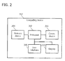
- FIG. 2 is a block diagram of an example computing device 200 that may generate an image of a target object.
- computing device 200 is similar to computing device 108 (shown in FIG. 1 ).
- Computing device 200 may include a bus 202, a processor 204, a main memory 206, a read only memory (ROM) 208, a storage device 210, an input device 212, an output device 214, and a communication interface 216.
- Bus 202 may include a path that permits communication among the components of computing device 200.
- Processor 204 may include any type of conventional processor, microprocessor, or processing logic that interprets and executes instructions.
- Main memory 206 may include a random access memory (RAM) or another type of dynamic storage device that stores information and instructions for execution by processor 204.
- ROM 208 may include a conventional ROM device or another type of static storage device that stores static information and instructions for use by processor 204.
- Storage device 210 may include a magnetic and/or optical recording medium and its corresponding drive. In some implementations, storage device 210 includes wind data received from one or more airborne vehicles 104.
- Input device 212 may include a conventional mechanism that permits computing device 200 to receive commands, instructions, or other inputs from a user, including visual, audio, touch, button presses, stylus taps, etc. Additionally, input device may receive location information. Accordingly, input device 212 may include, for example, a camera, a microphone, one or more buttons, a mouse, and/or a touch screen.
- Output device 214 may include a conventional mechanism that outputs information to a user, including a display (including a touch screen) and/or a speaker.
- Communication interface 216 may include any transceiver-like mechanism that enables computing device 200 to communicate with other devices and/or systems. For example, communication interface 216 may include mechanisms for communicating with one or more airborne vehicles 104, sensor devices 114, and/or another computing device.
- computing device 200 facilitates generating an image of the target object based on the sensor data received from sensor devices 114.
- Computing device 200 may perform these and other operations in response to processor 204 executing software instructions contained in a computer-readable medium, such as memory 206.
- a computer-readable medium may be defined as a physical or logical memory device and/or carrier wave.
- the software instructions may be read into memory 206 from another computer-readable medium, such as data storage device 210, or from another device via communication interface 216.
- the software instructions contained in memory 206 may cause processor 204 to perform processes described herein.
- hardwired circuitry may be used in place of or in combination with software instructions to implement processes consistent with the subject matter herein. Thus, implementations consistent with the principles of the subject matter disclosed herein are not limited to any specific combination of hardware circuitry and software.
- FIG. 3 is an illustration of an exemplary implementation of airborne vehicle 104 (shown in FIG. 1 ).
- airborne vehicle 104 is an unmanned aerial vehicle (UAV); however, airborne vehicle 104 may be any type of airborne sensor vehicle that enables system 100 to function as described herein.
- Airborne vehicle 104 includes a nose portion 300, a body portion 302, a tail portion 304, and wings 306 coupled to body portion 302.
- Sensor device 114 is coupled to a bottom portion 308 of airborne vehicle 104 to provide sensor device 114 with an unobstructed line-of-sight towards the target object.
- each of wings 306 and/or tail portion 304 includes an elevator 310 that facilitates adjusting vertical lift of airborne vehicle 104.
- positioning elevator 310 horizontally would cause airborne vehicle 104 to fly substantially directly behind mother ship 102.
- Biasing elevator 310 downward relative to a horizontal axis would generate lift on airborne vehicle 104, causing it to fly at a higher elevation than mother ship 102.
- Biasing elevator 310 upward relative to the horizontal axis would generate a downward force on airborne vehicle 104, causing it to fly at a lower elevation than mother ship 102.
- the angle of elevators 310 of the plurality of airborne vehicles 104 may be biased at different angles relative to the horizontal axis so that sensor devices 114 can collect sensor data from varying perspectives relative to the target object.
- tail portion 304 includes a rudder 312 that facilitates adjusting horizontal lift of airborne vehicle 104.
- biasing rudder 312 straight behind airborne vehicle 104 relative to direction of flight would cause airborne vehicle 104 to fly substantially directly behind mother ship 102.
- biasing rudder 312 towards the left relative to a vertical axis would generate lift causing airborne vehicle 104 to fly to the right of mother ship 102.
- biasing rudder 312 towards the right relative to the vertical axis would generate lift causing airborne vehicle 104 to fly to the left of mother ship 102.
- the angles of elevators 310 of the plurality of airborne vehicles 104 may be biased at different angles relative to the vertical axis to provide varying perspectives of the target object.
- airborne vehicle 104 includes a propulsion system (not shown) configured to provide thrust to control flight of airborne vehicle 104.
- the propulsion system may be any type of propulsion system known in the art for providing thrust on an airborne vehicle.
- FIG. 4 is a block diagram of an exemplary deployable sensor array 400.
- each airborne vehicle 104 is designed to have different lift characteristics such that the positions of airborne vehicles 104 relative to mother ship 102 and to each other are known.
- different lift characteristics include unbalanced wings 306 on at least first and second airborne vehicles 402 and 404 that cause them to glide to the left and to the right of mother ship 102, respectively.
- Different lift characteristics further include a positive lift profile and negative lift profile on at least third and fourth airborne vehicles 406 and 408 that cause them to glide above and below the aircraft, respectively.
- the different lift characteristics cause the plurality of airborne vehicles 104 to establish a three-dimensional array of sensors operating coherently to capture a three-dimensional view of a target at an instant in time.
- FIG. 5 is a block diagram of an exemplary deployable sensor array 500.
- array 500 includes a first airborne vehicle 502 coupled to a first tether 504. Coupled to first airborne vehicle 502 are a second tether 506, a third tether 508, a fourth tether 510, and a fifth tether 512.
- a second airborne vehicle 514 and a third airborne vehicle 516 are coupled to second tether 506.
- a fourth airborne vehicle 518 and a fifth airborne vehicle 520 are coupled to third tether 508.
- a sixth airborne vehicle 522 and a seventh airborne vehicle 524 are coupled to fourth tether 510.
- An eighth airborne vehicle 526 and a ninth airborne vehicle 528 are coupled to fifth tether 512.
- Second, third, fourth, and fifth tethers 506, 508, 510, and 512 converge and are coupled to a tenth airborne vehicle 530.
- the dotted lines are merely provided to illustrate that airborne vehicles 104 are in a 3D configuration.
- Second and third airborne vehicles 514 and 516 are configured to glide above and to the right of mother ship 102.
- Fourth and fifth airborne vehicles 518 and 520 are configured to glide above and to the left of mother ship 102.
- Sixth and seventh airborne vehicles 522 and 524 are configured to glide below and to the right of mother ship 102.
- Eighth and ninth airborne vehicles 526 and 528 are configured to glide below and to the left of mother ship 102.
- airborne vehicles 104 may be positioned in any configuration that enables deployable sensor array system 100 to function as described herein.
- FIG. 6 is a flow chart of a process 600 that may be performed by computing device 200 (shown in FIG. 2 ) for generating a super-resolution image of a target.
- processor 204 of computing device 200 aims 602 the plurality of sensor devices 114 at the target.
- the target may be selected by computing device 200 or may be input into computing device 200 by a user.
- Processor 204 then instructs 604 sensor devices 114 to capture a two-dimensional (2D) image of the target.
- Each sensor device 114 transmits the 2D images to computing device 200 as sensor data.
- Communication interface 216 of computing device 200 receives 606 the sensor data from sensor devices 114.
- computing device 200 determines 608 a position of each sensor device 114 relative to the target.
- a position of each sensor device 114 relative to mother ship 102 is known, so using a global positioning system or other position measuring device, a position of mother ship 102 relative to the target may be determined. Using geometry, the position of each sensor device 114 relative to the target may then be determined.
- Computing device 200 determines 610 an effective pixel size for each sensor device 114 based on the position of each sensor device 114 relative to the target. Finally, computing device 200 generates 612 a super-resolution image of the target using the determined effective pixel size for each sensor device 114.
- FIG. 7 is a flow chart of a process 700 that may be performed by computing device 200 (shown in FIG. 2 ) for generating a three-dimensional (3D) image of a target.
- processor 204 of computing device 200 aims 702 the plurality of sensor devices 114 at the target.
- the target may be selected by computing device 200 or may be input into computing device 200 by a user.
- Processor 204 then instructs 704 sensor devices 114 to capture a two-dimensional (2D) image of the target.
- Each sensor device 114 transmits the 2D images to computing device 200 as sensor data.
- Communication interface 216 of computing device 200 receives 706 the sensor data from sensor devices 114.
- computing device 200 determines 708 a position of each sensor device 114 relative to the target.
- a position of each sensor device 114 relative to mother ship 102 is known, so using a global positioning system or other position measuring device, a position of mother ship 102 relative to the target may be determined. Using geometry, the position of each sensor device 114 relative to the target may then be determined.
- computing device 200 generates 710 a 3D image of the target using 3D ray tracing methodology.
- the 3D image is generated based on the position of each sensor device 114 relative to the target.
- FIG. 8 is a flow chart of a process 800 that may be performed by computing device 200 (shown in FIG. 2 ) for generating a high-speed video of a target.
- processor 204 of computing device 200 aims 802 the plurality of sensor devices 114 at the target.
- the target may be selected by computing device 200 or may be input into computing device 200 by a user.
- Processor 204 then instructs 804 sensor devices 114 to capture a two-dimensional (2D) image of the target at varying times. The varying times may be specified by a user or pre-programmed into computing device 200.
- Each sensor device 114 transmits the 2D images to computing device 200 as sensor data.
- Communication interface 216 of computing device 200 receives 806 the sensor data from sensor devices 114.
- Computing device 200 then interleaves 808 the captured 2D images based on the time in which each 2D image was captured to generate a high-speed video of the target.
- FIG. 9 is a flow chart of a process 900 that may be performed by computing device 200 (shown in FIG. 2 ) for generating a 3D image of a target having increased azimuth resolution.
- processor 204 of computing device 200 instructs 902 a transmitter 314 (shown in FIGs. 1 and 3 ) on mother ship 102 or on a sensor device 114 to transmit a radio frequency (RF) pulse signal toward the target.
- sensor devices 114 include radio receivers. Each sensor device 114 receives an RF pulse return signal, which is transmitted to computing device 200.
- Communication device 216 of computing device 200 receives 904 the radio frequency pulse return signal from each sensor device 114.
- Computing device 200 then combines 906 the received radio frequency pulse return signals to generate a 3D image of the target having increased azimuth resolution.
- the RF pulse is detected by a specific sensor device 114 after an amount of time determined by the path length from RF pulse transmitter 314 to any reflecting object and then from the reflecting object to the specific sensor device 114. Returns from everywhere with the same total path length from transmitter 314 to the specific sensor device 114 arrive at the same time. Because the sensor device 114 is moving relative to the scene, the Doppler shift will indicate the azimuth from which the components of the signal are returning. The intensity of the returns detected by specific sensor device 114, as a function of frequency and time of return, provide the data to develop a two-dimensional radar image. Another sensor device 114 has a different set of positions that have equal path lengths from transmitter 314 to the receiver with different Doppler shifts.
- computing device 200 can generate a full 3D image via radar.
- the combined return signals together with the 3D image via radar may be used to determine a vector of incoming radio wavelength signal.
- the intensity return of an object changes with direction of the reflection, so detectors in different directions may be used to map out and produce better identification of the objects in the scene.
- FIG. 10 is a flow diagram of an exemplary aircraft production and service methodology.
- FIG. 11 is a block diagram of an exemplary aircraft. Implementations of the disclosure may be described in the context of an aircraft manufacturing and service method 1000 (shown in FIG. 10 ) and via an aircraft 1002 (shown in FIG. 11 ).
- pre-production including specification and design 1004 data of aircraft 1002 may be used during the manufacturing process and other materials associated with the airframe may be procured 1006.
- component and subassembly manufacturing 1008 and system integration 1010 of the aircraft 1002 occurs, prior to aircraft 1002 entering its certification and delivery process 1012.
- aircraft 1002 may be placed in service 1014. While in service by a customer, aircraft 1002 is scheduled for periodic, routine, and scheduled maintenance and service 1016, including any modification, reconfiguration, and/or refurbishment, for example.
- Each portion and process associated with aircraft manufacturing and/or service 1000 may be performed or completed by a system integrator, a third party, and/or an operator (e.g., a customer).
- a system integrator may include without limitation any number of aircraft manufacturers and major-system subcontractors
- a third party may include without limitation any number of venders, subcontractors, and suppliers
- an operator may be an airline, leasing company, military entity, service organization, and so on.
- an aircraft 1002 produced via method 1000 may include an airframe 1018 having a plurality of systems 1020 and an interior 1022.
- high-level systems 1020 include one or more of a propulsion system 1024, an electrical system 1026, a hydraulic system 1028, and/or an environmental system 1030. Any number of other systems may be included.
- Systems and methods embodied herein may be employed during any one or more of the stages of method 1000.
- components or subassemblies corresponding to component production process 1008 may be fabricated or manufactured in a manner similar to components or subassemblies produced while aircraft 1002 is in service.
- one or more system implementations, method implementations, or a combination thereof may be utilized during the production stages 1008 and 1010, for example, by substantially expediting assembly of, and/or reducing the cost of assembly of aircraft 1002.
- one or more of system implementations, method implementations, or a combination thereof may be utilized while aircraft 1002 is being serviced or maintained, for example, during scheduled maintenance and service 1016.
- An exemplary technical effect of the methods and systems described herein includes at least one of: (a) deploying a tether from an aircraft, the tether including a plurality of airborne vehicles coupled to the tether, each of the plurality of airborne vehicles having different lift characteristics to form a three-dimensional (3D) array of airborne vehicles; each airborne vehicle including a sensing device configured to generate sensor data associated with a target; (b) processing, by a computing device, sensor data associated with a target received from each of the plurality of airborne vehicles, the sensor data generated by a sensing device coupled to each airborne vehicle; and (c) generating, by the computing device, an image of the target based on the sensor data.
- the implementations described herein provide a deployable sensor array system for generating an image of a target.
- the array includes a plurality of airborne vehicles that have different lift characteristics such that they form a 3D array.
- Each airborne vehicle includes a sensor device for collecting sensor data relating to the target. Because the sensor devices are formed into a 3D array, the sensor data may be formed into multiple types of images.
- the sensor array system may be launched and recovered from a single mother ship.
- a general purpose processor e.g., microprocessor, conventional processor, controller, microcontroller, state machine or combination of computing devices
- DSP digital signal processor
- ASIC application specific integrated circuit
- FPGA field programmable gate array
- steps of a method or process described herein may be embodied directly in hardware, in a software module executed by a processor, or in a combination of the two.
- a software module may reside in RAM memory, flash memory, ROM memory, EPROM memory, EEPROM memory, registers, hard disk, a removable disk, a CD-ROM, or any other form of storage medium known in the art.
- a controller, computing device, or computer such as described herein, including the on and off-board BPL modems, may include at least one or more processors or processing units and a system memory.
- the controller typically also includes at least some form of computer readable media.
- computer readable media may include computer storage media and communication media.
- Computer storage media may include volatile and nonvolatile, removable and non-removable media implemented in any method or technology that enables storage of information, such as computer readable instructions, data structures, program modules, or other data.
- Communication media typically embody computer readable instructions, data structures, program modules, or other data in a modulated data signal such as a carrier wave or other transport mechanism and include any information delivery media.
- modulated data signal such as a carrier wave or other transport mechanism and include any information delivery media.
Abstract
Description
- This invention relates generally to airborne sensors, and more particularly, to a deployable airborne sensor array system and method of use.
- At least some known air surveillance and reconnaissance systems use an aerial vehicle coupled to a tether. The tether restricts the flight space, so that a fly-away will not occur. The aerial vehicle may include a sensor for surveillance or other data gathering relating to a target. Some systems typically include only a single sensor on a single aerial vehicle, which limits the amount of data that can be gathered. Other known systems include a plurality of aerial vehicles tethered to a ground station. Such systems may be limited in their range of operation and ability to position the aerial vehicles relative to one another.
- In one aspect, a deployable airborne sensor array system is provided. The system includes a tether configured to be coupled to and deployed from an aircraft and a plurality of airborne vehicles coupled to the tether. Each of the plurality of airborne vehicles includes different lift characteristics to form a three-dimensional (3D) array of airborne vehicles. Each airborne vehicle includes a sensing device configured to generate sensor data associated with a target. The system also include a computing device configured to process the sensor data received from each of said plurality of airborne vehicles and generate an image of the target based on the sensor data.
- In another aspect, a method is provided. The method includes deploying a tether from an aircraft, the tether including a plurality of airborne vehicles coupled to the tether. Each of the plurality of airborne vehicles includes different lift characteristics to form a three-dimensional (3D) array of airborne vehicles. Each airborne vehicle includes a sensing device configured to generate sensor data associated with a target. The method also includes processing, by a computing device, sensor data associated with a target received from each of the plurality of airborne vehicles. The sensor data is generated by a sensing device coupled to each airborne vehicle. The method further includes generating, by the computing device, an image of the target based on the sensor data. Preferably, the method further comprises the step of generating a 3D image of the target using 3D ray tracing methodology, the 3D image generated based on the position of each of the imaging cameras relative to the target. Preferably, the method further comprises instructing the imaging cameras to capture a two-dimensional (2D) image of the target at varying times, and interleaving the captured 2D images based on the time in which each 2D image was captured to generate a high-speed video of the target. Advantageously, the method further comprises the steps of instructing each of the sensing devices to transmit a radio frequency pulse signal toward the target, receiving a radio frequency pulse return signal from each of the sensing devices, and combining the received radio frequency pulse return signals to generate a 3D image of the target having increased azimuth resolution. Advantageously, in the method step of deploying a tether, deploying a tether further comprises deploying a tether including a plurality of airborne vehicles having different horizontal and vertical lift characteristics relative to one another, such that the plurality of airborne vehicles establish a three-dimensional array of sensors operating coherently to capture a three-dimensional view of a target at an instant in time.
- The features, functions, and advantages that have been discussed can be achieved independently in various implementations or may be combined in yet other implementations further details of which can be seen with reference to the following description and drawings.
-
-
FIG. 1 is a block diagram of an exemplary deployable airborne sensor array system. -
FIG. 2 is a block diagram of an example computing device that may that may generate an image of a target object. -
FIG. 3 is an illustration of an exemplary implementation of the airborne vehicle shown inFIG. 1 . -
FIG. 4 is a block diagram of an exemplary deployable sensor array. -
FIG. 5 is a block diagram of an exemplary deployable sensor array. -
FIG. 6 is a flow chart of a process that may be performed by the computing device shown inFIG. 2 for generating a super-resolution image of a target. -
FIG. 7 is a flow chart of a process that may be performed by the computing device shown inFIG. 2 for generating a three-dimensional (3D) image of a target. -
FIG. 8 is a flow chart of a process that may be performed by the computing device shown inFIG. 2 for generating a high-speed video of a target. -
FIG. 9 is a flow chart of a process that may be performed by the computing device shown inFIG. 2 for generating a 3D image of a target having increased azimuth resolution. -
FIG. 10 is a flow diagram of an exemplary aircraft production and service methodology. -
FIG. 11 is a block diagram of an exemplary aircraft. -
FIG. 1 is a block diagram of an exemplary deployable airbornesensor array system 100. In the exemplary implementation,system 100 includes anairborne mother ship 102 configured to deploy and tow one or moreairborne vehicles 104 coupled to aflexible tether 106.System 100 also includes acomputing device 108 in communication with eachairborne vehicle 104. - In the exemplary implementation,
tether 106 includes afirst end 110 coupled toairborne mother ship 102, and asecond end 112 extending outward behindairborne mother ship 102.Mother ship 102 includes a tether management system (not shown) or other securing means for retaining and controlling the amount of tether released. The tether management system may be, for example, a winch or any other mechanical device that is capable of pulling in, letting out, or otherwise adjusting the tension/length oftether 106. - In the exemplary implementation, each
airborne vehicle 104 includes asensor device 114 configured to generate sensor data associated with a target object (not shown).Sensor device 114 may include, for example, a surveillance imaging camera, one or more microphones, thermometers, hygrometers, barometers, anemometers, pyranometers, or any other sensor that enablessystem 100 to function as described herein. The sensor data collected byairborne vehicle 104 viasensor devices 114 is transmitted in real time to computingdevice 108. The sensor data may also be transmitted to an end user for viewing or to a computer-implemented database where the sensor data may be stored. The end user may be located at, for example,airborne mother ship 102, a ground station (not shown), or at a remote location where access is provided via a network (e.g., the Internet). The sensor data transmission may be wireless or wired. When a wired communication link is employed, it may be accomplished via conductors embedded intether 106. - In the exemplary implementation,
Computing device 108 may be located at, for example,airborne mother ship 102, a ground station (not shown), or at a remote location where access is provided via a network (e.g., the Internet).Computing device 108 is configured to receive and process the sensor data received fromairborne vehicles 104, and generate an image of the target object based on the sensor data, as described in more detail herein. -
FIG. 2 is a block diagram of an example computing device 200 that may generate an image of a target object. In the exemplary implementation, computing device 200 is similar to computing device 108 (shown inFIG. 1 ). Computing device 200 may include abus 202, aprocessor 204, amain memory 206, a read only memory (ROM) 208, astorage device 210, an input device 212, an output device 214, and a communication interface 216.Bus 202 may include a path that permits communication among the components of computing device 200. -
Processor 204 may include any type of conventional processor, microprocessor, or processing logic that interprets and executes instructions.Main memory 206 may include a random access memory (RAM) or another type of dynamic storage device that stores information and instructions for execution byprocessor 204.ROM 208 may include a conventional ROM device or another type of static storage device that stores static information and instructions for use byprocessor 204.Storage device 210 may include a magnetic and/or optical recording medium and its corresponding drive. In some implementations,storage device 210 includes wind data received from one or moreairborne vehicles 104. - Input device 212 may include a conventional mechanism that permits computing device 200 to receive commands, instructions, or other inputs from a user, including visual, audio, touch, button presses, stylus taps, etc. Additionally, input device may receive location information. Accordingly, input device 212 may include, for example, a camera, a microphone, one or more buttons, a mouse, and/or a touch screen. Output device 214 may include a conventional mechanism that outputs information to a user, including a display (including a touch screen) and/or a speaker. Communication interface 216 may include any transceiver-like mechanism that enables computing device 200 to communicate with other devices and/or systems. For example, communication interface 216 may include mechanisms for communicating with one or more
airborne vehicles 104,sensor devices 114, and/or another computing device. - As described herein, computing device 200 facilitates generating an image of the target object based on the sensor data received from
sensor devices 114. Computing device 200 may perform these and other operations in response toprocessor 204 executing software instructions contained in a computer-readable medium, such asmemory 206. A computer-readable medium may be defined as a physical or logical memory device and/or carrier wave. The software instructions may be read intomemory 206 from another computer-readable medium, such asdata storage device 210, or from another device via communication interface 216. The software instructions contained inmemory 206 may causeprocessor 204 to perform processes described herein. In other implementations, hardwired circuitry may be used in place of or in combination with software instructions to implement processes consistent with the subject matter herein. Thus, implementations consistent with the principles of the subject matter disclosed herein are not limited to any specific combination of hardware circuitry and software. -
FIG. 3 is an illustration of an exemplary implementation of airborne vehicle 104 (shown inFIG. 1 ). In the exemplary implementation,airborne vehicle 104 is an unmanned aerial vehicle (UAV); however,airborne vehicle 104 may be any type of airborne sensor vehicle that enablessystem 100 to function as described herein.Airborne vehicle 104 includes anose portion 300, abody portion 302, atail portion 304, andwings 306 coupled tobody portion 302.Sensor device 114 is coupled to abottom portion 308 ofairborne vehicle 104 to providesensor device 114 with an unobstructed line-of-sight towards the target object. - In the exemplary implementation, each of
wings 306 and/ortail portion 304 includes anelevator 310 that facilitates adjusting vertical lift ofairborne vehicle 104. For example,positioning elevator 310 horizontally would causeairborne vehicle 104 to fly substantially directly behindmother ship 102.Biasing elevator 310 downward relative to a horizontal axis would generate lift onairborne vehicle 104, causing it to fly at a higher elevation thanmother ship 102.Biasing elevator 310 upward relative to the horizontal axis would generate a downward force onairborne vehicle 104, causing it to fly at a lower elevation thanmother ship 102. The angle ofelevators 310 of the plurality ofairborne vehicles 104 may be biased at different angles relative to the horizontal axis so thatsensor devices 114 can collect sensor data from varying perspectives relative to the target object. - In the exemplary implementation,
tail portion 304 includes arudder 312 that facilitates adjusting horizontal lift ofairborne vehicle 104. For example, biasingrudder 312 straight behindairborne vehicle 104 relative to direction of flight would causeairborne vehicle 104 to fly substantially directly behindmother ship 102. From the perspective ofairborne vehicle 104 looking towardsmother ship 102, biasingrudder 312 towards the left relative to a vertical axis would generate lift causingairborne vehicle 104 to fly to the right ofmother ship 102. Alternatively, biasingrudder 312 towards the right relative to the vertical axis would generate lift causingairborne vehicle 104 to fly to the left ofmother ship 102. The angles ofelevators 310 of the plurality ofairborne vehicles 104 may be biased at different angles relative to the vertical axis to provide varying perspectives of the target object. - In an alternative implementation,
airborne vehicle 104 includes a propulsion system (not shown) configured to provide thrust to control flight ofairborne vehicle 104. The propulsion system may be any type of propulsion system known in the art for providing thrust on an airborne vehicle. -
FIG. 4 is a block diagram of an exemplary deployable sensor array 400. In the exemplary implementation, eachairborne vehicle 104 is designed to have different lift characteristics such that the positions ofairborne vehicles 104 relative tomother ship 102 and to each other are known. For example, different lift characteristics includeunbalanced wings 306 on at least first and secondairborne vehicles mother ship 102, respectively. Different lift characteristics further include a positive lift profile and negative lift profile on at least third and fourthairborne vehicles airborne vehicles 104 to establish a three-dimensional array of sensors operating coherently to capture a three-dimensional view of a target at an instant in time. -
FIG. 5 is a block diagram of an exemplarydeployable sensor array 500. In the exemplary implementation,array 500 includes a firstairborne vehicle 502 coupled to afirst tether 504. Coupled to firstairborne vehicle 502 are asecond tether 506, athird tether 508, afourth tether 510, and afifth tether 512. A secondairborne vehicle 514 and a thirdairborne vehicle 516 are coupled tosecond tether 506. A fourthairborne vehicle 518 and a fifthairborne vehicle 520 are coupled tothird tether 508. A sixthairborne vehicle 522 and a seventhairborne vehicle 524 are coupled tofourth tether 510. An eighthairborne vehicle 526 and a ninthairborne vehicle 528 are coupled tofifth tether 512. Second, third, fourth, andfifth tethers airborne vehicle 530. The dotted lines are merely provided to illustrate thatairborne vehicles 104 are in a 3D configuration. Second and thirdairborne vehicles mother ship 102. Fourth and fifthairborne vehicles mother ship 102. Sixth and seventhairborne vehicles mother ship 102. Eighth and ninthairborne vehicles mother ship 102. Alternatively,airborne vehicles 104 may be positioned in any configuration that enables deployablesensor array system 100 to function as described herein. -
FIG. 6 is a flow chart of aprocess 600 that may be performed by computing device 200 (shown inFIG. 2 ) for generating a super-resolution image of a target. Initially,processor 204 of computing device 200 aims 602 the plurality ofsensor devices 114 at the target. The target may be selected by computing device 200 or may be input into computing device 200 by a user.Processor 204 then instructs 604sensor devices 114 to capture a two-dimensional (2D) image of the target. Eachsensor device 114 transmits the 2D images to computing device 200 as sensor data. Communication interface 216 of computing device 200 receives 606 the sensor data fromsensor devices 114. - In the exemplary implementation, computing device 200 determines 608 a position of each
sensor device 114 relative to the target. A position of eachsensor device 114 relative tomother ship 102 is known, so using a global positioning system or other position measuring device, a position ofmother ship 102 relative to the target may be determined. Using geometry, the position of eachsensor device 114 relative to the target may then be determined. - Computing device 200 then determines 610 an effective pixel size for each
sensor device 114 based on the position of eachsensor device 114 relative to the target. Finally, computing device 200 generates 612 a super-resolution image of the target using the determined effective pixel size for eachsensor device 114. -
FIG. 7 is a flow chart of aprocess 700 that may be performed by computing device 200 (shown inFIG. 2 ) for generating a three-dimensional (3D) image of a target. Initially,processor 204 of computing device 200 aims 702 the plurality ofsensor devices 114 at the target. The target may be selected by computing device 200 or may be input into computing device 200 by a user.Processor 204 then instructs 704sensor devices 114 to capture a two-dimensional (2D) image of the target. Eachsensor device 114 transmits the 2D images to computing device 200 as sensor data. Communication interface 216 of computing device 200 receives 706 the sensor data fromsensor devices 114. - In the exemplary implementation, computing device 200 determines 708 a position of each
sensor device 114 relative to the target. A position of eachsensor device 114 relative tomother ship 102 is known, so using a global positioning system or other position measuring device, a position ofmother ship 102 relative to the target may be determined. Using geometry, the position of eachsensor device 114 relative to the target may then be determined. - In the exemplary implementation, computing device 200 generates 710 a 3D image of the target using 3D ray tracing methodology. The 3D image is generated based on the position of each
sensor device 114 relative to the target. -
FIG. 8 is a flow chart of aprocess 800 that may be performed by computing device 200 (shown inFIG. 2 ) for generating a high-speed video of a target. Initially,processor 204 of computing device 200 aims 802 the plurality ofsensor devices 114 at the target. The target may be selected by computing device 200 or may be input into computing device 200 by a user.Processor 204 then instructs 804sensor devices 114 to capture a two-dimensional (2D) image of the target at varying times. The varying times may be specified by a user or pre-programmed into computing device 200. Eachsensor device 114 transmits the 2D images to computing device 200 as sensor data. Communication interface 216 of computing device 200 receives 806 the sensor data fromsensor devices 114. Computing device 200 then interleaves 808 the captured 2D images based on the time in which each 2D image was captured to generate a high-speed video of the target. -
FIG. 9 is a flow chart of aprocess 900 that may be performed by computing device 200 (shown inFIG. 2 ) for generating a 3D image of a target having increased azimuth resolution. Initially,processor 204 of computing device 200 instructs 902 a transmitter 314 (shown inFIGs. 1 and3 ) onmother ship 102 or on asensor device 114 to transmit a radio frequency (RF) pulse signal toward the target. In the exemplary implementation,sensor devices 114 include radio receivers. Eachsensor device 114 receives an RF pulse return signal, which is transmitted to computing device 200. Communication device 216 of computing device 200 receives 904 the radio frequency pulse return signal from eachsensor device 114. Computing device 200 then combines 906 the received radio frequency pulse return signals to generate a 3D image of the target having increased azimuth resolution. - The RF pulse is detected by a
specific sensor device 114 after an amount of time determined by the path length fromRF pulse transmitter 314 to any reflecting object and then from the reflecting object to thespecific sensor device 114. Returns from everywhere with the same total path length fromtransmitter 314 to thespecific sensor device 114 arrive at the same time. Because thesensor device 114 is moving relative to the scene, the Doppler shift will indicate the azimuth from which the components of the signal are returning. The intensity of the returns detected byspecific sensor device 114, as a function of frequency and time of return, provide the data to develop a two-dimensional radar image. Anothersensor device 114 has a different set of positions that have equal path lengths fromtransmitter 314 to the receiver with different Doppler shifts. Combining these leads to higher azimuth and range resolution than provided by the Doppler effect or other known methods. Whensensor devices 114 are also at different altitudes (elevation angles), computing device 200 can generate a full 3D image via radar. The combined return signals together with the 3D image via radar may be used to determine a vector of incoming radio wavelength signal. The intensity return of an object changes with direction of the reflection, so detectors in different directions may be used to map out and produce better identification of the objects in the scene. -
FIG. 10 is a flow diagram of an exemplary aircraft production and service methodology.FIG. 11 is a block diagram of an exemplary aircraft. Implementations of the disclosure may be described in the context of an aircraft manufacturing and service method 1000 (shown inFIG. 10 ) and via an aircraft 1002 (shown inFIG. 11 ). During pre-production, including specification anddesign 1004 data ofaircraft 1002 may be used during the manufacturing process and other materials associated with the airframe may be procured 1006. During production, component andsubassembly manufacturing 1008 andsystem integration 1010 of theaircraft 1002 occurs, prior toaircraft 1002 entering its certification anddelivery process 1012. Upon successful satisfaction and completion of airframe certification,aircraft 1002 may be placed inservice 1014. While in service by a customer,aircraft 1002 is scheduled for periodic, routine, and scheduled maintenance andservice 1016, including any modification, reconfiguration, and/or refurbishment, for example. - Each portion and process associated with aircraft manufacturing and/or
service 1000 may be performed or completed by a system integrator, a third party, and/or an operator (e.g., a customer). For the purposes of this description, a system integrator may include without limitation any number of aircraft manufacturers and major-system subcontractors; a third party may include without limitation any number of venders, subcontractors, and suppliers; and an operator may be an airline, leasing company, military entity, service organization, and so on. - As shown in
FIG. 11 , anaircraft 1002 produced viamethod 1000 may include anairframe 1018 having a plurality ofsystems 1020 and an interior 1022. Examples of high-level systems 1020 include one or more of apropulsion system 1024, anelectrical system 1026, ahydraulic system 1028, and/or anenvironmental system 1030. Any number of other systems may be included. Although an aircraft example is shown, the principles of the invention may be applied to non-aviation industries, such as the automotive industry. - Systems and methods embodied herein may be employed during any one or more of the stages of
method 1000. For example, components or subassemblies corresponding tocomponent production process 1008 may be fabricated or manufactured in a manner similar to components or subassemblies produced whileaircraft 1002 is in service. Also, one or more system implementations, method implementations, or a combination thereof may be utilized during theproduction stages aircraft 1002. Similarly, one or more of system implementations, method implementations, or a combination thereof may be utilized whileaircraft 1002 is being serviced or maintained, for example, during scheduled maintenance andservice 1016. - The methods and systems described herein provide a technical effect of enabling a user to be presented with more detailed and accurate data relating to a target. An exemplary technical effect of the methods and systems described herein includes at least one of: (a) deploying a tether from an aircraft, the tether including a plurality of airborne vehicles coupled to the tether, each of the plurality of airborne vehicles having different lift characteristics to form a three-dimensional (3D) array of airborne vehicles; each airborne vehicle including a sensing device configured to generate sensor data associated with a target; (b) processing, by a computing device, sensor data associated with a target received from each of the plurality of airborne vehicles, the sensor data generated by a sensing device coupled to each airborne vehicle; and (c) generating, by the computing device, an image of the target based on the sensor data.
- The implementations described herein provide a deployable sensor array system for generating an image of a target. The array includes a plurality of airborne vehicles that have different lift characteristics such that they form a 3D array. Each airborne vehicle includes a sensor device for collecting sensor data relating to the target. Because the sensor devices are formed into a 3D array, the sensor data may be formed into multiple types of images. Moreover, the sensor array system may be launched and recovered from a single mother ship.
- It will be understood by those of skill in the art that information and signals may be represented using any of a variety of different technologies and techniques (e.g., data, instructions, commands, information, signals, bits, symbols, and chirps may be represented by voltages, currents, electromagnetic waves, magnetic fields or particles, optical fields or particles, or any combination thereof). Likewise, the various illustrative logical blocks, modules, circuits, and algorithm steps described herein may be implemented as electronic hardware, computer software, or combinations of both, depending on the application and functionality. Moreover, the various logical blocks, modules, and circuits described herein may be implemented or performed with a general purpose processor (e.g., microprocessor, conventional processor, controller, microcontroller, state machine or combination of computing devices), a digital signal processor ("DSP"), an application specific integrated circuit ("ASIC"), a field programmable gate array ("FPGA") or other programmable logic device, discrete gate or transistor logic, discrete hardware components, or any combination thereof designed to perform the functions described herein. Similarly, steps of a method or process described herein may be embodied directly in hardware, in a software module executed by a processor, or in a combination of the two. A software module may reside in RAM memory, flash memory, ROM memory, EPROM memory, EEPROM memory, registers, hard disk, a removable disk, a CD-ROM, or any other form of storage medium known in the art. Although preferred implementations of the present disclosure have been described in detail, it will be understood by those skilled in the art that various modifications can be made therein without departing from the scope of the disclosure as set forth in the appended claims.
- A controller, computing device, or computer, such as described herein, including the on and off-board BPL modems, may include at least one or more processors or processing units and a system memory. The controller typically also includes at least some form of computer readable media. By way of example and not limitation, computer readable media may include computer storage media and communication media. Computer storage media may include volatile and nonvolatile, removable and non-removable media implemented in any method or technology that enables storage of information, such as computer readable instructions, data structures, program modules, or other data. Communication media typically embody computer readable instructions, data structures, program modules, or other data in a modulated data signal such as a carrier wave or other transport mechanism and include any information delivery media. Those skilled in the art should be familiar with the modulated data signal, which has one or more of its characteristics set or changed in such a manner as to encode information in the signal. Combinations of any of the above are also included within the scope of computer readable media.
- This written description uses examples to disclose various implementations, which include the best mode, to enable any person skilled in the art to practice those implementations, including making and using any devices or systems and performing any incorporated methods. The patentable scope is defined by the claims, and may include other examples that occur to those skilled in the art. Such other examples are intended to be within the scope of the claims if they have structural elements that do not differ from the literal language of the claims, or if they include equivalent structural elements with insubstantial differences from the literal languages of the claims.
The following is non-exhaustive a list of embodiments of the invention which may or may not be claimed. - 1. A deployable airborne sensor array system comprising:
- a tether configured to be coupled to and deployed from an aircraft;
- a plurality of airborne vehicles coupled to said tether, each of said plurality of airborne vehicles having different lift characteristics to form a three-dimensional (3D) array of airborne vehicles, each airborne vehicle comprising a sensor device configured to generate sensor data associated with a target; and
- a computing device configured to:
- process the sensor data received from each of said plurality of airborne vehicles; and
- generate an image of the target based on the sensor data.
- 2. The system of Embodiment 1, wherein said tether comprises a tether network having a plurality of tethers coupling together one or more of said plurality of airborne vehicles.
- 3. The system of Embodiment 1, wherein said different lift characteristics include unbalanced wings on at least first and second airborne vehicles that cause the first and second airborne vehicles to respectively glide to the left and to the right of the aircraft, and further include a positive lift profile and negative lift profile on at least third and fourth airborne vehicles that cause the third and fourth airborne vehicles to respectively glide above and below the aircraft, such that the plurality of airborne vehicles establish a three-dimensional array of sensors operating coherently to capture a three-dimensional view of a target at an instant in time.
- 4. The system of Embodiment 3, wherein each sensor device comprises an imaging camera and said computing device is further configured to:
- aim the plurality of imaging cameras at the target; and
- instruct the imaging cameras to capture a two-dimensional (2D) image of the target.
- 5. The system of
Embodiment 4, wherein said computing device is further configured to determine a position of each of the imaging cameras relative to the target. - 6. The system of Embodiment 5, wherein said computing device is further configured to:
- determine an effective pixel size for each imaging camera based on the position of each of the imaging cameras relative to the target; and
- generate a super-resolution image of the target using the effective pixel size for each imaging camera.
- 7. The system of Embodiment 5, wherein said computing device is further configured to generate a 3D image of the target using 3D ray tracing methodology, the 3D image generated based on the position of each of the imaging cameras relative to the target.
- 8. The system of
Embodiment 4, wherein said computing device is further configured to:- instruct the imaging cameras to capture a two-dimensional (2D) image of the target at varying times; and
- interleave the captured 2D images based on the time in which each 2D image was captured to generate a high-speed video of the target.
- 9. The system of Embodiment 1, wherein said computing device is further configured to:
- instruct each of the sensor devices to transmit a radio frequency pulse signal toward the target;
- receive a radio frequency pulse return signal from each of the sensor devices; and
- combine the received radio frequency pulse return signals to generate an image of the target having increased azimuth and range resolution.
- 10. The system of Embodiment 9, wherein the image is a 3D image.
- 11. A method comprising:
- deploying a tether from an aircraft, the tether including a plurality of airborne vehicles coupled to the tether, each of the plurality of airborne vehicles having different lift characteristics to form a three-dimensional (3D) array of airborne vehicles; each airborne vehicle including a sensing device configured to generate sensor data associated with a target; and
- processing, by a computing device, sensor data associated with a target received from each of the plurality of airborne vehicles, the sensor data generated by a sensing device coupled to each airborne vehicle; and
- generating, by the computing device, an image of the target based on the sensor data.
- 12. The method of Embodiment 11, wherein deploying a tether further comprises deploying a tether network including a plurality of tethers coupling together one or more of the plurality of airborne vehicles.
- 13. The method of Embodiment 11, wherein each sensor device includes an imaging camera, said method further comprising:
- aiming the plurality of imaging cameras at the target; and
- instructing the imaging cameras to capture a two-dimensional (2D) image of the target.
- 14. The method of Embodiment 13, further comprising determining a position of each of the imaging cameras relative to the target.
- 15. The method of Embodiment 14, further comprising:
- determining an effective pixel size for each imaging camera based on the position of each of the imaging cameras relative to the target; and
- generating a super-resolution image of the target using the effective pixel size for each imaging camera.
- 16. The method of Embodiment 14, further comprising generating a 3D image of the target using 3D ray tracing methodology, the 3D image generated based on the position of each of the imaging cameras relative to the target.
- 17. The method of Embodiment 13, further comprising:
- instructing the imaging cameras to capture a two-dimensional (2D) image of the target at varying times; and
- interleaving the captured 2D images based on the time in which each 2D image was captured to generate a high-speed video of the target.
- 18. The method of Embodiment 11, further comprising:
- instructing each of the sensing devices to transmit a radio frequency pulse signal toward the target;
- receiving a radio frequency pulse return signal from each of the sensing devices; and
- combining the received radio frequency pulse return signals to generate a 3D image of the target having increased azimuth resolution.
- 19. The method of Embodiment 11, wherein deploying a tether further comprises deploying a tether including a plurality of airborne vehicles having different horizontal and vertical lift characteristics relative to one another, such that the plurality of airborne vehicles establish a three-dimensional array of sensors operating coherently to capture a three-dimensional view of a target at an instant in time.
Claims (15)
- A deployable airborne sensor array system comprising:a tether (106) configured to be coupled to and deployed from an aircraft (102);a plurality of airborne vehicles (104) coupled to said tether, each of said plurality of airborne vehicles (104) having different lift characteristics to form a three-dimensional (3D) array of airborne vehicles (104), each airborne vehicle comprising a sensor device (114)configured to generate sensor data associated with a target; anda computing device (200) configured to:process the sensor data received from each of said plurality of airborne vehicles (104); andgenerate an image of the target based on the sensor data.
- The system of Claim 1, wherein said tether (106) comprises a tether network having a plurality of tethers coupling together one or more of said plurality of airborne vehicles (104).
- The system of Claim 1 or Claim 2, wherein said different lift characteristics include unbalanced wings (306) on at least first and second airborne vehicles (402, 404) that cause the first and second airborne vehicles (402, 404) to respectively glide to the left and to the right of the aircraft (102), and further include a positive lift profile and negative lift profile on at least third and fourth airborne vehicles (406, 408) that cause the third and fourth airborne vehicles (406, 408) to respectively glide above and below the aircraft (102), such that the plurality of airborne vehicles (402, 404, 406, 408) establish a three-dimensional array of sensors (114) operating coherently to capture a three-dimensional view of a target at an instant in time.
- The system of any preceding Claim, wherein each sensor device (114) comprises an imaging camera and said computing device (200) is further configured to:aim the plurality of imaging cameras at the target; andinstruct the imaging cameras to capture a two-dimensional (2D) image of the target.
- The system of Claim 4, wherein said computing device (200) is further configured to determine a position of each of the imaging cameras relative to the target.
- The system of Claim 5, wherein said computing device (200) is further configured to:determine an effective pixel size for each imaging camera based on the position of each of the imaging cameras relative to the target; andgenerate a super-resolution image of the target using the effective pixel size for each imaging camera.
- The system of Claim 5, wherein said computing device (200) is further configured to generate a 3D image of the target using 3D ray tracing methodology, the 3D image generated based on the position of each of the imaging cameras relative to the target.
- The system of Claim 4, wherein said computing device (200) is further configured to:instruct the imaging cameras to capture a two-dimensional (2D) image of the target at varying times; andinterleave the captured 2D images based on the time in which each 2D image was captured to generate a high-speed video of the target.
- The system of Claim 1, wherein said computing device (200) is further configured to:instruct each of the sensor devices (114) to transmit a radio frequency pulse signal toward the target;receive a radio frequency pulse return signal from each of the sensor devices (114); andcombine the received radio frequency pulse return signals to generate an image of the target having increased azimuth and range resolution.
- The system of Claim 9, wherein the image is a 3D image.
- A method comprising:deploying a tether (106) from an aircraft(102), the tether (106) including a plurality of airborne vehicles (104) coupled to the tether (106), each of the plurality of airborne vehicles (104) having different lift characteristics to form a three-dimensional (3D) array of airborne vehicles (104); each airborne vehicle (104) including a sensing device (114) configured to generate sensor data associated with a target; andprocessing, by a computing device (200), sensor data associated with a target received from each of the plurality of airborne vehicles (104), the sensor data generated by a sensing device (114) coupled to each airborne vehicle (104); andgenerating, by the computing device (200), an image of the target based on the sensor data.
- The method of Claim 11, wherein deploying a tether (106) further comprises deploying a tether network including a plurality of tethers coupling together one or more of the plurality of airborne vehicles (104).
- The method of Claim 11, wherein each sensor device (114) includes an imaging camera, said method further comprising:aiming the plurality of imaging cameras at the target; andinstructing the imaging cameras to capture a two-dimensional (2D) image of the target.
- The method of Claim 13, further comprising determining a position of each of the imaging cameras relative to the target.
- The method of Claim 14, further comprising:determining an effective pixel size for each imaging camera based on the position of each of the imaging cameras relative to the target; andgenerating a super-resolution image of the target using the effective pixel size for each imaging camera.
Applications Claiming Priority (1)
| Application Number | Priority Date | Filing Date | Title |
|---|---|---|---|
| US14/540,408 US11341610B2 (en) | 2014-11-13 | 2014-11-13 | Deployable airborne sensor array system and method of use |
Publications (2)
| Publication Number | Publication Date |
|---|---|
| EP3020634A1 true EP3020634A1 (en) | 2016-05-18 |
| EP3020634B1 EP3020634B1 (en) | 2020-02-12 |
Family
ID=54704968
Family Applications (1)
| Application Number | Title | Priority Date | Filing Date |
|---|---|---|---|
| EP15194150.7A Active EP3020634B1 (en) | 2014-11-13 | 2015-11-11 | Deployable airborne sensor array system and method of use |
Country Status (5)
| Country | Link |
|---|---|
| US (1) | US11341610B2 (en) |
| EP (1) | EP3020634B1 (en) |
| JP (1) | JP6706041B2 (en) |
| CN (1) | CN105606148A (en) |
| CA (1) | CA2905887C (en) |
Cited By (3)
| Publication number | Priority date | Publication date | Assignee | Title |
|---|---|---|---|---|
| WO2018002928A1 (en) | 2016-06-30 | 2018-01-04 | Israel Aerospace Industries Ltd. | Deployable emergency situation awareness support system |
| CN109229403A (en) * | 2018-10-23 | 2019-01-18 | 西北工业大学 | A kind of quick recovery system of overhead suspension floating unmanned plane |
| CN109540204A (en) * | 2018-11-12 | 2019-03-29 | 中国飞行试验研究院 | A kind of inlet duct flow field distortion real-time processing device |
Families Citing this family (6)
| Publication number | Priority date | Publication date | Assignee | Title |
|---|---|---|---|---|
| DE102014018857B4 (en) * | 2014-12-15 | 2017-10-05 | Alfred-Wegener-Institut Helmholtz-Zentrum für Polar- und Meeresforschung | Aerodynamically shaped, active towed body |
| US11244468B2 (en) * | 2017-07-28 | 2022-02-08 | Qualcomm Incorporated | Image output adjustment in a robotic vehicle |
| US10917579B2 (en) | 2018-05-31 | 2021-02-09 | American Robotics, Inc. | Methods and systems for data collection by drone aircraft |
| US10641891B2 (en) | 2018-06-12 | 2020-05-05 | The Boeing Company | Solar enabled aerial deployed radio antenna system |
| JP7216845B2 (en) * | 2019-06-07 | 2023-02-01 | カイト ダイナミクス,インコーポレイテッド | Suspended aerial vehicle system with thruster stabilization |
| CN113815909B (en) * | 2021-09-09 | 2023-10-27 | 中国人民解放军63920部队 | Uplink determining method and device for peer-to-peer mode combination configuration spacecraft |
Citations (4)
| Publication number | Priority date | Publication date | Assignee | Title |
|---|---|---|---|---|
| US5231480A (en) * | 1990-10-24 | 1993-07-27 | Kaman Aerospace Corporation | Airborne imaging lidar system employing towed receiver or transmitter |
| US20020145554A1 (en) * | 1999-11-30 | 2002-10-10 | Lloyd Peter Gregory | Autonomous off-board defensive aids system |
| US20030068981A1 (en) * | 2001-10-05 | 2003-04-10 | Duthie Joseph S. | Wireless communicator link from towed/surrogate decoy transmitter to the host aircraft |
| US20130062464A1 (en) * | 2011-09-12 | 2013-03-14 | Thomas E. Speer | Towed sensor array maneuvering system and methods |
Family Cites Families (11)
| Publication number | Priority date | Publication date | Assignee | Title |
|---|---|---|---|---|
| US2400400A (en) | 1942-12-14 | 1946-05-14 | Pennsylvania Railroad Co | Towing system for aircraft |
| JP2000180100A (en) | 1998-12-17 | 2000-06-30 | Nec Corp | Unattended night reconnaissance airplane |
| US7556219B2 (en) | 2004-02-24 | 2009-07-07 | Swift Engineering, Inc. | Unmanned aerial vehicle and launch assembly |
| US7418320B1 (en) | 2005-01-24 | 2008-08-26 | International Business Machines Corporation | Navigating a UAV having an on-board digital camera to capture desired geographic area |
| JP2009017322A (en) | 2007-07-06 | 2009-01-22 | Yasuo Kizaki | Stereoscopic visualization technique for video image |
| US7900866B2 (en) | 2007-10-18 | 2011-03-08 | The Boeing Company | System and methods for airborne launch and recovery of aircraft |
| CN102114914B (en) | 2011-01-21 | 2014-03-19 | 文杰 | Distributed power multi-rotor VTOL (vertical take off and landing) aircraft and control method thereof |
| US20130233964A1 (en) | 2012-03-07 | 2013-09-12 | Aurora Flight Sciences Corporation | Tethered aerial system for data gathering |
| US9198363B2 (en) | 2012-12-12 | 2015-12-01 | The Boeing Company | Tree metrology system |
| JP5956922B2 (en) | 2012-12-26 | 2016-07-27 | 川崎重工業株式会社 | Laser irradiation system using a repeater |
| CN104062933B (en) | 2014-06-12 | 2017-03-29 | 天津大学 | Unmanned helicopter flight control method based on DSP and FPGA |
-
2014
- 2014-11-13 US US14/540,408 patent/US11341610B2/en active Active
-
2015
- 2015-09-23 CA CA2905887A patent/CA2905887C/en active Active
- 2015-09-24 JP JP2015186445A patent/JP6706041B2/en active Active
- 2015-11-06 CN CN201510750461.5A patent/CN105606148A/en active Pending
- 2015-11-11 EP EP15194150.7A patent/EP3020634B1/en active Active
Patent Citations (4)
| Publication number | Priority date | Publication date | Assignee | Title |
|---|---|---|---|---|
| US5231480A (en) * | 1990-10-24 | 1993-07-27 | Kaman Aerospace Corporation | Airborne imaging lidar system employing towed receiver or transmitter |
| US20020145554A1 (en) * | 1999-11-30 | 2002-10-10 | Lloyd Peter Gregory | Autonomous off-board defensive aids system |
| US20030068981A1 (en) * | 2001-10-05 | 2003-04-10 | Duthie Joseph S. | Wireless communicator link from towed/surrogate decoy transmitter to the host aircraft |
| US20130062464A1 (en) * | 2011-09-12 | 2013-03-14 | Thomas E. Speer | Towed sensor array maneuvering system and methods |
Cited By (6)
| Publication number | Priority date | Publication date | Assignee | Title |
|---|---|---|---|---|
| WO2018002928A1 (en) | 2016-06-30 | 2018-01-04 | Israel Aerospace Industries Ltd. | Deployable emergency situation awareness support system |
| EP3478579A4 (en) * | 2016-06-30 | 2020-03-04 | Israel Aerospace Industries Ltd. | Deployable emergency situation awareness support system |
| US11312489B2 (en) | 2016-06-30 | 2022-04-26 | Israel Aerospace Industries Ltd. | Deployable emergency situation awareness support system |
| US11952114B2 (en) | 2016-06-30 | 2024-04-09 | Israel Aerospace Industries Ltd. | Deployable emergency situation awareness support system |
| CN109229403A (en) * | 2018-10-23 | 2019-01-18 | 西北工业大学 | A kind of quick recovery system of overhead suspension floating unmanned plane |
| CN109540204A (en) * | 2018-11-12 | 2019-03-29 | 中国飞行试验研究院 | A kind of inlet duct flow field distortion real-time processing device |
Also Published As
| Publication number | Publication date |
|---|---|
| CN105606148A (en) | 2016-05-25 |
| BR102015027736A2 (en) | 2016-05-24 |
| JP2017007636A (en) | 2017-01-12 |
| US11341610B2 (en) | 2022-05-24 |
| EP3020634B1 (en) | 2020-02-12 |
| JP6706041B2 (en) | 2020-06-03 |
| CA2905887C (en) | 2020-03-31 |
| US20170024854A1 (en) | 2017-01-26 |
| CA2905887A1 (en) | 2016-05-13 |
Similar Documents
| Publication | Publication Date | Title |
|---|---|---|
| US11341610B2 (en) | Deployable airborne sensor array system and method of use | |
| CN107209514B (en) | Selective processing of sensor data | |
| CN108351649B (en) | Method and apparatus for controlling a movable object | |
| CN111792034B (en) | Method and system for estimating state information of movable object using sensor fusion | |
| CN109219785B (en) | Multi-sensor calibration method and system | |
| TWI686686B (en) | Method and apparatus for controlling aircraft | |
| CN104504748A (en) | Unmanned aerial vehicle oblique photographing infrared three-dimensional imaging system and modeling method thereof | |
| US20180275659A1 (en) | Route generation apparatus, route control system and route generation method | |
| KR20130067847A (en) | Airborne reconnaissance system and method using unmanned aerial vehicle | |
| US20200012756A1 (en) | Vision simulation system for simulating operations of a movable platform | |
| AU2019210120B2 (en) | Automatic camera driven aircraft control for radar activation | |
| EP3231714A1 (en) | Systems and methods for landing lights | |
| CN105371818A (en) | Ranging obstacle avoidance instrument and ranging obstacle avoidance method for unmanned aerial vehicle | |
| EP2772439A2 (en) | Identification of aircraft surface positions using camera images | |
| CN106463066A (en) | Method for navigating aerial drone in the presence of intruding aircraft, and drone for implementing said method | |
| EP2881320A1 (en) | Rotating window and radome for surveillance pod | |
| EP2523062B1 (en) | Time phased imagery for an artificial point of view | |
| KR101846993B1 (en) | Naval gun zero point control system using drone | |
| CN102717893A (en) | Automatic flight controller | |
| De Bree et al. | Acoustic vector sensors on small unmanned air vehicles | |
| KR102348289B1 (en) | System for inspecting a facility using drones and its control method | |
| DE102010051561A1 (en) | Automated landing of unmanned aerial vehicles | |
| BR102015027736B1 (en) | IMPLEMENTABLE AIRBORNE SENSOR ARRANGEMENT SYSTEM AND METHOD | |
| US10516815B2 (en) | Image processing system | |
| Connolly et al. | Spatial Mapping of light aircraft with stereo-vision camera for use on Unmanned Aircraft System for defect localisation |
Legal Events
| Date | Code | Title | Description |
|---|---|---|---|
| PUAI | Public reference made under article 153(3) epc to a published international application that has entered the european phase |
Free format text: ORIGINAL CODE: 0009012 |
|
| AK | Designated contracting states |
Kind code of ref document: A1 Designated state(s): AL AT BE BG CH CY CZ DE DK EE ES FI FR GB GR HR HU IE IS IT LI LT LU LV MC MK MT NL NO PL PT RO RS SE SI SK SM TR |
|
| AX | Request for extension of the european patent |
Extension state: BA ME |
|
| STAA | Information on the status of an ep patent application or granted ep patent |
Free format text: STATUS: REQUEST FOR EXAMINATION WAS MADE |
|
| 17P | Request for examination filed |
Effective date: 20161115 |
|
| RBV | Designated contracting states (corrected) |
Designated state(s): AL AT BE BG CH CY CZ DE DK EE ES FI FR GB GR HR HU IE IS IT LI LT LU LV MC MK MT NL NO PL PT RO RS SE SI SK SM TR |
|
| GRAP | Despatch of communication of intention to grant a patent |
Free format text: ORIGINAL CODE: EPIDOSNIGR1 |
|
| STAA | Information on the status of an ep patent application or granted ep patent |
Free format text: STATUS: GRANT OF PATENT IS INTENDED |
|
| INTG | Intention to grant announced |
Effective date: 20190425 |
|
| GRAJ | Information related to disapproval of communication of intention to grant by the applicant or resumption of examination proceedings by the epo deleted |
Free format text: ORIGINAL CODE: EPIDOSDIGR1 |
|
| STAA | Information on the status of an ep patent application or granted ep patent |
Free format text: STATUS: REQUEST FOR EXAMINATION WAS MADE |
|
| GRAP | Despatch of communication of intention to grant a patent |
Free format text: ORIGINAL CODE: EPIDOSNIGR1 |
|
| STAA | Information on the status of an ep patent application or granted ep patent |
Free format text: STATUS: GRANT OF PATENT IS INTENDED |
|
| INTG | Intention to grant announced |
Effective date: 20190905 |
|
| GRAS | Grant fee paid |
Free format text: ORIGINAL CODE: EPIDOSNIGR3 |
|
| GRAA | (expected) grant |
Free format text: ORIGINAL CODE: 0009210 |
|
| STAA | Information on the status of an ep patent application or granted ep patent |
Free format text: STATUS: THE PATENT HAS BEEN GRANTED |
|
| AK | Designated contracting states |
Kind code of ref document: B1 Designated state(s): AL AT BE BG CH CY CZ DE DK EE ES FI FR GB GR HR HU IE IS IT LI LT LU LV MC MK MT NL NO PL PT RO RS SE SI SK SM TR |
|
| REG | Reference to a national code |
Ref country code: GB Ref legal event code: FG4D |
|
| REG | Reference to a national code |
Ref country code: CH Ref legal event code: EP |
|
| REG | Reference to a national code |
Ref country code: AT Ref legal event code: REF Ref document number: 1231772 Country of ref document: AT Kind code of ref document: T Effective date: 20200215 |
|
| REG | Reference to a national code |
Ref country code: IE Ref legal event code: FG4D |
|
| REG | Reference to a national code |
Ref country code: DE Ref legal event code: R096 Ref document number: 602015046696 Country of ref document: DE |
|
| PG25 | Lapsed in a contracting state [announced via postgrant information from national office to epo] |
Ref country code: RS Free format text: LAPSE BECAUSE OF FAILURE TO SUBMIT A TRANSLATION OF THE DESCRIPTION OR TO PAY THE FEE WITHIN THE PRESCRIBED TIME-LIMIT Effective date: 20200212 Ref country code: FI Free format text: LAPSE BECAUSE OF FAILURE TO SUBMIT A TRANSLATION OF THE DESCRIPTION OR TO PAY THE FEE WITHIN THE PRESCRIBED TIME-LIMIT Effective date: 20200212 Ref country code: NO Free format text: LAPSE BECAUSE OF FAILURE TO SUBMIT A TRANSLATION OF THE DESCRIPTION OR TO PAY THE FEE WITHIN THE PRESCRIBED TIME-LIMIT Effective date: 20200512 |
|
| REG | Reference to a national code |
Ref country code: LT Ref legal event code: MG4D |
|
| REG | Reference to a national code |
Ref country code: NL Ref legal event code: MP Effective date: 20200212 |
|
| PG25 | Lapsed in a contracting state [announced via postgrant information from national office to epo] |
Ref country code: IS Free format text: LAPSE BECAUSE OF FAILURE TO SUBMIT A TRANSLATION OF THE DESCRIPTION OR TO PAY THE FEE WITHIN THE PRESCRIBED TIME-LIMIT Effective date: 20200612 Ref country code: BG Free format text: LAPSE BECAUSE OF FAILURE TO SUBMIT A TRANSLATION OF THE DESCRIPTION OR TO PAY THE FEE WITHIN THE PRESCRIBED TIME-LIMIT Effective date: 20200512 Ref country code: HR Free format text: LAPSE BECAUSE OF FAILURE TO SUBMIT A TRANSLATION OF THE DESCRIPTION OR TO PAY THE FEE WITHIN THE PRESCRIBED TIME-LIMIT Effective date: 20200212 Ref country code: LV Free format text: LAPSE BECAUSE OF FAILURE TO SUBMIT A TRANSLATION OF THE DESCRIPTION OR TO PAY THE FEE WITHIN THE PRESCRIBED TIME-LIMIT Effective date: 20200212 Ref country code: SE Free format text: LAPSE BECAUSE OF FAILURE TO SUBMIT A TRANSLATION OF THE DESCRIPTION OR TO PAY THE FEE WITHIN THE PRESCRIBED TIME-LIMIT Effective date: 20200212 Ref country code: GR Free format text: LAPSE BECAUSE OF FAILURE TO SUBMIT A TRANSLATION OF THE DESCRIPTION OR TO PAY THE FEE WITHIN THE PRESCRIBED TIME-LIMIT Effective date: 20200513 |
|
| PG25 | Lapsed in a contracting state [announced via postgrant information from national office to epo] |
Ref country code: NL Free format text: LAPSE BECAUSE OF FAILURE TO SUBMIT A TRANSLATION OF THE DESCRIPTION OR TO PAY THE FEE WITHIN THE PRESCRIBED TIME-LIMIT Effective date: 20200212 |
|
| PG25 | Lapsed in a contracting state [announced via postgrant information from national office to epo] |
Ref country code: EE Free format text: LAPSE BECAUSE OF FAILURE TO SUBMIT A TRANSLATION OF THE DESCRIPTION OR TO PAY THE FEE WITHIN THE PRESCRIBED TIME-LIMIT Effective date: 20200212 Ref country code: LT Free format text: LAPSE BECAUSE OF FAILURE TO SUBMIT A TRANSLATION OF THE DESCRIPTION OR TO PAY THE FEE WITHIN THE PRESCRIBED TIME-LIMIT Effective date: 20200212 Ref country code: PT Free format text: LAPSE BECAUSE OF FAILURE TO SUBMIT A TRANSLATION OF THE DESCRIPTION OR TO PAY THE FEE WITHIN THE PRESCRIBED TIME-LIMIT Effective date: 20200705 Ref country code: DK Free format text: LAPSE BECAUSE OF FAILURE TO SUBMIT A TRANSLATION OF THE DESCRIPTION OR TO PAY THE FEE WITHIN THE PRESCRIBED TIME-LIMIT Effective date: 20200212 Ref country code: SM Free format text: LAPSE BECAUSE OF FAILURE TO SUBMIT A TRANSLATION OF THE DESCRIPTION OR TO PAY THE FEE WITHIN THE PRESCRIBED TIME-LIMIT Effective date: 20200212 Ref country code: SK Free format text: LAPSE BECAUSE OF FAILURE TO SUBMIT A TRANSLATION OF THE DESCRIPTION OR TO PAY THE FEE WITHIN THE PRESCRIBED TIME-LIMIT Effective date: 20200212 Ref country code: ES Free format text: LAPSE BECAUSE OF FAILURE TO SUBMIT A TRANSLATION OF THE DESCRIPTION OR TO PAY THE FEE WITHIN THE PRESCRIBED TIME-LIMIT Effective date: 20200212 Ref country code: CZ Free format text: LAPSE BECAUSE OF FAILURE TO SUBMIT A TRANSLATION OF THE DESCRIPTION OR TO PAY THE FEE WITHIN THE PRESCRIBED TIME-LIMIT Effective date: 20200212 Ref country code: RO Free format text: LAPSE BECAUSE OF FAILURE TO SUBMIT A TRANSLATION OF THE DESCRIPTION OR TO PAY THE FEE WITHIN THE PRESCRIBED TIME-LIMIT Effective date: 20200212 |
|
| REG | Reference to a national code |
Ref country code: DE Ref legal event code: R097 Ref document number: 602015046696 Country of ref document: DE |
|
| REG | Reference to a national code |
Ref country code: AT Ref legal event code: MK05 Ref document number: 1231772 Country of ref document: AT Kind code of ref document: T Effective date: 20200212 |
|
| PLBE | No opposition filed within time limit |
Free format text: ORIGINAL CODE: 0009261 |
|
| STAA | Information on the status of an ep patent application or granted ep patent |
Free format text: STATUS: NO OPPOSITION FILED WITHIN TIME LIMIT |
|
| 26N | No opposition filed |
Effective date: 20201113 |
|
| PG25 | Lapsed in a contracting state [announced via postgrant information from national office to epo] |
Ref country code: IT Free format text: LAPSE BECAUSE OF FAILURE TO SUBMIT A TRANSLATION OF THE DESCRIPTION OR TO PAY THE FEE WITHIN THE PRESCRIBED TIME-LIMIT Effective date: 20200212 Ref country code: AT Free format text: LAPSE BECAUSE OF FAILURE TO SUBMIT A TRANSLATION OF THE DESCRIPTION OR TO PAY THE FEE WITHIN THE PRESCRIBED TIME-LIMIT Effective date: 20200212 |
|
| PG25 | Lapsed in a contracting state [announced via postgrant information from national office to epo] |
Ref country code: SI Free format text: LAPSE BECAUSE OF FAILURE TO SUBMIT A TRANSLATION OF THE DESCRIPTION OR TO PAY THE FEE WITHIN THE PRESCRIBED TIME-LIMIT Effective date: 20200212 Ref country code: PL Free format text: LAPSE BECAUSE OF FAILURE TO SUBMIT A TRANSLATION OF THE DESCRIPTION OR TO PAY THE FEE WITHIN THE PRESCRIBED TIME-LIMIT Effective date: 20200212 |
|
| PG25 | Lapsed in a contracting state [announced via postgrant information from national office to epo] |
Ref country code: MC Free format text: LAPSE BECAUSE OF FAILURE TO SUBMIT A TRANSLATION OF THE DESCRIPTION OR TO PAY THE FEE WITHIN THE PRESCRIBED TIME-LIMIT Effective date: 20200212 |
|
| REG | Reference to a national code |
Ref country code: CH Ref legal event code: PL |
|
| PG25 | Lapsed in a contracting state [announced via postgrant information from national office to epo] |
Ref country code: LU Free format text: LAPSE BECAUSE OF NON-PAYMENT OF DUE FEES Effective date: 20201111 |
|
| REG | Reference to a national code |
Ref country code: BE Ref legal event code: MM Effective date: 20201130 |
|
| PG25 | Lapsed in a contracting state [announced via postgrant information from national office to epo] |
Ref country code: LI Free format text: LAPSE BECAUSE OF NON-PAYMENT OF DUE FEES Effective date: 20201130 Ref country code: CH Free format text: LAPSE BECAUSE OF NON-PAYMENT OF DUE FEES Effective date: 20201130 |
|
| PG25 | Lapsed in a contracting state [announced via postgrant information from national office to epo] |
Ref country code: IE Free format text: LAPSE BECAUSE OF NON-PAYMENT OF DUE FEES Effective date: 20201111 |
|
| PG25 | Lapsed in a contracting state [announced via postgrant information from national office to epo] |
Ref country code: TR Free format text: LAPSE BECAUSE OF FAILURE TO SUBMIT A TRANSLATION OF THE DESCRIPTION OR TO PAY THE FEE WITHIN THE PRESCRIBED TIME-LIMIT Effective date: 20200212 Ref country code: MT Free format text: LAPSE BECAUSE OF FAILURE TO SUBMIT A TRANSLATION OF THE DESCRIPTION OR TO PAY THE FEE WITHIN THE PRESCRIBED TIME-LIMIT Effective date: 20200212 Ref country code: CY Free format text: LAPSE BECAUSE OF FAILURE TO SUBMIT A TRANSLATION OF THE DESCRIPTION OR TO PAY THE FEE WITHIN THE PRESCRIBED TIME-LIMIT Effective date: 20200212 |
|
| PG25 | Lapsed in a contracting state [announced via postgrant information from national office to epo] |
Ref country code: MK Free format text: LAPSE BECAUSE OF FAILURE TO SUBMIT A TRANSLATION OF THE DESCRIPTION OR TO PAY THE FEE WITHIN THE PRESCRIBED TIME-LIMIT Effective date: 20200212 Ref country code: AL Free format text: LAPSE BECAUSE OF FAILURE TO SUBMIT A TRANSLATION OF THE DESCRIPTION OR TO PAY THE FEE WITHIN THE PRESCRIBED TIME-LIMIT Effective date: 20200212 |
|
| PG25 | Lapsed in a contracting state [announced via postgrant information from national office to epo] |
Ref country code: BE Free format text: LAPSE BECAUSE OF NON-PAYMENT OF DUE FEES Effective date: 20201130 |
|
| P01 | Opt-out of the competence of the unified patent court (upc) registered |
Effective date: 20230516 |
|
| PGFP | Annual fee paid to national office [announced via postgrant information from national office to epo] |
Ref country code: GB Payment date: 20231127 Year of fee payment: 9 |
|
| PGFP | Annual fee paid to national office [announced via postgrant information from national office to epo] |
Ref country code: FR Payment date: 20231127 Year of fee payment: 9 Ref country code: DE Payment date: 20231129 Year of fee payment: 9 |