EP2937798A1 - System for analyzing risk of collision based on csm - Google Patents
System for analyzing risk of collision based on csm Download PDFInfo
- Publication number
- EP2937798A1 EP2937798A1 EP13895444.1A EP13895444A EP2937798A1 EP 2937798 A1 EP2937798 A1 EP 2937798A1 EP 13895444 A EP13895444 A EP 13895444A EP 2937798 A1 EP2937798 A1 EP 2937798A1
- Authority
- EP
- European Patent Office
- Prior art keywords
- collision
- csm
- collision risk
- space
- space debris
- Prior art date
- Legal status (The legal status is an assumption and is not a legal conclusion. Google has not performed a legal analysis and makes no representation as to the accuracy of the status listed.)
- Withdrawn
Links
- 238000012502 risk assessment Methods 0.000 claims abstract description 21
- 230000003287 optical effect Effects 0.000 claims abstract description 7
- 239000000284 extract Substances 0.000 claims description 2
- 239000000446 fuel Substances 0.000 claims description 2
- 238000012544 monitoring process Methods 0.000 abstract description 6
- 230000000694 effects Effects 0.000 abstract description 3
- 238000010586 diagram Methods 0.000 description 4
- 238000004364 calculation method Methods 0.000 description 3
- 238000012986 modification Methods 0.000 description 3
- 230000004048 modification Effects 0.000 description 3
- 238000000034 method Methods 0.000 description 2
- 238000000342 Monte Carlo simulation Methods 0.000 description 1
- 230000004075 alteration Effects 0.000 description 1
- 238000013459 approach Methods 0.000 description 1
- 230000005540 biological transmission Effects 0.000 description 1
- 238000007796 conventional method Methods 0.000 description 1
Images
Classifications
-
- G—PHYSICS
- G16—INFORMATION AND COMMUNICATION TECHNOLOGY [ICT] SPECIALLY ADAPTED FOR SPECIFIC APPLICATION FIELDS
- G16Z—INFORMATION AND COMMUNICATION TECHNOLOGY [ICT] SPECIALLY ADAPTED FOR SPECIFIC APPLICATION FIELDS, NOT OTHERWISE PROVIDED FOR
- G16Z99/00—Subject matter not provided for in other main groups of this subclass
-
- G—PHYSICS
- G01—MEASURING; TESTING
- G01S—RADIO DIRECTION-FINDING; RADIO NAVIGATION; DETERMINING DISTANCE OR VELOCITY BY USE OF RADIO WAVES; LOCATING OR PRESENCE-DETECTING BY USE OF THE REFLECTION OR RERADIATION OF RADIO WAVES; ANALOGOUS ARRANGEMENTS USING OTHER WAVES
- G01S19/00—Satellite radio beacon positioning systems; Determining position, velocity or attitude using signals transmitted by such systems
-
- B—PERFORMING OPERATIONS; TRANSPORTING
- B64—AIRCRAFT; AVIATION; COSMONAUTICS
- B64G—COSMONAUTICS; VEHICLES OR EQUIPMENT THEREFOR
- B64G1/00—Cosmonautic vehicles
- B64G1/22—Parts of, or equipment specially adapted for fitting in or to, cosmonautic vehicles
- B64G1/24—Guiding or controlling apparatus, e.g. for attitude control
- B64G1/242—Orbits and trajectories
-
- B—PERFORMING OPERATIONS; TRANSPORTING
- B64—AIRCRAFT; AVIATION; COSMONAUTICS
- B64G—COSMONAUTICS; VEHICLES OR EQUIPMENT THEREFOR
- B64G1/00—Cosmonautic vehicles
- B64G1/22—Parts of, or equipment specially adapted for fitting in or to, cosmonautic vehicles
- B64G1/66—Arrangements or adaptations of apparatus or instruments, not otherwise provided for
-
- B—PERFORMING OPERATIONS; TRANSPORTING
- B64—AIRCRAFT; AVIATION; COSMONAUTICS
- B64G—COSMONAUTICS; VEHICLES OR EQUIPMENT THEREFOR
- B64G3/00—Observing or tracking cosmonautic vehicles
-
- B—PERFORMING OPERATIONS; TRANSPORTING
- B64—AIRCRAFT; AVIATION; COSMONAUTICS
- B64G—COSMONAUTICS; VEHICLES OR EQUIPMENT THEREFOR
- B64G99/00—Subject matter not provided for in other groups of this subclass
-
- G—PHYSICS
- G01—MEASURING; TESTING
- G01S—RADIO DIRECTION-FINDING; RADIO NAVIGATION; DETERMINING DISTANCE OR VELOCITY BY USE OF RADIO WAVES; LOCATING OR PRESENCE-DETECTING BY USE OF THE REFLECTION OR RERADIATION OF RADIO WAVES; ANALOGOUS ARRANGEMENTS USING OTHER WAVES
- G01S13/00—Systems using the reflection or reradiation of radio waves, e.g. radar systems; Analogous systems using reflection or reradiation of waves whose nature or wavelength is irrelevant or unspecified
- G01S13/88—Radar or analogous systems specially adapted for specific applications
- G01S13/93—Radar or analogous systems specially adapted for specific applications for anti-collision purposes
- G01S13/933—Radar or analogous systems specially adapted for specific applications for anti-collision purposes of aircraft or spacecraft
Definitions
- the present invention relates to a conjunction summary message (CSM)-based analysis system for a collision risk, and more particularly to a CSM-based analysis system for a collision risk of space debris, which automatically analyzes the collision risk of an operator satellite based on a CSM informing the collision risk between the satellite and space debris while operating a global space monitoring network, enables manual analysis for the automatic analysis results into detailed collision risks in consideration of user convenience and efficiency, quickly reflects results of determining orbits of space objects or satellites to procedures of analyzing the detailed collision risks, allows the operator to establish various optimized collision-avoidance maneuvers while considering limited conditions of mission operations, and includes a display for depicting situations before and after the collision and situations before and after the maneuver in a three-dimension (3D).
- CSM conjunction summary message
- the following patent reference is related to a conventional method of determining collision-avoidance direction control, which acquires initial data about a target object, generates a plurality of preliminary maneuvers based on initial data, and provides the preliminary maneuvers optimized to avoid the collision, but has a problem that prediction of collision between a satellite and space debris is somewhat low.
- the present invention is conceived to solve the foregoing problems, and an aspect of the present invention is to provide a CSM-based analysis system for a collision risk of space debris, which automatically analyzes the collision risk of an operator satellite based on a CSM of the joint space operations center server of United States joint space operations center (JSpOC) for alerting the collision risk between the satellite and space debris while operating a global space monitoring network, enables manual analysis for the automatic analysis results into detailed collision risks in consideration of user convenience and efficiency, quickly reflects results of determining orbits of space objects or satellites to procedures of analyzing the detailed collision risks, allows the operator to establish various optimized collision-avoidance maneuvers while considering limited conditions of mission operations, and includes a display for depicting situations before and after the collision and situations before and after the maneuver in a three-dimension (3D).
- JSpOC United States joint space operations center
- a conjunction summary message (CSM)-based analysis system for a collision risk
- the system comprising: space debris which moves in space; a satellite which collects data about space debris; a joint space operations center server which receives information collected by the satellite and calculates orbit information and covariance information about the satellite and the space debris; and a collision risk analysis server which analyzes the collision risk between the satellite and the space debris based on the orbit information and the covariance information calculated by the joint space operations center server, the collision risk analysis server comprising: an interface which receives a conjunction summary message (CSM) from the joint space operations center server, and transmits and receives various data; a CSM analyzer which automatically analyzes the conjunction summary message transmitted from the joint space operations center server of United States joint space operations center (JSpOC) for alerting the collision risk between the satellite and the space debris, and manually analyzes a certain collision event; a collision risk calculator which automatically calculates the collision risk between the satellite and the space debris in accordance with analysis results of the C
- CSM conjunction summary message
- a CSM-based analysis system have effects on improving precise prediction of collision between the satellite and the space debris based on a CSM informing the collision risk between the satellite and the space debris while operating a global space monitoring network, and significantly reducing a total time taken in determining and analyzing a precise orbit of the space debris and making an optimized collision-avoidance maneuver plan, through the effective user interface and system.
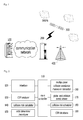
- Fig. 1 is a block diagram of a CSM-based analysis system for a collision risk according to an embodiment of the present invention.
- a CSM-based analysis system for a collision risk includes a CSM-based collision risk analysis server 100, a joint space operations center server 200 and a satellite 300.
- the satellite 300 collects various pieces of information about the coordinates, the sizes, the elements, etc. of a plurality of pieces of surrounding debris and transmits the information to the ground joint space operations center server 200.
- the joint space operations center server 200 composes a conjunction summary message based on the information collected from a global space monitoring network resource including the user satellite 300, a radar or an optical camera 400.
- the collision risk analysis server 100 analyzes, generates and displays various pieces of information such as a collision risk, approaching movement, etc. between the satellite operated by a user and the space debris based on the conjunction summary message.
- the CSM-based analysis system for a collision risk has a system architecture of 'Tree' easy to directly connect with a flight dynamics system that has to secure extendability of the system, facilitate the subsequent modification and run parallel with of a collision risk analysis of the space debris.
- a collision risk analysis server of a CSM-based analysis system for a collision risk will be described in more detail.
- FIG. 2 is a block diagram of a collision risk analysis server of a CSM-based analysis system for a collision risk according to an embodiment of the present invention.
- the collision risk analysis server of the CSM-based analysis system for a collision risk includes a main controller 110, an interface 120, a CSM analyzer 130, a collision risk calculator 140, an orbit determiner/analyzer 150, a multipurpose collision-avoidance maneuver calculator 160, a global and collision event viewer170, a collision risk scheduler 180, and a CSM database (DB) 190.
- a main controller 110 an interface 120, a CSM analyzer 130, a collision risk calculator 140, an orbit determiner/analyzer 150, a multipurpose collision-avoidance maneuver calculator 160, a global and collision event viewer170, a collision risk scheduler 180, and a CSM database (DB) 190.
- DB CSM database
- the interface 120 automatically receives the CSM and various external data from the exterior the joint space operations center server 200, and automatically transmits and receives system operation results to and from the exterior.
- the interface 120 sets up access and automatic receiving time to automatically transmit the CSM and various required data through an external site, and sets up time to automatically transmit the corresponding data to the external site requiring various result data calculated through the system.
- the CSM analyzer 130 automatically analyzes the conjunction summary message (CSM) transmitted from the U.S. joint space operations center (JSpOC) informing the collision risk between the satellite 300 operated by a user and the space debris, and manually analyzes a certain collision event.
- CSM conjunction summary message
- JSpOC joint space operations center
- the CSM analyzer 130 automatically receives the CSM if the joint space operations center server 200 generates the CSM about the user satellite 300, analyzes the received CSM, extracts the orbit information and covariance information about the user satellite 300 and space debris from the CSM, and transmits the extracted information to the collision risk calculator 140.
- the collision risk calculator 140 automatically calculates the collision risk between the user satellite 300 and the space debris in accordance with the analysis results of the CSM analyzer 130.
- the collision risk calculator 140 calculates the collision probability and the approaching distance between the satellite and the space debris, based on the orbit information and covariance information about the user satellite 300 and the space debris transmitted from the CSM analyzer 130.
- the collision risk calculator 140 further calculates the minimum approaching distance and approaching distances in radial, in-track and cross-track direction, based on the orbit information and covariance information about the user satellite 300 and the space debris, thereby analyzing a risk propensity about each collision event.
- an operator of the CSM-based the collision risk analysis server 100 in the CSM-based analysis system for the collision risk employs the CSM for determining whether to make the collision-avoidance maneuver plan and whether to perform precise orbit calculation of an approaching object, through an input device connected to the interface 120
- the orbit determiner/analyzer 150 uses the tracking data about the user satellite 300 or space debris acquired by the radar or the optical camera to perform the precise orbit calculation, and determines precise orbit information including the covariance.
- the CSM analyzer 130 receives the CSM about a certain satellite, and if a result from analyzing the detailed collision risk shows that the precise orbit determination and prediction are needed, the orbit determiner/analyzer 150 recalculates and predicts the precise orbit based on the orbit information and covariance information about the user satellite 300 and the approaching object with regard to the collision risk event selected from the CSM analyzer 130 by the operator.
- the data is processed to acquire the precise orbit information and the covariance information.
- the orbit determiner/analyzer 150 may transmit the acquired precise orbit information and covariance to be selected and recalculated in the collision risk calculator 140.
- the multipurpose collision-avoidance maneuver calculator 160 establishes the collision-avoidance maneuver plan optimized with regard to the plurality of pieces of space debris if the collision-avoidance maneuver is needed in the results from analyzing the collision risk.
- the collision risk calculator 140 determines that the collision risk is high since the detailed collision risk result exceeds a certain threshold, the corresponding collision events may be transmitted to the multipurpose collision-avoidance maneuver calculator 160, and the optimized collision-avoidance maneuver plan is selected to be established among individual collision events shown in the multipurpose collision-avoidance maneuver calculator 160.
- the multipurpose collision-avoidance maneuver calculator 160 not only makes a collision-avoidance maneuver plan optimized for a single object to avoid a collision risk with regard to a single approaching object, but also makes a collision-avoidance maneuver plan optimized for a plurality of objects to avoid a collision risk with regard to a plurality of approaching objects.
- the multipurpose collision-avoidance maneuver calculator 160 may take limited conditions to operations of the user satellite 300 into account, and more specifically may select the purposes such as the collision probability, the minimum approaching distance, and the radial direction distance when the user satellite 300 avoids the collision with the space debris, and at the same time consider the limited conditions to the operations together with the selected purposes, that is, the maximum allowable fuel usage, an avoidance maneuver start time, a ground track allowable error, etc.
- the multipurpose collision-avoidance maneuver calculator 160 may perform a Monte-Carlo simulation in consideration of an initial orbit error of the satellite, an error of a thruster, etc.
- the global and collision event viewer170 displays an approaching movement and a collision risk event of the user satellite to the space debris in space in the form of a two-dimension (2D) and a three-dimension (3D).
- the global and collision event viewer170 allows a current state of space objects including operating user satellites and other space debris to be displayed on the 3D display, and allows movement between a view point of the earth and view points of the user satellites to be displayed.
- the global and collision event viewer170 allows approaching situations to the collision event selected by an operator to be displayed in the 3D and 2D, so that the operator can visually determine a geometrical approaching direction with regard to collision situations, and situations before and after the approach.
- the global and collision event viewer170 arranges a current state of the collision risk analysis and the nearest collision event situations with regard to the user's respective satellites and displays them on a main screen, and arranges the automatic orbit determination execution with regard to the respective satellites and the current state of normal termination and displays them on the main screen.
- the collision risk scheduler 180 may set up a preliminary collision risk analysis threshold and detailed collision risk analysis thresholds with regard to the user satellite 300 in accordance with collision probability, the minimum approaching distance and the minimum distance in a radial direction, and sets up time for executing a collision risk automatic analysis into every hour with respect to each user satellite.
- the main controller 110 maintains organic connection among the foregoing elements, and particularly controls transmission between the elements and stores the CSM received through the interface 130 in the conjunction summary message DB 190.
- the main controller 110 may retrieve the past conjunction summary message about the satellite or space object, in which a user is interested, in the collision CSM DB 190 and thus determine the propensity for the collision risk.
Landscapes
- Engineering & Computer Science (AREA)
- Remote Sensing (AREA)
- Radar, Positioning & Navigation (AREA)
- Aviation & Aerospace Engineering (AREA)
- Physics & Mathematics (AREA)
- General Physics & Mathematics (AREA)
- Computer Networks & Wireless Communication (AREA)
- Chemical & Material Sciences (AREA)
- Combustion & Propulsion (AREA)
- Electromagnetism (AREA)
- Astronomy & Astrophysics (AREA)
- Traffic Control Systems (AREA)
- Life Sciences & Earth Sciences (AREA)
- General Life Sciences & Earth Sciences (AREA)
- Geophysics (AREA)
Abstract
Description
- The present invention relates to a conjunction summary message (CSM)-based analysis system for a collision risk, and more particularly to a CSM-based analysis system for a collision risk of space debris, which automatically analyzes the collision risk of an operator satellite based on a CSM informing the collision risk between the satellite and space debris while operating a global space monitoring network, enables manual analysis for the automatic analysis results into detailed collision risks in consideration of user convenience and efficiency, quickly reflects results of determining orbits of space objects or satellites to procedures of analyzing the detailed collision risks, allows the operator to establish various optimized collision-avoidance maneuvers while considering limited conditions of mission operations, and includes a display for depicting situations before and after the collision and situations before and after the maneuver in a three-dimension (3D).
- The following patent reference is related to a conventional method of determining collision-avoidance direction control, which acquires initial data about a target object, generates a plurality of preliminary maneuvers based on initial data, and provides the preliminary maneuvers optimized to avoid the collision, but has a problem that prediction of collision between a satellite and space debris is somewhat low.
- Korean Patent No.
10-0646856(2006. 11. 09 - The present invention is conceived to solve the foregoing problems, and an aspect of the present invention is to provide a CSM-based analysis system for a collision risk of space debris, which automatically analyzes the collision risk of an operator satellite based on a CSM of the joint space operations center server of United States joint space operations center (JSpOC) for alerting the collision risk between the satellite and space debris while operating a global space monitoring network, enables manual analysis for the automatic analysis results into detailed collision risks in consideration of user convenience and efficiency, quickly reflects results of determining orbits of space objects or satellites to procedures of analyzing the detailed collision risks, allows the operator to establish various optimized collision-avoidance maneuvers while considering limited conditions of mission operations, and includes a display for depicting situations before and after the collision and situations before and after the maneuver in a three-dimension (3D).
- In accordance with one aspect of the present invention, there is provided a conjunction summary message (CSM)-based analysis system for a collision risk, the system comprising: space debris which moves in space; a satellite which collects data about space debris; a joint space operations center server which receives information collected by the satellite and calculates orbit information and covariance information about the satellite and the space debris; and a collision risk analysis server which analyzes the collision risk between the satellite and the space debris based on the orbit information and the covariance information calculated by the joint space operations center server, the collision risk analysis server comprising: an interface which receives a conjunction summary message (CSM) from the joint space operations center server, and transmits and receives various data; a CSM analyzer which automatically analyzes the conjunction summary message transmitted from the joint space operations center server of United States joint space operations center (JSpOC) for alerting the collision risk between the satellite and the space debris, and manually analyzes a certain collision event; a collision risk calculator which automatically calculates the collision risk between the satellite and the space debris in accordance with analysis results of the CSM analyzer; an orbit determiner/analyzer which precisely calculates an orbit based on the tracking data about the user satellite or the space debris acquired by the radar or the optical camera, and determines precise orbit information comprising covariance; a multipurpose collision-avoidance maneuver calculator which makes a collision-avoidance maneuver plan optimized with regard to a plurality of pieces of space debris when a collision-avoidance maneuver is needed based on the analysis results of the CSM analyzer; and a collision risk scheduler which sets up a preliminary collision risk analysis threshold and detailed collision risk analysis thresholds with regard to the user satellite in accordance with collision probability, the minimum approaching distance and the minimum distance in a radial direction, and sets up time for executing a collision risk automatic analysis into every hour with respect to each user satellite.
- A CSM-based analysis system according to embodiments of the present invention have effects on improving precise prediction of collision between the satellite and the space debris based on a CSM informing the collision risk between the satellite and the space debris while operating a global space monitoring network, and significantly reducing a total time taken in determining and analyzing a precise orbit of the space debris and making an optimized collision-avoidance maneuver plan, through the effective user interface and system.
-
-
Fig. 1 is a block diagram of a CSM-based analysis system for a collision risk according to an embodiment of the present invention, and -
Fig. 2 is a block diagram of a collision risk analysis server of a CSM-based analysis system for a collision risk according to an embodiment of the present invention. - Hereinafter, exemplary embodiments according to the present invention will be described with reference to accompanying drawings. Also, terms and words used in the following description and claims have to be interpreted by not the limited meaning of the typical or dictionary definition, but the meaning and concept corresponding to the technical idea of the present invention on the assumption that the inventor can properly define the concept of the terms in order to describe his/her own invention in the best way.
- Accordingly, the disclosure in the specification and the configurations shown in the drawings are just preferred embodiments of the present invention and do not cover all the technical idea of the present invention. Thus, it should be appreciated that such embodiments may be replaced by various equivalents and modifications at a point of time when the present application is filed.
-
Fig. 1 is a block diagram of a CSM-based analysis system for a collision risk according to an embodiment of the present invention, and - As shown in
Fig. 1 , a CSM-based analysis system for a collision risk according to an embodiment of the present invention includes a CSM-based collisionrisk analysis server 100, a joint spaceoperations center server 200 and asatellite 300. - The
satellite 300 collects various pieces of information about the coordinates, the sizes, the elements, etc. of a plurality of pieces of surrounding debris and transmits the information to the ground joint spaceoperations center server 200. - The joint space
operations center server 200 composes a conjunction summary message based on the information collected from a global space monitoring network resource including theuser satellite 300, a radar or anoptical camera 400. - Further, the collision
risk analysis server 100 analyzes, generates and displays various pieces of information such as a collision risk, approaching movement, etc. between the satellite operated by a user and the space debris based on the conjunction summary message. - For reference, the CSM-based analysis system for a collision risk according to an embodiment of the present invention has a system architecture of 'Tree' easy to directly connect with a flight dynamics system that has to secure extendability of the system, facilitate the subsequent modification and run parallel with of a collision risk analysis of the space debris.
- Referring to
Fig. 2 , a collision risk analysis server of a CSM-based analysis system for a collision risk will be described in more detail. - For reference,
Fig. 2 is a block diagram of a collision risk analysis server of a CSM-based analysis system for a collision risk according to an embodiment of the present invention. - As shown in
Fig. 2 , the collision risk analysis server of the CSM-based analysis system for a collision risk according to an embodiment of the present invention includes amain controller 110, aninterface 120, aCSM analyzer 130, acollision risk calculator 140, an orbit determiner/analyzer 150, a multipurpose collision-avoidance maneuver calculator 160, a global and collision event viewer170, acollision risk scheduler 180, and a CSM database (DB) 190. - The
interface 120 automatically receives the CSM and various external data from the exterior the joint spaceoperations center server 200, and automatically transmits and receives system operation results to and from the exterior. - Also, the
interface 120 sets up access and automatic receiving time to automatically transmit the CSM and various required data through an external site, and sets up time to automatically transmit the corresponding data to the external site requiring various result data calculated through the system. - The
CSM analyzer 130 automatically analyzes the conjunction summary message (CSM) transmitted from the U.S. joint space operations center (JSpOC) informing the collision risk between thesatellite 300 operated by a user and the space debris, and manually analyzes a certain collision event. - That is, the
CSM analyzer 130 automatically receives the CSM if the joint spaceoperations center server 200 generates the CSM about theuser satellite 300, analyzes the received CSM, extracts the orbit information and covariance information about theuser satellite 300 and space debris from the CSM, and transmits the extracted information to thecollision risk calculator 140. - The
collision risk calculator 140 automatically calculates the collision risk between theuser satellite 300 and the space debris in accordance with the analysis results of theCSM analyzer 130. - That is, the
collision risk calculator 140 calculates the collision probability and the approaching distance between the satellite and the space debris, based on the orbit information and covariance information about theuser satellite 300 and the space debris transmitted from theCSM analyzer 130. - Also, the
collision risk calculator 140 further calculates the minimum approaching distance and approaching distances in radial, in-track and cross-track direction, based on the orbit information and covariance information about theuser satellite 300 and the space debris, thereby analyzing a risk propensity about each collision event. - If the calculation result of the
collision risk calculator 140 goes beyond a preset collision risk threshold, an operator of the CSM-based the collisionrisk analysis server 100 in the CSM-based analysis system for the collision risk according to an embodiment of the present invention employs the CSM for determining whether to make the collision-avoidance maneuver plan and whether to perform precise orbit calculation of an approaching object, through an input device connected to theinterface 120 - The orbit determiner/
analyzer 150 uses the tracking data about theuser satellite 300 or space debris acquired by the radar or the optical camera to perform the precise orbit calculation, and determines precise orbit information including the covariance. - The
CSM analyzer 130 receives the CSM about a certain satellite, and if a result from analyzing the detailed collision risk shows that the precise orbit determination and prediction are needed, the orbit determiner/analyzer 150 recalculates and predicts the precise orbit based on the orbit information and covariance information about theuser satellite 300 and the approaching object with regard to the collision risk event selected from theCSM analyzer 130 by the operator. - If the radar tracking data and the optical tracking data about the
user satellite 300 or the space debris are received, the data is processed to acquire the precise orbit information and the covariance information. - The orbit determiner/
analyzer 150 may transmit the acquired precise orbit information and covariance to be selected and recalculated in thecollision risk calculator 140. - The multipurpose collision-avoidance maneuver calculator 160 establishes the collision-avoidance maneuver plan optimized with regard to the plurality of pieces of space debris if the collision-avoidance maneuver is needed in the results from analyzing the collision risk.
- If the
collision risk calculator 140 determines that the collision risk is high since the detailed collision risk result exceeds a certain threshold, the corresponding collision events may be transmitted to the multipurpose collision-avoidance maneuver calculator 160, and the optimized collision-avoidance maneuver plan is selected to be established among individual collision events shown in the multipurpose collision-avoidance maneuver calculator 160. - The multipurpose collision-avoidance maneuver calculator 160 not only makes a collision-avoidance maneuver plan optimized for a single object to avoid a collision risk with regard to a single approaching object, but also makes a collision-avoidance maneuver plan optimized for a plurality of objects to avoid a collision risk with regard to a plurality of approaching objects.
- The multipurpose collision-avoidance maneuver calculator 160 may take limited conditions to operations of the
user satellite 300 into account, and more specifically may select the purposes such as the collision probability, the minimum approaching distance, and the radial direction distance when theuser satellite 300 avoids the collision with the space debris, and at the same time consider the limited conditions to the operations together with the selected purposes, that is, the maximum allowable fuel usage, an avoidance maneuver start time, a ground track allowable error, etc. - The multipurpose collision-avoidance maneuver calculator 160 may perform a Monte-Carlo simulation in consideration of an initial orbit error of the satellite, an error of a thruster, etc.
- The global and collision event viewer170 displays an approaching movement and a collision risk event of the user satellite to the space debris in space in the form of a two-dimension (2D) and a three-dimension (3D).
- Through a global viewer function The global and collision event viewer170 allows a current state of space objects including operating user satellites and other space debris to be displayed on the 3D display, and allows movement between a view point of the earth and view points of the user satellites to be displayed.
- Meanwhile, through a collision event viewer function, the global and collision event viewer170 allows approaching situations to the collision event selected by an operator to be displayed in the 3D and 2D, so that the operator can visually determine a geometrical approaching direction with regard to collision situations, and situations before and after the approach.
- Also, the global and collision event viewer170 arranges a current state of the collision risk analysis and the nearest collision event situations with regard to the user's respective satellites and displays them on a main screen, and arranges the automatic orbit determination execution with regard to the respective satellites and the current state of normal termination and displays them on the main screen.
- The
collision risk scheduler 180 may set up a preliminary collision risk analysis threshold and detailed collision risk analysis thresholds with regard to theuser satellite 300 in accordance with collision probability, the minimum approaching distance and the minimum distance in a radial direction, and sets up time for executing a collision risk automatic analysis into every hour with respect to each user satellite. - The
main controller 110 maintains organic connection among the foregoing elements, and particularly controls transmission between the elements and stores the CSM received through theinterface 130 in the conjunction summary message DB 190. - Also, the
main controller 110 may retrieve the past conjunction summary message about the satellite or space object, in which a user is interested, in the collision CSM DB 190 and thus determine the propensity for the collision risk. - Although some embodiments have been described herein with reference to the accompanying drawings, it will be understood by those skilled in the art that these embodiments are provided for illustration only, and various modifications, changes, alterations and equivalent embodiments can be made without departing from the scope of the present invention. Therefore, the scope and sprit of the present invention should be defined only by the accompanying claims and equivalents thereof.
-
- 110 : main controller
- 120 : interface
- 130 : CSM analyzer
- 140 : collision risk calculator
- 150 : orbit determiner/analyzer
- 160 : multipurpose collision-avoidance maneuver calculator
- 170 : global and collision event viewer
- 180 : collision risk scheduler
- 190 : CSM database (DB)
Claims (10)
- A conjunction summary message (CSM)-based analysis system for a collision risk, the system comprising:space debris which moves in space;a user satellite which monitors the space debris in the sky and collects data;a radar or an optical camera which monitors the space debris over the earth and collects tracking data;a joint space operations center server which receives information collected by the user satellite and calculates orbit information and covariance information about the user satellite and the space debris to compose a conjunction summary message; anda collision risk analysis server which analyzes the collision risk between the user satellite and the space debris based on the orbit information and the covariance information calculated by the joint space operations center server.
- The CSM-based analysis system for the collision risk according to claim 1, wherein the collision risk analysis server comprises:an interface which receives a conjunction summary message (CSM) composed by the joint space operations center server, and transmits and receives various data;a CSM analyzer which automatically analyzes the conjunction summary message transmitted from the joint space operations center server of United States joint space operations center (JSpOC) for alerting the collision risk between the user satellite and the space debris, and manually analyzes a certain collision event;a collision risk calculator which automatically calculates the collision risk between the user satellite and the space debris in accordance with analysis results of the CSM analyzer;an orbit determiner/analyzer which precisely calculates an orbit based on the tracking data about the user satellite or the space debris acquired by the radar or the optical camera, and determines precise orbit information comprising covariance;a multipurpose collision-avoidance maneuver calculator which makes a collision-avoidance maneuver plan optimized with regard to a plurality of pieces of space debris when a collision-avoidance maneuver is needed based on the analysis results of the CSM analyzer; anda collision risk scheduler which sets up a preliminary collision risk analysis threshold and detailed collision risk analysis thresholds with regard to the user satellite in accordance with collision probability, the minimum approaching distance and the minimum distance in a radial direction, and sets up time for executing a collision risk automatic analysis into every hour with respect to each user satellite.
- The CSM-based analysis system for the collision risk according to claim 2, wherein the collision risk analysis server further comprises a global and collision event viewer which displays an approaching movement and a collision risk event of the user satellite to the space debris in space in the form of a two-dimension (2D) and a three-dimension (3D).
- The CSM-based analysis system for the collision risk according to claim 2, wherein the CSM analyzer automatically receives the CSM through the interface 120 if the joint space operations center server generates the CSM with regard to the user satellite, and extracts the orbit information and the covariance information about the user satellite and the space debris from the received CSM through the analysis of the received CSM.
- The CSM-based analysis system for the collision risk according to claim 4, wherein the collision risk calculator calculates the collision probability and the approaching distance between the satellite and the space debris based on the orbit information and the covariance information about the user satellite and the space debris transmitted from the CSM analyzer.
- The CSM-based analysis system for the collision risk according to claim 4, wherein the collision risk calculator analyzes a risk propensity about each collision event by further calculating approaching distances in radial, in-track and cross-track directions, and the minimum approaching distance based on the orbit information and the covariance information about the user satellite and the space debris.
- The CSM-based analysis system for the collision risk according to claim 4, wherein the multipurpose collision-avoidance maneuver calculator makes a collision-avoidance maneuver plan optimized with regard to the collision event if a detailed collision risk result of the collision risk calculator exceeds the threshold.
- The CSM-based analysis system for the collision risk according to claim 7, wherein the multipurpose collision-avoidance maneuver calculator makes a collision-avoidance maneuver plan optimized for a single object to avoid a collision risk with regard to a single approaching object, and makes a collision-avoidance maneuver plan optimized for a plurality of objects to avoid a collision risk with regard to a plurality of approaching objects.
- The CSM-based analysis system for the collision risk according to claim 7, wherein the multipurpose collision-avoidance maneuver calculator makes a collision-avoidance maneuver plan against the space debris while simultaneously considering the maximum allowable fuel usage, an avoidance maneuver start time, and a ground track allowable error.
- The CSM-based analysis system for the collision risk according to claim 3, wherein the global and collision event viewer displays a current state of space objects including the user satellites and the space debris in the form of the 3D, and displays movement between a view point of the earth and view points of the user satellites through a global viewer function.
Applications Claiming Priority (2)
| Application Number | Priority Date | Filing Date | Title |
|---|---|---|---|
| KR1020130128504A KR101537301B1 (en) | 2013-10-28 | 2013-10-28 | System for analysis of collision risk based on csm |
| PCT/KR2013/010612 WO2015064818A1 (en) | 2013-10-28 | 2013-11-21 | System for analyzing risk of collision based on csm |
Publications (2)
| Publication Number | Publication Date |
|---|---|
| EP2937798A1 true EP2937798A1 (en) | 2015-10-28 |
| EP2937798A4 EP2937798A4 (en) | 2016-09-14 |
Family
ID=53004402
Family Applications (1)
| Application Number | Title | Priority Date | Filing Date |
|---|---|---|---|
| EP13895444.1A Withdrawn EP2937798A4 (en) | 2013-10-28 | 2013-11-21 | COLLISION RISK ANALYSIS SYSTEM BASED ON A CSM |
Country Status (4)
| Country | Link |
|---|---|
| US (1) | US20150134295A1 (en) |
| EP (1) | EP2937798A4 (en) |
| KR (1) | KR101537301B1 (en) |
| WO (1) | WO2015064818A1 (en) |
Cited By (2)
| Publication number | Priority date | Publication date | Assignee | Title |
|---|---|---|---|---|
| CN109541711A (en) * | 2018-11-15 | 2019-03-29 | 北京遥感设备研究所 | It is a kind of based on staring infrared unmanned plane warning system and method |
| EP4016504A1 (en) | 2020-12-15 | 2022-06-22 | OKAPI:Orbits GmbH | Method, computer program and hardware for determining a collision probability |
Families Citing this family (26)
| Publication number | Priority date | Publication date | Assignee | Title |
|---|---|---|---|---|
| US10293959B2 (en) * | 2015-07-28 | 2019-05-21 | Analytical Graphics Inc. | Probability and frequency of orbital encounters |
| KR101866014B1 (en) * | 2016-03-22 | 2018-06-08 | 현대자동차주식회사 | Apparatus for avoiding side crash in vehicle and method thereof |
| CN106709145B (en) * | 2016-11-23 | 2018-03-20 | 清华大学 | The parallel calculating method that extensive space junk distribution numerical value develops |
| EP3633528A4 (en) | 2017-05-30 | 2021-06-09 | IUCF-HYU (Industry-University Cooperation Foundation Hanyang University) | COLLISION PREDICTION AND CONFLICT PREVENTION PROCESS BETWEEN MULTIPLE MOBILE BODIES |
| CN109581363B (en) * | 2018-12-03 | 2022-04-22 | 中国电波传播研究所(中国电子科技集团公司第二十二研究所) | A small-size space debris detection and parameter extraction method based on incoherent scattering radar |
| CN109815606B (en) * | 2019-01-30 | 2023-03-24 | 上海卫星工程研究所 | Method and system for analyzing influence of error chain on fragment collision removal success rate |
| KR102204460B1 (en) * | 2019-05-23 | 2021-01-19 | 한국 천문 연구원 | Method of collision assessments and probability calculations of space objects |
| US11780612B1 (en) * | 2019-09-23 | 2023-10-10 | United States of America Administrator of NASA | Space traffic management system architecture |
| CN111428339B (en) * | 2020-02-18 | 2023-09-01 | 北京空间飞行器总体设计部 | Space object long-term collision risk analysis method based on space density model |
| JP7261350B2 (en) * | 2020-03-10 | 2023-04-19 | 三菱電機株式会社 | Space Information Recorder, Collision Avoidance Support Program, and Collision Avoidance Support Device |
| AU2021279256B2 (en) * | 2020-05-25 | 2023-04-06 | Airbus Defence And Space Sas | Method for estimating collision between at least one piece of space debris and a satellite |
| WO2022046350A2 (en) * | 2020-07-31 | 2022-03-03 | Michael Kezirian | Methods and systems for reducing risk of air collisions |
| CN112710995B (en) * | 2020-12-23 | 2023-04-25 | 中国人民解放军63921部队 | Space debris ranging data simulation method |
| CN112623283B (en) * | 2020-12-30 | 2024-06-18 | 苏州三六零智能安全科技有限公司 | Space object anomaly detection method, device, equipment and storage medium |
| WO2023141303A2 (en) | 2022-01-21 | 2023-07-27 | Slingshot Aerospace, Inc. | Methods and systems for streaming buffer numerical propagation |
| CN114326774B (en) * | 2022-03-14 | 2022-05-24 | 北京航天驭星科技有限公司 | Method and system for generating collision avoidance strategy of spacecraft |
| CN114691717A (en) * | 2022-04-18 | 2022-07-01 | 扬州大学 | Satellite risk assessment visualization method based on STK and QT interaction |
| CN115879211B (en) * | 2022-08-10 | 2025-08-29 | 西北工业大学 | A space station companion satellite orbit design method for space debris threat warning |
| CN115509123B (en) * | 2022-09-16 | 2024-06-21 | 北京理工大学 | Rapid prediction and avoidance trajectory optimization method for satellite constellation collision |
| CN115688996B (en) * | 2022-10-19 | 2025-08-15 | 中国人民解放军军事航天部队航天工程大学 | Low-orbit giant constellation collision risk analysis method, system and storage medium |
| US20240150045A1 (en) * | 2022-11-09 | 2024-05-09 | Slingshot Aerospace, Inc. | Methods and system for space traffic coordination and data sharing for collision avoidance |
| CN116861241B (en) * | 2023-07-11 | 2024-02-20 | 北京天工科仪空间技术有限公司 | An artificial intelligence-based space debris collision probability prediction method and system |
| CN117048853B (en) * | 2023-08-29 | 2024-01-23 | 北京航天驭星科技有限公司 | Method, system, electronic equipment and medium for adjusting rail control by adopting electric pushing mode |
| WO2025114930A1 (en) * | 2023-11-27 | 2025-06-05 | NorthStar Earth & Space Inc. | System and method for generating a plurality of celestial image features from a plurality of images of a sky |
| CN119989657B (en) * | 2025-01-13 | 2026-01-13 | 中国人民解放军军事航天部队航天工程大学 | Digital twin method and system for detecting space debris collision |
| CN120429522B (en) * | 2025-04-16 | 2025-10-28 | 北京控制工程研究所 | An analytical model method for collision threat area prediction and collision risk assessment |
Family Cites Families (10)
| Publication number | Priority date | Publication date | Assignee | Title |
|---|---|---|---|---|
| KR100646856B1 (en) | 2005-09-29 | 2006-11-23 | 한국전자통신연구원 | Integrated Mission Analysis Plan Device and Method for Satellite Control |
| JP2008126876A (en) * | 2006-11-22 | 2008-06-05 | Mitsubishi Electric Corp | Observation satellite group control system, observation satellite, ground station, and observation satellite group control method |
| RU2505461C1 (en) * | 2009-11-25 | 2014-01-27 | Поулос Эйр Энд Спейс | Stabilisation of unstable fragments of space garbage |
| US20120046863A1 (en) * | 2010-08-12 | 2012-02-23 | The Government Of The Us, As Represented By The Secretary Of The Navy | Orbit covariance, estimation and analysis tool |
| KR101222501B1 (en) * | 2010-12-15 | 2013-01-16 | 한국항공우주연구원 | System and Method for Collision Risk Management between Satellite and Space Debris |
| US9020748B2 (en) * | 2011-07-26 | 2015-04-28 | Lawrence Livermore National Security, Llc | Scheduler for monitoring objects orbiting earth using satellite-based telescopes |
| US20130082146A1 (en) * | 2011-09-30 | 2013-04-04 | Raytheon Bbn Technologies Corp. | System and method for creating an artificial atmosphere for the removal of space debris |
| US8833702B2 (en) * | 2012-05-07 | 2014-09-16 | Robert Briskman | Autonomous satellite orbital debris avoidance system and method |
| US9586704B2 (en) * | 2013-05-02 | 2017-03-07 | Lawrence Livermore National Security, Llc | Modeling the long-term evolution of space debris |
| US20150088475A1 (en) * | 2013-09-26 | 2015-03-26 | The Aerospace Corporation | Space debris visualization, characterization and volume modeling |
-
2013
- 2013-10-28 KR KR1020130128504A patent/KR101537301B1/en active Active
- 2013-11-21 WO PCT/KR2013/010612 patent/WO2015064818A1/en not_active Ceased
- 2013-11-21 EP EP13895444.1A patent/EP2937798A4/en not_active Withdrawn
- 2013-11-21 US US14/374,123 patent/US20150134295A1/en not_active Abandoned
Cited By (2)
| Publication number | Priority date | Publication date | Assignee | Title |
|---|---|---|---|---|
| CN109541711A (en) * | 2018-11-15 | 2019-03-29 | 北京遥感设备研究所 | It is a kind of based on staring infrared unmanned plane warning system and method |
| EP4016504A1 (en) | 2020-12-15 | 2022-06-22 | OKAPI:Orbits GmbH | Method, computer program and hardware for determining a collision probability |
Also Published As
| Publication number | Publication date |
|---|---|
| KR20150048953A (en) | 2015-05-11 |
| KR101537301B1 (en) | 2015-07-20 |
| WO2015064818A1 (en) | 2015-05-07 |
| US20150134295A1 (en) | 2015-05-14 |
| EP2937798A4 (en) | 2016-09-14 |
Similar Documents
| Publication | Publication Date | Title |
|---|---|---|
| EP2937798A1 (en) | System for analyzing risk of collision based on csm | |
| US9310809B2 (en) | Systems and methods for collaboratively controlling at least one aircraft | |
| US8781654B2 (en) | Method and device for aiding the approach of an aircraft during an approach phase for the purpose of landing | |
| US20210390867A1 (en) | Big data-based autonomous flight drone system and autonomous flight method therefor | |
| US10330493B2 (en) | Systems and methods for displaying position sensitive datalink messages on avionics displays | |
| US8825366B2 (en) | Method and device for determining an optimal flight trajectory followed by an aircraft | |
| US9523580B2 (en) | System and method for aiding a pilot in locating an out of view landing site | |
| US7606658B2 (en) | Financial decision aid for 4-D navigation | |
| EP3032518B1 (en) | Aircraft turns for interval managent | |
| US20100321488A1 (en) | Landing aid device and method | |
| Braun et al. | Operational support to collision avoidance activities by ESA’s space debris office | |
| US20140350755A1 (en) | Method and system for aiding piloting when selecting a trajectory of approach | |
| EP2613125B1 (en) | System and method for indicating a perspective cockpit field-of-view on a vertical situation display | |
| EP3474257A1 (en) | System and method for integration of smart trajectory generation and decision aid applications in legacy cockpits | |
| EP2664549B1 (en) | Methods and systems for representing missed approach information in perspective view on a cockpit display | |
| US20190122570A1 (en) | Method for determining endpoint(s) for deciding to trigger evasive maneuver by an aircraft, associated device and computer program | |
| US9761148B2 (en) | Airborne separation assurance system and required time of arrival function cooperation | |
| US12499775B2 (en) | Device and method for assisting aircraft guidance | |
| EP2608187B1 (en) | System for flight management of aircraft in segregated airspace | |
| EP3012816A1 (en) | Methods and systems for managing situation awareness information and alerts in a cockpit display | |
| US10565884B2 (en) | Automated selection of environmental data coverage | |
| US12246856B2 (en) | Rocket launch assistance device, rocket launch assistance system, rocket launch assistance method, space information recorder, space traffic management device, and mega-constellation business device | |
| EP3992945A1 (en) | Systems and methods for vehicle operator and dispatcher interfacing | |
| EP3809395B1 (en) | Method and system for policy-based traffic encounter assessment to detect and avoid traffic | |
| WO2022197370A2 (en) | Methods and systems for threat aircraft detection using multiple sensors |
Legal Events
| Date | Code | Title | Description |
|---|---|---|---|
| PUAI | Public reference made under article 153(3) epc to a published international application that has entered the european phase |
Free format text: ORIGINAL CODE: 0009012 |
|
| 17P | Request for examination filed |
Effective date: 20150420 |
|
| AK | Designated contracting states |
Kind code of ref document: A1 Designated state(s): AL AT BE BG CH CY CZ DE DK EE ES FI FR GB GR HR HU IE IS IT LI LT LU LV MC MK MT NL NO PL PT RO RS SE SI SK SM TR |
|
| AX | Request for extension of the european patent |
Extension state: BA ME |
|
| A4 | Supplementary search report drawn up and despatched |
Effective date: 20160816 |
|
| RIC1 | Information provided on ipc code assigned before grant |
Ipc: B64G 1/66 20060101ALI20160809BHEP Ipc: B64G 99/00 20090101ALI20160809BHEP Ipc: G06F 19/00 20110101AFI20160809BHEP Ipc: B64G 3/00 20060101ALI20160809BHEP Ipc: B64G 1/24 20060101ALI20160809BHEP Ipc: G01S 13/93 20060101ALI20160809BHEP |
|
| DAX | Request for extension of the european patent (deleted) | ||
| STAA | Information on the status of an ep patent application or granted ep patent |
Free format text: STATUS: THE APPLICATION HAS BEEN WITHDRAWN |
|
| 18W | Application withdrawn |
Effective date: 20181113 |