EP2911090B1 - Verfahren und Anordnung zur Identifizierung einer Differenz zwischen einem ersten 3D-Modell einer Umgebung und einem zweiten 3D-Modell der Umgebung - Google Patents
Verfahren und Anordnung zur Identifizierung einer Differenz zwischen einem ersten 3D-Modell einer Umgebung und einem zweiten 3D-Modell der Umgebung Download PDFInfo
- Publication number
- EP2911090B1 EP2911090B1 EP14165561.3A EP14165561A EP2911090B1 EP 2911090 B1 EP2911090 B1 EP 2911090B1 EP 14165561 A EP14165561 A EP 14165561A EP 2911090 B1 EP2911090 B1 EP 2911090B1
- Authority
- EP
- European Patent Office
- Prior art keywords
- model
- point
- information
- difference
- difference value
- Prior art date
- Legal status (The legal status is an assumption and is not a legal conclusion. Google has not performed a legal analysis and makes no representation as to the accuracy of the status listed.)
- Active
Links
Images

Classifications
-
- G—PHYSICS
- G06—COMPUTING OR CALCULATING; COUNTING
- G06V—IMAGE OR VIDEO RECOGNITION OR UNDERSTANDING
- G06V20/00—Scenes; Scene-specific elements
- G06V20/10—Terrestrial scenes
- G06V20/13—Satellite images
-
- G—PHYSICS
- G06—COMPUTING OR CALCULATING; COUNTING
- G06F—ELECTRIC DIGITAL DATA PROCESSING
- G06F18/00—Pattern recognition
- G06F18/20—Analysing
- G06F18/22—Matching criteria, e.g. proximity measures
-
- G—PHYSICS
- G06—COMPUTING OR CALCULATING; COUNTING
- G06T—IMAGE DATA PROCESSING OR GENERATION, IN GENERAL
- G06T17/00—Three-dimensional [3D] modelling for computer graphics
- G06T17/05—Geographic models
-
- G—PHYSICS
- G06—COMPUTING OR CALCULATING; COUNTING
- G06T—IMAGE DATA PROCESSING OR GENERATION, IN GENERAL
- G06T7/00—Image analysis
- G06T7/40—Analysis of texture
- G06T7/49—Analysis of texture based on structural texture description, e.g. using primitives or placement rules
-
- G—PHYSICS
- G06—COMPUTING OR CALCULATING; COUNTING
- G06V—IMAGE OR VIDEO RECOGNITION OR UNDERSTANDING
- G06V10/00—Arrangements for image or video recognition or understanding
- G06V10/40—Extraction of image or video features
- G06V10/54—Extraction of image or video features relating to texture
-
- G—PHYSICS
- G06—COMPUTING OR CALCULATING; COUNTING
- G06V—IMAGE OR VIDEO RECOGNITION OR UNDERSTANDING
- G06V10/00—Arrangements for image or video recognition or understanding
- G06V10/70—Arrangements for image or video recognition or understanding using pattern recognition or machine learning
- G06V10/74—Image or video pattern matching; Proximity measures in feature spaces
- G06V10/75—Organisation of the matching processes, e.g. simultaneous or sequential comparisons of image or video features; Coarse-fine approaches, e.g. multi-scale approaches; using context analysis; Selection of dictionaries
- G06V10/757—Matching configurations of points or features
-
- G—PHYSICS
- G06—COMPUTING OR CALCULATING; COUNTING
- G06V—IMAGE OR VIDEO RECOGNITION OR UNDERSTANDING
- G06V10/00—Arrangements for image or video recognition or understanding
- G06V10/70—Arrangements for image or video recognition or understanding using pattern recognition or machine learning
- G06V10/74—Image or video pattern matching; Proximity measures in feature spaces
- G06V10/761—Proximity, similarity or dissimilarity measures
-
- G—PHYSICS
- G06—COMPUTING OR CALCULATING; COUNTING
- G06V—IMAGE OR VIDEO RECOGNITION OR UNDERSTANDING
- G06V20/00—Scenes; Scene-specific elements
- G06V20/60—Type of objects
- G06V20/64—Three-dimensional [3D] objects
- G06V20/647—Three-dimensional [3D] objects by matching two-dimensional images to three-dimensional objects
-
- G—PHYSICS
- G06—COMPUTING OR CALCULATING; COUNTING
- G06V—IMAGE OR VIDEO RECOGNITION OR UNDERSTANDING
- G06V20/00—Scenes; Scene-specific elements
- G06V20/60—Type of objects
- G06V20/64—Three-dimensional [3D] objects
- G06V20/653—Three-dimensional [3D] objects by matching three-dimensional models, e.g. conformal mapping of Riemann surfaces
-
- G—PHYSICS
- G06—COMPUTING OR CALCULATING; COUNTING
- G06F—ELECTRIC DIGITAL DATA PROCESSING
- G06F18/00—Pattern recognition
- G06F18/20—Analysing
- G06F18/24—Classification techniques
- G06F18/243—Classification techniques relating to the number of classes
- G06F18/2433—Single-class perspective, e.g. one-against-all classification; Novelty detection; Outlier detection
-
- G—PHYSICS
- G06—COMPUTING OR CALCULATING; COUNTING
- G06T—IMAGE DATA PROCESSING OR GENERATION, IN GENERAL
- G06T2207/00—Indexing scheme for image analysis or image enhancement
- G06T2207/10—Image acquisition modality
- G06T2207/10028—Range image; Depth image; 3D point clouds
-
- G—PHYSICS
- G06—COMPUTING OR CALCULATING; COUNTING
- G06T—IMAGE DATA PROCESSING OR GENERATION, IN GENERAL
- G06T2207/00—Indexing scheme for image analysis or image enhancement
- G06T2207/30—Subject of image; Context of image processing
- G06T2207/30181—Earth observation
- G06T2207/30184—Infrastructure
-
- G—PHYSICS
- G06—COMPUTING OR CALCULATING; COUNTING
- G06V—IMAGE OR VIDEO RECOGNITION OR UNDERSTANDING
- G06V10/00—Arrangements for image or video recognition or understanding
- G06V10/70—Arrangements for image or video recognition or understanding using pattern recognition or machine learning
- G06V10/77—Processing image or video features in feature spaces; using data integration or data reduction, e.g. principal component analysis [PCA] or independent component analysis [ICA] or self-organising maps [SOM]; Blind source separation
- G06V10/80—Fusion, i.e. combining data from various sources at the sensor level, preprocessing level, feature extraction level or classification level
- G06V10/803—Fusion, i.e. combining data from various sources at the sensor level, preprocessing level, feature extraction level or classification level of input or preprocessed data
-
- G—PHYSICS
- G06—COMPUTING OR CALCULATING; COUNTING
- G06V—IMAGE OR VIDEO RECOGNITION OR UNDERSTANDING
- G06V2201/00—Indexing scheme relating to image or video recognition or understanding
- G06V2201/12—Acquisition of 3D measurements of objects
Definitions
- the present disclosure relates to a method and arrangement for identifying a difference between a first 3D model of an environment and a second 3D model of the environment.
- the present disclosure relates to identifying a difference, wherein the first and second 3D model each comprise a plurality of points or parts, and wherein each point or part of the first and second model comprises geometrical information and texture information
- the geographical information can comprise digital maps having superposed information layers such as infrastructure, terrain type and different types of objects.
- This way of providing digital maps is time consuming and comprises forming two dimensional maps comprising capturing images of the terrain from an aircraft and post-processing of the captured images. It is an even more time consuming process to form three dimensional maps from captured images or range data sets of the terrain/infrastructure.
- WO 2009/003529 relates to another type of geographical information system. It relates to an arrangement and a method for providing a three dimensional map representation of an area.
- the arrangement comprises a processing unit arranged to, for a plurality of time recorded, overlapping images of the area to be stereo processed, associate navigation states so that each pixel of each time recorded image is correlated to a corresponding navigation state and to perform the stereo processing based on the associated navigation states that all pixels in the map representation are specified in three geographical dimensions.
- One object of the present invention is to improve the process of identifying differences in an environment.
- the first and second 3D model each comprises a plurality of points or parts, wherein each point or part of the first and second model comprises geometrical information and texture information. Corresponding points or parts of the first and second 3D model are matched based on the geometrical information and/or the texture information. The matched points or parts of the first and second model are compared to determine at least one difference value based on the geometrical information and the texture information of the first and second model.
- This method can be performed in a highly automated way, thus reducing the amount of time and/or workload an operator has to spend for identifying differences.
- an uncertainty for the geometrical information is associated to each point or part of the respective 3D model and an uncertainty for the texture information is associated to each point or part of the respective model.
- a difference between the first and second model is identified for each point or part based on the determined at least one difference value and based on the geometrical information uncertainty for the respective model and/or the texture information uncertainty for the respective model.
- the geometrical information uncertainty at each point or part is based on a local geometry of the 3D model at that point or part.
- the geometrical information uncertainty and/or texture information uncertainty is based on a number of measurements on which the respective model is based for each point or part of the respective 3D models.
- the geometrical information uncertainty and/or texture information uncertainty is based on a spread in measurements on which the respective model is based for each point or part of the respective 3D models.
- the geometrical information uncertainty comprises a value for the uncertainty in at least two directions and/or at least one value related to a distance and/or at least one probability value.
- the texture information comprises colour information and/or grey scale information.
- the texture information uncertainty comprises an uncertainty related to the colour and/or greyscale and/or a frequency value and/or a grey scale value and/or a percentage value.
- comparing the first and second 3D model comprises, for each point or part of the first 3D model, searching for a closest point in the second 3D model and to determine the at least one difference based on a found closest point in the second 3D model.
- comparing the first and second 3D model further comprises, for each point or part of the first 3D model, searching for a closest point in the second 3D model to determine at least one first difference value for that point or part. It also comprises, for each point or part of the second 3D model, searching for a closest point in the first 3D model to determine at least one second difference value for that point or part.
- the at least one difference value is determined based on the at least one first difference value and the at least one second difference value.
- the geometrical information of the first and the second 3D model is defined by a mesh modelling the environment in three dimensions, said mesh comprising nodes interconnected by edges and having surfaces boarded by the edges.
- a plurality of the nodes and/or edges and/or surfaces of the mesh are associated to an attribute.
- the attribute comprises the texture information and/or the texture information uncertainty and/or the geometrical information uncertainty.
- the geometrical information comprises coordinate information in a three dimensional coordinate system, such as a geo-referenced coordinate system.
- identified differences are classified, which comprises determining whether the identified difference is caused by natural variations.
- the determination whether the identified difference is caused by natural variations is based on attribute information associated to the respective 3D model or measurements on which the respective model is based.
- the attribute information comprises at least one of the following: time of the year, daytime, resolution, from which source or sources the 3D model or measurement is originating, in which colours images are taken.
- the information related to the part or points of the models for which a difference has been identified is presented.
- the presented information comprises information identifying the point or part for which the difference has been identified and a presentation of the identified difference.
- the presented information is visualized in the first and/or second 3D model.
- the object is also achieved by a computer program, which comprises a program code for executing the method for identifying a difference between a first 3D model of an environment and a second 3D model of the environment.
- the object is also achieved by a computer program product, which comprises a program code stored on a computer readable media for executing the method for identifying a difference between a first 3D model of an environment and a second 3D model of the environment.
- the object is also achieved by an arrangement for identifying a difference between a first 3D model of an environment and a second 3D model of the environment.
- the arrangement comprises a memory or means for having access to the first and second 3D model.
- the first and second 3D model each comprises a plurality of points or parts, wherein each point or part of the first and second model comprises geometrical information and texture information.
- the arrangement also comprises a processing element.
- the processing element is arranged to match corresponding points or parts of the first and second 3D model based on the geometrical information and/or the texture information It is also arranged to compare the matched points or parts of the first and second model to determine at least one difference value based on the geometrical information and the texture information of the first and second model.
- the arrangement performs the process of identifying differences in an environment in a highly automated way, thus reducing the amount of time and/or workload an operator has to spend for identifying differences.
- the memory or means for having access to the first and second 3D model are arranged to store an uncertainty for the geometrical information.
- the geometrical information uncertainty is associated to each point or part of the respective 3D model.
- the memory or means for having access to the first and second 3D model are also arranged to store an uncertainty for the texture information.
- the texture information uncertainty is associated to each point or part of the respective model.
- the processing element is further arranged to identify a difference between the first and second model for each point or part based on the determined at least one difference value and based on the geometrical information uncertainty for the respective model and/or the texture information uncertainty for the respective 3D model.
- processing element is further arranged to classify an identified difference between the first and second model. This comprises to determine whether the identified difference is caused by natural variations.
- the arrangement comprises a presentation unit.
- the presentation unit is arranged to present information related to the part or points of the models for which a difference has been identified.
- the arrangement further comprises a presentation unit arranged to present information related to the part or points of the model and/or image for which a difference has been identified.
- FIG. 1 a difference between a first 3D model 101a of an environment and a second 3D model 101b of the environment is schematically illustrated.
- the first 3D model is illustrated with a full line.
- the second 3D model is illustrated with a broken line.
- the first 3D model 101a comprises a plurality of first points or parts 117a. Each first point or part 117a comprises geometrical information and texture information.
- the second 3D model 101b comprises a plurality of second points or parts 117b. Each second point or part 117b comprises geometrical information and texture information. Only a few of the first points or parts 117a and second points or parts 117b are shown in the figure in order to make the figure clear.
- the geometrical information comprises coordinate information in a three dimensional coordinate system.
- the coordinate system is a geo-referenced coordinate system.
- the texture information comprises in one example colour information and/or grey scale information.
- the first 3D model and/ or the second 3D model is formed based on 2D images, distance measurements such as LIDAR etc.
- the 3D models may have been provided by establishing stereo matching correspondence for stereo pairs based on different combinations of two 2D images and building the 3D model based on the established stereo matching correspondence for the stereo pairs. Details related to building 3D models from 2D images are known in the art and is left out from this description.
- the first 3D model and/or the second 3D model may be represented in numerous ways.
- at least one of the 3D models is represented as a textured mesh.
- at least one of the 3D models is represented as a point cloud.
- at least one of the 3D models is represented as a voxel.
- an uncertainty for the geometrical information is associated to each point or part of the respective 3D model.
- the first points or parts 117a of the first 3D model 101a are each associated to a geometrical information uncertainty.
- the second points or parts 117b of the second 3D model 101b are each associated to a geometrical information uncertainty.
- a texture information uncertainty is associated to each point or part of the respective model.
- the geometrical information uncertainty and the texture information uncertainty can be formed by uncertainties related to one or a plurality of factors. Thus, different types of geometrical information uncertainties and texture information uncertainties can be accounted for. Some examples are given below.
- geometrical information uncertainty and/or the texture information uncertainty for each point or part is based on the uncertainties of different types.
- the geometrical information uncertainty and/or the texture information uncertainty for each point or part can be a weighted sum of uncertainties of different types.
- Some types of geometrical information uncertainties and/or texture information uncertainties are isolated to individual points or parts 117a, 117b while other types of geometrical information uncertainties and/or texture information uncertainties are common for larger areas. Thus, the latter types of geometrical information uncertainties and/or texture information uncertainties are common for a plurality of points or parts.
- the geometrical information uncertainty and/or the texture information uncertainty may be a value for the uncertainty in one, two or three directions.
- the value may be related to a distance.
- the value may be a probability value.
- the geometrical information uncertainty and/or texture information uncertainty is represented as a hypothesis.
- the geometrical information uncertainty at each point or part is based on a local geometry of the 3D model at that point or part.
- the geometrical information uncertainty and/or texture information uncertainty is based on a number of measurements on which the respective 3D model is based for each point or part of the respective 3D models.
- the geometrical information uncertainty and/or texture information uncertainty is based on a spread in measurements on which the respective model is based for each point or part of the respective 3D models.
- the texture information uncertainty comprises an uncertainty related to the colour and/or greyscale. In one example, the texture information uncertainty comprises an uncertainty related to a frequency value. In one example, the texture information uncertainty relates to a grey scale value. In one example, the texture information uncertainty relates to a percentage value.
- geometrical information uncertainties and texture information uncertainties described herein can be selected, along with other, not disclosed types of uncertainties to form a geometrical information uncertainty and to form a texture information uncertainty.
- a method 200 for identifying a difference between a first 3D model of an environment and a second 3D model of the environment is illustrated. The method is based on the prerequisite that the first and second 3D model each comprises a plurality of points or parts and that each point or part of the first and second model comprises geometrical information and texture information.
- the method comprises a step of matching 210 the first 3D model with the second 3D model.
- the matching is performed such that corresponding points or parts of the first and second 3D model are matched based on the geometrical information and/or the texture information.
- the first and the second model may have different accuracy, which may be taken into account in the matching.
- the matching is in one example a global matching. This means that the first and second models as a whole are matched using translation and/or rotation and/or a higher order model.
- the matching may for example involve using least square method(s).
- the matching involves performing bundle adjustments.
- bundle adjustment can be defined as the problem of simultaneously refining the 3D coordinates describing the scene geometry as well as the parameters of the relative motion and the optical characteristics of the camera(s) employed to acquire the images, according to an optimality criterion involving the corresponding image projections of all points.
- Bundle adjustments are known in the art and thus not described here any further.
- the matched points or parts of the first and second model are compared 220 to determine a relation between the first 3D model and the second 3D model. This is done by determining at least one difference value based on the geometrical information and the texture information of the first and second model.
- the comparing 220 comprises for each point or part of the first 3D model to search for a closest point in the second 3D model. The at least one difference is determined based on a found closest point in the second 3D model. Thus, a local search is performed for a closest point in the second 3D model and the difference value is determined based on the result of this search.
- a difference between the first and second model is identified if the at least one difference value exceeds a predetermined value.
- an uncertainty for the geometrical information is associated to each point or part of the respective 3D model and/or an uncertainty for the texture information is associated to each point or part of the respective model.
- the method then further comprises a step of identifying 230 a difference between the first and second models for each point or part based on the determined at least one difference value and based on the geometrical information uncertainty for the respective model and/or the texture information uncertainty for the respective model. Examples of how the geometrical information uncertainty and the texture information uncertainty can be determined have been described in this disclosure.
- the method further comprises an optional step of classifying 240 the identified difference.
- the classification is based on whether an identified difference is caused by natural variations or by other causes such as humans, natural disasters, etc.
- the 3D models or the measurements on which the models are based is associated to information related to the time of the year, daytime, resolution, from which source the measurement is originating, in which colours image are taken, etc., this information can be used for determining whether an identified difference is based on natural variations or not.
- measurements can be sorted out or kept according to the seasons at which they were taken.
- One example is areas which in winter usually are covered by snow and/or which have deciduous trees. In these areas both colour can change between the seasons, but also the height profile. If an area gets lot of snow in winter, but roads are kept free from snow during winter, the height profile in this area changes during seasons.
- the method further comprises an optional step of presenting 250 information related to the part or points of the models for which a difference has been identified.
- the presented information comprises in one example information identifying the point or part for which the difference has been identified and a presentation of the identified difference.
- the presented information is visualized in the first or second 3D model.
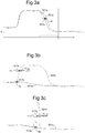
- a step of comparing a first and second 3D model comprises for each point or part of the first 3D model 301a searching for a closest point in the second 3D model 301b and to determine the at least one difference d based on a found closest point in the second 3D model.
- the search is in the illustrated example performed in a radius in relation to the point or part in the first model. In one example, the search is performed in two dimensions. In one example the search is performed in three dimensions. The search is performed within a search radius d max .
- the step of comparing a first and a second 3D model comprises for each point or part of the first 3D model searching for a closest point in the second 3D model to determine at least one first difference value d a for that point or part, for each point or part of the second 3D model searching for a closest point in the first 3D model to determine at least one second difference value d b for that point or part, and to determine the at least one difference value based on the at least one first difference value d a and the at least one second difference value d b .
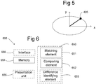
- geometrical information of a first 2D model and/or a second 3D model 401 is defined by a mesh modelling the environment in three dimensions.
- the mesh comprises nodes 402 interconnected by edges 403 and having surfaces 404 boarded by the edges.
- Each node and/or edge and or surface is associated to a 3D coordinate in a geographical coordinate system.
- a plurality of the nodes and/or edges and/or surfaces of the mesh are associated to an attribute.
- the attribute comprises the texture information.
- the attribute comprises in one example also a texture information uncertainty and/or a geometrical information uncertainty.
- a geometrical information uncertainty and/or texture information uncertainty comprises a value for the uncertainty in at least two directions.
- the geometrical information uncertainty and/or texture information uncertainty comprises in one additional or alternative example at least one value related to a distance and/or at least one probability value.
- an arrangement 600 for identifying a difference between a first 3D model 101a of an environment and a second 3D model 101b of the environment is illustrated.
- the arrangement 600 comprises a memory 654 for having access to the first and second 3D model.
- the memory is arranged to temporarily store relevant parts of the first and second model.
- the arrangement comprises means for having access to the first and second 3D model.
- the first and second 3D model is stored in a database.
- the first and second 3D model are stored at one or more remote locations and the means for having access to the first and second 3D model are arranged to supply the first and second 3D model via a network to the arrangement.
- the first and second 3D model are supplied via wireless communication.
- first and second 3D model are supplied via wired communication.
- the access to the first and second model is in one example provided by means of an interface 656.
- the first and second 3D model each comprises a plurality of points or parts. Each point or part of the first and second models comprises geometrical information and texture information.
- the memory comprises the first and second 3D model.
- the memory 654 or means for having access to the first and second 3D model is arranged to store an uncertainty for the geometrical information, which uncertainty is associated to each point or part of the respective 3D model, and it is arranged to store an uncertainty for the texture information, which uncertainty is associated to each point or part of the respective model.
- the arrangement 600 further comprises a processing element 650.
- the processing element 650 is arranged to match corresponding points or parts of the first and second 3D models based on the geometrical information and/or the texture information. This is in one example performed in a matching element 651
- the processing element 650 is further arranged to compare the matched points or parts of the first and second model to determine at least one difference value based on the geometrical information and the texture information of the first and second model.
- the comparing is in one example performed in a comparing element 652.
- the processing element 650 is in one example arranged to identify a difference between the first and second model if the at least one difference value exceeds a predetermined value.
- the processing element 650 is arranged to identify a difference between the first and second models for each point or part based on the determined at least one difference value and based on the geometrical information uncertainty for the respective model and/or the texture information uncertainty for the respective model. This is in one example performed in a difference identifying element 653.
- the processing element 650 is formed as one or more processing units. In one example the processing element 650 is several processing units. In one example the processing units are located at remote locations and arranged to communicate with each other.
- processing element 650 is further arranged to classify an identified difference between the first and second model.
- the classification comprises determining whether the identified difference is caused by natural variations.
- the processing element 650 comprises in one example a computer program comprising a program code for executing the identifying of a difference between a first 3D model of an environment and a second 3D model of the environment.
- the arrangement 600 further comprises a presentation unit 655.
- the presentation unit is arranged to present information related to the part or points of the the first and/or second 3D model for which a difference has been identified.
- the presentation unit is a display.
- the presentation unit is a screen.
- the presentation unit is a printer.
- the presentation unit is a projector.
- the presentation unit is arranged to receive information from the processing element.
Landscapes
- Engineering & Computer Science (AREA)
- Physics & Mathematics (AREA)
- Theoretical Computer Science (AREA)
- General Physics & Mathematics (AREA)
- Computer Vision & Pattern Recognition (AREA)
- Multimedia (AREA)
- Software Systems (AREA)
- Remote Sensing (AREA)
- Evolutionary Computation (AREA)
- Artificial Intelligence (AREA)
- Geometry (AREA)
- Databases & Information Systems (AREA)
- Health & Medical Sciences (AREA)
- Medical Informatics (AREA)
- General Health & Medical Sciences (AREA)
- Astronomy & Astrophysics (AREA)
- Computing Systems (AREA)
- Data Mining & Analysis (AREA)
- Computer Graphics (AREA)
- General Engineering & Computer Science (AREA)
- Bioinformatics & Computational Biology (AREA)
- Life Sciences & Earth Sciences (AREA)
- Evolutionary Biology (AREA)
- Bioinformatics & Cheminformatics (AREA)
- Processing Or Creating Images (AREA)
- Image Generation (AREA)
- Image Processing (AREA)
- Image Analysis (AREA)
Claims (8)
- Verfahren (200) zum Identifizieren einer Differenz zwischen einem ersten 3D-Modell (101a) einer Umgebung und mindestens einem zweiten 3D-Modell (101b) der Umgebung, wobei das erste und zweite 3D-Modell jeweils eine Vielzahl von Punkten oder Teilen umfassen, wobei jeder Punkt oder Teil des ersten und zweiten Modells geometrische Informationen und Texturinformationen umfasst, wobei das Verfahren die folgenden Schritte umfasst:Abgleichen (210) korrespondierender Punkte oder Teile des ersten und zweiten 3D-Modells anhand der geometrischen Informationen und/oder der Texturinformationen, undVergleichen (220) der abgeglichenen Punkte oder Teile des ersten und zweiten Modells, um mindestens einen Differenzwert anhand der geometrischen Informationen und der Texturinformationen des ersten und zweiten Modells zu bestimmen,dadurch gekennzeichnet, dass jedem Punkt oder Teil des jeweiligen 3D-Modells eine Messunsicherheit für die geometrischen Informationen zugeordnet wird und/oder wobei jedem Punkt oder Teil des jeweiligen Modells eine Messunsicherheit für die Texturinformationen zugeordnet wird, ferner umfassend einen Schritt des Identifizierens (230) einer Differenz zwischen dem ersten und zweiten Modell für jeden Punkt oder Teil anhand des mindestens einen bestimmten Differenzwerts und anhand der Messunsicherheit der geometrischen Informationen für das jeweilige Modell und/oder der Messunsicherheit der Texturinformationen für das jeweilige Modell,wobei der Schritt des Vergleichens des ersten und zweiten 3D-Modells ferner Folgendes umfasst:für jeden Punkt oder Teil des ersten 3D-Modells, Suchen nach einem nächstgelegenen Punkt in dem zweiten 3D-Modell, um mindestens einen ersten Differenzwert für diesen Punkt oder Teil zu bestimmen;für jeden Punkt oder Teil des zweiten 3D-Modells, Suchen nach einem nächstgelegenen Punkt in dem ersten 3D-Modell, um mindestens einen zweiten Differenzwert für diesen Punkt oder Teil zu bestimmen; undBestimmen des mindestens einen Differenzwerts anhand des mindestens einen ersten Differenzwerts und des mindestens einen zweiten Differenzwerts.
- Verfahren nach Anspruch 1, wobei die Messunsicherheit der geometrischen Informationen an jedem Punkt oder Teil auf einer lokalen Geometrie des 3D-Modells an diesem Punkt oder Teil basiert.
- Verfahren nach Anspruch 2, wobei die Messunsicherheit der geometrischen Informationen einen Wert für die Messunsicherheit in mindestens zwei Richtungen und/oder mindestens einen Wert in Bezug auf einen Abstand und/oder mindestens einen Wahrscheinlichkeitswert umfasst.
- Verfahren nach einem der vorstehenden Ansprüche, wobei die Texturinformationen Farbinformationen und/oder Graustufeninformationen umfassen.
- Verfahren nach einem der vorstehenden Ansprüche, ferner umfassend einen Schritt des Klassifizierens (240) einer identifizierten Differenz, der das Bestimmen, ob die identifizierte Differenz durch natürliche Variationen verursacht wird, umfasst.
- Verfahren nach Anspruch 5, wobei die Bestimmung, ob die identifizierte Differenz durch natürliche Variationen verursacht wird, auf zu dem jeweiligen 3D-Modell gehörigen Attributinformationen oder Messungen, auf denen das jeweilige Modell basiert, basiert, wobei die Attributinformationen mindestens eines von Folgenden umfassen: Jahreszeit, Tageszeit, Auflösung, aus welcher Quelle das 3D-Modell oder die Messung stammt, in welchen Farben Bilder aufgenommen sind.
- Computerprogrammprodukt, umfassend einen auf einem computerlesbaren Medium gespeicherten Programmcode zum Ausführen des Verfahrens zum Identifizieren einer Differenz zwischen einem ersten 3D-Modell einer Umgebung und einem zweiten 3D-Modell der Umgebung nach einem der Ansprüche 1-6.
- Anordnung (600) zum Identifizieren einer Differenz zwischen einem ersten 3D-Modell (101a) einer Umgebung und einem zweiten 3D-Modell (101b) der Umgebung, wobei die Anordnung Folgendes umfasst:- einen Speicher (654) oder Mittel zum Zugriff auf das erste und zweite 3D-Modell, wobei das erste und zweite 3D-Modell jeweils eine Vielzahl von Punkten oder Teilen umfasst, wobei jeder Punkt oder Teil des ersten und zweiten Modells geometrische Informationen und Texturinformationen umfasst; und- ein Verarbeitungselement (650), das angeordnet ist, um korrespondierende Punkte oder Teile des ersten und zweiten 3D-Modells anhand der geometrischen Informationen und/oder der Texturinformationen abzugleichen und die abgeglichenen Punkte oder Teile des ersten und zweiten Modells zu vergleichen, um mindestens einen Differenzwert anhand der geometrischen Informationen und der Texturinformationen des ersten und zweiten Modells zu bestimmen,- dadurch gekennzeichnet, dass der Speicher (654) oder das Mittel zum Zugreifen auf das erste und zweite 3D-Modell dafür ausgelegt ist, eine jedem Punkt oder Teil des jeweiligen 3D-Modells zugeordnete Messunsicherheit für die geometrischen Informationen zu speichern, und/oder der Speicher (654) oder das Mittel zum Zugreifen auf das erste und zweite 3D-Modell dafür ausgelegt ist, eine jedem Punkt oder Teil des jeweiligen Modells zugeordnete Messunsicherheit für die Texturinformationen zu speichern, und- wobei das Verarbeitungselement (650) ferner angeordnet ist, um eine Differenz zwischen dem ersten und zweiten Modell für jeden Punkt oder Teil anhand des bestimmten mindestens einen Differenzwerts und anhand der Messunsicherheit der geometrischen Informationen für das jeweilige Modell und/oder der Messunsicherheit der Texturinformationen für das jeweilige 3D-Modell zu identifizieren; und- wobei das Verarbeitungselement (650) ferner dafür ausgelegt ist, beim Vergleichen des ersten und zweiten Modells für jeden Punkt oder Teil des ersten 3D-Modells nach einem nächstgelegenen Punkt in dem zweiten 3D-Modell zu suchen, um mindestens einen ersten Differenzwert für diesen Punkt oder Teil zu bestimmen, für jeden Punkt oder Teil des zweiten 3D-Modells nach einem nächstgelegenen Punkt in dem ersten 3D-Modell zu suchen, um mindestens einen zweiten Differenzwert für diesen Punkt oder Teil zu bestimmen, und den mindestens einen Differenzwert anhand des mindestens einen ersten Differenzwerts und des mindestens einen zweiten Differenzwerts zu bestimmen.
Priority Applications (2)
| Application Number | Priority Date | Filing Date | Title |
|---|---|---|---|
| PL14165561T PL2911090T3 (pl) | 2014-02-24 | 2014-04-23 | Sposób i układ do identyfikowania różnicy między pierwszym modelem trójwymiarowym otoczenia a drugim modelem trójwymiarowym otoczenia |
| EP18208356.8A EP3477546A1 (de) | 2014-02-24 | 2014-04-23 | Verfahren und anordnung zur identifizierung einer differenz zwischen einem ersten 3d-modell einer umgebung und einem zweiten 3d-modell der umgebung |
Applications Claiming Priority (1)
| Application Number | Priority Date | Filing Date | Title |
|---|---|---|---|
| US14/188,314 US9460520B2 (en) | 2014-02-24 | 2014-02-24 | Method and arrangement for identifying a difference between a first 3D model of an environment and a second 3D model of the environment |
Related Child Applications (2)
| Application Number | Title | Priority Date | Filing Date |
|---|---|---|---|
| EP18208356.8A Division EP3477546A1 (de) | 2014-02-24 | 2014-04-23 | Verfahren und anordnung zur identifizierung einer differenz zwischen einem ersten 3d-modell einer umgebung und einem zweiten 3d-modell der umgebung |
| EP18208356.8A Previously-Filed-Application EP3477546A1 (de) | 2014-02-24 | 2014-04-23 | Verfahren und anordnung zur identifizierung einer differenz zwischen einem ersten 3d-modell einer umgebung und einem zweiten 3d-modell der umgebung |
Publications (2)
| Publication Number | Publication Date |
|---|---|
| EP2911090A1 EP2911090A1 (de) | 2015-08-26 |
| EP2911090B1 true EP2911090B1 (de) | 2018-11-28 |
Family
ID=50846758
Family Applications (2)
| Application Number | Title | Priority Date | Filing Date |
|---|---|---|---|
| EP14165561.3A Active EP2911090B1 (de) | 2014-02-24 | 2014-04-23 | Verfahren und Anordnung zur Identifizierung einer Differenz zwischen einem ersten 3D-Modell einer Umgebung und einem zweiten 3D-Modell der Umgebung |
| EP18208356.8A Pending EP3477546A1 (de) | 2014-02-24 | 2014-04-23 | Verfahren und anordnung zur identifizierung einer differenz zwischen einem ersten 3d-modell einer umgebung und einem zweiten 3d-modell der umgebung |
Family Applications After (1)
| Application Number | Title | Priority Date | Filing Date |
|---|---|---|---|
| EP18208356.8A Pending EP3477546A1 (de) | 2014-02-24 | 2014-04-23 | Verfahren und anordnung zur identifizierung einer differenz zwischen einem ersten 3d-modell einer umgebung und einem zweiten 3d-modell der umgebung |
Country Status (5)
| Country | Link |
|---|---|
| US (2) | US9460520B2 (de) |
| EP (2) | EP2911090B1 (de) |
| ES (1) | ES2712202T3 (de) |
| PL (1) | PL2911090T3 (de) |
| TR (1) | TR201901067T4 (de) |
Families Citing this family (10)
| Publication number | Priority date | Publication date | Assignee | Title |
|---|---|---|---|---|
| US9460520B2 (en) | 2014-02-24 | 2016-10-04 | Vricon Systems Ab | Method and arrangement for identifying a difference between a first 3D model of an environment and a second 3D model of the environment |
| US10489971B2 (en) * | 2015-06-17 | 2019-11-26 | Rosemount Aerospace Inc. | System and method for processing captured images for moving platform navigation |
| CN109871761A (zh) * | 2019-01-16 | 2019-06-11 | 中德(珠海)人工智能研究院有限公司 | 一种三维模型的识别系统 |
| US10964098B1 (en) * | 2019-03-05 | 2021-03-30 | Facebook Technologies, Llc | Inverse path tracing for material and lighting estimation |
| EP3936816A4 (de) * | 2019-03-05 | 2022-05-04 | Panasonic Intellectual Property Management Co., Ltd. | Verfahren zur verschiebungsdetektion, fotografisches anweisungsverfahren, vorrichtung zur verschiebungsdetektion und fotografische anweisungsvorrichtung |
| CN110599594B (zh) * | 2019-07-29 | 2021-07-20 | 成都理工大学 | 一种岩石物性结构三维建模的方法 |
| CN111161252B (zh) * | 2019-12-31 | 2022-03-25 | 山东大学 | 岩体结构探测及危石探测系统及方法 |
| EP4036859A1 (de) * | 2021-01-27 | 2022-08-03 | Maxar International Sweden AB | System und verfahren zur bereitstellung von verbesserten geocodierten referenzdaten an eine 3d-kartendarstellung |
| GB2604927B (en) * | 2021-03-19 | 2023-12-20 | Imperial College Innovations Ltd | Modelling an environment using image data |
| SE2351501A1 (en) * | 2023-12-22 | 2025-06-23 | Maxar Int Sweden Ab | Methods, systems and computer programs for relative depth map image generation |
Family Cites Families (17)
| Publication number | Priority date | Publication date | Assignee | Title |
|---|---|---|---|---|
| JP4341135B2 (ja) | 2000-03-10 | 2009-10-07 | コニカミノルタホールディングス株式会社 | 物体認識装置 |
| KR20020054243A (ko) * | 2000-12-27 | 2002-07-06 | 오길록 | 다중 영상을 이용한 대화형 모델 생성 장치 및 그 방법 |
| US7239311B2 (en) * | 2002-09-26 | 2007-07-03 | The United States Government As Represented By The Secretary Of The Navy | Global visualization process (GVP) and system for implementing a GVP |
| US8160296B2 (en) | 2005-04-15 | 2012-04-17 | Mississippi State University Research And Technology Corporation | Change analyst |
| JP4339289B2 (ja) | 2005-07-28 | 2009-10-07 | Necシステムテクノロジー株式会社 | 変化判定装置、変化判定方法および変化判定プログラム |
| US7712052B2 (en) * | 2006-07-31 | 2010-05-04 | Microsoft Corporation | Applications of three-dimensional environments constructed from images |
| US20090010507A1 (en) * | 2007-07-02 | 2009-01-08 | Zheng Jason Geng | System and method for generating a 3d model of anatomical structure using a plurality of 2d images |
| US9094673B2 (en) | 2007-07-04 | 2015-07-28 | Saab Ab | Arrangement and method for providing a three dimensional map representation of an area |
| US8244026B2 (en) | 2008-01-09 | 2012-08-14 | Tiltan Systems Engineering Ltd. | Apparatus and method for automatic airborne LiDAR data processing and mapping using data obtained thereby |
| TW201022708A (en) * | 2008-12-11 | 2010-06-16 | Univ Nat Central | Method of change detection for building models |
| US8620093B2 (en) | 2010-03-15 | 2013-12-31 | The United States Of America As Represented By The Secretary Of The Army | Method and system for image registration and change detection |
| US8452081B2 (en) * | 2011-01-11 | 2013-05-28 | Eastman Kodak Company | Forming 3D models using multiple images |
| US9041711B1 (en) * | 2012-05-08 | 2015-05-26 | Google Inc. | Generating reduced resolution textured model from higher resolution model |
| US9208606B2 (en) | 2012-08-22 | 2015-12-08 | Nvidia Corporation | System, method, and computer program product for extruding a model through a two-dimensional scene |
| US8633970B1 (en) * | 2012-08-30 | 2014-01-21 | Google Inc. | Augmented reality with earth data |
| US9171402B1 (en) * | 2013-06-19 | 2015-10-27 | Google Inc. | View-dependent textures for interactive geographic information system |
| US9460520B2 (en) | 2014-02-24 | 2016-10-04 | Vricon Systems Ab | Method and arrangement for identifying a difference between a first 3D model of an environment and a second 3D model of the environment |
-
2014
- 2014-02-24 US US14/188,314 patent/US9460520B2/en active Active
- 2014-04-23 TR TR2019/01067T patent/TR201901067T4/tr unknown
- 2014-04-23 EP EP14165561.3A patent/EP2911090B1/de active Active
- 2014-04-23 EP EP18208356.8A patent/EP3477546A1/de active Pending
- 2014-04-23 PL PL14165561T patent/PL2911090T3/pl unknown
- 2014-04-23 ES ES14165561T patent/ES2712202T3/es active Active
-
2016
- 2016-03-10 US US15/066,511 patent/US9489563B2/en active Active
Non-Patent Citations (1)
| Title |
|---|
| None * |
Also Published As
| Publication number | Publication date |
|---|---|
| EP2911090A1 (de) | 2015-08-26 |
| US20160188957A1 (en) | 2016-06-30 |
| TR201901067T4 (tr) | 2019-02-21 |
| US20150243047A1 (en) | 2015-08-27 |
| PL2911090T3 (pl) | 2019-05-31 |
| ES2712202T3 (es) | 2019-05-09 |
| US9489563B2 (en) | 2016-11-08 |
| EP3477546A1 (de) | 2019-05-01 |
| US9460520B2 (en) | 2016-10-04 |
Similar Documents
| Publication | Publication Date | Title |
|---|---|---|
| US9489563B2 (en) | Method and arrangement for identifying a difference between a first 3D model of an environment and a second 3D model of the environment | |
| Wieland et al. | Estimating building inventory for rapid seismic vulnerability assessment: Towards an integrated approach based on multi-source imaging | |
| CN109598794B (zh) | 三维gis动态模型的构建方法 | |
| KR101404655B1 (ko) | 레이저 레이더의 3차원 원시 데이터의 고유값 비율을 이용한 송전선 추출 방법 | |
| US12361707B1 (en) | System and method for discriminating and demarcating targets of interest in a physical scene | |
| CN117501322B (zh) | 从点云数据生成物理空间的映射 | |
| JP7418281B2 (ja) | 地物の分類システム、分類方法及びそのプログラム | |
| Champion et al. | 2D building change detection from high resolution satelliteimagery: A two-step hierarchical method based on 3D invariant primitives | |
| EP3376160A1 (de) | Verfahren und system zur identifizierung von städtischen objekten | |
| CN115861816A (zh) | 一种立体低涡识别方法、装置、存储介质及终端 | |
| KR20180092591A (ko) | Uav 영상매칭 기술을 이용한 구조물 형상변화 탐지 알고리즘 | |
| Samadzadegan et al. | Automatic road crack recognition based on deep learning networks from UAV imagery | |
| Kerle et al. | Urban structural damage assessment with oblique UAV imagery, object-based image analysis and semantic reasoning | |
| WO2018151629A1 (ru) | Способ и система автоматического построения трехмерных моделей городов | |
| Chen et al. | Indoor view-based visibility analysis using UAV and TLS point clouds with Line-of-Sight correction | |
| EP3070459A1 (de) | Inspektionszielobjektextraktionsvorrichtung und inspektionszielobjektextraktionsverfahren | |
| KR101586568B1 (ko) | 3차원 지도 구축을 위한 스테레오 카메라 설계 방법 및 그 장치 | |
| Gonçalves et al. | Planar projection of mobile laser scanning data in tunnels | |
| CN116580168A (zh) | 建筑物白模的构建方法、装置、设备和存储介质 | |
| Voltersen et al. | Expanding an urban structure type mapping approach from a subarea to the entire city of Berlin | |
| D'Auria et al. | Surveys and New Visions of the Ancient Centre of Naples | |
| CN121033714B (zh) | 基于无人机图像采集的桥梁工程异常识别方法及系统 | |
| Zhang et al. | Hierarchical repetition extraction for building façade reconstruction from oblique aerial images | |
| Disser | SPARK: a universal approach to 3D point cloud segmentation using 2D image segmentation models–cemonstration on traffic objects | |
| do Rosário Vong | Digital Multispectral Map Reconstruction Using Aerial Imagery |
Legal Events
| Date | Code | Title | Description |
|---|---|---|---|
| PUAI | Public reference made under article 153(3) epc to a published international application that has entered the european phase |
Free format text: ORIGINAL CODE: 0009012 |
|
| AK | Designated contracting states |
Kind code of ref document: A1 Designated state(s): AL AT BE BG CH CY CZ DE DK EE ES FI FR GB GR HR HU IE IS IT LI LT LU LV MC MK MT NL NO PL PT RO RS SE SI SK SM TR |
|
| AX | Request for extension of the european patent |
Extension state: BA ME |
|
| RAP1 | Party data changed (applicant data changed or rights of an application transferred) |
Owner name: VRICON SYSTEMS AB |
|
| 17P | Request for examination filed |
Effective date: 20160201 |
|
| RBV | Designated contracting states (corrected) |
Designated state(s): AL AT BE BG CH CY CZ DE DK EE ES FI FR GB GR HR HU IE IS IT LI LT LU LV MC MK MT NL NO PL PT RO RS SE SI SK SM TR |
|
| STAA | Information on the status of an ep patent application or granted ep patent |
Free format text: STATUS: EXAMINATION IS IN PROGRESS |
|
| 17Q | First examination report despatched |
Effective date: 20170322 |
|
| GRAP | Despatch of communication of intention to grant a patent |
Free format text: ORIGINAL CODE: EPIDOSNIGR1 |
|
| STAA | Information on the status of an ep patent application or granted ep patent |
Free format text: STATUS: GRANT OF PATENT IS INTENDED |
|
| INTG | Intention to grant announced |
Effective date: 20180625 |
|
| GRAS | Grant fee paid |
Free format text: ORIGINAL CODE: EPIDOSNIGR3 |
|
| GRAA | (expected) grant |
Free format text: ORIGINAL CODE: 0009210 |
|
| STAA | Information on the status of an ep patent application or granted ep patent |
Free format text: STATUS: THE PATENT HAS BEEN GRANTED |
|
| AK | Designated contracting states |
Kind code of ref document: B1 Designated state(s): AL AT BE BG CH CY CZ DE DK EE ES FI FR GB GR HR HU IE IS IT LI LT LU LV MC MK MT NL NO PL PT RO RS SE SI SK SM TR |
|
| REG | Reference to a national code |
Ref country code: CH Ref legal event code: EP |
|
| REG | Reference to a national code |
Ref country code: AT Ref legal event code: REF Ref document number: 1071083 Country of ref document: AT Kind code of ref document: T Effective date: 20181215 |
|
| REG | Reference to a national code |
Ref country code: DE Ref legal event code: R096 Ref document number: 602014036797 Country of ref document: DE |
|
| REG | Reference to a national code |
Ref country code: IE Ref legal event code: FG4D |
|
| REG | Reference to a national code |
Ref country code: SE Ref legal event code: TRGR |
|
| REG | Reference to a national code |
Ref country code: NL Ref legal event code: MP Effective date: 20181128 |
|
| REG | Reference to a national code |
Ref country code: LT Ref legal event code: MG4D |
|
| REG | Reference to a national code |
Ref country code: AT Ref legal event code: MK05 Ref document number: 1071083 Country of ref document: AT Kind code of ref document: T Effective date: 20181128 |
|
| PG25 | Lapsed in a contracting state [announced via postgrant information from national office to epo] |
Ref country code: IS Free format text: LAPSE BECAUSE OF FAILURE TO SUBMIT A TRANSLATION OF THE DESCRIPTION OR TO PAY THE FEE WITHIN THE PRESCRIBED TIME-LIMIT Effective date: 20190328 Ref country code: HR Free format text: LAPSE BECAUSE OF FAILURE TO SUBMIT A TRANSLATION OF THE DESCRIPTION OR TO PAY THE FEE WITHIN THE PRESCRIBED TIME-LIMIT Effective date: 20181128 Ref country code: NO Free format text: LAPSE BECAUSE OF FAILURE TO SUBMIT A TRANSLATION OF THE DESCRIPTION OR TO PAY THE FEE WITHIN THE PRESCRIBED TIME-LIMIT Effective date: 20190228 Ref country code: BG Free format text: LAPSE BECAUSE OF FAILURE TO SUBMIT A TRANSLATION OF THE DESCRIPTION OR TO PAY THE FEE WITHIN THE PRESCRIBED TIME-LIMIT Effective date: 20190228 Ref country code: LT Free format text: LAPSE BECAUSE OF FAILURE TO SUBMIT A TRANSLATION OF THE DESCRIPTION OR TO PAY THE FEE WITHIN THE PRESCRIBED TIME-LIMIT Effective date: 20181128 Ref country code: LV Free format text: LAPSE BECAUSE OF FAILURE TO SUBMIT A TRANSLATION OF THE DESCRIPTION OR TO PAY THE FEE WITHIN THE PRESCRIBED TIME-LIMIT Effective date: 20181128 Ref country code: AT Free format text: LAPSE BECAUSE OF FAILURE TO SUBMIT A TRANSLATION OF THE DESCRIPTION OR TO PAY THE FEE WITHIN THE PRESCRIBED TIME-LIMIT Effective date: 20181128 Ref country code: FI Free format text: LAPSE BECAUSE OF FAILURE TO SUBMIT A TRANSLATION OF THE DESCRIPTION OR TO PAY THE FEE WITHIN THE PRESCRIBED TIME-LIMIT Effective date: 20181128 |
|
| REG | Reference to a national code |
Ref country code: ES Ref legal event code: FG2A Ref document number: 2712202 Country of ref document: ES Kind code of ref document: T3 Effective date: 20190509 |
|
| PG25 | Lapsed in a contracting state [announced via postgrant information from national office to epo] |
Ref country code: PT Free format text: LAPSE BECAUSE OF FAILURE TO SUBMIT A TRANSLATION OF THE DESCRIPTION OR TO PAY THE FEE WITHIN THE PRESCRIBED TIME-LIMIT Effective date: 20190328 Ref country code: GR Free format text: LAPSE BECAUSE OF FAILURE TO SUBMIT A TRANSLATION OF THE DESCRIPTION OR TO PAY THE FEE WITHIN THE PRESCRIBED TIME-LIMIT Effective date: 20190301 Ref country code: AL Free format text: LAPSE BECAUSE OF FAILURE TO SUBMIT A TRANSLATION OF THE DESCRIPTION OR TO PAY THE FEE WITHIN THE PRESCRIBED TIME-LIMIT Effective date: 20181128 Ref country code: RS Free format text: LAPSE BECAUSE OF FAILURE TO SUBMIT A TRANSLATION OF THE DESCRIPTION OR TO PAY THE FEE WITHIN THE PRESCRIBED TIME-LIMIT Effective date: 20181128 |
|
| PG25 | Lapsed in a contracting state [announced via postgrant information from national office to epo] |
Ref country code: NL Free format text: LAPSE BECAUSE OF FAILURE TO SUBMIT A TRANSLATION OF THE DESCRIPTION OR TO PAY THE FEE WITHIN THE PRESCRIBED TIME-LIMIT Effective date: 20181128 |
|
| PG25 | Lapsed in a contracting state [announced via postgrant information from national office to epo] |
Ref country code: DK Free format text: LAPSE BECAUSE OF FAILURE TO SUBMIT A TRANSLATION OF THE DESCRIPTION OR TO PAY THE FEE WITHIN THE PRESCRIBED TIME-LIMIT Effective date: 20181128 Ref country code: CZ Free format text: LAPSE BECAUSE OF FAILURE TO SUBMIT A TRANSLATION OF THE DESCRIPTION OR TO PAY THE FEE WITHIN THE PRESCRIBED TIME-LIMIT Effective date: 20181128 |
|
| REG | Reference to a national code |
Ref country code: DE Ref legal event code: R097 Ref document number: 602014036797 Country of ref document: DE |
|
| PG25 | Lapsed in a contracting state [announced via postgrant information from national office to epo] |
Ref country code: RO Free format text: LAPSE BECAUSE OF FAILURE TO SUBMIT A TRANSLATION OF THE DESCRIPTION OR TO PAY THE FEE WITHIN THE PRESCRIBED TIME-LIMIT Effective date: 20181128 Ref country code: SK Free format text: LAPSE BECAUSE OF FAILURE TO SUBMIT A TRANSLATION OF THE DESCRIPTION OR TO PAY THE FEE WITHIN THE PRESCRIBED TIME-LIMIT Effective date: 20181128 Ref country code: EE Free format text: LAPSE BECAUSE OF FAILURE TO SUBMIT A TRANSLATION OF THE DESCRIPTION OR TO PAY THE FEE WITHIN THE PRESCRIBED TIME-LIMIT Effective date: 20181128 Ref country code: SM Free format text: LAPSE BECAUSE OF FAILURE TO SUBMIT A TRANSLATION OF THE DESCRIPTION OR TO PAY THE FEE WITHIN THE PRESCRIBED TIME-LIMIT Effective date: 20181128 |
|
| PLBE | No opposition filed within time limit |
Free format text: ORIGINAL CODE: 0009261 |
|
| STAA | Information on the status of an ep patent application or granted ep patent |
Free format text: STATUS: NO OPPOSITION FILED WITHIN TIME LIMIT |
|
| PG25 | Lapsed in a contracting state [announced via postgrant information from national office to epo] |
Ref country code: SI Free format text: LAPSE BECAUSE OF FAILURE TO SUBMIT A TRANSLATION OF THE DESCRIPTION OR TO PAY THE FEE WITHIN THE PRESCRIBED TIME-LIMIT Effective date: 20181128 |
|
| 26N | No opposition filed |
Effective date: 20190829 |
|
| REG | Reference to a national code |
Ref country code: CH Ref legal event code: PL |
|
| REG | Reference to a national code |
Ref country code: BE Ref legal event code: MM Effective date: 20190430 |
|
| PG25 | Lapsed in a contracting state [announced via postgrant information from national office to epo] |
Ref country code: LU Free format text: LAPSE BECAUSE OF NON-PAYMENT OF DUE FEES Effective date: 20190423 Ref country code: MC Free format text: LAPSE BECAUSE OF FAILURE TO SUBMIT A TRANSLATION OF THE DESCRIPTION OR TO PAY THE FEE WITHIN THE PRESCRIBED TIME-LIMIT Effective date: 20181128 |
|
| PG25 | Lapsed in a contracting state [announced via postgrant information from national office to epo] |
Ref country code: LI Free format text: LAPSE BECAUSE OF NON-PAYMENT OF DUE FEES Effective date: 20190430 Ref country code: CH Free format text: LAPSE BECAUSE OF NON-PAYMENT OF DUE FEES Effective date: 20190430 |
|
| PG25 | Lapsed in a contracting state [announced via postgrant information from national office to epo] |
Ref country code: BE Free format text: LAPSE BECAUSE OF NON-PAYMENT OF DUE FEES Effective date: 20190430 |
|
| PG25 | Lapsed in a contracting state [announced via postgrant information from national office to epo] |
Ref country code: IE Free format text: LAPSE BECAUSE OF NON-PAYMENT OF DUE FEES Effective date: 20190423 |
|
| PG25 | Lapsed in a contracting state [announced via postgrant information from national office to epo] |
Ref country code: CY Free format text: LAPSE BECAUSE OF FAILURE TO SUBMIT A TRANSLATION OF THE DESCRIPTION OR TO PAY THE FEE WITHIN THE PRESCRIBED TIME-LIMIT Effective date: 20181128 |
|
| PG25 | Lapsed in a contracting state [announced via postgrant information from national office to epo] |
Ref country code: MT Free format text: LAPSE BECAUSE OF FAILURE TO SUBMIT A TRANSLATION OF THE DESCRIPTION OR TO PAY THE FEE WITHIN THE PRESCRIBED TIME-LIMIT Effective date: 20181128 Ref country code: HU Free format text: LAPSE BECAUSE OF FAILURE TO SUBMIT A TRANSLATION OF THE DESCRIPTION OR TO PAY THE FEE WITHIN THE PRESCRIBED TIME-LIMIT; INVALID AB INITIO Effective date: 20140423 |
|
| REG | Reference to a national code |
Ref country code: DE Ref legal event code: R079 Ref document number: 602014036797 Country of ref document: DE Free format text: PREVIOUS MAIN CLASS: G06K0009000000 Ipc: G06V0010000000 |
|
| REG | Reference to a national code |
Ref country code: DE Ref legal event code: R081 Ref document number: 602014036797 Country of ref document: DE Owner name: MAXAR INTERNATIONAL SWEDEN AB, SE Free format text: FORMER OWNER: VRICON SYSTEMS AB, LINKOEPING, SE Ref country code: DE Ref legal event code: R081 Ref document number: 602014036797 Country of ref document: DE Owner name: VANTOR SWEDEN AB, SE Free format text: FORMER OWNER: VRICON SYSTEMS AB, LINKOEPING, SE |
|
| PG25 | Lapsed in a contracting state [announced via postgrant information from national office to epo] |
Ref country code: MK Free format text: LAPSE BECAUSE OF FAILURE TO SUBMIT A TRANSLATION OF THE DESCRIPTION OR TO PAY THE FEE WITHIN THE PRESCRIBED TIME-LIMIT Effective date: 20181128 |
|
| REG | Reference to a national code |
Ref country code: ES Ref legal event code: PC2A Owner name: MAXAR INTERNATIONAL SWEDEN AB Effective date: 20230127 |
|
| P01 | Opt-out of the competence of the unified patent court (upc) registered |
Effective date: 20230526 |
|
| PGFP | Annual fee paid to national office [announced via postgrant information from national office to epo] |
Ref country code: DE Payment date: 20250428 Year of fee payment: 12 |
|
| PGFP | Annual fee paid to national office [announced via postgrant information from national office to epo] |
Ref country code: GB Payment date: 20250422 Year of fee payment: 12 Ref country code: ES Payment date: 20250513 Year of fee payment: 12 |
|
| PGFP | Annual fee paid to national office [announced via postgrant information from national office to epo] |
Ref country code: IT Payment date: 20250422 Year of fee payment: 12 |
|
| PGFP | Annual fee paid to national office [announced via postgrant information from national office to epo] |
Ref country code: FR Payment date: 20250424 Year of fee payment: 12 |
|
| PGFP | Annual fee paid to national office [announced via postgrant information from national office to epo] |
Ref country code: TR Payment date: 20250407 Year of fee payment: 12 |
|
| PGFP | Annual fee paid to national office [announced via postgrant information from national office to epo] |
Ref country code: SE Payment date: 20250424 Year of fee payment: 12 |
|
| REG | Reference to a national code |
Ref country code: DE Ref legal event code: R081 Ref document number: 602014036797 Country of ref document: DE Owner name: VANTOR SWEDEN AB, SE Free format text: FORMER OWNER: MAXAR INTERNATIONAL SWEDEN AB, LINKOEPING, SE |
|
| PGFP | Annual fee paid to national office [announced via postgrant information from national office to epo] |
Ref country code: PL Payment date: 20260330 Year of fee payment: 13 |