EP2889581A1 - Navigation terminal, navigation method and remote navigation service system - Google Patents
Navigation terminal, navigation method and remote navigation service system Download PDFInfo
- Publication number
- EP2889581A1 EP2889581A1 EP13839553.8A EP13839553A EP2889581A1 EP 2889581 A1 EP2889581 A1 EP 2889581A1 EP 13839553 A EP13839553 A EP 13839553A EP 2889581 A1 EP2889581 A1 EP 2889581A1
- Authority
- EP
- European Patent Office
- Prior art keywords
- navigation
- indication
- vehicle
- service system
- remote
- Prior art date
- Legal status (The legal status is an assumption and is not a legal conclusion. Google has not performed a legal analysis and makes no representation as to the accuracy of the status listed.)
- Withdrawn
Links
- 238000000034 method Methods 0.000 title claims abstract description 17
- 238000004891 communication Methods 0.000 claims abstract description 42
- 238000012544 monitoring process Methods 0.000 claims description 4
- 238000010586 diagram Methods 0.000 description 8
- 230000006870 function Effects 0.000 description 8
- 238000005516 engineering process Methods 0.000 description 4
- 230000003190 augmentative effect Effects 0.000 description 2
- 230000007774 longterm Effects 0.000 description 2
- 238000010295 mobile communication Methods 0.000 description 2
- 238000004458 analytical method Methods 0.000 description 1
- 238000004364 calculation method Methods 0.000 description 1
- 230000000295 complement effect Effects 0.000 description 1
- 238000011161 development Methods 0.000 description 1
- 239000011521 glass Substances 0.000 description 1
- 238000012986 modification Methods 0.000 description 1
- 230000004048 modification Effects 0.000 description 1
- 238000012545 processing Methods 0.000 description 1
- 230000000007 visual effect Effects 0.000 description 1
Images


Classifications
-
- G—PHYSICS
- G01—MEASURING; TESTING
- G01S—RADIO DIRECTION-FINDING; RADIO NAVIGATION; DETERMINING DISTANCE OR VELOCITY BY USE OF RADIO WAVES; LOCATING OR PRESENCE-DETECTING BY USE OF THE REFLECTION OR RERADIATION OF RADIO WAVES; ANALOGOUS ARRANGEMENTS USING OTHER WAVES
- G01S19/00—Satellite radio beacon positioning systems; Determining position, velocity or attitude using signals transmitted by such systems
- G01S19/38—Determining a navigation solution using signals transmitted by a satellite radio beacon positioning system
-
- G—PHYSICS
- G01—MEASURING; TESTING
- G01C—MEASURING DISTANCES, LEVELS OR BEARINGS; SURVEYING; NAVIGATION; GYROSCOPIC INSTRUMENTS; PHOTOGRAMMETRY OR VIDEOGRAMMETRY
- G01C21/00—Navigation; Navigational instruments not provided for in groups G01C1/00 - G01C19/00
- G01C21/26—Navigation; Navigational instruments not provided for in groups G01C1/00 - G01C19/00 specially adapted for navigation in a road network
- G01C21/34—Route searching; Route guidance
-
- B—PERFORMING OPERATIONS; TRANSPORTING
- B60—VEHICLES IN GENERAL
- B60R—VEHICLES, VEHICLE FITTINGS, OR VEHICLE PARTS, NOT OTHERWISE PROVIDED FOR
- B60R1/00—Optical viewing arrangements; Real-time viewing arrangements for drivers or passengers using optical image capturing systems, e.g. cameras or video systems specially adapted for use in or on vehicles
- B60R1/20—Real-time viewing arrangements for drivers or passengers using optical image capturing systems, e.g. cameras or video systems specially adapted for use in or on vehicles
- B60R1/22—Real-time viewing arrangements for drivers or passengers using optical image capturing systems, e.g. cameras or video systems specially adapted for use in or on vehicles for viewing an area outside the vehicle, e.g. the exterior of the vehicle
- B60R1/23—Real-time viewing arrangements for drivers or passengers using optical image capturing systems, e.g. cameras or video systems specially adapted for use in or on vehicles for viewing an area outside the vehicle, e.g. the exterior of the vehicle with a predetermined field of view
- B60R1/24—Real-time viewing arrangements for drivers or passengers using optical image capturing systems, e.g. cameras or video systems specially adapted for use in or on vehicles for viewing an area outside the vehicle, e.g. the exterior of the vehicle with a predetermined field of view in front of the vehicle
-
- G—PHYSICS
- G01—MEASURING; TESTING
- G01C—MEASURING DISTANCES, LEVELS OR BEARINGS; SURVEYING; NAVIGATION; GYROSCOPIC INSTRUMENTS; PHOTOGRAMMETRY OR VIDEOGRAMMETRY
- G01C21/00—Navigation; Navigational instruments not provided for in groups G01C1/00 - G01C19/00
- G01C21/26—Navigation; Navigational instruments not provided for in groups G01C1/00 - G01C19/00 specially adapted for navigation in a road network
- G01C21/265—Navigation; Navigational instruments not provided for in groups G01C1/00 - G01C19/00 specially adapted for navigation in a road network constructional aspects of navigation devices, e.g. housings, mountings, displays
-
- G—PHYSICS
- G01—MEASURING; TESTING
- G01C—MEASURING DISTANCES, LEVELS OR BEARINGS; SURVEYING; NAVIGATION; GYROSCOPIC INSTRUMENTS; PHOTOGRAMMETRY OR VIDEOGRAMMETRY
- G01C21/00—Navigation; Navigational instruments not provided for in groups G01C1/00 - G01C19/00
- G01C21/26—Navigation; Navigational instruments not provided for in groups G01C1/00 - G01C19/00 specially adapted for navigation in a road network
- G01C21/34—Route searching; Route guidance
- G01C21/3453—Special cost functions, i.e. other than distance or default speed limit of road segments
- G01C21/3492—Special cost functions, i.e. other than distance or default speed limit of road segments employing speed data or traffic data, e.g. real-time or historical
-
- G—PHYSICS
- G01—MEASURING; TESTING
- G01C—MEASURING DISTANCES, LEVELS OR BEARINGS; SURVEYING; NAVIGATION; GYROSCOPIC INSTRUMENTS; PHOTOGRAMMETRY OR VIDEOGRAMMETRY
- G01C21/00—Navigation; Navigational instruments not provided for in groups G01C1/00 - G01C19/00
- G01C21/26—Navigation; Navigational instruments not provided for in groups G01C1/00 - G01C19/00 specially adapted for navigation in a road network
- G01C21/34—Route searching; Route guidance
- G01C21/36—Input/output arrangements for on-board computers
- G01C21/3605—Destination input or retrieval
-
- G—PHYSICS
- G01—MEASURING; TESTING
- G01C—MEASURING DISTANCES, LEVELS OR BEARINGS; SURVEYING; NAVIGATION; GYROSCOPIC INSTRUMENTS; PHOTOGRAMMETRY OR VIDEOGRAMMETRY
- G01C21/00—Navigation; Navigational instruments not provided for in groups G01C1/00 - G01C19/00
- G01C21/26—Navigation; Navigational instruments not provided for in groups G01C1/00 - G01C19/00 specially adapted for navigation in a road network
- G01C21/34—Route searching; Route guidance
- G01C21/36—Input/output arrangements for on-board computers
- G01C21/3626—Details of the output of route guidance instructions
- G01C21/3629—Guidance using speech or audio output, e.g. text-to-speech
-
- G—PHYSICS
- G01—MEASURING; TESTING
- G01C—MEASURING DISTANCES, LEVELS OR BEARINGS; SURVEYING; NAVIGATION; GYROSCOPIC INSTRUMENTS; PHOTOGRAMMETRY OR VIDEOGRAMMETRY
- G01C21/00—Navigation; Navigational instruments not provided for in groups G01C1/00 - G01C19/00
- G01C21/26—Navigation; Navigational instruments not provided for in groups G01C1/00 - G01C19/00 specially adapted for navigation in a road network
- G01C21/34—Route searching; Route guidance
- G01C21/36—Input/output arrangements for on-board computers
- G01C21/3626—Details of the output of route guidance instructions
- G01C21/3632—Guidance using simplified or iconic instructions, e.g. using arrows
-
- G—PHYSICS
- G01—MEASURING; TESTING
- G01C—MEASURING DISTANCES, LEVELS OR BEARINGS; SURVEYING; NAVIGATION; GYROSCOPIC INSTRUMENTS; PHOTOGRAMMETRY OR VIDEOGRAMMETRY
- G01C21/00—Navigation; Navigational instruments not provided for in groups G01C1/00 - G01C19/00
- G01C21/26—Navigation; Navigational instruments not provided for in groups G01C1/00 - G01C19/00 specially adapted for navigation in a road network
- G01C21/34—Route searching; Route guidance
- G01C21/36—Input/output arrangements for on-board computers
- G01C21/3626—Details of the output of route guidance instructions
- G01C21/3647—Guidance involving output of stored or live camera images or video streams
-
- G—PHYSICS
- G01—MEASURING; TESTING
- G01C—MEASURING DISTANCES, LEVELS OR BEARINGS; SURVEYING; NAVIGATION; GYROSCOPIC INSTRUMENTS; PHOTOGRAMMETRY OR VIDEOGRAMMETRY
- G01C21/00—Navigation; Navigational instruments not provided for in groups G01C1/00 - G01C19/00
- G01C21/26—Navigation; Navigational instruments not provided for in groups G01C1/00 - G01C19/00 specially adapted for navigation in a road network
- G01C21/34—Route searching; Route guidance
- G01C21/36—Input/output arrangements for on-board computers
- G01C21/3667—Display of a road map
- G01C21/3676—Overview of the route on the road map
-
- B—PERFORMING OPERATIONS; TRANSPORTING
- B60—VEHICLES IN GENERAL
- B60R—VEHICLES, VEHICLE FITTINGS, OR VEHICLE PARTS, NOT OTHERWISE PROVIDED FOR
- B60R2300/00—Details of viewing arrangements using cameras and displays, specially adapted for use in a vehicle
- B60R2300/30—Details of viewing arrangements using cameras and displays, specially adapted for use in a vehicle characterised by the type of image processing
- B60R2300/302—Details of viewing arrangements using cameras and displays, specially adapted for use in a vehicle characterised by the type of image processing combining image information with GPS information or vehicle data, e.g. vehicle speed, gyro, steering angle data
-
- G—PHYSICS
- G01—MEASURING; TESTING
- G01C—MEASURING DISTANCES, LEVELS OR BEARINGS; SURVEYING; NAVIGATION; GYROSCOPIC INSTRUMENTS; PHOTOGRAMMETRY OR VIDEOGRAMMETRY
- G01C21/00—Navigation; Navigational instruments not provided for in groups G01C1/00 - G01C19/00
- G01C21/26—Navigation; Navigational instruments not provided for in groups G01C1/00 - G01C19/00 specially adapted for navigation in a road network
- G01C21/34—Route searching; Route guidance
- G01C21/36—Input/output arrangements for on-board computers
- G01C21/3602—Input other than that of destination using image analysis, e.g. detection of road signs, lanes, buildings, real preceding vehicles using a camera
Definitions
- the present invention relates to a navigation technology, and in particular, to a terminal, a system, and a method that can implement real-time navigation according to a road condition.
- an objective of the present invention is to provide a real-time navigation service system and a navigation terminal, so as to provide a quick and real-time navigation service.
- a navigation terminal is connected to and communicates with a remote navigation service system, where the navigation terminal includes: a man-machine interface, configured to receive a navigation command input by a user; a communications interface, configured to implement remote communication; a satellite positioning unit, configured to determine current position information of a vehicle; and a navigation unit.
- the satellite positioning unit may be a GPS (Global Position System, Global Positioning System) unit or another unit that has a satellite positioning function.
- the navigation unit is configured to send the navigation command and the current position information of the vehicle to the remote navigation service system through the communications interface, and receive a navigation indication sent back by the remote navigation service system through the communications interface.
- the man-machine interface includes a touch display screen, which is configured to input the navigation command for the user, and the man-machine interface is further configured to present the navigation indication.
- the navigation terminal further includes a camera apparatus, which is configured to photograph a road scene in front of the vehicle, where the road scene is displayed on the display screen of the man-machine interface.
- the navigation indication includes a driving direction indication, where the driving direction indication is superimposed on the road scene to present a travelling direction of the vehicle.
- the navigation indication includes a voice prompt
- the man-machine interface includes a speaker
- the voice prompt is played by the speaker and presented to the user.
- the navigation command includes information about a start point of navigation and information about a destination of navigation.
- the camera apparatus is built in a body of the navigation terminal.
- the camera apparatus is separated from a body of the navigation terminal and is disposed at a front end of the vehicle, and transfers the photographed road scene to the body of the navigation terminal in a wired or wireless manner, and the photographed road scene is displayed on the display screen of the man-machine interface.
- a navigation method of a navigation terminal in an implementation manner of the present invention includes: receiving a navigation command input by a user; starting a satellite positioning unit to determine current position information of a vehicle; sending the navigation command and the current position information of the vehicle to a remote navigation service system through a communications interface; receiving a navigation indication sent back by the remote navigation service system through the communications interface; and presenting the navigation indication to the user for navigation.
- the navigation method further includes photographing a road scene in front of the vehicle, where the road scene is displayed on a display screen of a man-machine interface.
- the navigation indication includes a driving direction indication, where the driving direction indication is superimposed on the road scene to present a travelling direction of the vehicle.
- the navigation indication includes a voice prompt
- the man-machine interface includes a speaker
- the voice prompt is played by the speaker and presented to the user.
- a remote navigation service system in an implementation manner of the present invention is configured to provide a navigation service for a navigation terminal, where the remote navigation service system includes: a communications interface, configured to receive a navigation command and current position information of a vehicle from the navigation terminal; a real-time road condition acquiring unit, configured to acquire a real-time road traffic condition; and a route planning unit, configured to plan, based on a default navigation principle, a driving route according to the navigation command and the real-time road traffic condition, and form a navigation indication with reference to the current position information of the vehicle.
- the navigation indication is sent to the navigation terminal through the communications interface.
- the navigation indication includes a driving direction indication, which is used to indicate a travelling direction of the vehicle in a current position.
- the navigation indication includes a voice prompt, which is used to perform voice broadcasting of a travelling direction of the vehicle in a current position.
- the navigation command includes information about a start point of navigation and information about a destination of navigation.
- the route planning unit divides a road between the start point and the destination into multiple navigation segments, where each two adjacent navigation segments are connected by a navigation node.
- the navigation node is a road intersection.
- the route planning unit connects, by using the navigation node, clear navigation segments between the start point and the destination of navigation to form a proposed navigation route.
- the route planning unit may further select the proposed navigation route according to a second navigation principle.
- the route planning unit calculates, based on the second navigation principle and according to a length of each navigation segment and a currently feasible travelling speed under a real-time road condition, time required to pass through a corresponding navigation segment.
- the route planning unit selects, according to the time required to pass through each navigation segment, a navigation route with a shortest travelling time from the current position of the vehicle to the destination of navigation.
- the route planning unit determines, according to a next navigation segment to which each navigation node is directed in a planned navigation route, a navigation indication that s used when the vehicle travels to the navigation node.
- the navigation indication is sent to the navigation terminal through the communications interface before the vehicle reaches each navigation node.
- the real-time road condition acquiring unit acquires the real-time road traffic condition from a server of a city monitoring system or a data center of a traffic police department in a wired or wireless manner.
- a user is provided with a more real-time and quicker navigation service by configuring services, such as map storage and navigation calculation, in a remote navigation service system, using a powerful storage and computing capability of the remote navigation service system, and acquiring real-time road traffic condition information in an all-around and professional way.
- services such as map storage and navigation calculation
- a remote navigation service system using a powerful storage and computing capability of the remote navigation service system, and acquiring real-time road traffic condition information in an all-around and professional way.
- FIG 1 shows a schematic diagram of an architecture of a navigation terminal 100 and a remote navigation service system 200 in a specific implementation manner of the present invention.
- the navigation terminal 100 is installed or placed on a vehicle (not shown in the figure), and is configured to communicate with the remote navigation service system 200 and obtain a navigation indication from the remote navigation service system 200 to perform vehicle navigation.
- the navigation terminal 100 uses a star structure and includes a processor 101, a man-machine interface 102, a communications interface 103, a satellite positioning unit 105, and a memory 107.
- the navigation terminal 100 may also use a bus structure.
- the satellite positioning unit may be a GPS unit or another unit that has a satellite positioning function, may be a separate module or unit, or a module or unit integrated into the processor 101, which is not limited in the present invention.
- the man-machine 102 is configured to receive a navigation command input by a user.
- the man-machine interface 102 includes a display screen, and in particular, a touch display screen.
- the user inputs the navigation command in a touch manner.
- the navigation command includes information about a start point of navigation and information about a destination of navigation.
- the communications interface 103 may be specifically a transceiver, which is configured to implement remote communication.
- the communications interface 103 is connected to and communicates with the remote navigation service system 200.
- the satellite positioning unit 105 communicates with a positioning satellite 300 to determine a current position of the vehicle.
- the current position of the vehicle may be position information indicated by numbers.
- the processor 101 includes a navigation unit 106 and a display unit 104.
- the navigation unit 106 and the display unit 104 may be a computer executable program, which is executed by the processor 101.
- the navigation unit 106 is configured to send the navigation command and the current position information of the vehicle to the remote navigation service system 200 through the communications interface 103 by using a communications connection 400, and receive a navigation indication sent back by the remote navigation service system 200 through the communications interface.
- the display unit 104 is configured to present the navigation indication to the user. Specifically, the navigation indication may be presented by controlling the man-machine interface 102.
- the communications connection 400 includes, but is not limited to, a communications connection implemented by using technologies, such as GSM (Global System For Mobile Communications, Global System For Mobile Communications), WiFi (Wireless Fidelity, Wireless Fidelity), WiMAX (Worldwide Interoperability for Microwave Access, Worldwide Interoperability for Microwave Access), CDMA (Code Division Multiple Access, Code Division Multiple Access), HSPA (High Speed Packet Access, High Speed Packet Access), or LTE (Long Term Evolution, Long Term Evolution).
- GSM Global System For Mobile Communications, Global System For Mobile Communications
- WiFi Wireless Fidelity
- WiMAX Worldwide Interoperability for Microwave Access
- CDMA Code Division Multiple Access, Code Division Multiple Access
- HSPA High Speed Packet Access
- High Speed Packet Access High Speed Packet Access
- LTE Long Term Evolution
- the remote navigation service system 200 is configured to provide a navigation service for the navigation terminal 100, including planning a route and generating the navigation indication according to the navigation command, and the like.
- the navigation service system 200 includes a communications interface 201.
- the communications interface 201 may be specifically a transceiver, which is configured to receive the navigation command and current position information of the vehicle from the navigation terminal 100, where the navigation command may include information about a start point of navigation and information about a destination of navigation;
- the navigation service system 200 includes a processor 202, which is configured to plan, based on a default navigation principle, a driving route according to the navigation command and an acquired real-time road traffic condition, and form the navigation indication with reference to the current position information of the vehicle, where the navigation indication is sent to the navigation terminal through the communications interface 201; and a memory 205.
- the navigation service system 200 may be designed based on a Cloud (Cloud) server architecture.
- the processor 202 includes a real-time road condition acquiring unit 203 and a route planning unit 204.
- the processor 202 may be a processor that has a supercomputing capability and can execute multiple tasks at the same time.
- the real-time road condition acquiring unit 203 and the route planning unit 204 are software modules that can be compiled and executed by a computer, and are executed by the processor 202 in the present invention, to implement a function of navigation route planning.
- a function of the processor 202 may be implemented by renting technical support of a supercomputing center.
- the supercomputing center refers to a computing center with a computing speed higher than 1000 trillion operations per second, and includes but is not limited to four existing national supercomputing centers in China: National Supercomputing Center in Tianjin, National Supercomputing Center in Shenzhen, National Supercomputing Center in Changsha, and National Supercomputing Center in Jinan.
- the real-time road condition acquiring unit 203 is configured to acquire data of a real-time road traffic condition.
- the data of a real-time road traffic condition may be obtained in real time by camera apparatuses distributed throughout a city, and the data is stored in a data center of a traffic police department or a server of a city monitoring system.
- the real-time road condition acquiring unit 203 is connected to and communicates with the data center of the traffic police department or the server of the city monitoring system, and acquires the data of a real-time road traffic condition in a wired or wireless manner.
- the wireless manner includes communication implemented by using a WiMax (Worldwide Interoperability for Microwave Access, Worldwide Interoperability for Microwave Access) technology.
- the route planning unit 204 is configured to plan, based on a default navigation principle, a driving route according to the navigation command and the acquired real-time road traffic condition, and form the navigation indication with reference to the current position information of the vehicle.
- Massive map data may be stored in the memory 205.
- the route planning unit 204 may be specifically configured to plan a driving route according to the navigation command and the real-time road traffic condition, and form the navigation indication with reference to the current position of the vehicle and the map data in the memory 205.
- the navigation command includes information about a start point of navigation and information about a destination of navigation.
- the navigation indication includes a driving direction indication, which is used to indicate a travelling direction of the vehicle in the current position.
- the navigation indication may further include a voice prompt, which is used to perform voice broadcasting of a travelling direction of the vehicle in the current position.
- the navigation indication is sent to the navigation terminal 100 through the communications interface 201.
- the route planning unit 204 divides a road between the start point and the destination of navigation into multiple navigation segments when planning the route, where each two adjacent navigation segments are connected by a navigation node.
- a vehicle sets off from Gangtou (start point) in Shenzhen to a place (destination) in the High-tech Industrial Park in Nanshan District, as shown in FIG 6 , and there are a variety of feasible route options.
- Each road intersection shown in the map is defined as a navigation node, such as locations in circles such as A (start point), B, C, D, E, F, G, H, I, J, K, L, M (destination) shown in FIG 6
- a route between each two adjacent nodes is defined as a navigation segment, for example, a route between the navigation node B and the navigation node C is referred to as a navigation segment BC, and a route between the navigation node D and the navigation node E is referred to as a navigation segment DE, and so on.
- FIG. 7 shows a schematic diagram of a principle of navigation route planning performed by the remote navigation service system 200 of the present invention, which is summarized according to what is shown in FIG 6 .
- the navigation node A is defined as a start point of navigation
- a navigation node S is defined as a destination of navigation.
- the start point A of navigation is connected to the destination S of navigation by multiple routes, and these routes are divided into multiple segments AB, ACisingRS, and the like by navigation nodes B to R.
- the route planning unit 204 may initially plan a route from A to S according to a default navigation principle.
- the default navigation principle includes shortest route first, highway first, minimum toll first, shortest time first, most clear route first, and the like.
- the default navigation principle is the most clear route first.
- the route planning unit 204 firstly selects clear navigation segments between a start point of navigation and a destination of navigation, and then uses navigation nodes to connect these clear navigation segments to form a default, also referred to as initially planned, navigation route.
- a second navigation principle is defined as a complement to the default navigation principle, so as to make a finally planned route be a unique route.
- the route planning unit 204 may further use the second navigation principle, for example, a principle of the shortest route first, to perform secondary path planning, so that a finally planned route is uniquely determined, such as "A-E-J-P-S".
- the route planning unit 204 confirms whether a next navigation segment DI planned in advance is clear according to a real-time road condition obtained by the real-time road condition acquiring unit 203. If the next navigation segment DI is clear, when the vehicle reaches the navigation node D, the route planning unit 204 sends a navigation indication to the navigation terminal to indicate, to a vehicle driver, that the vehicle driver can continue to drive along the navigation segment DI .
- the route planning unit 204 determines, according to a real-time road condition, that congestion occurs on the navigation segment DI for some reason, the route planning unit 204 re-plans a clear route from the navigation node D to the navigation destination S according to the map data in the memory 205 and the real-time road condition obtained by the real-time road condition acquiring unit 203.
- the route planning unit 204 starts the second navigation principle to determine a unique navigation route.
- the route planning unit 204 when both a route "D-C-H-I" and a route "D-E-I” are clear, the route planning unit 204 finally selects the route "D-E-I" that is shorter as a proposed navigation route, and when the vehicle is about to reach the navigation node D, the route planning unit 204 sends a navigation indication to the navigation terminal 100, to indicate, to the vehicle driver, that the vehicle driver can drive along the navigation segment DE after reaching the navigation node D. That is, when the vehicle travels to the navigation node, the route planning unit 204 determines a navigation indication according to a next navigation segment to which each navigation node is directed in a planned navigation route.
- the second navigation principle may further be a principle of shortest time first.
- the route planning unit 204 calculates, according to a length of each navigation segment and a currently feasible travelling speed under the real-time road condition, time required to pass through a corresponding navigation segment, and plans a navigation route with a shortest travelling time from the current position of the vehicle to the destination S of navigation according to a length of time required to pass through each segment.
- the route planning unit 204 also makes a judgment according to a real-time road condition, and sends a navigation indication to the navigation terminal 100 when the vehicle reaches a navigation node E, to indicate a direction in which the vehicle driver travels after reaching the navigation node E.
- the navigation indication is sent to the navigation terminal 100 through the communications interface 201 before the vehicle reaches each navigation node.
- the man-machine interface 102 is further configured to present the navigation indication.
- the navigation indication includes a voice prompt
- the man-machine interface 102 includes a speaker
- the voice prompt is played by the speaker and presented to the user.
- the navigation terminal 100 further includes a camera apparatus 108, which is configured to photograph a road scene in front of the vehicle, where the road scene is displayed in real time on a display screen of the man-machine interface 102.
- the camera apparatus 108 is a camera.
- the camera apparatus 108 is built in the navigation terminal 100.
- the camera apparatus is separated from a body of the navigation terminal 100 and is installed at a front end of the vehicle, and transfers the photographed road scene to the body of the navigation terminal 100 in a wired or wireless manner, and the photographed road scene is displayed on the display screen of the man-machine interface 102.
- the navigation indication sent back by the remote navigation service system 200 includes a driving direction indication, and the driving direction indication is superimposed on the road scene, and is displayed on the display screen of the man-machine interface 102, so as to more vividly and visually present a travelling direction when the vehicle reaches each navigation node.
- the driving direction indication is superimposed on the real scenario and then displayed, so as to provide a more vivid and visual travelling prompt to the user. Therefore, user experience is improved, and a function of the navigation terminal is enhanced.
- This part may also be implemented by using an AR (Augmented Reality, Augmented Reality) technology, which is not limited in the present invention.
- the camera apparatus may also exist in another form, such as an apparatus that is put on the head or eyes of the user, for example, a pair of glasses with a camera, which is not limited in the present invention.
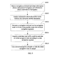
- FIG 4 shows a detailed flowchart of planning a navigation route according to the present invention.
- a navigation screen is presented on a man-machine interface 102, and a user inputs a navigation command on the navigation screen.
- a navigation terminal 100 receives the navigation command input by the user through the man-machine interface 102.
- the navigation command includes information about a start point of navigation and information about a destination of navigation.
- a satellite positioning unit (such as a GPS unit) 105 determines a current position of a vehicle.
- the current position of the vehicle may be position information indicated by numbers.
- step S401 and step S402 in this implementation manner are described successively, in a specific application, because processing units for these two steps are the man-machine interface 102 and the satellite positioning unit 105 respectively, which operate independently, a sequence of these two steps may be adjusted, or there may be no sequence between them.
- a communications interface 103 sends the navigation command and current position information of the vehicle to a remote navigation service system 200 through a communications connection 400.
- a real-time road condition acquiring unit 203 of the remote navigation service system 200 keeps on acquiring road condition information in real time, and this process is performed synchronously with other implementation steps.
- a step in which the real-time road condition acquiring unit 203 acquires the real-time road condition is listed as step S501.
- the real-time road condition acquiring unit 203 still acquires the real-time road information, which is not only performed before step S502, which must be explained first.
- a communications interface 201 in the remote navigation service system 200 receives the navigation command and the current position information of the vehicle.
- a route planning unit 204 plans a navigation route of the vehicle based on the navigation command and the position information of the vehicle.
- the route planning unit 204 may also re-plan the navigation route according to the real-time dynamic road condition information, so that the vehicle may avoid a congested segment of a road. Details of step S503 and step S504 is described in FIG. 5 .
- step S505 the route planning unit 204 generates a navigation indication according to a planned driving route.
- step S506 the navigation indication is sent to the navigation terminal 100 through the communications interface 201.
- step S404 the navigation terminal 100 receives the navigation indication through the communications interface 103.
- a display unit 104 presents the navigation indication to the user, that is, a driver of the vehicle.
- the navigation indication includes a voice prompt, where the voice prompt is played by a speaker of the man-machine interface 102 and presented to the user.
- a navigation indication sent back by the remote navigation service system 200 includes a driving direction indication
- the navigation terminal 100 includes a camera apparatus 108 at the same time, where the camera apparatus 108 photographs a road scene in front of the vehicle, the driving direction indication is superimposed on the road scene and displayed on a display screen of the man-machine interface 102 to present a next step travelling direction when the vehicle reaches each navigation node.
- FIG. 5 shows a detailed flowchart illustrating that the route planning unit 204 plans a driving route according to a real-time road condition in an implementation manner of the present invention.
- step S5031 the route planning unit 204 parses the navigation command and obtains information about a start point of navigation and information about a destination of navigation, for example, information about a start point A and a destination S shown in FIG. 3 .
- step S5032 the route planning unit 204 analyses information about all possible routes between the start point A and the destination S according to map data provided by the memory 205.
- step S5033 the route planning unit 204 sets places where all determined possible routes intersect as navigation nodes. As a result, all the possible routes are divided into multiple navigation segments by these navigation nodes.
- the route planning unit 204 determines a navigation segment in which traffic congestion occurs among multiple navigation segments according to real-time road condition information provided by the real-time road condition acquiring unit 203, so as to select clear navigation segments between the start point and the destination of navigation, and uses the navigation nodes to connect these clear navigation segments to form an initially planned navigation route that is determined based on a principle of the most clear route first.
- the route planning unit 204 may further use a second navigation principle, such as a principle of the shortest route first, so as to make the initially planned route be unique. The unique planned route is then converted into a navigation indication and transferred to a navigation terminal 100.
- the satellite positioning unit 105 determines, in real time, position information of the vehicle, and the position information may be transferred, in real time, to the remote navigation service system 200 through the communications interface 103.
- the route planning unit 204 plans a navigation route from the first navigation node, for example, the navigation node D shown in FIG. 3 , to the navigation destination S according to real-time dynamic road condition information.
Landscapes
- Engineering & Computer Science (AREA)
- Radar, Positioning & Navigation (AREA)
- Remote Sensing (AREA)
- Automation & Control Theory (AREA)
- Physics & Mathematics (AREA)
- General Physics & Mathematics (AREA)
- Multimedia (AREA)
- Mechanical Engineering (AREA)
- Health & Medical Sciences (AREA)
- Audiology, Speech & Language Pathology (AREA)
- General Health & Medical Sciences (AREA)
- Computer Networks & Wireless Communication (AREA)
- Navigation (AREA)
- Computer Vision & Pattern Recognition (AREA)
Abstract
Description
- This application claims priority to Chinese Patent Application No.
201210351868.7 - The present invention relates to a navigation technology, and in particular, to a terminal, a system, and a method that can implement real-time navigation according to a road condition.
- Continuous expansion of modern cities leads to continuous extension of roads. Accompanied by rapid development of the automobile industry, automobiles are increasingly popularized, a travelling radius of people is getting larger. Due to an increase of a travelling radius and an increase of road complexity, people have to use a navigation apparatus during travelling, so as to quickly reach a destination. Currently, most road navigation apparatuses used for a vehicle have a road positioning function and a road navigation function. When a global satellite positioning system is used with an azimuth detector, and a vehicle speed detector, the road positioning function is used to calculate a position coordinate of the vehicle in real time, and compare the position coordinate with stored road data in a road database to work out a road on which the vehicle is currently travelling as well as a specific position of the vehicle on the road. A map of which data becomes larger requires to be updated continually by a user, which also imposes a higher requirement on software and hardware capabilities of a navigation terminal. Implementation of a required navigation service for a user of the terminal requires higher configuration costs.
- In addition, an increasing number of vehicles on the road also leads to a worse traffic condition. A conventional navigation manner of simply planning a route cannot meet a practical requirement of the user of the terminal. A better solution is required to improve user experience.
- In view of this, an objective of the present invention is to provide a real-time navigation service system and a navigation terminal, so as to provide a quick and real-time navigation service.
- In an implementation manner of the present invention, a navigation terminal is connected to and communicates with a remote navigation service system, where the navigation terminal includes: a man-machine interface, configured to receive a navigation command input by a user; a communications interface, configured to implement remote communication; a satellite positioning unit, configured to determine current position information of a vehicle; and a navigation unit. The satellite positioning unit may be a GPS (Global Position System, Global Positioning System) unit or another unit that has a satellite positioning function. The navigation unit is configured to send the navigation command and the current position information of the vehicle to the remote navigation service system through the communications interface, and receive a navigation indication sent back by the remote navigation service system through the communications interface. The man-machine interface includes a touch display screen, which is configured to input the navigation command for the user, and the man-machine interface is further configured to present the navigation indication.
- As a further improvement of the present invention, the navigation terminal further includes a camera apparatus, which is configured to photograph a road scene in front of the vehicle, where the road scene is displayed on the display screen of the man-machine interface.
- As a further improvement of the present invention, the navigation indication includes a driving direction indication, where the driving direction indication is superimposed on the road scene to present a travelling direction of the vehicle.
- As a further improvement of the present invention, the navigation indication includes a voice prompt, the man-machine interface includes a speaker, and the voice prompt is played by the speaker and presented to the user.
- As a further improvement of the present invention, the navigation command includes information about a start point of navigation and information about a destination of navigation.
- As a further improvement of the present invention, the camera apparatus is built in a body of the navigation terminal.
- As a further improvement of the present invention, the camera apparatus is separated from a body of the navigation terminal and is disposed at a front end of the vehicle, and transfers the photographed road scene to the body of the navigation terminal in a wired or wireless manner, and the photographed road scene is displayed on the display screen of the man-machine interface.
- A navigation method of a navigation terminal in an implementation manner of the present invention includes: receiving a navigation command input by a user; starting a satellite positioning unit to determine current position information of a vehicle; sending the navigation command and the current position information of the vehicle to a remote navigation service system through a communications interface; receiving a navigation indication sent back by the remote navigation service system through the communications interface; and presenting the navigation indication to the user for navigation.
- As a further improvement of the present invention, the navigation method further includes photographing a road scene in front of the vehicle, where the road scene is displayed on a display screen of a man-machine interface.
- As a further improvement of the present invention, the navigation indication includes a driving direction indication, where the driving direction indication is superimposed on the road scene to present a travelling direction of the vehicle.
- As a further improvement of the present invention, the navigation indication includes a voice prompt, the man-machine interface includes a speaker, and the voice prompt is played by the speaker and presented to the user.
- A remote navigation service system in an implementation manner of the present invention is configured to provide a navigation service for a navigation terminal, where the remote navigation service system includes: a communications interface, configured to receive a navigation command and current position information of a vehicle from the navigation terminal; a real-time road condition acquiring unit, configured to acquire a real-time road traffic condition; and a route planning unit, configured to plan, based on a default navigation principle, a driving route according to the navigation command and the real-time road traffic condition, and form a navigation indication with reference to the current position information of the vehicle. The navigation indication is sent to the navigation terminal through the communications interface.
- As a further improvement of the present invention, the navigation indication includes a driving direction indication, which is used to indicate a travelling direction of the vehicle in a current position.
- As a further improvement of the present invention, the navigation indication includes a voice prompt, which is used to perform voice broadcasting of a travelling direction of the vehicle in a current position.
- As a further improvement of the present invention, the navigation command includes information about a start point of navigation and information about a destination of navigation.
- As a further improvement of the present invention, the route planning unit divides a road between the start point and the destination into multiple navigation segments, where each two adjacent navigation segments are connected by a navigation node. As a further improvement of the present invention, the navigation node is a road intersection.
- As a further improvement of the present invention, the route planning unit connects, by using the navigation node, clear navigation segments between the start point and the destination of navigation to form a proposed navigation route.
- As a further improvement of the present invention, the route planning unit may further select the proposed navigation route according to a second navigation principle.
- As a further improvement of the present invention, the route planning unit calculates, based on the second navigation principle and according to a length of each navigation segment and a currently feasible travelling speed under a real-time road condition, time required to pass through a corresponding navigation segment.
- As a further improvement of the present invention, the route planning unit selects, according to the time required to pass through each navigation segment, a navigation route with a shortest travelling time from the current position of the vehicle to the destination of navigation.
- As a further improvement of the present invention, the route planning unit determines, according to a next navigation segment to which each navigation node is directed in a planned navigation route, a navigation indication that s used when the vehicle travels to the navigation node.
- As a further improvement of the present invention, the navigation indication is sent to the navigation terminal through the communications interface before the vehicle reaches each navigation node.
- As a further improvement of the present invention, the real-time road condition acquiring unit acquires the real-time road traffic condition from a server of a city monitoring system or a data center of a traffic police department in a wired or wireless manner.
- In implementation manners of the present invention, a user is provided with a more real-time and quicker navigation service by configuring services, such as map storage and navigation calculation, in a remote navigation service system, using a powerful storage and computing capability of the remote navigation service system, and acquiring real-time road traffic condition information in an all-around and professional way. As a result, user experience is improved.
-
-
FIG. 1 shows a schematic diagram of an architecture of a navigation terminal and a remote navigation service system in a specific implementation manner of the present invention; -
FIG 2 shows another schematic diagram of an architecture of a navigation terminal and a remote navigation service system in a specific implementation manner of the present invention; -
FIG 3 shows still another schematic diagram of an architecture of a navigation terminal and a remote navigation service system in a specific implementation manner of the present invention; -
FIG 4 shows a flowchart of planning a navigation route according to the present invention; -
FIG 5 is a detailed flowchart of steps, shown inFIG 4 , for re-planning a route according to a real-time dynamic road condition; -
FIG. 6 shows a schematic diagram of a navigation route planning principle according to the present invention; and -
FIG. 7 is a simplified diagram of a navigation route planning principle according toFIG. 6 . -
FIG 1 shows a schematic diagram of an architecture of anavigation terminal 100 and a remotenavigation service system 200 in a specific implementation manner of the present invention. Thenavigation terminal 100 is installed or placed on a vehicle (not shown in the figure), and is configured to communicate with the remotenavigation service system 200 and obtain a navigation indication from the remotenavigation service system 200 to perform vehicle navigation. - In this implementation manner of the present invention, the
navigation terminal 100 uses a star structure and includes aprocessor 101, a man-machine interface 102, acommunications interface 103, asatellite positioning unit 105, and amemory 107. In another implementation manner of the present invention, thenavigation terminal 100 may also use a bus structure. In a specific implementation manner, the satellite positioning unit may be a GPS unit or another unit that has a satellite positioning function, may be a separate module or unit, or a module or unit integrated into theprocessor 101, which is not limited in the present invention. - The man-
machine 102 is configured to receive a navigation command input by a user. In this implementation manner of the present invention, the man-machine interface 102 includes a display screen, and in particular, a touch display screen. The user inputs the navigation command in a touch manner. In this specific implementation manner, the navigation command includes information about a start point of navigation and information about a destination of navigation. Thecommunications interface 103 may be specifically a transceiver, which is configured to implement remote communication. For example, thecommunications interface 103 is connected to and communicates with the remotenavigation service system 200. Thesatellite positioning unit 105 communicates with apositioning satellite 300 to determine a current position of the vehicle. In this implementation manner, the current position of the vehicle may be position information indicated by numbers. - In another implementation manner of the present invention, as shown in
FIG 2 , theprocessor 101 includes anavigation unit 106 and adisplay unit 104. Thenavigation unit 106 and thedisplay unit 104 may be a computer executable program, which is executed by theprocessor 101. Thenavigation unit 106 is configured to send the navigation command and the current position information of the vehicle to the remotenavigation service system 200 through thecommunications interface 103 by using acommunications connection 400, and receive a navigation indication sent back by the remotenavigation service system 200 through the communications interface. Thedisplay unit 104 is configured to present the navigation indication to the user. Specifically, the navigation indication may be presented by controlling the man-machine interface 102. In this implementation manner of the present invention, thecommunications connection 400 includes, but is not limited to, a communications connection implemented by using technologies, such as GSM (Global System For Mobile Communications, Global System For Mobile Communications), WiFi (Wireless Fidelity, Wireless Fidelity), WiMAX (Worldwide Interoperability for Microwave Access, Worldwide Interoperability for Microwave Access), CDMA (Code Division Multiple Access, Code Division Multiple Access), HSPA (High Speed Packet Access, High Speed Packet Access), or LTE (Long Term Evolution, Long Term Evolution). - The remote
navigation service system 200 is configured to provide a navigation service for thenavigation terminal 100, including planning a route and generating the navigation indication according to the navigation command, and the like. Thenavigation service system 200 includes acommunications interface 201. Thecommunications interface 201 may be specifically a transceiver, which is configured to receive the navigation command and current position information of the vehicle from thenavigation terminal 100, where the navigation command may include information about a start point of navigation and information about a destination of navigation; thenavigation service system 200 includes aprocessor 202, which is configured to plan, based on a default navigation principle, a driving route according to the navigation command and an acquired real-time road traffic condition, and form the navigation indication with reference to the current position information of the vehicle, where the navigation indication is sent to the navigation terminal through thecommunications interface 201; and amemory 205. In this implementation manner of the present invention, thenavigation service system 200 may be designed based on a Cloud (Cloud) server architecture. In still another implementation manner of the present invention, as shown inFIG 3 , theprocessor 202 includes a real-time roadcondition acquiring unit 203 and aroute planning unit 204. In this implementation manner of the present invention, theprocessor 202 may be a processor that has a supercomputing capability and can execute multiple tasks at the same time. The real-time roadcondition acquiring unit 203 and theroute planning unit 204 are software modules that can be compiled and executed by a computer, and are executed by theprocessor 202 in the present invention, to implement a function of navigation route planning. In another implementation manner of the present invention, a function of theprocessor 202 may be implemented by renting technical support of a supercomputing center. The supercomputing center refers to a computing center with a computing speed higher than 1000 trillion operations per second, and includes but is not limited to four existing national supercomputing centers in China: National Supercomputing Center in Tianjin, National Supercomputing Center in Shenzhen, National Supercomputing Center in Changsha, and National Supercomputing Center in Jinan. - The real-time road
condition acquiring unit 203 is configured to acquire data of a real-time road traffic condition. In practice, the data of a real-time road traffic condition may be obtained in real time by camera apparatuses distributed throughout a city, and the data is stored in a data center of a traffic police department or a server of a city monitoring system. The real-time roadcondition acquiring unit 203 is connected to and communicates with the data center of the traffic police department or the server of the city monitoring system, and acquires the data of a real-time road traffic condition in a wired or wireless manner. The wireless manner includes communication implemented by using a WiMax (Worldwide Interoperability for Microwave Access, Worldwide Interoperability for Microwave Access) technology. Theroute planning unit 204 is configured to plan, based on a default navigation principle, a driving route according to the navigation command and the acquired real-time road traffic condition, and form the navigation indication with reference to the current position information of the vehicle. - Massive map data may be stored in the
memory 205. Theroute planning unit 204 may be specifically configured to plan a driving route according to the navigation command and the real-time road traffic condition, and form the navigation indication with reference to the current position of the vehicle and the map data in thememory 205. The navigation command includes information about a start point of navigation and information about a destination of navigation. In this implementation manner of the present invention, the navigation indication includes a driving direction indication, which is used to indicate a travelling direction of the vehicle in the current position. In another implementation manner of the present invention, the navigation indication may further include a voice prompt, which is used to perform voice broadcasting of a travelling direction of the vehicle in the current position. - The navigation indication is sent to the
navigation terminal 100 through thecommunications interface 201. - In a specific implementation manner of the present invention, the
route planning unit 204 divides a road between the start point and the destination of navigation into multiple navigation segments when planning the route, where each two adjacent navigation segments are connected by a navigation node. The following schematically describes the navigation method of the present invention with reference to a real map shown inFIG 2 . - For example, a vehicle sets off from Gangtou (start point) in Shenzhen to a place (destination) in the High-tech Industrial Park in Nanshan District, as shown in
FIG 6 , and there are a variety of feasible route options. Each road intersection shown in the map is defined as a navigation node, such as locations in circles such as A (start point), B, C, D, E, F, G, H, I, J, K, L, M (destination) shown inFIG 6 , while a route between each two adjacent nodes is defined as a navigation segment, for example, a route between the navigation node B and the navigation node C is referred to as a navigation segment BC, and a route between the navigation node D and the navigation node E is referred to as a navigation segment DE, and so on.FIG. 7 shows a schematic diagram of a principle of navigation route planning performed by the remotenavigation service system 200 of the present invention, which is summarized according to what is shown inFIG 6 . In the schematic diagram shown inFIG 7 , the navigation node A is defined as a start point of navigation, and a navigation node S is defined as a destination of navigation. The start point A of navigation is connected to the destination S of navigation by multiple routes, and these routes are divided into multiple segments AB, AC......RS, and the like by navigation nodes B to R. In a specific implementation manner of the present invention, theroute planning unit 204 may initially plan a route from A to S according to a default navigation principle. The default navigation principle includes shortest route first, highway first, minimum toll first, shortest time first, most clear route first, and the like. In this implementation manner of the present invention, the default navigation principle is the most clear route first. When planning a default route, theroute planning unit 204 firstly selects clear navigation segments between a start point of navigation and a destination of navigation, and then uses navigation nodes to connect these clear navigation segments to form a default, also referred to as initially planned, navigation route. When a road is in a good condition, there may be multiple navigation routes determined based on the principle of the most clear route first. Therefore, in another implementation manner of the present invention, a second navigation principle is defined as a complement to the default navigation principle, so as to make a finally planned route be a unique route. For example, when all routes are clear, there are multiple clear routes from the start point A of navigation to the destination S of navigation, which may be "A-D-I-O-R-S", or may be "A-E-J-O-R-S", or the like. In this case, theroute planning unit 204 may further use the second navigation principle, for example, a principle of the shortest route first, to perform secondary path planning, so that a finally planned route is uniquely determined, such as "A-E-J-P-S". - When a vehicle that carries the
navigation terminal 100 sets off from the start point A of navigation and travels along a navigation segment AD, theroute planning unit 204 confirms whether a next navigation segment DI planned in advance is clear according to a real-time road condition obtained by the real-time roadcondition acquiring unit 203. If the next navigation segment DI is clear, when the vehicle reaches the navigation node D, theroute planning unit 204 sends a navigation indication to the navigation terminal to indicate, to a vehicle driver, that the vehicle driver can continue to drive along the navigation segment DI . When the vehicle travels along the navigation segment AD, if theroute planning unit 204 determines, according to a real-time road condition, that congestion occurs on the navigation segment DI for some reason, theroute planning unit 204 re-plans a clear route from the navigation node D to the navigation destination S according to the map data in thememory 205 and the real-time road condition obtained by the real-time roadcondition acquiring unit 203. Referring to the foregoing description, when there are multiple clear routes between the navigation node D and the navigation destination S, theroute planning unit 204 starts the second navigation principle to determine a unique navigation route. For example, when both a route "D-C-H-I" and a route "D-E-I" are clear, theroute planning unit 204 finally selects the route "D-E-I" that is shorter as a proposed navigation route, and when the vehicle is about to reach the navigation node D, theroute planning unit 204 sends a navigation indication to thenavigation terminal 100, to indicate, to the vehicle driver, that the vehicle driver can drive along the navigation segment DE after reaching the navigation node D. That is, when the vehicle travels to the navigation node, theroute planning unit 204 determines a navigation indication according to a next navigation segment to which each navigation node is directed in a planned navigation route. - In another implementation manner of the present invention, the second navigation principle may further be a principle of shortest time first. For example, the
route planning unit 204 calculates, according to a length of each navigation segment and a currently feasible travelling speed under the real-time road condition, time required to pass through a corresponding navigation segment, and plans a navigation route with a shortest travelling time from the current position of the vehicle to the destination S of navigation according to a length of time required to pass through each segment. - In a process in which the vehicle travels along a navigation segment DE, the
route planning unit 204 also makes a judgment according to a real-time road condition, and sends a navigation indication to thenavigation terminal 100 when the vehicle reaches a navigation node E, to indicate a direction in which the vehicle driver travels after reaching the navigation node E. - In this implementation manner of the present invention, the navigation indication is sent to the
navigation terminal 100 through thecommunications interface 201 before the vehicle reaches each navigation node. The man-machine interface 102 is further configured to present the navigation indication. In a specific implementation manner of the present invention, the navigation indication includes a voice prompt, the man-machine interface 102 includes a speaker, and the voice prompt is played by the speaker and presented to the user. - In another implementation manner of the present invention, the
navigation terminal 100 further includes acamera apparatus 108, which is configured to photograph a road scene in front of the vehicle, where the road scene is displayed in real time on a display screen of the man-machine interface 102. In this implementation manner, thecamera apparatus 108 is a camera. In a specific implementation manner of the present invention, thecamera apparatus 108 is built in thenavigation terminal 100. In another specific implementation manner of the present invention, the camera apparatus is separated from a body of thenavigation terminal 100 and is installed at a front end of the vehicle, and transfers the photographed road scene to the body of thenavigation terminal 100 in a wired or wireless manner, and the photographed road scene is displayed on the display screen of the man-machine interface 102. In a specific implementation manner of the present invention, the navigation indication sent back by the remotenavigation service system 200 includes a driving direction indication, and the driving direction indication is superimposed on the road scene, and is displayed on the display screen of the man-machine interface 102, so as to more vividly and visually present a travelling direction when the vehicle reaches each navigation node. Because the road scene is photographed in real time and visually reflects a real scenario, the driving direction indication is superimposed on the real scenario and then displayed, so as to provide a more vivid and visual travelling prompt to the user. Therefore, user experience is improved, and a function of the navigation terminal is enhanced. This part may also be implemented by using an AR (Augmented Reality, Augmented Reality) technology, which is not limited in the present invention. The camera apparatus may also exist in another form, such as an apparatus that is put on the head or eyes of the user, for example, a pair of glasses with a camera, which is not limited in the present invention. -
FIG 4 shows a detailed flowchart of planning a navigation route according to the present invention. When a navigation service is required, a navigation screen is presented on a man-machine interface 102, and a user inputs a navigation command on the navigation screen. In step S401, anavigation terminal 100 receives the navigation command input by the user through the man-machine interface 102. The navigation command includes information about a start point of navigation and information about a destination of navigation. In step S402, a satellite positioning unit (such as a GPS unit) 105 determines a current position of a vehicle. In this implementation manner, the current position of the vehicle may be position information indicated by numbers. It should be noted that, although step S401 and step S402 in this implementation manner are described successively, in a specific application, because processing units for these two steps are the man-machine interface 102 and thesatellite positioning unit 105 respectively, which operate independently, a sequence of these two steps may be adjusted, or there may be no sequence between them. In step S403, acommunications interface 103 sends the navigation command and current position information of the vehicle to a remotenavigation service system 200 through acommunications connection 400. - In this implementation manner of the present invention, a real-time road
condition acquiring unit 203 of the remotenavigation service system 200 keeps on acquiring road condition information in real time, and this process is performed synchronously with other implementation steps. For ease of description, in this implementation manner, a step in which the real-time roadcondition acquiring unit 203 acquires the real-time road condition is listed as step S501. In practice, in a process of implementing other steps, the real-time roadcondition acquiring unit 203 still acquires the real-time road information, which is not only performed before step S502, which must be explained first. - In step S502, a
communications interface 201 in the remotenavigation service system 200 receives the navigation command and the current position information of the vehicle. In step S503, aroute planning unit 204 plans a navigation route of the vehicle based on the navigation command and the position information of the vehicle. In step S504, theroute planning unit 204 may also re-plan the navigation route according to the real-time dynamic road condition information, so that the vehicle may avoid a congested segment of a road. Details of step S503 and step S504 is described inFIG. 5 . - In step S505, the
route planning unit 204 generates a navigation indication according to a planned driving route. In step S506, the navigation indication is sent to thenavigation terminal 100 through thecommunications interface 201. - In step S404, the
navigation terminal 100 receives the navigation indication through thecommunications interface 103. In step S405, adisplay unit 104 presents the navigation indication to the user, that is, a driver of the vehicle. In this implementation manner of the present invention, the navigation indication includes a voice prompt, where the voice prompt is played by a speaker of the man-machine interface 102 and presented to the user. In another implementation manner of the present invention, a navigation indication sent back by the remotenavigation service system 200 includes a driving direction indication, and thenavigation terminal 100 includes acamera apparatus 108 at the same time, where thecamera apparatus 108 photographs a road scene in front of the vehicle, the driving direction indication is superimposed on the road scene and displayed on a display screen of the man-machine interface 102 to present a next step travelling direction when the vehicle reaches each navigation node.FIG. 5 shows a detailed flowchart illustrating that theroute planning unit 204 plans a driving route according to a real-time road condition in an implementation manner of the present invention. In step S5031, theroute planning unit 204 parses the navigation command and obtains information about a start point of navigation and information about a destination of navigation, for example, information about a start point A and a destination S shown inFIG. 3 . In step S5032, theroute planning unit 204 analyses information about all possible routes between the start point A and the destination S according to map data provided by thememory 205. In step S5033, theroute planning unit 204 sets places where all determined possible routes intersect as navigation nodes. As a result, all the possible routes are divided into multiple navigation segments by these navigation nodes. - In step S5304, the
route planning unit 204 determines a navigation segment in which traffic congestion occurs among multiple navigation segments according to real-time road condition information provided by the real-time roadcondition acquiring unit 203, so as to select clear navigation segments between the start point and the destination of navigation, and uses the navigation nodes to connect these clear navigation segments to form an initially planned navigation route that is determined based on a principle of the most clear route first. When a road is in a good condition, there are multiple initially planned navigation routes that are determined based on the principle of the most clear route first. Therefore, in step S5035, theroute planning unit 204 may further use a second navigation principle, such as a principle of the shortest route first, so as to make the initially planned route be unique. The unique planned route is then converted into a navigation indication and transferred to anavigation terminal 100. - In this implementation manner of the present invention, when the vehicle travels on a first navigation node in a planned route in the navigation indication, the
satellite positioning unit 105 determines, in real time, position information of the vehicle, and the position information may be transferred, in real time, to the remotenavigation service system 200 through thecommunications interface 103. During this period, theroute planning unit 204 plans a navigation route from the first navigation node, for example, the navigation node D shown inFIG. 3 , to the navigation destination S according to real-time dynamic road condition information. - The foregoing descriptions are merely exemplary implementation manners of the present invention, but are not intended to limit the protection scope of the present invention. Any equivalent changes and modifications made within the conception and principle of the present invention shall fall within the protection scope of the present invention.
Claims (25)
- A navigation terminal, which is connected to and communicates with a remote navigation service system, to perform vehicle navigation, wherein the navigation terminal comprises:a man-machine interface, configured to receive a navigation command input by a user, wherein the man-machine interface comprises a display screen;a communications interface, configured to implement remote communication;a satellite positioning unit, configured to determine current position information of a vehicle; anda processor, configured to send the navigation command and the current position information of the vehicle to the remote navigation service system through the communications interface, and receive a navigation indication sent back by the remote navigation service system through the communications interface, whereinthe man-machine interface is further configured to present the navigation indication.
- The navigation terminal according to claim 1, further comprising a camera apparatus, configured to photograph a road scene in front of the vehicle, wherein the road scene is displayed on the display screen of the man-machine interface.
- The navigation terminal according to claim 2, wherein the navigation indication comprises a driving direction indication, and the driving direction indication is superimposed on the road scene for navigation.
- The navigation terminal according to claim 1, wherein the navigation indication comprises a voice prompt, the man-machine interface comprises a speaker, and the voice prompt is played by the speaker and presented to the user.
- The navigation terminal according to any one of claims 1 to 4, wherein the navigation command comprises information about a start point of navigation and information about a destination of navigation.
- The navigation terminal according to claim 2 or 3, wherein the camera apparatus is built in a body of the navigation terminal.
- The navigation terminal according to claim 2 or 3, wherein the camera apparatus is separated from a body of the navigation terminal and is disposed at a front end of the vehicle, and transfers the photographed road scene to the body of the navigation terminal in a wired or wireless manner, and the photographed road scene is displayed on the display screen of the man-machine interface.
- A navigation method, comprising:receiving a navigation command input by a user;starting a satellite positioning unit to determine current position information of a vehicle;sending the navigation command and the current position information of the vehicle to a remote navigation service system through a communications interface;receiving a navigation indication sent back by the remote navigation service system through the communications interface; andpresenting the navigation indication to the user for navigation.
- The navigation method according to claim 8, comprising:photographing a road scene in front of the vehicle, wherein the road scene is displayed on a display screen of a man-machine interface.
- The navigation method according to claim 9, wherein the navigation indication comprises a driving direction indication, and the driving direction indication is superimposed on the road scene for navigation.
- The navigation method according to claim 8, wherein the navigation indication comprises a voice prompt, the man-machine interface comprises a speaker, and the voice prompt is played by the speaker and presented to the user.
- The navigation method according to any one of claims 8 to 11, wherein the navigation command comprises information about a start point of navigation and information about a destination of navigation.
- A remote navigation service system, configured to provide a navigation service for a navigation terminal, wherein the navigation service system comprises:a communications interface, configured to receive a navigation command and current position information of a vehicle from the navigation terminal, wherein the navigation command comprises information about a start point of navigation and information about a destination of navigation; anda processor, configured to plan, based on a default navigation principle, a driving route according to the navigation command and an acquired real-time road traffic condition, and form a navigation indication with reference to the current position information of the vehicle, whereinthe navigation indication is sent to the navigation terminal through the communications interface.
- The remote navigation service system according to claim 13, wherein the navigation indication comprises a driving direction indication, which is used to indicate a travelling direction of the vehicle in a current position.
- The remote navigation service system according to claim 13, wherein the navigation indication comprises a voice prompt, which is used to perform voice broadcasting of a travelling direction of the vehicle in a current position.
- The remote navigation service system according to any one of claims 13 to 15, wherein the processor specifically comprises:a real-time route acquiring unit, configured to acquire a real-time road traffic condition; anda route planning unit, configured to plan, based on the default navigation principle, the driving route according to the navigation command and the acquired real-time road traffic condition, and form the navigation indication with reference to the current position information of the vehicle, whereinthe navigation indication is sent to the navigation terminal through the communications interface.
- The remote navigation service system according to claim 16, wherein the route planning unit divides a road between the start point and the destination into multiple navigation segments, wherein each two adjacent navigation segments are connected by a navigation node.
- The remote navigation service system according to claim 17, wherein the navigation node is a road intersection.
- The remote navigation service system according to claim 17, wherein the route planning unit connects, by using the navigation node, clear navigation segments between the start point and the destination of navigation to form a proposed navigation route.
- The remote navigation service system according to claim 19, wherein the route planning unit may further select the proposed navigation route according to a second navigation principle.
- The remote navigation service system according to claim 20, wherein the route planning unit calculates, based on the second navigation principle and according to a length of each navigation segment and a currently feasible travelling speed under a real-time road condition, time required to pass through a corresponding navigation segment.
- The remote navigation service system according to claim 21, wherein the route planning unit selects, according to the time required to pass through each navigation segment, a navigation route with a shortest travelling time from the current position of the vehicle to the destination of navigation.
- The remote navigation service system according to any one of claims 19 to 22, wherein the route planning unit determines, according to a next navigation segment to which each navigation node is directed in a planned navigation route, a navigation indication that is used when the vehicle travels to the navigation node.
- The remote navigation service system according to claim 23, wherein the navigation indication is sent to the navigation terminal through the communications interface before the vehicle reaches each navigation node.
- The remote navigation service system according to any one of claims 13 to 22, wherein the real-time road condition acquiring unit acquires the real-time road traffic condition from a server of a city monitoring system or a data center of a traffic police department in a wired or wireless manner.
Applications Claiming Priority (2)
| Application Number | Priority Date | Filing Date | Title |
|---|---|---|---|
| CN2012103518687A CN102879000A (en) | 2012-09-20 | 2012-09-20 | Navigation terminal, navigation method and remote navigation service system |
| PCT/CN2013/083673 WO2014044173A1 (en) | 2012-09-20 | 2013-09-17 | Navigation terminal, navigation method and remote navigation service system |
Publications (2)
| Publication Number | Publication Date |
|---|---|
| EP2889581A1 true EP2889581A1 (en) | 2015-07-01 |
| EP2889581A4 EP2889581A4 (en) | 2015-09-02 |
Family
ID=47480419
Family Applications (1)
| Application Number | Title | Priority Date | Filing Date |
|---|---|---|---|
| EP13839553.8A Withdrawn EP2889581A4 (en) | 2012-09-20 | 2013-09-17 | Navigation terminal, navigation method and remote navigation service system |
Country Status (4)
| Country | Link |
|---|---|
| US (1) | US20150346348A1 (en) |
| EP (1) | EP2889581A4 (en) |
| CN (1) | CN102879000A (en) |
| WO (1) | WO2014044173A1 (en) |
Cited By (2)
| Publication number | Priority date | Publication date | Assignee | Title |
|---|---|---|---|---|
| EP2960630A3 (en) * | 2014-06-26 | 2016-03-23 | LG Electronics Inc. | Eyewear-type terminal and method for controlling the same |
| CN106441343A (en) * | 2016-08-31 | 2017-02-22 | 电子科技大学 | Street view navigation method based on character recognition |
Families Citing this family (28)
| Publication number | Priority date | Publication date | Assignee | Title |
|---|---|---|---|---|
| CN102879000A (en) * | 2012-09-20 | 2013-01-16 | 华为终端有限公司 | Navigation terminal, navigation method and remote navigation service system |
| CN103258439B (en) * | 2013-04-26 | 2015-05-13 | 常雪阳 | Intelligent traffic guidance system and method based on three-in-one network |
| CN104121910A (en) * | 2013-04-28 | 2014-10-29 | 腾讯科技(深圳)有限公司 | Navigation method and device, terminal, server and system |
| US9699373B2 (en) | 2013-04-28 | 2017-07-04 | Tencnt Technology (Shenzhen) Company Limited | Providing navigation information to a point of interest on real-time street views using a mobile device |
| CN103487059B (en) * | 2013-09-25 | 2016-12-07 | 中国科学院深圳先进技术研究院 | A kind of Position Fixing Navigation System, device and method |
| CN103674037B (en) * | 2013-12-16 | 2017-09-29 | 联想(北京)有限公司 | A kind of information processing method and device |
| CN104316071B (en) * | 2014-09-23 | 2017-08-01 | 福州海峡职业技术学院 | The powering method of guider |
| CN104316070B (en) * | 2014-09-23 | 2017-11-17 | 福州海峡职业技术学院 | A kind of guider |
| US11372479B2 (en) | 2014-11-10 | 2022-06-28 | Irisvision, Inc. | Multi-modal vision enhancement system |
| US11546527B2 (en) | 2018-07-05 | 2023-01-03 | Irisvision, Inc. | Methods and apparatuses for compensating for retinitis pigmentosa |
| US12504810B2 (en) | 2014-11-10 | 2025-12-23 | Irisvision, Inc. | Method and system for remote clinician management of head-mounted vision assist devices |
| CN104359487B (en) * | 2014-11-13 | 2017-06-23 | 沈阳美行科技有限公司 | A kind of real scene navigation system |
| US10832573B2 (en) | 2015-01-12 | 2020-11-10 | International Business Machines Corporation | Modifying travel estimates based on schedule anxiety |
| US20160264051A1 (en) * | 2015-03-12 | 2016-09-15 | Visionize Corp. | Night Driving System and Method |
| CN104880193A (en) * | 2015-05-06 | 2015-09-02 | 石立公 | Lane-level navigation system and lane-level navigation method thereof |
| CN106441339A (en) * | 2015-08-06 | 2017-02-22 | 平安科技(深圳)有限公司 | Automobile, and automobile navigation control method and system |
| CN106991727B (en) * | 2016-01-21 | 2020-07-10 | 北京四维图新科技股份有限公司 | Highway intercommunication charging method and system |
| US11015944B2 (en) * | 2017-08-01 | 2021-05-25 | Ford Global Technologies, Llc | Method and apparatus for dynamic navigation modification |
| CN107907135A (en) * | 2017-10-23 | 2018-04-13 | 林楚莲 | A kind of navigation alarm method and system |
| EP3752977A4 (en) | 2018-02-13 | 2022-04-06 | Frank Werblin | Methods and apparatus for contrast sensitivity compensation |
| CN112344954A (en) * | 2019-08-06 | 2021-02-09 | 上海博泰悦臻电子设备制造有限公司 | Virtual navigation method and system |
| CN110737736B (en) * | 2019-09-16 | 2024-02-09 | 连尚(新昌)网络科技有限公司 | Method and equipment for acquiring vehicle condition map information |
| CN111664865A (en) * | 2020-06-03 | 2020-09-15 | 武汉中海庭数据技术有限公司 | Live-action navigation system and method based on high-precision data |
| CN114061613A (en) * | 2020-08-07 | 2022-02-18 | 奥迪股份公司 | Method, device, medium and vehicle for providing vehicle navigation service |
| CN112697160A (en) * | 2020-12-03 | 2021-04-23 | 文诚恒远(天津)供应链管理服务有限公司 | Navigation path recommendation method and device and electronic equipment |
| CN113085900B (en) * | 2021-04-29 | 2022-11-04 | 的卢技术有限公司 | Method for calling vehicle to travel to user position |
| CN115394110A (en) * | 2022-08-25 | 2022-11-25 | 长城汽车股份有限公司 | Vehicle position display method and vehicle |
| CN119223318A (en) * | 2023-06-30 | 2024-12-31 | 华为技术有限公司 | Navigation method, device, storage medium, program product and vehicle |
Family Cites Families (25)
| Publication number | Priority date | Publication date | Assignee | Title |
|---|---|---|---|---|
| US6292743B1 (en) * | 1999-01-06 | 2001-09-18 | Infogation Corporation | Mobile navigation system |
| US6253146B1 (en) * | 1999-12-06 | 2001-06-26 | At&T Corp. | Network-based traffic congestion notification service |
| US6622087B2 (en) * | 2000-12-26 | 2003-09-16 | Intel Corporation | Method and apparatus for deriving travel profiles |
| JP2003114133A (en) * | 2001-10-05 | 2003-04-18 | Pioneer Electronic Corp | Communication navigation method, communication navigation system, terminal device |
| US6741931B1 (en) * | 2002-09-05 | 2004-05-25 | Daimlerchrysler Corporation | Vehicle navigation system with off-board server |
| KR20040064634A (en) * | 2003-01-10 | 2004-07-19 | 가부시끼가이샤 히다치 세이사꾸쇼 | Display method of naviserver and navigation |
| JPWO2004081496A1 (en) * | 2003-03-14 | 2006-06-15 | 株式会社ナビタイムジャパン | Navigation device, navigation system, navigation method and program |
| KR100518851B1 (en) * | 2003-05-28 | 2005-09-30 | 엘지전자 주식회사 | System and Method for presumption of drive necessary time using of road traffic condition information |
| US20050273250A1 (en) * | 2004-05-18 | 2005-12-08 | Bruce Hamilton | System and method for dynamic navigational route selection |
| EP1889007B1 (en) * | 2005-06-06 | 2009-08-26 | TomTom International B.V. | Navigation device with camera-info |
| DE102006010481A1 (en) * | 2006-03-07 | 2007-09-13 | Robert Bosch Gmbh | Method and arrangement for displaying navigation instructions |
| JP4038529B1 (en) * | 2006-12-05 | 2008-01-30 | 株式会社ナビタイムジャパン | Navigation system, portable terminal device, and peripheral image display method |
| TW200834040A (en) * | 2007-02-02 | 2008-08-16 | Mitac Int Corp | Dioramic navigation apparatus |
| TWI333053B (en) * | 2007-05-08 | 2010-11-11 | E Ten Information Sys Co Ltd | Vehicle navigation system and method thereof |
| CN101246021B (en) * | 2007-12-18 | 2011-05-11 | 北京捷易联科技有限公司 | Method, equipment and system for implementing intelligent navigation |
| JP4731627B2 (en) * | 2007-12-28 | 2011-07-27 | 三菱電機株式会社 | Navigation device |
| CN101608922A (en) * | 2008-06-18 | 2009-12-23 | 北京东方泰坦科技有限公司 | Method for quickest routing planning based on Real-time Traffic Information |
| CN101655373B (en) * | 2008-08-19 | 2012-12-19 | 鸿富锦精密工业(深圳)有限公司 | GPS intelligent driving system and method |
| CN101782395A (en) * | 2009-10-21 | 2010-07-21 | 中兴通讯股份有限公司 | Satellite navigation method, device and system |
| US20110098915A1 (en) * | 2009-10-28 | 2011-04-28 | Israel Disatnik | Device, system, and method of dynamic route guidance |
| CN102062607B (en) * | 2010-12-08 | 2013-01-30 | 四川长虹电器股份有限公司 | Real-time navigation system and method thereof |
| TWI431250B (en) * | 2011-03-01 | 2014-03-21 | Navigation device for integrated traffic image recording and navigation information | |
| CN102879000A (en) * | 2012-09-20 | 2013-01-16 | 华为终端有限公司 | Navigation terminal, navigation method and remote navigation service system |
| GB2506645A (en) * | 2012-10-05 | 2014-04-09 | Ibm | Intelligent route navigation |
| US9699373B2 (en) * | 2013-04-28 | 2017-07-04 | Tencnt Technology (Shenzhen) Company Limited | Providing navigation information to a point of interest on real-time street views using a mobile device |
-
2012
- 2012-09-20 CN CN2012103518687A patent/CN102879000A/en active Pending
-
2013
- 2013-09-17 WO PCT/CN2013/083673 patent/WO2014044173A1/en not_active Ceased
- 2013-09-17 EP EP13839553.8A patent/EP2889581A4/en not_active Withdrawn
-
2015
- 2015-03-19 US US14/662,634 patent/US20150346348A1/en not_active Abandoned
Cited By (4)
| Publication number | Priority date | Publication date | Assignee | Title |
|---|---|---|---|---|
| EP2960630A3 (en) * | 2014-06-26 | 2016-03-23 | LG Electronics Inc. | Eyewear-type terminal and method for controlling the same |
| US9921073B2 (en) | 2014-06-26 | 2018-03-20 | Lg Electronics Inc. | Eyewear-type terminal and method for controlling the same |
| CN106441343A (en) * | 2016-08-31 | 2017-02-22 | 电子科技大学 | Street view navigation method based on character recognition |
| CN106441343B (en) * | 2016-08-31 | 2020-07-17 | 电子科技大学 | Street view navigation method based on character recognition |
Also Published As
| Publication number | Publication date |
|---|---|
| CN102879000A (en) | 2013-01-16 |
| EP2889581A4 (en) | 2015-09-02 |
| US20150346348A1 (en) | 2015-12-03 |
| WO2014044173A1 (en) | 2014-03-27 |
Similar Documents
| Publication | Publication Date | Title |
|---|---|---|
| EP2889581A1 (en) | Navigation terminal, navigation method and remote navigation service system | |
| US11854387B2 (en) | Reducing vehicular congestion at an intersection | |
| KR102612963B1 (en) | Alternative routes | |
| US9043143B2 (en) | Method for car navigating using traffic signal data | |
| US20210132604A1 (en) | Autonomous passenger vehicle system | |
| JP4225356B2 (en) | Vehicle navigation device | |
| EP3572772A1 (en) | Navigation system, computer program product, and onboard device | |
| JP2019079462A (en) | Automatic driving vehicle | |
| JP2017515101A (en) | Apparatus and method for providing information data relating to vehicle periphery objects of a vehicle contained in a video image stream | |
| WO2011119358A1 (en) | Navigation system with image assisted navigation mechanism and method of operation thereof | |
| CN102027321A (en) | Navigation device and method | |
| EP3168572B1 (en) | Navigation system | |
| CN107014387B (en) | Electronic device, route guidance method thereof, computer program, and readable recording medium | |
| AU2018274987A1 (en) | Adaptive traffic control using vehicle trajectory data | |
| US20170213461A1 (en) | System and method for vehicle group communication via dedicated short range communication | |
| JP2019079453A (en) | Information generation system, information generation apparatus, information generation method, and computer program | |
| CN101915585A (en) | A graphical traffic guidance method and system | |
| US10880694B2 (en) | Service assistance device, service assistance method, and computer readable storage medium | |
| JP2009002784A (en) | Navigation system, its search method, and search program | |
| US11430213B2 (en) | Information processing device, information processing method, and storage medium | |
| JP5361652B2 (en) | Map data generation device, preventive safety system, and map data generation method | |
| JP2008249475A (en) | On-vehicle device and traffic information presentation method | |
| US20220283593A1 (en) | Electronic control device | |
| JP2012008032A (en) | Route search device, route search system and route presentation method | |
| JP6541767B1 (en) | Vehicle movement adjustment device, vehicle movement adjustment method and program |
Legal Events
| Date | Code | Title | Description |
|---|---|---|---|
| PUAI | Public reference made under article 153(3) epc to a published international application that has entered the european phase |
Free format text: ORIGINAL CODE: 0009012 |
|
| 17P | Request for examination filed |
Effective date: 20150323 |
|
| AK | Designated contracting states |
Kind code of ref document: A1 Designated state(s): AL AT BE BG CH CY CZ DE DK EE ES FI FR GB GR HR HU IE IS IT LI LT LU LV MC MK MT NL NO PL PT RO RS SE SI SK SM TR |
|
| AX | Request for extension of the european patent |
Extension state: BA ME |
|
| RA4 | Supplementary search report drawn up and despatched (corrected) |
Effective date: 20150805 |
|
| RIC1 | Information provided on ipc code assigned before grant |
Ipc: G01C 21/34 20060101ALI20150730BHEP Ipc: G01C 21/36 20060101ALI20150730BHEP Ipc: G01C 21/26 20060101AFI20150730BHEP |
|
| DAX | Request for extension of the european patent (deleted) | ||
| 17Q | First examination report despatched |
Effective date: 20160330 |
|
| 18W | Application withdrawn |
Effective date: 20170426 |
|
| STAA | Information on the status of an ep patent application or granted ep patent |
Free format text: STATUS: THE APPLICATION HAS BEEN WITHDRAWN |