EP2876463A2 - Method for determining location of vehicle - Google Patents
Method for determining location of vehicle Download PDFInfo
- Publication number
- EP2876463A2 EP2876463A2 EP14187004.8A EP14187004A EP2876463A2 EP 2876463 A2 EP2876463 A2 EP 2876463A2 EP 14187004 A EP14187004 A EP 14187004A EP 2876463 A2 EP2876463 A2 EP 2876463A2
- Authority
- EP
- European Patent Office
- Prior art keywords
- vehicle
- location
- location information
- determining
- information
- Prior art date
- Legal status (The legal status is an assumption and is not a legal conclusion. Google has not performed a legal analysis and makes no representation as to the accuracy of the status listed.)
- Granted
Links
Images




Classifications
-
- G—PHYSICS
- G01—MEASURING; TESTING
- G01S—RADIO DIRECTION-FINDING; RADIO NAVIGATION; DETERMINING DISTANCE OR VELOCITY BY USE OF RADIO WAVES; LOCATING OR PRESENCE-DETECTING BY USE OF THE REFLECTION OR RERADIATION OF RADIO WAVES; ANALOGOUS ARRANGEMENTS USING OTHER WAVES
- G01S19/00—Satellite radio beacon positioning systems; Determining position, velocity or attitude using signals transmitted by such systems
- G01S19/38—Determining a navigation solution using signals transmitted by a satellite radio beacon positioning system
- G01S19/39—Determining a navigation solution using signals transmitted by a satellite radio beacon positioning system the satellite radio beacon positioning system transmitting time-stamped messages, e.g. GPS [Global Positioning System], GLONASS [Global Orbiting Navigation Satellite System] or GALILEO
- G01S19/42—Determining position
- G01S19/45—Determining position by combining measurements of signals from the satellite radio beacon positioning system with a supplementary measurement
-
- G—PHYSICS
- G01—MEASURING; TESTING
- G01C—MEASURING DISTANCES, LEVELS OR BEARINGS; SURVEYING; NAVIGATION; GYROSCOPIC INSTRUMENTS; PHOTOGRAMMETRY OR VIDEOGRAMMETRY
- G01C21/00—Navigation; Navigational instruments not provided for in groups G01C1/00 - G01C19/00
- G01C21/20—Instruments for performing navigational calculations
-
- G—PHYSICS
- G01—MEASURING; TESTING
- G01S—RADIO DIRECTION-FINDING; RADIO NAVIGATION; DETERMINING DISTANCE OR VELOCITY BY USE OF RADIO WAVES; LOCATING OR PRESENCE-DETECTING BY USE OF THE REFLECTION OR RERADIATION OF RADIO WAVES; ANALOGOUS ARRANGEMENTS USING OTHER WAVES
- G01S19/00—Satellite radio beacon positioning systems; Determining position, velocity or attitude using signals transmitted by such systems
- G01S19/01—Satellite radio beacon positioning systems transmitting time-stamped messages, e.g. GPS [Global Positioning System], GLONASS [Global Orbiting Navigation Satellite System] or GALILEO
- G01S19/03—Cooperating elements; Interaction or communication between different cooperating elements or between cooperating elements and receivers
- G01S19/05—Cooperating elements; Interaction or communication between different cooperating elements or between cooperating elements and receivers providing aiding data
-
- G—PHYSICS
- G01—MEASURING; TESTING
- G01S—RADIO DIRECTION-FINDING; RADIO NAVIGATION; DETERMINING DISTANCE OR VELOCITY BY USE OF RADIO WAVES; LOCATING OR PRESENCE-DETECTING BY USE OF THE REFLECTION OR RERADIATION OF RADIO WAVES; ANALOGOUS ARRANGEMENTS USING OTHER WAVES
- G01S19/00—Satellite radio beacon positioning systems; Determining position, velocity or attitude using signals transmitted by such systems
- G01S19/01—Satellite radio beacon positioning systems transmitting time-stamped messages, e.g. GPS [Global Positioning System], GLONASS [Global Orbiting Navigation Satellite System] or GALILEO
- G01S19/13—Receivers
-
- G—PHYSICS
- G01—MEASURING; TESTING
- G01S—RADIO DIRECTION-FINDING; RADIO NAVIGATION; DETERMINING DISTANCE OR VELOCITY BY USE OF RADIO WAVES; LOCATING OR PRESENCE-DETECTING BY USE OF THE REFLECTION OR RERADIATION OF RADIO WAVES; ANALOGOUS ARRANGEMENTS USING OTHER WAVES
- G01S19/00—Satellite radio beacon positioning systems; Determining position, velocity or attitude using signals transmitted by such systems
- G01S19/38—Determining a navigation solution using signals transmitted by a satellite radio beacon positioning system
- G01S19/39—Determining a navigation solution using signals transmitted by a satellite radio beacon positioning system the satellite radio beacon positioning system transmitting time-stamped messages, e.g. GPS [Global Positioning System], GLONASS [Global Orbiting Navigation Satellite System] or GALILEO
- G01S19/40—Correcting position, velocity or attitude
-
- G—PHYSICS
- G01—MEASURING; TESTING
- G01S—RADIO DIRECTION-FINDING; RADIO NAVIGATION; DETERMINING DISTANCE OR VELOCITY BY USE OF RADIO WAVES; LOCATING OR PRESENCE-DETECTING BY USE OF THE REFLECTION OR RERADIATION OF RADIO WAVES; ANALOGOUS ARRANGEMENTS USING OTHER WAVES
- G01S19/00—Satellite radio beacon positioning systems; Determining position, velocity or attitude using signals transmitted by such systems
- G01S19/38—Determining a navigation solution using signals transmitted by a satellite radio beacon positioning system
- G01S19/39—Determining a navigation solution using signals transmitted by a satellite radio beacon positioning system the satellite radio beacon positioning system transmitting time-stamped messages, e.g. GPS [Global Positioning System], GLONASS [Global Orbiting Navigation Satellite System] or GALILEO
- G01S19/42—Determining position
- G01S19/48—Determining position by combining or switching between position solutions derived from the satellite radio beacon positioning system and position solutions derived from a further system
Definitions
- the present invention relates to a method for determining the location of a vehicle, and more particularly, to a method for determining the location of a vehicle, which is capable of more precisely determining the location of a vehicle by correcting an error contained in location information of the vehicle, received through a GNSS (Global Navigation Satellite System) receiver.
- GNSS Global Navigation Satellite System
- the GNSS refers to a system which provides information on the location, altitude, and speed of an object on the earth, using a satellite orbiting the earth.
- the GNSS may provide precise location information with a resolution of 1m or less. Furthermore, the GNSS may not only be applied to the military sector, but also widely applied to private sectors which include land surveying, emergency relief, communication, and location guide of a mode of transportation such as airplane, ship, or vehicle.
- the GNSS includes one or more GNSS satellites, a GNSS receiver for receiving a signal from the GNSS satellites and a monitoring station on the earth.
- the GNSS receiver may receive a signal transmitted from a GNSS satellite, and determine a location based on a distance from the GNSS satellite.
- GPS Global Positioning System
- the GNSS must receive a signal from a GNSS satellite through the GNSS receiver.
- a signal is not normally received from the GNSS receiver for a long time or distorted due to a natural phenomenon or interference with an electronic device of a vehicle, the reliability of the vehicle location sensed through the GNSS may be significantly degraded.
- the DGPS may be implemented in the environment where independent two GPS receivers are provided to communicate with each other. Furthermore, the DGPS requires various variables for calculating data and a complex calculation process.
- Embodiments of the present invention are directed to a method for determining the location of a vehicle, which is capable of correcting an error contained in location information of a vehicle, received through a GNSS receiver, by reflecting fixed absolute location information of infrastructure devices, thereby more precisely determining the location of the vehicle.
- a method for determining the location of a vehicle may include: determining, by a controller, whether first location information of a vehicle is normally received through a GNSS receiver; determining whether two or more infrastructure devices exist within a reference distance from the vehicle; and determining the location of the vehicle according to whether the first location information of the vehicle is normally received and whether two or more infrastructure devices exist.
- the determining of whether the first location information of the vehicle is normally received may include: determining whether the intensity of the received first location information of the vehicle is equal to or more than reference intensity; and determining whether a location change per unit time based on the received first location information of the vehicle falls within a reference change.
- the controller may correct the first location information of the vehicle by referring to the locations of the infrastructure devices.
- the determining of the location of the vehicle may include: storing the first location information of the vehicle, received through the GNSS receiver; extracting second location information of the vehicle, based on the locations of the infrastructure devices; calculating and storing a location error of the vehicle based on the extracted second location information of the vehicle and the stored first location information of the vehicle; and correcting the first location information of the vehicle by reflecting the location error.
- the controller may extract the location of the vehicle in different manners depending on the number of infrastructure devices.
- the controller may correct the first location information of the vehicle by referring to the most recent location of the infrastructure device.
- the determining of the location of the vehicle may include: storing the first location information of the vehicle, received through the GNSS receiver; and correcting the first location information of the vehicle by reflecting the stored location error based on the most recent location of the infrastructure device.
- the controller may determine the location of the vehicle by referring to the locations of the infrastructure devices.
- the determining of the location of the vehicle may include: extracting, by the controller, second location information of the vehicle based on the locations of the infrastructure devices; and determining the location of the vehicle based on the extracted second location information.
- the controller may extract the location of the vehicle in different manners depending on the number of infrastructure devices.
- the controller may determine the location of the vehicle based on traveling information of the vehicle and the location of the vehicle, which is most recently stored in a memory unit.
- the fixed absolute location information of the infrastructure devices may be reflected to correct an error contained in the location information of the vehicle, received through the GNSS receiver.
- the location of the vehicle may be more precisely determined.
- FIG. 1 is a function block diagram of an apparatus for implementing a method for determining the location of a vehicle in accordance with an embodiment of the present invention.
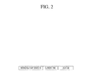
- FIG. 2 is a diagram illustrating the structure of information which is received from an infrastructure device through a V2I (Vehicle-to-Infrastructure) module.
- V2I Vehicle-to-Infrastructure
- FIG. 3 is a diagram illustrating a second location of a vehicle, which is extracted on the basis of the locations of three infrastructure devices in accordance with the embodiment of the present invention.
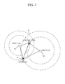
- FIG. 4 is a diagram illustrating a second location of a vehicle, which is extracted on the basis of the locations of two infrastructures in accordance with the embodiment of the present invention.
- the apparatus for implementing the method for determining the location of a vehicle in accordance with the embodiment of the present invention may include a GNSS (Global Navigation Satellite System) receiver 100, a V2I module 200, a controller 300, and a memory unit 400.
- GNSS Global Navigation Satellite System
- the GNSS receiver 100 is a device which receives location information of a vehicle with the GNSS receiver 100 from a GNSS satellite 10, and may include a GPS receiver (not illustrated) or GLONASS receiver (not illustrated) which receives location information.
- GNSS satellite 10 Since the GNSS satellite 10, a ground control system (not illustrated), and the technique for acquiring location information of a vehicle with the GNSS receiver 100 through signal transmission/reception are publicly-known, the detailed descriptions thereof are omitted herein.
- the V2I module 200 may be configured to receive information containing location information of the infrastructure device 20 from the infrastructure device 20. For example, the V2I module 200 may receive the information of the infrastructure device 20 at each predetermined period.
- the method through which the V2I module 200 and the infrastructure device 20 exchange information may include all communication methods as long as the infrastructure device 20 can communicate with a vehicle.
- Examples of the communication methods may include WAVE (Wireless Access in Vehicular Environments) communication and 3G and 4G mobile communications.
- the information received from the infrastructure device 20 through the V2I module 200 may have a structure illustrated in FIG. 2 .
- the V2I module 200 may receive information containing the location information of the infrastructure device 20 from the infrastructure device 20.
- the information may include ID (Identification) information of the infrastructure device 20, information on the time at which the infrastructure device 20 transmits the information, and the GNSS absolute location information of the infrastructure device 20.
- ID information may be used to distinguish the corresponding infrastructure device 20 from a plurality of infrastructure devices 20, when plural pieces of information are received from the respective infrastructure devices 20.
- the information received by the V2I module 200 is not limited thereto. Thus, the information may include other pieces of information.
- the controller 300 may determine the location of the vehicle based on the location information of the vehicle, received through the GNSS receiver 100, and the location information of the infrastructure device 20, received through the V2I module 200.
- the location information of the vehicle received through the GNSS receiver 100, may be referred to as first location information, and the location information of the vehicle, extracted on the basis of the location of the infrastructure device 20, may be referred to as second location information.
- the absolute location of the infrastructure device 20 as well as the first location information of the vehicle, received through the GNSS receiver 100, may be reflected to more precisely determine the location of the vehicle.
- the controller 300 may determine the location of the vehicle in different manners depending on whether the first location information of the vehicle is normally received and whether two or more infrastructure devices 20 exist within a reference distance from the vehicle.
- the reference distance may indicate a distance between the vehicle and an infrastructure device 20, at which information can be normally transmitted and received between the V2I module 200 and the infrastructure device 20.
- the reference distance may differ depending on the characteristic of the V2I module 200.
- the controller 300 may determine whether two or more infrastructure devices 20 exist within the reference distance from the vehicle.
- the controller 300 may determine the location of the vehicle according to whether the first location information of the vehicle is normally received and whether two or more infrastructure devices 20 exist. Thus, the process of determining the location of the vehicle may be divided into four cases.
- the first case is where the first location information of the vehicle is normally received and two or more infrastructure devices 20 exist within the reference distance
- the second case is where the first location information of the vehicle is normally received and two or more infrastructure devices 20 do not exist within the reference distance from the vehicle
- the third case is where the first location information of the vehicle is not normally received and two or more infrastructure devices 20 exists within the reference distance from the vehicle
- the fourth case is where the first location information of the vehicle is not normally received and two or more infrastructures 20 do not exist within the reference distance from the vehicle.
- the controller 300 may determine whether the intensity of the received first location information of the vehicle is equal to or more than reference intensity.
- the reference intensity indicates the intensity at which normal information can be considered to be contained, and may differ depending on the characteristic of the GNSS receiver 100.
- the controller 300 may ignore the corresponding information.
- the controller 300 may determine whether a location change of the vehicle per unit time based on the received first location information of the vehicle falls within a reference change, thereby determining whether the first location information of the vehicle is normally received.
- the reference change may indicate a location change of the vehicle, which may occur while the vehicle normally travels, that is, a vehicle speed.
- the reference change may differ depending on the characteristic of the vehicle.
- the controller 300 may determine that an error exists in the first location information.
- the controller 300 may not consider the corresponding location information.
- the controller 300 may correct the first location information of the vehicle by referring to the locations of the infrastructure devices 20, received through the V2I module 200.
- the controller 300 may determine the number of infrastructure devices 20 within the reference distance from the vehicle based on the information received through the V2I module 200, and extract the second location information of the vehicle based on the locations of the infrastructure devices 20.
- the controller 300 may extract the second location information of the vehicle using a triangulation method.
- the triangulation method refers to a method which measures the plane locations of points by measuring the sides or angles of a triangle.
- the controller 300 may calculate a distance between the vehicle and an infrastructure device 20 through time information contained in the information of the infrastructure device 20, received through the V2I module 200, and the time at which the information is received in the vehicle.
- the distance between the vehicle and the infrastructure device 20 may be calculated through the following formula: (information transmission speed of infrastructure device 20 ⁇
- the controller 300 may extract the GNSS absolute location information of the infrastructure device 20 through the information received from the infrastructure device 20.
- the controller 300 may extract the second location information corresponding to accurate location information of the vehicle among three infrastructure devices 20.
- the controller 300 may extract plural pieces of second information of the vehicle using information of three infrastructure devices 20, and calculate the average of the plural pieces of location information, thereby increasing the precision of the location information.
- the controller 300 may extract the second location information of the vehicle based on the traveling direction of the vehicle.
- concentric circles may be formed at the calculated distances from the two infrastructure devices 20 as illustrated in FIG. 4 , and two points A and B at which the concentric circles meet each other may become candidate points of the second location information of the vehicle.
- the controller 300 may determine which point of the two points corresponds to the initial location of the vehicle.
- the controller 300 may extract the second location information of the vehicle in such a manner.
- the controller 300 may check that the point A of the two candidate points A and B is the initial location, and thus extract the second location information of the vehicle.
- the controller 300 may calculate a location error of the vehicle based on the extracted second location information of the vehicle and the first location information of the vehicle, received through the GNSS receiver 100, and correct the first location information of the vehicle by reflecting the location error, thereby determining the precise location of the vehicle.
- the controller 300 may correct the first location information of the vehicle by referring to the most recent location of the infrastructure device 20.
- the controller 300 may reflect a location error of the vehicle, which is calculated and stored on the basis of the most recent location of the infrastructure device 20.
- the first location information of the vehicle may have a constant error from the actual location of the vehicle.
- the controller 300 may correct the first location information by reflecting the previously stored location error of the vehicle, and thus determine the precise location of the vehicle.
- the controller 300 may determine the location of the vehicle by referring to the locations of the infrastructure devices 20.
- the controller 300 may determine the location of the vehicle by reflecting only the second location information extracted on the basis of the locations of the infrastructure devices 20.
- the controller 300 may determine the location of the vehicle based on the most recent location of the vehicle and traveling information of the vehicle.
- the controller 300 may determine the location of the vehicle based on the most recent information of the vehicle.
- the controller 300 may determine the location of the vehicle by reflecting the traveling information containing the speed and direction of the vehicle, based on the location of the vehicle which is most recently stored in the memory unit 400.
- the controller 300 may calculate a difference between the current time and the time at which the most recent location of the vehicle is stored, and calculate the moving distance of the vehicle by multiplying the calculated difference by the speed of the vehicle. Then, the controller 300 may combine the moving distance with the direction information of the vehicle so as to determine the current location of the vehicle.
- the memory unit 400 may store the first location information of the vehicle, received through the GNSS receiver 100, and the information of the infrastructure device 20, received through the V2I module 200.
- the memory unit 400 may store a location error of the vehicle, which is based on the first location information and the section location information of the vehicle and calculated through the controller 300. Thus, when no infrastructure device 20 exists within the reference distance from the vehicle, the controller 300 may correct the first location information through the corresponding location error.
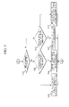
- FIG. 5 is a flowchart for explaining a process of implementing the method for determining the location of a vehicle in accordance with the embodiment of the present invention.
- FIG. 6 is a flowchart for explaining a process of determining the location of the vehicle when first location information of the vehicle is normally received and two or more infrastructure devices exist within the reference distance from the vehicle.
- FIG. 7 is a flowchart for explaining a process of determining the location of the vehicle when the first location information of the vehicle is normally received and two or more infrastructure devices do not exist within the reference distance from the vehicle.
- FIG. 8 is a flowchart for explaining a process of determining the location of the vehicle when the first location information of the vehicle is not normally received and two or more infrastructure devices exist within the reference distance from the vehicle.
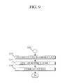
- FIG. 9 is a flowchart for explaining a process of determining the location of the vehicle when the first location information of the vehicle is not normally received and two or more infrastructure devices do not exist within the reference distance from the vehicle.
- the controller 300 may determine whether first location information of the vehicle is normally received through the GNSS receiver 100, at step S10.
- the controller 300 may determine that the first location information of the vehicle is normally received.
- the reference intensity indicates the intensity at which normal information can be considered to be contained, and may differ depending on the characteristic of the GNSS receiver 100.
- the reference change may indicate a location change of the vehicle, which may occur while the vehicle normally travels, that is, a vehicle speed.
- the reference change may differ depending on the characteristic of the vehicle.
- the controller 300 may ignore information of which the intensity is less than the reference intensity.
- the controller 300 may ignore the corresponding information.
- the controller 300 may determine whether two or more infrastructure devices 20 exist within the reference distance from the vehicle, at steps S20 and S30.
- the controller 300 may determine whether two or more infrastructure devices 20 exist within the reference distance from the vehicle.
- the controller 300 may determine the location of the vehicle in different manners, depending on whether the first location information of the vehicle is normally received and whether two or more infrastructure devices exist, at steps S40 to S70.
- the controller 300 may correct the first location information of the vehicle by referring to the locations of the infrastructure devices 20, received through the V2I module 200, at step S40.
- the controller 300 may store the first location information of the vehicle, received through the GNSS receiver 100, in the memory unit 400 at step S42, and extract the second location information of the vehicle based on the locations of the infrastructure devices 20 at step S44.
- the controller 300 may extract the location of the vehicle in different manners depending on the number of infrastructure devices 20.
- the controller 300 may extract the second location information of the vehicle using a triangulation method.
- the distance between the vehicle and an infrastructure device 20 may be calculated through the following formula: (information transmission speed of infrastructure device 20 ⁇ (current time - information transmission time of infrastructure device 20).
- the controller 300 may extract the GNSS absolute location information of the infrastructure device 20 from the information received from the infrastructure device 20. Thus, as illustrated in FIG. 3 , the controller 300 may extract the second location information as precise location information of the vehicle, corresponding to the locations of three infrastructure devices 20.
- the controller 300 may extract the second location information of the vehicle based on a location error of the vehicle.
- concentric circles may be formed at the calculated distances from the two infrastructure devices 20, and two points at which the concentric circles meet each other may become candidate points of the second location information of the vehicle.
- the controller may determine whether which points of the two points corresponds to the initial location of the vehicle.
- the controller 300 may extract the second location information of the vehicle in such a manner.
- the controller 300 may check that the point A of the two candidate points A and B is the initial position of the vehicle, and thus extract the second location information of the vehicle.
- the controller 300 may calculate a location error of the vehicle based on the extracted second information of the vehicle and the first location information of the vehicle, stored in the memory unit 400, and store the calculation result in the memory unit 400, at step S46.
- the controller 300 may correct the first location information of the vehicle by reflecting the calculated location error at step S48, thereby determining the precise location of the vehicle.
- the controller 300 may correct the first location information of the vehicle by referring the most recent location of the infrastructure device at step S50.
- the controller 300 may correct the first location information of the vehicle by referring to the location error which is calculated and stored on the basis of the most recent location of the infrastructure device 20.
- the controller 300 may store the first location information of the vehicle, received through the GNSS receiver 100, in the memory unit 400 at step S52, and correct the first location information by reflecting the location error stored in the memory unit 400 at step S54.
- the controller 300 may determine the location of the vehicle by referring to the locations of the infrastructure devices 20 at step S60.
- the controller 300 may determine the location of the vehicle by reflecting only second location information extracted on the basis of the location of the infrastructure device 20.
- the controller 300 may extract the second location information of the vehicle based on the location of the infrastructure device 20 at step S62, and determine the location of the vehicle based on the extracted second location information at step S64.
- the controller 300 may determine the location of the vehicle based on the most recent location of the vehicle and the traveling information of the vehicle, at step S70.
- the controller 300 may determine the location of the vehicle based on the most recent information of the vehicle.
- the controller 300 may extract the location information of the vehicle, which is most recently stored in the memory unit 400, at step S72, and extract the traveling information of the vehicle from an ECU (not illustrated) of the vehicle at step S74.
- controller 300 may determine the location of the vehicle by reflecting the traveling information containing the speed and direction of the vehicle based on the location information of the vehicle, which is most recently stored in the memory unit 400, at step S76.
- the controller 300 may calculate a difference between the current time and the time at which the most recent location of the vehicle is stored, and calculate the moving distance of the vehicle by multiplying the calculated difference by the speed of the vehicle. Then, the controller may combine the moving distance with the direction information of the vehicle so as to determine the current location of the vehicle.
- the fixed absolute location information of the infrastructure devices may be reflected to correct an error contained in the location information of the vehicle, received through the GNSS receiver.
- the location of the vehicle may be more precisely determined.
Landscapes
- Engineering & Computer Science (AREA)
- Radar, Positioning & Navigation (AREA)
- Remote Sensing (AREA)
- Physics & Mathematics (AREA)
- General Physics & Mathematics (AREA)
- Computer Networks & Wireless Communication (AREA)
- Automation & Control Theory (AREA)
- Navigation (AREA)
- Position Fixing By Use Of Radio Waves (AREA)
Abstract
Description
- The present application claims priority to Korean application number
10-2013-0133644, filed on November 5, 2013 - The present invention relates to a method for determining the location of a vehicle, and more particularly, to a method for determining the location of a vehicle, which is capable of more precisely determining the location of a vehicle by correcting an error contained in location information of the vehicle, received through a GNSS (Global Navigation Satellite System) receiver.
- The GNSS refers to a system which provides information on the location, altitude, and speed of an object on the earth, using a satellite orbiting the earth.
- The GNSS may provide precise location information with a resolution of 1m or less. Furthermore, the GNSS may not only be applied to the military sector, but also widely applied to private sectors which include land surveying, emergency relief, communication, and location guide of a mode of transportation such as airplane, ship, or vehicle.
- The GNSS includes one or more GNSS satellites, a GNSS receiver for receiving a signal from the GNSS satellites and a monitoring station on the earth. The GNSS receiver may receive a signal transmitted from a GNSS satellite, and determine a location based on a distance from the GNSS satellite.
- The current GNSS systems have been monopolized by the GPS (Global Positioning System) which was developed for military use by US Department of Defense in the early 1970s, in order to precisely measure the location of a specific object. Recently, however, GLONASS of Russia and Galileo of EU have been developed to cope with the GPS.
- The related art of the present invention is disclosed in Korean Patent Laid-open Publication No.
10-2011-0080677 published on July 13, 2011 - As described above, the GNSS must receive a signal from a GNSS satellite through the GNSS receiver. Thus, when a signal is not normally received from the GNSS receiver for a long time or distorted due to a natural phenomenon or interference with an electronic device of a vehicle, the reliability of the vehicle location sensed through the GNSS may be significantly degraded.
- In order to solve this problem, a technique for precisely determining the location of a vehicle by reflecting the motion of the vehicle or applying DGPS (Differential GPS) technology have been recently developed.
- However, such a conventional technique includes factors which must be additionally analyzed. The DGPS may be implemented in the environment where independent two GPS receivers are provided to communicate with each other. Furthermore, the DGPS requires various variables for calculating data and a complex calculation process.
- Embodiments of the present invention are directed to a method for determining the location of a vehicle, which is capable of correcting an error contained in location information of a vehicle, received through a GNSS receiver, by reflecting fixed absolute location information of infrastructure devices, thereby more precisely determining the location of the vehicle.
- In one embodiment, a method for determining the location of a vehicle may include: determining, by a controller, whether first location information of a vehicle is normally received through a GNSS receiver; determining whether two or more infrastructure devices exist within a reference distance from the vehicle; and determining the location of the vehicle according to whether the first location information of the vehicle is normally received and whether two or more infrastructure devices exist.
- The determining of whether the first location information of the vehicle is normally received may include: determining whether the intensity of the received first location information of the vehicle is equal to or more than reference intensity; and determining whether a location change per unit time based on the received first location information of the vehicle falls within a reference change.
- In the determining of the location of the vehicle, when the first location information of the vehicle is normally received and two or more infrastructure device exists within the reference distance from the vehicle, the controller may correct the first location information of the vehicle by referring to the locations of the infrastructure devices.
- The determining of the location of the vehicle may include: storing the first location information of the vehicle, received through the GNSS receiver; extracting second location information of the vehicle, based on the locations of the infrastructure devices; calculating and storing a location error of the vehicle based on the extracted second location information of the vehicle and the stored first location information of the vehicle; and correcting the first location information of the vehicle by reflecting the location error.
- In the extracting of the second location information of the vehicle, the controller may extract the location of the vehicle in different manners depending on the number of infrastructure devices.
- In the determining of the location of the vehicle, when the first location information of the vehicle is normally received and two or more infrastructure devices do not exist within the reference distance from the vehicle, the controller may correct the first location information of the vehicle by referring to the most recent location of the infrastructure device.
- The determining of the location of the vehicle may include: storing the first location information of the vehicle, received through the GNSS receiver; and correcting the first location information of the vehicle by reflecting the stored location error based on the most recent location of the infrastructure device.
- In the determining of the location of the vehicle, when the first location information of the vehicle is not normally received and two or more infrastructure devices exist within the reference distance from the vehicle, the controller may determine the location of the vehicle by referring to the locations of the infrastructure devices.
- The determining of the location of the vehicle may include: extracting, by the controller, second location information of the vehicle based on the locations of the infrastructure devices; and determining the location of the vehicle based on the extracted second location information.
- In the extracting of the second location information of the vehicle, the controller may extract the location of the vehicle in different manners depending on the number of infrastructure devices.
- In the determining of the location of the vehicle, when the first location information of the vehicle is not normally received and two or more infrastructure devices do not exist within the reference distance from the vehicle, the controller may determine the location of the vehicle based on traveling information of the vehicle and the location of the vehicle, which is most recently stored in a memory unit.
- In accordance with the embodiment of the present invention, the fixed absolute location information of the infrastructure devices may be reflected to correct an error contained in the location information of the vehicle, received through the GNSS receiver. Thus, the location of the vehicle may be more precisely determined.
- Furthermore, it is possible to improve the operation precision of a navigation system and various location-based applications, which guide a path using location information of a vehicle.
-
-
FIG. 1 is a function block diagram of an apparatus for implementing a method for determining the location of a vehicle in accordance with an embodiment of the present invention. -
FIG. 2 is a diagram illustrating the structure of information which is received from an infrastructure device through a V2I (Vehicle-to-Infrastructure) module. -
FIG. 3 is a diagram illustrating a second location of a vehicle, which is extracted on the basis of the locations of three infrastructure devices in accordance with the embodiment of the present invention. -
FIG. 4 is a diagram illustrating a second location of a vehicle, which is extracted on the basis of the locations of two infrastructures in accordance with the embodiment of the present invention. -
FIG. 5 is a flowchart for explaining a process of implementing the method for determining the location of a vehicle in accordance with the embodiment of the present invention. -
FIG. 6 is a flowchart for explaining a process of determining the location of the vehicle when first location information of the vehicle is normally received and two or more infrastructure devices exist within the reference distance from the vehicle. -
FIG. 7 is a flowchart for explaining a process of determining the location of the vehicle when the first location information of the vehicle is normally received and two or more infrastructure devices do not exist within the reference distance from the vehicle. -
FIG. 8 is a flowchart for explaining a process of determining the location of the vehicle when the first location information of the vehicle is not normally received and two or more infrastructure devices exist within the reference distance from the vehicle. -
FIG. 9 is a flowchart for explaining a process of determining the location of the vehicle when the first location information of the vehicle is not normally received and two or more infrastructure devices do not exist within the reference distance from the vehicle. - Embodiments of the invention will hereinafter be described in detail with reference to the accompanying drawings. It should be noted that the drawings are not to precise scale and may be exaggerated in thickness of lines or sizes of components for descriptive convenience and clarity only. Furthermore, the terms as used herein are defined by taking functions of the invention into account and can be changed according to the custom or intention of users or operators. Therefore, definition of the terms should be made according to the overall disclosures set forth herein.
-
FIG. 1 is a function block diagram of an apparatus for implementing a method for determining the location of a vehicle in accordance with an embodiment of the present invention. -
FIG. 2 is a diagram illustrating the structure of information which is received from an infrastructure device through a V2I (Vehicle-to-Infrastructure) module. -
FIG. 3 is a diagram illustrating a second location of a vehicle, which is extracted on the basis of the locations of three infrastructure devices in accordance with the embodiment of the present invention. -
FIG. 4 is a diagram illustrating a second location of a vehicle, which is extracted on the basis of the locations of two infrastructures in accordance with the embodiment of the present invention. - Referring to
FIGS. 1 to 4 , the apparatus for implementing the method for determining the location of a vehicle in accordance with the embodiment of the present invention may include a GNSS (Global Navigation Satellite System)receiver 100, aV2I module 200, acontroller 300, and amemory unit 400. - The GNSS
receiver 100 is a device which receives location information of a vehicle with the GNSSreceiver 100 from a GNSSsatellite 10, and may include a GPS receiver (not illustrated) or GLONASS receiver (not illustrated) which receives location information. - Since the GNSS
satellite 10, a ground control system (not illustrated), and the technique for acquiring location information of a vehicle with the GNSSreceiver 100 through signal transmission/reception are publicly-known, the detailed descriptions thereof are omitted herein. - The
V2I module 200 may be configured to receive information containing location information of theinfrastructure device 20 from theinfrastructure device 20. For example, theV2I module 200 may receive the information of theinfrastructure device 20 at each predetermined period. - The method through which the
V2I module 200 and theinfrastructure device 20 exchange information may include all communication methods as long as theinfrastructure device 20 can communicate with a vehicle. Examples of the communication methods may include WAVE (Wireless Access in Vehicular Environments) communication and 3G and 4G mobile communications. - Specifically, the information received from the
infrastructure device 20 through theV2I module 200 may have a structure illustrated inFIG. 2 . - Since a
location storage unit 22 of theinfrastructure device 20 stores GNSS absolute location information of the place at which theinfrastructure device 20 is installed, theV2I module 200 may receive information containing the location information of theinfrastructure device 20 from theinfrastructure device 20. - Specifically, the information may include ID (Identification) information of the
infrastructure device 20, information on the time at which theinfrastructure device 20 transmits the information, and the GNSS absolute location information of theinfrastructure device 20. The ID information may be used to distinguish thecorresponding infrastructure device 20 from a plurality ofinfrastructure devices 20, when plural pieces of information are received from therespective infrastructure devices 20. - The information received by the
V2I module 200 is not limited thereto. Thus, the information may include other pieces of information. - The
controller 300 may determine the location of the vehicle based on the location information of the vehicle, received through theGNSS receiver 100, and the location information of theinfrastructure device 20, received through theV2I module 200. - In the present embodiment, the location information of the vehicle, received through the
GNSS receiver 100, may be referred to as first location information, and the location information of the vehicle, extracted on the basis of the location of theinfrastructure device 20, may be referred to as second location information. - Furthermore, the absolute location of the
infrastructure device 20 as well as the first location information of the vehicle, received through theGNSS receiver 100, may be reflected to more precisely determine the location of the vehicle. - Specifically, the
controller 300 may determine the location of the vehicle in different manners depending on whether the first location information of the vehicle is normally received and whether two ormore infrastructure devices 20 exist within a reference distance from the vehicle. - The reference distance may indicate a distance between the vehicle and an
infrastructure device 20, at which information can be normally transmitted and received between theV2I module 200 and theinfrastructure device 20. The reference distance may differ depending on the characteristic of theV2I module 200. - In the present embodiment, when the second location information is extracted on the basis of the locations of
infrastructure devices 20, the location of the vehicle cannot be extracted through oneinfrastructure device 20. Thus, thecontroller 300 may determine whether two ormore infrastructure devices 20 exist within the reference distance from the vehicle. - As such, the
controller 300 may determine the location of the vehicle according to whether the first location information of the vehicle is normally received and whether two ormore infrastructure devices 20 exist. Thus, the process of determining the location of the vehicle may be divided into four cases. - The first case is where the first location information of the vehicle is normally received and two or
more infrastructure devices 20 exist within the reference distance, the second case is where the first location information of the vehicle is normally received and two ormore infrastructure devices 20 do not exist within the reference distance from the vehicle, the third case is where the first location information of the vehicle is not normally received and two ormore infrastructure devices 20 exists within the reference distance from the vehicle, and the fourth case is where the first location information of the vehicle is not normally received and two ormore infrastructures 20 do not exist within the reference distance from the vehicle. - Specifically, in relation to whether the first location information of the vehicle is normally received through the
GNSS receiver 100, thecontroller 300 may determine whether the intensity of the received first location information of the vehicle is equal to or more than reference intensity. - The reference intensity indicates the intensity at which normal information can be considered to be contained, and may differ depending on the characteristic of the
GNSS receiver 100. - Thus, when the intensity of the first location information of the vehicle, received through the
GNSS receiver 100, is less than the reference intensity, it may indicate that the corresponding information has low reliability. Thus, thecontroller 300 may ignore the corresponding information. - Furthermore, the
controller 300 may determine whether a location change of the vehicle per unit time based on the received first location information of the vehicle falls within a reference change, thereby determining whether the first location information of the vehicle is normally received. - The reference change may indicate a location change of the vehicle, which may occur while the vehicle normally travels, that is, a vehicle speed. The reference change may differ depending on the characteristic of the vehicle.
- For example, when the first location information of the vehicle is received at each unit time (one second) and the location change of the vehicle during the corresponding period is 100m, it may indicate that the speed of the vehicle is 100m/s. In this case, the
controller 300 may determine that an error exists in the first location information. - Thus, when the location change of the vehicle per unit time based on the first location information of the vehicle, which is periodically received, exceeds the reference change, the
controller 300 may not consider the corresponding location information. - Hereafter, a specific process of determining the location of the vehicle will be described according to whether the
controller 300 normally receives the first location information of the vehicle and whether two ormore infrastructure devices 20 exist. - First, when the first location information of the vehicle is normally received and two or
more infrastructure devices 20 exist within the reference distance from the vehicle, thecontroller 300 may correct the first location information of the vehicle by referring to the locations of theinfrastructure devices 20, received through theV2I module 200. - For this operation, the
controller 300 may determine the number ofinfrastructure devices 20 within the reference distance from the vehicle based on the information received through theV2I module 200, and extract the second location information of the vehicle based on the locations of theinfrastructure devices 20. - Specifically, when the number of
infrastructure devices 20 within the reference distance from the vehicle is three or more, thecontroller 300 may extract the second location information of the vehicle using a triangulation method. - The triangulation method refers to a method which measures the plane locations of points by measuring the sides or angles of a triangle. The
controller 300 may calculate a distance between the vehicle and aninfrastructure device 20 through time information contained in the information of theinfrastructure device 20, received through theV2I module 200, and the time at which the information is received in the vehicle. - That is, the distance between the vehicle and the
infrastructure device 20 may be calculated through the following formula: (information transmission speed ofinfrastructure device 20 × - (current time - information transmission time of infrastructure device 20).
- Furthermore, the
controller 300 may extract the GNSS absolute location information of theinfrastructure device 20 through the information received from theinfrastructure device 20. Thus, as illustrated inFIG. 3 , thecontroller 300 may extract the second location information corresponding to accurate location information of the vehicle among threeinfrastructure devices 20. - When the number of
infrastructure devices 20 within the reference distance from the vehicle is four or more, thecontroller 300 may extract plural pieces of second information of the vehicle using information of threeinfrastructure devices 20, and calculate the average of the plural pieces of location information, thereby increasing the precision of the location information. - Furthermore, when the number of
infrastructure devices 20 within the reference distance from the vehicle is two, thecontroller 300 may extract the second location information of the vehicle based on the traveling direction of the vehicle. - Specifically, when the distances between the
infrastructure devices 20 and the vehicle are calculated through the information received from the twoinfrastructure devices 20, concentric circles may be formed at the calculated distances from the twoinfrastructure devices 20 as illustrated inFIG. 4 , and two points A and B at which the concentric circles meet each other may become candidate points of the second location information of the vehicle. - Furthermore, when the traveling direction of the vehicle for the unit time is sensed, the
controller 300 may determine which point of the two points corresponds to the initial location of the vehicle. Thecontroller 300 may extract the second location information of the vehicle in such a manner. - That is, when it is determined that the vehicle travels in the forward direction as illustrated in
FIG. 4 , thecontroller 300 may check that the point A of the two candidate points A and B is the initial location, and thus extract the second location information of the vehicle. - Then, the
controller 300 may calculate a location error of the vehicle based on the extracted second location information of the vehicle and the first location information of the vehicle, received through theGNSS receiver 100, and correct the first location information of the vehicle by reflecting the location error, thereby determining the precise location of the vehicle. - Second, when the first location information of the vehicle is normally received and two or
more infrastructure devices 20 do not exist within the reference distance from the vehicle, thecontroller 300 may correct the first location information of the vehicle by referring to the most recent location of theinfrastructure device 20. - That is, when two or
more infrastructure devices 20 do not exist within the reference distance from the vehicle, the second location information based on the relative distances from theinfrastructure devices 20 cannot be extracted. Thus, thecontroller 300 may reflect a location error of the vehicle, which is calculated and stored on the basis of the most recent location of theinfrastructure device 20. - The first location information of the vehicle, received through the
GNSS receiver 100, may have a constant error from the actual location of the vehicle. Thus, thecontroller 300 may correct the first location information by reflecting the previously stored location error of the vehicle, and thus determine the precise location of the vehicle. - Third, when the first location information of the vehicle is not normally received and two or
more infrastructure devices 20 exist within the reference distance from the vehicle, thecontroller 300 may determine the location of the vehicle by referring to the locations of theinfrastructure devices 20. - That is, since the first location information of the vehicle is not normally received, the
controller 300 may determine the location of the vehicle by reflecting only the second location information extracted on the basis of the locations of theinfrastructure devices 20. - Specifically, since the process of extracting the second location information of the vehicle is performed in the same manner as described in the first case, additional descriptions are omitted herein.
- Fourth, when the first location information of the vehicle is not normally received and two or
more infrastructure devices 20 do not exist within the reference distance from the vehicle, thecontroller 300 may determine the location of the vehicle based on the most recent location of the vehicle and traveling information of the vehicle. - In such a situation, the information of the vehicle is not received from both of the
GNSS receiver 100 and theV2I module 200. Thus, thecontroller 300 may determine the location of the vehicle based on the most recent information of the vehicle. - Specifically, the
controller 300 may determine the location of the vehicle by reflecting the traveling information containing the speed and direction of the vehicle, based on the location of the vehicle which is most recently stored in thememory unit 400. - That is, the
controller 300 may calculate a difference between the current time and the time at which the most recent location of the vehicle is stored, and calculate the moving distance of the vehicle by multiplying the calculated difference by the speed of the vehicle. Then, thecontroller 300 may combine the moving distance with the direction information of the vehicle so as to determine the current location of the vehicle. - The
memory unit 400 may store the first location information of the vehicle, received through theGNSS receiver 100, and the information of theinfrastructure device 20, received through theV2I module 200. - Additionally, the
memory unit 400 may store a location error of the vehicle, which is based on the first location information and the section location information of the vehicle and calculated through thecontroller 300. Thus, when noinfrastructure device 20 exists within the reference distance from the vehicle, thecontroller 300 may correct the first location information through the corresponding location error. -
FIG. 5 is a flowchart for explaining a process of implementing the method for determining the location of a vehicle in accordance with the embodiment of the present invention. -
FIG. 6 is a flowchart for explaining a process of determining the location of the vehicle when first location information of the vehicle is normally received and two or more infrastructure devices exist within the reference distance from the vehicle. -
FIG. 7 is a flowchart for explaining a process of determining the location of the vehicle when the first location information of the vehicle is normally received and two or more infrastructure devices do not exist within the reference distance from the vehicle. -
FIG. 8 is a flowchart for explaining a process of determining the location of the vehicle when the first location information of the vehicle is not normally received and two or more infrastructure devices exist within the reference distance from the vehicle. -
FIG. 9 is a flowchart for explaining a process of determining the location of the vehicle when the first location information of the vehicle is not normally received and two or more infrastructure devices do not exist within the reference distance from the vehicle. - Referring to
FIGS. 5 to 9 , the method for determining the location of a vehicle in accordance with the embodiment of the present invention will be described. First, thecontroller 300 may determine whether first location information of the vehicle is normally received through theGNSS receiver 100, at step S10. - Specifically, when the intensity of the first location information of the vehicle, received through the
GNSS receiver 100, is equal to or more than the reference intensity and a location change per unit time based on the first location information of the vehicle falls within the reference change, thecontroller 300 may determine that the first location information of the vehicle is normally received. - The reference intensity indicates the intensity at which normal information can be considered to be contained, and may differ depending on the characteristic of the
GNSS receiver 100. The reference change may indicate a location change of the vehicle, which may occur while the vehicle normally travels, that is, a vehicle speed. The reference change may differ depending on the characteristic of the vehicle. - That is, when the intensity of the first location information of the vehicle, received through the
GNSS receiver 100, is less than the reference intensity, it may indicate that the corresponding information has low reliability. Thus, thecontroller 300 may ignore information of which the intensity is less than the reference intensity. - Furthermore, when the location change of the vehicle per unit time based on the first location information of the vehicle, which is periodically received, exceeds the reference change, the
controller 300 may ignore the corresponding information. - Then, the
controller 300 may determine whether two ormore infrastructure devices 20 exist within the reference distance from the vehicle, at steps S20 and S30. - In the present embodiment, in order to more precisely determine the location of the vehicle by referring to the locations of
infrastructure devices 20 around the vehicle as well as the first location information of the vehicle, received through theGNSS receiver 100, thecontroller 300 may determine whether two ormore infrastructure devices 20 exist within the reference distance from the vehicle. - Then, the
controller 300 may determine the location of the vehicle in different manners, depending on whether the first location information of the vehicle is normally received and whether two or more infrastructure devices exist, at steps S40 to S70. - Specifically, when the first location information of the vehicle is normally received and two or
more infrastructure devices 20 exist within the reference distance from the vehicle, thecontroller 300 may correct the first location information of the vehicle by referring to the locations of theinfrastructure devices 20, received through theV2I module 200, at step S40. - More specifically, the
controller 300 may store the first location information of the vehicle, received through theGNSS receiver 100, in thememory unit 400 at step S42, and extract the second location information of the vehicle based on the locations of theinfrastructure devices 20 at step S44. - At step S44, the
controller 300 may extract the location of the vehicle in different manners depending on the number ofinfrastructure devices 20. - Specifically, when the number of
infrastructure devices 20 within the reference distance from the vehicle is three or more, thecontroller 300 may extract the second location information of the vehicle using a triangulation method. - The distance between the vehicle and an
infrastructure device 20 may be calculated through the following formula: (information transmission speed ofinfrastructure device 20 × (current time - information transmission time of infrastructure device 20). - The
controller 300 may extract the GNSS absolute location information of theinfrastructure device 20 from the information received from theinfrastructure device 20. Thus, as illustrated inFIG. 3 , thecontroller 300 may extract the second location information as precise location information of the vehicle, corresponding to the locations of threeinfrastructure devices 20. - Furthermore, when the number of
infrastructure devices 20 within the reference distance from the vehicle is two, thecontroller 300 may extract the second location information of the vehicle based on a location error of the vehicle. - Specifically, when distances between the
infrastructure devices 20 and the vehicle are calculated through information received from the twoinfrastructure devices 20, concentric circles may be formed at the calculated distances from the twoinfrastructure devices 20, and two points at which the concentric circles meet each other may become candidate points of the second location information of the vehicle. - Furthermore, when the traveling direction of the vehicle for the unit time is sensed, the controller may determine whether which points of the two points corresponds to the initial location of the vehicle. Thus, the
controller 300 may extract the second location information of the vehicle in such a manner. - That is, when it is determined that the vehicle is traveling in the forward direction as illustrated in
FIG. 4 , thecontroller 300 may check that the point A of the two candidate points A and B is the initial position of the vehicle, and thus extract the second location information of the vehicle. - The
controller 300 may calculate a location error of the vehicle based on the extracted second information of the vehicle and the first location information of the vehicle, stored in thememory unit 400, and store the calculation result in thememory unit 400, at step S46. - Then, the
controller 300 may correct the first location information of the vehicle by reflecting the calculated location error at step S48, thereby determining the precise location of the vehicle. - On the other hand, when the first location information of the vehicle is normally received and two or
more infrastructure devices 20 do not exist within the reference distance from the vehicle, thecontroller 300 may correct the first location information of the vehicle by referring the most recent location of the infrastructure device at step S50. - That is, when two or
more infrastructure devices 20 do not exist within the reference distance from the vehicle, thecontroller 300 cannot extract the second location information based on the relative distances from theinfrastructure devices 20. Thus, thecontroller 300 may correct the first location information of the vehicle by referring to the location error which is calculated and stored on the basis of the most recent location of theinfrastructure device 20. - Specifically, the
controller 300 may store the first location information of the vehicle, received through theGNSS receiver 100, in thememory unit 400 at step S52, and correct the first location information by reflecting the location error stored in thememory unit 400 at step S54. - On the other hand, when the first location information of the vehicle is not normally received and two or
more infrastructure devices 20 exist within the reference distance from the vehicle, thecontroller 300 may determine the location of the vehicle by referring to the locations of theinfrastructure devices 20 at step S60. - In this case, since the first location information of the vehicle is not normally received, the
controller 300 may determine the location of the vehicle by reflecting only second location information extracted on the basis of the location of theinfrastructure device 20. - Specifically, the
controller 300 may extract the second location information of the vehicle based on the location of theinfrastructure device 20 at step S62, and determine the location of the vehicle based on the extracted second location information at step S64. - On the other hand, when the first location information of the vehicle is not normally received and two or
more infrastructure devices 20 do not exist within the reference distance from the vehicle, thecontroller 300 may determine the location of the vehicle based on the most recent location of the vehicle and the traveling information of the vehicle, at step S70. - In such a situation, the information of the vehicle is not received from both of the
GNSS receiver 100 and theV2I module 200. Thus, thecontroller 300 may determine the location of the vehicle based on the most recent information of the vehicle. - Specifically, the
controller 300 may extract the location information of the vehicle, which is most recently stored in thememory unit 400, at step S72, and extract the traveling information of the vehicle from an ECU (not illustrated) of the vehicle at step S74. - Furthermore, the
controller 300 may determine the location of the vehicle by reflecting the traveling information containing the speed and direction of the vehicle based on the location information of the vehicle, which is most recently stored in thememory unit 400, at step S76. - That is, the
controller 300 may calculate a difference between the current time and the time at which the most recent location of the vehicle is stored, and calculate the moving distance of the vehicle by multiplying the calculated difference by the speed of the vehicle. Then, the controller may combine the moving distance with the direction information of the vehicle so as to determine the current location of the vehicle. - In accordance with the embodiment of the present invention, the fixed absolute location information of the infrastructure devices may be reflected to correct an error contained in the location information of the vehicle, received through the GNSS receiver. Thus, the location of the vehicle may be more precisely determined.
- Furthermore, it is possible to improve the operation precision of a navigation system and various location-based applications, which guide a path using location information of a vehicle.
- Although preferred embodiments of the invention have been disclosed for illustrative purposes, those skilled in the art will appreciate that various modifications, additions and substitutions are possible, without departing from the scope and spirit of the invention as defined in the accompanying claims.
Claims (11)
- A method for determining the location of a vehicle, comprising:determining, by a controller, whether first location information of a vehicle is normally received through a GNSS (Global Navigation Satellite System) receiver;determining whether two or more infrastructure devices exist within a reference distance from the vehicle; anddetermining the location of the vehicle according to whether the first location information of the vehicle is normally received and whether two or more infrastructure devices exist.
- The method of claim 1, wherein the determining of whether the first location information of the vehicle is normally received comprises:determining whether the intensity of the received first location information of the vehicle is equal to or more than reference intensity; anddetermining whether a location change per unit time based on the received first location information of the vehicle falls within a reference change.
- The method of claim 1, wherein in the determining of the location of the vehicle,
when the first location information of the vehicle is normally received and two or more infrastructure device exists within the reference distance from the vehicle, the controller corrects the first location information of the vehicle by referring to the locations of the infrastructure devices. - The method of claim 3, wherein the determining of the location of the vehicle comprises:storing the first location information of the vehicle, received through the GNSS receiver;extracting second location information of the vehicle, based on the locations of the infrastructure devices;calculating and storing a location error of the vehicle based on the extracted second location information of the vehicle and the stored first location information of the vehicle; andcorrecting the first location information of the vehicle by reflecting the location error.
- The method of claim 4, wherein in the extracting of the second location information of the vehicle,
the controller extracts the location of the vehicle in different manners depending on the number of infrastructure devices. - The method of claim 1, wherein in the determining of the location of the vehicle,
when the first location information of the vehicle is normally received and two or more infrastructure devices do not exist within the reference distance from the vehicle, the controller corrects the first location information of the vehicle by referring to the most recent location of the infrastructure device. - The method of claim 6, wherein the determining of the location of the vehicle comprises:storing the first location information of the vehicle, received through the GNSS receiver; andcorrecting the first location information of the vehicle by reflecting the stored location error based on the most recent location of the infrastructure device.
- The method of claim 1, wherein in the determining of the location of the vehicle,
when the first location information of the vehicle is not normally received and two or more infrastructure devices exist within the reference distance from the vehicle, the controller determines the location of the vehicle by referring to the locations of the infrastructure devices. - The method of claim 8, wherein the determining of the location of the vehicle comprises:extracting, by the controller, second location information of the vehicle based on the locations of the infrastructure devices; anddetermining the location of the vehicle based on the extracted second location information.
- The method of claim 9, wherein in the extracting of the second location information of the vehicle,
the controller extracts the location of the vehicle in different manners depending on the number of infrastructure devices. - The method of claim 1, wherein in the determining of the location of the vehicle,
when the first location information of the vehicle is not normally received and two or more infrastructure devices do not exist within the reference distance from the vehicle, the controller determines the location of the vehicle based on traveling information of the vehicle and the location of the vehicle, which is most recently stored in a memory unit.
Applications Claiming Priority (1)
| Application Number | Priority Date | Filing Date | Title |
|---|---|---|---|
| KR1020130133644A KR102263185B1 (en) | 2013-11-05 | 2013-11-05 | Method for determining location of vehicle |
Publications (3)
| Publication Number | Publication Date |
|---|---|
| EP2876463A2 true EP2876463A2 (en) | 2015-05-27 |
| EP2876463A3 EP2876463A3 (en) | 2015-09-16 |
| EP2876463B1 EP2876463B1 (en) | 2020-04-01 |
Family
ID=51659510
Family Applications (1)
| Application Number | Title | Priority Date | Filing Date |
|---|---|---|---|
| EP14187004.8A Active EP2876463B1 (en) | 2013-11-05 | 2014-09-30 | Method for determining location of vehicle |
Country Status (4)
| Country | Link |
|---|---|
| US (1) | US9207086B2 (en) |
| EP (1) | EP2876463B1 (en) |
| KR (1) | KR102263185B1 (en) |
| CN (1) | CN104614750B (en) |
Families Citing this family (15)
| Publication number | Priority date | Publication date | Assignee | Title |
|---|---|---|---|---|
| KR101795381B1 (en) * | 2015-11-20 | 2017-11-09 | 현대자동차 주식회사 | System and method of sharing for vehicle position information, and computer readable medium recording the method |
| US9913104B2 (en) * | 2016-01-21 | 2018-03-06 | General Motors Llc | Vehicle location services |
| EP3506238A4 (en) * | 2016-08-26 | 2019-11-27 | Panasonic Intellectual Property Corporation of America | METHOD FOR PROCESSING THREE-DIMENSIONAL INFORMATION AND APPARATUS FOR PROCESSING THREE-DIMENSIONAL INFORMATION |
| CN109983487B (en) * | 2016-11-21 | 2024-05-14 | 福特全球技术公司 | Article delivery to unattended vehicles |
| US10094906B2 (en) * | 2016-12-22 | 2018-10-09 | GM Global Technology Operations LLC | Vehicle positioning system using V2X, sensor, and GNSS information |
| CN108059107A (en) * | 2017-12-15 | 2018-05-22 | 武汉华志机器人产业技术研究院有限公司 | Method, apparatus and system based on earth station's lifting target vehicle |
| CN108033382A (en) * | 2017-12-15 | 2018-05-15 | 武汉华志机器人产业技术研究院有限公司 | Target vehicle carries out the method, apparatus and system of lifting based on earth station |
| CN108810155B (en) * | 2018-06-19 | 2020-11-03 | 中国科学院光电研究院 | A method and system for evaluating the reliability of vehicle location information in the Internet of Vehicles |
| CN111212375B (en) | 2018-11-20 | 2021-08-03 | 华为技术有限公司 | Positioning position adjustment method and device thereof |
| KR102757213B1 (en) * | 2018-12-28 | 2025-01-21 | 현대자동차주식회사 | Vehicle and control mtehod thereof |
| US11035679B2 (en) | 2019-01-04 | 2021-06-15 | Ford Global Technologies, Llc | Localization technique |
| JP7582736B2 (en) * | 2019-10-08 | 2024-11-13 | モービルアイ ビジョン テクノロジーズ リミテッド | System, method and program for vehicle navigation |
| CN112509297B (en) * | 2020-09-28 | 2022-07-26 | 国网浙江杭州市余杭区供电有限公司 | Intelligent monitoring method and device for preventing transmission line from being broken outside |
| KR102617409B1 (en) * | 2021-04-28 | 2023-12-27 | 주식회사 엘지유플러스 | Method for correcting positioning information |
| CN115824231B (en) * | 2023-02-22 | 2023-04-28 | 安徽阿瑞特汽车电子科技有限公司 | Intelligent positioning management system for automobile running |
Citations (1)
| Publication number | Priority date | Publication date | Assignee | Title |
|---|---|---|---|---|
| KR20110080677A (en) | 2010-01-06 | 2011-07-13 | 주식회사 금영 | Vehicle position prediction system according to GPS reception failure and position prediction method using same |
Family Cites Families (10)
| Publication number | Priority date | Publication date | Assignee | Title |
|---|---|---|---|---|
| US5982324A (en) * | 1998-05-14 | 1999-11-09 | Nortel Networks Corporation | Combining GPS with TOA/TDOA of cellular signals to locate terminal |
| US6166685A (en) * | 1998-11-19 | 2000-12-26 | Qualcomm Incorporated | Wireless user position update using infrastructure measurements |
| JP2001174537A (en) * | 1999-12-21 | 2001-06-29 | Hitachi Ltd | Wireless terminal position measuring method and terminal device using the same |
| US7551931B2 (en) * | 2001-01-24 | 2009-06-23 | Motorola, Inc. | Method and system for validating a mobile station location fix |
| JP2006017592A (en) * | 2004-07-01 | 2006-01-19 | Japan Radio Co Ltd | Positioning information device and down converter IC |
| DE102007054509A1 (en) * | 2007-11-15 | 2009-05-20 | Robert Bosch Gmbh | Method for determining a position of a vehicle |
| US8583199B2 (en) * | 2011-04-07 | 2013-11-12 | General Motors Llc | Telematics systems and methods with multiple antennas |
| DE102011118161B3 (en) * | 2011-11-10 | 2013-03-28 | Audi Ag | Method for determining position |
| US8521427B1 (en) * | 2012-11-28 | 2013-08-27 | The Boeing Company | Vehicle navigation using cellular networks |
| CN103018758A (en) * | 2012-12-03 | 2013-04-03 | 东南大学 | Method for moving differential base station based on global positioning system (GPS)/inertial navigation system (INS)/assisted global positioning system (AGPS) |
-
2013
- 2013-11-05 KR KR1020130133644A patent/KR102263185B1/en active Active
-
2014
- 2014-08-13 CN CN201410397408.7A patent/CN104614750B/en active Active
- 2014-08-21 US US14/465,735 patent/US9207086B2/en active Active
- 2014-09-30 EP EP14187004.8A patent/EP2876463B1/en active Active
Patent Citations (1)
| Publication number | Priority date | Publication date | Assignee | Title |
|---|---|---|---|---|
| KR20110080677A (en) | 2010-01-06 | 2011-07-13 | 주식회사 금영 | Vehicle position prediction system according to GPS reception failure and position prediction method using same |
Also Published As
| Publication number | Publication date |
|---|---|
| US9207086B2 (en) | 2015-12-08 |
| EP2876463A3 (en) | 2015-09-16 |
| CN104614750B (en) | 2017-06-23 |
| KR102263185B1 (en) | 2021-06-10 |
| KR20150051747A (en) | 2015-05-13 |
| US20150127250A1 (en) | 2015-05-07 |
| EP2876463B1 (en) | 2020-04-01 |
| CN104614750A (en) | 2015-05-13 |
Similar Documents
| Publication | Publication Date | Title |
|---|---|---|
| EP2876463B1 (en) | Method for determining location of vehicle | |
| US11808863B2 (en) | Methods and systems for location determination | |
| EP2902748B1 (en) | Vehicle position calibration method and corresponding apparatus | |
| US10928834B2 (en) | Autonomous vehicle localization using 5G infrastructure | |
| US9720071B2 (en) | Mitigating effects of multipath during position computation | |
| US11061143B2 (en) | Global navigation satellite system, navigation terminal, navigation method and program | |
| US9465099B2 (en) | Method for measuring position of vehicle using cloud computing | |
| US10816675B2 (en) | Coordinate output method and coordinate output device | |
| WO2018052740A1 (en) | Repair of carrier-phase cycle slips using displacement data | |
| US20130257651A1 (en) | Navigation bit boundary determination apparatus and a method therefor | |
| KR101605357B1 (en) | Method for measuring position and positioning apparatus therefor | |
| KR20110135809A (en) | Precision positioning device and method using wireless Ap | |
| KR20120131093A (en) | Positioning method of GPS receiver, Recording medium storing a program for performing the method and GPS receiver | |
| JP2022545327A (en) | Increase sensitivity to reflected GNSS signals | |
| CN112904390A (en) | Positioning method, positioning device, computer equipment and storage medium | |
| KR20040072448A (en) | Apparatus and method for calculating satellite acquisition information to measure position of mobile station | |
| AU2022204823A1 (en) | Reliability determination of location updates in multipath environments | |
| US11294072B2 (en) | Method, device and server for estimation of IFB calibration value | |
| KR102584796B1 (en) | Method and apparatus for location estimating using gis information | |
| KR101582840B1 (en) | System for determining reliability level of GPS information and providing method thereof | |
| CN115585807B (en) | GNSS/INS integrated navigation method based on machine learning | |
| KR20150084725A (en) | Precision positioning apparatus and method utilizing virtual reference station by wireless access point | |
| EP3916430B1 (en) | Single delta range differences using synthetic clock steering | |
| KR20170141341A (en) | Distance detection apparatus and distance detection method | |
| KR20180102365A (en) | Position data correct method using beacon signal |
Legal Events
| Date | Code | Title | Description |
|---|---|---|---|
| PUAI | Public reference made under article 153(3) epc to a published international application that has entered the european phase |
Free format text: ORIGINAL CODE: 0009012 |
|
| 17P | Request for examination filed |
Effective date: 20140930 |
|
| AK | Designated contracting states |
Kind code of ref document: A2 Designated state(s): AL AT BE BG CH CY CZ DE DK EE ES FI FR GB GR HR HU IE IS IT LI LT LU LV MC MK MT NL NO PL PT RO RS SE SI SK SM TR |
|
| AX | Request for extension of the european patent |
Extension state: BA ME |
|
| PUAL | Search report despatched |
Free format text: ORIGINAL CODE: 0009013 |
|
| AK | Designated contracting states |
Kind code of ref document: A3 Designated state(s): AL AT BE BG CH CY CZ DE DK EE ES FI FR GB GR HR HU IE IS IT LI LT LU LV MC MK MT NL NO PL PT RO RS SE SI SK SM TR |
|
| AX | Request for extension of the european patent |
Extension state: BA ME |
|
| RIC1 | Information provided on ipc code assigned before grant |
Ipc: G01S 19/48 20100101AFI20150813BHEP Ipc: G01S 19/49 20100101ALI20150813BHEP |
|
| RBV | Designated contracting states (corrected) |
Designated state(s): AL AT BE BG CH CY CZ DE DK EE ES FI FR GB GR HR HU IE IS IT LI LT LU LV MC MK MT NL NO PL PT RO RS SE SI SK SM TR |
|
| STAA | Information on the status of an ep patent application or granted ep patent |
Free format text: STATUS: EXAMINATION IS IN PROGRESS |
|
| 17Q | First examination report despatched |
Effective date: 20180222 |
|
| RIC1 | Information provided on ipc code assigned before grant |
Ipc: G01S 19/13 20100101ALI20191023BHEP Ipc: G01S 19/48 20100101AFI20191023BHEP Ipc: G01S 19/49 20100101ALI20191023BHEP Ipc: G01C 21/20 20060101ALI20191023BHEP |
|
| GRAP | Despatch of communication of intention to grant a patent |
Free format text: ORIGINAL CODE: EPIDOSNIGR1 |
|
| STAA | Information on the status of an ep patent application or granted ep patent |
Free format text: STATUS: GRANT OF PATENT IS INTENDED |
|
| INTG | Intention to grant announced |
Effective date: 20191206 |
|
| RAP1 | Party data changed (applicant data changed or rights of an application transferred) |
Owner name: HYUNDAI MOBIS CO., LTD. |
|
| GRAS | Grant fee paid |
Free format text: ORIGINAL CODE: EPIDOSNIGR3 |
|
| GRAA | (expected) grant |
Free format text: ORIGINAL CODE: 0009210 |
|
| STAA | Information on the status of an ep patent application or granted ep patent |
Free format text: STATUS: THE PATENT HAS BEEN GRANTED |
|
| AK | Designated contracting states |
Kind code of ref document: B1 Designated state(s): AL AT BE BG CH CY CZ DE DK EE ES FI FR GB GR HR HU IE IS IT LI LT LU LV MC MK MT NL NO PL PT RO RS SE SI SK SM TR |
|
| REG | Reference to a national code |
Ref country code: GB Ref legal event code: FG4D |
|
| REG | Reference to a national code |
Ref country code: CH Ref legal event code: EP Ref country code: AT Ref legal event code: REF Ref document number: 1252090 Country of ref document: AT Kind code of ref document: T Effective date: 20200415 |
|
| REG | Reference to a national code |
Ref country code: DE Ref legal event code: R096 Ref document number: 602014063082 Country of ref document: DE |
|
| REG | Reference to a national code |
Ref country code: IE Ref legal event code: FG4D |
|
| PG25 | Lapsed in a contracting state [announced via postgrant information from national office to epo] |
Ref country code: BG Free format text: LAPSE BECAUSE OF FAILURE TO SUBMIT A TRANSLATION OF THE DESCRIPTION OR TO PAY THE FEE WITHIN THE PRESCRIBED TIME-LIMIT Effective date: 20200701 |
|
| REG | Reference to a national code |
Ref country code: NL Ref legal event code: MP Effective date: 20200401 |
|
| REG | Reference to a national code |
Ref country code: LT Ref legal event code: MG4D |
|
| PG25 | Lapsed in a contracting state [announced via postgrant information from national office to epo] |
Ref country code: NO Free format text: LAPSE BECAUSE OF FAILURE TO SUBMIT A TRANSLATION OF THE DESCRIPTION OR TO PAY THE FEE WITHIN THE PRESCRIBED TIME-LIMIT Effective date: 20200701 Ref country code: FI Free format text: LAPSE BECAUSE OF FAILURE TO SUBMIT A TRANSLATION OF THE DESCRIPTION OR TO PAY THE FEE WITHIN THE PRESCRIBED TIME-LIMIT Effective date: 20200401 Ref country code: GR Free format text: LAPSE BECAUSE OF FAILURE TO SUBMIT A TRANSLATION OF THE DESCRIPTION OR TO PAY THE FEE WITHIN THE PRESCRIBED TIME-LIMIT Effective date: 20200702 Ref country code: PT Free format text: LAPSE BECAUSE OF FAILURE TO SUBMIT A TRANSLATION OF THE DESCRIPTION OR TO PAY THE FEE WITHIN THE PRESCRIBED TIME-LIMIT Effective date: 20200817 Ref country code: IS Free format text: LAPSE BECAUSE OF FAILURE TO SUBMIT A TRANSLATION OF THE DESCRIPTION OR TO PAY THE FEE WITHIN THE PRESCRIBED TIME-LIMIT Effective date: 20200801 Ref country code: SE Free format text: LAPSE BECAUSE OF FAILURE TO SUBMIT A TRANSLATION OF THE DESCRIPTION OR TO PAY THE FEE WITHIN THE PRESCRIBED TIME-LIMIT Effective date: 20200401 Ref country code: NL Free format text: LAPSE BECAUSE OF FAILURE TO SUBMIT A TRANSLATION OF THE DESCRIPTION OR TO PAY THE FEE WITHIN THE PRESCRIBED TIME-LIMIT Effective date: 20200401 Ref country code: CZ Free format text: LAPSE BECAUSE OF FAILURE TO SUBMIT A TRANSLATION OF THE DESCRIPTION OR TO PAY THE FEE WITHIN THE PRESCRIBED TIME-LIMIT Effective date: 20200401 Ref country code: LT Free format text: LAPSE BECAUSE OF FAILURE TO SUBMIT A TRANSLATION OF THE DESCRIPTION OR TO PAY THE FEE WITHIN THE PRESCRIBED TIME-LIMIT Effective date: 20200401 |
|
| REG | Reference to a national code |
Ref country code: AT Ref legal event code: MK05 Ref document number: 1252090 Country of ref document: AT Kind code of ref document: T Effective date: 20200401 |
|
| PG25 | Lapsed in a contracting state [announced via postgrant information from national office to epo] |
Ref country code: RS Free format text: LAPSE BECAUSE OF FAILURE TO SUBMIT A TRANSLATION OF THE DESCRIPTION OR TO PAY THE FEE WITHIN THE PRESCRIBED TIME-LIMIT Effective date: 20200401 Ref country code: LV Free format text: LAPSE BECAUSE OF FAILURE TO SUBMIT A TRANSLATION OF THE DESCRIPTION OR TO PAY THE FEE WITHIN THE PRESCRIBED TIME-LIMIT Effective date: 20200401 Ref country code: HR Free format text: LAPSE BECAUSE OF FAILURE TO SUBMIT A TRANSLATION OF THE DESCRIPTION OR TO PAY THE FEE WITHIN THE PRESCRIBED TIME-LIMIT Effective date: 20200401 |
|
| PG25 | Lapsed in a contracting state [announced via postgrant information from national office to epo] |
Ref country code: AL Free format text: LAPSE BECAUSE OF FAILURE TO SUBMIT A TRANSLATION OF THE DESCRIPTION OR TO PAY THE FEE WITHIN THE PRESCRIBED TIME-LIMIT Effective date: 20200401 |
|
| REG | Reference to a national code |
Ref country code: DE Ref legal event code: R097 Ref document number: 602014063082 Country of ref document: DE |
|
| PG25 | Lapsed in a contracting state [announced via postgrant information from national office to epo] |
Ref country code: ES Free format text: LAPSE BECAUSE OF FAILURE TO SUBMIT A TRANSLATION OF THE DESCRIPTION OR TO PAY THE FEE WITHIN THE PRESCRIBED TIME-LIMIT Effective date: 20200401 Ref country code: DK Free format text: LAPSE BECAUSE OF FAILURE TO SUBMIT A TRANSLATION OF THE DESCRIPTION OR TO PAY THE FEE WITHIN THE PRESCRIBED TIME-LIMIT Effective date: 20200401 Ref country code: IT Free format text: LAPSE BECAUSE OF FAILURE TO SUBMIT A TRANSLATION OF THE DESCRIPTION OR TO PAY THE FEE WITHIN THE PRESCRIBED TIME-LIMIT Effective date: 20200401 Ref country code: AT Free format text: LAPSE BECAUSE OF FAILURE TO SUBMIT A TRANSLATION OF THE DESCRIPTION OR TO PAY THE FEE WITHIN THE PRESCRIBED TIME-LIMIT Effective date: 20200401 Ref country code: SM Free format text: LAPSE BECAUSE OF FAILURE TO SUBMIT A TRANSLATION OF THE DESCRIPTION OR TO PAY THE FEE WITHIN THE PRESCRIBED TIME-LIMIT Effective date: 20200401 Ref country code: EE Free format text: LAPSE BECAUSE OF FAILURE TO SUBMIT A TRANSLATION OF THE DESCRIPTION OR TO PAY THE FEE WITHIN THE PRESCRIBED TIME-LIMIT Effective date: 20200401 Ref country code: RO Free format text: LAPSE BECAUSE OF FAILURE TO SUBMIT A TRANSLATION OF THE DESCRIPTION OR TO PAY THE FEE WITHIN THE PRESCRIBED TIME-LIMIT Effective date: 20200401 |
|
| PLBE | No opposition filed within time limit |
Free format text: ORIGINAL CODE: 0009261 |
|
| STAA | Information on the status of an ep patent application or granted ep patent |
Free format text: STATUS: NO OPPOSITION FILED WITHIN TIME LIMIT |
|
| PG25 | Lapsed in a contracting state [announced via postgrant information from national office to epo] |
Ref country code: SK Free format text: LAPSE BECAUSE OF FAILURE TO SUBMIT A TRANSLATION OF THE DESCRIPTION OR TO PAY THE FEE WITHIN THE PRESCRIBED TIME-LIMIT Effective date: 20200401 Ref country code: PL Free format text: LAPSE BECAUSE OF FAILURE TO SUBMIT A TRANSLATION OF THE DESCRIPTION OR TO PAY THE FEE WITHIN THE PRESCRIBED TIME-LIMIT Effective date: 20200401 |
|
| 26N | No opposition filed |
Effective date: 20210112 |
|
| PG25 | Lapsed in a contracting state [announced via postgrant information from national office to epo] |
Ref country code: MC Free format text: LAPSE BECAUSE OF FAILURE TO SUBMIT A TRANSLATION OF THE DESCRIPTION OR TO PAY THE FEE WITHIN THE PRESCRIBED TIME-LIMIT Effective date: 20200401 |
|
| REG | Reference to a national code |
Ref country code: CH Ref legal event code: PL |
|
| PG25 | Lapsed in a contracting state [announced via postgrant information from national office to epo] |
Ref country code: SI Free format text: LAPSE BECAUSE OF FAILURE TO SUBMIT A TRANSLATION OF THE DESCRIPTION OR TO PAY THE FEE WITHIN THE PRESCRIBED TIME-LIMIT Effective date: 20200401 |
|
| REG | Reference to a national code |
Ref country code: BE Ref legal event code: MM Effective date: 20200930 |
|
| PG25 | Lapsed in a contracting state [announced via postgrant information from national office to epo] |
Ref country code: LU Free format text: LAPSE BECAUSE OF NON-PAYMENT OF DUE FEES Effective date: 20200930 |
|
| PG25 | Lapsed in a contracting state [announced via postgrant information from national office to epo] |
Ref country code: IE Free format text: LAPSE BECAUSE OF NON-PAYMENT OF DUE FEES Effective date: 20200930 Ref country code: LI Free format text: LAPSE BECAUSE OF NON-PAYMENT OF DUE FEES Effective date: 20200930 Ref country code: BE Free format text: LAPSE BECAUSE OF NON-PAYMENT OF DUE FEES Effective date: 20200930 Ref country code: CH Free format text: LAPSE BECAUSE OF NON-PAYMENT OF DUE FEES Effective date: 20200930 |
|
| PG25 | Lapsed in a contracting state [announced via postgrant information from national office to epo] |
Ref country code: TR Free format text: LAPSE BECAUSE OF FAILURE TO SUBMIT A TRANSLATION OF THE DESCRIPTION OR TO PAY THE FEE WITHIN THE PRESCRIBED TIME-LIMIT Effective date: 20200401 Ref country code: MT Free format text: LAPSE BECAUSE OF FAILURE TO SUBMIT A TRANSLATION OF THE DESCRIPTION OR TO PAY THE FEE WITHIN THE PRESCRIBED TIME-LIMIT Effective date: 20200401 Ref country code: CY Free format text: LAPSE BECAUSE OF FAILURE TO SUBMIT A TRANSLATION OF THE DESCRIPTION OR TO PAY THE FEE WITHIN THE PRESCRIBED TIME-LIMIT Effective date: 20200401 |
|
| PG25 | Lapsed in a contracting state [announced via postgrant information from national office to epo] |
Ref country code: MK Free format text: LAPSE BECAUSE OF FAILURE TO SUBMIT A TRANSLATION OF THE DESCRIPTION OR TO PAY THE FEE WITHIN THE PRESCRIBED TIME-LIMIT Effective date: 20200401 |
|
| P01 | Opt-out of the competence of the unified patent court (upc) registered |
Effective date: 20230530 |
|
| PGFP | Annual fee paid to national office [announced via postgrant information from national office to epo] |
Ref country code: DE Payment date: 20250721 Year of fee payment: 12 |
|
| PGFP | Annual fee paid to national office [announced via postgrant information from national office to epo] |
Ref country code: GB Payment date: 20250722 Year of fee payment: 12 |
|
| PGFP | Annual fee paid to national office [announced via postgrant information from national office to epo] |
Ref country code: FR Payment date: 20250725 Year of fee payment: 12 |