EP2864822B1 - Saturation estimation using mcsem data and stochastic petrophysical modeling - Google Patents
Saturation estimation using mcsem data and stochastic petrophysical modeling Download PDFInfo
- Publication number
- EP2864822B1 EP2864822B1 EP12733020.7A EP12733020A EP2864822B1 EP 2864822 B1 EP2864822 B1 EP 2864822B1 EP 12733020 A EP12733020 A EP 12733020A EP 2864822 B1 EP2864822 B1 EP 2864822B1
- Authority
- EP
- European Patent Office
- Prior art keywords
- saturation
- reservoir
- mcsem
- resistivity
- equation
- Prior art date
- Legal status (The legal status is an assumption and is not a legal conclusion. Google has not performed a legal analysis and makes no representation as to the accuracy of the status listed.)
- Active
Links
Images


Classifications
-
- G—PHYSICS
- G01—MEASURING; TESTING
- G01V—GEOPHYSICS; GRAVITATIONAL MEASUREMENTS; DETECTING MASSES OR OBJECTS; TAGS
- G01V3/00—Electric or magnetic prospecting or detecting; Measuring magnetic field characteristics of the earth, e.g. declination, deviation
- G01V3/08—Electric or magnetic prospecting or detecting; Measuring magnetic field characteristics of the earth, e.g. declination, deviation operating with magnetic or electric fields produced or modified by objects or geological structures or by detecting devices
- G01V3/083—Controlled source electromagnetic [CSEM] surveying
-
- Y—GENERAL TAGGING OF NEW TECHNOLOGICAL DEVELOPMENTS; GENERAL TAGGING OF CROSS-SECTIONAL TECHNOLOGIES SPANNING OVER SEVERAL SECTIONS OF THE IPC; TECHNICAL SUBJECTS COVERED BY FORMER USPC CROSS-REFERENCE ART COLLECTIONS [XRACs] AND DIGESTS
- Y02—TECHNOLOGIES OR APPLICATIONS FOR MITIGATION OR ADAPTATION AGAINST CLIMATE CHANGE
- Y02A—TECHNOLOGIES FOR ADAPTATION TO CLIMATE CHANGE
- Y02A90/00—Technologies having an indirect contribution to adaptation to climate change
- Y02A90/30—Assessment of water resources
Definitions
- the present invention relates generally to the field of exploration geophysics and the characterization of potential hydrocarbon reservoirs. More specifically, the invention relates to processing techniques for the estimation of water and hydrocarbon saturation in subsea geological formations using marine controlled-source electromagnetic (mCSEM) data and stochastic petrophysical modeling.
- mCSEM marine controlled-source electromagnetic
- CSEM Controlled-source electromagnetic
- MT magnetotelluric
- a mCSEM system comprises an electromagnetic sender, or antenna, that is either towed from a vessel, stationary in the body of water or on the seabed, and likewise a plurality of electromagnetic receivers that are either placed at known locations on the seabed or towed from a vessel or stationary in the body of water.
- the receivers can detect variations in electrical resistance as a function of variations in source signal, offset between the source and receiver and the properties of the geological layers, including their inherent electrical conductive properties. For instance, a hydrocarbon layer will exhibit a higher electrical resistance, ca. 20-300 ohm-m, than either seawater, ca. 0.3 ohm-m, or an overburden of sediment or rock, ca. 0.3-4 ohm-m.
- the acronyms CSEM or mCSEM are generally used interchangeably by those skilled in the art, and are not meant to be delimiting in any technical sense, unless explicitly specified.
- resistivity or resistance are also used interchangeably by those skilled in the art, and are not meant to be delimiting in any technical sense, unless explicitly specified.
- Inversion processing techniques have been developed in step with instrumentation, whereby the aim of the inversion is to optimize the parameters of a model to find the best fit between the calculated value and the measured data whereby the measured data can be used to constrain models.
- Archie's equation is an empirical quantitative relationship between porosity, electrical conductivity, and brine saturation of rocks. The equation is a basis for modern well log interpretation as it relates borehole electrical conductivity measurements to hydrocarbon saturations.
- S w a / ⁇ m * R w / R t 1 / n
- This invention aims at quantifying the average water saturation in a reservoir given the transverse resistance obtained from mCSEM data.
- the invention can be described by the following workflow comprising 3 main steps:
- Step 1 is defined by the sub-steps: inversion of measured mCSEM data and TR-anomaly determination.
- Measured mCSEM survey data are obtained for a subsurface region of interest. Inversions are then performed on the measured mCSEM survey data for the subsurface region.
- the anomaly assumed to be associated with the reservoir is located, and separated from the background resistivity trend. By location, it is meant geographic location on the seabed and vertical depth under the seabed.
- the difference from the background inversion forms the anomalous TR associated with the reservoir to be used in combination with the petrophysical model (step 2).
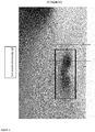
- Figure 1 shows an example of lower dimensional 2.5D mCSEM inversion result.
- the middle rectangle shows an anomaly associated with the reservoir, the black line shows a "well” through the anomaly and the grey line shows a "well” outside of the anomaly.
- the dotted line (G) is a well outside the reservoir from 2.5D unconstrained inversion
- the dash-dotted line (1) is an unconstrained 2.5D inversion through the reservoir.
- the TR is assumed to be due to the lithology/fluid content of the reservoir.
- the dashed line (2) is a constrained 2.5D inversion through the reservoir with a correction due to the lower dimensional 2.5D assumption included.
- the difference between the line (G) and one of the other two (1or 2) defines the transverse resistance (TR) when integrated over the relevant depths, here approximately 500 m.
- TR transverse resistance
- Step 2 is defined by the sub-steps: average saturation estimation, stochastic petrophysical modeling and incorporation of parameter uncertainties.
- TR is in particular mainly dependent on the following reservoir parameters:
- Figure 3 shows a typical output from the stochastic petrophysical model. It shows the average weighted water saturation ( ⁇ Sw>/ ⁇ > [v/v]) on the x-axis versus the logarithm of TR (log 10 ( ⁇ ⁇ z R v [Ohm-m 2 ])) on the y-axis, where the individual pixels show how many samples from a Monte Carlo sampling have ended up in the given positions. The Monte Carlo simulation is performed to sample the total space defined by the uncertainties of the parameters.
- Figure 3 is based on the Monte Carlo sampling and Archie's equation, although optionally, other equations than Archie's equation may be used instead for the resistivity-saturation relation.
- the parameters in a petrophysical resistivity-saturation relation are not exactly known, but a probability distribution can be assigned to them.
- the cementation factor "m” can for example be normally distributed with expectation "2" and a standard deviation.
- the saturation exponent "n” can also be normally distributed with an expectation "2" and standard deviation.
- the water resistivity can for example be assigned a flat probability distribution from the minimum expected salinity to the maximum expected salinity and combined with the assumed temperature profile.
- Other alternatives to Archie's equation can also be applied. Any petrophysical relation connecting a suitable set of petrophysical parameters, a subset of which is listed above, to resistivity can be used.
- Examples are the Indonesia equation, the Simandoux equation, Waxman-Smit and the dual water equation.
- the above mentioned models take into account the added conductivity along clay surfaces in different manners.
- the average porosity in the reservoir can be assigned from prospect risking. However within each reservoir there is a variation in porosity which has to be included.
- the assumed porosity variation within the reservoir can be estimated by a truncated probability distribution where the truncation limits are the minimum reservoir porosity (porosity cutoff) to the maximum reservoir porosity (estimated from burial depth and experience), but the expectation should correspond to the prospect risking. From experience, porosity and saturation often are correlated. Low porosity often corresponds with higher water saturation due to more capillary bound water.
- This correlation can be incorporated by including a covariance between porosity and saturation.
- the stochastic petrophysical simulation samples parameter values from the respective probability density functions by Monte-Carlo simulation and constructs the resistivity-saturation relation for each possible set of reservoir parameters. After connecting the possible reservoir resistivity values in a series connection and calculating the transverse resistance, a distribution of possible saturation - transverse resistance relations is found.
- Step 3 is defined by the sub-steps: integration of TR distribution and a final estimate of the saturation probability distribution.
- Figure 4 shows such a probability distribution (up to a constant) after integrating the distribution in Figure 3 over the TR range specified from mCSEM inversion results with weights reflecting the probabilities for each TR.
- the horizontal x-axis represents the weighted average water saturation ( ⁇ Sw>/ ⁇ > [v/v]).
- the present method is an approach for estimating saturation using mCSEM data and stochastic petrophysical models by quantifying the average water saturation in a reservoir given the transverse resistance (TR) obtained from mCSEM data.
- TR transverse resistance
- the TR of interest is that associated with the vertical resistivity, as mCSEM is not sensitive to the horizontal resistivity within the reservoir.
- mCSEM data are known to be more sensitive to TR than the exact depth and value of the resistivity, this is more robust than the existing workflow.
- the method is implemented as a stochastic method, which naturally incorporates the associated uncertainties of both input and output. It may be necessary to consider a depth range larger than a seismic outline of the prospect when calculating the TR, due to the low resolution of mCSEM and uncertainty of depth position of resistivity.
Description
- The present invention relates generally to the field of exploration geophysics and the characterization of potential hydrocarbon reservoirs. More specifically, the invention relates to processing techniques for the estimation of water and hydrocarbon saturation in subsea geological formations using marine controlled-source electromagnetic (mCSEM) data and stochastic petrophysical modeling.
- The procurement and inversion of electromagnetic data has in recent years become a valuable tool in assessing the potential specific geophysical formations. Controlled-source electromagnetic (CSEM) data is often combined with other measurement data, such as seismic, gravity gradiometry, magnetotelluric (MT) or perhaps nearby well-logs to mention a few. In most mCSEM surveying applications, a mCSEM system comprises an electromagnetic sender, or antenna, that is either towed from a vessel, stationary in the body of water or on the seabed, and likewise a plurality of electromagnetic receivers that are either placed at known locations on the seabed or towed from a vessel or stationary in the body of water. The receivers can detect variations in electrical resistance as a function of variations in source signal, offset between the source and receiver and the properties of the geological layers, including their inherent electrical conductive properties. For instance, a hydrocarbon layer will exhibit a higher electrical resistance, ca. 20-300 ohm-m, than either seawater, ca. 0.3 ohm-m, or an overburden of sediment or rock, ca. 0.3-4 ohm-m. The acronyms CSEM or mCSEM are generally used interchangeably by those skilled in the art, and are not meant to be delimiting in any technical sense, unless explicitly specified. The terms resistivity or resistance are also used interchangeably by those skilled in the art, and are not meant to be delimiting in any technical sense, unless explicitly specified. The various types of measurement methods, due to their inherent designs, often acquire data with different temporal and spatial scales. As these data sets have increased in size and complexity, the challenges in processing such large data sets has also increased. Inversion processing techniques have been developed in step with instrumentation, whereby the aim of the inversion is to optimize the parameters of a model to find the best fit between the calculated value and the measured data whereby the measured data can be used to constrain models.
- Prior art modeling methods are based on applying resistance directly from mCSEM inversion results, and inserting these into an appropriate saturation-resistivity relation, such as Archie's equation or similar. Data inversion can be described as providing an estimate of geophysical properties by way of updating an initial model based upon available the measured data and other prior knowledge from a given area. In brief, Archie's equation is an empirical quantitative relationship between porosity, electrical conductivity, and brine saturation of rocks. The equation is a basis for modern well log interpretation as it relates borehole electrical conductivity measurements to hydrocarbon saturations. There are various forms of Archie's equation, such as the following general form:

- Where:
- Sw: water saturation
- Φ: porosity
- Rw: formation water resistivity
- Rt: observed bulk resistivity
- a: a constant (usually about 1)
- m: cementation factor (usually about 2)
- n: saturation exponent (usually about 2)
- Assuming porosity and water and bulk resistivity (and exponents in Archie's equation) are known, the hydrocarbon saturation (SHC) estimate can be obtained from the simple algebraic expression: SHC= 1-Sw. This workflow assumes in principle that resistivity, porosity and saturation are constant within the CSEM discretization.
- Document
US 2011/301849 A1 discloses a probabilistic method for classifying an observed CSEM response for a resistive anomaly to classify the response into multiple geologic categories. Further published documentation describing the existing technology is referenced at the end of the description. At present there are several challenges associated with the current state of the art mCSEM data evaluation methods: - 1). The resistances from mCSEM inversions can be inaccurate due to reasons such as weak optimization algorithms due to computational constraints, the use of lower dimensional (not proper 3D) inversions, and the low frequency of the mCSEM signal can yield observations that includes a convolution of both the signal above and below the hydrocarbon reservoir.
- 2). In addition, all parameters in the water saturation formula (for instance, Archie's equation) and mCSEM resistivities are associated with uncertainties. True resistivity is very difficult to determine. This is an indication that the procedure should be stochastic for incorporation into a final estimation.
- 3). Further, mCSEM resistances are coarse scale measurements. Variations within the reservoir column will affect the measurement, and the assumption of constant porosity and saturation in the reservoir is very often not valid.
- Therefore, it is a main objective of the present invention to provide an improved method for the estimation of saturation in subsea geological formations using marine controlled-source electromagnetic (mCSEM) data and stochastic petrophysical modeling.
- The above mentioned deficiencies and uncertainties associated with the prior art are rectified by way of the following improvements.
- 1) Defining the transverse resistance (TR) associated with the anomaly rather than resistances, based on mCSEM data acquired over a large lateral area potentially covering several possible prospects. Since data obtained by mCSEM is more sensitive to TR than the exact depth and value of the resistance, the estimate of saturation is thus more robust than prior art methods.
- 2) Stochastic petrophysical modeling combined with mCSEM results for quantitative pre-well estimates which also includes variability of porosity and saturation within the reservoir. Uncertainties associated with the parameters are included in the analysis. Uncertainties incorporated in the model input propagate naturally through the stochastic petrophysical model to account for the uncertainties in the final estimate of saturation. Some input parameters are similar to those used in prospect risking. It also takes into account the assumed spatial variability of porosity and saturation within the reservoir in the saturation estimate.
- 3) An essential part of this method is that no wells are needed. The present method enables the possibility to obtain pre-well saturation estimates when mCSEM data are available, thus a pre-well estimate can be obtained using only mCSEM inversion results.
- These stated advantages are aimed at solving the deficiencies in the prior art. The improved method is disclosed according to the appended independent claim 1.
- Advantageous further developments are subject of the dependent claims.
- The invention will be described in detail with reference to the attached figures. It is to be understood that the figures are designed solely for the purpose of illustration and are not intended as a definition of the limits of the invention, for which reference should be made to the appended claims. It should be further understood that the figures are not necessarily drawn to scale and that, unless otherwise indicated, they are merely intended to schematically the procedures described therein.
-
Figure 1 shows an example of 2.5D mCSEM inversion result. -
Figure 2 shows an example of logs from mCSEM inversions co-rendered with real logs. -
Figure 3 shows a typical output from the stochastic petrophysical model. -
Figure 4 shows a probability distribution after integrating the distribution inFigure 3 . - This invention aims at quantifying the average water saturation in a reservoir given the transverse resistance obtained from mCSEM data. In general the invention can be described by the following workflow comprising 3 main steps:
- Step 1 is defined by the sub-steps: inversion of measured mCSEM data and TR-anomaly determination.
- Measured mCSEM survey data are obtained for a subsurface region of interest. Inversions are then performed on the measured mCSEM survey data for the subsurface region. The anomaly assumed to be associated with the reservoir is located, and separated from the background resistivity trend. By location, it is meant geographic location on the seabed and vertical depth under the seabed. The difference from the background inversion forms the anomalous TR associated with the reservoir to be used in combination with the petrophysical model (step 2).
Figure 1 shows an example of lower dimensional 2.5D mCSEM inversion result. The middle rectangle shows an anomaly associated with the reservoir, the black line shows a "well" through the anomaly and the grey line shows a "well" outside of the anomaly. The difference between the "log" for the grey and black lines in the area around the reservoir depth forms the TR associated with the reservoir. The approximate extent of the plot is 15000m in the horizontal (x-axis) and 3500m in the vertical (y- axis), whereas the smaller box marking the anomaly is approximately 4500m in the horizontal (x- axis) and 875m in the vertical (y- axis).Figure 2 shows an example of logs from mCSEM inversions with horizontal resistivity (left) and vertical resistivity (right). The difference between the two logs around the reservoir region forms the basis for locating and defining the magnitude of the anomalous transverse resistance (TR) (product of resistivity and thickness) associated with the reservoir from the mCSEM inversion results. Refering to the vertical resistivity, shown in the panel on the right, the dotted line (G) is a well outside the reservoir from 2.5D unconstrained inversion, the dash-dotted line (1) is an unconstrained 2.5D inversion through the reservoir. The TR is assumed to be due to the lithology/fluid content of the reservoir. Finally, the dashed line (2) is a constrained 2.5D inversion through the reservoir with a correction due to the lower dimensional 2.5D assumption included. The difference between the line (G) and one of the other two (1or 2) defines the transverse resistance (TR) when integrated over the relevant depths, here approximately 500 m. When using the constrained 2.5D result with 3D correction factor a TR of approximately 24000 Ohm-m2 is obtained. -
Step 2 is defined by the sub-steps: average saturation estimation, stochastic petrophysical modeling and incorporation of parameter uncertainties. - The estimation of appropriate average reservoir saturation corresponding to the obtained TR requires using a stochastic petrophysical model relating reservoir parameters to TR. TR is in particular mainly dependent on the following reservoir parameters:
- Reservoir thickness
- Average porosity and variation within reservoir
- Average saturation and variation within the reservoir, in addition to the covariance between the porosity and saturation.
- Resistivity in the formation water, i.e. salinity
- Exponents in Archie's equation relating resistivity and saturation.
- None of these parameters are known exactly in an exploration setting, but parameters such as reservoir thickness and porosity are estimated in the prospect risking process. All of the parameters in the framework above are assigned a mean value and a variation range or distribution, depending on the information available.
-
Figure 3 shows a typical output from the stochastic petrophysical model. It shows the average weighted water saturation (<Φ Sw>/<Φ> [v/v]) on the x-axis versus the logarithm of TR (log10(Σ Δ z Rv [Ohm-m2])) on the y-axis, where the individual pixels show how many samples from a Monte Carlo sampling have ended up in the given positions. The Monte Carlo simulation is performed to sample the total space defined by the uncertainties of the parameters.Figure 3 is based on the Monte Carlo sampling and Archie's equation, although optionally, other equations than Archie's equation may be used instead for the resistivity-saturation relation. Combining the results fromFigure 3 with the TR from the mCSEM inversions a hydrocarbon saturation estimate can be obtained as SHC = 1-Sw. The dark lower left corner shows that low water saturation (high hydrocarbon saturation) and low TR are not compatible, and vice versa for the upper right corner. The brighter trend in the middle shows the covariance of saturation and TR. The graph is the intersection through the plot at TR=10000 Ohm-m2, and shows the uncertainty in saturation at this TR. The TR indicated inFigure 2 would give log10(TR)=4.38. Incorporating uncertainties in the inversion result and the 3D correction factor due to the lower-dimensional 2.5D inversion yields an uncertainty range of TR. This yields a rectangle, rather than a line at a given TR, which represents the most likely saturations given the anomalous TR. - In an exploration setting, the parameters in a petrophysical resistivity-saturation relation (for instance, Archie's equation) are not exactly known, but a probability distribution can be assigned to them. The cementation factor "m" can for example be normally distributed with expectation "2" and a standard deviation. Likewise the saturation exponent "n" can also be normally distributed with an expectation "2" and standard deviation. The water resistivity can for example be assigned a flat probability distribution from the minimum expected salinity to the maximum expected salinity and combined with the assumed temperature profile. Other alternatives to Archie's equation can also be applied. Any petrophysical relation connecting a suitable set of petrophysical parameters, a subset of which is listed above, to resistivity can be used. Examples are the Indonesia equation, the Simandoux equation, Waxman-Smit and the dual water equation. For instance, the above mentioned models take into account the added conductivity along clay surfaces in different manners. The average porosity in the reservoir can be assigned from prospect risking. However within each reservoir there is a variation in porosity which has to be included. The assumed porosity variation within the reservoir can be estimated by a truncated probability distribution where the truncation limits are the minimum reservoir porosity (porosity cutoff) to the maximum reservoir porosity (estimated from burial depth and experience), but the expectation should correspond to the prospect risking. From experience, porosity and saturation often are correlated. Low porosity often corresponds with higher water saturation due to more capillary bound water. This correlation can be incorporated by including a covariance between porosity and saturation. The stochastic petrophysical simulation samples parameter values from the respective probability density functions by Monte-Carlo simulation and constructs the resistivity-saturation relation for each possible set of reservoir parameters. After connecting the possible reservoir resistivity values in a series connection and calculating the transverse resistance, a distribution of possible saturation - transverse resistance relations is found.
-
Step 3 is defined by the sub-steps: integration of TR distribution and a final estimate of the saturation probability distribution. - In order to obtain a posterior probability distribution regarding the average water saturation in the reservoir given the assumed relevant TR range from mCSEM results an integration is performed over the range of estimated transverse resistances. Uncertainties from the mCSEM data inversion results are included in the integration. This corresponds to integrating over a range of the y-axis in
Figure 3 . The integrand (the 2D function described byFigure 3 ) is weighted according to the assumed probability for the estimated transverse resistances. Finally, integrating the distribution represented by the plot inFigure 3 over the uncertainty range of the TR from the mCSEM inversions yields the expected final average saturation distribution.Figure 4 shows such a probability distribution (up to a constant) after integrating the distribution inFigure 3 over the TR range specified from mCSEM inversion results with weights reflecting the probabilities for each TR. The horizontal x-axis represents the weighted average water saturation (<Φ Sw>/<Φ> [v/v]). - The present method is an approach for estimating saturation using mCSEM data and stochastic petrophysical models by quantifying the average water saturation in a reservoir given the transverse resistance (TR) obtained from mCSEM data. The TR of interest is that associated with the vertical resistivity, as mCSEM is not sensitive to the horizontal resistivity within the reservoir. As mCSEM data are known to be more sensitive to TR than the exact depth and value of the resistivity, this is more robust than the existing workflow. Further, the method is implemented as a stochastic method, which naturally incorporates the associated uncertainties of both input and output. It may be necessary to consider a depth range larger than a seismic outline of the prospect when calculating the TR, due to the low resolution of mCSEM and uncertainty of depth position of resistivity.
- Although the foregoing invention has been described in some detail by way of illustration and example for purposes of clarity of understanding, it will be readily apparent to those of ordinary skill in the art in light of the teachings of this invention that certain changes and modifications may be made thereto without departing from the scope of the appended claims.
-
- Poupon, A. and Leveaux, J., "Evaluation of water saturation in Shaly Formations", Trans. SPWLA 12th Annual logging Symposium, 1971, pp.1-2.
- Simandoux, P., "Dielectric measurements in Porous Media and application to Shaly Formation", Revue del'lnstitut Fancais du Petrole, Supplementaray Issue, 1963, pp.193-215.
- Archie, G.E., 1942, The electrical resistivity log as an aid in determining some reservoir characteristics, AIME trans. 146, p. 54-62.
- Clavier, C., Coates, C., and Dumanoir, C., 1984, The theoretical and experimental bases for the "dual water" model for the interpretation of shaly-sands: SPE Journal, vol. 24, no. 2, p.153-168.
- Waxman, M. H. and Smits, L. J. M., 1968, Electrical conductivities in oil-bearing shaly-sands: SPE Journal, vol. 8, no. 2, p. 107-122.
- Chen et al., A Bayesian model for gas saturation estimation using marine seismic AVA and CSEM data, Geophysics 72, 2007.
- Morten et al., 3D reservoir characterization of a North Sea oil field using quantitative seismic & CSEM interpretation, SEG Extended Abstracts, 2011.
Claims (4)
- A method for the estimation of fluid saturation in a reservoir comprising the following steps:a) obtaining marine controlled-source electromagnetic (mCSEM) survey data from a subsurface region of interest,b) performing an inversion of said obtained mCSEM data to obtain mCSEM inversion data,c) locating an anomaly in the mCSEM inversion data,d) subtracting a background resistivity trend of said mCSEM inversion data from the resistivity trend of said mCSEM inversion data at the anomaly, characterized in that said method further comprises:e) estimating the magnitude of a transverse resistance associated with the anomaly using the difference from the background resistivity trend,f) estimating a distribution of the average reservoir saturation corresponding to transverse resistance using a stochastic petrophysical model and Monte Carlo simulation connecting reservoir parameters to transverse resistance, andg) integrating the obtained saturation distribution with respect to transverse resistance and weighted according to an assumed probability for the estimated transverse resistances to obtain a final estimation of the fluid saturation probability.
- A method according to claim 1, wherein the reservoir parameters are comprised of the following:- reservoir thickness,- average porosity and variation within reservoir,- average saturation and variation with reservoir,- the covariance between the porosity and saturation,- resistivity in the formation water, i.e. salinity, and- exponents in Archie's equation relating resistivity and saturation.
- A method according to claim 2, wherein the resistivity-saturation relation is initially estimated from the Indonesia equation or the Simandoux equation or the Waxman-Smit equation or the dual water equation.
- A method according to claim 2 or 3, wherein estimating the distribution comprises:a) assigning a mean value and a variation range or distribution to all of the said parameters, depending on the information available,b) performing the Monte Carlo simulation to sample the total space defined by the uncertainties of the parameters, andc) plotting an average water saturation (Sw) versus transverse resistance (TR) from said sampling and a water saturation equation, andwherein the method further comprises estimating a hydrocarbon saturation (SHC), whereby SHC = 1-Sw.
Applications Claiming Priority (1)
| Application Number | Priority Date | Filing Date | Title |
|---|---|---|---|
| PCT/EP2012/062230 WO2014000758A1 (en) | 2012-06-25 | 2012-06-25 | Saturation estimation using mcsem data and stochastic petrophysical modeling |
Publications (2)
| Publication Number | Publication Date |
|---|---|
| EP2864822A1 EP2864822A1 (en) | 2015-04-29 |
| EP2864822B1 true EP2864822B1 (en) | 2018-11-21 |
Family
ID=46466452
Family Applications (1)
| Application Number | Title | Priority Date | Filing Date |
|---|---|---|---|
| EP12733020.7A Active EP2864822B1 (en) | 2012-06-25 | 2012-06-25 | Saturation estimation using mcsem data and stochastic petrophysical modeling |
Country Status (9)
| Country | Link |
|---|---|
| US (1) | US9864086B2 (en) |
| EP (1) | EP2864822B1 (en) |
| CN (1) | CN104603642B (en) |
| AU (1) | AU2012384038B2 (en) |
| BR (1) | BR112014032576B1 (en) |
| CA (1) | CA2877395C (en) |
| MX (1) | MX352356B (en) |
| RU (1) | RU2594618C2 (en) |
| WO (1) | WO2014000758A1 (en) |
Families Citing this family (11)
| Publication number | Priority date | Publication date | Assignee | Title |
|---|---|---|---|---|
| US10330618B2 (en) | 2015-04-30 | 2019-06-25 | Schlumberger Technology Corporation | Method to estimate water saturation in electromagnetic measurements |
| AU2015394619B2 (en) * | 2015-05-08 | 2021-10-14 | Equinor Energy As | Efficient solutions of inverse problems |
| CA2996840A1 (en) * | 2015-08-27 | 2017-03-02 | Statoil Petroleum As | Data-driven focused inversions |
| CN105804732B (en) * | 2016-03-15 | 2019-06-18 | 中国石油化工股份有限公司 | A kind of petroleum distribution prediction technique based on relative resistivities stochastic simulation inverting |
| US10451765B2 (en) * | 2016-05-06 | 2019-10-22 | Baker Hughes, A Ge Company, Llc | Post-well reservoir characterization using image-constrained inversion |
| US11543065B2 (en) | 2016-09-02 | 2023-01-03 | Zurn Industries, Llc | Extruded cold-expansion compression collar |
| WO2018106254A1 (en) * | 2016-12-09 | 2018-06-14 | Halliburton Energy Services, Inc. | Directional drilling with stochastic path optimization of operating parameters |
| US11119239B2 (en) | 2017-01-13 | 2021-09-14 | Baker Hughes Holdings Llc | Measuring petrophysical properties of an earth formation by regularized direct inversion of electromagnetic signals |
| BR112019014495A2 (en) * | 2017-02-06 | 2020-02-11 | Halliburton Energy Services, Inc. | METHOD AND SYSTEM FOR MODELING UNDERGROUND TRAINING, AND, LEGIBLE MEANS BY NON-TRANSITIONAL COMPUTER. |
| US11725510B2 (en) * | 2020-01-03 | 2023-08-15 | Manzar Fawad | Fluid identification and saturation estimation using CSEM and seismic data |
| CN117233845B (en) * | 2023-11-15 | 2024-02-02 | 中国石油大学(华东) | Method and system for estimating hydrate saturation by using multi-scale rock physical model |
Family Cites Families (11)
| Publication number | Priority date | Publication date | Assignee | Title |
|---|---|---|---|---|
| US20060186887A1 (en) * | 2005-02-22 | 2006-08-24 | Strack Kurt M | Method for identifying subsurface features from marine transient controlled source electromagnetic surveys |
| US8437961B2 (en) | 2006-05-04 | 2013-05-07 | Exxonmobil Upstream Research Company | Time lapse analysis with electromagnetic data |
| GB2438430B (en) * | 2006-05-22 | 2008-09-17 | Ohm Ltd | Electromagnetic surveying |
| AU2007277410B2 (en) * | 2006-07-25 | 2012-02-16 | Exxonmobil Upstream Research Company | Method for determining physical properties of structures |
| US7912649B2 (en) * | 2008-06-06 | 2011-03-22 | Ohm Limited | Geophysical surveying |
| US9383475B2 (en) | 2008-06-09 | 2016-07-05 | Rock Solid Images, Inc. | Geophysical surveying |
| NO329836B1 (en) * | 2008-07-07 | 2011-01-03 | Advanced Hydrocarbon Mapping As | Method for Transforming and Imaging Electromagnetic Exploration Data for Submarine Hydrocarbon Reservoirs |
| US20100017132A1 (en) | 2008-07-18 | 2010-01-21 | Bhp Billiton Innovation Pty Ltd | Method for evaluating measured electromagnetic data relating to a subsurface region |
| US9176252B2 (en) | 2009-01-19 | 2015-11-03 | Schlumberger Technology Corporation | Estimating petrophysical parameters and invasion profile using joint induction and pressure data inversion approach |
| CA2750161C (en) * | 2009-02-25 | 2016-07-19 | Exxonmobil Upstream Research Company | Classifying potential hydrocarbon reservoirs using electromagnetic survey information |
| US8729903B2 (en) | 2009-11-09 | 2014-05-20 | Exxonmobil Upstream Research Company | Method for remote identification and characterization of hydrocarbon source rocks using seismic and electromagnetic geophysical data |
-
2012
- 2012-06-25 CA CA2877395A patent/CA2877395C/en active Active
- 2012-06-25 AU AU2012384038A patent/AU2012384038B2/en active Active
- 2012-06-25 BR BR112014032576-6A patent/BR112014032576B1/en active IP Right Grant
- 2012-06-25 US US14/410,111 patent/US9864086B2/en active Active
- 2012-06-25 RU RU2015102145/28A patent/RU2594618C2/en active
- 2012-06-25 MX MX2015000078A patent/MX352356B/en active IP Right Grant
- 2012-06-25 WO PCT/EP2012/062230 patent/WO2014000758A1/en active Application Filing
- 2012-06-25 EP EP12733020.7A patent/EP2864822B1/en active Active
- 2012-06-25 CN CN201280075402.7A patent/CN104603642B/en active Active
Non-Patent Citations (1)
| Title |
|---|
| None * |
Also Published As
| Publication number | Publication date |
|---|---|
| BR112014032576A2 (en) | 2017-06-27 |
| US9864086B2 (en) | 2018-01-09 |
| AU2012384038B2 (en) | 2016-09-15 |
| RU2015102145A (en) | 2016-08-10 |
| AU2012384038A1 (en) | 2015-01-22 |
| WO2014000758A1 (en) | 2014-01-03 |
| MX352356B (en) | 2017-11-22 |
| BR112014032576B1 (en) | 2022-08-02 |
| EP2864822A1 (en) | 2015-04-29 |
| RU2594618C2 (en) | 2016-08-20 |
| CA2877395A1 (en) | 2014-01-03 |
| CN104603642B (en) | 2018-07-24 |
| CN104603642A (en) | 2015-05-06 |
| US20150369940A1 (en) | 2015-12-24 |
| MX2015000078A (en) | 2015-04-10 |
| CA2877395C (en) | 2019-10-01 |
Similar Documents
| Publication | Publication Date | Title |
|---|---|---|
| EP2864822B1 (en) | Saturation estimation using mcsem data and stochastic petrophysical modeling | |
| Cook et al. | Archie's saturation exponent for natural gas hydrate in coarse‐grained reservoirs | |
| Carcione et al. | Cross-property relations between electrical conductivity and the seismic velocity of rocks | |
| Key | 1D inversion of multicomponent, multifrequency marine CSEM data: Methodology and synthetic studies for resolving thin resistive layers | |
| Doetsch et al. | Zonation for 3D aquifer characterization based on joint inversions of multimethod crosshole geophysical data | |
| US8014988B2 (en) | Method for obtaining resistivity from controlled source electromagnetic data | |
| US7912649B2 (en) | Geophysical surveying | |
| US8532928B2 (en) | System and method for improving surface electromagnetic surveys | |
| Günther et al. | Spectral two-dimensional inversion of frequency-domain induced polarization data from a mining slag heap | |
| Lai et al. | Prediction of reservoir quality in carbonates via porosity spectrum from image logs | |
| WO2010098800A1 (en) | Classifying potential hydrocarbon reservoirs using electromagnetic survey information | |
| Pan et al. | Quantitative characterization of gas hydrate bearing sediment using elastic-electrical rock physics models | |
| Werthmüller et al. | Background resistivity model from seismic velocities | |
| NO20110446A1 (en) | System and method for electromagnetic mapping of the underground | |
| Szabó et al. | Factor analysis of engineering geophysical sounding data for water-saturation estimation in shallow formations | |
| Fan et al. | Using image logs to identify fluid types in tight carbonate reservoirs via apparent formation water resistivity spectrum | |
| Rovetta et al. | Petrophysical joint inversion of multi-geophysical attributes and measurements for reservoir characterization | |
| Delhaye et al. | Correcting for static shift of magnetotelluric data with airborne electromagnetic measurements: a case study from Rathlin Basin, Northern Ireland | |
| Clement et al. | Traveltime inversion of vertical radar profiles | |
| Karpiah et al. | Use of structure-guided 3D controlled-source electromagnetic inversion to map karst features in carbonates in offshore northwest Borneo | |
| Paz et al. | Potential to map soil salinity using inversion modelling of EM38 sensor data | |
| Deng | Probabilistic petrophysical and compositional interpretation of well logs and core data via Bayesian inversion | |
| Miller et al. | Structure-guided 3D joint inversion of CSEM and MT data from a fold-thrust belt | |
| Seillé et al. | Probabilistic Cover‐Basement Interface Map in Cloncurry, Australia, Using Magnetotelluric Soundings | |
| Heidari et al. | Inversion-based detection of bed boundaries for petrophysical evaluation with well logs: Applications to carbonate and organic-shale formations |
Legal Events
| Date | Code | Title | Description |
|---|---|---|---|
| PUAI | Public reference made under article 153(3) epc to a published international application that has entered the european phase |
Free format text: ORIGINAL CODE: 0009012 |
|
| 17P | Request for examination filed |
Effective date: 20150115 |
|
| AK | Designated contracting states |
Kind code of ref document: A1 Designated state(s): AL AT BE BG CH CY CZ DE DK EE ES FI FR GB GR HR HU IE IS IT LI LT LU LV MC MK MT NL NO PL PT RO RS SE SI SK SM TR |
|
| AX | Request for extension of the european patent |
Extension state: BA ME |
|
| DAX | Request for extension of the european patent (deleted) | ||
| GRAP | Despatch of communication of intention to grant a patent |
Free format text: ORIGINAL CODE: EPIDOSNIGR1 |
|
| STAA | Information on the status of an ep patent application or granted ep patent |
Free format text: STATUS: GRANT OF PATENT IS INTENDED |
|
| INTG | Intention to grant announced |
Effective date: 20180606 |
|
| GRAS | Grant fee paid |
Free format text: ORIGINAL CODE: EPIDOSNIGR3 |
|
| GRAA | (expected) grant |
Free format text: ORIGINAL CODE: 0009210 |
|
| STAA | Information on the status of an ep patent application or granted ep patent |
Free format text: STATUS: THE PATENT HAS BEEN GRANTED |
|
| RAP1 | Party data changed (applicant data changed or rights of an application transferred) |
Owner name: EQUINOR ENERGY AS |
|
| AK | Designated contracting states |
Kind code of ref document: B1 Designated state(s): AL AT BE BG CH CY CZ DE DK EE ES FI FR GB GR HR HU IE IS IT LI LT LU LV MC MK MT NL NO PL PT RO RS SE SI SK SM TR |
|
| REG | Reference to a national code |
Ref country code: CH Ref legal event code: EP |
|
| REG | Reference to a national code |
Ref country code: IE Ref legal event code: FG4D |
|
| REG | Reference to a national code |
Ref country code: DE Ref legal event code: R096 Ref document number: 602012053786 Country of ref document: DE |
|
| REG | Reference to a national code |
Ref country code: AT Ref legal event code: REF Ref document number: 1068209 Country of ref document: AT Kind code of ref document: T Effective date: 20181215 |
|
| REG | Reference to a national code |
Ref country code: NL Ref legal event code: MP Effective date: 20181121 |
|
| REG | Reference to a national code |
Ref country code: NO Ref legal event code: T2 Effective date: 20181121 |
|
| REG | Reference to a national code |
Ref country code: AT Ref legal event code: MK05 Ref document number: 1068209 Country of ref document: AT Kind code of ref document: T Effective date: 20181121 |
|
| PG25 | Lapsed in a contracting state [announced via postgrant information from national office to epo] |
Ref country code: FI Free format text: LAPSE BECAUSE OF FAILURE TO SUBMIT A TRANSLATION OF THE DESCRIPTION OR TO PAY THE FEE WITHIN THE PRESCRIBED TIME-LIMIT Effective date: 20181121 Ref country code: LT Free format text: LAPSE BECAUSE OF FAILURE TO SUBMIT A TRANSLATION OF THE DESCRIPTION OR TO PAY THE FEE WITHIN THE PRESCRIBED TIME-LIMIT Effective date: 20181121 Ref country code: HR Free format text: LAPSE BECAUSE OF FAILURE TO SUBMIT A TRANSLATION OF THE DESCRIPTION OR TO PAY THE FEE WITHIN THE PRESCRIBED TIME-LIMIT Effective date: 20181121 Ref country code: AT Free format text: LAPSE BECAUSE OF FAILURE TO SUBMIT A TRANSLATION OF THE DESCRIPTION OR TO PAY THE FEE WITHIN THE PRESCRIBED TIME-LIMIT Effective date: 20181121 Ref country code: LV Free format text: LAPSE BECAUSE OF FAILURE TO SUBMIT A TRANSLATION OF THE DESCRIPTION OR TO PAY THE FEE WITHIN THE PRESCRIBED TIME-LIMIT Effective date: 20181121 Ref country code: IS Free format text: LAPSE BECAUSE OF FAILURE TO SUBMIT A TRANSLATION OF THE DESCRIPTION OR TO PAY THE FEE WITHIN THE PRESCRIBED TIME-LIMIT Effective date: 20190321 Ref country code: ES Free format text: LAPSE BECAUSE OF FAILURE TO SUBMIT A TRANSLATION OF THE DESCRIPTION OR TO PAY THE FEE WITHIN THE PRESCRIBED TIME-LIMIT Effective date: 20181121 Ref country code: BG Free format text: LAPSE BECAUSE OF FAILURE TO SUBMIT A TRANSLATION OF THE DESCRIPTION OR TO PAY THE FEE WITHIN THE PRESCRIBED TIME-LIMIT Effective date: 20190221 |
|
| PG25 | Lapsed in a contracting state [announced via postgrant information from national office to epo] |
Ref country code: AL Free format text: LAPSE BECAUSE OF FAILURE TO SUBMIT A TRANSLATION OF THE DESCRIPTION OR TO PAY THE FEE WITHIN THE PRESCRIBED TIME-LIMIT Effective date: 20181121 Ref country code: SE Free format text: LAPSE BECAUSE OF FAILURE TO SUBMIT A TRANSLATION OF THE DESCRIPTION OR TO PAY THE FEE WITHIN THE PRESCRIBED TIME-LIMIT Effective date: 20181121 Ref country code: PT Free format text: LAPSE BECAUSE OF FAILURE TO SUBMIT A TRANSLATION OF THE DESCRIPTION OR TO PAY THE FEE WITHIN THE PRESCRIBED TIME-LIMIT Effective date: 20190321 Ref country code: NL Free format text: LAPSE BECAUSE OF FAILURE TO SUBMIT A TRANSLATION OF THE DESCRIPTION OR TO PAY THE FEE WITHIN THE PRESCRIBED TIME-LIMIT Effective date: 20181121 Ref country code: GR Free format text: LAPSE BECAUSE OF FAILURE TO SUBMIT A TRANSLATION OF THE DESCRIPTION OR TO PAY THE FEE WITHIN THE PRESCRIBED TIME-LIMIT Effective date: 20190222 Ref country code: RS Free format text: LAPSE BECAUSE OF FAILURE TO SUBMIT A TRANSLATION OF THE DESCRIPTION OR TO PAY THE FEE WITHIN THE PRESCRIBED TIME-LIMIT Effective date: 20181121 |
|
| PG25 | Lapsed in a contracting state [announced via postgrant information from national office to epo] |
Ref country code: CZ Free format text: LAPSE BECAUSE OF FAILURE TO SUBMIT A TRANSLATION OF THE DESCRIPTION OR TO PAY THE FEE WITHIN THE PRESCRIBED TIME-LIMIT Effective date: 20181121 Ref country code: PL Free format text: LAPSE BECAUSE OF FAILURE TO SUBMIT A TRANSLATION OF THE DESCRIPTION OR TO PAY THE FEE WITHIN THE PRESCRIBED TIME-LIMIT Effective date: 20181121 Ref country code: IT Free format text: LAPSE BECAUSE OF FAILURE TO SUBMIT A TRANSLATION OF THE DESCRIPTION OR TO PAY THE FEE WITHIN THE PRESCRIBED TIME-LIMIT Effective date: 20181121 Ref country code: DK Free format text: LAPSE BECAUSE OF FAILURE TO SUBMIT A TRANSLATION OF THE DESCRIPTION OR TO PAY THE FEE WITHIN THE PRESCRIBED TIME-LIMIT Effective date: 20181121 |
|
| REG | Reference to a national code |
Ref country code: DE Ref legal event code: R097 Ref document number: 602012053786 Country of ref document: DE |
|
| PG25 | Lapsed in a contracting state [announced via postgrant information from national office to epo] |
Ref country code: SM Free format text: LAPSE BECAUSE OF FAILURE TO SUBMIT A TRANSLATION OF THE DESCRIPTION OR TO PAY THE FEE WITHIN THE PRESCRIBED TIME-LIMIT Effective date: 20181121 Ref country code: EE Free format text: LAPSE BECAUSE OF FAILURE TO SUBMIT A TRANSLATION OF THE DESCRIPTION OR TO PAY THE FEE WITHIN THE PRESCRIBED TIME-LIMIT Effective date: 20181121 Ref country code: SK Free format text: LAPSE BECAUSE OF FAILURE TO SUBMIT A TRANSLATION OF THE DESCRIPTION OR TO PAY THE FEE WITHIN THE PRESCRIBED TIME-LIMIT Effective date: 20181121 Ref country code: RO Free format text: LAPSE BECAUSE OF FAILURE TO SUBMIT A TRANSLATION OF THE DESCRIPTION OR TO PAY THE FEE WITHIN THE PRESCRIBED TIME-LIMIT Effective date: 20181121 |
|
| PLBE | No opposition filed within time limit |
Free format text: ORIGINAL CODE: 0009261 |
|
| STAA | Information on the status of an ep patent application or granted ep patent |
Free format text: STATUS: NO OPPOSITION FILED WITHIN TIME LIMIT |
|
| 26N | No opposition filed |
Effective date: 20190822 |
|
| PG25 | Lapsed in a contracting state [announced via postgrant information from national office to epo] |
Ref country code: SI Free format text: LAPSE BECAUSE OF FAILURE TO SUBMIT A TRANSLATION OF THE DESCRIPTION OR TO PAY THE FEE WITHIN THE PRESCRIBED TIME-LIMIT Effective date: 20181121 |
|
| REG | Reference to a national code |
Ref country code: DE Ref legal event code: R119 Ref document number: 602012053786 Country of ref document: DE |
|
| PG25 | Lapsed in a contracting state [announced via postgrant information from national office to epo] |
Ref country code: MC Free format text: LAPSE BECAUSE OF FAILURE TO SUBMIT A TRANSLATION OF THE DESCRIPTION OR TO PAY THE FEE WITHIN THE PRESCRIBED TIME-LIMIT Effective date: 20181121 |
|
| REG | Reference to a national code |
Ref country code: CH Ref legal event code: PL |
|
| REG | Reference to a national code |
Ref country code: BE Ref legal event code: MM Effective date: 20190630 |
|
| PG25 | Lapsed in a contracting state [announced via postgrant information from national office to epo] |
Ref country code: TR Free format text: LAPSE BECAUSE OF FAILURE TO SUBMIT A TRANSLATION OF THE DESCRIPTION OR TO PAY THE FEE WITHIN THE PRESCRIBED TIME-LIMIT Effective date: 20181121 |
|
| PG25 | Lapsed in a contracting state [announced via postgrant information from national office to epo] |
Ref country code: DE Free format text: LAPSE BECAUSE OF NON-PAYMENT OF DUE FEES Effective date: 20200101 Ref country code: IE Free format text: LAPSE BECAUSE OF NON-PAYMENT OF DUE FEES Effective date: 20190625 |
|
| PG25 | Lapsed in a contracting state [announced via postgrant information from national office to epo] |
Ref country code: BE Free format text: LAPSE BECAUSE OF NON-PAYMENT OF DUE FEES Effective date: 20190630 Ref country code: LI Free format text: LAPSE BECAUSE OF NON-PAYMENT OF DUE FEES Effective date: 20190630 Ref country code: CH Free format text: LAPSE BECAUSE OF NON-PAYMENT OF DUE FEES Effective date: 20190630 Ref country code: LU Free format text: LAPSE BECAUSE OF NON-PAYMENT OF DUE FEES Effective date: 20190625 |
|
| PG25 | Lapsed in a contracting state [announced via postgrant information from national office to epo] |
Ref country code: FR Free format text: LAPSE BECAUSE OF NON-PAYMENT OF DUE FEES Effective date: 20190630 |
|
| PG25 | Lapsed in a contracting state [announced via postgrant information from national office to epo] |
Ref country code: CY Free format text: LAPSE BECAUSE OF FAILURE TO SUBMIT A TRANSLATION OF THE DESCRIPTION OR TO PAY THE FEE WITHIN THE PRESCRIBED TIME-LIMIT Effective date: 20181121 |
|
| PG25 | Lapsed in a contracting state [announced via postgrant information from national office to epo] |
Ref country code: HU Free format text: LAPSE BECAUSE OF FAILURE TO SUBMIT A TRANSLATION OF THE DESCRIPTION OR TO PAY THE FEE WITHIN THE PRESCRIBED TIME-LIMIT; INVALID AB INITIO Effective date: 20120625 Ref country code: MT Free format text: LAPSE BECAUSE OF FAILURE TO SUBMIT A TRANSLATION OF THE DESCRIPTION OR TO PAY THE FEE WITHIN THE PRESCRIBED TIME-LIMIT Effective date: 20181121 |
|
| PG25 | Lapsed in a contracting state [announced via postgrant information from national office to epo] |
Ref country code: MK Free format text: LAPSE BECAUSE OF FAILURE TO SUBMIT A TRANSLATION OF THE DESCRIPTION OR TO PAY THE FEE WITHIN THE PRESCRIBED TIME-LIMIT Effective date: 20181121 |
|
| REG | Reference to a national code |
Ref country code: NO Ref legal event code: CREP Representative=s name: DEHNS NORDIC AS, FORNEBUVEIEN 33, 1366 LYSAKER |
|
| PGFP | Annual fee paid to national office [announced via postgrant information from national office to epo] |
Ref country code: NO Payment date: 20230622 Year of fee payment: 12 |
|
| PGFP | Annual fee paid to national office [announced via postgrant information from national office to epo] |
Ref country code: GB Payment date: 20230620 Year of fee payment: 12 |