EP2813816A1 - Method for performing map matching in user terminal - Google Patents
Method for performing map matching in user terminal Download PDFInfo
- Publication number
- EP2813816A1 EP2813816A1 EP13189710.0A EP13189710A EP2813816A1 EP 2813816 A1 EP2813816 A1 EP 2813816A1 EP 13189710 A EP13189710 A EP 13189710A EP 2813816 A1 EP2813816 A1 EP 2813816A1
- Authority
- EP
- European Patent Office
- Prior art keywords
- user terminal
- space
- map matching
- suitability
- link
- Prior art date
- Legal status (The legal status is an assumption and is not a legal conclusion. Google has not performed a legal analysis and makes no representation as to the accuracy of the status listed.)
- Granted
Links
- 238000000034 method Methods 0.000 title claims abstract description 45
- 238000012360 testing method Methods 0.000 description 18
- 238000010586 diagram Methods 0.000 description 14
- 230000008569 process Effects 0.000 description 11
- 239000000470 constituent Substances 0.000 description 3
- 230000008859 change Effects 0.000 description 2
- 238000005516 engineering process Methods 0.000 description 2
- 230000004044 response Effects 0.000 description 2
- 238000013459 approach Methods 0.000 description 1
- 230000008901 benefit Effects 0.000 description 1
- 238000004891 communication Methods 0.000 description 1
- 238000000605 extraction Methods 0.000 description 1
- 238000012986 modification Methods 0.000 description 1
- 230000004048 modification Effects 0.000 description 1
- 238000006467 substitution reaction Methods 0.000 description 1
Images


Classifications
-
- G—PHYSICS
- G01—MEASURING; TESTING
- G01C—MEASURING DISTANCES, LEVELS OR BEARINGS; SURVEYING; NAVIGATION; GYROSCOPIC INSTRUMENTS; PHOTOGRAMMETRY OR VIDEOGRAMMETRY
- G01C21/00—Navigation; Navigational instruments not provided for in groups G01C1/00 - G01C19/00
- G01C21/005—Navigation; Navigational instruments not provided for in groups G01C1/00 - G01C19/00 with correlation of navigation data from several sources, e.g. map or contour matching
-
- G—PHYSICS
- G01—MEASURING; TESTING
- G01C—MEASURING DISTANCES, LEVELS OR BEARINGS; SURVEYING; NAVIGATION; GYROSCOPIC INSTRUMENTS; PHOTOGRAMMETRY OR VIDEOGRAMMETRY
- G01C21/00—Navigation; Navigational instruments not provided for in groups G01C1/00 - G01C19/00
- G01C21/26—Navigation; Navigational instruments not provided for in groups G01C1/00 - G01C19/00 specially adapted for navigation in a road network
- G01C21/28—Navigation; Navigational instruments not provided for in groups G01C1/00 - G01C19/00 specially adapted for navigation in a road network with correlation of data from several navigational instruments
- G01C21/30—Map- or contour-matching
-
- G—PHYSICS
- G01—MEASURING; TESTING
- G01C—MEASURING DISTANCES, LEVELS OR BEARINGS; SURVEYING; NAVIGATION; GYROSCOPIC INSTRUMENTS; PHOTOGRAMMETRY OR VIDEOGRAMMETRY
- G01C21/00—Navigation; Navigational instruments not provided for in groups G01C1/00 - G01C19/00
- G01C21/20—Instruments for performing navigational calculations
- G01C21/206—Instruments for performing navigational calculations specially adapted for indoor navigation
-
- G—PHYSICS
- G01—MEASURING; TESTING
- G01C—MEASURING DISTANCES, LEVELS OR BEARINGS; SURVEYING; NAVIGATION; GYROSCOPIC INSTRUMENTS; PHOTOGRAMMETRY OR VIDEOGRAMMETRY
- G01C21/00—Navigation; Navigational instruments not provided for in groups G01C1/00 - G01C19/00
- G01C21/26—Navigation; Navigational instruments not provided for in groups G01C1/00 - G01C19/00 specially adapted for navigation in a road network
- G01C21/34—Route searching; Route guidance
- G01C21/36—Input/output arrangements for on-board computers
- G01C21/3667—Display of a road map
-
- G—PHYSICS
- G08—SIGNALLING
- G08G—TRAFFIC CONTROL SYSTEMS
- G08G1/00—Traffic control systems for road vehicles
- G08G1/09—Arrangements for giving variable traffic instructions
- G08G1/0962—Arrangements for giving variable traffic instructions having an indicator mounted inside the vehicle, e.g. giving voice messages
- G08G1/0968—Systems involving transmission of navigation instructions to the vehicle
- G08G1/0969—Systems involving transmission of navigation instructions to the vehicle having a display in the form of a map
-
- H—ELECTRICITY
- H04—ELECTRIC COMMUNICATION TECHNIQUE
- H04W—WIRELESS COMMUNICATION NETWORKS
- H04W4/00—Services specially adapted for wireless communication networks; Facilities therefor
- H04W4/02—Services making use of location information
- H04W4/024—Guidance services
Definitions
- the present invention relates to a method for performing a map matching in a user terminal, and more particularly, to a method for performing a map matching to match onto a map a position of a user terminal measured using a positioning device.
- Navigation systems are generally mounted on vehicles and are used as terminal devices for vehicles that help drivers travel and reach his/her destination with ease by displaying a road map for the drivers or searching a route to the destination.
- An automotive navigation system being currently widely used is an apparatus that identifies a current position of a car or a user in real time by calculating signals received from satellites using a Global Positioning System (referred to as 'GPS', hereinafter), converts relevant data in a database, which contains map information and traffic information built previously, corresponding to the current position into image/voice information in association with the database, and displays the converted image/voice.
- 'GPS' Global Positioning System
- the automotive navigation system includes a GPS receiver to calculate a current position of a car.
- the automotive navigation system obtains information on current speed, time and position of the car through the use of the GPS receiver and provides a user with navigation information based on such information.
- the current position using GPS signals is calculated, there normally occurs an error of tens of meters because of characteristics of the GPS signals. Therefore, when such an error is used to calculate the current position on a map, the current position may be erroneously displayed on a point out of a road, on a rooftop of a building or the like.
- a typical automotive navigation system employs a map matching method when calculating a position of a car.
- a current position is compared to road data under an assumption that the car is driving on a road.
- the automotive navigation system determines that the car is driving along the relevant road and forcibly corrects the current position to a point on a road nearest to the current position.
- Korean Laid-Open Patent Publication No. 10-2010-0067578 suggests an apparatus and method for map matching of a moving object. It discloses a map matching method to correct a position coordinate of a moving object such as a vehicle moving on a road, wherein a position of the moving object is corrected into a point on the road when coordinate data of the road does not exist on a map data and thus it is not easy to make a conventional map matching.
- Japanese Laid-Open Patent Publication No. 2002-318121 discloses a navigation system, which is capable of determining a current position of a moving object when the moving object moves into an indoor facility. First, the navigation system determines a current position of the moving object by performing a map matching on an output data from a stand-alone sensor and an output data from a GPS apparatus using a map data while the moving object is moving. Thereafter, when it is detected that the current position of the moving object is located within an indoor facility, the navigation system performs a map matching on the output data from the stand-alone sensor using a map data to determine the current position of the moving object.
- a position of a user is displayed by performing a map matching on the positioning data to network data (for example, such as a node or link) nearest to the position of the user.
- network data for example, such as a node or link
- the user terminal renders a positioning result to map-match to nearest network data. Accordingly, it is not possible to precisely reflect a real position of the user who is actually located indoors on the map.
- the present invention provides a method to correctly reflect a real position of a user terminal on a map.
- the present invention provides a method to selectively perform a space matching or a network matching depending on a user selection.
- the present invention provides a method to perform a map matching to which a history of a map matching that has been performed already is reflected.
- the embodiment of the present invention performs a map matching on a position of a user terminal that is measured by a position device to display the position on a map, whereby the position of a user terminal can be displayed on the map as compared to a conventional network-based map matching.
- a portion when a portion “comprises” a constituent, it means that the portion does not exclude another constituent but further comprises other constituent if not described otherwise.
- terms such as “unit”, “apparatus”, “module” and “block” mean a unit to process at least one of functions or operations, and they can be embodied by hardware or software or a combination of hardware and software.
- An indoor map matching is a map matching that needs to comprehensively consider a space and a network due to the addition of a concept of a space to an existing network map matching.
- space used herein means specific spatial extent divied by semantic usage such as a store, a dining room, a sensor coverage area, and so on.
- a map matching in associated with the present invention is classified into a space map matching and a network map matching.
- the space map matching means to match a real position of a user terminal that is measured by a positioning device to a specific space area such as a store, a dining room, a part of corridor, whereas the network map matching means to match a position of a user terminal that is measured by the positioning device to a link or a node.
- the link or node refers to a point or position at which the position of the user terminal is set as a starting point in order to search a route to a destination, when the user terminal requests the route search. That is, the route search is started from not a real position of the measured user terminal but any one of the links or nodes.
- Fig. 1 is a view explaining a network map matching and a space map matching in accordance with an embodiment of the present invention.
- the network map matching and the space map matching in accordance with an embodiment of the present invention will be described in detail with reference to Fig. 1 .
- a space may be one space physically and also one space logically. That is, as shown in Fig. 1 , while a set of SPACE1 to SPACE3 may be one space physically, each space may be one of three spaces which are logically divided from one physical space.
- the corridor may be integrally one space or may be separated into desired number of spaces.
- Each space includes an entry node intended to enter the space.
- the spaces SPACE 1 to SPACE 8 each include an entry node to enter each space.
- the corridor has a link.
- the link is a moving route of a user to guide the user along a searched route.
- the link may be a road on which a vehicle moves, and for an indoor environment, the link may be a corridor through which a user accesses an entry node.
- a node may be placed on the link because one link consists of two nodes as illustrated in Fig. 1 . Referring to Fig. 1 , a node may be formed at a crossing point of links and an entry point of each space.
- the present invention is proposed to perform a space map matching as well as a network map matching in order to determine a correct position of the user terminal.
- the user terminal performs the network map matching when a route search is requested from the outside.
- a position of a user terminal measured by a positioning device is indicated by a triangle.
- the position of the user terminal is matched to an entry node constituting a link or a space.
- a position of a user terminal is matched to a link that is formed at an entry node or a link formed in a corridor.
- SPACE3 and SPACE6 it can also be shown that a position of the user terminal is matched to an entry node within each space.
- the position of the user terminal is matched to a link formed in the corridor.
- the user terminal performs the network map matching on the position of the user terminal when the requested task is the route search.
- the space map matching will be described.
- the space map matching means to match a real position of the user terminal, which is measured, within a specific space.
- the space map matching refers to a process of matching the just measured position of the user terminal to a position within a particular space that is determined, without moving the measured position to a position on a network.
- the position of the user terminal measured by a positioning device is indicated by a triangle, and the position of the user terminal is marked at a real position that is indicated by the triangle.
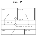
- Fig. 2 illustrates a situation where there is a need to perform the space map matching in accordance with an embodiment of the present invention. Referring to Fig.
- the concept of a space is a method to match positioning data to be within a specific area of an indoor space and is efficient to determine whether which space a user or a user terminal is really located in.
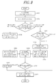
- Fig. 3 is a flowchart illustrating a method of performing a map matching in a user terminal, in accordance with an embodiment of the present invention.
- a process of performing a map matching in a user terminal will be described as follows.
- a user terminal receives positioning data. That is, the user terminal measures a position of the user terminal using a positioning device.
- the user terminal may receive information about its position via a separate positioning device outside the user terminal or an external server having a positioning functionality.
- the user terminal may measure its own position by way of communicating with an NFC (Near Field Communication) module or through the use of a QR (Quick Response) code.
- the user terminal may also measure its own position by way of utilizing various technologies such as a WiFi, Zigbee, Bluetooth and the like.
- the user terminal determines whether which space the position of the user terminal is located in. That is, the user terminal performs the space map matching on the position of the user terminal based on the positioning data and determines a space where the user terminal is located and spaces to which the user terminal may be movable in the future. Such a process carried out in block S302 will be described with reference to Fig. 4 later.
- the user terminal determines whether a network map matching has ever performed or not based on the positioning data. If the network map matching has not yet been made, the method advances to block S306 to perform an initial map matching based on the positioning data. However, if the network map matching has already been made, the method goes to block S310 to perform an estimation map matching based on the positioning data and a map matching result that has been made previously. The details for the initial map matching and the estimation map matching will be mentioned later.
- the initial map matching may be made in sequence as follows:
- the user terminal searches one or more candidate links. That is, the user terminal searches one or more candidate links that will be subjected to the map matching.
- a distance criterion is established to search the candidate links around the positioning data. While the embodiment describes to search the candidate links within a range of 10 m (on a distance basis) based on the positioning data, it is not limited thereto.
- the distance criterion may differ with a setting from a user or a variety of conditions.
- the user terminal carries out a suitability decision with respect to the candidate links. That is, the user terminal determines whether the candidate links are suitable and then selects a candidate link which has the highest suitability.
- a suitability decision is made with respect to the respective candidate links. That is, distance suitability and space suitability are calculated with respect to each of the candidate links, a total score of the respective calculated suitability is compared with a reference score to determine whether each of the candidate links is to be registered or abolished.
- a final link is selected as a link having a largest suitability among the candidate links that has been registered.
- the user terminal determines that this map matching is failed and then retries to perform the initial map matching.
- the preset radius may be about 20m.
- the estimation map matching is a process capable of improving an effectiveness of the map matching by simultaneously reflecting a past map-matching record and positioning data that is currently received.
- the past map-matching record may be reset and then the initial the map matching will be resumed.
- the user terminal performs an initial effectiveness test.
- the initial effectiveness test a previous positioning data is compared to a current positioning data.
- the initial effectiveness test is reset and a process returns to the initial map matching.
- the initial effectiveness test is reset and the initial map matching is recommenced.
- the user terminal searches one or more candidate links. That is, the user terminal searches one or more candidate links that will be subjected to the estimation map matching.
- the user terminal searches a new candidate link based on the candidate links that been searched in the previous map matching. That is, the user terminal searches a new candidate link from the candidate links that been searched in the previous map matching.
- the user terminal remains one or more candidate links whose distance from the current position is below a preset distance remain as a candidate link and registers the candidate links satisfying a condition that a connecting link connected to a previous candidate link is less than or equal to a preset distance from the current position.
- the user terminal performs the suitability decision and yields the map matching result.
- the user terminal carries out a suitability decision with respect to the candidate links. That is the user terminal calculates a score of the suitability for the respective candidate links in accordance with a criterion for the suitability decision and then selects one candidate link which has the highest suitability. That is, the user terminal decides the suitability with respect to the respective candidate links that are newly registered and selects one candidate link that has a highest score of the suitability.
- the user terminal makes a decision of link suitability with respect to the respect candidate links that have been newly searched. More specifically, the user terminal calculates distance suitability, passage suitability, route suitability, connecting suitability, space suitability with respect to the respect candidate links. The user terminal compares a total score of the respective suitability for each candidate link with a preset score of a reference suitability to determine whether to remain or abolish the candidate link. In this connection, the user terminal discards any one of candidate links that are duplicated. The user terminal selects one candidate link as a final candidate link, which has a largest suitability from among the candidate links that remain the registration. It is understood that a ratio by which the space suitability occupies the total suitability score may differ with the presence or absence of the route suitability.
- the user terminal stores the selected candidate link or updates a previously selected candidate link with a newly selected candidate link.
- the user terminal carries out an effectiveness test. That is, the user terminal performs the effectiveness test on the map-matched result. When determining that the map-matched result is not effective, the user terminal initializes this map matching and resumes the initial map matching.
- the user terminal determines that the candidate link is not effective, that is, the candidate link cannot finally pass the effectiveness test.
- the method goes to block S322, and otherwise, when the effectiveness test result invalidity, the method flows to block S320 where a content that has been stored in block S316 is cleared.
- the user terminal outputs a map matching result. That is, the user terminal generates a map matching result in which the position of the user terminal is map-matched to a link or a space, which has the highest suitability.
- Map matching result values may include space information that is determined, map-matched link information, map-matched location, and a projected distance from positioning data to a link when matching on the link.
- the map matching location may include a map-matching location within a space before performing the network map matching and a map matching location on a link after performing the network map matching.
- Fig. 4 is a flowchart explaining in detail a process performed in Block S302 shown in Fig. 3 in accordance with an embodiment of the present invention.
- the process of performing a map matching in the user terminal will be described in detail with reference with Fig. 4 .
- the user terminal receives positioning data. That is, the user terminal measures its own position using a positioning device. For example, the user terminal may measure its own position by way of communicating with an NFC module or through the use of a QR (Quick Response) code. In addition, the user terminal may also measure its own position by way of utilizing various technologies such as a WiFi, Zigbee, Bluetooth and the like.
- a positioning device For example, the user terminal may measure its own position by way of communicating with an NFC module or through the use of a QR (Quick Response) code.
- QR Quick Response
- the user terminal may also measure its own position by way of utilizing various technologies such as a WiFi, Zigbee, Bluetooth and the like.
- the user terminal performs a simple decision/section decision.
- the simple decision will be described as follows.
- the simple decision is to detect a position of the user terminal on a time unit basis with the positioning data, which is input, as a reference.
- Figs. 5A and 5B show respectively an exemplary diagram and a table explaining a simple determination in accordance with an embodiment of the present invention.
- a section decision may be conducted on a basis of the simple determination in accordance with the embodiment of the present invention.
- Fig. 6 is a diagram illustrating a PIP (Point In Polygon) algorithm used to determine which space the user terminal is located in.
- PIP Point In Polygon
- a half line which starts with one point, is created to pass through a polygon. After that, it is determined whether the point is located within the polygon from the number of intersections between the half line and the polygon.
- the section decision is a method to carry out the simple decision on a section basis in order to make up for a matching error which may occur in the simple decision.
- Figs. 7A and 7B are respectively a diagram and a table showing an example making a section decision in the user terminal.
- the section decision ties each specific number of simple decision results in one section to yield the greatest value (or the highest frequency) in each section as a final result.
- a set of three positioning data is grouped into one section, the position of the user terminal will be determined to be stayed in a SPACE 6 at time T4. That is, a space where the user terminal is located at time T4 may maintain the same space where the user terminal has been located at time T3. Of course, the position of the user terminal in the corresponding space may differ actually.
- Both the simple decision and the section decision may consider an accuracy, accumulated direction information, etc. as well as the positioning data.
- the user terminal searches one or more candidate spaces, and if needed, stores the candidate spaces.
- a space where the user terminal is expected to be moved may be a SPACE 2 and a SPACE 1, which have a connectivity with a space where the user terminal is currently located, inclusive of the SPACE 6.
- the user terminal checks whether the space map matching has ever been performed. When it is checked that none space map matching has been made, the user terminal performs the initial map matching based on the positioning data, and otherwise, when it is checked that the space map matching has already been made, the user terminal performs the estimation map matching based on the positioning data and a previous map matching result.
- the user temianl checks a space effectiveness test. If there is an existing result for deriving a candidate space, the user terminal may check whether a currently searched space is an effective space base on the existing result. That is, a candidate space that is searched on a basis of the connectivity of a currently matched space becomes a subject to be checked. Therefore, another space except the candidate space, which is determined as a result of the search, cannot pass through the space effectiveness test.
- the user terminal resets this space map matching when it is determined that the matched space is not effective.
- the user terminal yields a space map matching result.
- Values of the space map matching result may include map-matched space information such as an ID, map-matched coordinates in the map-matched space, and the like.
- the map matching location may include a map-matching location within a space before performing the network map matching and a map matching location on a link after performing the network map matching.
- Fig. 10 is a diagram illustrating an example of searching candidate links
- Fig. 11 is a diagram illustrating the distance suitability in accordance with an embodiment of the present invention.
- the distance suitability considers a distance between the positioning data and the respective candidate links.
- a largest radius for the distance suitability is set within a range of 20m.
- a score of the distance suitability may be calculated in consideration of a ratio deviated from a link with reference to a maximum allowable radius and a largest score of the distance suitability.
- the passage suitability is calculated by comparing passage codes of a link and a traveling direction of the link.
- the route suitability considers whether positioning data presents on a route that is searched if the searched route exist.
- the connecting suitability considers whether a previous matching link has a connecting link.
- Fig. 12 is a diagram expressing the connecting suitability.
- the space suitability considers whether a space is available for moving.
Abstract
Description
- This application claims the benefit of Korean Patent Application No.
10-2013-0068468, filed on June 14, 2013 - The present invention relates to a method for performing a map matching in a user terminal, and more particularly, to a method for performing a map matching to match onto a map a position of a user terminal measured using a positioning device.
- Navigation systems are generally mounted on vehicles and are used as terminal devices for vehicles that help drivers travel and reach his/her destination with ease by displaying a road map for the drivers or searching a route to the destination.
- An automotive navigation system being currently widely used is an apparatus that identifies a current position of a car or a user in real time by calculating signals received from satellites using a Global Positioning System (referred to as 'GPS', hereinafter), converts relevant data in a database, which contains map information and traffic information built previously, corresponding to the current position into image/voice information in association with the database, and displays the converted image/voice.
- The automotive navigation system includes a GPS receiver to calculate a current position of a car. The automotive navigation system obtains information on current speed, time and position of the car through the use of the GPS receiver and provides a user with navigation information based on such information.
- However, when the current position using GPS signals is calculated, there normally occurs an error of tens of meters because of characteristics of the GPS signals. Therefore, when such an error is used to calculate the current position on a map, the current position may be erroneously displayed on a point out of a road, on a rooftop of a building or the like.
- In order to resolve such a drawback, a typical automotive navigation system employs a map matching method when calculating a position of a car. According to the map matching method, a current position is compared to road data under an assumption that the car is driving on a road. When the difference between the current position and the road data falls within a predetermined range, the automotive navigation system determines that the car is driving along the relevant road and forcibly corrects the current position to a point on a road nearest to the current position.
- Korean Laid-Open Patent Publication No.
10-2010-0067578 - Japanese Laid-Open Patent Publication No.
2002-318121 - Generally, when a user terminal such as the automotive navigation system receives a positioning data or measures its current position, a position of a user is displayed by performing a map matching on the positioning data to network data (for example, such as a node or link) nearest to the position of the user. When performing the map matching, however, even in the case that the user is located indoors, especially, at a specific indoor space, the user terminal renders a positioning result to map-match to nearest network data. Accordingly, it is not possible to precisely reflect a real position of the user who is actually located indoors on the map.
- In view of the above, the present invention provides a method to correctly reflect a real position of a user terminal on a map.
- Further, the present invention provides a method to selectively perform a space matching or a network matching depending on a user selection.
- Further, the present invention provides a method to perform a map matching to which a history of a map matching that has been performed already is reflected.
- As set forth above, the embodiment of the present invention performs a map matching on a position of a user terminal that is measured by a position device to display the position on a map, whereby the position of a user terminal can be displayed on the map as compared to a conventional network-based map matching.
- Further, it is possible to remove a temporary error issue caused by a positioning device by accumulating the positions of the user terminal for some period of time and determining a position of the user terminal at a current time using the accumulated positions of the user terminals for displaying it.
- The above and other objects and features of the present invention will become apparent from the following description of embodiments given in conjunction with the accompanying drawings, in which:
-
Fig. 1 is a view explaining a network map matching and a space map matching in accordance with an embodiment of the present invention; -
Fig. 2 illustrates a situation where there is a need to perform a space map matching; -
Fig. 3 is a flowchart schematically illustrating a method of performing a map matching in a user terminal in accordance with an embodiment of the present invention; -
Fig. 4 is a flowchart explaining in detail a process performed in Block S302 shown inFig. 3 in accordance with an embodiment of the present invention; -
Figs. 5A and5B are respectively an exemplary diagram and a table explaining a simple decision in accordance with an embodiment of the present invention; -
Fig. 6 is a diagram illustrating a PIP (Point In Polygon) algorithm used to determine which space a positioning of a user terminal is located in in accordance with an embodiment of the present invention; -
Figs. 7A and7B are respectively an exemplary diagram and a table illustrating an example how to make a section decision in a the user terminal; -
Fig. 8 is a diagram illustrating an example how to search candidate spaces in performing a space map matching; -
Fig. 9 is a diagram illustrating an example how to search candidate links in performing a network map matching; -
Fig. 10 is a diagram illustrating another example how to search candidate links in performing a network map matching; -
Fig. 11 is a diagram illustrating distance suitability; and -
Fig. 12 is a diagram illustrating connection suitability. - The above described and additional aspects of the present invention will be further apparent from the preferred embodiments explained with reference to accompanying drawings. Hereinafter, these embodiments of the present invention will be described in detail so that they can be readily apprehended implemented by those skilled in the art.
- In the entire specification, when a portion "comprises" a constituent, it means that the portion does not exclude another constituent but further comprises other constituent if not described otherwise. Further, terms such as "unit", "apparatus", "module" and "block" mean a unit to process at least one of functions or operations, and they can be embodied by hardware or software or a combination of hardware and software.
- An indoor map matching is a map matching that needs to comprehensively consider a space and a network due to the addition of a concept of a space to an existing network map matching. The term of "space" used herein means specific spatial extent divied by semantic usage such as a store, a dining room, a sensor coverage area, and so on.
- A map matching in associated with the present invention is classified into a space map matching and a network map matching. The space map matching means to match a real position of a user terminal that is measured by a positioning device to a specific space area such as a store, a dining room, a part of corridor, whereas the network map matching means to match a position of a user terminal that is measured by the positioning device to a link or a node. The link or node refers to a point or position at which the position of the user terminal is set as a starting point in order to search a route to a destination, when the user terminal requests the route search. That is, the route search is started from not a real position of the measured user terminal but any one of the links or nodes.
-
Fig. 1 is a view explaining a network map matching and a space map matching in accordance with an embodiment of the present invention. Hereinafter, the network map matching and the space map matching in accordance with an embodiment of the present invention will be described in detail with reference toFig. 1 . Referring toFig. 1 , there is shown a plurality ofspaces including SPACE 1,SPACE 2,SPACE 3, ..., and SPACE 8, and SPACE 9 (which is represented by a corridor inFig. 1 ) adjacent to each space. A space may be one space physically and also one space logically. That is, as shown inFig. 1 , while a set of SPACE1 to SPACE3 may be one space physically, each space may be one of three spaces which are logically divided from one physical space. Similarly, the corridor may be integrally one space or may be separated into desired number of spaces. - Each space includes an entry node intended to enter the space. The
spaces SPACE 1 to SPACE 8 each include an entry node to enter each space. - Additionally, the corridor has a link. The link is a moving route of a user to guide the user along a searched route. For an outdoor environment, the link may be a road on which a vehicle moves, and for an indoor environment, the link may be a corridor through which a user accesses an entry node. Of course, a node may be placed on the link because one link consists of two nodes as illustrated in
Fig. 1 . Referring toFig. 1 , a node may be formed at a crossing point of links and an entry point of each space. - According to a related art, when a position of a user terminal is measured by a positioning device, the position of the user terminal is matched to a link. Whereas, the present invention is proposed to perform a space map matching as well as a network map matching in order to determine a correct position of the user terminal.
- Hereinafter, the network map matching will be described first. As described above, the user terminal performs the network map matching when a route search is requested from the outside.
- As illustrated in
Fig. 1 , a position of a user terminal measured by a positioning device is indicated by a triangle. When a task requested to the user terminal is a route search, the position of the user terminal is matched to an entry node constituting a link or a space. For example, in SPACE1, it can be shown that a position of a user terminal is matched to a link that is formed at an entry node or a link formed in a corridor. In each of SPACE3 and SPACE6, it can also be shown that a position of the user terminal is matched to an entry node within each space. In addition, when a position of the user terminal is at any one point in the corridor, it can be shown that the position of the user terminal is matched to a link formed in the corridor. As such, in accordance with the embodiment, the user terminal performs the network map matching on the position of the user terminal when the requested task is the route search. Hereinafter, the space map matching will be described. - The space map matching means to match a real position of the user terminal, which is measured, within a specific space. In other words, the space map matching refers to a process of matching the just measured position of the user terminal to a position within a particular space that is determined, without moving the measured position to a position on a network. For example, in
Fig. 1 , the position of the user terminal measured by a positioning device is indicated by a triangle, and the position of the user terminal is marked at a real position that is indicated by the triangle.Fig. 2 illustrates a situation where there is a need to perform the space map matching in accordance with an embodiment of the present invention. Referring toFig. 2 , if it does not consider a space concept, even though a user is currently located at aSHOP 1, the position of the user would be map-matched to a link formed in a corridor through a network map matching. Moreover, if the user is located at a space where theSHOP 1 and a corridor are separated by a wall, the user may experience an unacceptable map matching result. Therefore, the concept of a space is a method to match positioning data to be within a specific area of an indoor space and is efficient to determine whether which space a user or a user terminal is really located in. -
Fig. 3 is a flowchart illustrating a method of performing a map matching in a user terminal, in accordance with an embodiment of the present invention. Hereinafter, a process of performing a map matching in a user terminal will be described as follows. - In block S300, a user terminal receives positioning data. That is, the user terminal measures a position of the user terminal using a positioning device. Of course, the user terminal may receive information about its position via a separate positioning device outside the user terminal or an external server having a positioning functionality. The user terminal may measure its own position by way of communicating with an NFC (Near Field Communication) module or through the use of a QR (Quick Response) code. In addition, the user terminal may also measure its own position by way of utilizing various technologies such as a WiFi, Zigbee, Bluetooth and the like.
- In block S302, the user terminal determines whether which space the position of the user terminal is located in. That is, the user terminal performs the space map matching on the position of the user terminal based on the positioning data and determines a space where the user terminal is located and spaces to which the user terminal may be movable in the future. Such a process carried out in block S302 will be described with reference to
Fig. 4 later. - In block S304, the user terminal determines whether a network map matching has ever performed or not based on the positioning data. If the network map matching has not yet been made, the method advances to block S306 to perform an initial map matching based on the positioning data. However, if the network map matching has already been made, the method goes to block S310 to perform an estimation map matching based on the positioning data and a map matching result that has been made previously. The details for the initial map matching and the estimation map matching will be mentioned later. The initial map matching may be made in sequence as follows:
- determining a space -> extracting candidate links -> performing suitability decision on the candidate links -> carrying out effectiveness test.
- A procedure of determining a space has already been performed in block S302 and a procedure of extracting candidate links will be explained from block S306 as follows.
- In block S306, the user terminal searches one or more candidate links. That is, the user terminal searches one or more candidate links that will be subjected to the map matching.
- Hereinafter, a process of extracting a first candidate link to be matched will be described with reference to
Fig. 9 . In the initial map matching process, a distance criterion is established to search the candidate links around the positioning data. While the embodiment describes to search the candidate links within a range of 10 m (on a distance basis) based on the positioning data, it is not limited thereto. For example, the distance criterion may differ with a setting from a user or a variety of conditions. - The suitability decision and the final link extraction will be processed as follows.
- In block S308, the user terminal carries out a suitability decision with respect to the candidate links. That is, the user terminal determines whether the candidate links are suitable and then selects a candidate link which has the highest suitability.
- First, a suitability decision is made with respect to the respective candidate links. That is, distance suitability and space suitability are calculated with respect to each of the candidate links, a total score of the respective calculated suitability is compared with a reference score to determine whether each of the candidate links is to be registered or abolished. A final link is selected as a link having a largest suitability among the candidate links that has been registered.
- During the suitability decision, when there is no link within a preset radius defined on the basis of the positioning data, the user terminal determines that this map matching is failed and then retries to perform the initial map matching. As an example, the preset radius may be about 20m.
- Next, the sequence of the estimation map matching is as follows:
- determining a space -> performing an initial effectiveness test -> extracting candidate links -> performing suitability decision on the candidate links to yield a map matching result -> performing an effectiveness test.
- The estimation map matching is a process capable of improving an effectiveness of the map matching by simultaneously reflecting a past map-matching record and positioning data that is currently received. However, when the positioning data that is received and the past map matching result are not effective in the course of the estimation map matching, the past map-matching record may be reset and then the initial the map matching will be resumed.
- In block S310, the user terminal performs an initial effectiveness test. In the initial effectiveness test, a previous positioning data is compared to a current positioning data. When an amount of change in positions of the current positioning data relative to the previous positioning data is above a preset range, the initial effectiveness test is reset and a process returns to the initial map matching. As an example, when an amount of change in positions is more than or equal to 20m, the initial effectiveness test is reset and the initial map matching is recommenced.
- In block S312, the user terminal searches one or more candidate links. That is, the user terminal searches one or more candidate links that will be subjected to the estimation map matching. The user terminal searches a new candidate link based on the candidate links that been searched in the previous map matching. That is, the user terminal searches a new candidate link from the candidate links that been searched in the previous map matching. Among the previous candidate links, the user terminal remains one or more candidate links whose distance from the current position is below a preset distance remain as a candidate link and registers the candidate links satisfying a condition that a connecting link connected to a previous candidate link is less than or equal to a preset distance from the current position.
- Thereafter, the user terminal performs the suitability decision and yields the map matching result.
- In block S314, the user terminal carries out a suitability decision with respect to the candidate links. That is the user terminal calculates a score of the suitability for the respective candidate links in accordance with a criterion for the suitability decision and then selects one candidate link which has the highest suitability. That is, the user terminal decides the suitability with respect to the respective candidate links that are newly registered and selects one candidate link that has a highest score of the suitability.
- The user terminal makes a decision of link suitability with respect to the respect candidate links that have been newly searched. More specifically, the user terminal calculates distance suitability, passage suitability, route suitability, connecting suitability, space suitability with respect to the respect candidate links. The user terminal compares a total score of the respective suitability for each candidate link with a preset score of a reference suitability to determine whether to remain or abolish the candidate link. In this connection, the user terminal discards any one of candidate links that are duplicated. The user terminal selects one candidate link as a final candidate link, which has a largest suitability from among the candidate links that remain the registration. It is understood that a ratio by which the space suitability occupies the total suitability score may differ with the presence or absence of the route suitability.
- In block S316, the user terminal stores the selected candidate link or updates a previously selected candidate link with a newly selected candidate link.
- In block S318, the user terminal carries out an effectiveness test. That is, the user terminal performs the effectiveness test on the map-matched result. When determining that the map-matched result is not effective, the user terminal initializes this map matching and resumes the initial map matching. By way of an example, when a candidate link fails to pass the space suitability and has a distance more than 10m away from a previous positioning data and when a candidate link succeeds to pass the space suitability, but has a distance more than 20m away from a previous positioning data, the user terminal determines that the candidate link is not effective, that is, the candidate link cannot finally pass the effectiveness test.
- When the effectiveness test result indicates validity, the method goes to block S322, and otherwise, when the effectiveness test result invalidity, the method flows to block S320 where a content that has been stored in block S316 is cleared.
- In block S322, the user terminal outputs a map matching result. That is, the user terminal generates a map matching result in which the position of the user terminal is map-matched to a link or a space, which has the highest suitability. Map matching result values may include space information that is determined, map-matched link information, map-matched location, and a projected distance from positioning data to a link when matching on the link. Further, the map matching location may include a map-matching location within a space before performing the network map matching and a map matching location on a link after performing the network map matching.
-
Fig. 4 is a flowchart explaining in detail a process performed in Block S302 shown inFig. 3 in accordance with an embodiment of the present invention. Hereinafter, the process of performing a map matching in the user terminal will be described in detail with reference withFig. 4 . - In block S400, the user terminal receives positioning data. That is, the user terminal measures its own position using a positioning device. For example, the user terminal may measure its own position by way of communicating with an NFC module or through the use of a QR (Quick Response) code. In addition, the user terminal may also measure its own position by way of utilizing various technologies such as a WiFi, Zigbee, Bluetooth and the like.
- In block S402, the user terminal performs a simple decision/section decision. First, the simple decision will be described as follows.
- The simple decision is to detect a position of the user terminal on a time unit basis with the positioning data, which is input, as a reference.
Figs. 5A and5B show respectively an exemplary diagram and a table explaining a simple determination in accordance with an embodiment of the present invention. - Referring to
Figs. 5A and5B , considering in respect of the positioning data that is input, it is determined that the user terminal is located in aSPACE 6; however, only at time T4 on the table, it is determined that the user terminal is located at aSPACE 1. Nonetheless, if the user terminal has kept staying in theSPACE 6 actually, the determination made at time T4 may be wrong. Thus, in order to take account such an error, a section decision may be conducted on a basis of the simple determination in accordance with the embodiment of the present invention. -
Fig. 6 is a diagram illustrating a PIP (Point In Polygon) algorithm used to determine which space the user terminal is located in. - In
Fig. 6 , a half line, which starts with one point, is created to pass through a polygon. After that, it is determined whether the point is located within the polygon from the number of intersections between the half line and the polygon. - When the number of intersections is an odd number, it is determined that the point is located within the polygon, and otherwise when the number of intersections is an even number, it is determined that the point is located outside the polygon.
- With the foregoing in mind, referring to
Fig. 6 , for afirst point CASE 1, since the number of intersections is three, which is an odd number; therefore, the point is determined to be within the polygon. For asecond point CASE 2, since the number of intersections is four, which is an even number; therefore, the point is determined to be out of the polygon. - Now, the section decision will be described as follows. The section decision is a method to carry out the simple decision on a section basis in order to make up for a matching error which may occur in the simple decision.
-
Figs. 7A and7B are respectively a diagram and a table showing an example making a section decision in the user terminal. The section decision ties each specific number of simple decision results in one section to yield the greatest value (or the highest frequency) in each section as a final result. Referring toFigs. 7A and7B , for example, when a set of three positioning data is grouped into one section, the position of the user terminal will be determined to be stayed in aSPACE 6 at time T4. That is, a space where the user terminal is located at time T4 may maintain the same space where the user terminal has been located at time T3. Of course, the position of the user terminal in the corresponding space may differ actually. Both the simple decision and the section decision may consider an accuracy, accumulated direction information, etc. as well as the positioning data. - In block S404, the user terminal searches one or more candidate spaces, and if needed, stores the candidate spaces.
- After searching the candidate spaces where it is expected that the user terminal is located through the section decision approach, a space effectiveness test is conducted for each of the candidate spaces.
- As illustrated in
Fig. 8 , when it is determined that the position of the user terminal is located in aSPACE 6 through the use of the section decision, a space where the user terminal is expected to be moved may be aSPACE 2 and aSPACE 1, which have a connectivity with a space where the user terminal is currently located, inclusive of theSPACE 6. - A novel method for deriving one or more candidate spaces is proposed by an embodiment of the present invention and is described as follows:
- 1. Detecting a space where a user is located through the use of simple & section decisions based on positioning data,
- 2. Spawning network data starting from a representative node of the space detected by the
step 1; - 3. Carrying out a PIP (Point in Polygon) test of an end node of the link that is spawned (on a basis of a spawning direction);
- 4. Searching a space including the end node of the link that is spawned through the PIP test and storing the searched space if the corresponding space is different from the space where the user is located; and stopping the spawning in the direction of the search.
- 5. Carrying out the
step 4 on a connecting link direction basis. But, if an attribute of the end node of the link considering the spawning direction has "a door node", the spawning is performed to search for a next connecting link without passing through the PIP test. - In block S406, the user terminal checks whether the space map matching has ever been performed. When it is checked that none space map matching has been made, the user terminal performs the initial map matching based on the positioning data, and otherwise, when it is checked that the space map matching has already been made, the user terminal performs the estimation map matching based on the positioning data and a previous map matching result.
- In block S408, the user temianl checks a space effectiveness test. If there is an existing result for deriving a candidate space, the user terminal may check whether a currently searched space is an effective space base on the existing result. That is, a candidate space that is searched on a basis of the connectivity of a currently matched space becomes a subject to be checked. Therefore, another space except the candidate space, which is determined as a result of the search, cannot pass through the space effectiveness test.
- In block S414, the user terminal resets this space map matching when it is determined that the matched space is not effective.
- In block S416, the user terminal yields a space map matching result. Values of the space map matching result may include map-matched space information such as an ID, map-matched coordinates in the map-matched space, and the like. Further, the map matching location may include a map-matching location within a space before performing the network map matching and a map matching location on a link after performing the network map matching.
- Hereinafter, individual suitability will be described separately in detail.
-
Fig. 10 is a diagram illustrating an example of searching candidate links; andFig. 11 is a diagram illustrating the distance suitability in accordance with an embodiment of the present invention. - The distance suitability considers a distance between the positioning data and the respective candidate links. By way of example, a largest radius for the distance suitability is set within a range of 20m. A score of the distance suitability may be calculated in consideration of a ratio deviated from a link with reference to a maximum allowable radius and a largest score of the distance suitability.
- The passage suitability is calculated by comparing passage codes of a link and a traveling direction of the link.
- The route suitability considers whether positioning data presents on a route that is searched if the searched route exist.
- The connecting suitability considers whether a previous matching link has a connecting link.
Fig. 12 is a diagram expressing the connecting suitability. - The space suitability considers whether a space is available for moving.
- While the present invention has been shown and described with respect to the preferred embodiments, the present invention is not necessarily limited thereto. It will be easily appreciated by those skilled in the art that various substitutions, changes and modifications may be made within a scope without departing from the technical idea of the invention.
Claims (10)
- A method for performing a map matching in a user terminal, the method comprising:determining a space where the user terminal is located using positioning data that is measured at predetermined time intervals;searching one or more links that are located within a range of a preset distance from the space as a candidate link;selecting one of the candidate links which best meets at least one suitability criterion of at least two suitability criteria including distance suitability and space suitability; andcarrying out the map matching with respect to the selected one candidate link.
- The method of claim 1, wherein said determining a space where the user terminal is located comprises:determining whether the user terminal moves to another space from the space, which is measured at the predetermined time intervals, where the user terminal is located;determining whether the user terminal moves from another space where the user terminal is located to the space where the user terminal has been located previously within the predetermined time intervals; andwhen it is determined that the user terminal moves, accumulating at least three positioning data measured at predetermined time interval to determine whether which space the user terminal is located in.
- The method of claim 1, wherein said determining a space where the user terminal is located comprises:accumulating at least three positioning data measured at predetermined time interval to determine whether which space the user terminal is located in.
- The method of claim 2, further comprising:determining whether there is a record which has determined a space where the user terminal is located; andwhen it is determined that there is the record, determining whether the space that is determined that the user terminal is located has a connectivity with the space where the user terminal has been located previously.
- The method of claim 1, wherein said selecting one of the candidate links comprises:determining whether a distance between a position of the user terminal, which is determined from a previously measured positioning data, and a position of the user terminal, which is determined from a currently measured positioning data, falls within a range of a preset distance; andwhen the distance falls within the range of the preset distance, selecting either the candidate links which are derived through the use of the previously measured positioning data or connecting links of the candidate links as the candidate link, wherein the selected candidate links or the selected connecting links meet a preset condition.
- The method of claim 5, wherein the selected candidate links or the selected connecting links meet a preset condition comprises:the candidate links which are located within a range of preset distance from a position that is determined from currently measured positioning data or connecting links of the candidate links.
- The method of claim 1, wherein the suitability criterion comprises at least one of:distance suitability to determine a distance from the position of the user terminal to a candidate link;a space suitability to determine whether the position of the user terminal is movable to a candidate link;a route suitability to determine whether the position of the user terminal, which is measured using the positioning data, is located on a route;a passage suitability to define passage codes of a link and a traveling direction of the link; anda connection suitability to determine whether a previous candidate link has a candidate link.
- The method of claim 1, further comprising:after said performing a map matching, displaying a map matching result,wherein the map matching result comprises information about the space that has been determined and information about the link that has been matched.
- The method of claim 8, wherein the map matching result comprises at least one of:a matching location within the space that has been determined;a location of the matched link; anda distance between the matched location within the space and a location of the matched link.
- A method for performing a map matching in a user terminal, the method comprising:performing a space map matching to determine a space where the user terminal is located using positioning data that is measured at predetermined time intervals; andperforming a network map matching to match a position of the user terminal to network data using positioning data that is measured after performing the space map matching.
Applications Claiming Priority (1)
| Application Number | Priority Date | Filing Date | Title |
|---|---|---|---|
| KR1020130068468A KR101493817B1 (en) | 2013-06-14 | 2013-06-14 | Method for map matching of user terminal |
Publications (2)
| Publication Number | Publication Date |
|---|---|
| EP2813816A1 true EP2813816A1 (en) | 2014-12-17 |
| EP2813816B1 EP2813816B1 (en) | 2019-05-01 |
Family
ID=49448017
Family Applications (1)
| Application Number | Title | Priority Date | Filing Date |
|---|---|---|---|
| EP13189710.0A Active EP2813816B1 (en) | 2013-06-14 | 2013-10-22 | Method for performing map matching in user terminal |
Country Status (5)
| Country | Link |
|---|---|
| US (1) | US9002639B2 (en) |
| EP (1) | EP2813816B1 (en) |
| JP (1) | JP6336738B2 (en) |
| KR (1) | KR101493817B1 (en) |
| CN (1) | CN104236564B (en) |
Cited By (1)
| Publication number | Priority date | Publication date | Assignee | Title |
|---|---|---|---|---|
| CN106855878A (en) * | 2016-11-17 | 2017-06-16 | 北京京东尚科信息技术有限公司 | History wheelpath display methods and device based on electronic map |
Families Citing this family (17)
| Publication number | Priority date | Publication date | Assignee | Title |
|---|---|---|---|---|
| US9241353B2 (en) * | 2013-07-26 | 2016-01-19 | Qualcomm Incorporated | Communications between a mobile device and an access point device |
| US9488490B2 (en) * | 2014-04-02 | 2016-11-08 | Here Global B.V. | Storing and accessing traffic data images in a limited bandwidth environment |
| JP6413404B2 (en) * | 2014-07-07 | 2018-10-31 | カシオ計算機株式会社 | Electronic device, position estimation method and program |
| US20170307393A1 (en) * | 2014-12-17 | 2017-10-26 | Sony Corporation | Information processing apparatus, information processing method, and program |
| CN105868826A (en) * | 2015-01-23 | 2016-08-17 | 中兴通讯股份有限公司 | Method and device for determination of position relation |
| US9836874B2 (en) * | 2015-01-27 | 2017-12-05 | Splunk Inc. | Efficient polygon-clipping technique to reduce data transfer requirements for a viewport |
| US9916326B2 (en) | 2015-01-27 | 2018-03-13 | Splunk, Inc. | Efficient point-in-polygon indexing technique for facilitating geofencing operations |
| US10026204B2 (en) | 2015-01-27 | 2018-07-17 | Splunk Inc. | Efficient point-in-polygon indexing technique for processing queries over geographic data sets |
| US9607414B2 (en) | 2015-01-27 | 2017-03-28 | Splunk Inc. | Three-dimensional point-in-polygon operation to facilitate displaying three-dimensional structures |
| DE102016204823A1 (en) * | 2016-03-23 | 2017-09-28 | Ford Global Technologies, Llc | GPS-based area recognition in vehicles |
| US10145691B2 (en) * | 2016-05-18 | 2018-12-04 | Here Global B.V. | Ambiguity map match rating |
| CN107580337B (en) * | 2016-07-05 | 2022-05-13 | 中兴通讯股份有限公司 | Hot spot area identification method and device |
| GB201613105D0 (en) | 2016-07-29 | 2016-09-14 | Tomtom Navigation Bv | Methods and systems for map matching |
| JP6982954B2 (en) * | 2016-09-30 | 2021-12-17 | コイト電工株式会社 | Map matching processing device, map matching processing program and transportation related system |
| KR102360466B1 (en) * | 2017-09-30 | 2022-02-08 | 현대오토에버 주식회사 | Map matching method using reverse tracking map matching |
| JP7115246B2 (en) * | 2018-11-21 | 2022-08-09 | 日本電信電話株式会社 | Current position estimation device, current position estimation method, and program |
| CN109708647A (en) * | 2019-03-08 | 2019-05-03 | 哈尔滨工程大学 | A kind of indoor topological map pedestrian localization method based on fusion feature element |
Citations (4)
| Publication number | Priority date | Publication date | Assignee | Title |
|---|---|---|---|---|
| WO2001061271A2 (en) * | 2000-02-15 | 2001-08-23 | Prolink, Inc. | Map-matching golf navigation system |
| JP2002318121A (en) | 2001-04-23 | 2002-10-31 | Pioneer Electronic Corp | Navigation apparatus |
| KR20100006757A (en) | 2008-07-10 | 2010-01-21 | 주식회사 로택스인 | The business agreement system and method between the tax agent and the legal agent |
| US20130151140A1 (en) * | 2011-12-12 | 2013-06-13 | Hyundai Mnsoft, Inc. | Apparatus and method for performing map matching |
Family Cites Families (12)
| Publication number | Priority date | Publication date | Assignee | Title |
|---|---|---|---|---|
| US6024655A (en) * | 1997-03-31 | 2000-02-15 | Leading Edge Technologies, Inc. | Map-matching golf navigation system |
| DE10006750A1 (en) * | 2000-02-15 | 2001-08-16 | Patent Treuhand Ges Fuer Elektrische Gluehlampen Mbh | Manufacturing process for a flat gas discharge lamp |
| KR100620238B1 (en) * | 2003-06-18 | 2006-09-13 | 팅크웨어(주) | Method For Supplying Map Data Using A Mobile Communication Device And System For Enabling The Method |
| JP4571887B2 (en) * | 2005-05-31 | 2010-10-27 | 株式会社ナビタイムジャパン | Navigation system, matching method, route search server, and navigation terminal device |
| JP4418828B2 (en) * | 2007-06-29 | 2010-02-24 | 株式会社三菱総合研究所 | Map matching device, map matching method and program thereof |
| SG183690A1 (en) * | 2007-08-06 | 2012-09-27 | Trx Systems Inc | Locating, tracking, and/or monitoring personnel and/or assets both indoors and outdoors |
| KR20090070936A (en) * | 2007-12-27 | 2009-07-01 | 에스케이마케팅앤컴퍼니 주식회사 | System and method for navigation, storage medium recording that metho program |
| KR101210597B1 (en) | 2008-12-11 | 2012-12-11 | 한국전자통신연구원 | Method and Apparatus for Map Matching of Moving Objects |
| US8150620B2 (en) * | 2009-04-14 | 2012-04-03 | Alpine Electronics, Inc. | Route search method and apparatus for navigation system utilizing map data of XML format |
| CN102435197B (en) * | 2011-08-05 | 2014-10-15 | 刘建勋 | MBR (Master Boot Record)-based GPS (Global Position System) track map matching method |
| US9311417B2 (en) * | 2012-03-09 | 2016-04-12 | Oracle International Corporation | Personalized navigation shortcuts |
| CN103037507A (en) * | 2012-12-17 | 2013-04-10 | 浙江鸿程计算机系统有限公司 | Map matching method based on Cell-identification (ID) location technology |
-
2013
- 2013-06-14 KR KR1020130068468A patent/KR101493817B1/en active IP Right Grant
- 2013-10-22 EP EP13189710.0A patent/EP2813816B1/en active Active
- 2013-10-30 US US14/066,790 patent/US9002639B2/en active Active
- 2013-10-30 CN CN201310528605.3A patent/CN104236564B/en active Active
- 2013-11-15 JP JP2013237468A patent/JP6336738B2/en active Active
Patent Citations (4)
| Publication number | Priority date | Publication date | Assignee | Title |
|---|---|---|---|---|
| WO2001061271A2 (en) * | 2000-02-15 | 2001-08-23 | Prolink, Inc. | Map-matching golf navigation system |
| JP2002318121A (en) | 2001-04-23 | 2002-10-31 | Pioneer Electronic Corp | Navigation apparatus |
| KR20100006757A (en) | 2008-07-10 | 2010-01-21 | 주식회사 로택스인 | The business agreement system and method between the tax agent and the legal agent |
| US20130151140A1 (en) * | 2011-12-12 | 2013-06-13 | Hyundai Mnsoft, Inc. | Apparatus and method for performing map matching |
Cited By (2)
| Publication number | Priority date | Publication date | Assignee | Title |
|---|---|---|---|---|
| CN106855878A (en) * | 2016-11-17 | 2017-06-16 | 北京京东尚科信息技术有限公司 | History wheelpath display methods and device based on electronic map |
| CN106855878B (en) * | 2016-11-17 | 2020-03-03 | 北京京东尚科信息技术有限公司 | Historical driving track display method and device based on electronic map |
Also Published As
| Publication number | Publication date |
|---|---|
| JP6336738B2 (en) | 2018-06-06 |
| JP2015001520A (en) | 2015-01-05 |
| CN104236564A (en) | 2014-12-24 |
| CN104236564B (en) | 2017-04-12 |
| US20140372024A1 (en) | 2014-12-18 |
| US9002639B2 (en) | 2015-04-07 |
| KR101493817B1 (en) | 2015-03-02 |
| KR20140145824A (en) | 2014-12-24 |
| EP2813816B1 (en) | 2019-05-01 |
Similar Documents
| Publication | Publication Date | Title |
|---|---|---|
| EP2813816B1 (en) | Method for performing map matching in user terminal | |
| US8903647B2 (en) | Apparatus and method for performing map matching | |
| KR102297478B1 (en) | Trajectory matching using ambient signals | |
| JP4728095B2 (en) | Navigation device | |
| EP2442072B1 (en) | Route search device and route search method | |
| KR102022668B1 (en) | Landmark positioning | |
| US20090198443A1 (en) | In-vehicle navigation device and parking space guiding method | |
| KR20160013713A (en) | Global path generation apparatus for autonomous vehicle and method thereof | |
| CN104869634A (en) | Method and device for correcting positioning result | |
| US8515665B2 (en) | On-board vehicle navigation device and program | |
| JP2015090285A (en) | Vehicle position identification system and vehicle position identification method | |
| KR20190038739A (en) | Method for detecting the changing point of road | |
| JP5162704B2 (en) | Apparatus and method for assigning current measurements of geographic location to map objects | |
| KR100967931B1 (en) | Address searching navigation system and address searching method | |
| EP2520902A1 (en) | Determining a position of a navigation device | |
| JP2010203797A (en) | Navigation device, navigation method and program | |
| WO2012069909A2 (en) | Information providing system and information providing method | |
| JP2007322304A (en) | Navigation device, and navigation method | |
| JP4646720B2 (en) | Navigation device | |
| JP4369900B2 (en) | Matching network data, matching network data creation method, navigation system having matching network data, route search server, and navigation terminal device | |
| KR20120134435A (en) | Method of deciding going in and out building of vehicle using altitude information in navigation system and apparatus therof | |
| KR102231636B1 (en) | Method for estimating moving direction, apparatus and server | |
| JP6264020B2 (en) | Driving assistance device | |
| JP2015148703A (en) | map creating apparatus | |
| JP6201451B2 (en) | Terminal device, route guidance method and program |
Legal Events
| Date | Code | Title | Description |
|---|---|---|---|
| 17P | Request for examination filed |
Effective date: 20131022 |
|
| AK | Designated contracting states |
Kind code of ref document: A1 Designated state(s): AL AT BE BG CH CY CZ DE DK EE ES FI FR GB GR HR HU IE IS IT LI LT LU LV MC MK MT NL NO PL PT RO RS SE SI SK SM TR |
|
| AX | Request for extension of the european patent |
Extension state: BA ME |
|
| PUAI | Public reference made under article 153(3) epc to a published international application that has entered the european phase |
Free format text: ORIGINAL CODE: 0009012 |
|
| RBV | Designated contracting states (corrected) |
Designated state(s): AL AT BE BG CH CY CZ DE DK EE ES FI FR GB GR HR HU IE IS IT LI LT LU LV MC MK MT NL NO PL PT RO RS SE SI SK SM TR |
|
| STAA | Information on the status of an ep patent application or granted ep patent |
Free format text: STATUS: EXAMINATION IS IN PROGRESS |
|
| 17Q | First examination report despatched |
Effective date: 20171027 |
|
| REG | Reference to a national code |
Ref country code: DE Ref legal event code: R079 Ref document number: 602013054558 Country of ref document: DE Free format text: PREVIOUS MAIN CLASS: G01C0021200000 Ipc: G01C0021000000 |
|
| GRAP | Despatch of communication of intention to grant a patent |
Free format text: ORIGINAL CODE: EPIDOSNIGR1 |
|
| STAA | Information on the status of an ep patent application or granted ep patent |
Free format text: STATUS: GRANT OF PATENT IS INTENDED |
|
| RIC1 | Information provided on ipc code assigned before grant |
Ipc: G01C 21/00 20060101AFI20181030BHEP |
|
| INTG | Intention to grant announced |
Effective date: 20181127 |
|
| GRAS | Grant fee paid |
Free format text: ORIGINAL CODE: EPIDOSNIGR3 |
|
| GRAA | (expected) grant |
Free format text: ORIGINAL CODE: 0009210 |
|
| STAA | Information on the status of an ep patent application or granted ep patent |
Free format text: STATUS: THE PATENT HAS BEEN GRANTED |
|
| AK | Designated contracting states |
Kind code of ref document: B1 Designated state(s): AL AT BE BG CH CY CZ DE DK EE ES FI FR GB GR HR HU IE IS IT LI LT LU LV MC MK MT NL NO PL PT RO RS SE SI SK SM TR |
|
| REG | Reference to a national code |
Ref country code: GB Ref legal event code: FG4D |
|
| REG | Reference to a national code |
Ref country code: CH Ref legal event code: EP Ref country code: AT Ref legal event code: REF Ref document number: 1127540 Country of ref document: AT Kind code of ref document: T Effective date: 20190515 |
|
| REG | Reference to a national code |
Ref country code: DE Ref legal event code: R096 Ref document number: 602013054558 Country of ref document: DE |
|
| REG | Reference to a national code |
Ref country code: IE Ref legal event code: FG4D |
|
| REG | Reference to a national code |
Ref country code: NL Ref legal event code: MP Effective date: 20190501 |
|
| REG | Reference to a national code |
Ref country code: LT Ref legal event code: MG4D |
|
| PG25 | Lapsed in a contracting state [announced via postgrant information from national office to epo] |
Ref country code: PT Free format text: LAPSE BECAUSE OF FAILURE TO SUBMIT A TRANSLATION OF THE DESCRIPTION OR TO PAY THE FEE WITHIN THE PRESCRIBED TIME-LIMIT Effective date: 20190901 Ref country code: ES Free format text: LAPSE BECAUSE OF FAILURE TO SUBMIT A TRANSLATION OF THE DESCRIPTION OR TO PAY THE FEE WITHIN THE PRESCRIBED TIME-LIMIT Effective date: 20190501 Ref country code: LT Free format text: LAPSE BECAUSE OF FAILURE TO SUBMIT A TRANSLATION OF THE DESCRIPTION OR TO PAY THE FEE WITHIN THE PRESCRIBED TIME-LIMIT Effective date: 20190501 Ref country code: NL Free format text: LAPSE BECAUSE OF FAILURE TO SUBMIT A TRANSLATION OF THE DESCRIPTION OR TO PAY THE FEE WITHIN THE PRESCRIBED TIME-LIMIT Effective date: 20190501 Ref country code: NO Free format text: LAPSE BECAUSE OF FAILURE TO SUBMIT A TRANSLATION OF THE DESCRIPTION OR TO PAY THE FEE WITHIN THE PRESCRIBED TIME-LIMIT Effective date: 20190801 Ref country code: FI Free format text: LAPSE BECAUSE OF FAILURE TO SUBMIT A TRANSLATION OF THE DESCRIPTION OR TO PAY THE FEE WITHIN THE PRESCRIBED TIME-LIMIT Effective date: 20190501 Ref country code: HR Free format text: LAPSE BECAUSE OF FAILURE TO SUBMIT A TRANSLATION OF THE DESCRIPTION OR TO PAY THE FEE WITHIN THE PRESCRIBED TIME-LIMIT Effective date: 20190501 Ref country code: SE Free format text: LAPSE BECAUSE OF FAILURE TO SUBMIT A TRANSLATION OF THE DESCRIPTION OR TO PAY THE FEE WITHIN THE PRESCRIBED TIME-LIMIT Effective date: 20190501 Ref country code: AL Free format text: LAPSE BECAUSE OF FAILURE TO SUBMIT A TRANSLATION OF THE DESCRIPTION OR TO PAY THE FEE WITHIN THE PRESCRIBED TIME-LIMIT Effective date: 20190501 |
|
| PG25 | Lapsed in a contracting state [announced via postgrant information from national office to epo] |
Ref country code: RS Free format text: LAPSE BECAUSE OF FAILURE TO SUBMIT A TRANSLATION OF THE DESCRIPTION OR TO PAY THE FEE WITHIN THE PRESCRIBED TIME-LIMIT Effective date: 20190501 Ref country code: GR Free format text: LAPSE BECAUSE OF FAILURE TO SUBMIT A TRANSLATION OF THE DESCRIPTION OR TO PAY THE FEE WITHIN THE PRESCRIBED TIME-LIMIT Effective date: 20190802 Ref country code: LV Free format text: LAPSE BECAUSE OF FAILURE TO SUBMIT A TRANSLATION OF THE DESCRIPTION OR TO PAY THE FEE WITHIN THE PRESCRIBED TIME-LIMIT Effective date: 20190501 Ref country code: BG Free format text: LAPSE BECAUSE OF FAILURE TO SUBMIT A TRANSLATION OF THE DESCRIPTION OR TO PAY THE FEE WITHIN THE PRESCRIBED TIME-LIMIT Effective date: 20190801 |
|
| REG | Reference to a national code |
Ref country code: AT Ref legal event code: MK05 Ref document number: 1127540 Country of ref document: AT Kind code of ref document: T Effective date: 20190501 |
|
| PG25 | Lapsed in a contracting state [announced via postgrant information from national office to epo] |
Ref country code: IS Free format text: LAPSE BECAUSE OF FAILURE TO SUBMIT A TRANSLATION OF THE DESCRIPTION OR TO PAY THE FEE WITHIN THE PRESCRIBED TIME-LIMIT Effective date: 20190901 |
|
| PG25 | Lapsed in a contracting state [announced via postgrant information from national office to epo] |
Ref country code: CZ Free format text: LAPSE BECAUSE OF FAILURE TO SUBMIT A TRANSLATION OF THE DESCRIPTION OR TO PAY THE FEE WITHIN THE PRESCRIBED TIME-LIMIT Effective date: 20190501 Ref country code: RO Free format text: LAPSE BECAUSE OF FAILURE TO SUBMIT A TRANSLATION OF THE DESCRIPTION OR TO PAY THE FEE WITHIN THE PRESCRIBED TIME-LIMIT Effective date: 20190501 Ref country code: SK Free format text: LAPSE BECAUSE OF FAILURE TO SUBMIT A TRANSLATION OF THE DESCRIPTION OR TO PAY THE FEE WITHIN THE PRESCRIBED TIME-LIMIT Effective date: 20190501 Ref country code: EE Free format text: LAPSE BECAUSE OF FAILURE TO SUBMIT A TRANSLATION OF THE DESCRIPTION OR TO PAY THE FEE WITHIN THE PRESCRIBED TIME-LIMIT Effective date: 20190501 Ref country code: AT Free format text: LAPSE BECAUSE OF FAILURE TO SUBMIT A TRANSLATION OF THE DESCRIPTION OR TO PAY THE FEE WITHIN THE PRESCRIBED TIME-LIMIT Effective date: 20190501 Ref country code: DK Free format text: LAPSE BECAUSE OF FAILURE TO SUBMIT A TRANSLATION OF THE DESCRIPTION OR TO PAY THE FEE WITHIN THE PRESCRIBED TIME-LIMIT Effective date: 20190501 |
|
| REG | Reference to a national code |
Ref country code: DE Ref legal event code: R097 Ref document number: 602013054558 Country of ref document: DE |
|
| PG25 | Lapsed in a contracting state [announced via postgrant information from national office to epo] |
Ref country code: IT Free format text: LAPSE BECAUSE OF FAILURE TO SUBMIT A TRANSLATION OF THE DESCRIPTION OR TO PAY THE FEE WITHIN THE PRESCRIBED TIME-LIMIT Effective date: 20190501 Ref country code: SM Free format text: LAPSE BECAUSE OF FAILURE TO SUBMIT A TRANSLATION OF THE DESCRIPTION OR TO PAY THE FEE WITHIN THE PRESCRIBED TIME-LIMIT Effective date: 20190501 |
|
| PLBE | No opposition filed within time limit |
Free format text: ORIGINAL CODE: 0009261 |
|
| STAA | Information on the status of an ep patent application or granted ep patent |
Free format text: STATUS: NO OPPOSITION FILED WITHIN TIME LIMIT |
|
| PG25 | Lapsed in a contracting state [announced via postgrant information from national office to epo] |
Ref country code: TR Free format text: LAPSE BECAUSE OF FAILURE TO SUBMIT A TRANSLATION OF THE DESCRIPTION OR TO PAY THE FEE WITHIN THE PRESCRIBED TIME-LIMIT Effective date: 20190501 |
|
| 26N | No opposition filed |
Effective date: 20200204 |
|
| PG25 | Lapsed in a contracting state [announced via postgrant information from national office to epo] |
Ref country code: PL Free format text: LAPSE BECAUSE OF FAILURE TO SUBMIT A TRANSLATION OF THE DESCRIPTION OR TO PAY THE FEE WITHIN THE PRESCRIBED TIME-LIMIT Effective date: 20190501 |
|
| PG25 | Lapsed in a contracting state [announced via postgrant information from national office to epo] |
Ref country code: MC Free format text: LAPSE BECAUSE OF FAILURE TO SUBMIT A TRANSLATION OF THE DESCRIPTION OR TO PAY THE FEE WITHIN THE PRESCRIBED TIME-LIMIT Effective date: 20190501 Ref country code: SI Free format text: LAPSE BECAUSE OF FAILURE TO SUBMIT A TRANSLATION OF THE DESCRIPTION OR TO PAY THE FEE WITHIN THE PRESCRIBED TIME-LIMIT Effective date: 20190501 |
|
| REG | Reference to a national code |
Ref country code: CH Ref legal event code: PL |
|
| PG25 | Lapsed in a contracting state [announced via postgrant information from national office to epo] |
Ref country code: CH Free format text: LAPSE BECAUSE OF NON-PAYMENT OF DUE FEES Effective date: 20191031 Ref country code: LI Free format text: LAPSE BECAUSE OF NON-PAYMENT OF DUE FEES Effective date: 20191031 Ref country code: LU Free format text: LAPSE BECAUSE OF NON-PAYMENT OF DUE FEES Effective date: 20191022 |
|
| REG | Reference to a national code |
Ref country code: BE Ref legal event code: MM Effective date: 20191031 |
|
| PG25 | Lapsed in a contracting state [announced via postgrant information from national office to epo] |
Ref country code: BE Free format text: LAPSE BECAUSE OF NON-PAYMENT OF DUE FEES Effective date: 20191031 |
|
| PG25 | Lapsed in a contracting state [announced via postgrant information from national office to epo] |
Ref country code: IE Free format text: LAPSE BECAUSE OF NON-PAYMENT OF DUE FEES Effective date: 20191022 |
|
| PG25 | Lapsed in a contracting state [announced via postgrant information from national office to epo] |
Ref country code: CY Free format text: LAPSE BECAUSE OF FAILURE TO SUBMIT A TRANSLATION OF THE DESCRIPTION OR TO PAY THE FEE WITHIN THE PRESCRIBED TIME-LIMIT Effective date: 20190501 |
|
| PG25 | Lapsed in a contracting state [announced via postgrant information from national office to epo] |
Ref country code: MT Free format text: LAPSE BECAUSE OF FAILURE TO SUBMIT A TRANSLATION OF THE DESCRIPTION OR TO PAY THE FEE WITHIN THE PRESCRIBED TIME-LIMIT Effective date: 20190501 Ref country code: HU Free format text: LAPSE BECAUSE OF FAILURE TO SUBMIT A TRANSLATION OF THE DESCRIPTION OR TO PAY THE FEE WITHIN THE PRESCRIBED TIME-LIMIT; INVALID AB INITIO Effective date: 20131022 |
|
| REG | Reference to a national code |
Ref country code: DE Ref legal event code: R081 Ref document number: 602013054558 Country of ref document: DE Owner name: HYUNDAI AUTOEVER CORP., KR Free format text: FORMER OWNER: HYUNDAI MNSOFT, INC., SEOUL, KR |
|
| REG | Reference to a national code |
Ref country code: GB Ref legal event code: 732E Free format text: REGISTERED BETWEEN 20211104 AND 20211110 |
|
| PG25 | Lapsed in a contracting state [announced via postgrant information from national office to epo] |
Ref country code: MK Free format text: LAPSE BECAUSE OF FAILURE TO SUBMIT A TRANSLATION OF THE DESCRIPTION OR TO PAY THE FEE WITHIN THE PRESCRIBED TIME-LIMIT Effective date: 20190501 |
|
| P01 | Opt-out of the competence of the unified patent court (upc) registered |
Effective date: 20230704 |
|
| PGFP | Annual fee paid to national office [announced via postgrant information from national office to epo] |
Ref country code: GB Payment date: 20230807 Year of fee payment: 11 |
|
| PGFP | Annual fee paid to national office [announced via postgrant information from national office to epo] |
Ref country code: FR Payment date: 20230725 Year of fee payment: 11 |
|
| PGFP | Annual fee paid to national office [announced via postgrant information from national office to epo] |
Ref country code: DE Payment date: 20230720 Year of fee payment: 11 |