EP2578033B1 - Hybrid mobile phone geopositioning - Google Patents
Hybrid mobile phone geopositioning Download PDFInfo
- Publication number
- EP2578033B1 EP2578033B1 EP11790195.9A EP11790195A EP2578033B1 EP 2578033 B1 EP2578033 B1 EP 2578033B1 EP 11790195 A EP11790195 A EP 11790195A EP 2578033 B1 EP2578033 B1 EP 2578033B1
- Authority
- EP
- European Patent Office
- Prior art keywords
- location
- mobile device
- mobile
- map
- data
- Prior art date
- Legal status (The legal status is an assumption and is not a legal conclusion. Google has not performed a legal analysis and makes no representation as to the accuracy of the status listed.)
- Active
Links
Images


Classifications
-
- H—ELECTRICITY
- H04—ELECTRIC COMMUNICATION TECHNIQUE
- H04W—WIRELESS COMMUNICATION NETWORKS
- H04W64/00—Locating users or terminals or network equipment for network management purposes, e.g. mobility management
-
- G—PHYSICS
- G01—MEASURING; TESTING
- G01S—RADIO DIRECTION-FINDING; RADIO NAVIGATION; DETERMINING DISTANCE OR VELOCITY BY USE OF RADIO WAVES; LOCATING OR PRESENCE-DETECTING BY USE OF THE REFLECTION OR RERADIATION OF RADIO WAVES; ANALOGOUS ARRANGEMENTS USING OTHER WAVES
- G01S5/00—Position-fixing by co-ordinating two or more direction or position line determinations; Position-fixing by co-ordinating two or more distance determinations
- G01S5/02—Position-fixing by co-ordinating two or more direction or position line determinations; Position-fixing by co-ordinating two or more distance determinations using radio waves
- G01S5/0252—Radio frequency fingerprinting
- G01S5/02521—Radio frequency fingerprinting using a radio-map
- G01S5/02524—Creating or updating the radio-map
-
- H—ELECTRICITY
- H04—ELECTRIC COMMUNICATION TECHNIQUE
- H04W—WIRELESS COMMUNICATION NETWORKS
- H04W4/00—Services specially adapted for wireless communication networks; Facilities therefor
- H04W4/02—Services making use of location information
- H04W4/023—Services making use of location information using mutual or relative location information between multiple location based services [LBS] targets or of distance thresholds
-
- H—ELECTRICITY
- H04—ELECTRIC COMMUNICATION TECHNIQUE
- H04W—WIRELESS COMMUNICATION NETWORKS
- H04W4/00—Services specially adapted for wireless communication networks; Facilities therefor
- H04W4/02—Services making use of location information
- H04W4/025—Services making use of location information using location based information parameters
-
- H—ELECTRICITY
- H04—ELECTRIC COMMUNICATION TECHNIQUE
- H04W—WIRELESS COMMUNICATION NETWORKS
- H04W4/00—Services specially adapted for wireless communication networks; Facilities therefor
- H04W4/02—Services making use of location information
- H04W4/029—Location-based management or tracking services
-
- H—ELECTRICITY
- H04—ELECTRIC COMMUNICATION TECHNIQUE
- H04W—WIRELESS COMMUNICATION NETWORKS
- H04W88/00—Devices specially adapted for wireless communication networks, e.g. terminals, base stations or access point devices
- H04W88/18—Service support devices; Network management devices
Landscapes
- Engineering & Computer Science (AREA)
- Computer Networks & Wireless Communication (AREA)
- Signal Processing (AREA)
- Physics & Mathematics (AREA)
- General Physics & Mathematics (AREA)
- Radar, Positioning & Navigation (AREA)
- Remote Sensing (AREA)
- Mobile Radio Communication Systems (AREA)
- Position Fixing By Use Of Radio Waves (AREA)
- Telephone Function (AREA)
- Telephonic Communication Services (AREA)
Description
- The recovery of the location of a mobile device, such as a cellular telephone or a smart phone, is the basis for a wide range of Location-Based-Services (LBS). A Location Based Service is an information service, accessible to mobile devices through the cellular network utilizing the geographical position of the mobile device. Location based services can be used in a variety of contexts, such as health, work, personal, and entertainment by identifying the location of an individual or object using the position of the mobile device and providing the individual with information regarding various service providers in the same location as the individual. LBS can include sending advertising directed at customers based on their location, personalized weather services, locations of restaurants, gas stations, other businesses, and comparable services.
- Various techniques may be utilized in order to determine the location of a mobile device, including network based cell tower triangulation, Global Positioning System (GPS), peer-based systems (e.g. Bluetooth based short range systems), and Wireless Local Area Networks (WLAN). Network-based techniques, such as cellular triangulation, utilize the service provider's network infrastructure and temporal delay of tower signals from nearby cell towers' receptions to identify the location of a mobile device within a "cell." This method is the most common as it can be implemented cost effectively and non-intrusively while the mobile device is not actively in use by the user. However, the accuracy of this technique is relatively low due to its dependence on the concentration of base station cells, achieving an accuracy of a few tenths of meters in urban areas, but as poor as hundreds of meters in suburban areas and rural zones. Accuracy may also vary due to obstacles such as large buildings and weather conditions.
- Using WLANs may apply a similar triangulation method with the WLAN signal origination spot as the basis for the triangulation cell, or more commonly the location can be estimated by sensing a single WLAN source, as the WLAN range is typically limited. This method may be more useful in urban areas, where the relatively large number of WLAN spots may generate smaller cells relative to cell towers and increase positional accuracies. However, WLAN spots must be mapped relative to the world, and their use is dependent on a comprehensive database of WLAN access points. WLAN points maybe very dynamic, and may be added, removed, turned on and off quite frequently. Their accuracy may also be reduced due to obstacles and weather. Another approach using GPS is the most accurate method of locating a mobile device to within 10-30 meters. However, this approach requires substantial computation power and is energy expensive, which may rapidly deplete battery power on a mobile device. As a result, GPS based location determination is commonly used for short intervals or in specific navigation tasks, and is not continuously activated on most mobile devices. GPS is also difficult to be sensed in indoor environments.
-
US 2008/0268870 A1 describes a technique for providing the location of a first mobile device to a second device. The second device generates a query for the location of the first device which is directed to the first device. Upon receipt of the query, the first device initiates a determination of its location, e.g. by providing information to a central server, and the determined location of the first device is then directed to the second device, either directly from the central server or via the first device. -
US 2010/0093368 A1 describes a technique for localizing terminal devices, including managing reference ambient information of surroundings of a terminal device. Update information of the surroundings of the terminal device is received. A reliability of the update information is assessed. The reference ambient information of the surroundings of the terminal device is changed when a reliability criterion is fulfilled when assessing the reliability. - This summary is provided to introduce a selection of concepts in a simplified form that are further described below in the Detailed Description. This summary is not intended to exclusively identify key features or essential features of the claimed subject matter.
- Embodiments are directed to a hybrid positioning system for continuously and accurately determining a location of a mobile device. The hybrid positioning system may utilize samples of GPS locations from a pool of mobile devices accompanied by cell tower data, WLAN data, or other comparable network signals to construct a dynamic map of particular regions. According to some embodiments, the dynamic map may be sent to and stored on a mobile device. The map may enable the mobile device to compare its less accurate, but more readily available, data such as cell tower signals to recorded ones and estimate its position more accurately. The position data may be further enhanced by GPS data whenever it is available. The mobile device may then send its position to a server for user in location based services.
- These and other features and advantages will be apparent from a reading of the following detailed description and a review of the associated drawings. It is to be understood that both the foregoing general description and the following detailed description are explanatory and do not restrict aspects as claimed.
-
-
FIG. 1 is a diagram illustrating an example of cellular triangulation technique; -
FIG. 2 illustrates an example environment, where various mobile devices employ different signal sources for determining their locations; -
FIG. 3 illustrates a network, where a location determination service may receive data from mobile devices connected to cellular towers, WLANs, and/or GPS; -
FIG. 4 is a block diagram of an example mobile device operating environment and server computing environment, where network communication and processing of a dynamic map according to embodiments may be implemented; -
FIG. 5 is a conceptual diagram illustrating use of location information from a plurality of mobile devices in creating a dynamic map to be used for accurate and continuous location determination by other mobile devices; -
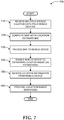
FIG 6 . illustrates an example computing device, where embodiments may be implemented; and -
FIG. 7 illustrates a logic flow diagram for a process of using mobile devices to gather mobile location data to generate a dynamic map for accurately and continuously determining locations of other mobile devices. - As briefly described above, mobile location data may be gathered using mobile devices enabled with Global Positioning Systems (GPS) and their reception of cellular tower signal information or other wireless signal information, such as WLANs, or other comparable systems. Such data may then be used to build a continuous and dynamic map of an area within a cellular network of cellular towers, WLAN origination spots, other wireless signals and their relation to accurate GPS locations. A system according to embodiments may utilize other location detection mechanisms as well. For example, short range signals such as Bluetooth that may mark locations (e.g. stores), location recognition by matching images, taken by an imaging capable device, audio recognition (e.g. the sound of a clock tower, ambient noise, etc. may be compared to sounds in a pre-recorded library), and comparable ones. Any information such as the ones described above may be added to the location map. In addition, an accelerometer and/or a compass integrated into the mobile device may also be used to as a location determination source. An accurate location of any mobile device within an area or landscape may then be determined using the dynamic map of the landscape and interpolation of points on the map using algorithms and mapping techniques. In the following detailed description, references are made to the accompanying drawings that form a part hereof, and in which are shown by way of illustrations specific embodiments or examples. These aspects may be combined, other aspects may be utilized, and structural changes may be made without departing from the spirit or scope of the present disclosure. The following detailed description is therefore not to be taken in a limiting sense, and the scope of the present invention is defined by the appended claims and their equivalents.
- While the embodiments will be described in the general context of program modules that execute in conjunction with an application program that runs on an operating system on a computing device or mobile device, those skilled in the art will recognize that aspects may also be implemented in combination with other program modules.
- Generally, program modules include routines, programs, components, data structures, and other types of structures that perform particular tasks or implement particular abstract data types. Moreover, those skilled in the art will appreciate that embodiments may be practiced with other computer system configurations, including hand-held devices, multiprocessor systems, microprocessor-based or programmable consumer electronics, minicomputers, mainframe computers, and comparable computing devices. Embodiments may also be practiced in distributed computing environments where tasks are performed by remote processing devices that are linked through a communications network. In a distributed computing environment, program modules may be located in both local and remote memory storage devices.
- Embodiments may be implemented as a computer-implemented process (method), a computing system, or as an article of manufacture, such as a computer program product or computer readable media. The computer program product may be a computer storage medium readable by a computer system and encoding a computer program that comprises instructions for causing a computer or computing system to perform example process(es). The computer-readable storage medium can for example be implemented via one or more of a volatile computer memory, a non-volatile memory, a hard drive, a flash drive, a floppy disk, or a compact disk, and comparable media. The computer program product may also be a propagated signal on a carrier (e.g. a frequency or phase modulated signal) or medium readable by a computing system and encoding a computer program of instructions for executing a computer process.
- Throughout this specification, the term "platform" may be a combination of software and hardware components for using signal information and positioning data to generate a dynamic map to locate mobile devices in a geographic area. Examples of platforms include, but are not limited to, a hosted service executed over a plurality of servers, an application executed on a single server, and comparable systems. The term "server" refers to a computing device executing one or more software programs typically in a networked environment. More detail on these technologies and example operations is provided below.
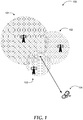
- Referring to
FIG. 1 , diagram 100 illustrates an example cellular triangulation technique for locating a mobile device within a cell. Cellular triangulation uses signal analysis data to calculate the time it takes signals to travel from amobile device 104 to at least three cellular towers (101, 102, and 103). Thefirst tower 101 detects themobile device 104 within a certain radius of its signal, and thesecond tower 102 detects themobile device 104 within a certain radius of its signal, and thethird tower 103 then detects themobile device 104 within a certain radius of its signal. The area where each radius overlaps is the approximate location of the mobile device. Cellular Triangulation does not take into account obstacles or impedances such as buildings and weather conditions, and the accuracy of the mobile device's location is relatively low. Any platform, network, or computing device may perform the signal analysis, once the mobile device communicates the signal data to the network or computing device. - Triangulation is not limited to cellular towers, but can also be used with other wireless signals such as Wireless Local Area Networks (WLAN), which transmit wireless signals that are received by mobile devices. Mobile devices can then be detected in an area in which the mobile device receives signals from at least three different WLANs or identifiable transmitters (e.g. repeaters) of the same WLAN. Measurement of the signal strength and computation of the triangulated location may be performed at the mobile device or at another device coupled to the network as discussed above.
- In
FIG. 2 , diagram 200 illustrates an example environment, where various mobile devices employ different signal sources for determining their locations. Of the mobile devices, some may be enabled to connect to GPS and others to WLANs. All mobile devices may be connected tocellular network 204. While the example illustration is focused on cellular network based mobile devices, embodiments are not limited to those. Indeed, embodiments may be implemented with mobile devices that can utilize any one of GPS, WLAN, and cellular network signals to determine their location, as well as various combinations of the three signal sources. Other network types such as Wide Area Networks (WANs) or short range signals from Personal Area Networks (PANs) or similar small networks may also be utilized to estimate mobile device locations using the principles described herein. Furthermore, matching images or audio captured by the mobile devices, integrated position devices such as accelerometers or compasses may be employed to enhance location determination. According to further embodiments, mobile devices may be "tethered". For example, if two acquaintances are near each other, only one may need to run the geo-location application. The other can "tether" their live location. -
Mobile device 203 exemplifies the common cellular phone based device in a network, which only senses and receives signals fromcellular towers 205. Thus, the local position of such devices can only be determined using techniques such as cellular triangulation. A system according to embodiments relies on comparison of different location determination techniques for increasing accuracy of techniques such as cellular triangulation. Therefore,mobile device 203 may be useful to the data collection portion of the system if it has a secondary method of determining its location (e.g. a stationary device at a known location). On the other hand,mobile device 203 may utilize an output of the system, a dynamic map of location based data points including signal information such as cellular signal values, thereby determining its location accurately based on the cellular signal readings at the device. -
Mobile device 202 is an example of a mobile device enabled with a satellite-based positioning system such as aGPS service 201. Mobile devices enabled with GPS may calculate their precise geographic location of the device using theGPS service 201. TheGPS service 201 calculates the location by timing signals sent by GPS satellites and communicates the specific position signal to themobile device 202. Once themobile device 202 receives an accurate position signal from GPS, the device may store its accurate geographical location. Simultaneously, themobile device 202 receives signals from thecellular towers 205 and may stores signal strength data from each cellular tower within its range.Mobile device 202 may communicate viacellular network 204 to a hostedservice 206 orindividual server 211 and send its precise geographical location provided by GPS and the signal strength data from cellular towers for processing. -
Mobile device 207 exemplifies a mobile device, which is connected to variouscellular towers 205 viacellular network 204 and also receives signals fromWLAN 208. Mobile devices enabled to receiveWLAN signals 208 can be used to estimate the mobile device's position through similar triangulation techniques or other algorithms where the basis for the triangulation is the WLAN signal location. In addition to triangulation,mobile device 208 may also determine its location based on an identity ofWLAN 208 if the network is a relatively small one such as a home network or a hot spot. Once the device receives signal information fromWLAN 208, it may communicate this data to the hostedservice 206 orserver 211, which may use the WLAN based and cellular triangulation based data to create a data point in the dynamic map of locations. -
Mobile device 209 is a device enabled withGPS 210 and connected toWLAN 212.Mobile device 209 also receives continuous signals from variouscellular towers 205 and is connected tocellular network 204.Mobile device 209 may report to hostedservice 206 and/orserver 211 signal strength information associated withcellular towers 205,WLAN 212, its GPS based location, and any additional position information signals providing multiple sources of information. The information may then be used to add a data point to a dynamic map of locations and associated signal strengths / types. -
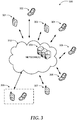
FIG. 3 illustrates a network, where a location determination service may receive data from mobile devices connected to cellular towers, WLANs, and/or GPS. As discussed above, various mobile devices (301 through 307) may collect and report location information based on different sources. The location information may include longitude/latitude information provided by a GPS service, signal strength and/or identity information associated with cellular or data networks, and comparable ones. Some of the data such as cellular triangulation information may not be as accurate as others, but by correlating data from different sources, an accuracy of location information for each device may be increased. - The information received from
mobile devices 301 through 307 atservers 309 via network(s) 310 may be processed to generate a database of locations and corresponding signal strengths / source identities (e.g. WLAN identity, cell tower identity). Then, a dynamic map of locations and corresponding signal strengths / source identities may be created. According to some embodiments, additional data points for the map may be generated by extrapolating data from existing received data. -
Servers 309 may transmit the map tomobile devices 308, which may use it to determine their locations accurately and continuously by evaluating signal strengths and source identities against comparable ones on the map. The map may be a dynamic one updated as new information frommobile devices 301 through 307 is collected, new extrapolations performed, and/or old data decays with time (e.g. by weighting). This way,mobile devices 308 do not have to activate and use energy consuming GPS continuously to determine their location accurately. Even ifmobile devices 308 do not have GPS capability, they can still determine their location with relatively high accuracy based on cellular or other network signals. According to other embodiments, the location determination process may be further enhanced by sporadic GPS readings in devices equipped with GPS capability (but not continuous use). - The example systems in
FIG. 1 through 3 have been described with specific servers, mobile devices, networks, and interactions. Embodiments are not limited to systems according to these example configurations. A network containing various wireless connections and devices for communication may be implemented in configurations employing fewer or additional location measuring components and performing other tasks. Furthermore, specific protocols and/or interfaces may be implemented in a similar manner using the principles described. -
FIG. 4 is a block diagram of an example mobile device operating environment and server computing environment, where network communication and processing of mobile location data to generate a dynamic map according to embodiments may be implemented. The mobile device operating environment may include amobile device 420 connected tocellular service 402,GPS service 401, orwireless networks 403, which may interact with themobile device 420 to provide mobile location data and other services. -
Mobile device 420 may include a mobilelocation data module 423 for obtaining data related to a mobile location or geographical position of the mobile device, such as GPS specific location of the mobile device or the cellular tower signal strength of surrounding cellular towers, or the signal strength of surrounding WLAN spots. Themobile device 420 may continuously gather and store mobile location data and signal strength data and then communicate the mobile location data toserver 410 via the cellular network or another wireless network. Because transmitting information can be energy costly, the device may send updates when it has access to an accurate location (e.g. GPS) to update the dynamic map, and occasionally when it does not have access to GPS. A dynamic mobilelocation mapping module 413 ofserver 410 may store and process the location data to build a dynamic map of mobile locations. -
Mobile device 420 andserver 410 may communicate through theirrespective communication applications Server 410 may accumulate mobile location data samples to create a map of mobile devices within the area and their GPS positions relative to cellular towers and/or WLANs and signal strengths. As the sampled data points are accumulated by theserver 410, dynamic mobilelocation mapping module 413 may process the samples and add them to the database to generate a continuous mapping and a dynamic view of the cellular landscape. Various operational aspects ofserver 410 may controlled through itsuser interface 414. -
Server 410 may also provide the dynamic map tomobile device 420 enabling it to compare its signal strength information to the data points on the map and accurately determine its own position even in the absence of accurate location data such as GPS data. To optimize transmission and storage/processing at themobile device 420,server 410 may compress the map prior to transmission using various compression techniques such as principal component analysis (PCA). Dynamic mobilelocation mapping module 413 may also interpolate received data points and extrapolate additional data points based on its computations. This approach may be especially useful in regions with few data points (e.g. rural areas with sparse mobile devices) or in regions, where data from cellular networks or WLANs may be skewed due to geographical impediments, weather conditions, etc. -
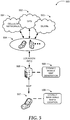
FIG. 5 includes conceptual diagram 500 illustrating use of location information from a plurality of mobile devices in creating a dynamic map to be used for accurate and continuous location determination by other mobile devices. As discussed previously, a framework for enabling accurate and/or continuous location determination of mobile devices without continuous use of accurate location services such as GPS includes three main components. - The first component includes
mobile devices 504, which may receive location information from a variety of sources such ascellular networks 501,GPS service 502,WLANs 503, and comparable ones. Some of themobile devices 504 may receive location information from a single source while others may receive location information from a combination of two or more sources.Mobile devices 504 may report their location information (i.e. location from GPS, signal strength and source identity from various cell towers, signal strength and source identity from various WLANs and their transmitters in case of WLANs with multiple transmitters) toserver 505, which may execute a mapping application that generates a dynamicmobile location map 506. The map may include data points reflecting locations and corresponding signal strength / source identity information for cellular networks and/or WLANs. - The dynamic
mobile location map 506 may be transmitted to amobile device 507, where the locally maintainedmap 508 may be used to determine the mobile device's location accurately by comparing signal strength / source identity information from cellular networks and/or WLANs. The information detected by themobile device 507 may be compared to data points and a corresponding location determined. This way,mobile device 507 may determine its location accurately (and continuously) without continuous use of a service like GPS. The locally maintainedmap 508 may be updated periodically, on demand, or upon changes in the master map at theserver 505. - According to some embodiments measures may be taken to protect privacy of mobile device users and/or to protect the cellular network from contamination with malicious input of mobile location data. One such measure may include assigning identifiers to each mobile device in an anonymous manner such that the identity of the device cannot be traced back to its user. The cellular network may then keep a record of the origination of sample points of mobile location data. Input from mobile devices may be weighted based on their "reputation", e.g. past history of providing truthful or reliable location information.
-
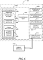
FIG. 6 and the associated discussion are intended to provide a brief, general description of a suitable computing environment in which embodiments may be implemented. With reference toFIG. 6 , a block diagram of an example computing operating environment for an application according to embodiments is illustrated, such ascomputing device 600. In a basic configuration,computing device 600 may be any computing device executing an application capable of using mobile location data to generate a dynamic mobile location map according to embodiments and include at least oneprocessing unit 602 andsystem memory 604.Computing device 600 may also include a plurality of processing units that cooperate in executing programs. Depending on the exact configuration and type of computing device, thesystem memory 604 may be volatile (such as RAM), non-volatile (such as ROM, flash memory, etc.) or some combination of the two.System memory 604 typically includes anoperating system 605 suitable for controlling the operation of the platform, such as the WINDOWS® operating systems from MICROSOFT CORPORATION of Redmond, Washington. Thesystem memory 604 may also include one or more software applications such asprogram modules 606,application 622, and dynamic mobilelocation mapping module 624. -
Application 622 may enable the cellular network to accumulate sample mobile location data frommobile devices 618 users to generate a continuous and dynamic map of mobile location data. Through the dynamic mobilelocation mapping module 624, a continuous map of mobile devices locations and varying cellular tower signal strengths may be generated in order to provide a map for interpolating the locations of other mobile devices within the cellular network landscape. The dynamic mobilelocation mapping module 624 may continuously accumulate sample points from multiple mobile devices in the network as they move throughout the network and may dynamically update the data as it receives new samples.Application 622 and dynamic mobilelocation mapping module 624 may be separate applications or integrated modules of a hosted service. This basic configuration is illustrated inFIG. 6 by those components within dashedline 608. -
Computing device 600 may have additional features or functionality. For example, thecomputing device 600 may also include additional data storage devices (removable and/or non-removable) such as, for example, magnetic disks, optical disks, or tape. Such additional storage is illustrated inFIG. 6 byremovable storage 609 andnon-removable storage 610. Computer readable storage media may include volatile and nonvolatile, removable and non-removable media implemented in any method or technology for storage of information, such as computer readable instructions, data structures, program modules, or other data.System memory 604,removable storage 609 andnon-removable storage 610 are all examples of computer readable storage media. Computer readable storage media includes, but is not limited to, RAM, ROM, EEPROM, flash memory or other memory technology, CD-ROM, digital versatile disks (DVD) or other optical storage, magnetic tape, magnetic disk storage or other magnetic storage devices, or any other medium which can be used to store the desired information and which can be accessed by computingdevice 600. Any such computer readable storage media may be part ofcomputing device 600.Computing device 600 may also have input device(s) 612 such as keyboard, mouse, pen, voice input device, touch input device, and comparable input devices. Output device(s) 614 such as a display, speakers, printer, and other types of output devices may also be included. These devices are well known in the art and need not be discussed at length here. -
Computing device 600 may also containcommunication connections 616 that allow the device to communicate with other devices, such asmobile devices 618 over a wired or wireless network in a distributed computing environment, a satellite link, a cellular link, a short range network, and comparable mechanisms.Mobile devices 618 may include cellular phones, smart phones, vehicle mount mobile devices, handheld computers, and comparable devices. Communication connection(s) 616 is one example of communication media. Communication media can include therein computer readable instructions, data structures, program modules, or other data. By way of example, and not limitation, communication media includes wired media such as a wired network or direct-wired connection, and wireless media such as acoustic, RF, infrared and other wireless media. - Example embodiments also include methods. These methods can be implemented in any number of ways, including the structures described in this document. One such way is by machine operations, of devices of the type described in this document.
- Another optional way is for one or more of the individual operations of the methods to be performed in conjunction with one or more human operators performing some. These human operators need not be collocated with each other, but each can be only with a machine that performs a portion of the program.
-
FIG. 7 illustrates a logic flow diagram forprocess 700 of using mobile devices to gather mobile location data to generate a dynamic map for accurately and continuously determining locations of other mobile devices.Process 700 may be implemented on a server or other computing device. -
Process 700 begins withoperation 710, where location data is received from various mobile devices within a cellular network connected to at least one of Global Positioning Systems (GPS), Wireless Local Area Networks (WLAN) or cellular towers. The mobile devices may gather mobile location data from each available source including specific geographical location data from GPS and varying signal strengths / source identities from WLANs and/or cellular towers. Atoperation 720, a dynamic map may be created based on the received location data. The map may include locations and corresponding signal strength / source identity information. The map may further include extrapolated data points based on received ones. - At
operation 730, the map may be provided to a mobile device by the server. For optimization of transmission and storage at the mobile device, the map may be compressed using a variety of compression techniques. Atoperation 740, the mobile device may be enabled to determine its location by comparing a signal strength and source identity for the signal to one or more corresponding ones on the map allowing the mobile device to determine its location accurately and continuously without having accurate location data such as GPS data. Atoperation 750, the location information may be received from the mobile device and a location based service provided to the mobile device atoptional operation 760 based on the received location information. - The operations included in
process 700 are for illustration purposes. Gathering mobile location information, communicating mobile location information, generating mobile location maps and interpreting the maps for location based services may be implemented by similar processes with fewer or additional steps, as well as in different order of operations using the principles described herein. - The above specification, examples and data provide a complete description of the manufacture and use of the composition of the embodiments. Although the subject matter has been described in language specific to structural features and/or methodological acts, it is to be understood that the subject matter defined in the appended claims is not necessarily limited to the specific features or acts described above. Rather, the specific features and acts described above are disclosed as example forms of implementing the claims and embodiments.
Claims (13)
- A method executed at least in part in a computing device for determining accurate location of a mobile device, the method comprising:receiving (710) mobile location data associated with a plurality of mobile devices;creating (720) a dynamic map of mobile device locations within a cellular network region, wherein the map includes one or more distinct signal types for each location;transmitting (730) the map to a mobile device; andenabling (740) accurate estimation of the mobile device's location by comparison of at least one of the distinct signal types to a current signal received by the mobile device at its current location employing the data in the map;the method characterized by:assigning identifiers to each mobile device in an anonymous manner such that the identity of the device cannot be traced back to its user;keeping a record of the origination of sample points of mobile location data; andweighting input from mobile devices based on their past history of providing truthful or reliable location information.
- The method of claim 1, further comprising:receiving (750) estimated location data from the mobile device; andproviding (760) a location based service to a user of the mobile device based on the estimated location.
- The method of claim 1, wherein creating the dynamic map includes:
creating a database of mobile location data comparing distinct signal types for each location. - The method of claim 3, wherein the distinct signal types include Global Positioning System, GPS, data, cell tower triangulation data, and Wireless Local Area Network, WLAN, location data.
- The method of claim 1, further comprising:
enabling the plurality of mobile devices to transmit their mobile location data automatically. - The method of claim 5, further comprising:dynamically updating the map; andtransmitting dynamic updates to the mobile device such that a location of the mobile device is continuously determined.
- The method of claim 1, further comprising:creating a plurality of dynamic maps for distinct regions based on the dynamic database; andin response to receiving a GPS based location from a mobile device, transmitting a map corresponding to the mobile device's location.
- The method of claim 4, further comprising:
creating the map by extrapolating additional data points based on value pairs of GPS locations and one of cell tower triangulation and WLAN signals received from the plurality of mobile devices. - The method of any one of the preceding claims, wherein the mobile device is one of: a cellular phone, a smart phone, a handheld computer, and a vehicle mount computer.
- The method of any one of the preceding claims, further comprising:compressing the map;transmitting the compressed map to the mobile device.
- Computer-executable instructions that when executed on a computer cause the computer to perform the method according to any one of the preceding claims.
- Computer-readable storage medium storing the instructions of the preceding claim.
- System implementing the method according to any one of claims 1-10.
Applications Claiming Priority (2)
| Application Number | Priority Date | Filing Date | Title |
|---|---|---|---|
| US12/791,084 US8494566B2 (en) | 2010-06-01 | 2010-06-01 | Hybrid mobile phone geopositioning |
| PCT/US2011/037484 WO2011153013A2 (en) | 2010-06-01 | 2011-05-22 | Hybrid mobile phone geopositioning |
Publications (3)
| Publication Number | Publication Date |
|---|---|
| EP2578033A2 EP2578033A2 (en) | 2013-04-10 |
| EP2578033A4 EP2578033A4 (en) | 2017-01-11 |
| EP2578033B1 true EP2578033B1 (en) | 2018-08-22 |
Family
ID=45022551
Family Applications (1)
| Application Number | Title | Priority Date | Filing Date |
|---|---|---|---|
| EP11790195.9A Active EP2578033B1 (en) | 2010-06-01 | 2011-05-22 | Hybrid mobile phone geopositioning |
Country Status (8)
| Country | Link |
|---|---|
| US (1) | US8494566B2 (en) |
| EP (1) | EP2578033B1 (en) |
| JP (1) | JP5726297B2 (en) |
| KR (1) | KR101726019B1 (en) |
| CN (1) | CN102907151B (en) |
| AU (1) | AU2011261688B2 (en) |
| TW (1) | TWI469670B (en) |
| WO (1) | WO2011153013A2 (en) |
Families Citing this family (48)
| Publication number | Priority date | Publication date | Assignee | Title |
|---|---|---|---|---|
| AU2009337852A1 (en) * | 2009-01-14 | 2010-07-22 | Tomtom International B.V. | Navigation apparatus, location determination system and method of location determination |
| JP2012073088A (en) | 2010-09-28 | 2012-04-12 | Sony Corp | Position information providing device, position information providing method, position information providing system and program |
| US8606293B2 (en) * | 2010-10-05 | 2013-12-10 | Qualcomm Incorporated | Mobile device location estimation using environmental information |
| US8483725B2 (en) | 2010-12-03 | 2013-07-09 | Qualcomm Incorporated | Method and apparatus for determining location of mobile device |
| US20120172054A1 (en) * | 2011-01-05 | 2012-07-05 | Texas Instruments Incorporated | System and method for cooperative positioning |
| US9143571B2 (en) | 2011-03-04 | 2015-09-22 | Qualcomm Incorporated | Method and apparatus for identifying mobile devices in similar sound environment |
| US9880282B1 (en) * | 2011-03-31 | 2018-01-30 | Google Llc | Determining device location using multiple sources of location data |
| US20120329484A1 (en) * | 2011-06-23 | 2012-12-27 | Ariel Inventions Llc | Locating mobile devices utilizing wi-fi information |
| US9641978B2 (en) | 2011-08-18 | 2017-05-02 | Rivada Research, Llc | Method and system for providing enhanced location based information for wireless handsets |
| US20130046692A1 (en) * | 2011-08-19 | 2013-02-21 | Bank Of America Corporation | Fraud protection with user location verification |
| KR101796975B1 (en) * | 2011-09-30 | 2017-11-14 | 삼성전자주식회사 | System for sharing dlna network |
| US9372254B2 (en) * | 2011-10-31 | 2016-06-21 | Panasonic Intellectual Property Corporation Of America | Position estimation device, position estimation method, program and integrated circuit |
| US20150025838A1 (en) * | 2011-11-15 | 2015-01-22 | Panasonic Corporation | Position estimation device, position estimation method, and integrated circuit |
| US8635023B2 (en) | 2011-11-22 | 2014-01-21 | Google Inc. | Position indication controls for device locations |
| US8949439B1 (en) * | 2012-05-01 | 2015-02-03 | Google Inc. | Resource conscious tethering |
| US9113291B2 (en) | 2012-06-18 | 2015-08-18 | Qualcomm Incorporated | Location detection within identifiable pre-defined geographic areas |
| US10657768B2 (en) | 2012-06-22 | 2020-05-19 | Zonal Systems, Llc | System and method for placing virtual geographic zone markers |
| US9317996B2 (en) | 2012-06-22 | 2016-04-19 | II Robert L. Pierce | Method for authenticating a wager using a system and method for interacting with virtual geographic zones |
| US10360760B2 (en) | 2012-06-22 | 2019-07-23 | Zonal Systems, Llc | System and method for placing virtual geographic zone markers |
| US9786176B2 (en) | 2012-06-22 | 2017-10-10 | Zonal Systems, Llc | System and method for placing virtual geographic zone markers |
| IL224483A (en) * | 2013-01-29 | 2017-03-30 | Verint Systems Ltd | System and method for geography- based correlation of cellular and wlan identifiers |
| US20140259078A1 (en) | 2013-03-11 | 2014-09-11 | Universal Electronics Inc. | System and method for automatic channel lineup determination |
| US9110157B2 (en) * | 2013-03-12 | 2015-08-18 | Intel Corporation | Using multiple sources of location-aid data to determine position information |
| WO2014177165A1 (en) * | 2013-05-03 | 2014-11-06 | ALLUNITE ApS | Method of transmitting advertising content to a wireless access point |
| US9774992B2 (en) * | 2013-05-10 | 2017-09-26 | John Russell Wilbur | Software applications and website platform for recording, displaying and sharing receiver signal strengths and other parameters |
| US9585039B2 (en) * | 2013-05-10 | 2017-02-28 | John Russell Wilbur | Software applications for displaying and or recording receiver signal strengths and other parameters |
| CN103338444B (en) * | 2013-05-15 | 2015-11-04 | 浙江工商大学 | The vehicle position privacy protection method of vehicular ad hoc network |
| WO2014205098A1 (en) | 2013-06-19 | 2014-12-24 | Zoll Medical Corporation | Systems and methods of determining location using a medical device |
| KR102079033B1 (en) * | 2013-07-17 | 2020-04-07 | 삼성전자주식회사 | Mobile terminal and method for controlling place recognition |
| CN103747522B (en) * | 2013-12-31 | 2019-03-08 | 上海华为技术有限公司 | A kind of location information acquisition method and equipment |
| WO2016003516A2 (en) * | 2014-04-10 | 2016-01-07 | Massachusetts Institute Of Technology | Radio frequency localization |
| WO2016009016A1 (en) * | 2014-07-17 | 2016-01-21 | Koninklijke Philips N.V. | Method of obtaining gesture zone definition data for a control system based on user input |
| US9554241B2 (en) * | 2014-09-23 | 2017-01-24 | Google Inc. | Systems and methods for sharing location data within a vehicle |
| WO2016094681A1 (en) * | 2014-12-10 | 2016-06-16 | Rivada Research LLC | Method and system for providing enhanced location based information for wireless handsets |
| DE102015203616A1 (en) | 2015-02-27 | 2016-09-01 | Continental Teves Ag & Co. Ohg | Multipath detection by comparing two different GNSS signals |
| WO2016154274A2 (en) | 2015-03-24 | 2016-09-29 | Zoll Medical Corporation | Systems and methods of determining location using a medical device |
| JP6641614B2 (en) * | 2015-06-22 | 2020-02-05 | 本田技研工業株式会社 | Map information updating device and map information updating system |
| US10228445B2 (en) * | 2016-03-30 | 2019-03-12 | International Business Machines Corporation | Signal propagating positioning system |
| US10149269B2 (en) | 2016-08-08 | 2018-12-04 | Blackberry Limited | Mobile transceiver having route monitoring and method of operation |
| US10477505B2 (en) | 2016-08-08 | 2019-11-12 | Blackberry Limited | Mobile transceiver for asset tracking having a power saving scheme for network access |
| US20210120298A1 (en) | 2019-10-17 | 2021-04-22 | Universal Electronics Inc. | Systems and methods for a customized media access user experience |
| US11653050B2 (en) | 2019-10-17 | 2023-05-16 | Universal Electronics Inc. | Systems and methods for a customized media access user experience with privacy settings |
| US20220373692A1 (en) * | 2019-11-02 | 2022-11-24 | Gamania Digital Entertainment Co., Ltd. | Method for real and virtual combined positioning |
| US11388564B2 (en) * | 2019-12-11 | 2022-07-12 | Nec Corporation | Infrastructure-free RF tracking in dynamic indoor environments |
| US11343259B2 (en) | 2020-07-09 | 2022-05-24 | Bank Of America Corporation | Electronic system for dynamic stepped multi-level authentication |
| US11392684B2 (en) | 2020-07-09 | 2022-07-19 | Bank Of America Corporation | Authentication of user activities based on establishing communication links between network devices |
| US11582948B2 (en) * | 2020-07-21 | 2023-02-21 | Garrity Power Services Llc | Cattle tracking system |
| CN112136335A (en) * | 2020-07-23 | 2020-12-25 | 北京小米移动软件有限公司 | Positioning measurement method, positioning measurement device, and storage medium |
Family Cites Families (40)
| Publication number | Priority date | Publication date | Assignee | Title |
|---|---|---|---|---|
| US6272316B1 (en) | 1995-11-17 | 2001-08-07 | Globalstar L.P. | Mobile satellite user information request system and methods |
| US6167274A (en) * | 1997-06-03 | 2000-12-26 | At&T Wireless Svcs. Inc. | Method for locating a mobile station |
| US8078189B2 (en) * | 2000-08-14 | 2011-12-13 | Sirf Technology, Inc. | System and method for providing location based services over a network |
| JP4049558B2 (en) | 2001-08-06 | 2008-02-20 | 株式会社デンソー | Wireless communication terminal, computer program, and position-related information transmission method |
| DE10142953B4 (en) * | 2001-09-01 | 2010-08-05 | Harry-H. Evers | Method for locating with a mobile terminal |
| AUPS123702A0 (en) * | 2002-03-22 | 2002-04-18 | Nahla, Ibrahim S. Mr | The train navigtion and control system (TNCS) for multiple tracks |
| US7634156B2 (en) * | 2002-07-27 | 2009-12-15 | Archaio, Llc | System and method for rapid emergency information distribution |
| US7016673B2 (en) | 2002-10-01 | 2006-03-21 | Interdigital Technology Corporation | Wireless communication method and system with controlled WTRU peer-to-peer communications |
| US7440762B2 (en) | 2003-12-30 | 2008-10-21 | Trueposition, Inc. | TDOA/GPS hybrid wireless location system |
| US7688260B2 (en) * | 2004-08-26 | 2010-03-30 | Global Locate, Inc. | Method and apparatus for locating position of a mobile device in an assisted satellite positioning system |
| US8019352B2 (en) * | 2004-07-23 | 2011-09-13 | Wireless Valley Communications, Inc. | System, method, and apparatus for determining and using the position of wireless devices or infrastructure for wireless network enhancements |
| US8032156B2 (en) * | 2004-09-07 | 2011-10-04 | Qualcomm Incorporated | Procedure to increase position location availabilty |
| KR101099151B1 (en) | 2004-10-29 | 2011-12-27 | 스카이후크 와이어리스, 인크. | Location beacon database and server, method of building location beacon database, and location based service using same |
| US8565788B2 (en) * | 2005-02-03 | 2013-10-22 | Mexens Intellectual Property Holding Llc | Method and system for obtaining location of a mobile device |
| US20060264212A1 (en) * | 2005-05-20 | 2006-11-23 | Ramesh Sekhar | Method and system for a roam-less mobile unit |
| US7392017B2 (en) * | 2005-06-30 | 2008-06-24 | Google Inc. | Assessing wireless network quality |
| US7466986B2 (en) | 2006-01-19 | 2008-12-16 | International Business Machines Corporation | On-device mapping of WIFI hotspots via direct connection of WIFI-enabled and GPS-enabled mobile devices |
| US8014936B2 (en) * | 2006-03-03 | 2011-09-06 | Inrix, Inc. | Filtering road traffic condition data obtained from mobile data sources |
| JP4701133B2 (en) * | 2006-06-28 | 2011-06-15 | 株式会社エヌ・ティ・ティ・ドコモ | POSITION INFORMATION MANAGEMENT SERVER, MOBILE MANAGEMENT SYSTEM, AND POSITION INFORMATION MANAGEMENT METHOD |
| US8244240B2 (en) * | 2006-06-29 | 2012-08-14 | Microsoft Corporation | Queries as data for revising and extending a sensor-based location service |
| TW200805152A (en) * | 2006-07-06 | 2008-01-16 | Hong-Fu Li | Diverse tracing positioning system and its operation method |
| TW200828949A (en) * | 2006-12-18 | 2008-07-01 | Inventec Appliances Corp | Method of communication and transmission between global positioning system and mobile phone system |
| US8798639B2 (en) * | 2007-01-17 | 2014-08-05 | Qualcomm Incorporated | Method and apparatus for using historic network information for determining approximate position |
| US7751971B2 (en) * | 2007-01-17 | 2010-07-06 | Microsoft Corporation | Location mapping for key-point based services |
| DE102007028114A1 (en) | 2007-03-16 | 2008-09-25 | Fraunhofer-Gesellschaft zur Förderung der angewandten Forschung e.V. | Device and method for localization of terminals |
| US8478299B2 (en) | 2007-04-06 | 2013-07-02 | Hewlett-Packard Development Company, L.P. | System and methods for obtaining coarse location for a mobile device |
| US8185137B2 (en) * | 2007-06-25 | 2012-05-22 | Microsoft Corporation | Intensity-based maps |
| JP5006720B2 (en) * | 2007-07-04 | 2012-08-22 | 株式会社エヌ・ティ・ティ・ドコモ | Portable terminal position information transmission system and portable terminal position information transmission method |
| US8059028B2 (en) * | 2008-08-14 | 2011-11-15 | Trueposition, Inc. | Hybrid GNSS and TDOA wireless location system |
| US20110040625A1 (en) * | 2008-02-12 | 2011-02-17 | David Woodruff | System and method for advertising on a mobile device |
| TW200827761A (en) * | 2008-03-05 | 2008-07-01 | Kinpo Elect Inc | Portable positioning apparatus, positioning system and positioning method thereof |
| WO2009124348A1 (en) | 2008-04-07 | 2009-10-15 | Seeker Wireless Pty Limited | Efficient collection of wireless transmitter characteristics |
| US20090326815A1 (en) * | 2008-05-02 | 2009-12-31 | Apple Inc. | Position Fix Indicator |
| US20090280801A1 (en) * | 2008-05-09 | 2009-11-12 | Ajay Malik | Cell Sensor for Access Ports |
| AU2009249382A1 (en) | 2008-05-23 | 2009-11-26 | Commscope, Inc. Of North Carolina | System and method for locating WiMAX or LTE subscriber stations |
| WO2010005731A1 (en) | 2008-06-16 | 2010-01-14 | Skyhook Wireless, Inc. | Methods and systems for determining location using a cellular and wlan positioning system by selecting the best wlan ps solution |
| US8984150B2 (en) * | 2008-07-16 | 2015-03-17 | Ipass Inc. | Electronic supply chain management |
| US20100069086A1 (en) * | 2008-09-17 | 2010-03-18 | Sony Ericsson Mobile Communications Ab | Mobile Terminals Providing Network-Based Location Data, and Methods and Computer Program Product for Operating the Same |
| KR101602221B1 (en) * | 2009-05-19 | 2016-03-10 | 엘지전자 주식회사 | Mobile terminal system and control method thereof |
| TWI395970B (en) * | 2009-08-10 | 2013-05-11 | Ind Tech Res Inst | Method and apparatus for positioning mobile device |
-
2010
- 2010-06-01 US US12/791,084 patent/US8494566B2/en active Active
-
2011
- 2011-05-02 TW TW100115373A patent/TWI469670B/en not_active IP Right Cessation
- 2011-05-22 JP JP2013513210A patent/JP5726297B2/en not_active Expired - Fee Related
- 2011-05-22 CN CN201180027032.5A patent/CN102907151B/en active Active
- 2011-05-22 AU AU2011261688A patent/AU2011261688B2/en active Active
- 2011-05-22 EP EP11790195.9A patent/EP2578033B1/en active Active
- 2011-05-22 WO PCT/US2011/037484 patent/WO2011153013A2/en active Application Filing
- 2011-05-22 KR KR1020127031344A patent/KR101726019B1/en active IP Right Grant
Non-Patent Citations (1)
| Title |
|---|
| None * |
Also Published As
| Publication number | Publication date |
|---|---|
| AU2011261688B2 (en) | 2014-04-10 |
| KR20130120366A (en) | 2013-11-04 |
| WO2011153013A2 (en) | 2011-12-08 |
| US20110294515A1 (en) | 2011-12-01 |
| RU2012151506A (en) | 2014-06-10 |
| TW201206223A (en) | 2012-02-01 |
| KR101726019B1 (en) | 2017-04-11 |
| EP2578033A4 (en) | 2017-01-11 |
| AU2011261688A1 (en) | 2012-12-13 |
| EP2578033A2 (en) | 2013-04-10 |
| JP5726297B2 (en) | 2015-05-27 |
| CN102907151B (en) | 2014-07-30 |
| WO2011153013A3 (en) | 2012-02-23 |
| CN102907151A (en) | 2013-01-30 |
| US8494566B2 (en) | 2013-07-23 |
| JP2013533671A (en) | 2013-08-22 |
| TWI469670B (en) | 2015-01-11 |
Similar Documents
| Publication | Publication Date | Title |
|---|---|---|
| EP2578033B1 (en) | Hybrid mobile phone geopositioning | |
| LaMarca et al. | Place lab: Device positioning using radio beacons in the wild | |
| EP2883376B1 (en) | A system and method for measuring the crowdedness of people at a place | |
| CN103069858B (en) | The method of communication environments map and device thereof in generating building | |
| KR102317377B1 (en) | Systems and methods for using three-dimensional location information to improve location services | |
| US9078099B2 (en) | Localization method employing radio signal strength measurements of electric and gas meters | |
| US11243288B2 (en) | Location error radius determination | |
| JP2013533671A5 (en) | ||
| CN104081844A (en) | Method and apparatus for locating mobile device by using mobile device orientation | |
| WO2014120469A1 (en) | Reducing location search space | |
| US20090075675A1 (en) | Method of location based service and location based service system | |
| JP2012107977A (en) | Position estimation device, system, position estimation method and position estimation program | |
| Meneses et al. | Radio maps for fingerprinting in indoor positioning | |
| TW201140123A (en) | Locating electromagnetic signal sources | |
| RU2574602C2 (en) | Hybrid geopositioning of mobile phone | |
| CN112153561B (en) | Blind guiding method and device | |
| Hamani et al. | Mobile location system using netmonitor and mappoint server |
Legal Events
| Date | Code | Title | Description |
|---|---|---|---|
| PUAI | Public reference made under article 153(3) epc to a published international application that has entered the european phase |
Free format text: ORIGINAL CODE: 0009012 |
|
| 17P | Request for examination filed |
Effective date: 20121101 |
|
| AK | Designated contracting states |
Kind code of ref document: A2 Designated state(s): AL AT BE BG CH CY CZ DE DK EE ES FI FR GB GR HR HU IE IS IT LI LT LU LV MC MK MT NL NO PL PT RO RS SE SI SK SM TR |
|
| REG | Reference to a national code |
Ref country code: HK Ref legal event code: DE Ref document number: 1177858 Country of ref document: HK |
|
| DAX | Request for extension of the european patent (deleted) | ||
| RAP1 | Party data changed (applicant data changed or rights of an application transferred) |
Owner name: MICROSOFT TECHNOLOGY LICENSING, LLC |
|
| A4 | Supplementary search report drawn up and despatched |
Effective date: 20161214 |
|
| RIC1 | Information provided on ipc code assigned before grant |
Ipc: G01S 19/12 20100101ALI20161208BHEP Ipc: H04W 64/00 20090101AFI20161208BHEP Ipc: G01S 5/02 20100101ALI20161208BHEP Ipc: H04W 4/02 20090101ALI20161208BHEP |
|
| GRAP | Despatch of communication of intention to grant a patent |
Free format text: ORIGINAL CODE: EPIDOSNIGR1 |
|
| STAA | Information on the status of an ep patent application or granted ep patent |
Free format text: STATUS: GRANT OF PATENT IS INTENDED |
|
| INTG | Intention to grant announced |
Effective date: 20180221 |
|
| GRAS | Grant fee paid |
Free format text: ORIGINAL CODE: EPIDOSNIGR3 |
|
| GRAA | (expected) grant |
Free format text: ORIGINAL CODE: 0009210 |
|
| STAA | Information on the status of an ep patent application or granted ep patent |
Free format text: STATUS: THE PATENT HAS BEEN GRANTED |
|
| AK | Designated contracting states |
Kind code of ref document: B1 Designated state(s): AL AT BE BG CH CY CZ DE DK EE ES FI FR GB GR HR HU IE IS IT LI LT LU LV MC MK MT NL NO PL PT RO RS SE SI SK SM TR |
|
| REG | Reference to a national code |
Ref country code: GB Ref legal event code: FG4D |
|
| REG | Reference to a national code |
Ref country code: CH Ref legal event code: EP |
|
| REG | Reference to a national code |
Ref country code: AT Ref legal event code: REF Ref document number: 1033979 Country of ref document: AT Kind code of ref document: T Effective date: 20180915 |
|
| REG | Reference to a national code |
Ref country code: IE Ref legal event code: FG4D |
|
| REG | Reference to a national code |
Ref country code: DE Ref legal event code: R096 Ref document number: 602011051353 Country of ref document: DE |
|
| REG | Reference to a national code |
Ref country code: NL Ref legal event code: FP |
|
| REG | Reference to a national code |
Ref country code: LT Ref legal event code: MG4D |
|
| PG25 | Lapsed in a contracting state [announced via postgrant information from national office to epo] |
Ref country code: GR Free format text: LAPSE BECAUSE OF FAILURE TO SUBMIT A TRANSLATION OF THE DESCRIPTION OR TO PAY THE FEE WITHIN THE PRESCRIBED TIME-LIMIT Effective date: 20181123 Ref country code: NO Free format text: LAPSE BECAUSE OF FAILURE TO SUBMIT A TRANSLATION OF THE DESCRIPTION OR TO PAY THE FEE WITHIN THE PRESCRIBED TIME-LIMIT Effective date: 20181122 Ref country code: BG Free format text: LAPSE BECAUSE OF FAILURE TO SUBMIT A TRANSLATION OF THE DESCRIPTION OR TO PAY THE FEE WITHIN THE PRESCRIBED TIME-LIMIT Effective date: 20181122 Ref country code: SE Free format text: LAPSE BECAUSE OF FAILURE TO SUBMIT A TRANSLATION OF THE DESCRIPTION OR TO PAY THE FEE WITHIN THE PRESCRIBED TIME-LIMIT Effective date: 20180822 Ref country code: FI Free format text: LAPSE BECAUSE OF FAILURE TO SUBMIT A TRANSLATION OF THE DESCRIPTION OR TO PAY THE FEE WITHIN THE PRESCRIBED TIME-LIMIT Effective date: 20180822 Ref country code: LT Free format text: LAPSE BECAUSE OF FAILURE TO SUBMIT A TRANSLATION OF THE DESCRIPTION OR TO PAY THE FEE WITHIN THE PRESCRIBED TIME-LIMIT Effective date: 20180822 Ref country code: RS Free format text: LAPSE BECAUSE OF FAILURE TO SUBMIT A TRANSLATION OF THE DESCRIPTION OR TO PAY THE FEE WITHIN THE PRESCRIBED TIME-LIMIT Effective date: 20180822 Ref country code: IS Free format text: LAPSE BECAUSE OF FAILURE TO SUBMIT A TRANSLATION OF THE DESCRIPTION OR TO PAY THE FEE WITHIN THE PRESCRIBED TIME-LIMIT Effective date: 20181222 |
|
| REG | Reference to a national code |
Ref country code: AT Ref legal event code: MK05 Ref document number: 1033979 Country of ref document: AT Kind code of ref document: T Effective date: 20180822 |
|
| PG25 | Lapsed in a contracting state [announced via postgrant information from national office to epo] |
Ref country code: AL Free format text: LAPSE BECAUSE OF FAILURE TO SUBMIT A TRANSLATION OF THE DESCRIPTION OR TO PAY THE FEE WITHIN THE PRESCRIBED TIME-LIMIT Effective date: 20180822 Ref country code: LV Free format text: LAPSE BECAUSE OF FAILURE TO SUBMIT A TRANSLATION OF THE DESCRIPTION OR TO PAY THE FEE WITHIN THE PRESCRIBED TIME-LIMIT Effective date: 20180822 Ref country code: HR Free format text: LAPSE BECAUSE OF FAILURE TO SUBMIT A TRANSLATION OF THE DESCRIPTION OR TO PAY THE FEE WITHIN THE PRESCRIBED TIME-LIMIT Effective date: 20180822 |
|
| PG25 | Lapsed in a contracting state [announced via postgrant information from national office to epo] |
Ref country code: EE Free format text: LAPSE BECAUSE OF FAILURE TO SUBMIT A TRANSLATION OF THE DESCRIPTION OR TO PAY THE FEE WITHIN THE PRESCRIBED TIME-LIMIT Effective date: 20180822 Ref country code: PL Free format text: LAPSE BECAUSE OF FAILURE TO SUBMIT A TRANSLATION OF THE DESCRIPTION OR TO PAY THE FEE WITHIN THE PRESCRIBED TIME-LIMIT Effective date: 20180822 Ref country code: RO Free format text: LAPSE BECAUSE OF FAILURE TO SUBMIT A TRANSLATION OF THE DESCRIPTION OR TO PAY THE FEE WITHIN THE PRESCRIBED TIME-LIMIT Effective date: 20180822 Ref country code: IT Free format text: LAPSE BECAUSE OF FAILURE TO SUBMIT A TRANSLATION OF THE DESCRIPTION OR TO PAY THE FEE WITHIN THE PRESCRIBED TIME-LIMIT Effective date: 20180822 Ref country code: AT Free format text: LAPSE BECAUSE OF FAILURE TO SUBMIT A TRANSLATION OF THE DESCRIPTION OR TO PAY THE FEE WITHIN THE PRESCRIBED TIME-LIMIT Effective date: 20180822 Ref country code: CZ Free format text: LAPSE BECAUSE OF FAILURE TO SUBMIT A TRANSLATION OF THE DESCRIPTION OR TO PAY THE FEE WITHIN THE PRESCRIBED TIME-LIMIT Effective date: 20180822 Ref country code: ES Free format text: LAPSE BECAUSE OF FAILURE TO SUBMIT A TRANSLATION OF THE DESCRIPTION OR TO PAY THE FEE WITHIN THE PRESCRIBED TIME-LIMIT Effective date: 20180822 |
|
| REG | Reference to a national code |
Ref country code: DE Ref legal event code: R097 Ref document number: 602011051353 Country of ref document: DE |
|
| PG25 | Lapsed in a contracting state [announced via postgrant information from national office to epo] |
Ref country code: SK Free format text: LAPSE BECAUSE OF FAILURE TO SUBMIT A TRANSLATION OF THE DESCRIPTION OR TO PAY THE FEE WITHIN THE PRESCRIBED TIME-LIMIT Effective date: 20180822 Ref country code: DK Free format text: LAPSE BECAUSE OF FAILURE TO SUBMIT A TRANSLATION OF THE DESCRIPTION OR TO PAY THE FEE WITHIN THE PRESCRIBED TIME-LIMIT Effective date: 20180822 Ref country code: SM Free format text: LAPSE BECAUSE OF FAILURE TO SUBMIT A TRANSLATION OF THE DESCRIPTION OR TO PAY THE FEE WITHIN THE PRESCRIBED TIME-LIMIT Effective date: 20180822 |
|
| PLBE | No opposition filed within time limit |
Free format text: ORIGINAL CODE: 0009261 |
|
| STAA | Information on the status of an ep patent application or granted ep patent |
Free format text: STATUS: NO OPPOSITION FILED WITHIN TIME LIMIT |
|
| 26N | No opposition filed |
Effective date: 20190523 |
|
| PG25 | Lapsed in a contracting state [announced via postgrant information from national office to epo] |
Ref country code: SI Free format text: LAPSE BECAUSE OF FAILURE TO SUBMIT A TRANSLATION OF THE DESCRIPTION OR TO PAY THE FEE WITHIN THE PRESCRIBED TIME-LIMIT Effective date: 20180822 |
|
| REG | Reference to a national code |
Ref country code: HK Ref legal event code: WD Ref document number: 1257798 Country of ref document: HK |
|
| REG | Reference to a national code |
Ref country code: CH Ref legal event code: PL |
|
| PG25 | Lapsed in a contracting state [announced via postgrant information from national office to epo] |
Ref country code: CH Free format text: LAPSE BECAUSE OF NON-PAYMENT OF DUE FEES Effective date: 20190531 Ref country code: LI Free format text: LAPSE BECAUSE OF NON-PAYMENT OF DUE FEES Effective date: 20190531 Ref country code: MC Free format text: LAPSE BECAUSE OF FAILURE TO SUBMIT A TRANSLATION OF THE DESCRIPTION OR TO PAY THE FEE WITHIN THE PRESCRIBED TIME-LIMIT Effective date: 20180822 |
|
| REG | Reference to a national code |
Ref country code: BE Ref legal event code: MM Effective date: 20190531 |
|
| PG25 | Lapsed in a contracting state [announced via postgrant information from national office to epo] |
Ref country code: LU Free format text: LAPSE BECAUSE OF NON-PAYMENT OF DUE FEES Effective date: 20190522 |
|
| PG25 | Lapsed in a contracting state [announced via postgrant information from national office to epo] |
Ref country code: TR Free format text: LAPSE BECAUSE OF FAILURE TO SUBMIT A TRANSLATION OF THE DESCRIPTION OR TO PAY THE FEE WITHIN THE PRESCRIBED TIME-LIMIT Effective date: 20180822 |
|
| PG25 | Lapsed in a contracting state [announced via postgrant information from national office to epo] |
Ref country code: IE Free format text: LAPSE BECAUSE OF NON-PAYMENT OF DUE FEES Effective date: 20190522 |
|
| PG25 | Lapsed in a contracting state [announced via postgrant information from national office to epo] |
Ref country code: BE Free format text: LAPSE BECAUSE OF NON-PAYMENT OF DUE FEES Effective date: 20190531 |
|
| PG25 | Lapsed in a contracting state [announced via postgrant information from national office to epo] |
Ref country code: PT Free format text: LAPSE BECAUSE OF FAILURE TO SUBMIT A TRANSLATION OF THE DESCRIPTION OR TO PAY THE FEE WITHIN THE PRESCRIBED TIME-LIMIT Effective date: 20181222 |
|
| PG25 | Lapsed in a contracting state [announced via postgrant information from national office to epo] |
Ref country code: CY Free format text: LAPSE BECAUSE OF FAILURE TO SUBMIT A TRANSLATION OF THE DESCRIPTION OR TO PAY THE FEE WITHIN THE PRESCRIBED TIME-LIMIT Effective date: 20180822 |
|
| PG25 | Lapsed in a contracting state [announced via postgrant information from national office to epo] |
Ref country code: HU Free format text: LAPSE BECAUSE OF FAILURE TO SUBMIT A TRANSLATION OF THE DESCRIPTION OR TO PAY THE FEE WITHIN THE PRESCRIBED TIME-LIMIT; INVALID AB INITIO Effective date: 20110522 Ref country code: MT Free format text: LAPSE BECAUSE OF FAILURE TO SUBMIT A TRANSLATION OF THE DESCRIPTION OR TO PAY THE FEE WITHIN THE PRESCRIBED TIME-LIMIT Effective date: 20180822 |
|
| PG25 | Lapsed in a contracting state [announced via postgrant information from national office to epo] |
Ref country code: MK Free format text: LAPSE BECAUSE OF FAILURE TO SUBMIT A TRANSLATION OF THE DESCRIPTION OR TO PAY THE FEE WITHIN THE PRESCRIBED TIME-LIMIT Effective date: 20180822 |
|
| P01 | Opt-out of the competence of the unified patent court (upc) registered |
Effective date: 20230512 |
|
| PGFP | Annual fee paid to national office [announced via postgrant information from national office to epo] |
Ref country code: NL Payment date: 20230419 Year of fee payment: 13 |
|
| PGFP | Annual fee paid to national office [announced via postgrant information from national office to epo] |
Ref country code: FR Payment date: 20230420 Year of fee payment: 13 Ref country code: DE Payment date: 20230419 Year of fee payment: 13 |
|
| PGFP | Annual fee paid to national office [announced via postgrant information from national office to epo] |
Ref country code: GB Payment date: 20230420 Year of fee payment: 13 |