EP2570772A1 - Procédé pour la localisation et la cartographie de piétons ou de robots au moyen de points d'accès sans fil - Google Patents
Procédé pour la localisation et la cartographie de piétons ou de robots au moyen de points d'accès sans fil Download PDFInfo
- Publication number
- EP2570772A1 EP2570772A1 EP12157532A EP12157532A EP2570772A1 EP 2570772 A1 EP2570772 A1 EP 2570772A1 EP 12157532 A EP12157532 A EP 12157532A EP 12157532 A EP12157532 A EP 12157532A EP 2570772 A1 EP2570772 A1 EP 2570772A1
- Authority
- EP
- European Patent Office
- Prior art keywords
- measurements
- particle
- robot
- access points
- rss
- Prior art date
- Legal status (The legal status is an assumption and is not a legal conclusion. Google has not performed a legal analysis and makes no representation as to the accuracy of the status listed.)
- Withdrawn
Links
- 238000000034 method Methods 0.000 title claims abstract description 20
- 230000004807 localization Effects 0.000 title claims abstract description 16
- 238000013507 mapping Methods 0.000 title claims abstract description 16
- 238000005259 measurement Methods 0.000 claims abstract description 85
- 239000002245 particle Substances 0.000 claims abstract description 42
- 238000009826 distribution Methods 0.000 claims abstract description 11
- 230000000644 propagated effect Effects 0.000 claims abstract 4
- 238000007476 Maximum Likelihood Methods 0.000 claims abstract 2
- 230000001788 irregular Effects 0.000 claims abstract 2
- 238000005070 sampling Methods 0.000 claims description 7
- 238000001514 detection method Methods 0.000 claims description 3
- 238000001914 filtration Methods 0.000 claims description 2
- 238000007781 pre-processing Methods 0.000 claims 4
- 238000013450 outlier detection Methods 0.000 claims 1
- 238000013138 pruning Methods 0.000 claims 1
- 230000006870 function Effects 0.000 description 11
- 235000012489 doughnuts Nutrition 0.000 description 8
- 238000013459 approach Methods 0.000 description 6
- 238000002474 experimental method Methods 0.000 description 6
- 239000011159 matrix material Substances 0.000 description 6
- 239000000203 mixture Substances 0.000 description 5
- 230000008901 benefit Effects 0.000 description 4
- 230000004927 fusion Effects 0.000 description 4
- 230000003068 static effect Effects 0.000 description 4
- 238000010586 diagram Methods 0.000 description 3
- 230000000694 effects Effects 0.000 description 3
- 230000003993 interaction Effects 0.000 description 3
- 230000033001 locomotion Effects 0.000 description 3
- 238000012545 processing Methods 0.000 description 3
- 238000000060 site-specific infrared dichroism spectroscopy Methods 0.000 description 3
- 239000000654 additive Substances 0.000 description 2
- 230000000996 additive effect Effects 0.000 description 2
- 230000001364 causal effect Effects 0.000 description 2
- 230000008859 change Effects 0.000 description 2
- 230000000875 corresponding effect Effects 0.000 description 2
- 238000009472 formulation Methods 0.000 description 2
- 230000006872 improvement Effects 0.000 description 2
- 238000013519 translation Methods 0.000 description 2
- IKOKHHBZFDFMJW-UHFFFAOYSA-N 2-[4-[2-(2,3-dihydro-1H-inden-2-ylamino)pyrimidin-5-yl]-3-(2-morpholin-4-ylethoxy)pyrazol-1-yl]-1-(2,4,6,7-tetrahydrotriazolo[4,5-c]pyridin-5-yl)ethanone Chemical compound C1C(CC2=CC=CC=C12)NC1=NC=C(C=N1)C=1C(=NN(C=1)CC(=O)N1CC2=C(CC1)NN=N2)OCCN1CCOCC1 IKOKHHBZFDFMJW-UHFFFAOYSA-N 0.000 description 1
- 241000197200 Gallinago media Species 0.000 description 1
- 241000282412 Homo Species 0.000 description 1
- 238000012952 Resampling Methods 0.000 description 1
- 238000004458 analytical method Methods 0.000 description 1
- 230000004888 barrier function Effects 0.000 description 1
- 230000005540 biological transmission Effects 0.000 description 1
- 238000004891 communication Methods 0.000 description 1
- 230000002596 correlated effect Effects 0.000 description 1
- 230000001186 cumulative effect Effects 0.000 description 1
- 230000001419 dependent effect Effects 0.000 description 1
- 238000009795 derivation Methods 0.000 description 1
- 238000013461 design Methods 0.000 description 1
- 238000005516 engineering process Methods 0.000 description 1
- 230000014509 gene expression Effects 0.000 description 1
- 230000010354 integration Effects 0.000 description 1
- 230000005055 memory storage Effects 0.000 description 1
- 230000006855 networking Effects 0.000 description 1
- 230000003287 optical effect Effects 0.000 description 1
- 238000013139 quantization Methods 0.000 description 1
- 238000012552 review Methods 0.000 description 1
- 230000035945 sensitivity Effects 0.000 description 1
- 238000004088 simulation Methods 0.000 description 1
- 238000000638 solvent extraction Methods 0.000 description 1
- 238000001228 spectrum Methods 0.000 description 1
- 238000012706 support-vector machine Methods 0.000 description 1
- 238000012360 testing method Methods 0.000 description 1
- 230000009466 transformation Effects 0.000 description 1
- 238000000844 transformation Methods 0.000 description 1
- 230000007704 transition Effects 0.000 description 1
- 230000017105 transposition Effects 0.000 description 1
- 230000001960 triggered effect Effects 0.000 description 1
- 238000009827 uniform distribution Methods 0.000 description 1
- 238000010200 validation analysis Methods 0.000 description 1
- 230000000007 visual effect Effects 0.000 description 1
Images


Classifications
-
- H—ELECTRICITY
- H04—ELECTRIC COMMUNICATION TECHNIQUE
- H04W—WIRELESS COMMUNICATION NETWORKS
- H04W64/00—Locating users or terminals or network equipment for network management purposes, e.g. mobility management
-
- G—PHYSICS
- G01—MEASURING; TESTING
- G01C—MEASURING DISTANCES, LEVELS OR BEARINGS; SURVEYING; NAVIGATION; GYROSCOPIC INSTRUMENTS; PHOTOGRAMMETRY OR VIDEOGRAMMETRY
- G01C21/00—Navigation; Navigational instruments not provided for in groups G01C1/00 - G01C19/00
- G01C21/10—Navigation; Navigational instruments not provided for in groups G01C1/00 - G01C19/00 by using measurements of speed or acceleration
- G01C21/12—Navigation; Navigational instruments not provided for in groups G01C1/00 - G01C19/00 by using measurements of speed or acceleration executed aboard the object being navigated; Dead reckoning
- G01C21/16—Navigation; Navigational instruments not provided for in groups G01C1/00 - G01C19/00 by using measurements of speed or acceleration executed aboard the object being navigated; Dead reckoning by integrating acceleration or speed, i.e. inertial navigation
- G01C21/165—Navigation; Navigational instruments not provided for in groups G01C1/00 - G01C19/00 by using measurements of speed or acceleration executed aboard the object being navigated; Dead reckoning by integrating acceleration or speed, i.e. inertial navigation combined with non-inertial navigation instruments
-
- G—PHYSICS
- G01—MEASURING; TESTING
- G01C—MEASURING DISTANCES, LEVELS OR BEARINGS; SURVEYING; NAVIGATION; GYROSCOPIC INSTRUMENTS; PHOTOGRAMMETRY OR VIDEOGRAMMETRY
- G01C21/00—Navigation; Navigational instruments not provided for in groups G01C1/00 - G01C19/00
- G01C21/20—Instruments for performing navigational calculations
- G01C21/206—Instruments for performing navigational calculations specially adapted for indoor navigation
-
- G—PHYSICS
- G01—MEASURING; TESTING
- G01S—RADIO DIRECTION-FINDING; RADIO NAVIGATION; DETERMINING DISTANCE OR VELOCITY BY USE OF RADIO WAVES; LOCATING OR PRESENCE-DETECTING BY USE OF THE REFLECTION OR RERADIATION OF RADIO WAVES; ANALOGOUS ARRANGEMENTS USING OTHER WAVES
- G01S5/00—Position-fixing by co-ordinating two or more direction or position line determinations; Position-fixing by co-ordinating two or more distance determinations
- G01S5/02—Position-fixing by co-ordinating two or more direction or position line determinations; Position-fixing by co-ordinating two or more distance determinations using radio waves
- G01S5/0205—Details
- G01S5/0242—Determining the position of transmitters to be subsequently used in positioning
-
- G—PHYSICS
- G01—MEASURING; TESTING
- G01S—RADIO DIRECTION-FINDING; RADIO NAVIGATION; DETERMINING DISTANCE OR VELOCITY BY USE OF RADIO WAVES; LOCATING OR PRESENCE-DETECTING BY USE OF THE REFLECTION OR RERADIATION OF RADIO WAVES; ANALOGOUS ARRANGEMENTS USING OTHER WAVES
- G01S5/00—Position-fixing by co-ordinating two or more direction or position line determinations; Position-fixing by co-ordinating two or more distance determinations
- G01S5/02—Position-fixing by co-ordinating two or more direction or position line determinations; Position-fixing by co-ordinating two or more distance determinations using radio waves
- G01S5/0257—Hybrid positioning
- G01S5/0258—Hybrid positioning by combining or switching between measurements derived from different systems
- G01S5/02585—Hybrid positioning by combining or switching between measurements derived from different systems at least one of the measurements being a non-radio measurement
-
- G—PHYSICS
- G01—MEASURING; TESTING
- G01S—RADIO DIRECTION-FINDING; RADIO NAVIGATION; DETERMINING DISTANCE OR VELOCITY BY USE OF RADIO WAVES; LOCATING OR PRESENCE-DETECTING BY USE OF THE REFLECTION OR RERADIATION OF RADIO WAVES; ANALOGOUS ARRANGEMENTS USING OTHER WAVES
- G01S5/00—Position-fixing by co-ordinating two or more direction or position line determinations; Position-fixing by co-ordinating two or more distance determinations
- G01S5/02—Position-fixing by co-ordinating two or more direction or position line determinations; Position-fixing by co-ordinating two or more distance determinations using radio waves
- G01S5/0278—Position-fixing by co-ordinating two or more direction or position line determinations; Position-fixing by co-ordinating two or more distance determinations using radio waves involving statistical or probabilistic considerations
-
- G—PHYSICS
- G05—CONTROLLING; REGULATING
- G05D—SYSTEMS FOR CONTROLLING OR REGULATING NON-ELECTRIC VARIABLES
- G05D1/00—Control of position, course, altitude or attitude of land, water, air or space vehicles, e.g. using automatic pilots
- G05D1/02—Control of position or course in two dimensions
- G05D1/021—Control of position or course in two dimensions specially adapted to land vehicles
- G05D1/0268—Control of position or course in two dimensions specially adapted to land vehicles using internal positioning means
- G05D1/027—Control of position or course in two dimensions specially adapted to land vehicles using internal positioning means comprising intertial navigation means, e.g. azimuth detector
-
- G—PHYSICS
- G05—CONTROLLING; REGULATING
- G05D—SYSTEMS FOR CONTROLLING OR REGULATING NON-ELECTRIC VARIABLES
- G05D1/00—Control of position, course, altitude or attitude of land, water, air or space vehicles, e.g. using automatic pilots
- G05D1/02—Control of position or course in two dimensions
- G05D1/021—Control of position or course in two dimensions specially adapted to land vehicles
- G05D1/0268—Control of position or course in two dimensions specially adapted to land vehicles using internal positioning means
- G05D1/0272—Control of position or course in two dimensions specially adapted to land vehicles using internal positioning means comprising means for registering the travel distance, e.g. revolutions of wheels
-
- G—PHYSICS
- G05—CONTROLLING; REGULATING
- G05D—SYSTEMS FOR CONTROLLING OR REGULATING NON-ELECTRIC VARIABLES
- G05D1/00—Control of position, course, altitude or attitude of land, water, air or space vehicles, e.g. using automatic pilots
- G05D1/02—Control of position or course in two dimensions
- G05D1/021—Control of position or course in two dimensions specially adapted to land vehicles
- G05D1/0268—Control of position or course in two dimensions specially adapted to land vehicles using internal positioning means
- G05D1/0274—Control of position or course in two dimensions specially adapted to land vehicles using internal positioning means using mapping information stored in a memory device
-
- G—PHYSICS
- G05—CONTROLLING; REGULATING
- G05D—SYSTEMS FOR CONTROLLING OR REGULATING NON-ELECTRIC VARIABLES
- G05D1/00—Control of position, course, altitude or attitude of land, water, air or space vehicles, e.g. using automatic pilots
- G05D1/02—Control of position or course in two dimensions
- G05D1/021—Control of position or course in two dimensions specially adapted to land vehicles
- G05D1/0276—Control of position or course in two dimensions specially adapted to land vehicles using signals provided by a source external to the vehicle
- G05D1/0285—Control of position or course in two dimensions specially adapted to land vehicles using signals provided by a source external to the vehicle using signals transmitted via a public communication network, e.g. GSM network
-
- H—ELECTRICITY
- H04—ELECTRIC COMMUNICATION TECHNIQUE
- H04W—WIRELESS COMMUNICATION NETWORKS
- H04W4/00—Services specially adapted for wireless communication networks; Facilities therefor
- H04W4/02—Services making use of location information
- H04W4/029—Location-based management or tracking services
-
- H—ELECTRICITY
- H04—ELECTRIC COMMUNICATION TECHNIQUE
- H04W—WIRELESS COMMUNICATION NETWORKS
- H04W4/00—Services specially adapted for wireless communication networks; Facilities therefor
- H04W4/30—Services specially adapted for particular environments, situations or purposes
- H04W4/33—Services specially adapted for particular environments, situations or purposes for indoor environments, e.g. buildings
Definitions
- the present invention relates to a method for localization and mapping of pedestrians or robots using Wireless Access Points.
- SLAM is a very challenging topic with origins in the robotics community.
- a robot has to navigate in an unknown environment, relying on different kinds of sensors, e.g. inertial and optical ones [2], In [3] the robot has available RSS measurements from wireless nodes, whose positions are unknown. In this case it is shown that accurate mapping of the nodes improves also the positioning accuracy of the robot.
- FootSLAM [7] and PlaceSLAM [8] are two SLAM algorithms for pedestrians mainly based on step measurements collected by IMUs or other forms of odometry, However, convergence is not guaranteed, especially in open areas.
- a novel solution for a pedestrian SLAM is described which integrates RSS and/or TOA and/or TDOA measurements available within an IEEE 802.11 (WiFi) network in FootSLAM, showing that an improvement in FootSLAM convergence speed.
- WiFi IEEE 802.11
- FootSLAM uses a Bayesian estimation approach, where the state is the user's (pedestrian or robot) pose (position and heading) and step measurements (for humans, wheel or motor based-odometry measurements for robots) allow the updating of both the user trajectory and the environment map over time.
- the implementation employs a RBPF (Rao Blackwellised Particle Filter), where each particle is composed of both a user trajectory instance and its related map. This latter is obtained by partitioning the environment into hexagonal cells and estimating all the transitions probabilities for each visited cell. Extensive experiments show that convergence of both mapping and localization occurs when the user walks on closed loops and sufficient particles are used.
- the fusion of several datasets (Collaborative FootSLAM) is also dealt with in [15] and an example map is shown in Fig. 1 .
- PlaceSLAM In PlaceSLAM [8] proximity information relative to some well recognizable places, e.g. doors, is assumed. The places' locations are initially unknown and thus formally included in the map.
- the invention basically deals with the same framework as in FootSLAM, extending the Map space in a way similar to PlaceSLAM, such to include the WiFi map related to the detected APs, but without the disadvantages of PlaceSLAM (human interaction, whereas WiSLAM requires no human interaction).
- IEEE 802.11 is today the most used WLAN technology.
- the AP is the unit that forwards data towards the UE or to a connected network.
- beacon frames are periodically emitted by all APs for network tasks, such as the synchronization. Since the resolution of the clocks in off-the-shelf APs (about 1 ⁇ s) is too coarse for yielding an accurate distance estimation and MIMO antennas are not employed, both TOA and AOA techniques are not suitable, unless employing additive hardware, with a raising of the costs.
- DSSS Direct Sequence Spread Spectrum
- the RSS of the beacon frame emitted by the AP is measured by the receiver and made available to high level applications. Therefore, such information can be exploited by a localization system.
- the standard indicates 8 bit (256 levels) quantization for the RSSI measure, it does not define the resolution nor the accuracy of the measurement itself, that are normally unavailable to the user. Common resolutions are, however, -100 dBm to 0, with 1 dBm sized steps.
- the state-of-the-art knows TOA or TDOA solutions to estimate the distances from the AP (in the case of TOA) or a location hyperbola (for TDOA with a pair of APs).
- RSS measurements are employed, whose validation is given together with the results.
- the RSS measurements are considered from different APs independent given the user's position and, furthermore, AP's positions are independent. This allows us to compute the contribution of each AP independently. Moreover, different measurements from the same AP are also conditionally independent.
- h r k h - 20 ⁇ ⁇ ⁇ log 10 r k / d 0
- h the power emitted by the AP
- ⁇ the propagation exponent, usually varying from 2 (free space) up to 4 in real cases and do is a known reference distance. Note that both h and ⁇ are usually unknown, and h is found to vary strongly for different APs with dramatic effects on the mapping, unless it is learnt. This is why both x A p and h are introduced in the WiFi map.
- a similar likelihood function describing the probabilistic relationship between the location of the user and the measurement can be constructed trivially for TOA or TDOA measurements (a circular function for TOA like RSS for each AP and a hyperbola for TDOA for each pair of APs).
- SLAM was first applied to robots which may use several kinds of sensors, e.g. inertial ones and cameras [2].
- sensors e.g. inertial ones and cameras [2].
- the integration of RSS measurements from a WLAN is studied in [3]. Nevertheless, in this paper the overall accuracy is still due mainly to the inertial sensors.
- SLAM for pedestrians in indoor areas is based on the consideration that information on the environment map (walls, doors, etc) is very useful in improving the localization accuracy [4]-[6].
- FootSLAM [7] and PlaceSLAM [8] use a Bayesian estimation approach, where the state is the user's pose (position and heading) and step measurements (odometry) allow the updating of both the user trajectory and the environment map over time.
- step measurements odometry
- PlaceSLAM also proximity information relative to some well recognizable places, e,g. doors, is assumed to enhance the convergence capabilities.
- RSS-based indoor localization has been widely addressed in the past, and accuracies up to 2 meters are typically shown.
- the most used approaches are mainly based on fingerprinting (whose first implementation was RADAR [9]): 1) in a previous off line stage a radio map of the environment is built up with measurements collected over a set of known points and 2) in the localization stage the new RSS is compared to the stored ones to estimate the user's position.
- Other more recent approaches range from probabilistic techniques [10] to more complex models, e.g. support vector machines [11].
- RSS from both known and unknown APs are fused together within a probabilistic framework, showing an improvement in the localization accuracy, due to a discrete mapping ability for the unknown APs.
- the major drawbacks are that a partial knowledge of the map is in principle necessary and, moreover, the experimental results presented are quite poor.
- An object of the invention is to localize a pedestrian or robot within e.g. an indoor area, such as a building or within an area close to buildings or within an urban area.
- SLAM Simultaneous Localization and Mapping
- WiSLAM WiSLAM
- the fusion of odometry and RSS measurements will improve the performance obtained by other systems only employing odometry such as FootSLAM [7] and WO-A-2011/033100 .
- it is suited to speed up and stabilize their convergence and avoid their problems in open areas, since the old methods work on the peculiar hypothesis that the user runs the same loop many times and that the environment is sufficiently constrained by walls and other obstacles.
- the present invention relates to the subject matter of claim 1.
- the dependent claims relate to individual embodiments and aspects of the invention.
- WiSLAM makes only use of step and RSS measurements (and/or TOA and/or TDOA) collected by a foot-mounted IMU (or other odometry sensor) and IEEE 802.11 b/g compliant receiver or any other receiver such a mobile radio. Reference is made to the treatment of IMU's data to [7].
- the IEEE 802.11 b/g APs is presented in the following as a suitable example, without restriction of generality.
- the invention is based on the FootSLAM framework, integrating also RSS measurements from an e.g. IEEE 802.11 (WiFi) network, but can be trivially extended to use signal latency measurements such as TDO or TDOA. It is different from PlaceSLAM since RSS or TDO/TDOA measurements provide distance information that is more valuable than just proximity information. This is why, despite a more involved computation, better accuracy is expected, Moreover, the invention requires no human interaction or elements such as RFID tags.
- WiFi IEEE 802.11
- the SLAM approach provides a useful tool for avoiding periodical and costly mapping operations performed manually, like in [4]-[6].
- the addition of WiFi measurements does not represent a cost since APs are typically deployed in most buildings and almost all up-to-date smart phones and laptops are equipped with WiFi receivers, but can improve convergence speed of the algorithm.
- the advantage over [8] is that distance information (implicit in RSS measurements) is finer than proximity information and, moreover, RSS data are collected in an automatic way, while location measurements in PlaceSLAM can be also manual.
- WiFi measurements are used mainly to select the most likely map and trajectory from the 'hypotheses' provided by odometry.
- Table 1 - Notation used in the patent WiSLAM Notation P ij
- User's pose history from instant i to j consisting of 2D position and heading U ij Step sequence from I to j
- E ij State vector encoding IMU's correlated errors from i to j M Map of the environment, consisting of physical barriers limiting the user's motion W WiFi map, consisting of AP's position x AP , and emitted power h ( when using RSS )
- Z 1 k
- Step measurement history from i to j observed from IMUs
- Z 1 odometry measurement
- Z 1 k W RSS measurements from i to j (observable from WiFi receiver)
- Figs. 2 and 3 there is shown a high level block diagram of the algorithm.
- IMU's and RSS measures are collected and stored in a memory (for the RSS measurements a sampling is required at a given rate).
- RSS' and IMU's data sequences can be processed off line.
- RSS sequences can be prefiltered either in a causal or in a non causal way; for instance the algorithm can
- odometry is based on IMU's measurements to get a sequence of step measurements (odometry) [17]. If different forms of odometry are used then this step will differ; it is well known in the art how to generate odometry from other sensors, whether step detection, wheel counters, visual odometry from cameras or other methods).
- a particle filter is given preprocessed measurements and with its own previous map estimations (both building and WiFi map) to provide a trajectory of the user and new maps.
- the estimator implicitly or explicitly evaluates: p PUE 0 : k , W , M
- the novelty in WISLAM with respect to FootSLAM is the RSS likelihood term.
- the above integral is over a 3 or 4 dimensional space, depending on whether the estimator is working in 2 or 3 spatial dimensions (the additional dimension is the access point transmit power): the spatial dimensions are continuous or discrete (the AP's position), the access point transmit power can be discrete or continuous, but it is advantageous to chose a discrete representation.
- the last point to consider is map learning which is the "M" part of SLAM.
- the FootSLAM map M is evaluated as in FootSLAM [7,eq. (4)].
- the WiFi map estimation is split into two separate tasks.
- a Bayes rule is applied to express: Pr h h
- the PDF is simply (see Fig.4a ) p x AP
- the following iteration is performed p x AP
- h h , P 0 : k , Z 1 : k W ⁇ ⁇ k 1 k p Z s W
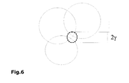
- the initial donut evolves into two peaks, one centered on the AP and the other in its symmetrical position ( Fig. 4.b-c ). After a corner, only the correct peak survives, that is further sharpened by subsequent RSS measurements ( Fig. 4.d-f ).
- the complete map is thus a mixture of N H 'donuts' products, in which the coefficients, that are the probabilities for h h (last term in eq. (7)), also evolve over time. This applies also directly to the TOA measurement case and in a modified form to the TDOA case, where the peaks are where hyperbola shaped donuts intersect (instead of circular donuts).
- the RSS (and/or TOA / TDOA) contribution is a further multiplicative factor (or additive when working with logarithmic representations which can be an advantage for numerical stability or computational performance reasons as is well known when applying probabilistic algorithms) in the particle weights w k i ⁇ w k - 1 i ⁇ I M i ⁇ I W i , where I M i is relative to the Map M estimation [7,eq.(4)] and I W i is a sufficient numerical approximation for I w in eq. (5).
- the problem with I w is that the integrand function in eq. (5) is nonparametric in nature.
- An advantageous solution is to sample it over a static or dynamic grid of X AP values in the area of interest. The next section describes a computationally more inexpensive solution to this sampling.
- the initialization step reproduced in the scheme of Fig. 5 is triggered according to a suitable rule. For example, one could introduce a static or dynamic number of RSS measurements T ( T ⁇ 1) from a new AP, required for triggering the initialization step. Its goal is to build the approximated WiFi map W in eq. (6) given the collected RSS and the path assumed by each particle.
- the h distribution should be assigned between the proposed N H values and one of the possible choices, useful when no prior information is available about the APs, is to use a uniform distribution.
- the x AP PDF instead, is given by the GMM in eq. (11).
- the main problem is to find the GMM parameters, i.e. to estimate peaks' positions and parameters, preferably, only employing the sequence of measurements and poses. To this task, the steps described in Algorithm 1 and sketched in Fig. 5 are advantageously applied.
- ⁇ p,h,k-1 and S p.h.k-1 be mean and covariance matrix respectively of the p-th peak for the reference power h and ⁇ p.h.k -1 its coefficient in the GMM at the instant k-1.
- r k and ⁇ G.k be the parameters related to the new RSS likelihood computed preferably as in eqs. (12) - (13) respectively.
- An advantageous way of computing the new peak's parameters follows accordingly to the procedure in Fig.7 , and described henceforth. Both the translation and the rotation of the reference system are not necessary but are advantageous in a practical implementation because they allow easier computation (an equivalent procedure can be straightforwardly obtained avoiding the translation and rotation by applying simple geometric transformations to the expressions):
- N H is set to 1 and equation (12) is replaced by a suitable likelihood function (e.g. Gaussian over ⁇ k parametrised on the time delay by taking into account the speed of light (for the mean of ⁇ k ) and its variance or spread depending on the time delay measurement uncertainty of the radio time delay processing unit.
- a suitable likelihood function e.g. Gaussian over ⁇ k parametrised on the time delay by taking into account the speed of light (for the mean of ⁇ k ) and its variance or spread depending on the time delay measurement uncertainty of the radio time delay processing unit.
- N H is to 1.
- the building map is very accurate except for the part indicated by an empty black rectangle (the room on the right was actually entered).
- the WiFi Map the actual position of the APs are shown as squares and their estimations are shown as circles: the former AP is positioned with great accuracy, while the latter one shows an error limited to few meters.
Landscapes
- Engineering & Computer Science (AREA)
- Radar, Positioning & Navigation (AREA)
- Remote Sensing (AREA)
- Physics & Mathematics (AREA)
- General Physics & Mathematics (AREA)
- Automation & Control Theory (AREA)
- Aviation & Aerospace Engineering (AREA)
- Computer Networks & Wireless Communication (AREA)
- Signal Processing (AREA)
- Probability & Statistics with Applications (AREA)
- Navigation (AREA)
- Position Fixing By Use Of Radio Waves (AREA)
Priority Applications (4)
| Application Number | Priority Date | Filing Date | Title |
|---|---|---|---|
| EP12157532A EP2570772A1 (fr) | 2011-09-16 | 2012-02-29 | Procédé pour la localisation et la cartographie de piétons ou de robots au moyen de points d'accès sans fil |
| PCT/EP2012/068233 WO2013038005A1 (fr) | 2011-09-16 | 2012-09-17 | Procédé de localisation et de cartographie de piétons ou de robots au moyen de points d'accès sans fil |
| EP12759714.4A EP2756263B1 (fr) | 2011-09-16 | 2012-09-17 | Procédé pour la localisation et la cartographie de piétons ou de robots au moyen de points d'accès sans fil |
| US14/345,284 US20150031390A1 (en) | 2011-09-16 | 2012-09-17 | Method for localisation and mapping of pedestrians or robots using wireless access points |
Applications Claiming Priority (2)
| Application Number | Priority Date | Filing Date | Title |
|---|---|---|---|
| EP11181571 | 2011-09-16 | ||
| EP12157532A EP2570772A1 (fr) | 2011-09-16 | 2012-02-29 | Procédé pour la localisation et la cartographie de piétons ou de robots au moyen de points d'accès sans fil |
Publications (1)
| Publication Number | Publication Date |
|---|---|
| EP2570772A1 true EP2570772A1 (fr) | 2013-03-20 |
Family
ID=45755297
Family Applications (2)
| Application Number | Title | Priority Date | Filing Date |
|---|---|---|---|
| EP12157532A Withdrawn EP2570772A1 (fr) | 2011-09-16 | 2012-02-29 | Procédé pour la localisation et la cartographie de piétons ou de robots au moyen de points d'accès sans fil |
| EP12759714.4A Active EP2756263B1 (fr) | 2011-09-16 | 2012-09-17 | Procédé pour la localisation et la cartographie de piétons ou de robots au moyen de points d'accès sans fil |
Family Applications After (1)
| Application Number | Title | Priority Date | Filing Date |
|---|---|---|---|
| EP12759714.4A Active EP2756263B1 (fr) | 2011-09-16 | 2012-09-17 | Procédé pour la localisation et la cartographie de piétons ou de robots au moyen de points d'accès sans fil |
Country Status (3)
| Country | Link |
|---|---|
| US (1) | US20150031390A1 (fr) |
| EP (2) | EP2570772A1 (fr) |
| WO (1) | WO2013038005A1 (fr) |
Cited By (33)
| Publication number | Priority date | Publication date | Assignee | Title |
|---|---|---|---|---|
| CN103278154A (zh) * | 2013-05-10 | 2013-09-04 | 杭州电子科技大学 | 火灾逃生导航系统 |
| CN103308047A (zh) * | 2013-05-10 | 2013-09-18 | 杭州师范大学 | 一种具有人工在线修正功能的移动机器人定位方法 |
| CN103389094A (zh) * | 2013-07-15 | 2013-11-13 | 哈尔滨工程大学 | 一种改进的粒子滤波方法 |
| US20140365127A1 (en) * | 2013-06-11 | 2014-12-11 | Qualcomm Incorporated | Modeling Characteristics of a Venue |
| WO2015003684A1 (fr) * | 2013-07-09 | 2015-01-15 | Deutsches Zentrum für Luft- und Raumfahrt e.V. | Détermination d'une position d'un récepteur mobile |
| CN105159301A (zh) * | 2015-09-22 | 2015-12-16 | 深圳先进技术研究院 | 一种基于扫地机器人的wifi中继系统及方法 |
| CN105204505A (zh) * | 2015-09-22 | 2015-12-30 | 深圳先进技术研究院 | 一种基于扫地机器人定位视频采集和制图的系统及方法 |
| CN105554706A (zh) * | 2015-05-04 | 2016-05-04 | 四川大学 | 基于多网络融合的室内定位方案 |
| CN105739506A (zh) * | 2016-04-26 | 2016-07-06 | 昆山易捷联控制系统研发科技有限公司 | 智能运载机器人的自主导航方法 |
| CN106101621A (zh) * | 2016-06-23 | 2016-11-09 | 深圳先进技术研究院 | 一种基于导航机器人的室内街景绘制系统及方法 |
| CN106123892A (zh) * | 2016-06-22 | 2016-11-16 | 武汉科技大学 | 一种基于无线传感器网络与地磁地图的机器人定位方法 |
| US9510318B2 (en) | 2013-06-27 | 2016-11-29 | Google Technology Holdings LLC | Method and apparatus for ascertaining a location of a personal portable wireless communication device |
| EP3165877A1 (fr) * | 2015-11-04 | 2017-05-10 | Tata Consultancy Services Limited | Systèmes et procédés de fusion de données de capteur inertiel et bluetooth à faible énergie pour la localisation |
| CN106790468A (zh) * | 2016-12-10 | 2017-05-31 | 武汉白虹软件科技有限公司 | 一种分析用户WiFi活动轨迹规律的分布式实现方法 |
| EP3085144A4 (fr) * | 2013-12-17 | 2017-08-02 | Qualcomm Incorporated | Procédés et systèmes de localisation d'articles et de détermination de localisations d'articles |
| CN108120438A (zh) * | 2017-12-15 | 2018-06-05 | 北京工商大学 | 一种基于imu和rfid信息融合的室内目标快速跟踪方法 |
| CN108279687A (zh) * | 2018-03-28 | 2018-07-13 | 西北农林科技大学 | 一种郁闭果园履带拖拉机组合导航系统 |
| CN108303090A (zh) * | 2017-12-26 | 2018-07-20 | 武汉创驰蓝天信息科技有限公司 | 基于人工智能的室内指纹定位方法及系统 |
| CN108594170A (zh) * | 2018-04-04 | 2018-09-28 | 合肥工业大学 | 一种基于卷积神经网络识别技术的wifi室内定位方法 |
| CN108646749A (zh) * | 2018-06-07 | 2018-10-12 | 杭州晶智能科技有限公司 | 基于无线网络和地磁信号的室内移动机器人环境地图建立方法 |
| CN109115209A (zh) * | 2018-07-20 | 2019-01-01 | 湖南格纳微信息科技有限公司 | 一种管廊内人员定位方法及装置 |
| CN109141437A (zh) * | 2018-09-30 | 2019-01-04 | 中国科学院合肥物质科学研究院 | 一种机器人全局重定位方法 |
| CN109298389A (zh) * | 2018-08-29 | 2019-02-01 | 东南大学 | 基于多粒子群优化的室内行人组合位姿估计方法 |
| WO2019136019A1 (fr) | 2018-01-05 | 2019-07-11 | Irobot Corporation | Mappage, commande et affichage de dispositifs en réseau avec un robot de nettoyage mobile |
| EP3531069A1 (fr) * | 2018-02-23 | 2019-08-28 | Tata Consultancy Services Limited | Planification de chemin basée sur un contexte pour une navigation de vecteur dans des cartes spatiales hexagonales |
| CN110309693A (zh) * | 2018-03-27 | 2019-10-08 | 纬创资通股份有限公司 | 多层次状态侦测系统与方法 |
| CN110308419A (zh) * | 2019-06-27 | 2019-10-08 | 南京大学 | 一种基于静态求解和粒子滤波的鲁棒tdoa定位方法 |
| CN111033423A (zh) * | 2018-04-18 | 2020-04-17 | 百度时代网络技术(北京)有限公司 | 用于评估自动驾驶车辆的定位系统的方法 |
| CN112904369A (zh) * | 2021-01-14 | 2021-06-04 | 深圳市杉川致行科技有限公司 | 机器人重定位方法、装置、机器人和计算机可读存储介质 |
| CN113566820A (zh) * | 2021-06-17 | 2021-10-29 | 电子科技大学 | 一种基于位置指纹和pdr算法的融合人行定位方法 |
| CN113703443A (zh) * | 2021-08-12 | 2021-11-26 | 北京科技大学 | 一种不依赖gnss的无人车自主定位与环境探索方法 |
| CN114928882A (zh) * | 2022-04-24 | 2022-08-19 | 湖南大学 | 基于自适应贝叶斯综合学习粒子群优化的wlan指纹定位方法 |
| US11885900B2 (en) | 2019-01-10 | 2024-01-30 | Technische Universität München | Method and system for tracking a mobile device |
Families Citing this family (42)
| Publication number | Priority date | Publication date | Assignee | Title |
|---|---|---|---|---|
| US9395190B1 (en) | 2007-05-31 | 2016-07-19 | Trx Systems, Inc. | Crowd sourced mapping with robust structural features |
| US11156464B2 (en) | 2013-03-14 | 2021-10-26 | Trx Systems, Inc. | Crowd sourced mapping with robust structural features |
| US11268818B2 (en) | 2013-03-14 | 2022-03-08 | Trx Systems, Inc. | Crowd sourced mapping with robust structural features |
| WO2015126499A2 (fr) | 2013-12-02 | 2015-08-27 | Andrew Irish | Systèmes et procédés pour la localisation et la cartographie 3d probabilistes utilisant le snr gnss |
| US9380425B2 (en) | 2013-12-05 | 2016-06-28 | At&T Mobility Ii Llc | Systems, methods, and computer-readable storage devices for generating and using a radio-frequency map of an area |
| US9739626B2 (en) * | 2014-03-31 | 2017-08-22 | Amadeus S.A.S. | Journey planning method and system |
| US9759561B2 (en) * | 2015-01-06 | 2017-09-12 | Trx Systems, Inc. | Heading constraints in a particle filter |
| WO2016195527A1 (fr) * | 2015-06-05 | 2016-12-08 | Общество с ограниченной ответственностью "Навигационные решения" | Procédé et système de navigation dans un local |
| BR112018000846A2 (pt) | 2015-07-17 | 2018-09-04 | Univ California | ?método para determinar localização de dispositivo de usuário? |
| KR101751731B1 (ko) * | 2015-08-10 | 2017-06-29 | 숭실대학교산학협력단 | 위치 추적 시스템 및 방법 |
| US10386493B2 (en) | 2015-10-01 | 2019-08-20 | The Regents Of The University Of California | System and method for localization and tracking |
| CN106814706B (zh) * | 2015-11-27 | 2019-03-12 | 梅特勒-托利多(常州)测量技术有限公司 | 包装、灌装及配料控制过程的滤波方式最优设定方法 |
| WO2017199274A1 (fr) | 2016-05-19 | 2017-11-23 | Nec Corporation | Appareil de traitement d'informations, station de base, procédé de traitement d'informations et programme |
| US9661473B1 (en) | 2016-06-17 | 2017-05-23 | Qualcomm Incorporated | Methods and apparatus for determining locations of devices in confined spaces |
| US9820100B1 (en) | 2016-06-17 | 2017-11-14 | Qualcomm Incorporated | Multi-source positioning |
| CN106255069B (zh) * | 2016-08-03 | 2019-11-08 | 深圳市数字城市工程研究中心 | 一种人口空间分布的模拟方法及装置 |
| US10075818B2 (en) * | 2016-09-13 | 2018-09-11 | Google Llc | Systems and methods for graph-based localization and mapping |
| CN106650529B (zh) * | 2016-10-12 | 2019-07-05 | 广东技术师范学院 | 一种制造物联网rfid读写器节点部署优化方法 |
| US10429190B2 (en) * | 2016-11-08 | 2019-10-01 | Ford Global Technologies, Llc | Vehicle localization based on wireless local area network nodes |
| US10925029B2 (en) * | 2016-12-22 | 2021-02-16 | Huawei Technologies Co., Ltd. | Wi-Fi access point-based positioning method and device |
| US10694325B2 (en) | 2016-12-31 | 2020-06-23 | Google Llc | Determining position of a device in three-dimensional space and corresponding calibration techniques |
| US10761541B2 (en) * | 2017-04-21 | 2020-09-01 | X Development Llc | Localization with negative mapping |
| US10664502B2 (en) * | 2017-05-05 | 2020-05-26 | Irobot Corporation | Methods, systems, and devices for mapping wireless communication signals for mobile robot guidance |
| US11493930B2 (en) | 2018-09-28 | 2022-11-08 | Intrinsic Innovation Llc | Determining changes in marker setups for robot localization |
| US11071047B2 (en) * | 2018-06-22 | 2021-07-20 | Huawei Technologies Co., Ltd. | Systems and methods for reduced network signalling based on mapping |
| US10694485B2 (en) * | 2018-08-15 | 2020-06-23 | GM Global Technology Operations LLC | Method and apparatus for correcting multipath offset and determining wireless station locations |
| US10852740B2 (en) | 2018-09-28 | 2020-12-01 | X Development Llc | Determining the orientation of flat reflectors during robot mapping |
| US10824160B2 (en) | 2018-09-28 | 2020-11-03 | X Development Llc | Robot localization with co-located markers |
| CN111561921B (zh) * | 2019-02-14 | 2022-05-10 | 华为技术有限公司 | 定位方法及装置 |
| CN109581285A (zh) * | 2018-12-13 | 2019-04-05 | 成都普连众通科技有限公司 | 一种基于运动行为离散数据滤波的指纹定位算法 |
| CN110095788A (zh) * | 2019-05-29 | 2019-08-06 | 电子科技大学 | 一种基于灰狼优化算法的rbpf-slam改进方法 |
| US11290850B2 (en) * | 2019-06-05 | 2022-03-29 | Research & Business Foundation Sungkyunkwan University | Methods and apparatuses for indoor positioning using particle filter based on intensity of radio signal |
| US11343244B2 (en) | 2019-08-02 | 2022-05-24 | Dell Products, Lp | Method and apparatus for multi-factor verification of a computing device location within a preset geographic area |
| US11197262B2 (en) | 2019-08-02 | 2021-12-07 | Dell Products, Lp | Systems and methods of room profiling using wireless local area networks |
| US11330551B2 (en) | 2019-08-12 | 2022-05-10 | Dell Products, Lp | Method and apparatus for location aware optimal wireless link selection system |
| US11409881B2 (en) | 2019-08-12 | 2022-08-09 | Dell Products, Lp | Method and apparatus for wireless signal based location security system |
| US11510047B2 (en) | 2019-08-12 | 2022-11-22 | Dell Products, Lp | Learning based wireless performance adjustment for mobile information handling system |
| CN111324116B (zh) * | 2020-02-14 | 2021-09-21 | 南京航空航天大学 | 基于粒子滤波的机器人定位方法 |
| US11438886B2 (en) * | 2020-02-27 | 2022-09-06 | Psj International Ltd. | System for establishing positioning map data and method for the same |
| CN111586562A (zh) * | 2020-05-07 | 2020-08-25 | 惠州学院 | 一种基于rfid的离散制造三维定位方法 |
| CN114245309A (zh) * | 2020-09-09 | 2022-03-25 | 阿里巴巴集团控股有限公司 | 定位方法、装置、设备及存储介质 |
| CN115980804B (zh) * | 2023-03-20 | 2023-08-22 | 中国铁塔股份有限公司 | 一种室内定位方法及装置 |
Citations (2)
| Publication number | Priority date | Publication date | Assignee | Title |
|---|---|---|---|---|
| US20090054076A1 (en) * | 2005-05-31 | 2009-02-26 | Frederic Evennou | Method and Device for Locating a Terminal in a Wireless Local Area Network |
| WO2011033100A1 (fr) | 2009-09-18 | 2011-03-24 | Deutsches Zentrum Fuer Luft- Und Raumfahrt E.V. | Procédé d'établissement d'une carte relative à des informations de localisation sur la probabilité du déplacement futur d'une personne |
Family Cites Families (5)
| Publication number | Priority date | Publication date | Assignee | Title |
|---|---|---|---|---|
| US20050246092A1 (en) * | 2004-04-30 | 2005-11-03 | Richard Moscatiello | Wireless mobile asset tracking vehicle |
| EP2409172B1 (fr) * | 2009-03-19 | 2016-02-10 | Cork Institute Of Technology | Système de localisation et de suivi |
| US8423063B2 (en) * | 2010-01-11 | 2013-04-16 | Samuel M. Premutico | Guided remote storage system |
| CA2769788C (fr) * | 2011-03-23 | 2019-08-13 | Trusted Positioning Inc. | Procedes d'estimation de l'attitude et des ecarts d'alignement pour une navigation portative sans contraintes |
| US8868106B2 (en) * | 2012-02-29 | 2014-10-21 | Aeris Communications, Inc. | System and method for large-scale and near-real-time search of mobile device locations in arbitrary geographical boundaries |
-
2012
- 2012-02-29 EP EP12157532A patent/EP2570772A1/fr not_active Withdrawn
- 2012-09-17 EP EP12759714.4A patent/EP2756263B1/fr active Active
- 2012-09-17 US US14/345,284 patent/US20150031390A1/en not_active Abandoned
- 2012-09-17 WO PCT/EP2012/068233 patent/WO2013038005A1/fr active Application Filing
Patent Citations (2)
| Publication number | Priority date | Publication date | Assignee | Title |
|---|---|---|---|---|
| US20090054076A1 (en) * | 2005-05-31 | 2009-02-26 | Frederic Evennou | Method and Device for Locating a Terminal in a Wireless Local Area Network |
| WO2011033100A1 (fr) | 2009-09-18 | 2011-03-24 | Deutsches Zentrum Fuer Luft- Und Raumfahrt E.V. | Procédé d'établissement d'une carte relative à des informations de localisation sur la probabilité du déplacement futur d'une personne |
Non-Patent Citations (18)
| Title |
|---|
| 0, WOODMAN; R. HARLE: "Proc. of the 10th Int. Conf. on Ubiquitous computing, UbiComp '08", 2008, ACM, article "Pedestrian localisation for indoor environments", pages: 114 - 123 |
| B, KRACH; P. ROBERSTON: "Cascaded estimation architecture for integration of foot- mounted inertial sensors", POSITION, LOCATION AND NAVIGATION SYMPOSIUM, 2008 IEEE/ION, May 2008 (2008-05-01), pages 112 - 119 |
| B. FERRIS; D. FOX; N. LAWRENCE: "Wifi-slam using gaussian process latent variable models", IN PROC. OF IJCAI 2007, 2007, pages 2480 - 2485 |
| E, FOXLIN.: "Pedestrian tracking with shoe-mounted inertial sensors", IEEE COMPUTER GRAPHICS AND APPLICATIONS, vol. 25, no. 6, November 2005 (2005-11-01), pages 38 - 46 |
| E. MENEGATTI; A. ZANELLA; S. ZILLI; F. ZORZI; E. PAGELLO: "Range-only slam with a mobile robot and a wireless sensor networks", ROBOT. AND AUTOM., 2009. ICRA '09. IEEE INT. CONF. ON, 8 May 2009 (2009-05-08), pages 8 - 14 |
| H. DURRANT-WHYTE; T. BAILEY: "Simultaneous localization and mapping: part i.", IEEE ROBOT. AUTOM. MAG., vol. 13, no. 2, June 2006 (2006-06-01), pages 99 - 110 |
| J. HUANG; D. MILLMAN; M. QUIGLEY; D, STEVENS; S. THRUN; A. AGGARWAL.: "Efficient, Generalized Indoor WiFi GraphSLAM", PROC. OF ICRA, 2011 |
| L. BRUNO; P. ROBERTSON: "WiSLAM: improving FootSLAM with W!Fi. To appear in Guimaraes, Portugal", IPIN, September 2011 (2011-09-01) |
| LUIGI BRUNO ET AL: "WiSLAM: Improving FootSLAM with WiFi", INDOOR POSITIONING AND INDOOR NAVIGATION (IPIN), 2011 INTERNATIONAL CONFERENCE ON, IEEE, 21 September 2011 (2011-09-21), pages 1 - 10, XP031990131, ISBN: 978-1-4577-1805-2, DOI: 10.1109/IPIN.2011.6071916 * |
| M. YOUSSEF; A. AGRAWALA: "The horus location determination system", WIRELESS NETWORKS, vol. 14, 2008, pages 357 - 374 |
| M.S. ARULAMPALAM; S. MASKELL; N. GORDON; T. CLAPP.: "A tutorial on particle filters for online nonlinear/non-gaussian bayesian tracking", IEEE TRANS. SIGNAL PROCESS., vol. 50, no. 2, February 2002 (2002-02-01), pages 174 - 188 |
| P. ADDESSO; L. BRUNO; R. RESTAINO: "Integrating RSS from unknown access points in WLAN positioning", IWCMC, July 2011 (2011-07-01) |
| P. BAHL; V. PADMANABHAN.: "Radar: An in-building rf-based user location and tracking system", PROC. OF IEEE INFOCOM 2000, March 2000 (2000-03-01), pages 775 - 784 |
| P. ROBERSTON; M. GARCIA PUYOL; M. ANGERMANN.: "Collaborative pedestrian mapping of buildings using inertial sensors and footslam", ION, September 2011 (2011-09-01) |
| P. ROBERTSON; M. ANGERMANN; B. KRACH: "Proc. of the 11th Int. Conf. on Ubiquitous computing, Ubicomp '09", 2009, ACM, article "Simultaneous localization and mapping for pedestrians using only foot-mounted inertial sensors", pages: 93 - 96 |
| P. ROBERTSON; M. ANGERMANN; M. KHIDER.: "Improving simultaneous localization and mapping for pedestrian navigation and automatic mapping of buildings by using online human-based feature labeling", POSITION LOCATION AND NAVIGATION SYMPOSIUM (PLANS), 2010 IEEE/ION, May 2010 (2010-05-01), pages 365 - 374 |
| R. BATTITI; R, BRUNATO.: "Statistical learning theory for location fingerprinting in wireless lans", COMPUTER NETWORKS, vol. 47, no. 6, April 2005 (2005-04-01) |
| S. BEAUREGARD, WIDYAWAN; M. KLEPAL.: "Indoor pdr performance enhancement using minimal map information and particle filters", POSITION, LOCATION AND NAVIGATION SYMPOSIUM, 2008 IEEE/ION, May 2008 (2008-05-01), pages 141 - 147 |
Cited By (53)
| Publication number | Priority date | Publication date | Assignee | Title |
|---|---|---|---|---|
| CN103278154B (zh) * | 2013-05-10 | 2016-03-30 | 杭州电子科技大学 | 火灾逃生导航系统 |
| CN103308047A (zh) * | 2013-05-10 | 2013-09-18 | 杭州师范大学 | 一种具有人工在线修正功能的移动机器人定位方法 |
| CN103278154A (zh) * | 2013-05-10 | 2013-09-04 | 杭州电子科技大学 | 火灾逃生导航系统 |
| CN103308047B (zh) * | 2013-05-10 | 2016-04-20 | 杭州师范大学 | 一种具有人工在线修正功能的移动机器人定位方法 |
| US20140365127A1 (en) * | 2013-06-11 | 2014-12-11 | Qualcomm Incorporated | Modeling Characteristics of a Venue |
| US9115997B2 (en) * | 2013-06-11 | 2015-08-25 | Qualcomm Incorporated | Modeling characteristics of a venue |
| US9510318B2 (en) | 2013-06-27 | 2016-11-29 | Google Technology Holdings LLC | Method and apparatus for ascertaining a location of a personal portable wireless communication device |
| WO2015003684A1 (fr) * | 2013-07-09 | 2015-01-15 | Deutsches Zentrum für Luft- und Raumfahrt e.V. | Détermination d'une position d'un récepteur mobile |
| US10175339B2 (en) | 2013-07-09 | 2019-01-08 | DEUTSCHES ZENTRUM FüR LUFT-UND RAUMFAHRT E.V. | Determining a position of a mobile receiver |
| CN103389094A (zh) * | 2013-07-15 | 2013-11-13 | 哈尔滨工程大学 | 一种改进的粒子滤波方法 |
| CN103389094B (zh) * | 2013-07-15 | 2017-03-01 | 哈尔滨工程大学 | 一种改进的粒子滤波方法 |
| EP3085144A4 (fr) * | 2013-12-17 | 2017-08-02 | Qualcomm Incorporated | Procédés et systèmes de localisation d'articles et de détermination de localisations d'articles |
| CN105554706A (zh) * | 2015-05-04 | 2016-05-04 | 四川大学 | 基于多网络融合的室内定位方案 |
| CN105554706B (zh) * | 2015-05-04 | 2019-06-11 | 四川大学 | 基于多网络融合的室内定位方案 |
| CN105204505A (zh) * | 2015-09-22 | 2015-12-30 | 深圳先进技术研究院 | 一种基于扫地机器人定位视频采集和制图的系统及方法 |
| CN105159301A (zh) * | 2015-09-22 | 2015-12-16 | 深圳先进技术研究院 | 一种基于扫地机器人的wifi中继系统及方法 |
| EP3165877A1 (fr) * | 2015-11-04 | 2017-05-10 | Tata Consultancy Services Limited | Systèmes et procédés de fusion de données de capteur inertiel et bluetooth à faible énergie pour la localisation |
| CN105739506A (zh) * | 2016-04-26 | 2016-07-06 | 昆山易捷联控制系统研发科技有限公司 | 智能运载机器人的自主导航方法 |
| CN106123892A (zh) * | 2016-06-22 | 2016-11-16 | 武汉科技大学 | 一种基于无线传感器网络与地磁地图的机器人定位方法 |
| CN106101621A (zh) * | 2016-06-23 | 2016-11-09 | 深圳先进技术研究院 | 一种基于导航机器人的室内街景绘制系统及方法 |
| CN106790468B (zh) * | 2016-12-10 | 2020-06-02 | 武汉白虹软件科技有限公司 | 一种分析用户WiFi活动轨迹规律的分布式实现方法 |
| CN106790468A (zh) * | 2016-12-10 | 2017-05-31 | 武汉白虹软件科技有限公司 | 一种分析用户WiFi活动轨迹规律的分布式实现方法 |
| CN108120438A (zh) * | 2017-12-15 | 2018-06-05 | 北京工商大学 | 一种基于imu和rfid信息融合的室内目标快速跟踪方法 |
| CN108303090A (zh) * | 2017-12-26 | 2018-07-20 | 武汉创驰蓝天信息科技有限公司 | 基于人工智能的室内指纹定位方法及系统 |
| EP3735340A4 (fr) * | 2018-01-05 | 2022-01-19 | iRobot Corporation | Mappage, commande et affichage de dispositifs en réseau avec un robot de nettoyage mobile |
| US11556125B2 (en) | 2018-01-05 | 2023-01-17 | Irobot Corporation | Mapping, controlling, and displaying networked devices with a mobile cleaning robot |
| CN111526973B (zh) * | 2018-01-05 | 2023-10-20 | 艾罗伯特公司 | 用移动清洁机器人映射、控制和显示网络设备 |
| WO2019136019A1 (fr) | 2018-01-05 | 2019-07-11 | Irobot Corporation | Mappage, commande et affichage de dispositifs en réseau avec un robot de nettoyage mobile |
| CN111526973A (zh) * | 2018-01-05 | 2020-08-11 | 艾罗伯特公司 | 用移动清洁机器人映射、控制和显示网络设备 |
| EP3531069A1 (fr) * | 2018-02-23 | 2019-08-28 | Tata Consultancy Services Limited | Planification de chemin basée sur un contexte pour une navigation de vecteur dans des cartes spatiales hexagonales |
| CN110309693B (zh) * | 2018-03-27 | 2021-06-11 | 纬创资通股份有限公司 | 多层次状态侦测系统与方法 |
| CN110309693A (zh) * | 2018-03-27 | 2019-10-08 | 纬创资通股份有限公司 | 多层次状态侦测系统与方法 |
| CN108279687A (zh) * | 2018-03-28 | 2018-07-13 | 西北农林科技大学 | 一种郁闭果园履带拖拉机组合导航系统 |
| CN108594170B (zh) * | 2018-04-04 | 2021-09-14 | 合肥工业大学 | 一种基于卷积神经网络识别技术的wifi室内定位方法 |
| CN108594170A (zh) * | 2018-04-04 | 2018-09-28 | 合肥工业大学 | 一种基于卷积神经网络识别技术的wifi室内定位方法 |
| CN111033423B (zh) * | 2018-04-18 | 2023-11-21 | 百度时代网络技术(北京)有限公司 | 用于评估自动驾驶车辆的定位系统的方法 |
| CN111033423A (zh) * | 2018-04-18 | 2020-04-17 | 百度时代网络技术(北京)有限公司 | 用于评估自动驾驶车辆的定位系统的方法 |
| CN108646749A (zh) * | 2018-06-07 | 2018-10-12 | 杭州晶智能科技有限公司 | 基于无线网络和地磁信号的室内移动机器人环境地图建立方法 |
| CN109115209A (zh) * | 2018-07-20 | 2019-01-01 | 湖南格纳微信息科技有限公司 | 一种管廊内人员定位方法及装置 |
| CN109115209B (zh) * | 2018-07-20 | 2022-03-11 | 湖南格纳微信息科技有限公司 | 一种管廊内人员定位方法及装置 |
| CN109298389B (zh) * | 2018-08-29 | 2022-09-23 | 东南大学 | 基于多粒子群优化的室内行人组合位姿估计方法 |
| CN109298389A (zh) * | 2018-08-29 | 2019-02-01 | 东南大学 | 基于多粒子群优化的室内行人组合位姿估计方法 |
| CN109141437B (zh) * | 2018-09-30 | 2021-11-26 | 中国科学院合肥物质科学研究院 | 一种机器人全局重定位方法 |
| CN109141437A (zh) * | 2018-09-30 | 2019-01-04 | 中国科学院合肥物质科学研究院 | 一种机器人全局重定位方法 |
| US11885900B2 (en) | 2019-01-10 | 2024-01-30 | Technische Universität München | Method and system for tracking a mobile device |
| CN110308419B (zh) * | 2019-06-27 | 2021-04-06 | 南京大学 | 一种基于静态求解和粒子滤波的鲁棒tdoa定位方法 |
| CN110308419A (zh) * | 2019-06-27 | 2019-10-08 | 南京大学 | 一种基于静态求解和粒子滤波的鲁棒tdoa定位方法 |
| CN112904369A (zh) * | 2021-01-14 | 2021-06-04 | 深圳市杉川致行科技有限公司 | 机器人重定位方法、装置、机器人和计算机可读存储介质 |
| CN112904369B (zh) * | 2021-01-14 | 2024-03-19 | 深圳市杉川致行科技有限公司 | 机器人重定位方法、装置、机器人和计算机可读存储介质 |
| CN113566820A (zh) * | 2021-06-17 | 2021-10-29 | 电子科技大学 | 一种基于位置指纹和pdr算法的融合人行定位方法 |
| CN113703443A (zh) * | 2021-08-12 | 2021-11-26 | 北京科技大学 | 一种不依赖gnss的无人车自主定位与环境探索方法 |
| CN113703443B (zh) * | 2021-08-12 | 2023-10-13 | 北京科技大学 | 一种不依赖gnss的无人车自主定位与环境探索方法 |
| CN114928882A (zh) * | 2022-04-24 | 2022-08-19 | 湖南大学 | 基于自适应贝叶斯综合学习粒子群优化的wlan指纹定位方法 |
Also Published As
| Publication number | Publication date |
|---|---|
| EP2756263A1 (fr) | 2014-07-23 |
| WO2013038005A1 (fr) | 2013-03-21 |
| EP2756263B1 (fr) | 2018-04-11 |
| US20150031390A1 (en) | 2015-01-29 |
Similar Documents
| Publication | Publication Date | Title |
|---|---|---|
| EP2756263B1 (fr) | Procédé pour la localisation et la cartographie de piétons ou de robots au moyen de points d'accès sans fil | |
| Bruno et al. | Wislam: Improving footslam with wifi | |
| EP3275254B1 (fr) | Système et procédé d'intérieur localisation utilisant balises | |
| US20200064446A1 (en) | Cooperative target tracking and signal propagation learning using mobile sensors | |
| US8279840B2 (en) | Systems and methods for providing location based services (LBS) utilizing WLAN and/or GPS signals for seamless indoor and outdoor tracking | |
| Bekkali et al. | RFID indoor positioning based on probabilistic RFID map and Kalman filtering | |
| EP3108706B1 (fr) | Localisation d'un dispositif d'équipement d'utilisateur sans fil dans une zone cible | |
| Seshadri et al. | A bayesian sampling approach to in-door localization of wireless devices using received signal strength indication | |
| Shin et al. | Wi-Fi fingerprint-based topological map building for indoor user tracking | |
| Faragher et al. | Towards an efficient, intelligent, opportunistic smartphone indoor positioning system | |
| Ibrahim et al. | Wi-go: accurate and scalable vehicle positioning using wifi fine timing measurement | |
| Konings et al. | SpringLoc: A device-free localization technique for indoor positioning and tracking using adaptive RSSI spring relaxation | |
| Aykaç et al. | ZigBee-based indoor localization system with the personal dynamic positioning method and modified particle filter estimation | |
| Dashti et al. | Rssi localization with gaussian processes and tracking | |
| Miyagusuku et al. | Precise and accurate wireless signal strength mappings using Gaussian processes and path loss models | |
| Alshami et al. | Automatic WLAN fingerprint radio map generation for accurate indoor positioning based on signal path loss model | |
| Kuai et al. | Simultaneous localization and mapping (SLAM) for indoor autonomous mobile robot navigation in wireless sensor networks | |
| Martins et al. | Improving bluetooth beacon-based indoor location and fingerprinting | |
| Khan et al. | Experimental testbed evaluation of cell level indoor localization algorithm using Wi-Fi and LoRa protocols | |
| İlçi et al. | An investigation of different Wi-Fi signal behaviours and their effects on indoor positioning accuracy | |
| Hotta et al. | A robust room-level localization method based on transition probability for indoor environments | |
| Inoue et al. | Indoor positioning system using beacon devices for practical pedestrian navigation on mobile phone | |
| Zdruba et al. | Monte Carlo sampling based in-home location tracking with minimal RF infrastructure requirements | |
| US20210212015A1 (en) | Methods for improving source localization based on time-of-arrival measurements | |
| Patel et al. | Fusing map information with a probabilistic sensor model for indoor localization using RF beacons |
Legal Events
| Date | Code | Title | Description |
|---|---|---|---|
| PUAI | Public reference made under article 153(3) epc to a published international application that has entered the european phase |
Free format text: ORIGINAL CODE: 0009012 |
|
| AK | Designated contracting states |
Kind code of ref document: A1 Designated state(s): AL AT BE BG CH CY CZ DE DK EE ES FI FR GB GR HR HU IE IS IT LI LT LU LV MC MK MT NL NO PL PT RO RS SE SI SK SM TR |
|
| AX | Request for extension of the european patent |
Extension state: BA ME |
|
| STAA | Information on the status of an ep patent application or granted ep patent |
Free format text: STATUS: THE APPLICATION IS DEEMED TO BE WITHDRAWN |
|
| 18D | Application deemed to be withdrawn |
Effective date: 20130921 |