EP2503510A1 - Mise en correspondance des caractéristiques sous large base stéréo utilisant une navigation collaborative et contrainte par des données numériques d'élévation de terrain - Google Patents
Mise en correspondance des caractéristiques sous large base stéréo utilisant une navigation collaborative et contrainte par des données numériques d'élévation de terrain Download PDFInfo
- Publication number
- EP2503510A1 EP2503510A1 EP12160019A EP12160019A EP2503510A1 EP 2503510 A1 EP2503510 A1 EP 2503510A1 EP 12160019 A EP12160019 A EP 12160019A EP 12160019 A EP12160019 A EP 12160019A EP 2503510 A1 EP2503510 A1 EP 2503510A1
- Authority
- EP
- European Patent Office
- Prior art keywords
- feature
- platform
- features
- zone
- dted
- Prior art date
- Legal status (The legal status is an assumption and is not a legal conclusion. Google has not performed a legal analysis and makes no representation as to the accuracy of the status listed.)
- Granted
Links
Images


Classifications
-
- G—PHYSICS
- G06—COMPUTING OR CALCULATING; COUNTING
- G06T—IMAGE DATA PROCESSING OR GENERATION, IN GENERAL
- G06T7/00—Image analysis
- G06T7/50—Depth or shape recovery
- G06T7/55—Depth or shape recovery from multiple images
- G06T7/593—Depth or shape recovery from multiple images from stereo images
-
- G—PHYSICS
- G06—COMPUTING OR CALCULATING; COUNTING
- G06T—IMAGE DATA PROCESSING OR GENERATION, IN GENERAL
- G06T2207/00—Indexing scheme for image analysis or image enhancement
- G06T2207/10—Image acquisition modality
- G06T2207/10016—Video; Image sequence
- G06T2207/10021—Stereoscopic video; Stereoscopic image sequence
-
- G—PHYSICS
- G06—COMPUTING OR CALCULATING; COUNTING
- G06T—IMAGE DATA PROCESSING OR GENERATION, IN GENERAL
- G06T2207/00—Indexing scheme for image analysis or image enhancement
- G06T2207/10—Image acquisition modality
- G06T2207/10032—Satellite or aerial image; Remote sensing
-
- G—PHYSICS
- G06—COMPUTING OR CALCULATING; COUNTING
- G06T—IMAGE DATA PROCESSING OR GENERATION, IN GENERAL
- G06T2207/00—Indexing scheme for image analysis or image enhancement
- G06T2207/30—Subject of image; Context of image processing
- G06T2207/30181—Earth observation
-
- G—PHYSICS
- G06—COMPUTING OR CALCULATING; COUNTING
- G06T—IMAGE DATA PROCESSING OR GENERATION, IN GENERAL
- G06T2207/00—Indexing scheme for image analysis or image enhancement
- G06T2207/30—Subject of image; Context of image processing
- G06T2207/30248—Vehicle exterior or interior
- G06T2207/30252—Vehicle exterior; Vicinity of vehicle
Definitions
- Feature extraction and feature matching for short baseline stereo (2 cameras) is well studied. For example, several Speed-Up Robust Features (SURF) can be extracted for two images from two (short baseline) cameras, and the feature matches can be based on the Mahalanobis distance or Euclidean distance of the SURF descriptors in the two images.
- SURF Speed-Up Robust Features
- GPS Global Positioning System
- Each platform has an inertial measurement unit, which use a combination of accelerometers and gyroscopes.
- an electro-optical (EO) sensor such as a camera is mounted on each moving platform.
- the two cameras can share the same field of view, that is, the cameras on two of the vehicles can observe common landmarks.
- the communication between the two or more moving platforms can enable the collaborative navigation and improve the wide baseline feature matching.
- the baseline is the line joining the camera centers.
- a geometric constraint can be used. Some geometric constraints can exploit the epipolar geometry. Some geometric constraints can use the inertial measurement to represent the moving camera, if the inertial sensor and the camera sensor are mounted together.
- One existing approach for wide baseline feature matching uses pixel differencing (or correlation) on a small window instead of a large window, and thereafter uses graph-cuts and partial differential equations to emphasize spatial consistency. However, when the image quality or resolution is not good enough, and illumination changes, this method will fail.
- Another existing wide baseline feature matching approach uses small feature sets, and triangulation for feature matching, and after that uses local rectifying of the image features. This approach is highly dependent on the small feature sets and the triangulation, which can be problematic.
- a method for wide baseline feature matching comprises capturing one or more images from an image sensor on each of two or more platforms when the image sensors have overlapping fields of view, performing a two-dimensional (2-D) feature extraction on each of the captured images in each platform using local 2-D image feature descriptors, and calculating three-dimensional (3-D) feature locations on the ellipsoid of the Earth surface from the extracted features in each platform using a position and attitude of the platform and a model of the image sensor.
- the 3-D feature locations are updated in each platform using digital terrain elevation data (DTED) as a constraint, and the extracted features in each of the platforms are matched using the updated 3-D feature locations to create a common feature zone.
- a subset of features from the common feature zone is selected, and the subset of features is inputted into a collaborative filter in each platform.
- a convergence test is then performed on other subsets in the common feature zone, and falsely matched features are pruned from the common feature zone.
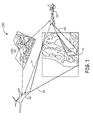
- Figure 1 illustrates an exemplary application environment for wide baseline feature matching using collaborative navigation
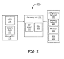
- Figure 2 is a block diagram of a platform configuration according to one embodiment
- Figure 3 is a flow diagram of a method for feature extraction and computing three-dimensional features
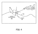
- FIG. 4 is a schematic diagram illustrating an exemplary Digital Terrain Elevation Data (DTED) constraint used in aircraft navigation;
- DTED Digital Terrain Elevation Data
- Figure 5 is a flow diagram of a method for initial feature matching
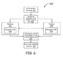
- Figure 6 is a flow diagram of a method for feature matching refinement using collaborative filters.
- a method and system are provided for wide baseline feature matching using collaborative navigation and Digital Terrain Elevation Data (DTED) constraints.
- the method can be implemented by a wide baseline feature matching algorithm using DTED and collaborative filters, which share the same observations.
- the present approach facilitates collaborative, GPS-denied navigation of multiple vehicles.
- sensor feature matching in a wide baseline environment is provided.
- An image sensor such as an electro-optical (EO) sensor is mounted on two or more different vehicles, and the field of view of each image sensor shares the same observations.
- Feature extraction is then performed in each vehicle.
- the three-dimensional (3-D) feature points are calculated using vehicle position and a camera model, and constrained by DTED.
- the resulting 3-D feature location provide a geometric constraint to the feature matching of the extracted features in the two vehicles.
- An initial feature matching step utilizes a combination of spatial neighborhood and similarity of features.
- a small subset of features from a common feature zone is input to a collaborative filter in each vehicle. By observing the consistency of the other subset features in the common feature zone from the collaborative filters, the feature matching is updated.
- the present method and system can use the DTED to resolve the vertical position of the 3-D landmark position.
- the DTED is a satellite-based survey of the Earth surface.
- One example of the vertical position can be implemented by intersecting the three dimensional DTED map with the landmark's image projection to the ellipsoid of the earth.
- the present method and system can be implemented into navigation filters.
- a navigation process is simultaneous localization and mapping (SLAM) for navigation of the vehicle and building a map of the environment simultaneously.
- Another navigation process uses an extended Kalman filter with the state vector, which includes the navigation parameters (position, velocity, and attitude), and a set of landmarks.
- the landmarks are modeled as stationary with respect to the earth. For example, in one implementation, the landmark can be tracked for a period of time to provide the navigation solution. A new landmark can then be added. The old landmark, which does not have correspondence features for a given period of time, will then be pruned from the state vector in the extended Kalman filter.
- the present method and system can be employed with any grouping of navigation vehicle platforms, including air vehicle and ground vehicles.
- One example of a group of navigation platforms can have one high flier aircraft and one low flier aircraft.
- the low flier aircraft can be an unmanned aerial vehicle (UAV).
- UAV unmanned aerial vehicle
- Another example of a group of navigation platforms can have one air vehicle and one ground vehicle.
- the ground vehicle can bean unmanned ground vehicle, a tank, or the like.
- the present method and system provide communication links between the navigation platforms.
- a communication link can be a communication radio.
- the collaborative navigation between two or more platforms is through the communication link between the two or more platforms.
- the collaborative navigation filters can improve the feature matching for the two or more platforms.
- FIG. 1 shows an exemplary application environment 100 for the present method, in which two vehicles are shown, including a high altitude aircraft 102 such as a jet and a low altitude aircraft 104 such as a UAV.
- a field of view 106 of aircraft 102 and a field of view 108 of aircraft 104 have an overlapping field of view 110.
- Radio ranging measurements are made between aircraft 102 and aircraft 104, and cameras on each of these vehicles can observe common landmarks on the terrain.
- Communication links also connect aircraft 102 and aircraft 104.
- These two vehicles can use shared information 112 to perform collaborative navigation.
- the shared information 112 can include range between the two vehicles, and the features extracted by each vehicle.
- Digital Terrain Elevation Data (DTED) 114 can be accessed by each vehicle.
- DTED Digital Terrain Elevation Data
- FIG. 2 is depicts one embodiment of a platform 200 that can implement the present approach.
- the platform 200 such as a vehicle includes at least one processing unit 201 having at least one EO sensor 202 such as a digital camera, and at least one inertial measurement unit (IMU) 203 mounted on the vehicle.
- the IMU 203 is configured to provide data regarding the motion of platform 200.
- the IMU 203 includes three mutually orthogonal linear accelerometers and three mutually orthogonal gyroscopes to provide six channels of data.
- the IMU 203 provides the inertial motion data to processing unit 201.
- the frame rate of EO sensor 202 can be different from the sample rate from IMU 203.
- Optional aiding sensors 204 can be in operative communication with processing unit 201, and can include at least one magnetic sensor 205, an altimeter 206, and a global position system (GPS) receiver 207.
- a memory unit 210 contains DTED 208 and a camera model 209, which can be accessed by processing unit 201.
- the present method and system can use the sensors in Figure 2 to form the inertial navigation system.
- the inertial navigation system employs the inertial measurement unit and aiding sensors to generate the navigation states including position, velocity, and attitude.
- the inertial navigation function uses the compensated sensor data ( ⁇ v and ⁇ ) in the body frame from the inertial sensor function to calculate the vehicle state including position, velocity, and attitude.
- the mechanism can be either a gimbaled platform or a strap-down unit.
- the strap-down unit can be used in one embodiment.
- One example of the navigation process uses a Kalman filter to perform the sensor fusion of the inertial measurement unit and the aiding sensor.
- the Kalman filter uses additional aiding sensor measurements to remove the drift error of the inertial navigation results.
- Another exemplary navigation filter can be a particle filter, which can represent the nonlinear process model and non-Gaussian error distribution. More generic filters can be used as well.
- the elevation data for the terrain can be represented by the DTED. There is a difference in elevation for different points in the ground.
- the DTED can be accessed by each platform.
- FIG. 3 is a flow diagram of a method for feature extraction and computing 3-D features according to one approach.
- an EO sensor 301 on each vehicle captures one or more images 302 to be processed.
- a two dimensional (2-D) feature extraction process 303 is then performed in each vehicle.
- SURF 2-D Speed-Up Robust Features
- Other local image feature descriptors can also be extracted, such as Scaled Invariant Features Transform (SIFT).
- SIFT Scaled Invariant Features Transform
- an 'interest point' such as corners or a T-junction is selected first.
- One approach for the interest point detection uses a Hessian-matrix approximation. After that, the neighborhood of every interest point is represented by a feature vector.
- a 4*4 sub-region can be used for the SURF feature.
- a Haar wavelet responses at 5*5 regularly spaced sample points are calculated for each sub-region.
- the wavelet responses are summed up over each sub-region and form the entries in the feature vector.
- a SURF-64 feature or a SURF-128 feature can be extracted.
- the SURF feature descriptor can be matched using a distance between two SURF feature descriptors.
- the distance can be the Mahalanobis or Euclidean distance.
- the tracked feature points can be formed by finding the matched SURF feature descriptors between the successive image frames collected by the single vehicle.
- the tracked features can be included in the state vector of the Kalman filters of the navigation solution.
- Each feature is associated with a physical 3-D point.
- the scale of a scene can be uniquely determined using a ranging measurement between the two vehicles.
- a 3-D feature location on the ellipsoid of the Earth surface computation can be processed at 304 using a calibrated camera model 305 and a navigation state of the vehicle 306.
- the camera model 305 can include the focal length, principal point, skew coefficient, radial and tangential distortion parameters, etc.
- the navigation state of the vehicle has the position, velocity, and the attitude of the vehicle in the state vector.
- the altitude of the vehicle is also available.
- a DTED 307 is used as a constraint for a 3-D feature location update at 308.
- the landmark location can then be projected onto a DTED surface to generate a 3-D point feature with the DTED surface.
- One example is to intersect the three dimensional DTED map with the landmark's image projection to provide a good estimate of elevation.
- Figure 4 illustrates an exemplary DTED constraint used in aircraft navigation.
- a landmark 401 is projected onto a DTED surface 403 by an aircraft 405 to generate an updated 3-D location 402 such as a landmark position estimate that is more accurate and robust than a monocular camera projection.
- the results of this projection may occasionally be erroneous due to the noise sensitivity of the 3-D structure computation from 2-D images.
- Each time a point is projected onto DTED surface 403, the result contains errors due to navigation uncertainties as well as uncertainties in the DTED structure - particularly when comparing visual features (e.g., tree tops, hill tops, etc.), to bare-earth DTED and sensor errors.
- Figure 4 shows the bias ( ⁇ c) 410 due to DTED map elevation uncertainty and unmodeled structure in bare-earth DTED.
- the parameter n represents the normal to the surface of the DTED.
- FIG. 5 is a flow diagram of a method 500 for initial feature matching using a combination of spatial neighborhood and similarity of feature appearance descriptors.
- a first platform 501 includes a 3-D feature location module 503 and a 2-D feature descriptor module 504.
- a second platform 502 includes a 3-D feature location module 505 and a 2-D feature descriptor module 506.
- the initial feature matching is performed at 507 with data received from platforms 501 and 502 using small window feature matching.
- the 3-D feature locations computed in platform 501, and the 3-D feature locations computed in platform 502 provide a neighborhood searching area for the feature matching.
- the 2-D feature descriptors computed in modules 504 and 506, such as SURF features are matched in the neighborhood.
- Figure 5 there is a communication link between the navigation platforms.
- a communication link can be a communication radio.
- the collaborative navigation between the two platforms is through the communication between the two platforms.
- the initial feature matching in Figure 5 is performed when the two platforms are within the communication range.
- the collaborative navigation filter is established.
- the collaborative navigation can improve the feature matching.
- the Kalman filter in one platform can use its own measurement and measurements from other platforms to enhance the navigation solution of all the platforms.
- the collaborative filters are to use the conditional update, which allows information to be exchanged directly between separate but partially correlated Kalman filters in the separate platforms.
- the states will include position, velocity, and attitude of the platform, the states required by the aiding sensor, and the landmark observed by the platform.
- the state of the collaborative filters can include the position, velocity, and attitude states of each of the two platforms involved, the landmark measurement, and the range measurement states shared between the two platforms.
- Figure 6 is a flow diagram of a method 600 for feature matching refinement using collaborative filters, in which there is collaboration between a platform 603 and a platform 605 for pruning of falsely matched features.
- An initial feature matching is performed at 601 such as described above in Figure 5 , followed by choosing a subset of features in a common feature pool or zone at 602.
- the subset of features chosen at 602 is shared between individual platform navigation filters 604 and 606 in platforms 603 and 605, respectively.
- the navigation filters 604 and 606 act in a collaborative manner between platforms 603 and 605 to perform a conditional update using the subset of the same observation data set from 602, and 3-D feature points are shared by the two platforms.
- a convergence test on the other subset in the common feature pool is performed at 607, and the 3-D position of the other subset of the same observation dataset can be calculated. After that, there is a pruning of falsely matched features at 608 by observing whether the other subset of the datasets converges. Then the feature matching task can be completed.
- a computer or processor used in the present system and method can be implemented using software, firmware, hardware, or any appropriate combination thereof, as known to one of skill in the art. These may be supplemented by, or incorporated in, specially-designed application-specific integrated circuits (ASICs) or field programmable gate arrays (FPGAs).
- ASICs application-specific integrated circuits
- FPGAs field programmable gate arrays
- the computer or processor can also include or function with software programs, firmware, or other computer readable instructions for carrying out various process tasks, calculations, and control functions used in the present method and system.
- the present methods can be implemented by computer executable instructions, such as program modules or components, which are executed by at least one processor.
- program modules include routines, programs, objects, data components, data structures, algorithms, and the like, which perform particular tasks or implement particular abstract data types.
- Instructions for carrying out the various process tasks, calculations, and generation of other data used in the operation of the methods described herein can be implemented in software, firmware, or other computer readable instructions. These instructions are typically stored on any appropriate computer program product that includes a computer readable medium used for storage of computer readable instructions or data structures. Such a computer readable medium can be any available media that can be accessed by a general purpose or special purpose computer or processor, or any programmable logic device.
- Suitable computer readable storage media may include, for example, non-volatile memory devices including semiconductor memory devices such as EPROM, EEPROM, or flash memory devices; magnetic disks such as internal hard disks or removable disks; magneto-optical disks; CDs, DVDs, Blu-ray discs, or other optical storage disks; nonvolatile ROM, RAM, and other like media; or any other media that can be used to carry or store desired program code in the form of computer executable instructions or data structures.
- non-volatile memory devices including semiconductor memory devices such as EPROM, EEPROM, or flash memory devices; magnetic disks such as internal hard disks or removable disks; magneto-optical disks; CDs, DVDs, Blu-ray discs, or other optical storage disks; nonvolatile ROM, RAM, and other like media; or any other media that can be used to carry or store desired program code in the form of computer executable instructions or data structures.
Landscapes
- Engineering & Computer Science (AREA)
- Computer Vision & Pattern Recognition (AREA)
- Physics & Mathematics (AREA)
- General Physics & Mathematics (AREA)
- Theoretical Computer Science (AREA)
- Navigation (AREA)
- Image Analysis (AREA)
Applications Claiming Priority (1)
| Application Number | Priority Date | Filing Date | Title |
|---|---|---|---|
| US13/053,777 US8660338B2 (en) | 2011-03-22 | 2011-03-22 | Wide baseline feature matching using collobrative navigation and digital terrain elevation data constraints |
Publications (2)
| Publication Number | Publication Date |
|---|---|
| EP2503510A1 true EP2503510A1 (fr) | 2012-09-26 |
| EP2503510B1 EP2503510B1 (fr) | 2013-07-24 |
Family
ID=46027565
Family Applications (1)
| Application Number | Title | Priority Date | Filing Date |
|---|---|---|---|
| EP12160019.1A Active EP2503510B1 (fr) | 2011-03-22 | 2012-03-16 | Mise en correspondance des caractéristiques sous large base stéréo utilisant une navigation collaborative et contrainte par des données numériques d'élévation de terrain |
Country Status (2)
| Country | Link |
|---|---|
| US (1) | US8660338B2 (fr) |
| EP (1) | EP2503510B1 (fr) |
Cited By (5)
| Publication number | Priority date | Publication date | Assignee | Title |
|---|---|---|---|---|
| EP2738517A1 (fr) * | 2012-12-03 | 2014-06-04 | Honeywell International Inc. | Système et procédés de sélection de caractéristiques et d'adaptation |
| WO2018200039A1 (fr) * | 2017-04-24 | 2018-11-01 | The Charles Stark Draper Laboratory, Inc. | Architecture de système de navigation distribuée à sources multiples |
| CN112945244A (zh) * | 2021-02-03 | 2021-06-11 | 西华大学 | 适用于复杂立交桥的快速导航系统及导航方法 |
| US11043132B1 (en) | 2017-02-17 | 2021-06-22 | The Charles Stark Draper Laboratory, Inc. | Systems and methods for determining quality and integrity of source information to determine navigation information of an object |
| US11774602B1 (en) | 2017-04-24 | 2023-10-03 | The Charles Stark Draper Laboratory, Inc. | Multi-source distributed navigation system architecture |
Families Citing this family (70)
| Publication number | Priority date | Publication date | Assignee | Title |
|---|---|---|---|---|
| US8868323B2 (en) | 2011-03-22 | 2014-10-21 | Honeywell International Inc. | Collaborative navigation using conditional updates |
| US9792701B2 (en) * | 2011-11-08 | 2017-10-17 | Saab Ab | Method and system for determining a relation between a first scene and a second scene |
| US8442765B1 (en) | 2012-11-08 | 2013-05-14 | Honeywell International Inc. | Shared state selection and data exchange for collaborative navigation using conditionally independent parallel filters |
| US9104752B2 (en) | 2012-11-16 | 2015-08-11 | Honeywell International Inc. | Data sharing among conditionally independent parallel filters |
| RU2535184C2 (ru) * | 2013-01-11 | 2014-12-10 | Федеральное государственное бюджетное образовательное учреждение высшего профессионального образования "Южно-Российский государственный университет экономики и сервиса" (ФГБОУ ВПО "ЮРГУЭС") | Способ и устройство детектирования локальных особенностей на изображении |
| US9761002B2 (en) * | 2013-07-30 | 2017-09-12 | The Boeing Company | Stereo-motion method of three-dimensional (3-D) structure information extraction from a video for fusion with 3-D point cloud data |
| DK3063696T3 (da) * | 2013-10-31 | 2021-09-20 | Aerovironment Inc | Interaktivt våbenmålsøgningssystem, som viser fjernregistreret billede af målområde |
| WO2015175053A2 (fr) * | 2014-02-17 | 2015-11-19 | Westerngeco Llc | Guidage de décision |
| US9235215B2 (en) | 2014-04-03 | 2016-01-12 | Honeywell International Inc. | Feature set optimization in vision-based positioning |
| WO2015200086A1 (fr) * | 2014-06-23 | 2015-12-30 | Sikorsky Aircraft Corporation | Détermination coopérative d'une zone d'atterrissage sûre |
| US9396554B2 (en) | 2014-12-05 | 2016-07-19 | Symbol Technologies, Llc | Apparatus for and method of estimating dimensions of an object associated with a code in automatic response to reading the code |
| EP3123260B1 (fr) * | 2014-12-31 | 2021-04-14 | SZ DJI Technology Co., Ltd. | Traitement sélectif de données de capteur |
| IL239148A0 (en) * | 2015-06-02 | 2015-11-30 | Elbit Systems Ltd | A method and system for calculating and presenting areas that can be reached while maintaining space-space |
| US10352689B2 (en) | 2016-01-28 | 2019-07-16 | Symbol Technologies, Llc | Methods and systems for high precision locationing with depth values |
| US10145955B2 (en) | 2016-02-04 | 2018-12-04 | Symbol Technologies, Llc | Methods and systems for processing point-cloud data with a line scanner |
| US10721451B2 (en) | 2016-03-23 | 2020-07-21 | Symbol Technologies, Llc | Arrangement for, and method of, loading freight into a shipping container |
| US9805240B1 (en) | 2016-04-18 | 2017-10-31 | Symbol Technologies, Llc | Barcode scanning and dimensioning |
| US10776661B2 (en) | 2016-08-19 | 2020-09-15 | Symbol Technologies, Llc | Methods, systems and apparatus for segmenting and dimensioning objects |
| US9866313B1 (en) * | 2016-12-14 | 2018-01-09 | T-Mobile Usa, Inc. | UAV cellular communication service delivery |
| US11042161B2 (en) | 2016-11-16 | 2021-06-22 | Symbol Technologies, Llc | Navigation control method and apparatus in a mobile automation system |
| US10451405B2 (en) | 2016-11-22 | 2019-10-22 | Symbol Technologies, Llc | Dimensioning system for, and method of, dimensioning freight in motion along an unconstrained path in a venue |
| US10354411B2 (en) | 2016-12-20 | 2019-07-16 | Symbol Technologies, Llc | Methods, systems and apparatus for segmenting objects |
| US10949798B2 (en) | 2017-05-01 | 2021-03-16 | Symbol Technologies, Llc | Multimodal localization and mapping for a mobile automation apparatus |
| US11449059B2 (en) | 2017-05-01 | 2022-09-20 | Symbol Technologies, Llc | Obstacle detection for a mobile automation apparatus |
| US11093896B2 (en) | 2017-05-01 | 2021-08-17 | Symbol Technologies, Llc | Product status detection system |
| US10663590B2 (en) | 2017-05-01 | 2020-05-26 | Symbol Technologies, Llc | Device and method for merging lidar data |
| AU2018261257B2 (en) | 2017-05-01 | 2020-10-08 | Symbol Technologies, Llc | Method and apparatus for object status detection |
| US10726273B2 (en) | 2017-05-01 | 2020-07-28 | Symbol Technologies, Llc | Method and apparatus for shelf feature and object placement detection from shelf images |
| US10591918B2 (en) | 2017-05-01 | 2020-03-17 | Symbol Technologies, Llc | Fixed segmented lattice planning for a mobile automation apparatus |
| US11367092B2 (en) | 2017-05-01 | 2022-06-21 | Symbol Technologies, Llc | Method and apparatus for extracting and processing price text from an image set |
| WO2018201423A1 (fr) | 2017-05-05 | 2018-11-08 | Symbol Technologies, Llc | Procédé et appareil pour détecter et interpréter un texte d'étiquette de prix |
| US10572763B2 (en) | 2017-09-07 | 2020-02-25 | Symbol Technologies, Llc | Method and apparatus for support surface edge detection |
| US10521914B2 (en) | 2017-09-07 | 2019-12-31 | Symbol Technologies, Llc | Multi-sensor object recognition system and method |
| US10784841B2 (en) | 2018-03-08 | 2020-09-22 | Cnh Industrial America Llc | Kalman filter for an autonomous work vehicle system |
| US11327504B2 (en) | 2018-04-05 | 2022-05-10 | Symbol Technologies, Llc | Method, system and apparatus for mobile automation apparatus localization |
| US10809078B2 (en) | 2018-04-05 | 2020-10-20 | Symbol Technologies, Llc | Method, system and apparatus for dynamic path generation |
| US10832436B2 (en) | 2018-04-05 | 2020-11-10 | Symbol Technologies, Llc | Method, system and apparatus for recovering label positions |
| US10823572B2 (en) | 2018-04-05 | 2020-11-03 | Symbol Technologies, Llc | Method, system and apparatus for generating navigational data |
| US10740911B2 (en) | 2018-04-05 | 2020-08-11 | Symbol Technologies, Llc | Method, system and apparatus for correcting translucency artifacts in data representing a support structure |
| CN109032180A (zh) * | 2018-08-14 | 2018-12-18 | 深圳市烽焌信息科技有限公司 | 一种基于无人机的修剪方法 |
| US11506483B2 (en) | 2018-10-05 | 2022-11-22 | Zebra Technologies Corporation | Method, system and apparatus for support structure depth determination |
| US11010920B2 (en) | 2018-10-05 | 2021-05-18 | Zebra Technologies Corporation | Method, system and apparatus for object detection in point clouds |
| US11055862B2 (en) * | 2018-10-26 | 2021-07-06 | Here Global B.V. | Method, apparatus, and system for generating feature correspondence between image views |
| US11003188B2 (en) | 2018-11-13 | 2021-05-11 | Zebra Technologies Corporation | Method, system and apparatus for obstacle handling in navigational path generation |
| US11090811B2 (en) | 2018-11-13 | 2021-08-17 | Zebra Technologies Corporation | Method and apparatus for labeling of support structures |
| US11079240B2 (en) | 2018-12-07 | 2021-08-03 | Zebra Technologies Corporation | Method, system and apparatus for adaptive particle filter localization |
| US11416000B2 (en) | 2018-12-07 | 2022-08-16 | Zebra Technologies Corporation | Method and apparatus for navigational ray tracing |
| US11100303B2 (en) | 2018-12-10 | 2021-08-24 | Zebra Technologies Corporation | Method, system and apparatus for auxiliary label detection and association |
| US11015938B2 (en) | 2018-12-12 | 2021-05-25 | Zebra Technologies Corporation | Method, system and apparatus for navigational assistance |
| US10970878B2 (en) * | 2018-12-13 | 2021-04-06 | Lyft, Inc. | Camera calibration using reference map |
| US10731970B2 (en) | 2018-12-13 | 2020-08-04 | Zebra Technologies Corporation | Method, system and apparatus for support structure detection |
| CA3028708C (fr) | 2018-12-28 | 2025-12-09 | Zebra Technologies Corporation | Procede, systeme et appareil de fermeture dynamique des boucles dans des trajectoires de cartographie |
| CN110109163B (zh) * | 2019-04-09 | 2022-01-07 | 天津大学 | 一种附有高程约束的精密单点定位方法 |
| CN110109167B (zh) * | 2019-04-18 | 2021-12-07 | 天津大学 | 一种基于高程约束的海上精密定位方法 |
| CN110162072A (zh) * | 2019-05-28 | 2019-08-23 | 哈尔滨工业大学 | 四旋翼飞行器三自由度姿态控制实验装置 |
| US11402846B2 (en) | 2019-06-03 | 2022-08-02 | Zebra Technologies Corporation | Method, system and apparatus for mitigating data capture light leakage |
| US11341663B2 (en) | 2019-06-03 | 2022-05-24 | Zebra Technologies Corporation | Method, system and apparatus for detecting support structure obstructions |
| US11960286B2 (en) | 2019-06-03 | 2024-04-16 | Zebra Technologies Corporation | Method, system and apparatus for dynamic task sequencing |
| US11662739B2 (en) | 2019-06-03 | 2023-05-30 | Zebra Technologies Corporation | Method, system and apparatus for adaptive ceiling-based localization |
| US11200677B2 (en) | 2019-06-03 | 2021-12-14 | Zebra Technologies Corporation | Method, system and apparatus for shelf edge detection |
| US11080566B2 (en) | 2019-06-03 | 2021-08-03 | Zebra Technologies Corporation | Method, system and apparatus for gap detection in support structures with peg regions |
| US11507103B2 (en) | 2019-12-04 | 2022-11-22 | Zebra Technologies Corporation | Method, system and apparatus for localization-based historical obstacle handling |
| US11107238B2 (en) | 2019-12-13 | 2021-08-31 | Zebra Technologies Corporation | Method, system and apparatus for detecting item facings |
| US11822333B2 (en) | 2020-03-30 | 2023-11-21 | Zebra Technologies Corporation | Method, system and apparatus for data capture illumination control |
| US11450024B2 (en) | 2020-07-17 | 2022-09-20 | Zebra Technologies Corporation | Mixed depth object detection |
| US11593915B2 (en) | 2020-10-21 | 2023-02-28 | Zebra Technologies Corporation | Parallax-tolerant panoramic image generation |
| US11392891B2 (en) | 2020-11-03 | 2022-07-19 | Zebra Technologies Corporation | Item placement detection and optimization in material handling systems |
| US11847832B2 (en) | 2020-11-11 | 2023-12-19 | Zebra Technologies Corporation | Object classification for autonomous navigation systems |
| US11954882B2 (en) | 2021-06-17 | 2024-04-09 | Zebra Technologies Corporation | Feature-based georegistration for mobile computing devices |
| CN117556180B (zh) * | 2023-11-14 | 2024-06-25 | 中国科学院地质与地球物理研究所 | 一种半航空电磁法探测高程估计方法 |
Family Cites Families (25)
| Publication number | Priority date | Publication date | Assignee | Title |
|---|---|---|---|---|
| WO1991019265A1 (fr) | 1990-05-29 | 1991-12-12 | Axiom Innovation Limited | Mise en correspondance en stereo vision machine |
| US5179441A (en) | 1991-12-18 | 1993-01-12 | The United States Of America As Represented By The Administrator Of The National Aeronautics And Space Administration | Near real-time stereo vision system |
| GB0117541D0 (en) | 2001-07-19 | 2003-08-06 | Bae Systems Plc | Automatic registration of images in digital terrain elevation data |
| US6803878B2 (en) * | 2002-05-13 | 2004-10-12 | Honeywell International Inc. | Methods and apparatus for terrain correlation |
| US6922632B2 (en) | 2002-08-09 | 2005-07-26 | Intersense, Inc. | Tracking, auto-calibration, and map-building system |
| US20050216182A1 (en) | 2004-03-24 | 2005-09-29 | Hussain Talib S | Vehicle routing and path planning |
| US6885334B1 (en) | 2004-04-06 | 2005-04-26 | Honeywell International Inc. | Methods and systems for detecting forward obstacles |
| US7831094B2 (en) | 2004-04-27 | 2010-11-09 | Honda Motor Co., Ltd. | Simultaneous localization and mapping using multiple view feature descriptors |
| US7409293B2 (en) | 2004-06-03 | 2008-08-05 | Honeywell International Inc. | Methods and systems for enhancing accuracy of terrain aided navigation systems |
| US8666661B2 (en) | 2006-03-31 | 2014-03-04 | The Boeing Company | Video navigation |
| US8139109B2 (en) | 2006-06-19 | 2012-03-20 | Oshkosh Corporation | Vision system for an autonomous vehicle |
| US7698108B2 (en) | 2006-10-10 | 2010-04-13 | Haney Philip J | Parameterization of non-linear/non-Gaussian data distributions for efficient information sharing in distributed sensor networks |
| US7489268B2 (en) * | 2007-01-08 | 2009-02-10 | Honeywell International Inc. | Methods and systems for producing an interpretive airborne radar map |
| US8126273B2 (en) | 2007-04-05 | 2012-02-28 | Siemens Corporation | Method for reconstructing three-dimensional images from two-dimensional image data |
| US7831391B2 (en) | 2007-06-12 | 2010-11-09 | Palo Alto Research Center Incorporated | Using segmented cones for fast, conservative assessment of collision risk |
| IL191615A (en) | 2007-10-23 | 2015-05-31 | Israel Aerospace Ind Ltd | A method and system for producing tie points for use in stereo adjustment of stereoscopic images and a method for identifying differences in the landscape taken between two time points |
| US7821453B2 (en) | 2007-12-20 | 2010-10-26 | Sarnoff Corporation | Distributed iterative multimodal sensor fusion method for improved collaborative localization and navigation |
| GB2458278A (en) | 2008-03-11 | 2009-09-16 | Geoffrey Cross | A method of recognising signs in images taken from video data |
| US8244469B2 (en) | 2008-03-16 | 2012-08-14 | Irobot Corporation | Collaborative engagement for target identification and tracking |
| US8363973B2 (en) | 2008-10-01 | 2013-01-29 | Fuji Xerox Co., Ltd. | Descriptor for image corresponding point matching |
| US8254697B2 (en) | 2009-02-02 | 2012-08-28 | Microsoft Corporation | Scalable near duplicate image search with geometric constraints |
| US8296056B2 (en) * | 2009-04-20 | 2012-10-23 | Honeywell International Inc. | Enhanced vision system for precision navigation in low visibility or global positioning system (GPS) denied conditions |
| US9068847B2 (en) * | 2009-04-22 | 2015-06-30 | Honeywell International Inc. | System and method for collaborative navigation |
| FR2954494B1 (fr) * | 2009-12-18 | 2012-07-27 | Thales Sa | Procede de calibrage d'un instrument de mesure d'un systeme optronique |
| US8868323B2 (en) | 2011-03-22 | 2014-10-21 | Honeywell International Inc. | Collaborative navigation using conditional updates |
-
2011
- 2011-03-22 US US13/053,777 patent/US8660338B2/en active Active
-
2012
- 2012-03-16 EP EP12160019.1A patent/EP2503510B1/fr active Active
Non-Patent Citations (3)
| Title |
|---|
| AVEEK DAS ET AL: "Robust visual path following for heterogeneous mobile platforms", 2010 IEEE INTERNATIONAL CONFERENCE ON ROBOTICS AND AUTOMATION : ICRA 2010 ; ANCHORAGE, ALASKA, USA, 3 - 8 MAY 2010, IEEE, PISCATAWAY, NJ, USA, 3 May 2010 (2010-05-03), pages 2431 - 2437, XP031743634, ISBN: 978-1-4244-5038-1 * |
| MAURICE F FALLON ET AL: "A measurement distribution framework for cooperative navigation using multiple AUVs", 2010 IEEE INTERNATIONAL CONFERENCE ON ROBOTICS AND AUTOMATION : ICRA 2010 ; ANCHORAGE, ALASKA, USA, 3 - 8 MAY 2010, IEEE, PISCATAWAY, NJ, USA, 3 May 2010 (2010-05-03), pages 4256 - 4263, XP031743804, ISBN: 978-1-4244-5038-1 * |
| SPENNEBERG D ET AL: "Exploration of underwater structures with cooperative heterogeneous robots", OCEANS 2005 - EUROPE BREST, FRANCE 20-23 JUNE 2005, PISCATAWAY, NJ, USA,IEEE, US, vol. 2, 20 June 2005 (2005-06-20), pages 782 - 786Vol.2, XP010838250, ISBN: 978-0-7803-9103-1 * |
Cited By (8)
| Publication number | Priority date | Publication date | Assignee | Title |
|---|---|---|---|---|
| EP2738517A1 (fr) * | 2012-12-03 | 2014-06-04 | Honeywell International Inc. | Système et procédés de sélection de caractéristiques et d'adaptation |
| US9082008B2 (en) | 2012-12-03 | 2015-07-14 | Honeywell International Inc. | System and methods for feature selection and matching |
| US11043132B1 (en) | 2017-02-17 | 2021-06-22 | The Charles Stark Draper Laboratory, Inc. | Systems and methods for determining quality and integrity of source information to determine navigation information of an object |
| WO2018200039A1 (fr) * | 2017-04-24 | 2018-11-01 | The Charles Stark Draper Laboratory, Inc. | Architecture de système de navigation distribuée à sources multiples |
| US11150357B2 (en) | 2017-04-24 | 2021-10-19 | The Charles Stark Draper Laboratory, Inc. | Multi-source distributed navigation system architecture |
| US11774602B1 (en) | 2017-04-24 | 2023-10-03 | The Charles Stark Draper Laboratory, Inc. | Multi-source distributed navigation system architecture |
| US12235368B2 (en) | 2017-04-24 | 2025-02-25 | The Charles Stark Draper Laboratory, Inc. | Multi-source distributed navigation system architecture |
| CN112945244A (zh) * | 2021-02-03 | 2021-06-11 | 西华大学 | 适用于复杂立交桥的快速导航系统及导航方法 |
Also Published As
| Publication number | Publication date |
|---|---|
| EP2503510B1 (fr) | 2013-07-24 |
| US8660338B2 (en) | 2014-02-25 |
| US20120243775A1 (en) | 2012-09-27 |
Similar Documents
| Publication | Publication Date | Title |
|---|---|---|
| US8660338B2 (en) | Wide baseline feature matching using collobrative navigation and digital terrain elevation data constraints | |
| JP6410530B2 (ja) | Vslam最適化のための方法 | |
| US8213706B2 (en) | Method and system for real-time visual odometry | |
| US10182212B2 (en) | Wide area intermittent video using non-orthorectified feature matching in long period aerial image capture with pixel-based georeferencing | |
| US9959625B2 (en) | Method for fast camera pose refinement for wide area motion imagery | |
| Kinnari et al. | GNSS-denied geolocalization of UAVs by visual matching of onboard camera images with orthophotos | |
| US10740608B2 (en) | Wide area intermittent video using non-orthorectified feature matching in long period aerial image capture with pixel-based georeferencing | |
| US20190385361A1 (en) | Reconstruction of a scene from a moving camera | |
| Samadzadegan et al. | Autonomous navigation of Unmanned Aerial Vehicles based on multi-sensor data fusion | |
| Dumble et al. | Airborne vision-aided navigation using road intersection features | |
| CN115127554B (zh) | 一种基于多源视觉辅助的无人机自主导航方法与系统 | |
| CN117330052A (zh) | 基于红外视觉、毫米波雷达和imu融合的定位与建图方法及系统 | |
| Javed et al. | PanoVILD: A challenging panoramic vision, inertial and LiDAR dataset for simultaneous localization and mapping | |
| Andolfo et al. | Precise pose estimation of the NASA Mars 2020 Perseverance rover through a stereo‐vision‐based approach | |
| Zhu et al. | Architecture for asymmetric collaborative navigation | |
| Li et al. | Aerial-triangulation aided boresight calibration for a low-cost UAV-LiDAR system | |
| KR20210098534A (ko) | 포지셔닝을 위한 환경 모델을 생성하기 위한 방법 및 시스템 | |
| Dill | GPS/Optical/Inertial Integration for 3D Navigation and Mapping Using Multi-copter Platforms | |
| Mahon | Vision-based navigation for autonomous underwater vehicles | |
| Di Corato et al. | Robust vision-aided inertial navigation algorithm via entropy-like relative pose estimation | |
| Chiodini et al. | Rover relative localization testing in martian relevant environment | |
| Andert et al. | A flight state estimator that combines stereo-vision, INS, and satellite pseudo-ranges | |
| Sanfourche et al. | 3DSCAN: Online ego-localization and environment mapping for micro aerial vehicles | |
| Hurwitz et al. | Relative Constraints and Their Contribution to Image Configurations | |
| Zhou | Integration of Camera and LiDAR Units onboard Mobile Mapping Systems for Deriving Accurate, Comprehensive Products |
Legal Events
| Date | Code | Title | Description |
|---|---|---|---|
| PUAI | Public reference made under article 153(3) epc to a published international application that has entered the european phase |
Free format text: ORIGINAL CODE: 0009012 |
|
| 17P | Request for examination filed |
Effective date: 20120316 |
|
| AK | Designated contracting states |
Kind code of ref document: A1 Designated state(s): AL AT BE BG CH CY CZ DE DK EE ES FI FR GB GR HR HU IE IS IT LI LT LU LV MC MK MT NL NO PL PT RO RS SE SI SK SM TR |
|
| AX | Request for extension of the european patent |
Extension state: BA ME |
|
| GRAP | Despatch of communication of intention to grant a patent |
Free format text: ORIGINAL CODE: EPIDOSNIGR1 |
|
| GRAS | Grant fee paid |
Free format text: ORIGINAL CODE: EPIDOSNIGR3 |
|
| GRAA | (expected) grant |
Free format text: ORIGINAL CODE: 0009210 |
|
| AK | Designated contracting states |
Kind code of ref document: B1 Designated state(s): AL AT BE BG CH CY CZ DE DK EE ES FI FR GB GR HR HU IE IS IT LI LT LU LV MC MK MT NL NO PL PT RO RS SE SI SK SM TR |
|
| REG | Reference to a national code |
Ref country code: GB Ref legal event code: FG4D |
|
| REG | Reference to a national code |
Ref country code: CH Ref legal event code: EP |
|
| REG | Reference to a national code |
Ref country code: AT Ref legal event code: REF Ref document number: 623808 Country of ref document: AT Kind code of ref document: T Effective date: 20130815 |
|
| REG | Reference to a national code |
Ref country code: IE Ref legal event code: FG4D |
|
| REG | Reference to a national code |
Ref country code: DE Ref legal event code: R096 Ref document number: 602012000148 Country of ref document: DE Effective date: 20130912 |
|
| REG | Reference to a national code |
Ref country code: AT Ref legal event code: MK05 Ref document number: 623808 Country of ref document: AT Kind code of ref document: T Effective date: 20130724 |
|
| REG | Reference to a national code |
Ref country code: NL Ref legal event code: VDEP Effective date: 20130724 |
|
| REG | Reference to a national code |
Ref country code: LT Ref legal event code: MG4D |
|
| PG25 | Lapsed in a contracting state [announced via postgrant information from national office to epo] |
Ref country code: SE Free format text: LAPSE BECAUSE OF FAILURE TO SUBMIT A TRANSLATION OF THE DESCRIPTION OR TO PAY THE FEE WITHIN THE PRESCRIBED TIME-LIMIT Effective date: 20130724 Ref country code: HR Free format text: LAPSE BECAUSE OF FAILURE TO SUBMIT A TRANSLATION OF THE DESCRIPTION OR TO PAY THE FEE WITHIN THE PRESCRIBED TIME-LIMIT Effective date: 20130724 Ref country code: IS Free format text: LAPSE BECAUSE OF FAILURE TO SUBMIT A TRANSLATION OF THE DESCRIPTION OR TO PAY THE FEE WITHIN THE PRESCRIBED TIME-LIMIT Effective date: 20131124 Ref country code: LT Free format text: LAPSE BECAUSE OF FAILURE TO SUBMIT A TRANSLATION OF THE DESCRIPTION OR TO PAY THE FEE WITHIN THE PRESCRIBED TIME-LIMIT Effective date: 20130724 Ref country code: PT Free format text: LAPSE BECAUSE OF FAILURE TO SUBMIT A TRANSLATION OF THE DESCRIPTION OR TO PAY THE FEE WITHIN THE PRESCRIBED TIME-LIMIT Effective date: 20131125 Ref country code: NO Free format text: LAPSE BECAUSE OF FAILURE TO SUBMIT A TRANSLATION OF THE DESCRIPTION OR TO PAY THE FEE WITHIN THE PRESCRIBED TIME-LIMIT Effective date: 20131024 Ref country code: CY Free format text: LAPSE BECAUSE OF FAILURE TO SUBMIT A TRANSLATION OF THE DESCRIPTION OR TO PAY THE FEE WITHIN THE PRESCRIBED TIME-LIMIT Effective date: 20130911 Ref country code: AT Free format text: LAPSE BECAUSE OF FAILURE TO SUBMIT A TRANSLATION OF THE DESCRIPTION OR TO PAY THE FEE WITHIN THE PRESCRIBED TIME-LIMIT Effective date: 20130724 Ref country code: BE Free format text: LAPSE BECAUSE OF FAILURE TO SUBMIT A TRANSLATION OF THE DESCRIPTION OR TO PAY THE FEE WITHIN THE PRESCRIBED TIME-LIMIT Effective date: 20130724 |
|
| PG25 | Lapsed in a contracting state [announced via postgrant information from national office to epo] |
Ref country code: SI Free format text: LAPSE BECAUSE OF FAILURE TO SUBMIT A TRANSLATION OF THE DESCRIPTION OR TO PAY THE FEE WITHIN THE PRESCRIBED TIME-LIMIT Effective date: 20130724 Ref country code: FI Free format text: LAPSE BECAUSE OF FAILURE TO SUBMIT A TRANSLATION OF THE DESCRIPTION OR TO PAY THE FEE WITHIN THE PRESCRIBED TIME-LIMIT Effective date: 20130724 Ref country code: LV Free format text: LAPSE BECAUSE OF FAILURE TO SUBMIT A TRANSLATION OF THE DESCRIPTION OR TO PAY THE FEE WITHIN THE PRESCRIBED TIME-LIMIT Effective date: 20130724 Ref country code: GR Free format text: LAPSE BECAUSE OF FAILURE TO SUBMIT A TRANSLATION OF THE DESCRIPTION OR TO PAY THE FEE WITHIN THE PRESCRIBED TIME-LIMIT Effective date: 20131025 Ref country code: PL Free format text: LAPSE BECAUSE OF FAILURE TO SUBMIT A TRANSLATION OF THE DESCRIPTION OR TO PAY THE FEE WITHIN THE PRESCRIBED TIME-LIMIT Effective date: 20130724 Ref country code: NL Free format text: LAPSE BECAUSE OF FAILURE TO SUBMIT A TRANSLATION OF THE DESCRIPTION OR TO PAY THE FEE WITHIN THE PRESCRIBED TIME-LIMIT Effective date: 20130724 |
|
| PG25 | Lapsed in a contracting state [announced via postgrant information from national office to epo] |
Ref country code: CY Free format text: LAPSE BECAUSE OF FAILURE TO SUBMIT A TRANSLATION OF THE DESCRIPTION OR TO PAY THE FEE WITHIN THE PRESCRIBED TIME-LIMIT Effective date: 20130724 |
|
| PG25 | Lapsed in a contracting state [announced via postgrant information from national office to epo] |
Ref country code: SK Free format text: LAPSE BECAUSE OF FAILURE TO SUBMIT A TRANSLATION OF THE DESCRIPTION OR TO PAY THE FEE WITHIN THE PRESCRIBED TIME-LIMIT Effective date: 20130724 Ref country code: RO Free format text: LAPSE BECAUSE OF FAILURE TO SUBMIT A TRANSLATION OF THE DESCRIPTION OR TO PAY THE FEE WITHIN THE PRESCRIBED TIME-LIMIT Effective date: 20130724 Ref country code: DK Free format text: LAPSE BECAUSE OF FAILURE TO SUBMIT A TRANSLATION OF THE DESCRIPTION OR TO PAY THE FEE WITHIN THE PRESCRIBED TIME-LIMIT Effective date: 20130724 Ref country code: EE Free format text: LAPSE BECAUSE OF FAILURE TO SUBMIT A TRANSLATION OF THE DESCRIPTION OR TO PAY THE FEE WITHIN THE PRESCRIBED TIME-LIMIT Effective date: 20130724 Ref country code: CZ Free format text: LAPSE BECAUSE OF FAILURE TO SUBMIT A TRANSLATION OF THE DESCRIPTION OR TO PAY THE FEE WITHIN THE PRESCRIBED TIME-LIMIT Effective date: 20130724 |
|
| PG25 | Lapsed in a contracting state [announced via postgrant information from national office to epo] |
Ref country code: ES Free format text: LAPSE BECAUSE OF FAILURE TO SUBMIT A TRANSLATION OF THE DESCRIPTION OR TO PAY THE FEE WITHIN THE PRESCRIBED TIME-LIMIT Effective date: 20130724 Ref country code: IT Free format text: LAPSE BECAUSE OF FAILURE TO SUBMIT A TRANSLATION OF THE DESCRIPTION OR TO PAY THE FEE WITHIN THE PRESCRIBED TIME-LIMIT Effective date: 20130724 |
|
| PLBE | No opposition filed within time limit |
Free format text: ORIGINAL CODE: 0009261 |
|
| STAA | Information on the status of an ep patent application or granted ep patent |
Free format text: STATUS: NO OPPOSITION FILED WITHIN TIME LIMIT |
|
| 26N | No opposition filed |
Effective date: 20140425 |
|
| REG | Reference to a national code |
Ref country code: DE Ref legal event code: R097 Ref document number: 602012000148 Country of ref document: DE Effective date: 20140425 |
|
| PG25 | Lapsed in a contracting state [announced via postgrant information from national office to epo] |
Ref country code: LU Free format text: LAPSE BECAUSE OF FAILURE TO SUBMIT A TRANSLATION OF THE DESCRIPTION OR TO PAY THE FEE WITHIN THE PRESCRIBED TIME-LIMIT Effective date: 20140316 |
|
| REG | Reference to a national code |
Ref country code: IE Ref legal event code: MM4A |
|
| PG25 | Lapsed in a contracting state [announced via postgrant information from national office to epo] |
Ref country code: IE Free format text: LAPSE BECAUSE OF NON-PAYMENT OF DUE FEES Effective date: 20140316 |
|
| REG | Reference to a national code |
Ref country code: CH Ref legal event code: PL |
|
| PG25 | Lapsed in a contracting state [announced via postgrant information from national office to epo] |
Ref country code: CH Free format text: LAPSE BECAUSE OF NON-PAYMENT OF DUE FEES Effective date: 20150331 Ref country code: LI Free format text: LAPSE BECAUSE OF NON-PAYMENT OF DUE FEES Effective date: 20150331 |
|
| REG | Reference to a national code |
Ref country code: FR Ref legal event code: PLFP Year of fee payment: 5 |
|
| PG25 | Lapsed in a contracting state [announced via postgrant information from national office to epo] |
Ref country code: MT Free format text: LAPSE BECAUSE OF FAILURE TO SUBMIT A TRANSLATION OF THE DESCRIPTION OR TO PAY THE FEE WITHIN THE PRESCRIBED TIME-LIMIT Effective date: 20130724 |
|
| PG25 | Lapsed in a contracting state [announced via postgrant information from national office to epo] |
Ref country code: SM Free format text: LAPSE BECAUSE OF FAILURE TO SUBMIT A TRANSLATION OF THE DESCRIPTION OR TO PAY THE FEE WITHIN THE PRESCRIBED TIME-LIMIT Effective date: 20130724 |
|
| PG25 | Lapsed in a contracting state [announced via postgrant information from national office to epo] |
Ref country code: MC Free format text: LAPSE BECAUSE OF FAILURE TO SUBMIT A TRANSLATION OF THE DESCRIPTION OR TO PAY THE FEE WITHIN THE PRESCRIBED TIME-LIMIT Effective date: 20130724 |
|
| PG25 | Lapsed in a contracting state [announced via postgrant information from national office to epo] |
Ref country code: RS Free format text: LAPSE BECAUSE OF FAILURE TO SUBMIT A TRANSLATION OF THE DESCRIPTION OR TO PAY THE FEE WITHIN THE PRESCRIBED TIME-LIMIT Effective date: 20130724 Ref country code: BG Free format text: LAPSE BECAUSE OF FAILURE TO SUBMIT A TRANSLATION OF THE DESCRIPTION OR TO PAY THE FEE WITHIN THE PRESCRIBED TIME-LIMIT Effective date: 20130724 |
|
| PG25 | Lapsed in a contracting state [announced via postgrant information from national office to epo] |
Ref country code: HU Free format text: LAPSE BECAUSE OF FAILURE TO SUBMIT A TRANSLATION OF THE DESCRIPTION OR TO PAY THE FEE WITHIN THE PRESCRIBED TIME-LIMIT; INVALID AB INITIO Effective date: 20120316 Ref country code: TR Free format text: LAPSE BECAUSE OF FAILURE TO SUBMIT A TRANSLATION OF THE DESCRIPTION OR TO PAY THE FEE WITHIN THE PRESCRIBED TIME-LIMIT Effective date: 20130724 |
|
| REG | Reference to a national code |
Ref country code: FR Ref legal event code: PLFP Year of fee payment: 6 |
|
| REG | Reference to a national code |
Ref country code: FR Ref legal event code: PLFP Year of fee payment: 7 |
|
| PG25 | Lapsed in a contracting state [announced via postgrant information from national office to epo] |
Ref country code: MK Free format text: LAPSE BECAUSE OF FAILURE TO SUBMIT A TRANSLATION OF THE DESCRIPTION OR TO PAY THE FEE WITHIN THE PRESCRIBED TIME-LIMIT Effective date: 20130724 |
|
| PG25 | Lapsed in a contracting state [announced via postgrant information from national office to epo] |
Ref country code: AL Free format text: LAPSE BECAUSE OF FAILURE TO SUBMIT A TRANSLATION OF THE DESCRIPTION OR TO PAY THE FEE WITHIN THE PRESCRIBED TIME-LIMIT Effective date: 20130724 |
|
| P01 | Opt-out of the competence of the unified patent court (upc) registered |
Effective date: 20230525 |
|
| PGFP | Annual fee paid to national office [announced via postgrant information from national office to epo] |
Ref country code: GB Payment date: 20260319 Year of fee payment: 15 |
|
| PGFP | Annual fee paid to national office [announced via postgrant information from national office to epo] |
Ref country code: DE Payment date: 20260320 Year of fee payment: 15 |
|
| PGFP | Annual fee paid to national office [announced via postgrant information from national office to epo] |
Ref country code: FR Payment date: 20260323 Year of fee payment: 15 |