EP2458329A2 - Système de construction de modèles d'estimation de distance pour navigation personnelle - Google Patents
Système de construction de modèles d'estimation de distance pour navigation personnelle Download PDFInfo
- Publication number
- EP2458329A2 EP2458329A2 EP11190423A EP11190423A EP2458329A2 EP 2458329 A2 EP2458329 A2 EP 2458329A2 EP 11190423 A EP11190423 A EP 11190423A EP 11190423 A EP11190423 A EP 11190423A EP 2458329 A2 EP2458329 A2 EP 2458329A2
- Authority
- EP
- European Patent Office
- Prior art keywords
- gait
- distance
- user
- information
- frequency
- Prior art date
- Legal status (The legal status is an assumption and is not a legal conclusion. Google has not performed a legal analysis and makes no representation as to the accuracy of the status listed.)
- Withdrawn
Links
Images


Classifications
-
- G—PHYSICS
- G01—MEASURING; TESTING
- G01C—MEASURING DISTANCES, LEVELS OR BEARINGS; SURVEYING; NAVIGATION; GYROSCOPIC INSTRUMENTS; PHOTOGRAMMETRY OR VIDEOGRAMMETRY
- G01C21/00—Navigation; Navigational instruments not provided for in groups G01C1/00 - G01C19/00
- G01C21/20—Instruments for performing navigational calculations
-
- G—PHYSICS
- G01—MEASURING; TESTING
- G01C—MEASURING DISTANCES, LEVELS OR BEARINGS; SURVEYING; NAVIGATION; GYROSCOPIC INSTRUMENTS; PHOTOGRAMMETRY OR VIDEOGRAMMETRY
- G01C21/00—Navigation; Navigational instruments not provided for in groups G01C1/00 - G01C19/00
- G01C21/005—Navigation; Navigational instruments not provided for in groups G01C1/00 - G01C19/00 with correlation of navigation data from several sources, e.g. map or contour matching
-
- G—PHYSICS
- G01—MEASURING; TESTING
- G01C—MEASURING DISTANCES, LEVELS OR BEARINGS; SURVEYING; NAVIGATION; GYROSCOPIC INSTRUMENTS; PHOTOGRAMMETRY OR VIDEOGRAMMETRY
- G01C21/00—Navigation; Navigational instruments not provided for in groups G01C1/00 - G01C19/00
- G01C21/10—Navigation; Navigational instruments not provided for in groups G01C1/00 - G01C19/00 by using measurements of speed or acceleration
- G01C21/12—Navigation; Navigational instruments not provided for in groups G01C1/00 - G01C19/00 by using measurements of speed or acceleration executed aboard the object being navigated; Dead reckoning
- G01C21/16—Navigation; Navigational instruments not provided for in groups G01C1/00 - G01C19/00 by using measurements of speed or acceleration executed aboard the object being navigated; Dead reckoning by integrating acceleration or speed, i.e. inertial navigation
- G01C21/165—Navigation; Navigational instruments not provided for in groups G01C1/00 - G01C19/00 by using measurements of speed or acceleration executed aboard the object being navigated; Dead reckoning by integrating acceleration or speed, i.e. inertial navigation combined with non-inertial navigation instruments
- G01C21/1654—Navigation; Navigational instruments not provided for in groups G01C1/00 - G01C19/00 by using measurements of speed or acceleration executed aboard the object being navigated; Dead reckoning by integrating acceleration or speed, i.e. inertial navigation combined with non-inertial navigation instruments with electromagnetic compass
-
- G—PHYSICS
- G01—MEASURING; TESTING
- G01C—MEASURING DISTANCES, LEVELS OR BEARINGS; SURVEYING; NAVIGATION; GYROSCOPIC INSTRUMENTS; PHOTOGRAMMETRY OR VIDEOGRAMMETRY
- G01C22/00—Measuring distance traversed on the ground by vehicles, persons, animals or other moving solid bodies, e.g. using odometers, using pedometers
- G01C22/006—Pedometers
Definitions
- SA situational awareness
- GPS Global Positioning System
- IMU inertial measurement unit
- IMU-based personal navigation solutions quickly accumulate errors due to the integration of both sensor noise and bias.
- One method for aiding an IMU-based personal navigation solution is to incorporate other sensors (for example, a compass) into the personal navigation system.
- other sensors for example, a compass
- the incorporation of other sensors increases the size, weight, power requirements, and complexity of the navigation platform.
- Embodiments of the present invention provide methods and systems for constructing Distance Estimate Models for personal navigation and will be understood by reading and studying the following specification.
- a distance estimation system comprises: a gait information memory configured to store gait information about a gait mode; a biometric data memory configured to store a biometric profile for a user; a frequency module configured to identify a gait frequency; and a distance calculation module configured to calculate the distance traveled by the user by creating a distance estimate model based on the gait mode, the biometric profile, and the gait frequency, wherein the distance calculation module creates the distance estimate model by performing a regression analysis on movement information from at least one user.
- IMU based personal navigation systems typically accumulate errors during operation due to integration of both noise and sensor bias.
- Embodiments of the present disclosure provide a distance estimation system derived from human gait models, which can reduce personal-navigation-system pose errors by constraining the estimated motion of a person.
- a human gait model defines the body motion as a function of parameters, such as gait mode, frequency, and biometric information. These models are employed to supply distance measurements to an estimator (for example, an extended Kalman filter) to reduce the errors that arise in an IMU-based personal navigation system.
- an estimator for example, an extended Kalman filter
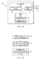
- FIG. 1A is a block diagram of a distance estimation system 100 for estimating the distance traveled by a user.
- Distance estimation system 100 includes a memory 102 configured to store information used by distance estimation system 100.
- Memory 102 includes a biometric data 105 which includes biometric information about one or more individual persons who will use a device in which distance estimation system 100 is utilized.
- biometric information includes information that describes an individual's physical characteristics. For example, biometric information includes height, leg length, thigh length, arm length, weight, gender, and the like. As people exhibit different gait patterns, biometric data 105 can parameterize the gait variations among individuals.
- Memory 102 also includes gait information 107.
- Gait information 107 includes details about a person's gait while the person is moving.
- the terms "gait” and "gait mode,” as used herein, generally refer to the pattern of movement of a user's limbs while moving from one location to another.
- gait information 107 stores data indicating a pattern of repetitive limb movements.
- Exemplary gaits represented in gait information 107 include, but are not limited to, level walking, stair ascending/descending, side-shuffle walking, duck (firefighter) walking, hand-and-knee crawling, military (elbow) crawling, jogging, running, and sprinting.
- a user enters a gait mode directly into gait information 107.
- a gait classifier system uses an algorithm to determine the gait of a user.
- a system and method for wavelet-based gait classification can be found in U.S. Patent application number 12/900315, filed October 7, 2010 , which is herein incorporated by reference.
- Distance estimation system 100 also includes a processing unit 104.
- Processing unit 104 employs the information contained in memory 102 to calculate the distance traveled by a person using distance estimation system 100.
- Processing unit 104 includes a frequency module 110 configured to determine a gait frequency from observations of an individual's motion.
- the term "frequency,” as used herein, generally refers to the number of repetitive gait motions per unit of time.
- the frequency of level walking refers to how many steps or are repeated per second, or equivalently, the inverse of the time duration of each step. For instance, an individual who takes two steps every second, has an associated frequency of 2 Hz.
- frequency module 110 applies a Fourier analysis (such as, but not limited to a Fast-Fourier Transform (FFT)) to motion information received from an IMU 112 that is coupled to processing unit 104.
- FFT Fast-Fourier Transform
- frequency module 110 identifies a dominant frequency, a group of frequencies, or an identifying frequency pattern, from the motion information. Based on this initial estimate of the gait frequency, individual step times are computed accurately using the time-difference between detected critical points in the raw IMU 112 data signals.
- the critical points are peaks, valleys, or zero-crossings (for example, time instants of highest, lowest, or zero acceleration during the gait cycle).
- frequency module 110 directly monitors the frequency of the corresponding gait.
- frequency module 110 receives the frequency estimate for the current gait from external instrumentation such as described in greater detail in Figure 3 below.
- a navigation processor provides information that indicates the frequency of a gait mode.
- other dedicated instrumentation like a gait classification module provides information about the frequency.
- a user can directly instruct frequency module 110 about the frequency of a gait.
- distance estimation system 100 includes distance calculation module 106.
- Distance calculation module 106 uses the data contained in memory 102, which contains gait information 107 and biometric data 105, along with data received from frequency module 110 to calculate the distance traveled by a user. To calculate the distance traveled by a user of distance estimation system 100, distance calculation module 106 creates a distance estimate model. Distance calculation module 106 develops the distance estimate model by performing a regression analysis on acquired training data.
- phase 150 comprises acquiring training data to populate gait information 107.
- the second phase illustrated at 160 comprises creating a distance estimation model from the gait information using model regression analysis.
- the third phase, illustrated at 170 is the operating phase comprising performing distance estimations in real time from motion information received in real time.
- FIG. 2 is a flowchart of an exemplary method 200 for the first phase 150.
- This phase involves acquiring training data that will be used in the next phase to perform gait model regression analysis.
- the distance estimation system 100 functions as a gait data collector to collect the training data.
- Method 200 begins at 202 with executing a gait at a specified approximate frequency. For example, in one embodiment, a user will walk in a straight line while approximately taking one step every second. Further, frequency module 110 determines the precise frequency of the user. Information for other gait modes can also be collected. For example, in one embodiment, training data is collected as a user crawls in a straight line while completing a full cycle of movements once every three seconds, or as a user shuffles sideways or moves in another identifiable gait.
- method 200 proceeds at 204 with memory 102 recording the movement information while recording position information relative to a fixed survey point.
- a user wears an IMU 112 that provides movement information indicating motions taken by the user during the execution of a gait.
- Gait information 107 in memory 102 stores the movement information.
- data estimation system 100 records the test subject's distance from a fixed survey point.
- a laser range finder is located at a known survey location. As the user moves, the laser range finder generates information about the user's position in relation to the survey point and transmits the generated information to distance estimation system 100.
- differential GPS signals are used to measure high resolution, high accuracy trajectories for a user while they move.
- the distance to all of the points along the trajectory are measured from the initial reference location using differential GPS.
- gait information 107 functions as a movement information recorder and stores the motion information and the position information in memory 102.
- method 200 proceeds at 206 by aligning the movement information and the position information with respect to time.
- Distance calculation module 106 time-aligns the data by correlating the position information and the movement information such that a movement in the movement information and a position in the position information correspond to the actual movement and position of the user at a particular time instant. That is, distance calculation module 106 retrieves the gate information 107 identifies measurement information data points and position data points that correspond in time with each other. For example, during the recording of the movement and the position of the user, if the user was taking his second step when at a position of one meter, then the aligning correlates this information.
- Method 200 proceeds at 208 with the segmenting of the movement information into identifiable movements.
- identifiable movements generally refers to a recognizable segment of a gait cycle of a full gait cycle.
- distance calculation module 106 functions as a data segmentation module and splits the movement information into identifiable movements by separating the movement information into a series of individual steps (for example, a series of data corresponding to ten walking steps is split into ten individual series of data, each corresponding to one walking step).
- distance calculation module 106 divides the movement information into both a series of hand movements and leg movements, each of which could comprise an identifiable movement.
- method 200 proceeds at 210, with storing the frequency, gait, and distance traveled for the identifiable movements into memory 102.
- Distance calculation module 106 recognizes each identifiable movement and saves into gait information 107 the frequency of the movements during the period of time associated with the identifiable movement, the distance the user traveled during the identified movement, and the gait mode for the identifiable movement. For example, if a person was taking one step every second, traveled one meter per step, and was walking; distance calculation module 106 stores in memory 102, a frequency of one 1 Hz, a distance of one meter, and a gait mode of "walking".
- Repeating method 200 by having multiple users perform method 200 multiple times for a plurality of gaits provides training data for distance estimation system 100.
- This training data provides the basis for the distance estimation system 100 to perform a regression analysis for the plurality of gaits.
- an individual repeats method 200 for several different gaits including duck walking, walking, running, crawling, and the like.
- the individual also repeats each gait at different frequencies. For instance, an individual walks slowly at a frequency of .5 Hz, at a medium pace of 1 Hz, and a brisk pace of 2 Hz.
- multiple individuals representing a multiplicity of different body types can repeat method 200 multiple times at multiple frequencies.
- the training data representing multiple gaits executed at multiple frequencies by users with differing body types spans the input the space.
- the training data should have sufficient sample size in order to fulfill the required accuracy requirements of the regression analysis.
- d g m ⁇ f ⁇ b
- the distance for a particular gait mode d m is a function g m of the frequency of the gait mode f and the biometric information b of the individual executing the gait. That is, distance calculation module 106 creates the distance estimate model, represented by functions g and g m .
- the specific forms of g and g m depend on the regression analysis method employed that may include global regression (for example, polynomial fitting), as well as local regression, and local-adaptive regression.
- the value y i is an output scalar representing the known distance traveled for an identifiable movement.
- distance calculation module 106 creates the distance estimate model using a linear model for a particular person and for a particular gait.
- the linear model represents a particular individual using a walking gait.
- Distance calculation module 106 estimates the coefficient values w 0 and w 1 , based on the available training data, to achieve the smallest value of the error function.
- a least-modules loss minimizes the error.
- distance calculation module 106 represents the distance estimate model as a quadratic regression model.
- distance calculation module 106 uses a quadratic regression model for a particular person executing a particular gait which does not depend on biometric information.
- the target function is determined by solving for the coefficients w i , which can be computed in closed form using normal equations.
- distance calculation module 106 creates a distance estimate model that applies to multiple people. For example, distance calculation module 106 creates a distance estimate model that calculates the distance traveled as a function of frequency and as a function of biometric information for a particular individual.
- the distance estimate models represented with polynomials are examples of global regression models.
- a global regression model a set of coefficients ⁇ w 0 , w 1 , ... , w n ⁇ is used to parameterize a polynomial that approximates the full set of training data acquired in method 200.
- distance calculation module 106 creates the distance estimate model using a local regression method, where the local regression method finds different distance models to fit subsets of the information gathered in method 200. In one embodiment for a local regression method, distance calculation module 106 creates the distance estimate model using a kernel-based method.
- the kernel function K t x i ⁇ x t is a symmetric function that satisfies the following properties: K x i ⁇ x t ⁇ 0
- Nonnegative K x i ⁇ x t K ⁇ ⁇ x - x t ⁇
- distance calculation module 106 includes a normalization term in the kernel method.
- distance calculation module 106 creates the distance estimate model using a local adaptive approach.
- the distance estimate model becomes a zero-order model over the width.
- the approximating function is a linear function
- the distance estimate model is represented by a series of piecewise linear functions.
- the input parameters are based on a small subset of training data gathered in method 200 in the neighborhood of sample point x 0 .
- the regression analysis used to perform the selection is chosen based on performance requirements. For example, where there is limited processing capability, distance estimation system 100 creates a distance estimate model using linear regression. In contrast, in situations where a user desires precision in place of speed, distance estimation system 100 creates a distance estimate model using a local regression method.
- a cross validation method can be used to select a regression model. In the cross validation method, a part of the training data is used to generate different regression models, the rest of the training data is then used as validation data to compare against the generated regression models to determine which regression model provides the best performance.
- distance calculation module 106 uses the distance estimate model to calculate the distance traveled by a user without requiring further training data from a user. Since the training data comprises data from a wide variety of subjects executing various gaits and different frequencies, additional users can use the trained models without having to generate any training data of their own. For example, after the gait models are computed an additional user employs distance calculation module 106 after pre-entering his biometric information to calculate his distance traveled. A second user then uses the same distance calculation module 106, by pre-entering her biometric information, traveling, and calculating her distance traveled. Both users employ distance estimation system 100 without training distance calculation module 106 to their particular mode of movement.
- FIG. 3 is a block diagram illustrating an exemplary embodiment of a personal navigation system 300 implementing distance estimation system 100.
- Personal navigation system 300 includes a navigation processor 302, an IMU 308, and a Kalman filter 306.
- IMU 308 includes a series of gyroscopes and accelerometers that measure the motion of personal navigation system 300.
- IMU 308 includes three mutually orthogonal linear accelerometers and three mutually orthogonal gyroscopes that provide six channels of data.
- IMU 308 detects the motion of personal navigation system 300, IMU 308 transmits the motion information to navigation processor 302.
- the gait classification module 304 executes continuously in parallel, to determine when a step occurs so that a distance traveled estimate can be computed.
- the distance estimation system 100 in connection with a personal navigation system, corrects errors that arise during the integration of the IMU 308 data.
- personal navigation system 300 receives navigational information from aiding sensors 316. Aiding sensors 316 includes a magnetic sensors 318, an altimeter 320, and a GPS 322. The aiding sensors 316 also provide corrective information to IMU 308.
- Navigation processor 302 uses the motion information received from IMU 308 to create a navigation solution.
- the navigation solution contains information regarding position, velocity, heading, and attitude.
- Navigation processor 302 transmits the navigation solution and motion information to a gait classification module 304.
- the navigation processor receives corrective data from Kalman filter 306.
- Kalman filter 306 receives information and compensates for the errors that arise as a result of "drift". For instance, Kalman filter 306 computes corrections based on a measurement of the distance traveled provided by the distance estimation system 100. Alternatively, Kalman filter 306 receives updating information from GPS, altimeters, magnetic sensors and the like.
- Figure 4 is a flowchart of an exemplary method 400 for updating Kalman filter 306 using the distance traveled received from distance estimation system 100.
- Method 400 begins at 402 with navigation processor 302 receiving measurements from IMU 308. For example, navigation processor 302 receives both acceleration and rotational velocity measurements from IMU 308.
- Method 400 proceeds at 404 with navigation processor 302 calculating a pose estimate based on the integration of the inertial measurements received from IMU 308.
- Method 400 proceeds at 406 with Kalman filter 306 receiving a distance traveled from distance estimation system 100, as well as a covariance or measure of uncertainty for the measured distance.
- Kalman filter 306 uses the distance traveled to correct errors which will improve the accuracy and reduce the uncertainty of the inertial-based pose estimate from IMU 308.
- the inertial-based pose estimate is computed at a high rate in order to obtain estimates for position, velocity, and attitude.
- the distance traveled is a scalar measurement represented by: d ⁇ h g ⁇ f ⁇ b
- the frequency estimate is obtained using "step-segmentation", where the frequency is computed as 1/(t_step_end_time-t_step_starting time), based on the detected critical points in the raw IMU data.
- the step-start and step-stop times are computed using critical point detection on the raw signal received from the IMU.
- Figure 7 depicts generally at 700 an example accelerometer signal recorded during a walking phase. The step-start and step-stop times are computed using critical-point detection on the raw signal.
- Measurement updates are computed using standard extended Kalman filter update equations. For example, pose estimates are updated using distance measurements in an extended Kalman filter framework. To update the pose estimates, a linearized measurement model is derived, the Kalman gain is computed, and the corrections of the state estimates are calculated along with an updated covariance.
- FIG. 6 is a block diagram of a Kalman filter framework 600 for updating the Kalman filter with distance estimates.
- the Kalman filter framework 600 includes an IMU 602, a navigation processor 604, a Kalman filter 606, a step partition 608, a gait classification 610, and a distance per step estimation 612.
- IMU 602 provides motion information to the both navigation processor 604 and step partition 608.
- Navigation processor 604 outputs a navigation solution.
- Step partition 608 separates the motion information received from IMU 602 into partitioned motion information and transmits the partitioned motion information to gait classification 610.
- Gait classification 610 classifies the partitioned motion information into an identifiable gait and transmits gait and frequency information to distance per step estimation 612.
- Distance per step estimation 612 uses the gait information, the frequency and biometric information to calculate a distance estimate. Distance per step estimation 612 then transmits the distance estimate to Kalman filter 606.
- Kalman filter 606 derives a linearized measurement model by computing the Jacobian, H with respect to the state of the system, the Kalman gain K, and the corrections to the state estimates along with an updated covariance. Kalman filter 606 uses the linearized measurement model to reset the navigation processor 604 and correct errors that have developed during operation.
- Method 400 proceeds at step 408 with Kalman filter 306 validating the distance traveled.
- the observed quantity either belongs to the set of valid measurements (i.e., measurements which admit a distribution around the true value), or the measurement may be an outlier (i.e., a spurious value which is unrelated to the true measured quantity).
- an outlier rejection step is performed to ensure that only valid measurements are incorporated into the Kalman filter 306 as updates.
- Kalman filter 306 performs outlier rejection by applying a statistical test to the distance traveled measurement in order to determine the validity of the measurement received from distance estimation system 100.
- the statistical test takes the form of a Mahalanobis distance test which computes the probability that the measurement residual error (that is, the difference between the received measurement and the expected measurement computed from the inertial-based pose estimate) follows a chi-squared distribution, which corresponds to the probability that the measurement is valid. While in other instantiations, the statistical test can take a variety of other forms. If the statistical test determines that the distance traveled is valid, then method 400 proceeds at 410 with Kalman filter 306 updating with the distance traveled. For instance, after the distance traveled has passed the statistical test, then a series of standard Kalman filter equations can use the distance traveled to update the estimate of an error state in Kalman filter 306.
- navigation processor 302 transmits a navigation solution and motion information received from IMU 308 to a gait classification model 304.
- Distance estimation system 100 receives data from gait classification module 304 that aids distance estimation system 100 in calculating the distance traveled.
- Gait classification module 304 includes a gait model library 310, a gait estimator 314, and a frequency estimator 312.
- FIG. 5 is a flowchart of exemplary method 500 for classifying the gait mode based on information received from IMU 308 and navigation processor 302.
- the method begins at step 502 with gait classification module 304 receiving motion information.
- gait classification module 304 receives a navigation solution from navigation processor 302 and motion information transmitted by IMU 306.
- classification module 304 receives motion information associated with a period of time. For example, gait classification module 304 receives motion information gathered during the previous two seconds.
- method 500 proceeds at step 504 with gait classification module 304 computing a wavelet transform for a previous time period.
- gait estimator 314 computes a wavelet transform for several periods of time depending on the wavelet transform stored in gait model library 310. In certain embodiments, where the time period is one second, gait estimator 314 computes a wavelet transform for the previous five one second periods.
- gait classification module 304 calculates a wavelet transform for a previous time period
- method 500 proceeds at 506 with gait classification module classifying the gait mode, phase, and frequency.
- gait estimator 314 compares the information derived from the wavelet transform against information stored in gait model library 310.
- Gait estimator 314 classifies the gait mode by computing the wavelet transform on the motion information received from IMU 308.
- frequency estimator 312 identifies a phase and frequency estimate for the current IMU data. If gait estimator 314 is unable to identify a gait, gait estimator 314 fails to identify a gait mode for the received information and gait classification module 304 will wait to receive additional motion information.
- method 500 proceeds at 508 with gait classification module 304 segmenting the received motion information to obtain the frequency of the gait.
- Knowledge of the specific frequency of a measured step increases the accuracy of the distance measurement.
- frequency estimator 312 computes the frequency of the received signal using an FFT or other method to calculate the frequency. The frequency calculation provides an initial resolution estimate of the gait frequency, which is subsequently refined using the time-difference of critical points for the current step.
- method 500 proceeds at step 510 with gait classification module 304 acquiring biometric data about a particular user of personal navigation system 300.
- gait classification module 304 receives biometric information from a user, or receives stored biometric information. The addition of the biometric data into the model allows for the creation of gait models that describe the gait motions of a plurality of users.
- method 500 proceeds at 512 with gait classification module 304 transmitting the gait mode, phase, frequency, and biometrics to distance estimation system 100.
- Distance estimation system 100 then calculates the distance traveled and transmits the distance traveled to Kalman filter 306.
- distance estimation system 100 combines the distance traveled with a heading direction and then transmits the distance traveled along with the heading information to Kalman filter 306 as a delta position update.
- Kalman filter 306 uses the distance traveled to correct errors that occur during the operation of IMU 308.
- distance calculation module 106 can be implemented in other systems.
- distance calculation module 106 is implemented in a health and behavior monitoring system.
- a health and behavior monitoring system In particular, within the medical field it is important to understand and develop models for how people move. Such models can benefit a wide variety of tasks such as detection and monitoring of physical disorders, as well as evaluating early childhood locomotion. For example, by quantifying each child's motion over time using a system such as distance estimation system 100, it can be determined how much time each child in a group of children spends in different crawling modes, as well as walking modes. Such data could be used to increase our understanding of early childhood development, allowing researchers to study factors which impact physical development and/or physical disorders.
- Computer readable media include any form of a physical computer memory storage device.
- Examples of such a physical computer memory device include, but is not limited to, punch cards, magnetic disks or tapes, optical data storage system, flash read only memory (ROM), non-volatile ROM, programmable ROM (PROM), erasable-programmable ROM (E-PROM), random access memory (RAM), or any other form of permanent, semi-permanent, or temporary memory storage system or device.
- Program instructions include, but are not limited to computer-executable instructions executed by computer system processors and hardware description languages such as Very High Speed Integrated Circuit (VHSIC) Hardware Description Language (VHDL).
- VHSIC Very High Speed Integrated Circuit
- VHDL Hardware Description Language
Applications Claiming Priority (1)
| Application Number | Priority Date | Filing Date | Title |
|---|---|---|---|
| US12/953,565 US20120130284A1 (en) | 2010-11-24 | 2010-11-24 | System and method for constructing distance estimate models for personal navigation |
Publications (1)
| Publication Number | Publication Date |
|---|---|
| EP2458329A2 true EP2458329A2 (fr) | 2012-05-30 |
Family
ID=45094497
Family Applications (1)
| Application Number | Title | Priority Date | Filing Date |
|---|---|---|---|
| EP11190423A Withdrawn EP2458329A2 (fr) | 2010-11-24 | 2011-11-23 | Système de construction de modèles d'estimation de distance pour navigation personnelle |
Country Status (2)
| Country | Link |
|---|---|
| US (1) | US20120130284A1 (fr) |
| EP (1) | EP2458329A2 (fr) |
Families Citing this family (3)
| Publication number | Priority date | Publication date | Assignee | Title |
|---|---|---|---|---|
| US9552648B1 (en) * | 2012-01-23 | 2017-01-24 | Hrl Laboratories, Llc | Object tracking with integrated motion-based object detection (MogS) and enhanced kalman-type filtering |
| US9819855B2 (en) * | 2015-10-21 | 2017-11-14 | Google Inc. | Balancing exposure and gain at an electronic device based on device motion and scene distance |
| US11580657B2 (en) * | 2020-03-30 | 2023-02-14 | Snap Inc. | Depth estimation using biometric data |
Family Cites Families (3)
| Publication number | Priority date | Publication date | Assignee | Title |
|---|---|---|---|---|
| US6826477B2 (en) * | 2001-04-23 | 2004-11-30 | Ecole Polytechnique Federale De Lausanne (Epfl) | Pedestrian navigation method and apparatus operative in a dead reckoning mode |
| US7467060B2 (en) * | 2006-03-03 | 2008-12-16 | Garmin Ltd. | Method and apparatus for estimating a motion parameter |
| US7561960B2 (en) * | 2006-04-20 | 2009-07-14 | Honeywell International Inc. | Motion classification methods for personal navigation |
-
2010
- 2010-11-24 US US12/953,565 patent/US20120130284A1/en not_active Abandoned
-
2011
- 2011-11-23 EP EP11190423A patent/EP2458329A2/fr not_active Withdrawn
Also Published As
| Publication number | Publication date |
|---|---|
| US20120130284A1 (en) | 2012-05-24 |
Similar Documents
| Publication | Publication Date | Title |
|---|---|---|
| US8548740B2 (en) | System and method for wavelet-based gait classification | |
| Wahlström et al. | Fifteen years of progress at zero velocity: A review | |
| EP2850392B1 (fr) | Procédé pour détection de pas et estimation de direction de marche | |
| US10267646B2 (en) | Method and system for varying step length estimation using nonlinear system identification | |
| US9127947B2 (en) | State estimator for rejecting noise and tracking and updating bias in inertial sensors and associated methods | |
| US7561960B2 (en) | Motion classification methods for personal navigation | |
| Angermann et al. | A high precision reference data set for pedestrian navigation using foot-mounted inertial sensors | |
| US8150624B2 (en) | System and method for tracking a moving person | |
| CN104061934A (zh) | 基于惯性传感器的行人室内位置跟踪方法 | |
| WO2001088477A2 (fr) | Systeme de navigation, et procede et logiciel pour estimer la distance parcourue a pieds | |
| JP2008513775A (ja) | ナビゲーション用途のための、改良されたgps累積デルタ距離処理方法 | |
| KR20130059344A (ko) | 물체의 제로 속도 상태를 검출하는 방법 및 시스템 | |
| Hajati et al. | A wearable pedestrian localization and gait identification system using Kalman filtered inertial data | |
| EP2613124A2 (fr) | Procédé robuste de segmentation de signaux pour la classification des mouvements dans la navigation personnelle | |
| KR101718392B1 (ko) | 신발에 부착된 관성 센서를 이용하여 보폭 정보를 계산하는 휴대 단말 및 그 방법 | |
| EP2458329A2 (fr) | Système de construction de modèles d'estimation de distance pour navigation personnelle | |
| KR101301462B1 (ko) | 저가형 관성 센서를 이용한 보행자 관성 항법 장치 및 그 항법 | |
| EP3542719B1 (fr) | Système de traitement d'informations, dispositif de traitement d'informations, et procédé de traitement d'informations | |
| Wahdan et al. | Varying step length estimation using nonlinear system identification | |
| Hnatiuc et al. | Path recognition using mobile phone | |
| Susi | Gait analysis for pedestrian navigation using MEMS handheld devices | |
| Martin et al. | Simplified pedestrian tracking filters with positioning and foot-mounted inertial sensors | |
| EP2851652B1 (fr) | Systèmes et procédés pour un détecteur d'impact de membre | |
| Kiran | Dead reckoning methods for pedestrian navigation | |
| Antonellis | A Novel Multi-Class State Detection Algorithm |
Legal Events
| Date | Code | Title | Description |
|---|---|---|---|
| STAA | Information on the status of an ep patent application or granted ep patent |
Free format text: STATUS: REQUEST FOR EXAMINATION WAS MADE |
|
| PUAI | Public reference made under article 153(3) epc to a published international application that has entered the european phase |
Free format text: ORIGINAL CODE: 0009012 |
|
| 17P | Request for examination filed |
Effective date: 20111123 |
|
| AK | Designated contracting states |
Kind code of ref document: A2 Designated state(s): AL AT BE BG CH CY CZ DE DK EE ES FI FR GB GR HR HU IE IS IT LI LT LU LV MC MK MT NL NO PL PT RO RS SE SI SK SM TR |
|
| AX | Request for extension of the european patent |
Extension state: BA ME |
|
| STAA | Information on the status of an ep patent application or granted ep patent |
Free format text: STATUS: THE APPLICATION HAS BEEN WITHDRAWN |
|
| 18W | Application withdrawn |
Effective date: 20140218 |