EP2410395B1 - System and method for real-time mapping of an indoor environment using mobile robots with limited sensing - Google Patents
System and method for real-time mapping of an indoor environment using mobile robots with limited sensing Download PDFInfo
- Publication number
- EP2410395B1 EP2410395B1 EP11172641.0A EP11172641A EP2410395B1 EP 2410395 B1 EP2410395 B1 EP 2410395B1 EP 11172641 A EP11172641 A EP 11172641A EP 2410395 B1 EP2410395 B1 EP 2410395B1
- Authority
- EP
- European Patent Office
- Prior art keywords
- line segments
- line segment
- map
- robot
- segment
- Prior art date
- Legal status (The legal status is an assumption and is not a legal conclusion. Google has not performed a legal analysis and makes no representation as to the accuracy of the status listed.)
- Not-in-force
Links
- 238000000034 method Methods 0.000 title claims description 23
- 238000013507 mapping Methods 0.000 title claims description 19
- 230000011218 segmentation Effects 0.000 claims description 17
- 238000005259 measurement Methods 0.000 claims description 14
- 230000008859 change Effects 0.000 claims description 7
- 238000010586 diagram Methods 0.000 description 12
- 230000033001 locomotion Effects 0.000 description 11
- 230000001960 triggered effect Effects 0.000 description 8
- 238000001514 detection method Methods 0.000 description 7
- 230000006870 function Effects 0.000 description 6
- 238000013459 approach Methods 0.000 description 4
- 238000009826 distribution Methods 0.000 description 4
- 238000007635 classification algorithm Methods 0.000 description 3
- 238000007476 Maximum Likelihood Methods 0.000 description 2
- 238000004891 communication Methods 0.000 description 2
- 230000007613 environmental effect Effects 0.000 description 2
- 238000001914 filtration Methods 0.000 description 2
- 238000012545 processing Methods 0.000 description 2
- 230000004044 response Effects 0.000 description 2
- 238000005070 sampling Methods 0.000 description 2
- 241001036794 Microsorum maximum Species 0.000 description 1
- 238000004458 analytical method Methods 0.000 description 1
- 238000012512 characterization method Methods 0.000 description 1
- 230000001149 cognitive effect Effects 0.000 description 1
- 238000004590 computer program Methods 0.000 description 1
- 238000011217 control strategy Methods 0.000 description 1
- 230000001186 cumulative effect Effects 0.000 description 1
- 238000007405 data analysis Methods 0.000 description 1
- 238000013480 data collection Methods 0.000 description 1
- 238000013500 data storage Methods 0.000 description 1
- 230000003111 delayed effect Effects 0.000 description 1
- 230000004807 localization Effects 0.000 description 1
- 239000011159 matrix material Substances 0.000 description 1
- 230000006855 networking Effects 0.000 description 1
- 238000005457 optimization Methods 0.000 description 1
- 230000000737 periodic effect Effects 0.000 description 1
- 230000002085 persistent effect Effects 0.000 description 1
- 230000008569 process Effects 0.000 description 1
- 238000013139 quantization Methods 0.000 description 1
- 230000003252 repetitive effect Effects 0.000 description 1
- 230000002441 reversible effect Effects 0.000 description 1
Images


Classifications
-
- G—PHYSICS
- G05—CONTROLLING; REGULATING
- G05D—SYSTEMS FOR CONTROLLING OR REGULATING NON-ELECTRIC VARIABLES
- G05D1/00—Control of position, course, altitude or attitude of land, water, air or space vehicles, e.g. using automatic pilots
- G05D1/02—Control of position or course in two dimensions
- G05D1/021—Control of position or course in two dimensions specially adapted to land vehicles
- G05D1/0268—Control of position or course in two dimensions specially adapted to land vehicles using internal positioning means
- G05D1/0274—Control of position or course in two dimensions specially adapted to land vehicles using internal positioning means using mapping information stored in a memory device
-
- G—PHYSICS
- G05—CONTROLLING; REGULATING
- G05D—SYSTEMS FOR CONTROLLING OR REGULATING NON-ELECTRIC VARIABLES
- G05D1/00—Control of position, course, altitude or attitude of land, water, air or space vehicles, e.g. using automatic pilots
- G05D1/02—Control of position or course in two dimensions
- G05D1/021—Control of position or course in two dimensions specially adapted to land vehicles
- G05D1/0227—Control of position or course in two dimensions specially adapted to land vehicles using mechanical sensing means, e.g. for sensing treated area
-
- G—PHYSICS
- G05—CONTROLLING; REGULATING
- G05D—SYSTEMS FOR CONTROLLING OR REGULATING NON-ELECTRIC VARIABLES
- G05D1/00—Control of position, course, altitude or attitude of land, water, air or space vehicles, e.g. using automatic pilots
- G05D1/02—Control of position or course in two dimensions
- G05D1/021—Control of position or course in two dimensions specially adapted to land vehicles
- G05D1/0268—Control of position or course in two dimensions specially adapted to land vehicles using internal positioning means
- G05D1/0272—Control of position or course in two dimensions specially adapted to land vehicles using internal positioning means comprising means for registering the travel distance, e.g. revolutions of wheels
Definitions
- This application relates in general to characterization of a physical environment by mobile robots and, in particular, to a system and method for real-time mapping of an indoor environment using mobile robots with limited sensing.
- Mapping of, and localization within, an environment is critical for efficient and effective robot exploration and navigation. Mapping is useful for identifying features of the environment that can increase or hinder the objectives of the mobile robot. For example, identification of corners or intersections of hallways within an indoor environment is useful for surveillance and networking applications. Additionally, knowledge of whether a robot has previously traversed an area aids in conservation of battery life and time efficiency.
- Mobile robots are often deployed in physical environments that are uncharted, remote, or inaccessible to conventional measuring techniques. To function most effectively, mobile robots need to discover the properties of the physical environment they are located in. Knowing details of the location can assist navigation, communication, and object retrieval or placement.
- Mapping the physical environment can help determine the size of the area explored by the robot, and, if the robot gets stuck or otherwise blocked by an obstacle, allows the robot to return to a known, higher value area.
- the identification of the physical environment also helps to determine whether the entire area has been traversed, what part of the area has provided better connectivity between the robot, and any additional robots, and users, as well as optimization of movement of the robot, which maximizes battery life and minimizes time of exploration.
- mobile robots use self-contained on-board guidance systems, which can include environmental sensors to track relative movement, detect collisions, identify obstructions, or provide an awareness of the immediate surroundings. Sensor readings are used to plan the next robotic movement or function to be performed. Movement can occur in a single direction or could be a sequence of individual movements, turns, and stationary positions.
- WO-A-03/040845 describes an autonomous machine that explores the area in which it is located, constructing a map of the area based on information collected by the machine as the machine explores the area. The machine determines when it has returned to a previously visited position within the area. The map is corrected when the machine returns to the previously visited position, based on the knowledge that the current position and the previously visited position are the same.
- a system for real-time mapping of an indoor environment using a mobile robot with short range sensing comprises:
- a method for real-time mapping of an indoor environment using a mobile robot with short range sensing comprises:
- Characteristics of a physical environment are determined based on data collected by a mobile robot.
- the mobile robot motion pattern and ongoing analysis of data received from sensors can be used for on-board real-time mapping of the environment by the mobile robot.
- FIGURE 1 is a block diagram showing, by way of example, a representative physical environment 10 for deployment of a mobile robot 11.
- the physical environment 10 can include one or more rooms 12 and hallways 13 separated by walls. Other components of the physical environment 10 are possible.
- One or more mobile robots 11 can be deployed within the physical environment 10. Additionally, one or more obstructions 14, or obstacles, can be in the environment 10.
- the mobile robot 11 can include a power source, a communication interface to interface to other robots, base stations, and user nodes.
- the robot can also include motive power and a self-contained guidance system to move and guide the mobile robot about the environment, odometry to measure the distance traveled by, and position of, the mobile robot 11 within the environment, a left bump sensor and, optionally, a right bump sensor, and a heading component to calculate the heading of the robot around a 360 degree axis extending longitudinally through the center of the robot.
- the mobile robot 11 can include one or more short-range, such as infrared or ultrasonic, wall sensors for detection of an object, such as a wall, prior to the robot coming into physical contact with the object.
- Other robot 11 structures and components are possible.
- the robot 11 can also include an interface to a processor that can be implemented as an embedded micro-programmed system or as a general-purpose portable computer system, such as a notebook computer.
- the processor includes one or more modules for analyzing data gathered by the robot to characterize the physical environment in which the robot is deployed, as described herein.
- the processor is a programmable computing device that executes software programs and includes, for example, a central processing unit, memory, network interface, persistent storage, and various components for interconnecting these components.
- the modules can be implemented as a computer program or procedure written as source code in a conventional programming language and is presented for execution by the central processing unit as object or byte code.
- the modules could also be implemented in hardware, either as integrated circuitry or burned into read-only memory components.
- the various implementations of the source code and object and byte codes can be held on a computer-readable storage medium, such as a floppy disk, hard drive, digital video disk (DVD), random access memory (RAM), read-only memory (ROM) and similar storage mediums.
- a computer-readable storage medium such as a floppy disk, hard drive, digital video disk (DVD), random access memory (RAM), read-only memory (ROM) and similar storage mediums.
- Other types of modules and module functions are possible, as well as other physical hardware components.
- the data gathered is analyzed in real-time by the embedded, or on-board, processor and the output stored for later access in memory.
- the output is stored on an external computer interfaced to by the robot 11 through the network interface.
- data collected from multiple robots 11 is, grouped, analyzed, and compared in combination with one another. Other data analysis and storage combinations are possible.
- FIGURE 2 is a flow diagram showing, by way of example, a method for real-time mapping of an indoor environment using mobile robots with limited sensing.
- the robot 11 moves around the environment 10 using a wall-following strategy (block 21), as further discussed below with reference to FIGURE 3 .
- Raw trajectory data including distance traveled and turning angle is collected during the wall-following through the odometry. Further trajectory data can be collected from the wall sensor and bump sensors.
- the raw trajectory data is piecewise line fit using trace segmentation (block 22), as further discussed below with reference to FIGURE 4 .
- the line segments are then rectified so that they are either parallel or perpendicular to one another (block 23), as further discussed below with reference to FIGURE 5 .
- any looping by the mobile robot 11 over previously traversed areas is detected and the loop can then be closed (block 24), as further discussed below with reference to FIGURE 6 .
- the map is completed (block 25).
- FIGURE 3 is a flow diagram showing wall-following for use in the method of FIGURE 2 .
- Raw trajectory data including distance traveled and orientation angle from odometry, wall sensor, and bumper sensor readings, are collected and stored during robot movement. Once introduced into an environment, data is collected by the robot 11 to determine if the wall sensor has detected a wall.
- a wall sensor located on the right side of the robot 11 is used for wall-following. If no wall is detected, the robot 11 rotates clockwise until the wall sensor is triggered. If the wall sensor is not triggered after a full rotation the robot 11 moves in a linear direction 31 until one or both of the bump sensors detects an object through contact, assumed to be a wall, and is triggered. Once one of the bump sensors is triggered, the robot 11 rotates counterclockwise 32 until the bump sensor is no longer triggered and then follows, or tracks, the wall 33 using the wall sensor.
- the odometry collects distance and orientation angle data on a regular basis.
- the robot frame of reference is determined based on an initial positioning, or pose, of the robot when deployed in the physical environment.
- the pose of the robot can be reset to the initial position at anytime prior to collecting odometry readings.
- the initial, or starting, position of the robot can be set to (x o , y o , ⁇ 0 ), where x and y are coordinates and ⁇ is orientation and, initially, are set to 0.
- Errors, or noise, in the odometry readings can occur due to quantization, such as errors in calculating orientation degree, and wheel slippage. Other sources of errors are possible. Distance errors are usually small while angle errors can be large due to roundoff and accumulator reset-when-read. For example, in one embodiment, the resolution of the sensors for distance is 0.001 meters and 1 °, or 0.0175 radians, for angle measurements. The measurements of distance and angle are reset to 0 after each reading. If sampling time for a reading is too small or in cases where the angles change slowly such that the angle movement is less than 1 ° between samples, the reading of angles would be 0 even though the real movements accumulated can be positive or negative. Increasing the sampling rate may cause other source of errors such as delay of response. Other resolutions are possible, though may be limited by digitization. Errors are corrected based on assumptions made about the external environment, as further discussed below beginning with reference to FIGURE 4 .
- the wall sensor reading is set to one when the sensor measurement is above an intensity threshold, indicating an obstacle, assumed to be a wall, close to the right side of the robot 11. If the measurement is below the threshold, the robot is likely not close to an obstacle on the right side and the wall sensor reading is set to zero.
- the wall sensor is located on the left side of the robot 11. The wall-following strategy is then reversed, for example, the rotation of the robot when no wall is detected by the wall sensor is counterclockwise. Other wall-following strategies are possible.
- the bumper and wall sensor readings can be collected on a regular, periodic, or intermittent basis.
- the sensors are polled at 20 Hz, and raw trajectories (x, y, bl, wr) are stored both at 1 Hz and whenever a state of the bump sensor or wall sensor changes.
- Other data collection frequencies are possible.
- FIGURE 4 is a flow diagram showing trace segmentation for use in the method of FIGURE 2 .
- raw trajectory data collected from the odometry, bump sensor, and wall sensor is piecewise line fit.
- the individual trajectory points are clustered into short linear segments.
- the line segments are then rectified into discrete rectilinear directions using a probabilistic approach, as further discussed below with reference to FIGURE 5 .
- Clustering individual data points into line segments greatly reduces computation complexity, and subsequently, computation overhead for the robot, because rectification is applied to a smaller number of line segments instead of a larger number of individual points.
- trace segmentation can remove some of the measurement and control noise.
- wall-following can generate zigzag or curved trajectories due to fine control strategies and sensor noises, segmentation produces consecutive lines that outline the boundaries of obstacles. In most indoor environments, walls or obstacles are straight and therefore can be captured by such filters efficiently.
- a line segment is begun (block 41) using the first two trajectory data points collected.
- Each subsequent trajectory point is added to the current line segment until a turn is detected (block 42). When a turn is identified, a new line segment is begun with the next two trajectory data points.
- the odometry, bump sensor, and wall sensor can provide information for determining a change in directions for the robot 11.
- a change in bump sensor state, bl k occurs when the bump sensor is triggered through contact with an obstacle. The state is set to 0 when the bump sensor is not triggered.
- the robot 11 When the wall sensor intensity is above a threshold value, the robot 11 is following the wall.
- the state of the wall sensor is set to 1 when above the threshold and is 0 when the intensity is below the threshold.
- Data collected through the odometry can be used to detect a change in direction as well.
- the distance from the current point to the current line segment is compared to the distance between the current point and previous points.
- cos( ⁇ )(y k - y b ) - sin( ⁇ )(x k - x b )l, where (x b , y b ) is the beginning point of the current segment and ⁇ is the orientation of the current segment, where ⁇ arctan( y k - y b , x k - x b ).
- ⁇ is a constant between 0 and 1 that is a threshold for the minimum turning angle between segments
- ⁇ is a constant between 0 and 1 that is a threshold for the minimum turning angle between segments
- ⁇ is set to 0.1.
- l the length of the current segment, is compared to parameter L, which is a set minimum segment length. If l > L and d k ⁇ ⁇ d , then a new segment is created. Otherwise, the current segment is extended to include the current point. In one embodiment, L is set to 0.7 meters but other minimum segment lengths are possible.
- FIGURE 5 is a flow diagram showing map rectification for use in the method of FIGURE 2 .
- Many indoor environments are rectilinear with perpendicular walls and the rectilinear interior can be used to correct noise in the line segments.
- the input of the rectification is a sequence of line segments ( l i , ⁇ i , t i ) generated from trace segmentation, and the output is a new sequence of line segments ( l i , s i ), where s is the rectified angle.
- a constraint is applied so that any two neighboring segments are either aligned or rectilinear. Once rectified, each segment is a multiple of / ⁇ 2 from one another.
- the turning angle between two neighboring segments is examined and classified into discrete angles, for example, 0°, 90°, and so on using a straight-forward classification algorithm.
- a turning angle smaller than a threshold, for example, 45°, is classified as 0°, or straight, otherwise the turning angle is classified as a rectilinear turn.
- each line segment is rectified using not only the turning angle of the particular line segment but also a history horizon of previous line segments turning angles (block 51).
- a line segment, i the turning angle of the segment along with the history ⁇ i - 1, i - 2,. , i - H ⁇ is considered, where H is the horizon length.
- the horizon length is the number of previous line segments that are taken into consideration to determine the turning angle of the current line segment and can be defined in a number of ways.
- the horizon length can be the line segments within a physical distance, such as five meters, of the current segment.
- the horizon length can be defined as a set number of line segments prior to the current line segment. Other types of horizon lengths are possible.
- the line segments within the horizon are collectively considered to rectify the current line segment and can avoid the problems with the stateless classification described above. Furthermore, use of the history horizon can remove noisy data and provide move accurate mapping in the presence of obstacles when the obstacles are small in size compared to the history horizon since the line segments before and after the obstacle are used for rectification.
- Equation (1) is sequential, the belief p ( s i +1
- the integral in Equation (1) is a single step of prediction bringing the previous state s i up to the current time s i + l and then a new external measurement z i +1 is applied to modify the state. The prediction is then multiplied by a likelihood, reflecting the contribution of observation z i +1 using an observation model, p o ( z i +1
- the dynamics model describes the evolution, or drifting, of the underlying state.
- the observation model describes the relationship between the underlying states and measurement observations.
- a generalized Gaussian distribution (GGD) is used as a model for the noise.
- the GGD is parameterized by a shape parameter, r°, and a standard deviation, ⁇ .
- ⁇ arctan( y 2 - y 1 , x 2 - x 1 ) is arbitrary when the distance between ( x 1 ,y 1 ) and ( x 2 ,y 2 ) is very small or approaching zero.
- Other shape parameter and standard deviation amounts are possible.
- s ) 1, is applied if the turn state in the hypothesis determined above agrees with the turn observation t, and p ( t
- s ) 0.5 if the two do not agree. Hypotheses are discounted, such as by half, that conflict with sensor observations.
- the observation likelihood is multiplied to that of the odometry data, assuming that the different sensing modalities are independent of one another, since an assumption is made that odometry error is independent to bumper and wall sensor error.
- the rectification process then takes the line segment inputs over time and maintains up to N , for example, 100, of the most probable state sequences and their respective probabilities p n .
- N for example, 100
- each existing state sequence ( s 0 , s 1 , ... s i ) forks into four possibilities, with the new traveling direction s i +1 being straight, a left turn, a right turn, or a U-turn.
- Probabilities of the new state sequences are updated using the dynamics model and observation model as described above.
- FIGURE 6 is a flow diagram showing loop detection and closure for use in the method of FIGURE 2 .
- the map can be represented (block 61) by a one-dimensional function.
- the function is represented as s(d), where d is the traveled distance from the robot 11 starting position, or point, and s(d) is the wall orientation at that point.
- s can be accumulated turn counts (ATC) at a particular distance from the staring position.
- ATC accumulated turn counts
- a left turn can be assigned a value of I, while a right turn is assigned a value of-1.
- ATC is the sum of all turns up to the current point. High positive or low negative, such as ⁇ 10 or ⁇ -10, ATC counts can indicate a loop.
- ATC counts of 4 or -4 indicate a complete left or right circle. Other values for s are possible.
- wall orientation ⁇ is then s . ⁇ /2.
- Loop detection is performed whenever a new segment ( l, ⁇ , t ) is rectified.
- the location of the first corner of the rectified map is ( x 1 , y 1 ), and there are already ( x 0 , y 0 ) ,( x 1 , y 1 ), (x 2 , y 2 ) , whil, ( x m , y m ) points in the map, a loop is detected (block 62) at ( lm +1, s m+1 ) if the following three conditions are satisfied:
- loop detection can be difficult or even fail due to odometry error or error introduced by mapping, for example, linearization of curved wall segments or rectification of non-rectilinear segments.
- autocorrelation in the rectified segment sequence can be determined to find the corresponding matching points.
- the sequence s (d) may appear repetitive, for example, a portion of the sequence can be similar to another portion of the sequence. Such similarities can be detected via signal correlation.
- the robot 11 may initially miss the closing point, the robot 11 can identify the closing point after detecting the autocorrelation in the rectified segment sequence. In particular, if there is a loop in s 1 , s 2 , ..., s m , s m + 1 ..., the sequence starting from s m would be similar to that from s 1 .
- the lengths of the line segments are adjusted (block 63) by subtracting estimated error, ⁇ ⁇ , from l i for each segment i to close the loop (block 64) at the first overlapping corner at the end of segment m.
- the estimated orientation of the segments remains unchanged.
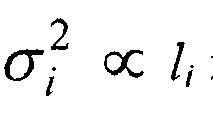
- Line segment length, l i is assumed to have zero mean Gaussian noise with variance ⁇ i 2 . That is, ⁇ i ⁇ N (0, ⁇ i 2 ).
- the matrix being inverted is 2 x 2, which is can be easily computed analytically for on-board real-time implementation.
- Loop detection can be used to not only to identify and close looping from one mobile robot 11 but also to find similarity between partial or completed maps determined by two or more different robots and merge the maps into one. Additionally, multiple smaller maps can be combined into a larger map by aligning the matching portions of the maps. Further, a map generated by the mobile robot can be compared or aligned against another, perhaps, larger, prior known map.
Landscapes
- Engineering & Computer Science (AREA)
- Radar, Positioning & Navigation (AREA)
- Aviation & Aerospace Engineering (AREA)
- Remote Sensing (AREA)
- Physics & Mathematics (AREA)
- General Physics & Mathematics (AREA)
- Automation & Control Theory (AREA)
- Control Of Position, Course, Altitude, Or Attitude Of Moving Bodies (AREA)
- Manipulator (AREA)
- Processing Or Creating Images (AREA)
Description
- This application relates in general to characterization of a physical environment by mobile robots and, in particular, to a system and method for real-time mapping of an indoor environment using mobile robots with limited sensing.
- Mapping of, and localization within, an environment is critical for efficient and effective robot exploration and navigation. Mapping is useful for identifying features of the environment that can increase or hinder the objectives of the mobile robot. For example, identification of corners or intersections of hallways within an indoor environment is useful for surveillance and networking applications. Additionally, knowledge of whether a robot has previously traversed an area aids in conservation of battery life and time efficiency.
- Mobile robots are often deployed in physical environments that are uncharted, remote, or inaccessible to conventional measuring techniques. To function most effectively, mobile robots need to discover the properties of the physical environment they are located in. Knowing details of the location can assist navigation, communication, and object retrieval or placement.
- Mapping the physical environment can help determine the size of the area explored by the robot, and, if the robot gets stuck or otherwise blocked by an obstacle, allows the robot to return to a known, higher value area. The identification of the physical environment also helps to determine whether the entire area has been traversed, what part of the area has provided better connectivity between the robot, and any additional robots, and users, as well as optimization of movement of the robot, which maximizes battery life and minimizes time of exploration.
- Generally, mobile robots use self-contained on-board guidance systems, which can include environmental sensors to track relative movement, detect collisions, identify obstructions, or provide an awareness of the immediate surroundings. Sensor readings are used to plan the next robotic movement or function to be performed. Movement can occur in a single direction or could be a sequence of individual movements, turns, and stationary positions.
- Conventional modes of mapping of a physical environment by robots include using a comprehensive sensor suite with long-range sensors, such as cameras, ultrasonic rangers, and light detection and ranging (LIDAR) to detect obstacles in front of, or surrounding, the robot. Long-range measurement of the environment has a large overhead, both economically due to the high cost of components, and efficiency, due to high power demands. Additionally, high-level computer cognitive models are used for environment mapping but incur a high computational overhead that often requires external, and time delayed, computation. These requirements for sensor-rich robots and powerful computation can be beyond the capabilities low-power robots with short-range sensors.
-
WO-A-03/040845 - Therefore, there is a need for an approach to on-board real-time mapping of an environment that is both cost-effective and efficient. Preferably, such an approach will be able to filter out errors created by sensor misreadings and obstacles within the physical environment.
- In accordance with a first aspect of the invention, a system for real-time mapping of an indoor environment using a mobile robot with short range sensing comprises:
- a segmentation module applying trace segmentation to raw trajectory data comprising a plurality of trajectory points from wall-following to generate line segments;
- a rectification module rectifying the line segments to one another; and
- a map module generating a map from the rectified line segments,
- and is characterized in that the rectification module is adapted to identify a history horizon of the current line segment, wherein the history horizon is a neighborhood of line segments within a distance of the current line segment, to identify a turning angle of each of the line segments based on the history horizon, and to rectify the line segments based on the line segments of the history horizon and the turning angle.
- In accordance with a second aspect of the present invention, a method for real-time mapping of an indoor environment using a mobile robot with short range sensing comprises:
- receiving raw trajectory data comprising a plurality of trajectory points from wall-following;
- applying trace segmentation to the raw trajectory data to generate line segments;
- rectifying the line segments to one another; and
- generating a map from the rectified line segments,
- and is characterized by identifying a history horizon of the current line segment, wherein the history horizon is a neighborhood of line segments within a distance of the current line segment, identifying a turning angle of each of the line segments based on the history horizon, and rectifying the line segments based on the line segments of the history horizon and the turning angle.
- Characteristics of a physical environment are determined based on data collected by a mobile robot. The mobile robot motion pattern and ongoing analysis of data received from sensors can be used for on-board real-time mapping of the environment by the mobile robot.
-
-
FIGURE 1 is a block diagram showing, by way of example, a representative physical environment for deployment of a mobile robot. -
FIGURE 2 is a flow diagram showing, by way of example, a method for real-time mapping of an indoor environment using mobile robots with limited sensing. -
FIGURE 3 is a flow diagram showing wall-following for use in the method ofFIGURE 2 . -
FIGURE 4 is a flow diagram showing trace segmentation for use in the method ofFIGURE 2 . -
FIGURE 5 is a flow diagram showing map rectification for use in the method ofFIGURE 2 . -
FIGURE 6 is a flow diagram showing loop detection and closure for use in the method ofFIGURE 2 . - A physical environment is mapped in real-time based on motion patterns of a mobile robot.
FIGURE 1 is a block diagram showing, by way of example, a representativephysical environment 10 for deployment of amobile robot 11. Thephysical environment 10 can include one ormore rooms 12 andhallways 13 separated by walls. Other components of thephysical environment 10 are possible. One or moremobile robots 11 can be deployed within thephysical environment 10. Additionally, one ormore obstructions 14, or obstacles, can be in theenvironment 10. - The
mobile robot 11 can include a power source, a communication interface to interface to other robots, base stations, and user nodes. The robot can also include motive power and a self-contained guidance system to move and guide the mobile robot about the environment, odometry to measure the distance traveled by, and position of, themobile robot 11 within the environment, a left bump sensor and, optionally, a right bump sensor, and a heading component to calculate the heading of the robot around a 360 degree axis extending longitudinally through the center of the robot. In a further embodiment, themobile robot 11 can include one or more short-range, such as infrared or ultrasonic, wall sensors for detection of an object, such as a wall, prior to the robot coming into physical contact with the object.Other robot 11 structures and components are possible. - The
robot 11 can also include an interface to a processor that can be implemented as an embedded micro-programmed system or as a general-purpose portable computer system, such as a notebook computer. The processor includes one or more modules for analyzing data gathered by the robot to characterize the physical environment in which the robot is deployed, as described herein. The processor is a programmable computing device that executes software programs and includes, for example, a central processing unit, memory, network interface, persistent storage, and various components for interconnecting these components. The modules can be implemented as a computer program or procedure written as source code in a conventional programming language and is presented for execution by the central processing unit as object or byte code. - Alternatively, the modules could also be implemented in hardware, either as integrated circuitry or burned into read-only memory components. The various implementations of the source code and object and byte codes can be held on a computer-readable storage medium, such as a floppy disk, hard drive, digital video disk (DVD), random access memory (RAM), read-only memory (ROM) and similar storage mediums. Other types of modules and module functions are possible, as well as other physical hardware components.
- In one embodiment, the data gathered is analyzed in real-time by the embedded, or on-board, processor and the output stored for later access in memory. In another embodiment, the output is stored on an external computer interfaced to by the
robot 11 through the network interface. In a still further embodiment, data collected frommultiple robots 11 is, grouped, analyzed, and compared in combination with one another. Other data analysis and storage combinations are possible. - Raw data collected by the
module robot 11 is analyzed to determine an environmental map in real-time.FIGURE 2 is a flow diagram showing, by way of example, a method for real-time mapping of an indoor environment using mobile robots with limited sensing. Therobot 11 moves around theenvironment 10 using a wall-following strategy (block 21), as further discussed below with reference toFIGURE 3 . Raw trajectory data, including distance traveled and turning angle is collected during the wall-following through the odometry. Further trajectory data can be collected from the wall sensor and bump sensors. The raw trajectory data is piecewise line fit using trace segmentation (block 22), as further discussed below with reference toFIGURE 4 . - The line segments are then rectified so that they are either parallel or perpendicular to one another (block 23), as further discussed below with reference to
FIGURE 5 . Optionally, any looping by themobile robot 11 over previously traversed areas is detected and the loop can then be closed (block 24), as further discussed below with reference toFIGURE 6 . Finally, the map is completed (block 25). - Wall-following allows complete traversal of the boundary of an environment during
robot 11 exploration. Additionally, regions previously traversed can be reached through reverse wall-following by travelling along the walls in the opposite direction than before without the need for accurate odometry.FIGURE 3 is a flow diagram showing wall-following for use in the method ofFIGURE 2 . Raw trajectory data, including distance traveled and orientation angle from odometry, wall sensor, and bumper sensor readings, are collected and stored during robot movement. Once introduced into an environment, data is collected by therobot 11 to determine if the wall sensor has detected a wall. - In one embodiment, a wall sensor located on the right side of the
robot 11 is used for wall-following. If no wall is detected, therobot 11 rotates clockwise until the wall sensor is triggered. If the wall sensor is not triggered after a full rotation therobot 11 moves in alinear direction 31 until one or both of the bump sensors detects an object through contact, assumed to be a wall, and is triggered. Once one of the bump sensors is triggered, therobot 11 rotates counterclockwise 32 until the bump sensor is no longer triggered and then follows, or tracks, thewall 33 using the wall sensor. - The odometry collects distance and orientation angle data on a regular basis. The robot frame of reference is determined based on an initial positioning, or pose, of the robot when deployed in the physical environment. Alternatively, the pose of the robot can be reset to the initial position at anytime prior to collecting odometry readings. For example, the initial, or starting, position of the robot can be set to (xo, yo, θ 0), where x and y are coordinates and θ is orientation and, initially, are set to 0. Any current position (xk, yk, θk), when odometry data is collected, can be calculated by xk = xk_ 1 + dcos(θk ), yk = y k-1 + dsin(θk), and θk = θk + a, where d and a are current distance and angle measurements from the last point where a measurement was made, respectively. Other positioning determinations are possible.
- Errors, or noise, in the odometry readings can occur due to quantization, such as errors in calculating orientation degree, and wheel slippage. Other sources of errors are possible. Distance errors are usually small while angle errors can be large due to roundoff and accumulator reset-when-read. For example, in one embodiment, the resolution of the sensors for distance is 0.001 meters and 1 °, or 0.0175 radians, for angle measurements. The measurements of distance and angle are reset to 0 after each reading. If sampling time for a reading is too small or in cases where the angles change slowly such that the angle movement is less than 1 ° between samples, the reading of angles would be 0 even though the real movements accumulated can be positive or negative. Increasing the sampling rate may cause other source of errors such as delay of response. Other resolutions are possible, though may be limited by digitization. Errors are corrected based on assumptions made about the external environment, as further discussed below beginning with reference to
FIGURE 4 . - Additionally, data is recorded from the left bumper (bl) and wall sensor (wr). When the left bump sensor is triggered, the bl reading is set to one, otherwise the reading is set to zero. A change in bump sensor reading from zero to one indicates the
robot 11 is likely turning left, or counterclockwise. The wall sensor reading, wr, is set to one when the sensor measurement is above an intensity threshold, indicating an obstacle, assumed to be a wall, close to the right side of therobot 11. If the measurement is below the threshold, the robot is likely not close to an obstacle on the right side and the wall sensor reading is set to zero. In a further embodiment, the wall sensor is located on the left side of therobot 11. The wall-following strategy is then reversed, for example, the rotation of the robot when no wall is detected by the wall sensor is counterclockwise. Other wall-following strategies are possible. - The bumper and wall sensor readings can be collected on a regular, periodic, or intermittent basis. In one embodiment, the sensors are polled at 20 Hz, and raw trajectories (x, y, bl, wr) are stored both at 1 Hz and whenever a state of the bump sensor or wall sensor changes. Other data collection frequencies are possible.
- Trace segmentation of collected data filters out common sensor errors and reduces computational overhead for mapping.
FIGURE 4 is a flow diagram showing trace segmentation for use in the method ofFIGURE 2 . During trace segmentation, raw trajectory data collected from the odometry, bump sensor, and wall sensor is piecewise line fit. The individual trajectory points are clustered into short linear segments. The line segments are then rectified into discrete rectilinear directions using a probabilistic approach, as further discussed below with reference toFIGURE 5 . Clustering individual data points into line segments greatly reduces computation complexity, and subsequently, computation overhead for the robot, because rectification is applied to a smaller number of line segments instead of a larger number of individual points. Additionally, trace segmentation can remove some of the measurement and control noise. Although wall-following can generate zigzag or curved trajectories due to fine control strategies and sensor noises, segmentation produces consecutive lines that outline the boundaries of obstacles. In most indoor environments, walls or obstacles are straight and therefore can be captured by such filters efficiently. - Line segments are generated using input trajectories over time. For example, input data {xk, yk, blk, wrk }k = 1, 2, ..., K, where (xk, yk ) is the location coordinate, and blk, and wrk are the left bumper and wall sensor readings, respectively, is used to generate output as line segment, represented by {li, θi , ti}, where l is length of a line segment, θ is orientation of the segment with respect to the robot's reference frame, in other words, the orientation with respect to the initial orientation, and t indicates whether the line segment has turned left, right, or is straight in reference to the previous line segment.
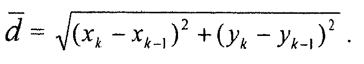
- Initially, a line segment is begun (block 41) using the first two trajectory data points collected. Length, l, is determined according to the equation


- Turns can be detected in a number of ways. The odometry, bump sensor, and wall sensor can provide information for determining a change in directions for the
robot 11. A change in bump sensor state, blk, occurs when the bump sensor is triggered through contact with an obstacle. The state is set to 0 when the bump sensor is not triggered. When the left bump sensor has a current reading of blk = 1, indicating bump sensor contact, and the previous data point, blk-1, was 0, then the robot has turned to the left and a new segment is begun, starting with blk, and t for the new segment is set to left. - When the wall sensor intensity is above a threshold value, the
robot 11 is following the wall. The state of the wall sensor is set to 1 when above the threshold and is 0 when the intensity is below the threshold. When wrk = 0 and wrk-1 = 1, the robot turns right in response to lost contact with the wall and t for the new segment is set to right. - Data collected through the odometry can be used to detect a change in direction as well. The distance from the current point to the current line segment is compared to the distance between the current point and previous points. The distance, dk, from the current point, (xk, Yk), to the current line segment is determined according to the equation dk = |cos(θ)(y k - yb ) - sin(θ)(x k - xb )l, where (xb, yb) is the beginning point of the current segment and θ is the orientation of the current segment, where θ = arctan(yk - yb, xk - xb ). The distance from the current point, (xk, yk ), to the previous point, (xk-1, yk-1 ), is determined according to the equation
- When dk ≧ κ
d , where κ is a constant between 0 and 1 that is a threshold for the minimum turning angle between segments, a new segment is created. Otherwise, the current segment is extended (block 43) to include the current point. In one embodiment, κ is set to 0.1. In a further embodiment, l, the length of the current segment, is compared to parameter L, which is a set minimum segment length. If l > L and dk ≥ κd , then a new segment is created. Otherwise, the current segment is extended to include the current point. In one embodiment, L is set to 0.7 meters but other minimum segment lengths are possible. When no further trajectory data is collected or once a turn is detected, the current segment is completed (block 45). Trace segmentation is applied to each additional trajectory data collected in real-time. - Trace segmentation produces line segments that fit to the trajectory of the wall-following of the
robot 11 but due to odometry errors, the trajectories can be deformed due to measurement noise. Rectification corrects the deformations by making the line segments either parallel or perpendicular to one another.FIGURE 5 is a flow diagram showing map rectification for use in the method ofFIGURE 2 . Many indoor environments are rectilinear with perpendicular walls and the rectilinear interior can be used to correct noise in the line segments. The input of the rectification is a sequence of line segments (l i, θi, ti ) generated from trace segmentation, and the output is a new sequence of line segments (li , si), where s is the rectified angle. A constraint is applied so that any two neighboring segments are either aligned or rectilinear. Once rectified, each segment is a multiple of /π2 from one another. - In one embodiment, the turning angle between two neighboring segments is examined and classified into discrete angles, for example, 0°, 90°, and so on using a straight-forward classification algorithm. A turning angle smaller than a threshold, for example, 45°, is classified as 0°, or straight, otherwise the turning angle is classified as a rectilinear turn. But this classification algorithm can be problematic in some instances. For example, in the case of four line segments, with direction θi = 0°, 30°, 60°, and 90°, respectively, the turning angle between any two concurrent segments is only 30°, hence the straight-forward classification algorithm will classify each turning angle as 0°. However, the robot has actually finished a 90° turn. This problem can be fixed by extending the classification from the stateless classification of instantaneous turning angles described above to a state-based classification with turning angle history.
- In a further embodiment, each line segment is rectified using not only the turning angle of the particular line segment but also a history horizon of previous line segments turning angles (block 51). For a line segment, i, the turning angle of the segment along with the history { i - 1, i - 2,. , i - H} is considered, where H is the horizon length. The horizon length is the number of previous line segments that are taken into consideration to determine the turning angle of the current line segment and can be defined in a number of ways. For example, the horizon length can be the line segments within a physical distance, such as five meters, of the current segment. Alternatively, the horizon length can be defined as a set number of line segments prior to the current line segment. Other types of horizon lengths are possible. In any case, the line segments within the horizon are collectively considered to rectify the current line segment and can avoid the problems with the stateless classification described above. Furthermore, use of the history horizon can remove noisy data and provide move accurate mapping in the presence of obstacles when the obstacles are small in size compared to the history horizon since the line segments before and after the obstacle are used for rectification.
- Next, the probability of the orientation of the current segment is described (block 52). In one embodiment, approximate sequential Bayesian filtering is used to recursively update an estimate of the posterior of underlying state S i+l with observation sequences
z i+1 = {z 0, z 1,..., z i+1} and given by the equation:
- Equation (1) is sequential, the belief p(s i+1|
z i+1 ) is computed from the belief p(si |zi ) from the previous time i at each step. The integral in Equation (1) is a single step of prediction bringing the previous state si up to the current time s i+l and then a new external measurement z i+1 is applied to modify the state. The prediction is then multiplied by a likelihood, reflecting the contribution of observation z i+1 using an observation model, po (z i+1|s i+1). - Two key components that are essential in the sequential Bayesian filtering approach are the dynamics model, pd (s i+1|si ), and the observation model, Po(zls).
- The dynamics model describes the evolution, or drifting, of the underlying state. Here, si is the orientation directions {s¡, s i+ 1,..., si-H }. Since the line segments defining the walls are assumed rectilinear, or to intersect each other at perpendicular angles, the model is given by the equation:

- Although the above particular probability distribution is used, other distributions are possible. For example, the above model can be extended to eight directions instead of four for environments that have many 45 degree angles.
- Next, the observation model describes the relationship between the underlying states and measurement observations. The measurements of turning angle θ from the odometry are used over the history horizon, where z = {θi , θi-1 , .. . θi-H }. An assumption is made that the measured turning angle is the true turning angle but is contaminated with noise, for example, θ i+1 -θi-j = si, - si-j, + nj , where j indicates the j-th previous segment and nj is noise.
- In one embodiment, a generalized Gaussian distribution (GGD) is used as a model for the noise. Though, other noise models are possible. The GGD is parameterized by a shape parameter, r°, and a standard deviation, σ. In a further embodiment, GGD includes Gaussian distributions as a special case, when r = 2, but is more flexible because the shape parameter r can be varied to describe noise with heavy tails (when r < 2). This can be necessary for modeling angle noise because odometry data can be quite noisy, especially when the line segment length is short. For example, when a
robot 11 is almost stationary, any angle measurement from odometry is possible, in other words, θ = arctan(y 2 - y1 , x2 -x1 ) is arbitrary when the distance between (x1,y1 ) and (x2,y2 ) is very small or approaching zero. In one embodiment, a shape parameter, where r = 0.5 and a standard deviation of 10° for n1, and (H - 1).20° for nj where 1 <j < H are used. Other shape parameter and standard deviation amounts are possible. - In a further embodiment, the turn information, where t = {STRAIGHT, LEFT, RIGHT}, obtained from trace segmentation, as described above with reference to
FIGURE 3 , is used in rectification. A simple likelihood function, p(t|s) = 1, is applied if the turn state in the hypothesis determined above agrees with the turn observation t, and p(t|s) = 0.5 if the two do not agree. Hypotheses are discounted, such as by half, that conflict with sensor observations. The observation likelihood is multiplied to that of the odometry data, assuming that the different sensing modalities are independent of one another, since an assumption is made that odometry error is independent to bumper and wall sensor error. - The rectification process then takes the line segment inputs over time and maintains up to N, for example, 100, of the most probable state sequences and their respective probabilities pn . Whenever a new line segment (l, θ, t) is determined (block 53), each existing state sequence (s 0, s 1, ... si ) forks into four possibilities, with the new traveling direction s i+1 being straight, a left turn, a right turn, or a U-turn. Probabilities of the new state sequences are updated using the dynamics model and observation model as described above. State sequences with low probabilities (pn < 1/N) are discarded, and up to N most probable state sequences are kept, the probabilities are then renormalized to sum up to 1 by pn ← pn /P and P is ∑ pn , which leads up to the next update when a new segment is determined. The final mapping result is the most probable state sequence (block 54).
- Detecting whether the
robot 11 is looping around the environment by traversal over the same area is important to conserve time and efficient power usage. If looping is detected, therobot 11 may cease further movement or migrate to previously unexplored areas.FIGURE 6 is a flow diagram showing loop detection and closure for use in the method ofFIGURE 2 . Since the environment map is generated from line segments, the map can be represented (block 61) by a one-dimensional function. In one embodiment, the function is represented as s(d), where d is the traveled distance from therobot 11 starting position, or point, and s(d) is the wall orientation at that point. - In a further embodiment, s can be accumulated turn counts (ATC) at a particular distance from the staring position. For example, a left turn can be assigned a value of I, while a right turn is assigned a value of-1. ATC is the sum of all turns up to the current point. High positive or low negative, such as ≥ 10 or ≤-10, ATC counts can indicate a loop. ATC counts of 4 or -4 indicate a complete left or right circle. Other values for s are possible.
- In any event, wall orientation θ, is then s . π/2. Loop detection is performed whenever a new segment (l, θ, t) is rectified. In particular, if the location of the first corner of the rectified map is (x 1, y 1), and there are already (x 0, y 0) ,(x 1, y 1), (x2, y 2), ......, (x m, y m) points in the map, a loop is detected (block 62) at (lm+1, s m+1) if the following three conditions are satisfied:
- 1) sm = 2π or sm = -2π, in other words, a full turn around in angles by the robot 1!;
- 2) s m+1≠ sm, in other words, a corner at turn around; and
- 3)

- In some structures, loop detection can be difficult or even fail due to odometry error or error introduced by mapping, for example, linearization of curved wall segments or rectification of non-rectilinear segments. In a further embodiment, autocorrelation in the rectified segment sequence can be determined to find the corresponding matching points. When the
robot 11 is looping while wall-following, the sequence s(d) may appear repetitive, for example, a portion of the sequence can be similar to another portion of the sequence. Such similarities can be detected via signal correlation. Even though therobot 11 may initially miss the closing point, therobot 11 can identify the closing point after detecting the autocorrelation in the rectified segment sequence. In particular, if there is a loop in s1 , s2 , ..., s m , s m+1 ..., the sequence starting from sm would be similar to that from s1 . - Once segment correspondence is determined in a loop, the lengths of the line segments are adjusted (block 63) by subtracting estimated error, Δ ¡, from li for each segment i to close the loop (block 64) at the first overlapping corner at the end of segment m. Maximum likelihood estimation is used to find Δ = [Δ1 Δ m ] T . The estimated orientation of the segments remains unchanged. Line segment length, li, is assumed to have zero mean Gaussian noise with variance


- If


- By defining


where is the Hadamard (element-wise) product, θ = [θ1 ... θm ]T, and σ = [σ1 ... σm ]T. The solution is then given by


- Note that the matrix being inverted is 2 x 2, which is can be easily computed analytically for on-board real-time implementation.
- Loop detection can be used to not only to identify and close looping from one
mobile robot 11 but also to find similarity between partial or completed maps determined by two or more different robots and merge the maps into one. Additionally, multiple smaller maps can be combined into a larger map by aligning the matching portions of the maps. Further, a map generated by the mobile robot can be compared or aligned against another, perhaps, larger, prior known map.
Claims (13)
- A system for real-time mapping of an indoor environment using a mobile robot with short range sensing, comprising:a segmentation module applying trace segmentation to raw trajectory data comprising a plurality of trajectory points from wall-following to generate line segments;a rectification module rectifying the line segments to one another; anda map module generating a map from the rectified line segments,characterized in that the rectification module is adapted to identify a history horizon of the current line segment, wherein the history horizon is a neighborhood of line segments within a distance of the current line segment, to identify (51) a turning angle of each of the line segments based on the history horizon, and to rectify the line segments based on the line segments of the history horizon and the turning angle.
- A system according to claim 1, further comprising:a line segment module generating an initial line segment with two of the trajectory points and extending the line segment through each of the next trajectory points until a turn is detected, for example through a change in one of a bump sensor state, a wall sensor state, and odometry.
- A system according to claim 1 or claim 2, further comprising a robot for generating the raw trajectory data.
- A system according to any of the preceding claims, further comprising:a constraint module applying a constraint so any two neighboring line segments are one of aligned or rectilinear to one another.
- A system according to any of the preceding claims, further comprising:a probability module determining a plurality of probabilities of a current direction of the current line segment and each of the line segments of the history horizon and completing the map using the most probable direction for each of the line segments.
- A system according to any of the preceding claims, further comprising:a representation module representing the map as a one-dimensional function;a loop module detecting a loop comprising overlapping line segment within the map ;an error module adjusting line segment length of the overlapping line segments by an estimated error; anda closure module closing the loop at the intersection of the adjusted line segments.
- A method for real-time mapping of an indoor environment using a mobile robot with short range sensing, comprising:receiving raw trajectory data comprising a plurality of trajectory points from wall-following;applying trace segmentation (22) to the raw trajectory data to generate line segments;rectifying (23) the line segments to one another; andgenerating (25) a map from the rectified line segments,characterized by identifying a history horizon of the current line segment, wherein the history horizon is a neighborhood of line segments within a distance of the current line segment, identifying (51) a turning angle of each of the line segments based on the history horizon, and rectifying the line segments based on the line segments of the history horizon and the turning angle.
- A method according to claim 7, further comprising:generating (41) an initial line segment with two of the trajectory points; andextending (43) the line segment through each of the next trajectory points until a turn is detected, wherein the turn is preferably detected through a change in one of a bump sensor state, a wall sensor state, and odometry.
- A method according to claim 7 or claim 8 wherein the raw trajectory data is generated by a robot.
- A method according to any of claims 7 to 9, further comprising applying a constraint so any two neighboring line segments are one of aligned or rectilinear to one another.
- A method according to any of claims 7 to 10, wherein the line segments are rectified according to the equation:

where p is probability of a rectified sequence given the sequence of measurements, s is state, in this case, orientation of a segment, z is observation, including both odometry and sensor observations, p(s i+1|z i+1 ) is computed from the belief p(si |zi ) from the previous time, i, at each step, z i+1 is observation, p o(z i+1|s i+1), p o(z|s) is an observation model, pd (s i+1|si ) is a dynamics model, θ is turning angle, where z = {θ i , θi-1 , ... θi-H }, and H is a history horizon. - A method according to any of claims 7 to 11, further comprising:determining a plurality of probabilities of a current direction of the current line segment and each of the line segments of the history horizon ;completing the map using the most probable direction for each of the line segments.
- A method according to any of claims 7 to 12, further comprising:representing the map as a one-dimensional function;detecting a loop comprising overlapping line segment within the map ;adjusting line segment length of the overlapping line segments by an estimated error; andclosing the loop at the intersection of the adjusted line segments.
Applications Claiming Priority (1)
| Application Number | Priority Date | Filing Date | Title |
|---|---|---|---|
| US12/841,065 US20120195491A1 (en) | 2010-07-21 | 2010-07-21 | System And Method For Real-Time Mapping Of An Indoor Environment Using Mobile Robots With Limited Sensing |
Publications (3)
| Publication Number | Publication Date |
|---|---|
| EP2410395A2 EP2410395A2 (en) | 2012-01-25 |
| EP2410395A3 EP2410395A3 (en) | 2012-11-28 |
| EP2410395B1 true EP2410395B1 (en) | 2014-09-10 |
Family
ID=44533833
Family Applications (1)
| Application Number | Title | Priority Date | Filing Date |
|---|---|---|---|
| EP11172641.0A Not-in-force EP2410395B1 (en) | 2010-07-21 | 2011-07-05 | System and method for real-time mapping of an indoor environment using mobile robots with limited sensing |
Country Status (3)
| Country | Link |
|---|---|
| US (1) | US20120195491A1 (en) |
| EP (1) | EP2410395B1 (en) |
| JP (1) | JP5820168B2 (en) |
Families Citing this family (14)
| Publication number | Priority date | Publication date | Assignee | Title |
|---|---|---|---|---|
| DE102011111342B3 (en) * | 2011-05-31 | 2012-12-06 | Deutsches Zentrum für Luft- und Raumfahrt e.V. | Method for determining the position of moving objects |
| US9177404B2 (en) | 2012-10-31 | 2015-11-03 | Qualcomm Incorporated | Systems and methods of merging multiple maps for computer vision based tracking |
| US8983774B2 (en) * | 2013-07-09 | 2015-03-17 | Qualcomm Incorporated | Intelligent map combination for venues enabling indoor positioning |
| US9380425B2 (en) | 2013-12-05 | 2016-06-28 | At&T Mobility Ii Llc | Systems, methods, and computer-readable storage devices for generating and using a radio-frequency map of an area |
| US9195906B2 (en) | 2014-03-10 | 2015-11-24 | Google Inc. | Region extraction from occupancy grids |
| EP3234626A4 (en) * | 2014-12-18 | 2018-08-22 | Innerspace Technology Inc. | Method and system for sensing interior spaces to auto-generate a navigational map |
| CN105511742B (en) * | 2016-01-07 | 2021-10-01 | 美国西北仪器公司 | Intelligent interactive interface |
| US11243309B2 (en) | 2015-02-16 | 2022-02-08 | Northwest Instrument Inc. | Ranging system and ranging method |
| CN105094135A (en) * | 2015-09-03 | 2015-11-25 | 上海电机学院 | Distributed multi-robot map fusion system and fusion method |
| US11556170B2 (en) | 2016-01-07 | 2023-01-17 | Northwest Instrument Inc. | Intelligent interface based on augmented reality |
| US9864377B2 (en) * | 2016-04-01 | 2018-01-09 | Locus Robotics Corporation | Navigation using planned robot travel paths |
| CN109343544B (en) * | 2018-12-19 | 2021-06-04 | 武汉科技大学 | Mobile robot wall-following efficient traversal algorithm combined with historical state |
| CN111006652B (en) * | 2019-12-20 | 2023-08-01 | 深圳市飞瑶电机科技有限公司 | Robot side-by-side operation method |
| CN116303479B (en) * | 2023-05-22 | 2023-08-22 | 浙大宁波理工学院 | Real-time compression method for track data |
Family Cites Families (19)
| Publication number | Priority date | Publication date | Assignee | Title |
|---|---|---|---|---|
| JP2501010B2 (en) * | 1993-10-25 | 1996-05-29 | インターナショナル・ビジネス・マシーンズ・コーポレイション | Mobile robot guidance device |
| JPH10260724A (en) * | 1997-03-19 | 1998-09-29 | Yaskawa Electric Corp | Map generating method for passage environment |
| US6374155B1 (en) * | 1999-11-24 | 2002-04-16 | Personal Robotics, Inc. | Autonomous multi-platform robot system |
| JP2002287824A (en) * | 2001-03-26 | 2002-10-04 | Toshiba Tec Corp | Autonomous traveling robot |
| US7663333B2 (en) * | 2001-06-12 | 2010-02-16 | Irobot Corporation | Method and system for multi-mode coverage for an autonomous robot |
| GB0126497D0 (en) * | 2001-11-03 | 2002-01-02 | Dyson Ltd | An autonomous machine |
| SE0200197L (en) * | 2002-01-23 | 2003-07-24 | Electrolux Ab | Procedure for a device on wheels |
| JP2004139266A (en) * | 2002-10-16 | 2004-05-13 | Toshiba Tec Corp | Autonomous traveling robot |
| US7706917B1 (en) * | 2004-07-07 | 2010-04-27 | Irobot Corporation | Celestial navigation system for an autonomous robot |
| EP1920326A4 (en) * | 2005-09-02 | 2014-01-08 | Neato Robotics Inc | Multi-function robotic device |
| US7539557B2 (en) * | 2005-12-30 | 2009-05-26 | Irobot Corporation | Autonomous mobile robot |
| EP2013671B1 (en) * | 2006-03-17 | 2018-04-25 | iRobot Corporation | Lawn care robot |
| US7587260B2 (en) * | 2006-07-05 | 2009-09-08 | Battelle Energy Alliance, Llc | Autonomous navigation system and method |
| JP5016399B2 (en) * | 2007-06-08 | 2012-09-05 | パナソニック株式会社 | Map information creation device and autonomous mobile device equipped with the map information creation device |
| SG183690A1 (en) * | 2007-08-06 | 2012-09-27 | Trx Systems Inc | Locating, tracking, and/or monitoring personnel and/or assets both indoors and outdoors |
| KR101457148B1 (en) * | 2008-05-21 | 2014-10-31 | 삼성전자 주식회사 | Apparatus for localizing moving robot and method the same |
| US8340818B2 (en) * | 2009-04-24 | 2012-12-25 | Robert Bosch Gmbh | Method of accurate mapping with mobile robots |
| US8306732B2 (en) * | 2009-08-18 | 2012-11-06 | Palo Alto Research Center Incorporated | Model based method to assess road curvature effect on travel time and comfort for route planning |
| CA2859112C (en) * | 2009-08-31 | 2017-08-15 | Neato Robotics, Inc. | Method and apparatus for simultaneous localization and mapping of mobile robot environment |
-
2010
- 2010-07-21 US US12/841,065 patent/US20120195491A1/en not_active Abandoned
-
2011
- 2011-07-05 EP EP11172641.0A patent/EP2410395B1/en not_active Not-in-force
- 2011-07-08 JP JP2011152201A patent/JP5820168B2/en not_active Expired - Fee Related
Also Published As
| Publication number | Publication date |
|---|---|
| EP2410395A2 (en) | 2012-01-25 |
| US20120195491A1 (en) | 2012-08-02 |
| JP2012212412A (en) | 2012-11-01 |
| JP5820168B2 (en) | 2015-11-24 |
| EP2410395A3 (en) | 2012-11-28 |
Similar Documents
| Publication | Publication Date | Title |
|---|---|---|
| EP2410395B1 (en) | System and method for real-time mapping of an indoor environment using mobile robots with limited sensing | |
| Röhling et al. | A fast histogram-based similarity measure for detecting loop closures in 3-d lidar data | |
| CN103472823B (en) | A kind of grating map creating method of intelligent robot | |
| Xiao et al. | Monocular vehicle self-localization method based on compact semantic map | |
| CN113330279A (en) | Method and system for determining the position of a vehicle | |
| Zhang et al. | Real-time indoor mapping for mobile robots with limited sensing | |
| US11143511B2 (en) | On-vehicle processing device | |
| Tsiakas et al. | Autonomous vehicle navigation in semi-structured environments based on sparse waypoints and LiDAR road-tracking | |
| Xu et al. | Dynamic vehicle pose estimation and tracking based on motion feedback for LiDARs | |
| Wu et al. | Infrastructure-free global localization in repetitive environments: An overview | |
| US20220155455A1 (en) | Method and system for ground surface projection for autonomous driving | |
| Wang et al. | A clutter-resistant SLAM algorithm for autonomous guided vehicles in dynamic industrial environment | |
| Ko et al. | A scene-based dependable indoor navigation system | |
| Chen et al. | Appearance-based topological Bayesian inference for loop-closing detection in a cross-country environment | |
| AU2021273605B2 (en) | Multi-agent map generation | |
| US8457829B2 (en) | System and method for determining characteristics of a physical environment with simple motion patterns | |
| Bopardikar et al. | Robust belief roadmap: Planning under uncertain and intermittent sensing | |
| Watanabe et al. | Robust localization with architectural floor plans and depth camera | |
| ElKaissi et al. | SEDLRF: A new door detection system for topological maps | |
| Shen et al. | Spatio-temporal motion features for laser-based moving objects detection and tracking | |
| Maziarz et al. | Customized fastSLAM algorithm: Analysis and assessment on real mobile platform | |
| Burger et al. | Map-Aware SLAM with Sparse Map Features | |
| Lorenzo et al. | A Hough-based method for concurrent mapping and localization in indoor environments | |
| Jensen et al. | Motion detection and path planning in dynamic environments | |
| Lee et al. | Probabilistic localization of the service robot by map matching algorithm |
Legal Events
| Date | Code | Title | Description |
|---|---|---|---|
| AK | Designated contracting states |
Kind code of ref document: A2 Designated state(s): AL AT BE BG CH CY CZ DE DK EE ES FI FR GB GR HR HU IE IS IT LI LT LU LV MC MK MT NL NO PL PT RO RS SE SI SK SM TR |
|
| AX | Request for extension of the european patent |
Extension state: BA ME |
|
| PUAI | Public reference made under article 153(3) epc to a published international application that has entered the european phase |
Free format text: ORIGINAL CODE: 0009012 |
|
| PUAL | Search report despatched |
Free format text: ORIGINAL CODE: 0009013 |
|
| AK | Designated contracting states |
Kind code of ref document: A3 Designated state(s): AL AT BE BG CH CY CZ DE DK EE ES FI FR GB GR HR HU IE IS IT LI LT LU LV MC MK MT NL NO PL PT RO RS SE SI SK SM TR |
|
| AX | Request for extension of the european patent |
Extension state: BA ME |
|
| RIC1 | Information provided on ipc code assigned before grant |
Ipc: G05D 1/02 20060101AFI20121019BHEP |
|
| 17P | Request for examination filed |
Effective date: 20130528 |
|
| RBV | Designated contracting states (corrected) |
Designated state(s): AL AT BE BG CH CY CZ DE DK EE ES FI FR GB GR HR HU IE IS IT LI LT LU LV MC MK MT NL NO PL PT RO RS SE SI SK SM TR |
|
| GRAP | Despatch of communication of intention to grant a patent |
Free format text: ORIGINAL CODE: EPIDOSNIGR1 |
|
| INTG | Intention to grant announced |
Effective date: 20140515 |
|
| GRAS | Grant fee paid |
Free format text: ORIGINAL CODE: EPIDOSNIGR3 |
|
| GRAA | (expected) grant |
Free format text: ORIGINAL CODE: 0009210 |
|
| AK | Designated contracting states |
Kind code of ref document: B1 Designated state(s): AL AT BE BG CH CY CZ DE DK EE ES FI FR GB GR HR HU IE IS IT LI LT LU LV MC MK MT NL NO PL PT RO RS SE SI SK SM TR |
|
| REG | Reference to a national code |
Ref country code: GB Ref legal event code: FG4D |
|
| REG | Reference to a national code |
Ref country code: CH Ref legal event code: EP |
|
| REG | Reference to a national code |
Ref country code: IE Ref legal event code: FG4D |
|
| REG | Reference to a national code |
Ref country code: AT Ref legal event code: REF Ref document number: 686995 Country of ref document: AT Kind code of ref document: T Effective date: 20141015 |
|
| REG | Reference to a national code |
Ref country code: DE Ref legal event code: R096 Ref document number: 602011009752 Country of ref document: DE Effective date: 20141023 |
|
| PG25 | Lapsed in a contracting state [announced via postgrant information from national office to epo] |
Ref country code: LT Free format text: LAPSE BECAUSE OF FAILURE TO SUBMIT A TRANSLATION OF THE DESCRIPTION OR TO PAY THE FEE WITHIN THE PRESCRIBED TIME-LIMIT Effective date: 20140910 Ref country code: NO Free format text: LAPSE BECAUSE OF FAILURE TO SUBMIT A TRANSLATION OF THE DESCRIPTION OR TO PAY THE FEE WITHIN THE PRESCRIBED TIME-LIMIT Effective date: 20141210 Ref country code: FI Free format text: LAPSE BECAUSE OF FAILURE TO SUBMIT A TRANSLATION OF THE DESCRIPTION OR TO PAY THE FEE WITHIN THE PRESCRIBED TIME-LIMIT Effective date: 20140910 Ref country code: SE Free format text: LAPSE BECAUSE OF FAILURE TO SUBMIT A TRANSLATION OF THE DESCRIPTION OR TO PAY THE FEE WITHIN THE PRESCRIBED TIME-LIMIT Effective date: 20140910 Ref country code: GR Free format text: LAPSE BECAUSE OF FAILURE TO SUBMIT A TRANSLATION OF THE DESCRIPTION OR TO PAY THE FEE WITHIN THE PRESCRIBED TIME-LIMIT Effective date: 20141211 Ref country code: ES Free format text: LAPSE BECAUSE OF FAILURE TO SUBMIT A TRANSLATION OF THE DESCRIPTION OR TO PAY THE FEE WITHIN THE PRESCRIBED TIME-LIMIT Effective date: 20140910 |
|
| REG | Reference to a national code |
Ref country code: NL Ref legal event code: VDEP Effective date: 20140910 |
|
| REG | Reference to a national code |
Ref country code: LT Ref legal event code: MG4D |
|
| PG25 | Lapsed in a contracting state [announced via postgrant information from national office to epo] |
Ref country code: CY Free format text: LAPSE BECAUSE OF FAILURE TO SUBMIT A TRANSLATION OF THE DESCRIPTION OR TO PAY THE FEE WITHIN THE PRESCRIBED TIME-LIMIT Effective date: 20140910 Ref country code: LV Free format text: LAPSE BECAUSE OF FAILURE TO SUBMIT A TRANSLATION OF THE DESCRIPTION OR TO PAY THE FEE WITHIN THE PRESCRIBED TIME-LIMIT Effective date: 20140910 Ref country code: RS Free format text: LAPSE BECAUSE OF FAILURE TO SUBMIT A TRANSLATION OF THE DESCRIPTION OR TO PAY THE FEE WITHIN THE PRESCRIBED TIME-LIMIT Effective date: 20140910 Ref country code: HR Free format text: LAPSE BECAUSE OF FAILURE TO SUBMIT A TRANSLATION OF THE DESCRIPTION OR TO PAY THE FEE WITHIN THE PRESCRIBED TIME-LIMIT Effective date: 20140910 |
|
| REG | Reference to a national code |
Ref country code: AT Ref legal event code: MK05 Ref document number: 686995 Country of ref document: AT Kind code of ref document: T Effective date: 20140910 |
|
| PG25 | Lapsed in a contracting state [announced via postgrant information from national office to epo] |
Ref country code: NL Free format text: LAPSE BECAUSE OF FAILURE TO SUBMIT A TRANSLATION OF THE DESCRIPTION OR TO PAY THE FEE WITHIN THE PRESCRIBED TIME-LIMIT Effective date: 20140910 |
|
| PG25 | Lapsed in a contracting state [announced via postgrant information from national office to epo] |
Ref country code: SK Free format text: LAPSE BECAUSE OF FAILURE TO SUBMIT A TRANSLATION OF THE DESCRIPTION OR TO PAY THE FEE WITHIN THE PRESCRIBED TIME-LIMIT Effective date: 20140910 Ref country code: EE Free format text: LAPSE BECAUSE OF FAILURE TO SUBMIT A TRANSLATION OF THE DESCRIPTION OR TO PAY THE FEE WITHIN THE PRESCRIBED TIME-LIMIT Effective date: 20140910 Ref country code: CZ Free format text: LAPSE BECAUSE OF FAILURE TO SUBMIT A TRANSLATION OF THE DESCRIPTION OR TO PAY THE FEE WITHIN THE PRESCRIBED TIME-LIMIT Effective date: 20140910 Ref country code: PT Free format text: LAPSE BECAUSE OF FAILURE TO SUBMIT A TRANSLATION OF THE DESCRIPTION OR TO PAY THE FEE WITHIN THE PRESCRIBED TIME-LIMIT Effective date: 20150112 Ref country code: IS Free format text: LAPSE BECAUSE OF FAILURE TO SUBMIT A TRANSLATION OF THE DESCRIPTION OR TO PAY THE FEE WITHIN THE PRESCRIBED TIME-LIMIT Effective date: 20150110 Ref country code: RO Free format text: LAPSE BECAUSE OF FAILURE TO SUBMIT A TRANSLATION OF THE DESCRIPTION OR TO PAY THE FEE WITHIN THE PRESCRIBED TIME-LIMIT Effective date: 20140910 |
|
| PG25 | Lapsed in a contracting state [announced via postgrant information from national office to epo] |
Ref country code: AT Free format text: LAPSE BECAUSE OF FAILURE TO SUBMIT A TRANSLATION OF THE DESCRIPTION OR TO PAY THE FEE WITHIN THE PRESCRIBED TIME-LIMIT Effective date: 20140910 Ref country code: PL Free format text: LAPSE BECAUSE OF FAILURE TO SUBMIT A TRANSLATION OF THE DESCRIPTION OR TO PAY THE FEE WITHIN THE PRESCRIBED TIME-LIMIT Effective date: 20140910 |
|
| REG | Reference to a national code |
Ref country code: DE Ref legal event code: R097 Ref document number: 602011009752 Country of ref document: DE |
|
| PLBE | No opposition filed within time limit |
Free format text: ORIGINAL CODE: 0009261 |
|
| STAA | Information on the status of an ep patent application or granted ep patent |
Free format text: STATUS: NO OPPOSITION FILED WITHIN TIME LIMIT |
|
| PG25 | Lapsed in a contracting state [announced via postgrant information from national office to epo] |
Ref country code: DK Free format text: LAPSE BECAUSE OF FAILURE TO SUBMIT A TRANSLATION OF THE DESCRIPTION OR TO PAY THE FEE WITHIN THE PRESCRIBED TIME-LIMIT Effective date: 20140910 |
|
| 26N | No opposition filed |
Effective date: 20150611 |
|
| PG25 | Lapsed in a contracting state [announced via postgrant information from national office to epo] |
Ref country code: IT Free format text: LAPSE BECAUSE OF FAILURE TO SUBMIT A TRANSLATION OF THE DESCRIPTION OR TO PAY THE FEE WITHIN THE PRESCRIBED TIME-LIMIT Effective date: 20140910 |
|
| PG25 | Lapsed in a contracting state [announced via postgrant information from national office to epo] |
Ref country code: SI Free format text: LAPSE BECAUSE OF FAILURE TO SUBMIT A TRANSLATION OF THE DESCRIPTION OR TO PAY THE FEE WITHIN THE PRESCRIBED TIME-LIMIT Effective date: 20140910 |
|
| PG25 | Lapsed in a contracting state [announced via postgrant information from national office to epo] |
Ref country code: MC Free format text: LAPSE BECAUSE OF FAILURE TO SUBMIT A TRANSLATION OF THE DESCRIPTION OR TO PAY THE FEE WITHIN THE PRESCRIBED TIME-LIMIT Effective date: 20140910 |
|
| REG | Reference to a national code |
Ref country code: CH Ref legal event code: PL |
|
| PG25 | Lapsed in a contracting state [announced via postgrant information from national office to epo] |
Ref country code: LU Free format text: LAPSE BECAUSE OF FAILURE TO SUBMIT A TRANSLATION OF THE DESCRIPTION OR TO PAY THE FEE WITHIN THE PRESCRIBED TIME-LIMIT Effective date: 20150705 |
|
| REG | Reference to a national code |
Ref country code: IE Ref legal event code: MM4A |
|
| PG25 | Lapsed in a contracting state [announced via postgrant information from national office to epo] |
Ref country code: CH Free format text: LAPSE BECAUSE OF NON-PAYMENT OF DUE FEES Effective date: 20150731 Ref country code: LI Free format text: LAPSE BECAUSE OF NON-PAYMENT OF DUE FEES Effective date: 20150731 |
|
| REG | Reference to a national code |
Ref country code: FR Ref legal event code: PLFP Year of fee payment: 6 |
|
| PG25 | Lapsed in a contracting state [announced via postgrant information from national office to epo] |
Ref country code: IE Free format text: LAPSE BECAUSE OF NON-PAYMENT OF DUE FEES Effective date: 20150705 Ref country code: BE Free format text: LAPSE BECAUSE OF FAILURE TO SUBMIT A TRANSLATION OF THE DESCRIPTION OR TO PAY THE FEE WITHIN THE PRESCRIBED TIME-LIMIT Effective date: 20140910 |
|
| PG25 | Lapsed in a contracting state [announced via postgrant information from national office to epo] |
Ref country code: MT Free format text: LAPSE BECAUSE OF FAILURE TO SUBMIT A TRANSLATION OF THE DESCRIPTION OR TO PAY THE FEE WITHIN THE PRESCRIBED TIME-LIMIT Effective date: 20140910 |
|
| PG25 | Lapsed in a contracting state [announced via postgrant information from national office to epo] |
Ref country code: HU Free format text: LAPSE BECAUSE OF FAILURE TO SUBMIT A TRANSLATION OF THE DESCRIPTION OR TO PAY THE FEE WITHIN THE PRESCRIBED TIME-LIMIT; INVALID AB INITIO Effective date: 20110705 Ref country code: SM Free format text: LAPSE BECAUSE OF FAILURE TO SUBMIT A TRANSLATION OF THE DESCRIPTION OR TO PAY THE FEE WITHIN THE PRESCRIBED TIME-LIMIT Effective date: 20140910 Ref country code: BG Free format text: LAPSE BECAUSE OF FAILURE TO SUBMIT A TRANSLATION OF THE DESCRIPTION OR TO PAY THE FEE WITHIN THE PRESCRIBED TIME-LIMIT Effective date: 20140910 |
|
| REG | Reference to a national code |
Ref country code: FR Ref legal event code: PLFP Year of fee payment: 7 |
|
| PG25 | Lapsed in a contracting state [announced via postgrant information from national office to epo] |
Ref country code: TR Free format text: LAPSE BECAUSE OF FAILURE TO SUBMIT A TRANSLATION OF THE DESCRIPTION OR TO PAY THE FEE WITHIN THE PRESCRIBED TIME-LIMIT Effective date: 20140910 |
|
| REG | Reference to a national code |
Ref country code: FR Ref legal event code: PLFP Year of fee payment: 8 |
|
| PG25 | Lapsed in a contracting state [announced via postgrant information from national office to epo] |
Ref country code: MK Free format text: LAPSE BECAUSE OF FAILURE TO SUBMIT A TRANSLATION OF THE DESCRIPTION OR TO PAY THE FEE WITHIN THE PRESCRIBED TIME-LIMIT Effective date: 20140910 |
|
| PGFP | Annual fee paid to national office [announced via postgrant information from national office to epo] |
Ref country code: FR Payment date: 20180621 Year of fee payment: 8 |
|
| PG25 | Lapsed in a contracting state [announced via postgrant information from national office to epo] |
Ref country code: AL Free format text: LAPSE BECAUSE OF FAILURE TO SUBMIT A TRANSLATION OF THE DESCRIPTION OR TO PAY THE FEE WITHIN THE PRESCRIBED TIME-LIMIT Effective date: 20140910 |
|
| PGFP | Annual fee paid to national office [announced via postgrant information from national office to epo] |
Ref country code: DE Payment date: 20180620 Year of fee payment: 8 Ref country code: GB Payment date: 20180621 Year of fee payment: 8 |
|
| REG | Reference to a national code |
Ref country code: DE Ref legal event code: R119 Ref document number: 602011009752 Country of ref document: DE |
|
| GBPC | Gb: european patent ceased through non-payment of renewal fee |
Effective date: 20190705 |
|
| PG25 | Lapsed in a contracting state [announced via postgrant information from national office to epo] |
Ref country code: GB Free format text: LAPSE BECAUSE OF NON-PAYMENT OF DUE FEES Effective date: 20190705 Ref country code: DE Free format text: LAPSE BECAUSE OF NON-PAYMENT OF DUE FEES Effective date: 20200201 |
|
| PG25 | Lapsed in a contracting state [announced via postgrant information from national office to epo] |
Ref country code: FR Free format text: LAPSE BECAUSE OF NON-PAYMENT OF DUE FEES Effective date: 20190731 |