EP2259227B1 - A method of determining use of geodesically allocable objects - Google Patents
A method of determining use of geodesically allocable objects Download PDFInfo
- Publication number
- EP2259227B1 EP2259227B1 EP09468011.3A EP09468011A EP2259227B1 EP 2259227 B1 EP2259227 B1 EP 2259227B1 EP 09468011 A EP09468011 A EP 09468011A EP 2259227 B1 EP2259227 B1 EP 2259227B1
- Authority
- EP
- European Patent Office
- Prior art keywords
- area
- identification area
- list
- polygon
- geodesically
- Prior art date
- Legal status (The legal status is an assumption and is not a legal conclusion. Google has not performed a legal analysis and makes no representation as to the accuracy of the status listed.)
- Not-in-force
Links
- 238000000034 method Methods 0.000 title claims description 26
- 238000013480 data collection Methods 0.000 claims description 5
- GNFTZDOKVXKIBK-UHFFFAOYSA-N 3-(2-methoxyethoxy)benzohydrazide Chemical compound COCCOC1=CC=CC(C(=O)NN)=C1 GNFTZDOKVXKIBK-UHFFFAOYSA-N 0.000 claims 1
- 230000003213 activating effect Effects 0.000 claims 1
- 230000009191 jumping Effects 0.000 claims 1
- 230000007423 decrease Effects 0.000 description 2
- 230000009977 dual effect Effects 0.000 description 2
Images


Classifications
-
- G—PHYSICS
- G07—CHECKING-DEVICES
- G07B—TICKET-ISSUING APPARATUS; FARE-REGISTERING APPARATUS; FRANKING APPARATUS
- G07B15/00—Arrangements or apparatus for collecting fares, tolls or entrance fees at one or more control points
- G07B15/06—Arrangements for road pricing or congestion charging of vehicles or vehicle users, e.g. automatic toll systems
- G07B15/063—Arrangements for road pricing or congestion charging of vehicles or vehicle users, e.g. automatic toll systems using wireless information transmission between the vehicle and a fixed station
Definitions
- the present invention relates to a method of determining use of geodesically allocable objects, said method being primarily intended for use by systems of automatic toll collection such as road tolls, parking fees and similar fees, related to the use of geodesically allocable objects.
- Determining use of geodesically allocable objects is generally known, wherein use of the object is defined by taking into account a set of control points during identification, said control points represent the form of the entire area, for example, points, which represent axes of a motorway section. Said object is marked as used the moment a mobile unit is located in at least one of the control points of said entire area.
- the object as set above is solved by a method according to independent claim 1, which ensures an efficient determination of use of geodesically allocable objects.
- the need for storage of large quantity of data in order to determine a position essentially decreases and, for example, in case of automatic road toll collection, the possibility of an erroneous identification of sections being travelled decreases.
- the digital map is composed of individual points. Each point contains at least information of geographic latitude and geographic longitude (X and Y coordinates) and additional information, for example, type of an object to which the point belongs, name of a wider area.
- GAO geodesically allocable objects
- Said polygon is composed in a manner that it connects boundary points of the identification area of GAO in sequence from the first to the last point, where it is connected with the first point and thus forms a closed whole.
- GAOs primarily intended for toll collection, are of various forms and attributes. Motorway sections are typically piecewise continuous, for bi-directional traffic, a few kilometres in length and without the possibility of exit prior to the final exit. In tunnels, precise determination of location is inaccurate even by means of a dead reckoning, thus identification is executed prior entry or following exit from the tunnel.
- Parking facilities are typically limited by their outlines and one or more entry or exit.
- one or more identification areas may be defined in the form of a polygon; the number of polygon points depends on the form and attributes of the object. The smallest number of polygon points is three, which represents a triangular identification area.
- VTS virtual toll station
- two polygons 11, 12 are used, defined by at least 4 vertices A, B, C, D and B, F, G, H, said polygons 11, 12 being positioned typically at the beginning and the end of VTS 10.
- Said polygons 11, 12 cover the entire width of said motorway and run along the motorway track for a sufficient length.
- Said sufficient length means that at an assumed rate of capture of positions of the mobile unit 13, i.e. vehicle, (for example one capture per second) and vehicles travelling at highest speed (for example 300 km/h), at least one said position of the mobile unit 13 fits into said polygon A, B, C, D; E, F, G, H, said position of the mobile unit 13 defines with sufficient reliability belonging to GAO.
- carriageways 2, 3 run in parallel; thus, it is possible to join the start and the end polygons 11, 12 into a single polygon 14 with six vertices A, BE, F, G, CH, D, where the two middle vertices BE, CH represent a boundary between the first polygon 11 and the second polygon 12.
- Said polygon 14 is located at an area, which, from the viewpoint of surrounding roads and objects, is least subjected to errors due to inaccuracy of defining position and is, in case of a road toll collection on a dual lane motorway, of typical dimensions 50 metres (width) and 300 metres (length).
- the length of said polygon 14 may be extended up to the maximum possible dimension, i.e. the length of the entire object.
- polygons with a greater number of vertices which typically describe a GAO of arbitrary forms, for example, an entire country, city centres, local roads with a plurality of entries and exits, parking facilities and similar.
- two polygons 11, 12 are provided, which are merged into said polygon 14, thus considerably reducing the quantity of map data (only approximately 75% of points is required in comparison with separate polygons 11, 12).
- the mobile unit a vehicle for example, is equipped with all devices for the exchange and the processing of data, and due to limited small quantity of map data the mobile unit includes also suitable data collections about VTS.
- a list S1 represents a temporary list, where the identified polygon 14 is recorded.
- the list S1 is empty.
- a list S2 is intended for recording of visited areas of said polygon 14, i.e. areas 11, 12.
- the list S2 is empty.
- a point T1 which represents the current position of the mobile unit 13 is defined by means of a GPS device, for example.
- the second step R2 verifies that said point T1 is located either inside or on the boundary of said polygon 14 recorded in said data collection at VTS. If said point does not belong to said polygon 14, i.e.
- step R3 the method according to the invention advances to a subsequent step R4, where it is verified if the identified polygon 14 is included on the list S1 of polygons already identified in previous steps. If polygon 14 is not on the list S1, it means that an identification of a new polygon starts; thus, the contents of S1 and S2 are deleted, and at a step R5 the new value of said polygon 14 is recorded to S1. Said method further continues with a step R6.
- step R6 it is verified if the area 11, 12 of said polygon 14 is already on the list S2 of visited areas. If the area 11 has been previously recorded on the list S2, said point T1 belongs to the area already visited in previous steps; thus, the flow of the method is rerouted in order to obtain a new location according to the step R1, where also said point T1 in the second area 12 of the same polygon 14 is expected. If the area has not been included on the list S2, it is added in a following step R7.
- step R9 the tolling of GAO is activated, such as toll charging or forwarding to toll charging centre.
- the method is subsequently returned to the initial step R1.
- the second embodiment of the method according to the invention includes an additional mechanism at steps R10, R11, which prevents the omitting of partially identified GAO, occurring due to inaccuracy of the location unit (for example, GPS).
- a safety frame 15 which is marked as an area of possible inaccuracy of said location unit, is provided for around said polygon 14.
- the point T1 which represents the current position of the mobile unit 13, is determined at first at the step R1. Thereafter, at the step R2, it is verified if the point T1 is located within said polygon 14 or on the boundary of said polygon 14, stored in said data collection. If said point belongs to said polygon 14, the flow of the method continues with the step R4 and further steps as described above for the first embodiment of the method according to the invention.
- the step R10 first verifies if the point T1 is located within the safety frame 15. If the point T1 is near enough of said actual polygon 14, i.e. it is located within the safety frame 15 and outside of actual VTS, the lists S1 and S2 are not deleted since the determination of said polygon 14 may still be in process. Thus, in this case, the method returns to initial position at the step R1 in order to obtain a new point T1.
Landscapes
- Engineering & Computer Science (AREA)
- Computer Networks & Wireless Communication (AREA)
- Business, Economics & Management (AREA)
- Finance (AREA)
- Physics & Mathematics (AREA)
- General Physics & Mathematics (AREA)
- Position Fixing By Use Of Radio Waves (AREA)
- Devices For Checking Fares Or Tickets At Control Points (AREA)
- Navigation (AREA)
- Traffic Control Systems (AREA)
Description
- The present invention relates to a method of determining use of geodesically allocable objects, said method being primarily intended for use by systems of automatic toll collection such as road tolls, parking fees and similar fees, related to the use of geodesically allocable objects.
- Determining use of geodesically allocable objects is generally known, wherein use of the object is defined by taking into account a set of control points during identification, said control points represent the form of the entire area, for example, points, which represent axes of a motorway section. Said object is marked as used the moment a mobile unit is located in at least one of the control points of said entire area.
- Similar methods are disclosed in several published documents such as
WO 03/098556 A1 EP 1 909 231 A1US 2004/153401 A1 ,US 4 982 332 A ,US 2005/216187 A1 , for instance. However, all known solutions exhibit certain features which, in general, may be summarized as impractical and/or complex. Said known solutions either comprise large maps, work on huge amount of determination points, which in turn results in rather large storage and processing facilities within the mobile unit, such as within the vehicle. - It is the object of the present invention to create a method of determining use of geodesically allocable objects, which insures, with a minimal load of a mobile unit with data and a minimal transfer of said data between said mobile unit and a fixed control centre, a reliable determination of use of geodesically allocable objects, wherein the drawbacks of known solutions shall be remedied.
- The object as set above is solved by a method according to
independent claim 1, which ensures an efficient determination of use of geodesically allocable objects. Thus, the need for storage of large quantity of data in order to determine a position essentially decreases and, for example, in case of automatic road toll collection, the possibility of an erroneous identification of sections being travelled decreases.
It is generally known within the concerned field that the digital map is composed of individual points. Each point contains at least information of geographic latitude and geographic longitude (X and Y coordinates) and additional information, for example, type of an object to which the point belongs, name of a wider area. An object within the solution of the technical problem is represented as a closed polygon, which, as an identification area, includes part or whole of geodesically allocable objects (hereinafter GAO). Said polygon is composed in a manner that it connects boundary points of the identification area of GAO in sequence from the first to the last point, where it is connected with the first point and thus forms a closed whole.
GAOs primarily intended for toll collection, are of various forms and attributes. Motorway sections are typically piecewise continuous, for bi-directional traffic, a few kilometres in length and without the possibility of exit prior to the final exit. In tunnels, precise determination of location is inaccurate even by means of a dead reckoning, thus identification is executed prior entry or following exit from the tunnel. Parking facilities are typically limited by their outlines and one or more entry or exit.
For each such GAO, one or more identification areas may be defined in the form of a polygon; the number of polygon points depends on the form and attributes of the object. The smallest number of polygon points is three, which represents a triangular identification area.
The invention will be more readily understood on reading the following description with reference to the accompanying drawings where -
Fig. 1 shows a schematic view of a geodesically allocable object according to the invention, in a given example of a motorway section, -
Fig. 2 shows schematically, a flow of a method according to the invention, -
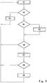
Fig. 3 shows schematically, a flow of the second embodiment according to the invention. - By means of
Fig. 1 , an embodiment of a method according to the present invention is described, i.e. automatic toll payment. Thus, said automatic toll collection is implemented on amotorway 1, which in the given case includes two carriageways 2, 3, each with twotraffic lanes 4, 5; 6, 7 and one emergency lane 8, 9. According to the present invention, it is provided for that at least one virtual toll station (hereinafter VTS) 10 is located between each entry and each exit in/from GAO, i.e. on/from motorway. - For the identification of the motorway section, two
polygons 11, 12 are used, defined by at least 4 vertices A, B, C, D and B, F, G, H, saidpolygons 11, 12 being positioned typically at the beginning and the end ofVTS 10. Saidpolygons 11, 12 cover the entire width of said motorway and run along the motorway track for a sufficient length. Said sufficient length means that at an assumed rate of capture of positions of the mobile unit 13, i.e. vehicle, (for example one capture per second) and vehicles travelling at highest speed (for example 300 km/h), at least one said position of the mobile unit 13 fits into said polygon A, B, C, D; E, F, G, H, said position of the mobile unit 13 defines with sufficient reliability belonging to GAO. Thus,Fig. 1 shows the mobile unit 13 in a given moment as a square drawn by a full line, while other possible positions are illustrated as squares drawn by a dashed line. Use of twopolygons 11, 12 ensures definition of the travel direction also in case the traffic is rerouted to the opposite direction track 2 or 3, for example, due to works on a section of themotorway 1. In the case of a motorway architecture, where carriageways of one section never run along each other (for example carriageways run around a hill on different sides i.e. dual carriageway), polygons are duplicated for each individual carriageway. Typically, carriageways 2, 3 run in parallel; thus, it is possible to join the start and theend polygons 11, 12 into a single polygon 14 with six vertices A, BE, F, G, CH, D, where the two middle vertices BE, CH represent a boundary between the first polygon 11 and thesecond polygon 12. Said polygon 14 is located at an area, which, from the viewpoint of surrounding roads and objects, is least subjected to errors due to inaccuracy of defining position and is, in case of a road toll collection on a dual lane motorway, of typical dimensions 50 metres (width) and 300 metres (length). For greater reliability of operation, the length of said polygon 14 may be extended up to the maximum possible dimension, i.e. the length of the entire object. - It is also possible, according to the present invention, to use polygons with a greater number of vertices, which typically describe a GAO of arbitrary forms, for example, an entire country, city centres, local roads with a plurality of entries and exits, parking facilities and similar. According to the first embodiment of the method for determining use of GAO according to the present invention, two
polygons 11, 12 are provided, which are merged into said polygon 14, thus considerably reducing the quantity of map data (only approximately 75% of points is required in comparison with separate polygons 11, 12). The mobile unit, a vehicle for example, is equipped with all devices for the exchange and the processing of data, and due to limited small quantity of map data the mobile unit includes also suitable data collections about VTS. Here, a list S1 represents a temporary list, where the identified polygon 14 is recorded. At the beginning of determination of GAO, the list S1 is empty. A list S2 is intended for recording of visited areas of said polygon 14,i.e. areas 11, 12. At the start of the procedure the list S2 is empty.
At first step R1 of the method according to the invention, a point T1, which represents the current position of the mobile unit 13, is defined by means of a GPS device, for example. The second step R2 verifies that said point T1 is located either inside or on the boundary of said polygon 14 recorded in said data collection at VTS. If said point does not belong to said polygon 14, i.e. is located outside of said polygon 14, said lists S1 and S2 are deleted at step R3, and the position of the mobile unit 13 is obtained again.
If said point belongs to said polygon 14, the method according to the invention advances to a subsequent step R4, where it is verified if the identified polygon 14 is included on the list S1 of polygons already identified in previous steps. If polygon 14 is not on the list S1, it means that an identification of a new polygon starts; thus, the contents of S1 and S2 are deleted, and at a step R5 the new value of said polygon 14 is recorded to S1. Said method further continues with a step R6. If said polygon 14 already exists on the list S1, then these are other or further location readings within the same polygon 14, and the method continues with the step R6, where it is verified if thearea 11, 12 of said polygon 14 is already on the list S2 of visited areas. If the area 11 has been previously recorded on the list S2, said point T1 belongs to the area already visited in previous steps; thus, the flow of the method is rerouted in order to obtain a new location according to the step R1, where also said point T1 in thesecond area 12 of the same polygon 14 is expected. If the area has not been included on the list S2, it is added in a following step R7. - If it is determined at a step R8 that all required
areas 11, 12 of said polygon 14 have been identified and consequently the direction of travel has been defined, at step R9 the tolling of GAO is activated, such as toll charging or forwarding to toll charging centre. The method is subsequently returned to the initial step R1. - The second embodiment of the method according to the invention includes an additional mechanism at steps R10, R11, which prevents the omitting of partially identified GAO, occurring due to inaccuracy of the location unit (for example, GPS). For this purpose, a
safety frame 15, which is marked as an area of possible inaccuracy of said location unit, is provided for around said polygon 14. - In said second embodiment, the point T1, which represents the current position of the mobile unit 13, is determined at first at the step R1. Thereafter, at the step R2, it is verified if the point T1 is located within said polygon 14 or on the boundary of said polygon 14, stored in said data collection. If said point belongs to said polygon 14, the flow of the method continues with the step R4 and further steps as described above for the first embodiment of the method according to the invention.
- If said point T1 misses said polygon 14, at least two causes are possible: the mobile unit 13 is actually located outside said polygon 14 (for example, it is just about to enter or just following exit from polygon) or an error occurred due to inaccuracy of the location set, which displaced the point T1 outside of said polygon 14. Thus, the step R10 first verifies if the point T1 is located within the
safety frame 15. If the point T1 is near enough of said actual polygon 14, i.e. it is located within thesafety frame 15 and outside of actual VTS, the lists S1 and S2 are not deleted since the determination of said polygon 14 may still be in process. Thus, in this case, the method returns to initial position at the step R1 in order to obtain a new point T1. - In case it is determined at the step R10 that the point T1 has fallen outside the area of the
safety frame 15 and also outside said polygon 14, it is considered that the point T1 is actually a point, which does not belong to any of said polygons 14 orareas 11, 12. In this case, the lists S1 and S2 are deleted at the step R11 and the method for determination starts again with the step R1.
Claims (5)
- Method for determining the use of a geodesically allocable object by a mobile unit (13), the geodesically allocable object comprising at least one identification area (10, 14) and at least one area (11,12), the at least one area being positioned at the at least one identification area and being in the form of a polygon connecting the vertices of the at least one area, the mobile unit (13) being adapted to exchange and process data and to store a data collection about the at least one identification area and recording the boundaries of the at least one identification area, the mobile unit (13) further being adapted to store a temporary list S1 for recording an identified identification area (14) and a list S2 for recording a visited area (11, 12) of the identified identification area, the method comprising the consecutive steps ofa) obtaining the coordinates of the mobile unit (13) at a point T1 (R1),b) verifying whether point T1 is located either inside or on the boundary of the identification area (14), using the boundaries of the identification area (14) recorded in the data collection stored in the mobile unit (R2),c) in case point T1 is outside the identification area (14), erasing the content of lists S1 and S2 and returning to step a) (R3),d) in case point T1 is inside or on the boundary of the identification area (14), verifying whether the identification area (14) is already entered in list S1 (R4),e) in case the identification area (14) is in list S1, jumping to step g),f) in case the identification area (14) is not in list S1, first erasing the content of lists S1 and S2 and then entering the identification area (14) as an identified identification area in list S1 (R5),g) verifying whether the current area (11,12) of the mobile unit (13) is already entered in list S2 (R6),h) in case the area (11,12) is in list S2, returning to step a),i) in case the area (11,12) is not in list S2, entering the area as a visited area in list S2 (R7),j) determining whether all areas (11,12) of the identification area (14) have been visited (R8),k) in case that not all areas (11,12) of the identification area (14) have been visited, returning to step a),l) in case all areas (11,12) of the identification area (14) have been visited, activating tolling for the identification area and returning to step a) (R9).
- Device for determining the use of geodesically allocable objects, said device comprising means for carrying out the method of claim 1, characterised in that for each geodesically allocable object (1) it is possible to define one or more identification areas (10) in the form of said polygon (11, 12; 14), wherein the number of vertices of said polygon (11, 12; 14) depends on the form and attributes of the geodesically allocable object (1).
- The device according to claim 2, characterised in that the number of vertices of said polygon (11, 12; 14) is at least three.
- The device according to claim 2 or 3, characterised in that between each entry into the geodesically allocable object and each exit from the geodesically allocable object there is arranged at least one identification area (10).
- The device according to any claim 2 to 4, characterised in that the number of vertices of said polygon (11, 12; 14) is such that it is possible to describe with said vertices an arbitrary geodesically allocable object, for example an entire country, city centre, local road, parking area and similar.
Applications Claiming Priority (1)
| Application Number | Priority Date | Filing Date | Title |
|---|---|---|---|
| SI200900154A SI23084A (en) | 2009-06-01 | 2009-06-01 | Procedure for assessing the use of a geodetically determinable object |
Publications (3)
| Publication Number | Publication Date |
|---|---|
| EP2259227A2 EP2259227A2 (en) | 2010-12-08 |
| EP2259227A3 EP2259227A3 (en) | 2015-03-04 |
| EP2259227B1 true EP2259227B1 (en) | 2018-03-14 |
Family
ID=42342590
Family Applications (1)
| Application Number | Title | Priority Date | Filing Date |
|---|---|---|---|
| EP09468011.3A Not-in-force EP2259227B1 (en) | 2009-06-01 | 2009-12-04 | A method of determining use of geodesically allocable objects |
Country Status (2)
| Country | Link |
|---|---|
| EP (1) | EP2259227B1 (en) |
| SI (1) | SI23084A (en) |
Family Cites Families (8)
| Publication number | Priority date | Publication date | Assignee | Title |
|---|---|---|---|---|
| JPH07117420B2 (en) * | 1988-06-27 | 1995-12-18 | パイオニア株式会社 | Road data generation method in vehicle-mounted navigation device |
| DE4402614A1 (en) * | 1994-01-28 | 1995-08-03 | Deutsche Telekom Mobil | Procedure for determining fees for the use of traffic routes by vehicles |
| AT411500B (en) * | 2001-06-12 | 2004-01-26 | Siemens Ag Oesterreich | DUAL TOLL SYSTEM |
| GB0211131D0 (en) * | 2002-05-15 | 2002-06-26 | Pa Consulting Group | A route evaluation system |
| AT414281B (en) * | 2002-09-12 | 2006-11-15 | Siemens Ag Oesterreich | PROCEDURE FOR DETERMINING THE ACCESS OF AT LEAST ONE MAJOR ROAD SECTION |
| TW591554B (en) * | 2002-10-28 | 2004-06-11 | Sin Etke Technology Co Ltd | Vehicle management system |
| US6782319B1 (en) * | 2002-11-26 | 2004-08-24 | Navteq North America, Llc | Method for organizing map data |
| ATE516564T1 (en) * | 2006-10-06 | 2011-07-15 | Deutsche Telekom Ag | ROAD USE RECORDING |
-
2009
- 2009-06-01 SI SI200900154A patent/SI23084A/en not_active IP Right Cessation
- 2009-12-04 EP EP09468011.3A patent/EP2259227B1/en not_active Not-in-force
Non-Patent Citations (1)
| Title |
|---|
| None * |
Also Published As
| Publication number | Publication date |
|---|---|
| EP2259227A2 (en) | 2010-12-08 |
| EP2259227A3 (en) | 2015-03-04 |
| SI23084A (en) | 2010-12-31 |
Similar Documents
| Publication | Publication Date | Title |
|---|---|---|
| CN103542858B (en) | Vehicle reaches target capability appraisal procedure, data library generating method, navigation system | |
| CN105654562B (en) | A kind of system and method for highway non-parking charge | |
| US5864831A (en) | Device for determining road tolls | |
| JP5919186B2 (en) | Map creation support system | |
| CN105210119B (en) | The location data points provided by computing device determine the number of pass cost | |
| CN101470966A (en) | Vehicle guidance device and computer program | |
| CN104008576B (en) | Vehicle on highway based on the Big Dipper freely flows electronic toll method, system and device | |
| JP2002503341A (en) | Method and apparatus for generation-merge-update of data available to a target guidance system in a mobile unit | |
| US12327232B2 (en) | High accuracy geo-location system and method for mobile payment | |
| CN102243811B (en) | Vehicular navigation system and recommendation paths search method | |
| CN101636772A (en) | Mobile body position information transmission device for navigation system, and mobile body position information transmission method and program for navigation system | |
| CN101470004A (en) | Navigation device and computer program | |
| CN102346042B (en) | Real time road condition based route planning method and service equipment thereof | |
| CN101470005A (en) | Navigation device and computer program | |
| CN107808420B (en) | Method and system for rapid passing and charging of road passing station | |
| CN104021593A (en) | Vehicle ETC (electronic toll collection) method, system and device based on satellite positioning system | |
| CN107516349A (en) | A vehicle fee payment method, billing system and vehicle-mounted terminal | |
| CN103456045A (en) | Method and system for carrying out charging according to GPS location | |
| CN101241609A (en) | Vehicle transit cost calculation system and its method | |
| JP2022141267A (en) | Toll Collection System and Toll Collection Method | |
| JP2015082200A (en) | Tollgate lane guide device and tollgate lane guide method | |
| CN107016742A (en) | A kind of automobile-used highroad toll collection system and highway toll method | |
| WO2003098556A1 (en) | A system for evaluating a vehicles usage within zones | |
| EP2259227A2 (en) | A method of determining use of geodesically allocable objects | |
| JP4297458B2 (en) | Navigation system and method, and recording medium recording navigation software |
Legal Events
| Date | Code | Title | Description |
|---|---|---|---|
| PUAI | Public reference made under article 153(3) epc to a published international application that has entered the european phase |
Free format text: ORIGINAL CODE: 0009012 |
|
| 17P | Request for examination filed |
Effective date: 20091204 |
|
| AK | Designated contracting states |
Kind code of ref document: A2 Designated state(s): AT BE BG CH CY CZ DE DK EE ES FI FR GB GR HR HU IE IS IT LI LT LU LV MC MK MT NL NO PL PT RO SE SI SK SM TR |
|
| AX | Request for extension of the european patent |
Extension state: AL BA RS |
|
| PUAL | Search report despatched |
Free format text: ORIGINAL CODE: 0009013 |
|
| AK | Designated contracting states |
Kind code of ref document: A3 Designated state(s): AT BE BG CH CY CZ DE DK EE ES FI FR GB GR HR HU IE IS IT LI LT LU LV MC MK MT NL NO PL PT RO SE SI SK SM TR |
|
| AX | Request for extension of the european patent |
Extension state: AL BA RS |
|
| RIC1 | Information provided on ipc code assigned before grant |
Ipc: G07B 15/00 20110101AFI20150123BHEP |
|
| RBV | Designated contracting states (corrected) |
Designated state(s): AT BE BG CH CY CZ DE DK EE ES FI FR GB GR HR HU IE IS IT LI LT LU LV MC MK MT NL NO PL PT RO SE SI SK SM TR |
|
| 17Q | First examination report despatched |
Effective date: 20160429 |
|
| GRAP | Despatch of communication of intention to grant a patent |
Free format text: ORIGINAL CODE: EPIDOSNIGR1 |
|
| INTG | Intention to grant announced |
Effective date: 20171211 |
|
| GRAS | Grant fee paid |
Free format text: ORIGINAL CODE: EPIDOSNIGR3 |
|
| GRAA | (expected) grant |
Free format text: ORIGINAL CODE: 0009210 |
|
| AK | Designated contracting states |
Kind code of ref document: B1 Designated state(s): AT BE BG CH CY CZ DE DK EE ES FI FR GB GR HR HU IE IS IT LI LT LU LV MC MK MT NL NO PL PT RO SE SI SK SM TR |
|
| REG | Reference to a national code |
Ref country code: GB Ref legal event code: FG4D |
|
| REG | Reference to a national code |
Ref country code: CH Ref legal event code: EP Ref country code: AT Ref legal event code: REF Ref document number: 979562 Country of ref document: AT Kind code of ref document: T Effective date: 20180315 |
|
| REG | Reference to a national code |
Ref country code: IE Ref legal event code: FG4D |
|
| REG | Reference to a national code |
Ref country code: DE Ref legal event code: R096 Ref document number: 602009051214 Country of ref document: DE |
|
| REG | Reference to a national code |
Ref country code: NL Ref legal event code: MP Effective date: 20180314 |
|
| REG | Reference to a national code |
Ref country code: LT Ref legal event code: MG4D |
|
| PG25 | Lapsed in a contracting state [announced via postgrant information from national office to epo] |
Ref country code: HR Free format text: LAPSE BECAUSE OF FAILURE TO SUBMIT A TRANSLATION OF THE DESCRIPTION OR TO PAY THE FEE WITHIN THE PRESCRIBED TIME-LIMIT Effective date: 20180314 Ref country code: CY Free format text: LAPSE BECAUSE OF FAILURE TO SUBMIT A TRANSLATION OF THE DESCRIPTION OR TO PAY THE FEE WITHIN THE PRESCRIBED TIME-LIMIT Effective date: 20180314 Ref country code: LT Free format text: LAPSE BECAUSE OF FAILURE TO SUBMIT A TRANSLATION OF THE DESCRIPTION OR TO PAY THE FEE WITHIN THE PRESCRIBED TIME-LIMIT Effective date: 20180314 Ref country code: NO Free format text: LAPSE BECAUSE OF FAILURE TO SUBMIT A TRANSLATION OF THE DESCRIPTION OR TO PAY THE FEE WITHIN THE PRESCRIBED TIME-LIMIT Effective date: 20180614 Ref country code: FI Free format text: LAPSE BECAUSE OF FAILURE TO SUBMIT A TRANSLATION OF THE DESCRIPTION OR TO PAY THE FEE WITHIN THE PRESCRIBED TIME-LIMIT Effective date: 20180314 Ref country code: ES Free format text: LAPSE BECAUSE OF FAILURE TO SUBMIT A TRANSLATION OF THE DESCRIPTION OR TO PAY THE FEE WITHIN THE PRESCRIBED TIME-LIMIT Effective date: 20180314 |
|
| REG | Reference to a national code |
Ref country code: AT Ref legal event code: MK05 Ref document number: 979562 Country of ref document: AT Kind code of ref document: T Effective date: 20180314 |
|
| PG25 | Lapsed in a contracting state [announced via postgrant information from national office to epo] |
Ref country code: GR Free format text: LAPSE BECAUSE OF FAILURE TO SUBMIT A TRANSLATION OF THE DESCRIPTION OR TO PAY THE FEE WITHIN THE PRESCRIBED TIME-LIMIT Effective date: 20180615 Ref country code: LV Free format text: LAPSE BECAUSE OF FAILURE TO SUBMIT A TRANSLATION OF THE DESCRIPTION OR TO PAY THE FEE WITHIN THE PRESCRIBED TIME-LIMIT Effective date: 20180314 Ref country code: SE Free format text: LAPSE BECAUSE OF FAILURE TO SUBMIT A TRANSLATION OF THE DESCRIPTION OR TO PAY THE FEE WITHIN THE PRESCRIBED TIME-LIMIT Effective date: 20180314 Ref country code: BG Free format text: LAPSE BECAUSE OF FAILURE TO SUBMIT A TRANSLATION OF THE DESCRIPTION OR TO PAY THE FEE WITHIN THE PRESCRIBED TIME-LIMIT Effective date: 20180614 |
|
| PG25 | Lapsed in a contracting state [announced via postgrant information from national office to epo] |
Ref country code: EE Free format text: LAPSE BECAUSE OF FAILURE TO SUBMIT A TRANSLATION OF THE DESCRIPTION OR TO PAY THE FEE WITHIN THE PRESCRIBED TIME-LIMIT Effective date: 20180314 Ref country code: IT Free format text: LAPSE BECAUSE OF FAILURE TO SUBMIT A TRANSLATION OF THE DESCRIPTION OR TO PAY THE FEE WITHIN THE PRESCRIBED TIME-LIMIT Effective date: 20180314 Ref country code: RO Free format text: LAPSE BECAUSE OF FAILURE TO SUBMIT A TRANSLATION OF THE DESCRIPTION OR TO PAY THE FEE WITHIN THE PRESCRIBED TIME-LIMIT Effective date: 20180314 Ref country code: NL Free format text: LAPSE BECAUSE OF FAILURE TO SUBMIT A TRANSLATION OF THE DESCRIPTION OR TO PAY THE FEE WITHIN THE PRESCRIBED TIME-LIMIT Effective date: 20180314 Ref country code: PL Free format text: LAPSE BECAUSE OF FAILURE TO SUBMIT A TRANSLATION OF THE DESCRIPTION OR TO PAY THE FEE WITHIN THE PRESCRIBED TIME-LIMIT Effective date: 20180314 |
|
| PG25 | Lapsed in a contracting state [announced via postgrant information from national office to epo] |
Ref country code: SK Free format text: LAPSE BECAUSE OF FAILURE TO SUBMIT A TRANSLATION OF THE DESCRIPTION OR TO PAY THE FEE WITHIN THE PRESCRIBED TIME-LIMIT Effective date: 20180314 Ref country code: CZ Free format text: LAPSE BECAUSE OF FAILURE TO SUBMIT A TRANSLATION OF THE DESCRIPTION OR TO PAY THE FEE WITHIN THE PRESCRIBED TIME-LIMIT Effective date: 20180314 Ref country code: SM Free format text: LAPSE BECAUSE OF FAILURE TO SUBMIT A TRANSLATION OF THE DESCRIPTION OR TO PAY THE FEE WITHIN THE PRESCRIBED TIME-LIMIT Effective date: 20180314 Ref country code: AT Free format text: LAPSE BECAUSE OF FAILURE TO SUBMIT A TRANSLATION OF THE DESCRIPTION OR TO PAY THE FEE WITHIN THE PRESCRIBED TIME-LIMIT Effective date: 20180314 |
|
| REG | Reference to a national code |
Ref country code: DE Ref legal event code: R097 Ref document number: 602009051214 Country of ref document: DE |
|
| PG25 | Lapsed in a contracting state [announced via postgrant information from national office to epo] |
Ref country code: PT Free format text: LAPSE BECAUSE OF FAILURE TO SUBMIT A TRANSLATION OF THE DESCRIPTION OR TO PAY THE FEE WITHIN THE PRESCRIBED TIME-LIMIT Effective date: 20180716 |
|
| PLBE | No opposition filed within time limit |
Free format text: ORIGINAL CODE: 0009261 |
|
| STAA | Information on the status of an ep patent application or granted ep patent |
Free format text: STATUS: NO OPPOSITION FILED WITHIN TIME LIMIT |
|
| PG25 | Lapsed in a contracting state [announced via postgrant information from national office to epo] |
Ref country code: DK Free format text: LAPSE BECAUSE OF FAILURE TO SUBMIT A TRANSLATION OF THE DESCRIPTION OR TO PAY THE FEE WITHIN THE PRESCRIBED TIME-LIMIT Effective date: 20180314 |
|
| 26N | No opposition filed |
Effective date: 20181217 |
|
| PG25 | Lapsed in a contracting state [announced via postgrant information from national office to epo] |
Ref country code: SI Free format text: LAPSE BECAUSE OF FAILURE TO SUBMIT A TRANSLATION OF THE DESCRIPTION OR TO PAY THE FEE WITHIN THE PRESCRIBED TIME-LIMIT Effective date: 20180314 |
|
| REG | Reference to a national code |
Ref country code: DE Ref legal event code: R119 Ref document number: 602009051214 Country of ref document: DE |
|
| REG | Reference to a national code |
Ref country code: CH Ref legal event code: PL |
|
| GBPC | Gb: european patent ceased through non-payment of renewal fee |
Effective date: 20181204 |
|
| PG25 | Lapsed in a contracting state [announced via postgrant information from national office to epo] |
Ref country code: MC Free format text: LAPSE BECAUSE OF FAILURE TO SUBMIT A TRANSLATION OF THE DESCRIPTION OR TO PAY THE FEE WITHIN THE PRESCRIBED TIME-LIMIT Effective date: 20180314 Ref country code: LU Free format text: LAPSE BECAUSE OF NON-PAYMENT OF DUE FEES Effective date: 20181204 |
|
| REG | Reference to a national code |
Ref country code: IE Ref legal event code: MM4A |
|
| REG | Reference to a national code |
Ref country code: BE Ref legal event code: MM Effective date: 20181231 |
|
| PG25 | Lapsed in a contracting state [announced via postgrant information from national office to epo] |
Ref country code: IE Free format text: LAPSE BECAUSE OF NON-PAYMENT OF DUE FEES Effective date: 20181204 Ref country code: DE Free format text: LAPSE BECAUSE OF NON-PAYMENT OF DUE FEES Effective date: 20190702 |
|
| PG25 | Lapsed in a contracting state [announced via postgrant information from national office to epo] |
Ref country code: BE Free format text: LAPSE BECAUSE OF NON-PAYMENT OF DUE FEES Effective date: 20181231 |
|
| PG25 | Lapsed in a contracting state [announced via postgrant information from national office to epo] |
Ref country code: LI Free format text: LAPSE BECAUSE OF NON-PAYMENT OF DUE FEES Effective date: 20181231 Ref country code: CH Free format text: LAPSE BECAUSE OF NON-PAYMENT OF DUE FEES Effective date: 20181231 Ref country code: GB Free format text: LAPSE BECAUSE OF NON-PAYMENT OF DUE FEES Effective date: 20181204 |
|
| PG25 | Lapsed in a contracting state [announced via postgrant information from national office to epo] |
Ref country code: MT Free format text: LAPSE BECAUSE OF NON-PAYMENT OF DUE FEES Effective date: 20181204 |
|
| PGFP | Annual fee paid to national office [announced via postgrant information from national office to epo] |
Ref country code: FR Payment date: 20191218 Year of fee payment: 11 |
|
| PG25 | Lapsed in a contracting state [announced via postgrant information from national office to epo] |
Ref country code: TR Free format text: LAPSE BECAUSE OF FAILURE TO SUBMIT A TRANSLATION OF THE DESCRIPTION OR TO PAY THE FEE WITHIN THE PRESCRIBED TIME-LIMIT Effective date: 20180314 |
|
| PG25 | Lapsed in a contracting state [announced via postgrant information from national office to epo] |
Ref country code: MK Free format text: LAPSE BECAUSE OF NON-PAYMENT OF DUE FEES Effective date: 20180314 Ref country code: HU Free format text: LAPSE BECAUSE OF FAILURE TO SUBMIT A TRANSLATION OF THE DESCRIPTION OR TO PAY THE FEE WITHIN THE PRESCRIBED TIME-LIMIT; INVALID AB INITIO Effective date: 20091204 |
|
| PG25 | Lapsed in a contracting state [announced via postgrant information from national office to epo] |
Ref country code: IS Free format text: LAPSE BECAUSE OF FAILURE TO SUBMIT A TRANSLATION OF THE DESCRIPTION OR TO PAY THE FEE WITHIN THE PRESCRIBED TIME-LIMIT Effective date: 20180714 |
|
| PG25 | Lapsed in a contracting state [announced via postgrant information from national office to epo] |
Ref country code: FR Free format text: LAPSE BECAUSE OF NON-PAYMENT OF DUE FEES Effective date: 20201231 |