EP2247964B1 - Verfahren zur bestimmung von geologischen informationen in bezug auf ein interessierendes unterirdisches volumen - Google Patents
Verfahren zur bestimmung von geologischen informationen in bezug auf ein interessierendes unterirdisches volumen Download PDFInfo
- Publication number
- EP2247964B1 EP2247964B1 EP09709601.0A EP09709601A EP2247964B1 EP 2247964 B1 EP2247964 B1 EP 2247964B1 EP 09709601 A EP09709601 A EP 09709601A EP 2247964 B1 EP2247964 B1 EP 2247964B1
- Authority
- EP
- European Patent Office
- Prior art keywords
- volume
- seismic
- time
- horizon
- subsurface
- Prior art date
- Legal status (The legal status is an assumption and is not a legal conclusion. Google has not performed a legal analysis and makes no representation as to the accuracy of the status listed.)
- Active
Links
Images


Classifications
-
- G—PHYSICS
- G01—MEASURING; TESTING
- G01V—GEOPHYSICS; GRAVITATIONAL MEASUREMENTS; DETECTING MASSES OR OBJECTS; TAGS
- G01V1/00—Seismology; Seismic or acoustic prospecting or detecting
- G01V1/28—Processing seismic data, e.g. for interpretation or for event detection
- G01V1/30—Analysis
- G01V1/301—Analysis for determining seismic cross-sections or geostructures
Definitions
- the invention relates to systems and methods for determining geological information related to subsurface volumes of interest.
- the invention involves determining a metric related to a rate at which strata present within a subsurface volume of interest were formed, and, in some instances, deriving further geological information from the derived metric.
- the method comprises obtaining seismic information related to a subsurface volume, wherein the seismic information represents horizons present in the subsurface volume; determining a horizon volume that automatically maps the seismic information into a flattened volume, wherein one axis of the flattened volume corresponds to chronostratigraphic time, and wherein horizons represented by the seismic information are automatically accounted for in the horizon volume, and are shifted by the horizon volume into the flattened volume to be substantially planar and substantially perpendicular to the axis of the flattened volume that corresponds to chronostratigraphic time; determining a derivative of the horizon volume with respect to chronostratigraphic time; and determining geological information related to the subsurface volume based on the derivative of the horizon volume with respect to chronostratigraphic time.
- the method comprises obtaining seismic data, wherein the seismic data is generated based on the reception of seismic impulses reflected from horizons formed within a subsurface volume; determining seismic information from the seismic data, wherein the seismic information describes the three-dimensional position of the horizons contained within the subsurface volume; determining a horizon volume that maps the seismic information into a flattened volume, wherein one axis of the flattened volume corresponds to chronostratigraphic time, and wherein the horizon volume maps the seismic information into the flattened volume such that substantially all of the horizons described in the seismic information are individually shifted to be substantially planar and substantially perpendicular to the axis of the flattened volume that corresponds to chronostratigraphic time; determining a derivative of the horizon volume with respect to chronostratigraphic time; and determining geological information related to the subsurface volume based on the derivative of the horizon volume with respect to chronostrati
- Reflection seismology is a method of exploration geophysics that uses the principles of seismology to estimate the properties of a subsurface volume of interest within the Earth's subsurface from seismic waves directed to and reflected from the subsurface volume of interest.
- the method generally requires a source of seismic waves, such as explosives ( e.g ., dynamite/Tovex), a specialized air gun, a Vibroseis, and/or other sources.
- the source is used to introduce seismic waves into the subsurface volume of interest (usually at the surface), and data is acquired by an array of seismometers (usually disposed at the surface) that detect reflections of the seismic waves generated by the source as they arrive at the surface of the subsurface volume.
- the data acquired by the seismometers is then processed (e.g ., migrated, etc .) to form a seismic data cube, which represents geological formations present within the subsurface volume at an array of data points within the subsurface volume. Since the data points within the seismic data cube are typically highly spatially sampled, the seismic data cube is effectively an image of the strata present in the subsurface volume of interest. It should be appreciated that in some instances, the seismic data can include fewer than the three dimensions of the seismic data cube discussed herein ( e.g ., one or two dimensional seismic data), and/or it can include a time dimension as well as spatial dimensions.
- FIG. 1 illustrates an elevation view of a graphical representation of seismic information related to a subsurface volume of interest 12 that represents geological formations within subsurface volume of interest 12 (e.g ., a seismic data cube obtained from performing reflection seismology on subsurface volume of interest 12). While the graphical representation provided by FIG. 1 depicts the seismic information as being contiguous, typically seismic information will represent geological formations within subsurface volume of interest 12 at an array of data points within subsurface volume of interest 12. However, due to the high spatial sampling of the seismic information (e.g ., the proximity of the data points), the information can be represented as contiguous for illustrative purposes. Further, although FIG.
- the parameters of the seismic information that represents geological formations within subsurface volume of interest 12 are a two-dimensional position in a surface plane of subsurface volume of interest 12 (e.g ., an x-axis 14, and a y-axis 16 that is orthogonal to the plane of FIG. 1 ) and a metric related to the seismic depth of subsurface volume of interest 12 ( e,g ., a t -axis 18, where t represents seismic time).
- the metric related to the seismic depth of subsurface volume of interest 12 may be a seismic time or a seismic depth. Seismic time is related to the time it takes seismic waves to travel between a point in subsurface volume of interest 12 and the surface.
- subsurface volume of interest 12 includes a plurality of horizons 20.
- a horizon is a surface formed at a boundary between two layers of differing composition within the strata of subsurface volume of interest 12. Since horizons 20 represent boundary changes in the composition of the strata of subsurface volume of interest 12, it is assumed for analysis purposes that each horizon 20 represents a surface within subsurface volume of interest 12 that was deposited at a common chronostratigraphic time. This is reasonable because the impetus for a composition change in the strata being deposited in one area of subsurface volume of interest 12 would likely be an impetus for a similar change in the composition of strata being deposited in another area of subsurface volume of interest 12. Particularly where the boundaries indicating such a change in composition for both areas connect and/or are of similar depth within subsurface volume of interest 12.
- the horizon (or other surface) can be described in terms of its location (e.g ., x,y, t coordinates) and its "dip,"
- the "dip” is a measurement of the orientation of the horizon with respect to the horizontal (or some other planar surface, typically perpendicular to the "strike").
- the dip of a given one of horizons 20 can be characterized by two components, an x-dip, or the angle of the given horizon 20 with respect to x-axis 14, and a y-dip, or the angle of the given horizon 20 with respect to y-axis 16.
- horizons 20 within subsurface volume of interest 12 generally have undulations and/or discontinuities. Some of these undulations and/or discontinuities may be caused by various phenomena associated with the deposition of the strata. These phenomena include, for example, variable sedimentation rates, variable erosion rates, surface undulations at the time of deposition, variable lithologic composition, and/or other phenomena. The undulations and/or discontinuities, in some cases, may be the result of various subsurface forces that impact the shape of horizons 20.
- These phenomena may include, for example, seismic activity, volcanic activity, ground water flow, subsurface sediment flow (e.g ., salt movement), non-uniform loading, variable compaction rates, variable rates of diagenetic consolidation, tectonically driven deformation (e.g ., folding and/or faulting), and/or other phenomena.
- FIG. 2 illustrates an elevation view of a graphical representation of flattened volume 22 that corresponds to subsurface volume of interest 12.
- horizons 20 In flattened volume 22, some or all of horizons 20 present in subsurface volume of interest 12 are reshaped to correspond to some common shape. The common shape is coplanar with a surface defined by the horizon volume as an estimate of a single chronostratigraphic time of deposition.
- horizons 20 In flattened volume 22 show in FIG. 2 , horizons 20 have been reshaped to be coplanar with a surface that is planar and horizontal.
- each of horizons 20 is considered to represent a surface within subsurface volume of interest 12 that was deposited at a common chronostratigraphic time
- the vertical axis of flattened volume 22 (illustrated in FIG. 2 and referred to hereafter as chronostratigraphic time axis 24) becomes a metric related to chronostratigraphic time of deposition, rather than seismic depth.
- the parameters of flattened volume 22 are a two-dimensional position in the surface plane of flattened volume 22, and a metric related to information related to chronostratigraphic time of deposition.
- horizons 20 have been flattened to be substantially coplanar with a surface that is planar and orthogonal to chronostratigraphic time axis 24, this should not be viewed as limiting. In some instances, horizons 20 may be flattened to be substantially coplanar with a surface that is one or both of non-planar and/or non-orthogonal to chronostratigraphic time axis 24 (e.g ., flattened to a surface that corresponds to the shape of one of horizons 20 in subsurface volume of interest 12).
- an interpreter e.g ., a user, a computer, etc .
- an interpreter can view geological features within subsurface volume of interest 12 as they were laid down originally. For example, after flattening, an interpreter could view the preserved features of an entire flood plain complete with meandering channels in a single image.
- a horizon volume is a data set that maps the obtained seismic information into flattened volume 22, and vice versa.
- the horizon volume can be conceptualized as a function that provides a position within the seismic information (e.g ., (x,y, t )) that corresponds to a given location in flattened volume 22 as a function of its position within flattened volume 22 ( e.g ., (x,y, ⁇ )).
- the designation of t for a given location (x,y, ⁇ ) in flattened volume 22 enables the information from the designated t with the same two-dimensional surface position of the given location in subsurface volume of interest 12 (e.g ., the same x and y) to be mapped into flattened volume 22 at the given location within flattened volume 22.
- seismic information will represent geological formations within subsurface volume of interest 12 at an array of data points within subsurface volume of interest 12. Therefore, another manner of conceptualizing the horizon volume is as an index of the data points in the obtained seismic information that are included in flattened volume 22, where the index designates a position of the data point in the seismic information related to subsurface volume of interest 12 that should be mapped into a given location of flattened volume 22.
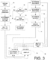
- FIG. 3 illustrates a method 26 of determining a horizon volume and processing the horizon volume to extract geological information related to a subsurface volume of interest.
- method 26 and one or more of its operations below, specific reference is made to the flattening technique described in Lomask. However, this should not be viewed as limiting. Instead, method 26 should be appreciated as being usable with a variety of different flattening techniques. Further, the particular arrangement of the operations of method 26 illustrated in FIG. 3 and described hereafter is not intended to be limiting.
- various ones of the operations could be performed in an order other than the one set forth (or concomitantly with other ones of the operations), various ones of the operations may be combined with others and/or be omitted altogether, and/or various additional operations may be added without departing from the scope of the disclosure, as should be appreciated.
- seismic information is obtained that is related to a subsurface volume of interest that represents geological formations within the subsurface volume of interest.
- the parameters of the obtained seismic information include a two-dimensional position in a surface plane, and a metric related to seismic depth.
- the seismic information obtained at operation 28 represents geological formations present within the subsurface volume of interest at an array of data points within the subsurface volume.
- the seismic information obtained at operation 28 includes a seismic data cube that represents the three-dimensional positions of geological formations present within the subsurface volume of interest.
- the seismic information obtained at operation 28 is analyzed to identify horizons present in the subsurface volume of interest.
- identifying horizons at operation 30 includes interpreting individual horizons represented within the obtained seismic information by associating each of the data points in the seismic information obtained at operation 28 that is on a given one of the identified horizons with the given horizon.
- the horizons can be interpreted automatically according to the technique described in Lomask.
- operation 30 identifies horizons present in the subsurface volume of interest with a density with respect to seismic depth/time ( e.g ., along t -axis 18 shown in FIG. 1 and described above) that is greater than a predetermined density threshold.
- the predetermined density threshold may be configurable by a user, based on one or more parameters related to the subsurface volume of interest, and/or based on parameters of the obtained seismic information).
- An example of a predetermined density threshold may be at least one horizon for each seismic period in a seismic time volume.
- An alternative horizon interpretation strategy would be to interpret every minimum or maximum or the seismic trace as a horizon.
- a horizon volume is determined that maps the seismic information obtained at operation 28 into a flattened volume such that in the flattened volume, each of the horizons identified at operation 30 are ordered according to chronostratigraphic time of deposition and are shifted to be substantially coplanar with a surface defined by the horizon volume as an estimate of a single chronostratigraphic time.
- the coordinates of the flattened volume are a two-dimensional position in the surface plane, and a metric related to chronostratigraphic time of deposition.
- the horizon volume maps the seismic information obtained at operation 28 into the flattened volume by specifying values of seismic time/depth that correspond to positions within the flattened volume.
- the metric related to chronostratigraphic time of deposition is a relative measurement of chronostratigraphic time. This will typically be the case, since the horizon volume orders the horizons identified at operation 30 according to chronostratigraphic time of deposition, but does not specify an actual value for chronostratigraphic time of deposition. However, in some instances, a user may specify a more absolute scale for the chronostratigraphic times of deposition to be applied to the relative metric provided initially by the horizon volume.
- the surface defined by the horizon volume as an estimate of a single chronostratigraphic time has a planar shape and is orthogonal to an axis that corresponds to the metric related to chronostratigraphic time, In one embodiment, the surface defined by the horizon volume as an estimate of a single chronostratigraphic time has a shape that corresponds to the shape(s) of one or more of the horizons identified at operation 28.
- the seismic information obtained at operation 28 is mapped into the flattened space according to the horizon volume. As is illustrated in FIG. 2 , and discussed above, this results in each of the horizons identified at operation 30 being shifted to be substantially coplanar with the surface defined by the horizon volume to be an estimate of a single chronostratigraphic time of deposition.
- a derivative is taken of the horizon volume determined at operation 32 with respect to the metric related to chronostratigraphic time.
- the derivative taken at operation 36 is the derivative of seismic depth specified by the horizon volume with respect to chronostratigraphic time.
- the derivative taken at operation 36 is the derivative of seismic time specified by the horizon volume with respect to the metric related to chronostratigraphic time.
- the derivative taken at operation 36 with respect to the metric related to chronostratigraphic time is taken within the horizon volume along a surface that corresponds to a single chronostratigraphic time of deposition.
- a surface would be a horizon identified at operation 30.
- other surfaces that correspond to a single chronostratigraphic time may also exist within the horizon volume.
- the predetermined set of surfaces includes at least the horizons identified at operation 30. In one embodiment, the predetermined set of surfaces excludes one or more of the horizons identified at operation 30.
- One or more of the frequency of the surfaces with respect to chronostratigraphic time, the number of surfaces, the frequency of the surfaces with respect to seismic depth/time, and/or other parameters of the set of surfaces may be configurable by users and/or may be determined automatically ( e.g ., based on the identification of horizons at operation 30, based on the seismic information obtained at operation 28, etc .).
- method 26 returns to operation 36, and the derivative of the horizon volume with respect to the metric related to chronostratigraphic time is taken along another one of the surfaces included within the predetermined set of surfaces. If the determination is made at operation 38 that the derivative of the horizon volume with respect to the metric related to chronostratigraphic time has been determined along each surface in the predetermined set of surfaces, then method 26 proceeds to an operation 40.
- the derivative taken at operation 36 for a given point in the horizon volume can be conceptualized as describing the rate at which the subsurface volume was getting "thicker" (e.g ., the subsurface volume is increasing along the t -axis 18 in FIG. 1 ) at the point in the subsurface volume that corresponds to the given point in the horizon volume.
- the subsurface volume of interest gets "thicker" as additional strata is deposited/formed.
- the derivative(s) taken at operation 36 provide a strata formation metric related to a rate at which strata present in the subsurface volume of interest was formed.
- the strata formation metric is related to, for example, a sedimentation rate, syndepositional growth rate, one or more diagenetic processes, seismic velocity, and/or other factors related to the formation of strata within the subsurface volume of interest.
- geological information related to the subsurface volume of interest is determined from the derivative(s) of the horizon volume taken with respect to the metric related to chronostratigraphic time. Operation 40 may be performed automatically ( e.g ., according to some predetermined algorithm), manually ( e.g ., by a user analyzing one or more derivatives determined at operation 36), and/or by some combination of automatic and/or manual analysis.
- the geological information includes one or more reservoir properties of the subsurface volume of interest (e.g ., a porosity, a net-to-gross, a shale volume fraction, a permeability, a lithology, a depositional facies, etc .).
- method 26 may include further operations to facilitate the determination of geological information from the derivative(s) of the horizon volume taken at operation 32.
- method 26 includes an operation 42, at which a gradient of the derivative of the horizon volume with respect to the metric related to chronostratigraphic time is determined.
- the gradient determined at operation 42 is for this derivative along a surface within the horizon volume that correspond to individual chronostratigraphic times of deposition.
- the gradient determined at operation 42 for the derivative of the horizon volume with respect to the metric related to chronostratigraphic time is determined over a three-dimensional region (e.g ., a three-dimensional region within the flattened volume, a three-dimensional region within the subsurface volume of interest, etc .).
- the gradient determined at operation 42 may be determined perpendicular to, or parallel to, a particular geological formation of interest.
- the gradient determined at operation 42 may include the gradient projected along radial lines spreading outward from a particular geological formation of interest.
- the geological formation of interest, and/or its boundaries, may be identified manually by a user and/or automatically identified.
- the determination of the gradient (or gradients) at operation 42 may facilitate the determination of geological information related to paleo-channel gradient, paleo-flow direction and rate, paleotopography, and/or other geological information.
- method 26 includes an operation 44, at which a higher order derivative of the horizon volume is taken with respect to the metric related to chronostratigraphic time of deposition (higher than the first order derivative taken at operation 36).
- operation 44 includes taking the higher order derivative along one or more surfaces in the horizon volume that correspond to individual chronostratigraphic times. The determination of the higher order derivative at operation 44 may facilitate the determination of geological information related to the timing of the onset and termination of periods of higher sedimentation.
- method 26 includes an operation 46, at which an isochron volume is determined from the derivatives taken at operation 36.
- the isochron volume is determined by associating individual positions on the surfaces for which the derivative of the horizon volume is determined at operation 36 with the corresponding values for the derivative of the horizon volume with respect to the metric related to chronostratigraphic time that are determined at operation 36.
- the isochron volume determined at operation 46 describes the derivative of seismic time specified by the horizon volume with respect to the metric related to chronostratigraphic time as a function of location within the flattened volume.
- method 26 comprises an operation 48, at which an isochore volume is determined from the derivatives taken at operation 36.
- the isochore volume is determined by associating individual positions on the surfaces for which the derivative of the horizon volume is determined at operation 36 with the corresponding values for the derivative of the horizon volume with respect to the metric related to chronostratigraphic time that are determined at operation 36.
- the isochore volume determined at operation 46 describes the derivative of seismic depth specified by the horizon volume with respect to the metric related to chronostratigraphic time as a function of location within the flattened volume.
- the isochore volume is determined based on the isochron volume determined at operation 46.
- the isochore volume may be determined by multiplying the values of the derivative of seismic time specified by the horizon volume with respect to the metric related to chronostratigraphic time included in the isochron volume, determined at operation 46, by one half of the local seismic interval velocity of the subsurface volume (or, by any scalar multiple of the local seismic interval of velocity where the metric related to chronostratigraphic time is relative, unsealed, chronostratigraphic time).
- method 26 includes an operation 50, at which an isopach volume is determined from the flattened volume derived at operation 34 and the isochore volume derived at operation 48.
- the isochore values included within the isochore volume derived at operation 48 are multiplied by the cosine of local dip.
- the local dip of a point on a given horizon within the flattened volume (which was implemented to determine the isochore volume) describes the orientation of the given horizon with respect to the horizontal in the unflattened subsurface volume of interest. Techniques for determining local dip within subsurface volumes are well-developed.
- the local dip of points within the flattened volume are computed from the seismic information obtained at operation 28, and are then mapped into the flattened volume so that the isochore values determined at operation 48 can be multiplied by the cosine of local dip to determine the isochron volume.
- method 26 includes an operation 52, at which one or more of the isochron volumes derived at operation 46, the isochore volume derived at operation 48, and/or the isopach volume derived at operation 50 are mapped, according to the horizon volume, back onto the parameters of the seismic information obtained at operation 28 ( e.g ., back into the unflattened subsurface volume of interest).
- operation 52 provides one or more volumes that include the isochron, isochore, or isopach values derived at operation 46, 48, or 50, respectively, and represents the three dimensional shape and position of the horizons identified at operation 30.
- method 26 includes an operation 54 at which information is displayed to users ( e.g ., via an electronic display).
- the information displayed at operation 54 may include information derived at one or more of operations 32, 34, 36, 42, 44, 46, 48, 50, and/or 52.
- the information displayed at operation 54 may enable the users to perform, and/or monitor or control the performance operation 40.
- operation 54 may include the display of geological information (other than, or in addition to, the geological information determined at one or more of operations 32, 34, 36, 42, 44, 46, 48, 50, and/or 52) determined at operation 40. In such instances, operation 54 effects the display of the results (or partial results) of operation 40.
Landscapes
- Engineering & Computer Science (AREA)
- Remote Sensing (AREA)
- Physics & Mathematics (AREA)
- Life Sciences & Earth Sciences (AREA)
- Acoustics & Sound (AREA)
- Environmental & Geological Engineering (AREA)
- Geology (AREA)
- General Life Sciences & Earth Sciences (AREA)
- General Physics & Mathematics (AREA)
- Geophysics (AREA)
- Geophysics And Detection Of Objects (AREA)
Claims (14)
- Von einem Rechner implementiertes Verfahren (26) zum Bestimmen von Information im Zusammenhang mit der Formation von Strata innerhalb eines unterirdischen Volumens, das Verfahren umfassendErhalten (28) von seismischen Informationen im Zusammenhang mit einem unterirdischen Volumen, die geologische Formationen innerhalb des unterirdischen Volumens darstellen, wobei die Parameter der erhaltenen seismischen Informationen einschließen (i) eine zweidimensionale Position in einer Oberflächenebene und (ii) eine seismische Zeit;Analysieren (30) der erhaltenen seismischen Informationen zum automatischen Identifizieren eines Satzes im unterirdischen Volumen vorliegender Horizonte, die durch die erhaltenen seismischen Informationen dargestellt sind;Bestimmen (32) eines Horizontvolumens aus den seismischen Informationen, wobei das Horizontvolumen die erhaltenen seismischen Informationen auf einem geplätteten Volumen (34) abbildet, so dass im geplätteten Volumen jeder der identifizierten Horizonte so versetzt wird, dass er im Wesentlichen komplanar ist mit einer Oberfläche, definiert durch das Horizontvolumen als Schätzung einer einzelnen chronostratigraphischen Zeit, wobei die Koordinaten des geplätteten Volumens (i) eine zweidimensionale Position in der Oberflächenebene sind, und (ii) eine Metrik im Zusammenhang mit der chronostratigraphischen Zeit;Bestimmen (36, 38), innerhalb des Horizontvolumens, der Ableitung von seismischer Zeit nach der chronostratigraphischen Zeit für eine bestimmte chronostratigraphische Zeit, um so eine Strata-Formationsmetrik in Zusammenhang mit einer Geschwindigkeit, mit der in einer Oberfläche des geplätteten Volumens anwesende Strata, die der gegebenen chronostratigraphischen Zeit entsprechen, zu der gegebenen chronostratigraphischen Zeit gebildet wurden, wobei die Ableitung seismischer Zeit nach der chronostratigraphischen Zeit für das Horizontvolumen für eine Mehrzahl chronostratigraphischer Zeiten bestimmt wird;Bestimmen (46) eines isochronen Volumens für die bestimmten Ableitungen;Bestimmen (48) eines isochoren Volumens auf Grundlage des isochronen Volumens; undBestimmen (50) eines isopachen Volumens aus dem geplätteten Volumen und dem bestimmten isochoren Volumen.
- Verfahren gemäß Anspruch 1, wobei der Abstand zwischen dem Satz Horizonte im geplätteten Volumen in Zusammenhang steht mit der chronostratigraphischen Zeit zwischen Ablagerung des Satzes Horizonte.
- Verfahren gemäß Anspruch 1, wobei das isochore Volumen bestimmt wird durch Multiplikation der Werte der Ableitung seismischer Zeit innerhalb des im isochronen Volumen enthaltenen Horizontvolumens mit einer Hälfte der lokalen seismischen Intervallgeschwindigkeit des unterirdischen Volumens.
- Verfahren gemäß Anspruch 1, wobei das isopache Volumen bestimmt wird durch Mulitplikation der im isochoren Volumen enthaltenen isochoren Werte mit dem Cosinus von lokaler Senke.
- Verfahren gemäß Anspruch 1, wobei die gegebene chronostratigraphische Zeit einem Horizont innerhalb des unterirdischen Volumens entspricht.
- Verfahren gemäß Anspruch 1, zudem umfassend Abbilden der Ableitung von seismischer Zeit nach der chronostratigraphischen Zeit für das Horizontvolumen zu der gegebenen chronostratigraphischen Zeit zurück in nicht abgebildete Koordinaten des unterirdischen Volumens.
- Verfahren gemäß Anspruch 1, zudem umfassend Umsetzen der Ableitung von seismischer Zeit nach chronostratigraphischer Zeit für das Horizontvolumen zu der gegebenen chronostratigraphischen Zeit zum Rückschließen von geologischer Information im Zusammenhang mit dem unterirdischen Volumen.
- Verfahren gemäß Anspruch 1, zudem umfassend Bestimmen der Neigung der Ableitung von seismischer Zeit nach chronostratigraphischer Zeit entlang der Oberfläche im geplätteten Volumen, das der gegebenen chronostratigraphischen Zeit entspricht.
- Verfahren gemäß Anspruch 1, zudem umfassend Erzeugen einer Darstellung, welche die Strata-Formationsmetrik einem Zuschauer graphisch nahebringt.
- Verfahren gemäß Anspruch 7, wobei die bestimmte geologische Information eine oder mehrere Reservoireigenschaften des unterirdischen Volumens umfasst.
- Verfahren gemäß Anspruch 1, wobei seismische Information von seismischen Daten erhalten wird, wobei die seismischen Daten erzeugt werden auf Grundlage des Empfangs seismischer Impulse, die von innerhalb des unterirdischen Volumens gebildeten Horizonten reflektiert worden sind.
- Von einem Rechner implementiertes Verfahren (26) zum Bestimmen von Information im Zusammenhang mit der Formation von Strata innerhalb eines unterirdischen Volumens, das Verfahren umfassendErhalten (28) von seismischen Informationen im Zusammenhang mit einem unterirdischen Volumen, die geologische Formationen innerhalb des unterirdischen Volumens darstellen, wobei die Koordinaten der erhaltenen seismischen Informationen sind (i) eine zweidimensionale Position in einer Flächenebene und (ii) eine seismische Tiefe;Analysieren (30) der seismischen Informationen zum automatischen Identifizieren eines Satzes im unterirdischen Volumen vorliegender Horizonte, die durch die seismischen Informationen dargestellt sind;Bestimmen (32) eines Horizontvolumens aus der seismischen Information, wobei das Horizontvolumen die erhaltene seismische Information auf ein geplättetes Volumen (34) darstellt, so dass im geplätteten Volumen jeder der identifizierten Horizonte so versetzt wird, dass er im Wesentlichen komplanar ist mit einer Oberfläche, definiert durch das Horizontvolumen als Schätzung einer einzelnen chronostratigraphischen Zeit, wobei die Koordinaten des geplätteten Volumens (i) eine zweidimensionale Position in der Oberflächenebene sind, und (ii) eine Metrik im Zusammenhang mit der chronostratigraphischen Zeit;Bestimmen (36, 38), innerhalb des Horizontvolumens, der Ableitung von seismischer Tiefe nach der chronostratigraphischen Zeit für eine bestimmte chronostratigraphische Zeit, um so eine Strata-Formationsmetrik in Zusammenhang mit einer Geschwindigkeit, mit der in einer Oberfläche des geplätteten Volumens anwesende Strata, die der gegebenen chronostratigraphischen Zeit entsprechen, zu der gegebenen chronostratigraphischen Zeit gebildet wurden, wobei die Ableitung seismischer Tiefe nach der chronostratigraphischen Zeit für das Horizontvolumen für eine Mehrzahl chronostratigraphischer Zeiten bestimmt wird;Bestimmen (48) eines isochronen Volumens für die bestimmten Ableitungen; undBestimmen (50) eines isopachen Volumens aus dem geplätteten Volumen und dem bestimmten isochoren Volumen.
- Verfahren gemäß Anspruch 12, wobei das isopache Volumen bestimmt wird durch Multiplikation der im bestimmten isochoren Volumen enthaltenen isochoren Werte mit dem Cosinus von lokaler Senke.
- System zum Bestimmen von Information im Zusammenhang mit der Formation von Strata innerhalb eines unterirdischen Volumens, wobei das System ausgelegt ist zum Ausführen des Verfahrens aus irgendeinem der vorhergehenden Ansprüche.
Applications Claiming Priority (2)
| Application Number | Priority Date | Filing Date | Title |
|---|---|---|---|
| US12/029,196 US7769545B2 (en) | 2008-02-11 | 2008-02-11 | Method for determining geological information related to a subsurface volume of interest |
| PCT/US2009/033417 WO2009102636A2 (en) | 2008-02-11 | 2009-02-06 | Method for determining geological information related to a subsurface volume of interest |
Publications (2)
| Publication Number | Publication Date |
|---|---|
| EP2247964A2 EP2247964A2 (de) | 2010-11-10 |
| EP2247964B1 true EP2247964B1 (de) | 2019-03-27 |
Family
ID=40939610
Family Applications (1)
| Application Number | Title | Priority Date | Filing Date |
|---|---|---|---|
| EP09709601.0A Active EP2247964B1 (de) | 2008-02-11 | 2009-02-06 | Verfahren zur bestimmung von geologischen informationen in bezug auf ein interessierendes unterirdisches volumen |
Country Status (8)
| Country | Link |
|---|---|
| US (1) | US7769545B2 (de) |
| EP (1) | EP2247964B1 (de) |
| CN (1) | CN102066979B (de) |
| AU (1) | AU2009215000B2 (de) |
| BR (1) | BRPI0908355A2 (de) |
| CA (1) | CA2712465C (de) |
| EA (1) | EA017591B1 (de) |
| WO (1) | WO2009102636A2 (de) |
Families Citing this family (23)
| Publication number | Priority date | Publication date | Assignee | Title |
|---|---|---|---|---|
| MY164574A (en) * | 2008-05-22 | 2018-01-15 | Exxonmobil Upstream Res Co | Seismic horizon skeletonization |
| US8515678B2 (en) * | 2010-07-29 | 2013-08-20 | Schlumberger Technology Corporation | Chrono-stratigraphic and tectono-stratigraphic interpretation on seismic volumes |
| US8086408B1 (en) * | 2011-05-23 | 2011-12-27 | NCS Subsea, Inc. | Method for positioning a wire using sensor information |
| US8332174B1 (en) | 2011-05-23 | 2012-12-11 | NCS Subsea, Inc. | Computer instructions for positioning a wire using sensor information |
| US8849574B2 (en) | 2011-07-28 | 2014-09-30 | Chevron U.S.A. Inc. | System and method for perturbing an initial horizon-picking solution to follow local features of a volume |
| US8483852B2 (en) | 2011-10-12 | 2013-07-09 | Schlumberger Technology Corporation | Representing geological objects specified through time in a spatial geology modeling framework |
| CN102520448B (zh) * | 2012-01-06 | 2013-06-19 | 中国石油化工股份有限公司胜利油田分公司西部新区研究中心 | 年代地层旋回域井震标定系统 |
| US9310501B2 (en) * | 2012-11-01 | 2016-04-12 | Chevron U.S.A. Inc. | System and method of inferring stratigraphy from suboptimal quality seismic images |
| US9146200B2 (en) | 2013-05-06 | 2015-09-29 | Chevron U.S.A. Inc. | System and method for determining an orientation of reservoir geobodies from unoriented conventional cores |
| CN104597494B (zh) * | 2013-10-31 | 2017-06-13 | 中国石油天然气集团公司 | 地震地层体分析方法及装置 |
| CN103852787B (zh) * | 2014-02-24 | 2016-08-24 | 长江大学 | 一种砂岩储层成岩地震相表征方法 |
| US9810800B2 (en) | 2014-04-30 | 2017-11-07 | Chevron U.S.A. Inc. | Method of creating and interpreting animated mosaics of multiple seismic surveys |
| FR3027944A1 (fr) * | 2014-10-29 | 2016-05-06 | Services Petroliers Schlumberger | Generation d'elements structurels pour formation souterraine utilisant une fonction implicite stratigraphique |
| CN106291725B (zh) * | 2015-05-13 | 2018-11-30 | 核工业北京地质研究院 | 一种快速反演地下地质体空间位置的方法 |
| US10605940B2 (en) | 2015-06-24 | 2020-03-31 | Exxonmobil Upstream Research Company | Method for selecting horizon surfaces |
| US20160377752A1 (en) * | 2015-06-26 | 2016-12-29 | Chevron U.S.A. Inc. | Method of Digitally Identifying Structural Traps |
| US10571585B2 (en) * | 2016-08-31 | 2020-02-25 | Chevron U.S.A. Inc. | System and method for time-lapsing seismic imaging |
| CN108828666B (zh) * | 2018-08-07 | 2019-12-27 | 中国石油大学(华东) | 一种正断层附近地层埋藏史的恢复方法 |
| US11105944B2 (en) | 2019-04-30 | 2021-08-31 | Chevron U.S.A. Inc. | System and method for lateral statistical estimation of rock and fluid properties in a subsurface formation |
| US11372131B2 (en) * | 2019-11-19 | 2022-06-28 | Chevron U.S.A. Inc. | Systems and methods for associating one or more standard numerical ages to one or more attributes of geological data from disparate locations |
| EP4244756A4 (de) * | 2020-11-13 | 2024-08-07 | Chevron U.S.A., Inc. | Charakterisierung unter der oberfläche auf der basis mehrerer korrelationsszenarien |
| EP4281813B1 (de) * | 2021-01-25 | 2025-05-14 | Totalenergies Onetech | Verfahren und system zur verarbeitung seismischer bilder zur gewinnung einer referenz-rgt-oberfläche einer geologischen formation |
| EP4281812B1 (de) * | 2021-01-25 | 2025-07-23 | Totalenergies Onetech | Verfahren und system zur verarbeitung seismischer bilder zur gewinnung eines rgt-bildes unter verwendung eines dezimierten seismischen dip-bildes |
Family Cites Families (7)
| Publication number | Priority date | Publication date | Assignee | Title |
|---|---|---|---|---|
| US5251184A (en) * | 1991-07-09 | 1993-10-05 | Landmark Graphics Corporation | Method and apparatus for finding horizons in 3D seismic data |
| GB2372567B (en) * | 2001-02-22 | 2003-04-09 | Schlumberger Holdings | Estimating subsurface subsidence and compaction |
| US6850845B2 (en) * | 2001-07-20 | 2005-02-01 | Tracy Joseph Stark | System for multi-dimensional data analysis |
| US6853922B2 (en) * | 2001-07-20 | 2005-02-08 | Tracy Joseph Stark | System for information extraction from geologic time volumes |
| AU2002329615B2 (en) * | 2001-07-20 | 2006-12-07 | Tracy Joseph Stark | System for information extraction from geologic time volumes |
| EP2372398A3 (de) * | 2006-06-21 | 2012-04-11 | Terraspark Geosciences, LLC | Extraktion von Ablagerungssystemen |
| US7702463B2 (en) * | 2007-12-12 | 2010-04-20 | Landmark Graphics Corporation, A Halliburton Company | Systems and methods for enhancing a seismic data image |
-
2008
- 2008-02-11 US US12/029,196 patent/US7769545B2/en active Active
-
2009
- 2009-02-06 BR BRPI0908355-3A patent/BRPI0908355A2/pt not_active IP Right Cessation
- 2009-02-06 EA EA201070952A patent/EA017591B1/ru not_active IP Right Cessation
- 2009-02-06 CN CN200980104704.0A patent/CN102066979B/zh active Active
- 2009-02-06 AU AU2009215000A patent/AU2009215000B2/en active Active
- 2009-02-06 EP EP09709601.0A patent/EP2247964B1/de active Active
- 2009-02-06 WO PCT/US2009/033417 patent/WO2009102636A2/en not_active Ceased
- 2009-02-06 CA CA2712465A patent/CA2712465C/en active Active
Non-Patent Citations (1)
| Title |
|---|
| None * |
Also Published As
| Publication number | Publication date |
|---|---|
| US7769545B2 (en) | 2010-08-03 |
| AU2009215000A1 (en) | 2009-08-20 |
| CA2712465C (en) | 2016-11-29 |
| CA2712465A1 (en) | 2009-08-20 |
| US20090204331A1 (en) | 2009-08-13 |
| AU2009215000B2 (en) | 2015-04-02 |
| CN102066979B (zh) | 2013-11-06 |
| BRPI0908355A2 (pt) | 2015-07-28 |
| WO2009102636A3 (en) | 2010-11-25 |
| EA017591B1 (ru) | 2013-01-30 |
| EP2247964A2 (de) | 2010-11-10 |
| EA201070952A1 (ru) | 2011-02-28 |
| WO2009102636A2 (en) | 2009-08-20 |
| CN102066979A (zh) | 2011-05-18 |
Similar Documents
| Publication | Publication Date | Title |
|---|---|---|
| EP2247964B1 (de) | Verfahren zur bestimmung von geologischen informationen in bezug auf ein interessierendes unterirdisches volumen | |
| EP2250520B1 (de) | Verfahren zum indizieren eines unterirdischen volumens zum zwecke des schliessens auf geologische informationen | |
| EP1071970B1 (de) | Verarbeitung von konvertierten wellen in mehrschichtige, anisotropische geologische formationen | |
| AU710968B2 (en) | Method and apparatus for seismic signal processing and exploration | |
| US7952960B2 (en) | Seismic imaging with natural Green's functions derived from VSP data | |
| US6055482A (en) | Method of seismic signal processing | |
| CA2940406C (en) | Characterizing a physical structure using a multidimensional noise model to attenuate noise data | |
| EP3158368B1 (de) | Auf instantem isochronenattribut basierende geokörperidentifizierung zur reservoirmodellierung | |
| CA2764705A1 (en) | Method for stratigraphic analysis of seismic data | |
| EP2548052B1 (de) | System und verfahren zur 3d-salzflanken-vsp-bildgebung mit übertragenen wellen | |
| CN101663597A (zh) | 根据2-d地震数据进行3-d散射体成像 | |
| US20160377752A1 (en) | Method of Digitally Identifying Structural Traps | |
| WO2024205630A1 (en) | Systems and methods for using the delayed-time information to analyze model accuracy and update models | |
| US20240219596A1 (en) | Method and apparatus for estimating uncertainty of a velocity model of a subsurface region | |
| AU2015201019B2 (en) | Method for indexing a subsurface volume for the purpose of inferring geologic information | |
| EP2992363A2 (de) | Verfahren zur verbesserung von flat spots in der dreidimensionalen seismischen interpretation | |
| Dorn et al. | Stratal Domain Transformation-A Workflow |
Legal Events
| Date | Code | Title | Description |
|---|---|---|---|
| PUAI | Public reference made under article 153(3) epc to a published international application that has entered the european phase |
Free format text: ORIGINAL CODE: 0009012 |
|
| 17P | Request for examination filed |
Effective date: 20100913 |
|
| AK | Designated contracting states |
Kind code of ref document: A2 Designated state(s): AT BE BG CH CY CZ DE DK EE ES FI FR GB GR HR HU IE IS IT LI LT LU LV MC MK MT NL NO PL PT RO SE SI SK TR |
|
| AX | Request for extension of the european patent |
Extension state: AL BA RS |
|
| R17D | Deferred search report published (corrected) |
Effective date: 20101125 |
|
| DAX | Request for extension of the european patent (deleted) | ||
| STAA | Information on the status of an ep patent application or granted ep patent |
Free format text: STATUS: EXAMINATION IS IN PROGRESS |
|
| 17Q | First examination report despatched |
Effective date: 20180611 |
|
| GRAP | Despatch of communication of intention to grant a patent |
Free format text: ORIGINAL CODE: EPIDOSNIGR1 |
|
| STAA | Information on the status of an ep patent application or granted ep patent |
Free format text: STATUS: GRANT OF PATENT IS INTENDED |
|
| INTG | Intention to grant announced |
Effective date: 20180921 |
|
| GRAS | Grant fee paid |
Free format text: ORIGINAL CODE: EPIDOSNIGR3 |
|
| GRAA | (expected) grant |
Free format text: ORIGINAL CODE: 0009210 |
|
| STAA | Information on the status of an ep patent application or granted ep patent |
Free format text: STATUS: THE PATENT HAS BEEN GRANTED |
|
| AK | Designated contracting states |
Kind code of ref document: B1 Designated state(s): AT BE BG CH CY CZ DE DK EE ES FI FR GB GR HR HU IE IS IT LI LT LU LV MC MK MT NL NO PL PT RO SE SI SK TR |
|
| REG | Reference to a national code |
Ref country code: GB Ref legal event code: FG4D |
|
| REG | Reference to a national code |
Ref country code: CH Ref legal event code: EP |
|
| REG | Reference to a national code |
Ref country code: DE Ref legal event code: R096 Ref document number: 602009057618 Country of ref document: DE |
|
| REG | Reference to a national code |
Ref country code: AT Ref legal event code: REF Ref document number: 1113757 Country of ref document: AT Kind code of ref document: T Effective date: 20190415 |
|
| REG | Reference to a national code |
Ref country code: IE Ref legal event code: FG4D |
|
| REG | Reference to a national code |
Ref country code: NL Ref legal event code: FP |
|
| PG25 | Lapsed in a contracting state [announced via postgrant information from national office to epo] |
Ref country code: LT Free format text: LAPSE BECAUSE OF FAILURE TO SUBMIT A TRANSLATION OF THE DESCRIPTION OR TO PAY THE FEE WITHIN THE PRESCRIBED TIME-LIMIT Effective date: 20190327 Ref country code: SE Free format text: LAPSE BECAUSE OF FAILURE TO SUBMIT A TRANSLATION OF THE DESCRIPTION OR TO PAY THE FEE WITHIN THE PRESCRIBED TIME-LIMIT Effective date: 20190327 Ref country code: FI Free format text: LAPSE BECAUSE OF FAILURE TO SUBMIT A TRANSLATION OF THE DESCRIPTION OR TO PAY THE FEE WITHIN THE PRESCRIBED TIME-LIMIT Effective date: 20190327 |
|
| PG25 | Lapsed in a contracting state [announced via postgrant information from national office to epo] |
Ref country code: BG Free format text: LAPSE BECAUSE OF FAILURE TO SUBMIT A TRANSLATION OF THE DESCRIPTION OR TO PAY THE FEE WITHIN THE PRESCRIBED TIME-LIMIT Effective date: 20190627 Ref country code: LV Free format text: LAPSE BECAUSE OF FAILURE TO SUBMIT A TRANSLATION OF THE DESCRIPTION OR TO PAY THE FEE WITHIN THE PRESCRIBED TIME-LIMIT Effective date: 20190327 Ref country code: GR Free format text: LAPSE BECAUSE OF FAILURE TO SUBMIT A TRANSLATION OF THE DESCRIPTION OR TO PAY THE FEE WITHIN THE PRESCRIBED TIME-LIMIT Effective date: 20190628 Ref country code: HR Free format text: LAPSE BECAUSE OF FAILURE TO SUBMIT A TRANSLATION OF THE DESCRIPTION OR TO PAY THE FEE WITHIN THE PRESCRIBED TIME-LIMIT Effective date: 20190327 |
|
| REG | Reference to a national code |
Ref country code: AT Ref legal event code: MK05 Ref document number: 1113757 Country of ref document: AT Kind code of ref document: T Effective date: 20190327 |
|
| REG | Reference to a national code |
Ref country code: NO Ref legal event code: T2 Effective date: 20190327 |
|
| PG25 | Lapsed in a contracting state [announced via postgrant information from national office to epo] |
Ref country code: PT Free format text: LAPSE BECAUSE OF FAILURE TO SUBMIT A TRANSLATION OF THE DESCRIPTION OR TO PAY THE FEE WITHIN THE PRESCRIBED TIME-LIMIT Effective date: 20190727 Ref country code: ES Free format text: LAPSE BECAUSE OF FAILURE TO SUBMIT A TRANSLATION OF THE DESCRIPTION OR TO PAY THE FEE WITHIN THE PRESCRIBED TIME-LIMIT Effective date: 20190327 Ref country code: SK Free format text: LAPSE BECAUSE OF FAILURE TO SUBMIT A TRANSLATION OF THE DESCRIPTION OR TO PAY THE FEE WITHIN THE PRESCRIBED TIME-LIMIT Effective date: 20190327 Ref country code: EE Free format text: LAPSE BECAUSE OF FAILURE TO SUBMIT A TRANSLATION OF THE DESCRIPTION OR TO PAY THE FEE WITHIN THE PRESCRIBED TIME-LIMIT Effective date: 20190327 Ref country code: IT Free format text: LAPSE BECAUSE OF FAILURE TO SUBMIT A TRANSLATION OF THE DESCRIPTION OR TO PAY THE FEE WITHIN THE PRESCRIBED TIME-LIMIT Effective date: 20190327 Ref country code: CZ Free format text: LAPSE BECAUSE OF FAILURE TO SUBMIT A TRANSLATION OF THE DESCRIPTION OR TO PAY THE FEE WITHIN THE PRESCRIBED TIME-LIMIT Effective date: 20190327 Ref country code: RO Free format text: LAPSE BECAUSE OF FAILURE TO SUBMIT A TRANSLATION OF THE DESCRIPTION OR TO PAY THE FEE WITHIN THE PRESCRIBED TIME-LIMIT Effective date: 20190327 |
|
| PG25 | Lapsed in a contracting state [announced via postgrant information from national office to epo] |
Ref country code: PL Free format text: LAPSE BECAUSE OF FAILURE TO SUBMIT A TRANSLATION OF THE DESCRIPTION OR TO PAY THE FEE WITHIN THE PRESCRIBED TIME-LIMIT Effective date: 20190327 |
|
| PG25 | Lapsed in a contracting state [announced via postgrant information from national office to epo] |
Ref country code: IS Free format text: LAPSE BECAUSE OF FAILURE TO SUBMIT A TRANSLATION OF THE DESCRIPTION OR TO PAY THE FEE WITHIN THE PRESCRIBED TIME-LIMIT Effective date: 20190727 Ref country code: AT Free format text: LAPSE BECAUSE OF FAILURE TO SUBMIT A TRANSLATION OF THE DESCRIPTION OR TO PAY THE FEE WITHIN THE PRESCRIBED TIME-LIMIT Effective date: 20190327 |
|
| REG | Reference to a national code |
Ref country code: DE Ref legal event code: R097 Ref document number: 602009057618 Country of ref document: DE |
|
| PG25 | Lapsed in a contracting state [announced via postgrant information from national office to epo] |
Ref country code: DK Free format text: LAPSE BECAUSE OF FAILURE TO SUBMIT A TRANSLATION OF THE DESCRIPTION OR TO PAY THE FEE WITHIN THE PRESCRIBED TIME-LIMIT Effective date: 20190327 |
|
| PLBE | No opposition filed within time limit |
Free format text: ORIGINAL CODE: 0009261 |
|
| STAA | Information on the status of an ep patent application or granted ep patent |
Free format text: STATUS: NO OPPOSITION FILED WITHIN TIME LIMIT |
|
| PG25 | Lapsed in a contracting state [announced via postgrant information from national office to epo] |
Ref country code: SI Free format text: LAPSE BECAUSE OF FAILURE TO SUBMIT A TRANSLATION OF THE DESCRIPTION OR TO PAY THE FEE WITHIN THE PRESCRIBED TIME-LIMIT Effective date: 20190327 |
|
| 26N | No opposition filed |
Effective date: 20200103 |
|
| PG25 | Lapsed in a contracting state [announced via postgrant information from national office to epo] |
Ref country code: TR Free format text: LAPSE BECAUSE OF FAILURE TO SUBMIT A TRANSLATION OF THE DESCRIPTION OR TO PAY THE FEE WITHIN THE PRESCRIBED TIME-LIMIT Effective date: 20190327 |
|
| REG | Reference to a national code |
Ref country code: DE Ref legal event code: R119 Ref document number: 602009057618 Country of ref document: DE |
|
| REG | Reference to a national code |
Ref country code: CH Ref legal event code: PL |
|
| REG | Reference to a national code |
Ref country code: BE Ref legal event code: MM Effective date: 20200229 |
|
| PG25 | Lapsed in a contracting state [announced via postgrant information from national office to epo] |
Ref country code: MC Free format text: LAPSE BECAUSE OF FAILURE TO SUBMIT A TRANSLATION OF THE DESCRIPTION OR TO PAY THE FEE WITHIN THE PRESCRIBED TIME-LIMIT Effective date: 20190327 Ref country code: LU Free format text: LAPSE BECAUSE OF NON-PAYMENT OF DUE FEES Effective date: 20200206 |
|
| PG25 | Lapsed in a contracting state [announced via postgrant information from national office to epo] |
Ref country code: CH Free format text: LAPSE BECAUSE OF NON-PAYMENT OF DUE FEES Effective date: 20200229 Ref country code: LI Free format text: LAPSE BECAUSE OF NON-PAYMENT OF DUE FEES Effective date: 20200229 |
|
| PG25 | Lapsed in a contracting state [announced via postgrant information from national office to epo] |
Ref country code: DE Free format text: LAPSE BECAUSE OF NON-PAYMENT OF DUE FEES Effective date: 20200901 Ref country code: IE Free format text: LAPSE BECAUSE OF NON-PAYMENT OF DUE FEES Effective date: 20200206 |
|
| PG25 | Lapsed in a contracting state [announced via postgrant information from national office to epo] |
Ref country code: BE Free format text: LAPSE BECAUSE OF NON-PAYMENT OF DUE FEES Effective date: 20200229 |
|
| PG25 | Lapsed in a contracting state [announced via postgrant information from national office to epo] |
Ref country code: MT Free format text: LAPSE BECAUSE OF FAILURE TO SUBMIT A TRANSLATION OF THE DESCRIPTION OR TO PAY THE FEE WITHIN THE PRESCRIBED TIME-LIMIT Effective date: 20190327 Ref country code: CY Free format text: LAPSE BECAUSE OF FAILURE TO SUBMIT A TRANSLATION OF THE DESCRIPTION OR TO PAY THE FEE WITHIN THE PRESCRIBED TIME-LIMIT Effective date: 20190327 |
|
| PG25 | Lapsed in a contracting state [announced via postgrant information from national office to epo] |
Ref country code: MK Free format text: LAPSE BECAUSE OF FAILURE TO SUBMIT A TRANSLATION OF THE DESCRIPTION OR TO PAY THE FEE WITHIN THE PRESCRIBED TIME-LIMIT Effective date: 20190327 |
|
| P01 | Opt-out of the competence of the unified patent court (upc) registered |
Effective date: 20230525 |
|
| PGFP | Annual fee paid to national office [announced via postgrant information from national office to epo] |
Ref country code: FR Payment date: 20241231 Year of fee payment: 17 |
|
| PGFP | Annual fee paid to national office [announced via postgrant information from national office to epo] |
Ref country code: NL Payment date: 20250106 Year of fee payment: 17 |
|
| PGFP | Annual fee paid to national office [announced via postgrant information from national office to epo] |
Ref country code: NO Payment date: 20250212 Year of fee payment: 17 |
|
| PGFP | Annual fee paid to national office [announced via postgrant information from national office to epo] |
Ref country code: GB Payment date: 20250102 Year of fee payment: 17 |