EP2209092A1 - Procédé de visualisation unifiée d'ensembles de données hétérogènes - Google Patents
Procédé de visualisation unifiée d'ensembles de données hétérogènes Download PDFInfo
- Publication number
- EP2209092A1 EP2209092A1 EP09150799A EP09150799A EP2209092A1 EP 2209092 A1 EP2209092 A1 EP 2209092A1 EP 09150799 A EP09150799 A EP 09150799A EP 09150799 A EP09150799 A EP 09150799A EP 2209092 A1 EP2209092 A1 EP 2209092A1
- Authority
- EP
- European Patent Office
- Prior art keywords
- detail
- tile
- level
- computer
- clipmap
- Prior art date
- Legal status (The legal status is an assumption and is not a legal conclusion. Google has not performed a legal analysis and makes no representation as to the accuracy of the status listed.)
- Withdrawn
Links
Images


Classifications
-
- G—PHYSICS
- G06—COMPUTING; CALCULATING OR COUNTING
- G06T—IMAGE DATA PROCESSING OR GENERATION, IN GENERAL
- G06T17/00—Three dimensional [3D] modelling, e.g. data description of 3D objects
- G06T17/20—Finite element generation, e.g. wire-frame surface description, tesselation
-
- G—PHYSICS
- G06—COMPUTING; CALCULATING OR COUNTING
- G06T—IMAGE DATA PROCESSING OR GENERATION, IN GENERAL
- G06T15/00—3D [Three Dimensional] image rendering
- G06T15/04—Texture mapping
Definitions
- the present invention relates to a computer-readable data storage medium comprising a graphic dataset in the form of a mipmap, and to a method of extracting from said computer-readable data storage medium to a computer memory a subset of said mipmap in the form of a clipmap.
- the present invention relates also to a computer memory containing such a clipmap, as well as to a method of rendering said clipmap in a computer system.
- computer-readable data storage medium any computer-readable support containing digital data, including, but not restricted to, a solid state memory such as a random access memory, a flash memory, or a read-only memory, but also a magnetic data storage medium such as a hard disk drive or a magnetic tape, an optical data storage medium such as an optical disk, etc.
- graphic data digital data comprising visual and positional features of real and/or virtual entities in an at least three-dimensional space.
- graphic data may include, but are not necessarily restricted to, texture and/or geometric data.
- computer memory any computer-readable and -writeable data storage medium, including, but not restricted to, a solid state memory such as a random access memory or a flash memory, but also a magnetic data storage medium such as a hard disk drive or a magnetic tape, an optical data storage medium such as an optical disk, etc.
- rendering it is meant the conversion of these graphic data into a two-dimensional pixel array for displaying a view of said real or virtual entities from a determined viewpoint in said at-least three-dimensional space.
- a number of computer graphics applications such as, for example, flight simulators, geographical information systems, navigation systems, etc. need to allow the representation of subsets of large graphic datasets on a display, with frequent updates. For instance, in a flight simulator, this allows a user to visualize terrain updated in real time from a large graphic terrain dataset as the user flies over the simulated terrain.
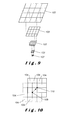
- a mipmap 1 (from the Latin "multum in parvo" - many in a small space) is a graphic dataset comprising a collection of multiple versions 2 of the same image at multiple different levels of detail, as represented in Fig. 1 . If the different levels of detail are stacked, they form a pyramid, as represented in Fig. 2 .
- a subset of graphic data to be rendered will be extracted from a lower mipmap level of detail, whereas to display a close-up, the subset will be extracted from a higher mipmap level of detail. This reduces the real-time data processing requirements, and helps prevent image aliasing.
- a mipmap when the highest level of detail is a very large image, such as, for instance, in a geographic information system, a map of the whole Earth at 1m resolution, a mipmap will comprise an exceedingly large amount of data, which will require a large memory. Since, at a given cost, increased memory size normally means lower access speed, this is disadvantageous for those applications requiring rapid or even real-time updates. For this reason, in Tanner et al., "The Clipmap: A Virtual Mipmap", Proceedings of the 25th annual conference on Computer graphics and interactive techniques, 1998 , a more efficient method called clipped mipmapping, or clipmapping, was proposed instead.
- this clipmapping method clips from each level a clip region 3 around the current viewpoint defining an area of interest equal or slightly larger than the display size, as shown in Fig. 3 .
- a "clipmap" 4 comprising the stack of all clip regions 3, schematically illustrated in Fig. 4 , can thus be cached in a smaller, but faster access computer memory than the whole mipmap 1. If the viewpoint moves, the clip regions in the clipmap are toroidally updated, that is, graphic data of areas 5,6,7 entering each clip region 3 replace in said cache those of areas 8,9,10 leaving the clip region, as illustrated in Fig. 5 .
- US Patent Application Publication 2007/0171234 A1 discloses a method of extracting towards a computer memory a subset of graphic data in the form of a clipmap from a larger graphic dataset in the form of a mipmap, wherein:
- each tile at each level of detail excepting the highest is coextensive with a discrete plurality of tiles at its next level of detail.
- coextensive it is meant that it covers the same part of the represented entity. For example, if the represented entity is geographic, a tile at the N level of detail covers the same geographic area as a discrete plurality of tiles at the N+1 level of detail.
- Tile mosaics comprising tiles of several different levels of detail can thus easily be created by neatly nesting tiles of a higher level of detail between tiles of a lower level of detail.
- the clean transition between different levels of detail within such tile mosaics facilitates the prevention of "popping" effects, and, when the graphic data comprise three-dimensional geometry data, of vertical gaps: for instance, each tile may be provided with vertical curtains along its edges, thus closing any such gaps.
- the coordinates used to represent those features need both high precision and a large range, which sets very high requirements for the graphics hardware.
- single-precision floating point coordinates as conventionally used in commodity graphics processors, may be insufficient.
- the clip region straddles the so-called "dateline", that is, covers two opposite extremes of a graphic data array of a given level of detail of a mipmap, as illustrated in Fig.
- the graphic data within each tile may thus comprise position coordinates within a coordinate system local to the tile.
- the local tile coordinates of that graphic feature can be combined with the grid position of the tile and its level of detail to obtain its global position.
- Rendering clipmaps extracted from such mipmaps is also facilitated by the use of local tile coordinates. Since in a clipmap the clip regions at the highest levels of detail cover only areas closest to the viewpoint, calculating the relative position of the viewpoint with respect to graphic features in those clip regions in local tile coordinates will require a narrower range than in global coordinates, while maintaining a high precision.
- each graphic data array may comprise texture and/or geometry data, for example in the form of a texel map and/or a vertex network.
- Each graphic data array forming the mipmap may thus be in the form of a relief and/or texture map.
- Graphic data arrays within such a mipmap may thus be sparsely populated, with only some of the tiles being occupied with those data. For instance, at the highest levels of detail, only tiles within areas of particular interest may be populated with texture and/or geometry data. This can be particularly advantageous for reducing data storage requirements and rendering time.
- tiles may comprise data other than texture and/or geometry data, such as, for instance, 3D representations of geographic features other than relief and texture, e.g. buildings, roads, vegetation, 2D or 3D raster data, e.g. weather data, or even non-visual data, e.g. textual information, a uniform resource identifier, etc.
- 3D representations of geographic features other than relief and texture e.g. buildings, roads, vegetation, 2D or 3D raster data
- non-visual data e.g. textual information, a uniform resource identifier, etc.
- a texture tile may contain a bitmap image.
- the image may be encoded on disk in any graphics exchange format such as JPEG, PNG or TIFF and may be loaded into video memory when the tile is needed for rendering.
- a geometry tile may contain an array of graphical primitives, such as points, lines, or polygons.
- the primitives may be defined by vertices with 2D or 3D coordinates.
- the vertices may optionally have additional attributes such as texture coordinates, colours or normal vectors.
- the primitives may cross the boundaries of the tile provided that there is an unambiguous way to assign a primitive to a tile on each detail level. If this constraint were not in place, a single primitive might be assigned to multiple tiles and could consequently be rendered more than once.
- a tile may also contain other types of data such as video, audio or text.
- each tile at each mipmap level of detail but the highest is coextensive with a square tile array, preferably a 2x2 tile array, at its next level of detail.
- a square tile array preferably a 2x2 tile array
- an excessive jump in detail between adjacent levels of detail is prevented.
- each tile in at least one mipmap level of the detail, may be coextensive with a square array of more than 2x2 tiles, or with a non-square array, or even with a more than two-dimensional, square or non-square tile array. For instance, for data with a high degree of complexity along the vertical axis, it may be useful for the graphic data array at at least one level of detail to be a three-dimensional array of tiles.
- each tile may comprise a tile position index indicating its position within the grid at its level of detail.
- the present invention also relates to a method of extracting, from the abovementioned computer-readable data storage medium to a computer memory, a subset of said mipmap in the form of a clipmap, wherein said method comprises the steps of:
- the resulting clipmap can thus be cached in a computer memory having a significantly smaller capacity, and thus normally a shorter access time, than said computer-readable data-storage medium.
- the abovementioned clipmap extraction method may further comprise a step of updating each clip region after said viewpoint changes by replacing, in said intermediate memory, the least recently used tiles of each clip region with those tiles entering the clip region.
- said computer-readable data storage medium may be a remote computer-readable data storage medium connected with said computer memory over a communication network.
- Said communication network may be a local area network, or a wide area network. It may be an Internet Protocol-based network, such as the Internet itself, allowing a robust communication connection to the remote computer-readable data storage network, possibly worldwide. It may be over cables or at least partially wireless.
- Such a remote computer-readable data storage medium could thus be accessed from a plurality of locations, possibly simultaneously, and thus concentrate the large amount of graphic data required for the mipmap into a single computer-readable data storage medium for a plurality of users.
- the present invention relates also to the abovementioned computer memory containing such a clipmap, which may be extracted from a tiled mipmap using the abovementioned method, or directly generated tile-by-tile.
- said computer memory may be a system memory, that is, the main memory of a computer, directly linked to the computer's core processor.
- the rendering method of the invention comprises the steps of:
- the resulting pixel array may be visually displayed through a display unit, such as, for example, a cathode ray tube, an LCD screen or projector, a plasma screen, a LED display unit, an OLED display unit, or any other suitable device for displaying a pixel array as a visible image.
- a display unit such as, for example, a cathode ray tube, an LCD screen or projector, a plasma screen, a LED display unit, an OLED display unit, or any other suitable device for displaying a pixel array as a visible image.
- the methods of the present invention are particularly useful for geographical information applications.
- a whole-Earth texture map with a 1 m resolution will require a texture size of 2 26 .
- Direct processing of such a texture size is already well beyond the possibilities of current home computers. If, besides texture, a geographical information system has to represent additional data, such as relief data, specific geographical features, etc. the hardware requirements are pushed even further. Fig.
- a whole-Earth geographical mipmap 101 comprising texture data, but also possibly 3D geometric data in the form of a vertex grid, and/or 3D models of particular geographical features such as, for example, buildings, roads, tracks, vegetation, etc., as well as, eventually, additional textual, numerical, aural and/or visual information, such as, for example descriptive texts, uniform resource indicators, statistics, graphs, music, etc.
- This mipmap 101 is formed by graphic data arrays 102 representing the entire surface of the Earth at several different levels of detail.
- the linear definition of the texture and geometric data increases by a factor of two from a graphic data array 102 at one level of detail to the graphic data array 102 at the next level of detail.
- the increase in the definition from one level of detail to the next may differ.
- Each graphic data array 102 is divided by a grid 103 into tiles 104.
- each tile 104 at a given level of detail (but the highest) of the mipmap is coextensive with a 2x2 block 105 of tiles 104 at the next level of detail of the mipmap, covering the same area of the Earth. Therefore, since the linear definition also increases by a factor two, each tile 104 at any level of detail comprises approximately the same amount of data.
- the graphic data arrays 102 at some levels of detail for example at the highest levels of detail, may be sparsely populated, for instance by leaving one or several tiles 104 empty of graphic data.
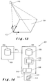
- a clip region 107 is selected from a graphic data array 102 at a lowest level of detail by first locating the grid intersection 108 closest to the viewpoint 106 or to a central line of view from the viewpoint 106 (that is, closest to the centre of the display when the clip region 107 is rendered). Having set a maximum clip region size in this particular embodiment of 4x4 tiles 104, a clip region 107 of that size, centred on the intersection 108, is then selected, and the corresponding tiles 104 clipped from the mipmap 101.
- the maximum clip region size is, at that level of detail, larger than the graphic data array 102, only the tiles 104 within the intersection of the graphic data array 102 and the theoretical clip region of maximum clip region size centred on the grid intersection 108 will be clipped to the real clip region 107.
- the same operation would then be performed, clipping clip regions 107 of 4x4 tiles centred on the same grid intersection, but, as the individual tile area decreases, covering an increasingly smaller geographical area. This may be continued until a maximum clipmap level of detail, which may be lower than the maximum mipmap level of detail.
- the maximum clipmap level of detail may be determined in function of the altitude of the viewpoint 106 with respect to the surface of the Earth.
- the maximum clipmap level of detail may be the lowest level of detail which fulfils the equation A ⁇ D*Q, wherein A is the altitude, D is a linear dimension of the geographic area covered by clip region 107, such as its diagonal, and Q a predetermined quality parameter.
- clip regions 107 can then be stored in a significantly smaller memory space than the entire mipmap 101 to form a tiled clipmap 109 as illustrated in Fig. 9 .
- the clip region 107 is only updated when the viewpoint 106 comes closer to another grid intersection 110, as illustrated in Fig. 10 .
- Full tiles 104 entering the clip region 107 then replace the least recently used tiles 104 within the clip region 107.
- this increases the granularity of the updates, it reduces their frequency and thus the updating requirements. Since, with the finer grids of the higher levels of detail, the updates will be more frequent, the granularity also decreases with increasing levels of detail, so that it is less perceptible by the user.
- Fig. 11 illustrates the process of rendering this tiled clipmap 109 for display.
- a first step 201 it is checked for each tile 104 at that level of detail whether the clip region 107 at the next higher level of detail contains a coextensive 2x2 block 105 of tiles 104. If this is the case, the level of detail is increased by one in the next step 202, and the same check 201 is carried out again for each tile 104 in said 2x2 block 105 of tiles 104.
- a tile mosaic 111 as illustrated in Fig. 12 is thus formed, with blocks 105 of smaller, higher-definition tiles 104 successively nested between larger tiles 104.
- the local tile coordinate system 112 will be appropriate to locate both the viewpoint 106 and the visual features within the tile 104 with high relative precision without requiring a high range. Using this local coordinate system, drawing in step 204 the visual features of tile 104 as seen from viewpoint 106 will thus be possible with, for example, single-precision floating point coordinates as used by commodity graphics processors.
- Fig. 14 illustrates an embodiment of a computer system 301 for carrying out these clipmapping and rendering methods.
- the tiled mipmap 101 is stored in a computer-readable data storage medium 302, which may be many terabytes in size, within a remote server 303 connected over a network 304 with one or several client computers 305.
- Said network 304 may be a local area network, or a wide area network. It may be an Internet Protocol-based network, such as the Internet itself, allowing a robust communication connection to the remote computer-readable data storage network, possibly worldwide. It may be over cables or at least partially wireless.
- Tiles 104 that can be expected to be required for the tiled clipmap 109 in the medium term may be transmitted over said network 304 to be stored into a local disk storage cache 306 of the client computer 305 to minimise the impact of network latency.
- This local disk storage cache 306 may thus be much smaller than the computer-readable data storage medium 302 of the server 303, for example a few hundred megabytes to a few gigabytes. From this local disk storage cache 306, tiles 104 forming the tiled clipmap 109 are transmitted to the system memory 307 of the client computer 305.
- a tile cache 308 within said system memory 307 may store not just the tiles 104 corresponding to the current tiled clipmap 109, but also a number of tiles 104 neighbouring each clip region 107 of the tiled clipmap 109.
- the tile cache could comprise at any given time 100 tiles 104, comprising said 8x8 (64) tiles 104, plus 36 neighbouring tiles 104.
- the tiles 104 of the tile mosaic 111 are stored in a graphics memory 309 connected to a graphics processor 310 with an output 311 to a display unit 312, such as, for example, a cathode ray tube, an LCD screen or projector, a plasma screen, a LED display unit, an OLED display unit, or any other suitable device for displaying a pixel array produced by said graphics processor 309 from said tile mosaic 111 as a visible image 313.
- a display unit 312 such as, for example, a cathode ray tube, an LCD screen or projector, a plasma screen, a LED display unit, an OLED display unit, or any other suitable device for displaying a pixel array produced by said graphics processor 309 from said tile mosaic 111 as a visible image 313.
- the tiled mipmap 101 could be hosted locally instead of in a remote server 303, or the tiles 104 of the tiled mipmap 101 could be generated on the fly using a variety of input data: for instance, terrain geometry may be generated directly from digital elevation data such as DEM or DMED, and terrain textures may be produced from digital raster formats such as GeoTIFF, MrSID or JPEG2000. Vector shapes may be partitioned into tiles 104 rather than using a gridded data format such as for 3D terrain.
Priority Applications (2)
| Application Number | Priority Date | Filing Date | Title |
|---|---|---|---|
| EP09150799A EP2209092A1 (fr) | 2009-01-16 | 2009-01-16 | Procédé de visualisation unifiée d'ensembles de données hétérogènes |
| US12/648,109 US8736599B2 (en) | 2009-01-16 | 2009-12-28 | Method for unified visualisation of heterogeneous datasets |
Applications Claiming Priority (1)
| Application Number | Priority Date | Filing Date | Title |
|---|---|---|---|
| EP09150799A EP2209092A1 (fr) | 2009-01-16 | 2009-01-16 | Procédé de visualisation unifiée d'ensembles de données hétérogènes |
Publications (1)
| Publication Number | Publication Date |
|---|---|
| EP2209092A1 true EP2209092A1 (fr) | 2010-07-21 |
Family
ID=40749832
Family Applications (1)
| Application Number | Title | Priority Date | Filing Date |
|---|---|---|---|
| EP09150799A Withdrawn EP2209092A1 (fr) | 2009-01-16 | 2009-01-16 | Procédé de visualisation unifiée d'ensembles de données hétérogènes |
Country Status (2)
| Country | Link |
|---|---|
| US (1) | US8736599B2 (fr) |
| EP (1) | EP2209092A1 (fr) |
Cited By (1)
| Publication number | Priority date | Publication date | Assignee | Title |
|---|---|---|---|---|
| CN101916277A (zh) * | 2010-08-11 | 2010-12-15 | 武大吉奥信息技术有限公司 | 一种基于xml格式的地理瓦片多金字塔时态数据集生成方法及其装置 |
Families Citing this family (20)
| Publication number | Priority date | Publication date | Assignee | Title |
|---|---|---|---|---|
| US8587602B2 (en) * | 2010-08-16 | 2013-11-19 | Microsoft Corporation | GPU texture tile detail control |
| CN102486379B (zh) * | 2010-12-02 | 2015-07-15 | 上海博泰悦臻电子设备制造有限公司 | 一种导航地图处理方法及装置 |
| US8907969B2 (en) * | 2010-12-13 | 2014-12-09 | Advanced Micro Devices, Inc. | Partially resident textures |
| US9275495B2 (en) * | 2011-05-27 | 2016-03-01 | Intel Corporation | Rendering transparent primitives |
| US8612491B2 (en) | 2011-10-25 | 2013-12-17 | The United States Of America, As Represented By The Secretary Of The Navy | System and method for storing a dataset of image tiles |
| US10013474B2 (en) | 2011-10-25 | 2018-07-03 | The United States Of America, As Represented By The Secretary Of The Navy | System and method for hierarchical synchronization of a dataset of image tiles |
| US20140089834A1 (en) | 2012-03-07 | 2014-03-27 | Willow Garage Inc. | Point cloud data hierarchy |
| US20130265299A1 (en) * | 2012-03-07 | 2013-10-10 | Willow Garage Inc. | Point cloud data hierarchy |
| US20130268862A1 (en) * | 2012-03-07 | 2013-10-10 | Willow Garage Inc. | Point cloud data hierarchy |
| US20130249899A1 (en) * | 2012-03-07 | 2013-09-26 | Willow Garage Inc. | Point cloud data hierarchy |
| US9105129B2 (en) * | 2012-06-05 | 2015-08-11 | Google Inc. | Level of detail transitions for geometric objects in a graphics application |
| US10140680B2 (en) | 2013-06-13 | 2018-11-27 | Microsoft Technology Licensing, Llc | Hardware-accelerated resource tiling |
| US9761037B2 (en) * | 2013-10-17 | 2017-09-12 | Nvidia Corporation | Graphics processing subsystem and method for updating voxel representation of a scene |
| EP2881918B1 (fr) * | 2013-12-06 | 2018-02-07 | My Virtual Reality Software AS | Procédé pour visualiser des données tridimensionnelles |
| US9607414B2 (en) | 2015-01-27 | 2017-03-28 | Splunk Inc. | Three-dimensional point-in-polygon operation to facilitate displaying three-dimensional structures |
| US9836874B2 (en) | 2015-01-27 | 2017-12-05 | Splunk Inc. | Efficient polygon-clipping technique to reduce data transfer requirements for a viewport |
| US10026204B2 (en) | 2015-01-27 | 2018-07-17 | Splunk Inc. | Efficient point-in-polygon indexing technique for processing queries over geographic data sets |
| US9916326B2 (en) | 2015-01-27 | 2018-03-13 | Splunk, Inc. | Efficient point-in-polygon indexing technique for facilitating geofencing operations |
| US10451422B2 (en) | 2016-04-28 | 2019-10-22 | Rogerson Aircraft Corporation | System and method for providing persistent mission data to a fleet of vehicles |
| US20170314925A1 (en) * | 2016-04-28 | 2017-11-02 | Rogerson Aircraft Corporation | System and method for providing terrain imagery during low visibility conditions |
Citations (5)
| Publication number | Priority date | Publication date | Assignee | Title |
|---|---|---|---|---|
| WO1997017676A1 (fr) * | 1995-11-06 | 1997-05-15 | Silicon Graphics, Inc. | Procede et appareil permettant d'obtenir une texture a l'aide d'une partie selectionnee d'un mappage 'mip' de texture |
| US6744442B1 (en) | 2000-08-29 | 2004-06-01 | Harris Corporation | Texture mapping system used for creating three-dimensional urban models |
| US6891546B1 (en) | 1999-06-19 | 2005-05-10 | Korea Advanced Institute Of Science And Technology | Cache memory for texture mapping process in three-dimensional graphics and method for reducing penalty due to cache miss |
| US6924814B1 (en) | 2000-08-31 | 2005-08-02 | Computer Associates Think, Inc. | System and method for simulating clip texturing |
| US20070171234A1 (en) | 2006-01-24 | 2007-07-26 | Roger Crawfis | System and method for asynchronous continuous-level-of-detail texture mapping for large-scale terrain rendering |
Family Cites Families (8)
| Publication number | Priority date | Publication date | Assignee | Title |
|---|---|---|---|---|
| US6373482B1 (en) * | 1998-12-23 | 2002-04-16 | Microsoft Corporation | Method, system, and computer program product for modified blending between clip-map tiles |
| US6618053B1 (en) * | 2000-01-10 | 2003-09-09 | Vicarious Visions, Inc. | Asynchronous multilevel texture pipeline |
| US6819332B2 (en) * | 2001-02-27 | 2004-11-16 | 3Dlabs Inc. Ltd. | Antialias mask generation |
| US6798421B2 (en) * | 2001-02-28 | 2004-09-28 | 3D Labs, Inc. Ltd. | Same tile method |
| US7075535B2 (en) * | 2003-03-05 | 2006-07-11 | Sand Codex | System and method for exact rendering in a zooming user interface |
| US7012614B2 (en) * | 2003-10-23 | 2006-03-14 | Silicon Graphics, Inc. | Texture roaming via dimension elevation |
| US7436405B2 (en) * | 2004-05-14 | 2008-10-14 | Microsoft Corporation | Terrain rendering using nested regular grids |
| GB0823468D0 (en) * | 2008-12-23 | 2009-01-28 | Imagination Tech Ltd | Display list control stream grouping in tile based 3D computer graphics systems |
-
2009
- 2009-01-16 EP EP09150799A patent/EP2209092A1/fr not_active Withdrawn
- 2009-12-28 US US12/648,109 patent/US8736599B2/en active Active
Patent Citations (5)
| Publication number | Priority date | Publication date | Assignee | Title |
|---|---|---|---|---|
| WO1997017676A1 (fr) * | 1995-11-06 | 1997-05-15 | Silicon Graphics, Inc. | Procede et appareil permettant d'obtenir une texture a l'aide d'une partie selectionnee d'un mappage 'mip' de texture |
| US6891546B1 (en) | 1999-06-19 | 2005-05-10 | Korea Advanced Institute Of Science And Technology | Cache memory for texture mapping process in three-dimensional graphics and method for reducing penalty due to cache miss |
| US6744442B1 (en) | 2000-08-29 | 2004-06-01 | Harris Corporation | Texture mapping system used for creating three-dimensional urban models |
| US6924814B1 (en) | 2000-08-31 | 2005-08-02 | Computer Associates Think, Inc. | System and method for simulating clip texturing |
| US20070171234A1 (en) | 2006-01-24 | 2007-07-26 | Roger Crawfis | System and method for asynchronous continuous-level-of-detail texture mapping for large-scale terrain rendering |
Non-Patent Citations (4)
| Title |
|---|
| "Geometry Clipmaps: Terrain Rendering Using Nested Regular Grids", INTERNATIONAL CONFERENCE ON COMPUTER GRAPHICS AND INTERACTIVE TECHNIQUES, ACM SIGGRAPH, 2004, pages 769 - 776 |
| ASIRVATHAN A ET AL: "Terrain Rendering Using GPU-Based Geometry Clipmaps", GPU GEMS, ADDISON-WESLEY, US, 1 January 2004 (2004-01-01), pages 27 - 45, XP002527139 * |
| MONTRYM J S ET AL: "INFINITE REALITY: A REAL-TIME GRAPHICS SYSTEM", COMPUTER GRAPHICS PROCEEDINGS. SIGGRAPH 97. LOS ANGELES, AUG. 3 - 8, 1997; [COMPUTER GRAPHICS PROCEEDINGS. SIGGRAPH], READING, ADDISON WESLEY, US, 3 August 1997 (1997-08-03), pages 293 - 302, XP000765828, ISBN: 978-0-201-32220-0 * |
| TANNER ET AL.: "The Clipmap: A Virtual Mipmap", PROCEEDINGS OF THE 25TH ANNUAL CONFERENCE ON COMPUTER GRAPHICS AND INTERACTIVE TECHNIQUES, 1998 |
Cited By (2)
| Publication number | Priority date | Publication date | Assignee | Title |
|---|---|---|---|---|
| CN101916277A (zh) * | 2010-08-11 | 2010-12-15 | 武大吉奥信息技术有限公司 | 一种基于xml格式的地理瓦片多金字塔时态数据集生成方法及其装置 |
| CN101916277B (zh) * | 2010-08-11 | 2012-08-08 | 武大吉奥信息技术有限公司 | 地理瓦片多金字塔时态数据集生成方法 |
Also Published As
| Publication number | Publication date |
|---|---|
| US20100182323A1 (en) | 2010-07-22 |
| US8736599B2 (en) | 2014-05-27 |
Similar Documents
| Publication | Publication Date | Title |
|---|---|---|
| EP2209092A1 (fr) | Procédé de visualisation unifiée d'ensembles de données hétérogènes | |
| CN107423445B (zh) | 一种地图数据处理方法、装置及存储介质 | |
| US7965902B1 (en) | Large-scale image processing using mass parallelization techniques | |
| US9024947B2 (en) | Rendering and navigating photographic panoramas with depth information in a geographic information system | |
| US9041711B1 (en) | Generating reduced resolution textured model from higher resolution model | |
| CN102890829B (zh) | 一种基于gpu的渲染地形的方法 | |
| US20140152664A1 (en) | Method of rendering a terrain stored in a massive database | |
| Li et al. | Visualizing dynamic geosciences phenomena using an octree-based view-dependent LOD strategy within virtual globes | |
| CN102044089A (zh) | 一种三维模型的自适应化简、渐进传输和快速绘制的方法 | |
| CN113516769A (zh) | 虚拟现实三维场景加载与渲染方法、装置和终端设备 | |
| EP3501012B1 (fr) | Système et procédé de distribution d'objets générés de manière procédurale dans des régions d'un environnement virtuel tridimensionnel | |
| CN107170040A (zh) | 一种三维桥梁场景构建方法和装置 | |
| Faust et al. | Real-time global data model for the digital earth | |
| CN114756937A (zh) | 一种基于UE4引擎和Cesium框架的可视化系统及方法 | |
| CN105931284B (zh) | 三维纹理tin数据与大场景数据的融合方法及装置 | |
| KR20160068204A (ko) | 메시 지오메트리를 위한 데이터 처리 방법 및 이를 기록한 컴퓨터 판독 가능 저장 매체 | |
| Masood et al. | A novel method for adaptive terrain rendering using memory-efficient tessellation codes for virtual globes | |
| KR100715669B1 (ko) | 다단계 해상도를 갖는 3차원 이미지 표현 장치 및 방법 | |
| US20040181373A1 (en) | Visual simulation of dynamic moving bodies | |
| US6567082B1 (en) | Incremental resolution changes in multi-resolution meshes with update records | |
| Đurđević et al. | Domino tiling: a new method of real-time conforming mesh construction for rendering changeable height fields | |
| CN113495935A (zh) | 一种基于不规则三角化网格剖分的地形切片方法和系统 | |
| JP4114385B2 (ja) | 仮想3次元空間画像管理システム及び方法、並びにコンピュータ・プログラム | |
| Argudo et al. | Interactive inspection of complex multi-object industrial assemblies | |
| Inatsuka et al. | Level of detail control for texture on 3D maps |
Legal Events
| Date | Code | Title | Description |
|---|---|---|---|
| PUAI | Public reference made under article 153(3) epc to a published international application that has entered the european phase |
Free format text: ORIGINAL CODE: 0009012 |
|
| AK | Designated contracting states |
Kind code of ref document: A1 Designated state(s): AT BE BG CH CY CZ DE DK EE ES FI FR GB GR HR HU IE IS IT LI LT LU LV MC MK MT NL NO PL PT RO SE SI SK TR |
|
| AX | Request for extension of the european patent |
Extension state: AL BA RS |
|
| AKY | No designation fees paid | ||
| REG | Reference to a national code |
Ref country code: DE Ref legal event code: R108 Effective date: 20110301 Ref country code: DE Ref legal event code: 8566 |
|
| STAA | Information on the status of an ep patent application or granted ep patent |
Free format text: STATUS: THE APPLICATION IS DEEMED TO BE WITHDRAWN |
|
| 18D | Application deemed to be withdrawn |
Effective date: 20110122 |