EP2207113A1 - Automated annotation of a view - Google Patents
Automated annotation of a view Download PDFInfo
- Publication number
- EP2207113A1 EP2207113A1 EP20100161664 EP10161664A EP2207113A1 EP 2207113 A1 EP2207113 A1 EP 2207113A1 EP 20100161664 EP20100161664 EP 20100161664 EP 10161664 A EP10161664 A EP 10161664A EP 2207113 A1 EP2207113 A1 EP 2207113A1
- Authority
- EP
- European Patent Office
- Prior art keywords
- information
- view
- identification
- image
- annotation
- Prior art date
- Legal status (The legal status is an assumption and is not a legal conclusion. Google has not performed a legal analysis and makes no representation as to the accuracy of the status listed.)
- Granted
Links
Images


Classifications
-
- G—PHYSICS
- G06—COMPUTING; CALCULATING OR COUNTING
- G06T—IMAGE DATA PROCESSING OR GENERATION, IN GENERAL
- G06T11/00—2D [Two Dimensional] image generation
- G06T11/60—Editing figures and text; Combining figures or text
-
- G—PHYSICS
- G01—MEASURING; TESTING
- G01C—MEASURING DISTANCES, LEVELS OR BEARINGS; SURVEYING; NAVIGATION; GYROSCOPIC INSTRUMENTS; PHOTOGRAMMETRY OR VIDEOGRAMMETRY
- G01C21/00—Navigation; Navigational instruments not provided for in groups G01C1/00 - G01C19/00
- G01C21/20—Instruments for performing navigational calculations
-
- G—PHYSICS
- G01—MEASURING; TESTING
- G01C—MEASURING DISTANCES, LEVELS OR BEARINGS; SURVEYING; NAVIGATION; GYROSCOPIC INSTRUMENTS; PHOTOGRAMMETRY OR VIDEOGRAMMETRY
- G01C21/00—Navigation; Navigational instruments not provided for in groups G01C1/00 - G01C19/00
- G01C21/26—Navigation; Navigational instruments not provided for in groups G01C1/00 - G01C19/00 specially adapted for navigation in a road network
- G01C21/34—Route searching; Route guidance
- G01C21/36—Input/output arrangements for on-board computers
- G01C21/3679—Retrieval, searching and output of POI information, e.g. hotels, restaurants, shops, filling stations, parking facilities
-
- G—PHYSICS
- G06—COMPUTING; CALCULATING OR COUNTING
- G06F—ELECTRIC DIGITAL DATA PROCESSING
- G06F16/00—Information retrieval; Database structures therefor; File system structures therefor
- G06F16/20—Information retrieval; Database structures therefor; File system structures therefor of structured data, e.g. relational data
- G06F16/29—Geographical information databases
-
- G—PHYSICS
- G06—COMPUTING; CALCULATING OR COUNTING
- G06F—ELECTRIC DIGITAL DATA PROCESSING
- G06F16/00—Information retrieval; Database structures therefor; File system structures therefor
- G06F16/90—Details of database functions independent of the retrieved data types
- G06F16/904—Browsing; Visualisation therefor
-
- G—PHYSICS
- G06—COMPUTING; CALCULATING OR COUNTING
- G06T—IMAGE DATA PROCESSING OR GENERATION, IN GENERAL
- G06T15/00—3D [Three Dimensional] image rendering
-
- G—PHYSICS
- G06—COMPUTING; CALCULATING OR COUNTING
- G06V—IMAGE OR VIDEO RECOGNITION OR UNDERSTANDING
- G06V20/00—Scenes; Scene-specific elements
- G06V20/20—Scenes; Scene-specific elements in augmented reality scenes
-
- G—PHYSICS
- G09—EDUCATION; CRYPTOGRAPHY; DISPLAY; ADVERTISING; SEALS
- G09B—EDUCATIONAL OR DEMONSTRATION APPLIANCES; APPLIANCES FOR TEACHING, OR COMMUNICATING WITH, THE BLIND, DEAF OR MUTE; MODELS; PLANETARIA; GLOBES; MAPS; DIAGRAMS
- G09B29/00—Maps; Plans; Charts; Diagrams, e.g. route diagram
- G09B29/003—Maps
- G09B29/006—Representation of non-cartographic information on maps, e.g. population distribution, wind direction, radiation levels, air and sea routes
- G09B29/008—Touring maps or guides to public transport networks
-
- G—PHYSICS
- G09—EDUCATION; CRYPTOGRAPHY; DISPLAY; ADVERTISING; SEALS
- G09B—EDUCATIONAL OR DEMONSTRATION APPLIANCES; APPLIANCES FOR TEACHING, OR COMMUNICATING WITH, THE BLIND, DEAF OR MUTE; MODELS; PLANETARIA; GLOBES; MAPS; DIAGRAMS
- G09B29/00—Maps; Plans; Charts; Diagrams, e.g. route diagram
- G09B29/10—Map spot or coordinate position indicators; Map reading aids
- G09B29/106—Map spot or coordinate position indicators; Map reading aids using electronic means
-
- H—ELECTRICITY
- H04—ELECTRIC COMMUNICATION TECHNIQUE
- H04N—PICTORIAL COMMUNICATION, e.g. TELEVISION
- H04N1/00—Scanning, transmission or reproduction of documents or the like, e.g. facsimile transmission; Details thereof
- H04N1/00127—Connection or combination of a still picture apparatus with another apparatus, e.g. for storage, processing or transmission of still picture signals or of information associated with a still picture
- H04N1/00323—Connection or combination of a still picture apparatus with another apparatus, e.g. for storage, processing or transmission of still picture signals or of information associated with a still picture with a measuring, monitoring or signaling apparatus, e.g. for transmitting measured information to a central location
-
- H—ELECTRICITY
- H04—ELECTRIC COMMUNICATION TECHNIQUE
- H04N—PICTORIAL COMMUNICATION, e.g. TELEVISION
- H04N1/00—Scanning, transmission or reproduction of documents or the like, e.g. facsimile transmission; Details thereof
- H04N1/32—Circuits or arrangements for control or supervision between transmitter and receiver or between image input and image output device, e.g. between a still-image camera and its memory or between a still-image camera and a printer device
- H04N1/32101—Display, printing, storage or transmission of additional information, e.g. ID code, date and time or title
- H04N1/32128—Display, printing, storage or transmission of additional information, e.g. ID code, date and time or title attached to the image data, e.g. file header, transmitted message header, information on the same page or in the same computer file as the image
-
- H—ELECTRICITY
- H04—ELECTRIC COMMUNICATION TECHNIQUE
- H04N—PICTORIAL COMMUNICATION, e.g. TELEVISION
- H04N1/00—Scanning, transmission or reproduction of documents or the like, e.g. facsimile transmission; Details thereof
- H04N1/00127—Connection or combination of a still picture apparatus with another apparatus, e.g. for storage, processing or transmission of still picture signals or of information associated with a still picture
-
- H—ELECTRICITY
- H04—ELECTRIC COMMUNICATION TECHNIQUE
- H04N—PICTORIAL COMMUNICATION, e.g. TELEVISION
- H04N2201/00—Indexing scheme relating to scanning, transmission or reproduction of documents or the like, and to details thereof
- H04N2201/32—Circuits or arrangements for control or supervision between transmitter and receiver or between image input and image output device, e.g. between a still-image camera and its memory or between a still-image camera and a printer device
- H04N2201/3201—Display, printing, storage or transmission of additional information, e.g. ID code, date and time or title
- H04N2201/3225—Display, printing, storage or transmission of additional information, e.g. ID code, date and time or title of data relating to an image, a page or a document
- H04N2201/3253—Position information, e.g. geographical position at time of capture, GPS data
-
- H—ELECTRICITY
- H04—ELECTRIC COMMUNICATION TECHNIQUE
- H04N—PICTORIAL COMMUNICATION, e.g. TELEVISION
- H04N2201/00—Indexing scheme relating to scanning, transmission or reproduction of documents or the like, and to details thereof
- H04N2201/32—Circuits or arrangements for control or supervision between transmitter and receiver or between image input and image output device, e.g. between a still-image camera and its memory or between a still-image camera and a printer device
- H04N2201/3201—Display, printing, storage or transmission of additional information, e.g. ID code, date and time or title
- H04N2201/3273—Display
Definitions
- This invention relates to automated annotation of an element in a view according to the independent claims.
- Electronic imaging systems have been developed which generate pictorial representations in digital form, using a digital camera or a digitizing scanner, for example, or using a computerized virtual reality generator.
- an image is represented by an array of a large number of pixels for which numerical parameter values are provided.
- numerical parameter values In the case of black-and-white images, a single numerical value is sufficient per pixel, indicating brightness.
- three parameters are used, e.g. for levels of red, green and blue, or hue, saturation and intensity.
- Digital image representation is advantageous in that such representations can be reproduced without loss, so that there is no degradation of image quality in copying.
- digital images can be readily transmitted over high-speed data channels, and they can be processed by computerized techniques, e.g. for color correction, for manipulation as by morphing, and for combining multiple images into a composite panoramic view.
- Panoramic views, obtained as a composite or otherwise, are of considerable importance to tourism, for example.
- identifying information may be desired for prominent mountain peaks and other features at the horizon.
- EP-A-0 867 690 is disclosing a device and system for sight labeling comprises an image acquiring section for taking images, a position in formation acquiling section for recording a camera position while the images are being taken, camera descriptive information acquiling section for acquiring the camera angle, focal distance and image size while the image are being taken, a map information management section for managing map information, determining a view space inside map information space based on the acquired position, camera angle, focal distance and image size, and capturing constructions present inside the view space, a label information preparation section for preparing label information including the names or descriptive information of constructions and transfer positions, a labeling information output section for overlaying the names or descriptive information from the map information at positions in the images corresponding to position information in the prepared label information, and a control section for controlling each of the sections described above.
- an element in a view can be annotated by a computerized technique, based on cartographic data or other suitable spatial information in digital form.
- this technique includes the following procedural steps: (a) based on given cartographic data 1 and viewer position data 2, extracting the viewer environment 3, i.e., of cartographic features which are visible from the viewer position; (b) bringing the extracted cartographic features of the viewer environment into correspondence with features from the pictorial description data 4; (c) annotating the features in the pictorial data 4 based on the viewer environment 3, thus generating an annotated environment description 5; and (d) generating a desired integrated view 6 based on the pictorial data 4 and the annotated environment description 5.
- FIG. 2 An example of such an integrated view is shown as Fig. 2 .
- the topographical features are as in a given image, and the textual annotations are taken from cartographic data.
- Annotated topographical features include six mountain peaks at the horizon, a lake and a town in the foreground, and a further mountain peak at mid-range.
- features are identified in the cartographic representation, which are visible from the viewer position.
- Such features can include the horizon line, specific points on the horizon line, and significant geographical features such as lakes, mountains, forests and buildings, for example.
- the viewer position may be given as included with the pictorial data from the photographer's knowledge or from a localization system such as G.P.S. (Global Positioning System).
- G.P.S. Global Positioning System
- Also helpful for present purposes are the viewing angle, e.g. as specified by azimuth and elevation, and the focal length of the view to be annotated.
- the technique extracts a description of the viewer environment, resulting in a list of objects in view, together with their respective cartographic positions. This procedure is illustrated by Fig. 3 .
- Features represented in the cartographic data are tested for visibility from the viewer position and, for each of the visible features, a table entry is generated including its cartographic position and descriptive information.
- Figs. 4-6 A suitable technique for this purpose is illustrated by Figs. 4-6 .
- Fig. 5 is an elevation along the strip S. Shown further are the vertical coordinates z i corresponding to cartographic altitude. Finding a point of the horizon now amounts to identifying a point (x k , y k ) among the points (x i , y i ) for which the ratio Z i /(x i 2 +y i 2 ) is maximized. In the present case, point P 2 is at the horizon.
- the strip is swept through 360 degrees, by successively incrementing the value of Y by a small amount, ⁇ .
- This procedure is illustrated by Fig. 6 .
- the view angle is known (at 90 degrees, for example), it suffices to sweep the angle alpha through 180 degrees only. This range may be reduced further if the focal length of the view to be annotated is provided.
- the horizon may be the only part of the viewer environment that is of interest. But the present technique is not so limited, as the extracted viewer environment can include visible features below the horizon. And indeed, the technique is applicable whether or not a view has a horizon of interest.
- Fig. 7 A basic type of correspondence matching is illustrated by Fig. 7 which also illustrates steps (c) and (d). For each feature in the viewing environment recorded in step (a), a matching feature is found in the image. Alternatively, the extracted list can be globally matched to the pictorial data, by finding the best over-all match of the viewer environment in the image. A global matching measure can be used that takes into account every object and the confidence of each respective match.
- the horizon in an image as shown in Fig. 2 , the horizon can be traced readily by known techniques, based on the color or brightness of the sky as compared with the terrain.
- the traced horizon can be matched to the horizon obtained per (a) above, thus yielding a correspondence between features included in the map and features appearing in the image.
- Automated matching can be facilitated by suitable calibration, e.g. by interactive establishment of the correspondence between a small number of distinguished points in the map and the image. For example, a user viewing the map and the image side by side may click first on a point in the map and then on the corresponding point in the image, thus establishing a first correspondence. The greater the number of correspondences thus established, the easier the techniques task of matching.
- Automated matching can be facilitated also if the image is stereographic, i.e. represented by a pair of views from two specified points. Depth information obtained from a stereographic, 3-D view can be used to address ambiguities, which a 2-D view may not resolve. Correspondence matching can be under user control so that a point is annotated in the view when the user clicks on the point.
- the annotations are superposed on the image, resulting in an integrated view.
- Successive integrated views can be used for browsing and searching, as each movement in the cartographic domain corresponds to a movement in the image domain and vice-versa. The two movements can be visualized together, thus facilitating browsing.
- Another feature of the integrated view is the ability to superimpose different levels of cartographic information onto the picture, both dynamically on a screen or statically for printing. For example, if a view is changed as to focal length as in zooming, different levels of detail in the cartographic data may become relevant for inclusion in the viewer environment.
- the method can link annotations obtained at one scale with annotations obtained at other scales.
- a linked pyramid representation of annotations can be used, in which every annotation has offspring at a finer scale and ancestors at a coarser scale. Offspring of an annotation are more detailed annotations of a geographical object, and an ancestor of an annotation is a common annotation of several geographic objects.
- Some annotations may originate only at a sufficiently fine scale, as corresponding features may not be recognizable at coarser scales.
- automated generation of panoramic views for atlases for the promotion of tourism, and for tourist information at popular locations
- automated service e.g. provided on the Internet, for annotating images taken with an electronic camera which also records the viewer position based on G.P.S. input, for example
- automated automotive navigation system producing annotated panoramic views rather than mere cartographic views as at present
- simulation system producing annotated views of terrain, providing for browsing and searching in cartographic and pictorial domains, with coupling of movement in the two domains
- real-time video system with continuous or intermittent annotation for the technique: automated generation of panoramic views for atlases, for the promotion of tourism, and for tourist information at popular locations
- automated service e.g. provided on the Internet, for annotating images taken with an electronic camera which also records the viewer position based on G.P.S. input, for example
- automated automotive navigation system producing annotated panoramic views rather than mere cartographic views as at present
- simulation system producing annotated views of terrain, providing for browsing and searching in cartographic and pictorial domains, with
- a helicopter pilot wearing a head-up display viewer (2-D or 3-D) may activate annotation of terrain features in actual view.
- the system can use G.P.S. position information and available cartographic information.
- the system can respond to the stance of the pilot's head and/or the pilot's eyes.
- a video sequence can be annotated after it has been recorded, e.g. as a travel log.
- correspondence matching between cartographic and pictorial features can take advantage of a correspondence established for a previous view in the sequence.
- the previous correspondence can serve as an initial guess from which the desired new correspondence can be established by iterative refinement.
- Automated annotation of a view or scene can include highlighting, and inclusion of identifying and/or descriptive information other than cartographic information.
- An annotation can be generated selectively, e.g. in response to a pointer being positioned, and the annotation can be produced in different sensory forms including visual, auditory and tactile.
- element or object will designate anything of interest or potential interest in an image/video scene, to be annotated, highlighted or the like.
- Fig. 8 illustrates a technique in accordance with an exemplary embodiment of the invention, using radio as well as camera visual, location and direction/orientation input.
- radio input provides information concerning their location, as well as meta-information for annotation.
- Radio input is decoded in module 11.
- Camera input is of an image representing a view, and of camera parameters from which location, direction and field of view are obtained in module 12.
- Data from modules 11 and 12 are used in module 13 to decide as to which objects are in view.
- modules 14 objects in view are annotated/highlighted.
- Module 15 serves for displaying and activating the objects with meta-information.
- module 16 causes their meta-information to be displayed.
- Typical ways for identifying an object/element include the following:
- Tracking methods can be used individually or in combination. Methods can complement each other based on their resolution, e.g. with radio tracking for coarse location and optical for fine localization.
- centralized or decentralized processing can be employed.
- all objects are maintained with their coordinates and associated information together in the same database.
- decentralized processing this need not be the case, and hybrid arrangements also can be advantageous.
- the names of restaurants in a locality can be obtained from a database such as the Yellow Pages, their regular menus from separate further databases, and their daily specials dispatched with a beacon.
- An object can be annotated based on the relative position of a display device with respect to the object, including their spatial relationship and the orientation of the device.
- the relative position of an element on a screen can be calculated from camera parameters and relative position information of the camera with respect to the element.
- annotation is displayed without displaying an image of the element, the information to be displayed can be selected based on location and orientation of a display device in relation to the element pointed to.
- a beacon signal can be used that is sufficiently directional and/or having a sufficiently directional capture. The beacon signal can carry identifying information and possibly annotation information.
- Annotation of images and video can be used live, e.g. for training and guidance, and for information services, augmented reality, shopping, and meeting enhancement.
- a database of key points can be interactively pointed out, with associated information.
- an assembly worker or repairperson can be trained or guided to perform required actions such as mounting a certain part at its proper location.
- Information services can be implemented so as to avoid unsightly signs and billboards in front of shops and restaurants, e.g. at scenic localities.
- An annotated image can provide additional information specific to an element, as well as more general information, e.g. tourist information.
- signs can be augmented with additional information, e.g. for use by road navigation systems.
- a hand-held device displays an image of a view including artwork on display.
- the device shows a portrait, annotated with the caption La Joconde, and additional text which may include relevant information such as the name of the artistic author.
- the device may have a touch screen, for annotation display triggered by touch. Alternatively, e.g. with a mere alphanumeric screen, the display may result upon mere pointing of the device.
- augmented reality system specific information about objects, distances, angles, speeds and the like can be included in a live image or video, of interest in navigation systems, for example.
- a warehouse, shopping mall or store can be enhanced by supplying additional descriptive and/or price information for an object on an image showing the object.
- a participant can use a personal device, which serves as beacon and display as illustrated by Fig. 10 .
- a device can include identifying information as annotation of the participant. If the participant speaks in an unfamiliar tongue, automated translation can be displayed in the form of text.
- the technique can be implemented for use with a portable device, e.g. a device including a camera in which case a moving image can be annotated. Or, without a camera in a palm device, for example, a fixed view can be shown with annotation.
- a touch screen can be used, for pointing at an object.
- annotation information can be produced so long as device location and possibly orientation information is available. Then, information can be provided in response to pointing the device.
- Device pointing may involve other than hand motion, e.g. head motion with virtual reality goggles or glasses, which can show a computer-generated view in combination with a direct view. Such motion may also be of large objects such as a car, ship or plane in automotive, marine and aerial navigation systems.
Abstract
Description
- This invention relates to automated annotation of an element in a view according to the independent claims.
- Electronic imaging systems have been developed which generate pictorial representations in digital form, using a digital camera or a digitizing scanner, for example, or using a computerized virtual reality generator. Typically, an image is represented by an array of a large number of pixels for which numerical parameter values are provided. In the case of black-and-white images, a single numerical value is sufficient per pixel, indicating brightness. For color images, three parameters are used, e.g. for levels of red, green and blue, or hue, saturation and intensity.
- Digital image representation is advantageous in that such representations can be reproduced without loss, so that there is no degradation of image quality in copying. Also, digital images can be readily transmitted over high-speed data channels, and they can be processed by computerized techniques, e.g. for color correction, for manipulation as by morphing, and for combining multiple images into a composite panoramic view. Panoramic views, obtained as a composite or otherwise, are of considerable importance to tourism, for example.
- In pictorial views such as panoramic views, it is often desirable to annotate prominent features with identifying or characterizing information. For example, in a view of a mountain range, identifying information may be desired for prominent mountain peaks and other features at the horizon.
-
EP-A-0 867 690 is disclosing a device and system for sight labeling comprises an image acquiring section for taking images, a position in formation acquiling section for recording a camera position while the images are being taken, camera descriptive information acquiling section for acquiring the camera angle, focal distance and image size while the image are being taken, a map information management section for managing map information, determining a view space inside map information space based on the acquired position, camera angle, focal distance and image size, and capturing constructions present inside the view space, a label information preparation section for preparing label information including the names or descriptive information of constructions and transfer positions, a labeling information output section for overlaying the names or descriptive information from the map information at positions in the images corresponding to position information in the prepared label information, and a control section for controlling each of the sections described above. - We have recognized that an element in a view can be annotated by a computerized technique, based on cartographic data or other suitable spatial information in digital form.
- The present invention is characterized by the features of the independent claims. The dependent claims gave advantageous embodiments of the invention.
- The invention will be better understood with the help of the figures in which:
-
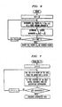
Fig. 1 is a block diagram for computerized processing. -
Fig. 2 is a representation of exemplary annotated pictorial output resulting from such processing. -
Fig. 3 is a flow diagram for feature extraction in processing. -
Fig. 4 is a cartographic grid of a map from which the horizon line is to be extracted. -
Fig. 5 is an elevation corresponding to a strip in the grid ofFig. 4 . -
Fig. 6 is a flow diagram for a method of horizon line extraction. -
Fig. 7 is a flow diagram for matching and annotation processing. -
Fig. 8 is a block diagram for computerized inclusion of radio-transmitted information. -
Fig. 9 is a pictorial representation of automated annotation at a museum. -
Fig. 10 is a pictorial representation of automated annotation at a conference. - Using correspondence matching between cartographic and pictorial data, the pictorial data can be annotated with cartographic data. As illustrated by
Fig. 1 , this technique includes the following procedural steps: (a) based on givencartographic data 1 and viewer position data 2, extracting the viewer environment 3, i.e., of cartographic features which are visible from the viewer position; (b) bringing the extracted cartographic features of the viewer environment into correspondence with features from thepictorial description data 4; (c) annotating the features in thepictorial data 4 based on the viewer environment 3, thus generating an annotatedenvironment description 5; and (d) generating a desired integrated view 6 based on thepictorial data 4 and the annotatedenvironment description 5. - An example of such an integrated view is shown as
Fig. 2 . The topographical features are as in a given image, and the textual annotations are taken from cartographic data. Annotated topographical features include six mountain peaks at the horizon, a lake and a town in the foreground, and a further mountain peak at mid-range. - Further details for the steps of the technique are as follows:
- Given a viewer position, features are identified in the cartographic representation, which are visible from the viewer position. Such features can include the horizon line, specific points on the horizon line, and significant geographical features such as lakes, mountains, forests and buildings, for example. The viewer position may be given as included with the pictorial data from the photographer's knowledge or from a localization system such as G.P.S. (Global Positioning System). Also helpful for present purposes are the viewing angle, e.g. as specified by azimuth and elevation, and the focal length of the view to be annotated.
- From the cartographic data, the technique extracts a description of the viewer environment, resulting in a list of objects in view, together with their respective cartographic positions. This procedure is illustrated by
Fig. 3 . Features represented in the cartographic data are tested for visibility from the viewer position and, for each of the visible features, a table entry is generated including its cartographic position and descriptive information. - Typically, e.g. in extracting the viewer environment for a scenic view, it is important to determine the horizon. A suitable technique for this purpose is illustrated by
Figs. 4-6 . As shown inFig. 4 , with the origin of an x-y-coordinate system chosen at the viewer position O on the map, points Pi = (xi, yi) are identified in a narrow strip S originating at the point O and having azimuth angle Y, say. - The identified points are shown also in
Fig. 5 , which is an elevation along the strip S. Shown further are the vertical coordinates zi corresponding to cartographic altitude. Finding a point of the horizon now amounts to identifying a point (xk, yk) among the points (xi, yi) for which the ratio Zi/(xi 2+yi 2) is maximized. In the present case, point P2 is at the horizon. - To obtain the horizon, the strip is swept through 360 degrees, by successively incrementing the value of Y by a small amount, Δ. This procedure is illustrated by
Fig. 6 . If the view angle is known (at 90 degrees, for example), it suffices to sweep the angle alpha through 180 degrees only. This range may be reduced further if the focal length of the view to be annotated is provided. In some views, such as panoramic silhouettes, the horizon may be the only part of the viewer environment that is of interest. But the present technique is not so limited, as the extracted viewer environment can include visible features below the horizon. And indeed, the technique is applicable whether or not a view has a horizon of interest. - A basic type of correspondence matching is illustrated by
Fig. 7 which also illustrates steps (c) and (d). For each feature in the viewing environment recorded in step (a), a matching feature is found in the image. Alternatively, the extracted list can be globally matched to the pictorial data, by finding the best over-all match of the viewer environment in the image. A global matching measure can be used that takes into account every object and the confidence of each respective match. - As a simple example, in an image as shown in
Fig. 2 , the horizon can be traced readily by known techniques, based on the color or brightness of the sky as compared with the terrain. The traced horizon can be matched to the horizon obtained per (a) above, thus yielding a correspondence between features included in the map and features appearing in the image. - Automated matching can be facilitated by suitable calibration, e.g. by interactive establishment of the correspondence between a small number of distinguished points in the map and the image. For example, a user viewing the map and the image side by side may click first on a point in the map and then on the corresponding point in the image, thus establishing a first correspondence. The greater the number of correspondences thus established, the easier the techniques task of matching.
- Automated matching can be facilitated also if the image is stereographic, i.e. represented by a pair of views from two specified points. Depth information obtained from a stereographic, 3-D view can be used to address ambiguities, which a 2-D view may not resolve. Correspondence matching can be under user control so that a point is annotated in the view when the user clicks on the point.
- Based on the correspondence per (b) above, there results a list of annotations, with each annotation consisting of the cartographic information together with its position in the image.
- Based on their location in the image, the annotations are superposed on the image, resulting in an integrated view. Successive integrated views can be used for browsing and searching, as each movement in the cartographic domain corresponds to a movement in the image domain and vice-versa. The two movements can be visualized together, thus facilitating browsing.
- Another feature of the integrated view is the ability to superimpose different levels of cartographic information onto the picture, both dynamically on a screen or statically for printing. For example, if a view is changed as to focal length as in zooming, different levels of detail in the cartographic data may become relevant for inclusion in the viewer environment.
- As, typically, geographical and pictorial data are supplied at different scales, the method can link annotations obtained at one scale with annotations obtained at other scales. For this purpose, a linked pyramid representation of annotations can be used, in which every annotation has offspring at a finer scale and ancestors at a coarser scale. Offspring of an annotation are more detailed annotations of a geographical object, and an ancestor of an annotation is a common annotation of several geographic objects. Some annotations may originate only at a sufficiently fine scale, as corresponding features may not be recognizable at coarser scales.
- The following are among contemplated applications for the technique: automated generation of panoramic views for atlases, for the promotion of tourism, and for tourist information at popular locations; automated service, e.g. provided on the Internet, for annotating images taken with an electronic camera which also records the viewer position based on G.P.S. input, for example; automated automotive navigation system producing annotated panoramic views rather than mere cartographic views as at present; simulation system producing annotated views of terrain, providing for browsing and searching in cartographic and pictorial domains, with coupling of movement in the two domains; and real-time video system with continuous or intermittent annotation.
- As an example of the use of a real-time video system, in aerial navigation, a helicopter pilot wearing a head-up display viewer (2-D or 3-D) may activate annotation of terrain features in actual view. In annotating, the system can use G.P.S. position information and available cartographic information. In selecting features for annotation, the system can respond to the stance of the pilot's head and/or the pilot's eyes.
- In a further application, a video sequence can be annotated after it has been recorded, e.g. as a travel log. In either case, when annotating a view of a video sequence, correspondence matching between cartographic and pictorial features can take advantage of a correspondence established for a previous view in the sequence. The previous correspondence can serve as an initial guess from which the desired new correspondence can be established by iterative refinement.
- Automated annotation of a view or scene can include highlighting, and inclusion of identifying and/or descriptive information other than cartographic information. An annotation can be generated selectively, e.g. in response to a pointer being positioned, and the annotation can be produced in different sensory forms including visual, auditory and tactile. In the following, element or object will designate anything of interest or potential interest in an image/video scene, to be annotated, highlighted or the like.
-
Fig. 8 illustrates a technique in accordance with an exemplary embodiment of the invention, using radio as well as camera visual, location and direction/orientation input. For objects, radio input provides information concerning their location, as well as meta-information for annotation. Radio input is decoded in module 11. Camera input is of an image representing a view, and of camera parameters from which location, direction and field of view are obtained in module 12. Data from modules 11 and 12 are used inmodule 13 to decide as to which objects are in view. In module 14, objects in view are annotated/highlighted.Module 15 serves for displaying and activating the objects with meta-information. In response to click commands for such objects,module 16 causes their meta-information to be displayed. - Typical ways for identifying an object/element include the following:
- 1. A database can be used for correlating image content with elements in the database, e.g. as described above in cartographic annotation.
- 2. An object in the scene can emit a radio beacon emitting information about the object, e.g. including its position. A portable camera device acquiring the scene can gather the information and place it in the image, based on the location of the object in the image. Establishing a correspondence between object and location in the image can be facilitated by use of emitted position information if available. Also, a camera-acquiring image and beacon signals can be aware of its position and shooting orientation, so that, for placing the information, the camera can indicate the location of the beacon. The information then can be placed at an appropriate location, e.g. the location of the beacon or another suitably related location, e.g. in an image peripherally. A lead line can be included for positive association between an object and its annotation. In a further alternative for placing the information, the camera and radio receiver can locate the beacon through array processing. Among suitable transmission means other than radio are beacons of infrared or ultrasound, as well as established communication channels such as for mobile telephones, for example.
- 3. A base station can be used, for generating dispatching information including a users position relative to objects. The base station can include one or more receivers, with use of at least two receivers being advantageous for triangulation of user(s) and objects. The objects may be active, e.g. as radio sources as described above, or passive, with known location. Then the image/video seen by the user can be annotated by information provided from the base station, and based on camera position and shooting direction. For example, participants in a meeting can be annotated on a live image by tracking their position, so that a speaker using an unfamiliar language can appear as accompanied by a text translation of his words.
- 4. Tracking can be based on visual cues as used in computer vision, either of an object, its environment, or a target placed on the object. The tracked object then can be annotated with relevant meta-information. In a store, for example, if labels on goods are tracked, information can be added on a display concerning promotions and price of objects at which the camera is pointed.
- Tracking methods can be used individually or in combination. Methods can complement each other based on their resolution, e.g. with radio tracking for coarse location and optical for fine localization.
- The following are among ways to annotate or add information to a selected object: (i) making the object clickable, so that, when the object is clicked, additional information will be displayed; (ii) highlighting the object, by segmenting it from the background as additional information is being displayed; (iii) making a list of objects in an image, with associated information, e.g. to display the names of individuals in an image; and (iv) displaying information concerning an object without even displaying the object itself, using any suitable position and data capture technique as described above.
- For bringing objects, their representations, and their associated information into correspondence, centralized or decentralized processing can be employed. For example, in cartographic annotation, all objects are maintained with their coordinates and associated information together in the same database. In decentralized processing this need not be the case, and hybrid arrangements also can be advantageous. For example, the names of restaurants in a locality can be obtained from a database such as the Yellow Pages, their regular menus from separate further databases, and their daily specials dispatched with a beacon.
- An object can be annotated based on the relative position of a display device with respect to the object, including their spatial relationship and the orientation of the device. In case of images or video, the relative position of an element on a screen can be calculated from camera parameters and relative position information of the camera with respect to the element. Where annotation is displayed without displaying an image of the element, the information to be displayed can be selected based on location and orientation of a display device in relation to the element pointed to. Also, a beacon signal can be used that is sufficiently directional and/or having a sufficiently directional capture. The beacon signal can carry identifying information and possibly annotation information.
- Annotation of images and video can be used live, e.g. for training and guidance, and for information services, augmented reality, shopping, and meeting enhancement.
- More specifically as to training and guidance, where a piece of machinery needs to be manufactured or repaired, for example, a database of key points can be interactively pointed out, with associated information. Thus, an assembly worker or repairperson can be trained or guided to perform required actions such as mounting a certain part at its proper location.
- Information services can be implemented so as to avoid unsightly signs and billboards in front of shops and restaurants, e.g. at scenic localities. An annotated image can provide additional information specific to an element, as well as more general information, e.g. tourist information. In another application, in road signaling, signs can be augmented with additional information, e.g. for use by road navigation systems.
- Yet another application is illustrated by
Fig. 9 . In a museum information system, a hand-held device displays an image of a view including artwork on display. The device shows a portrait, annotated with the caption La Joconde, and additional text which may include relevant information such as the name of the artistic author. The device may have a touch screen, for annotation display triggered by touch. Alternatively, e.g. with a mere alphanumeric screen, the display may result upon mere pointing of the device. - In an augmented reality system, specific information about objects, distances, angles, speeds and the like can be included in a live image or video, of interest in navigation systems, for example.
- For shopping, a warehouse, shopping mall or store can be enhanced by supplying additional descriptive and/or price information for an object on an image showing the object.
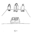
- In a meeting, a participant can use a personal device, which serves as beacon and display as illustrated by
Fig. 10 . When oriented towards another participant, such as here the middle person in the display, a device can include identifying information as annotation of the participant. If the participant speaks in an unfamiliar tongue, automated translation can be displayed in the form of text. - The technique can be implemented for use with a portable device, e.g. a device including a camera in which case a moving image can be annotated. Or, without a camera in a palm device, for example, a fixed view can be shown with annotation. A touch screen can be used, for pointing at an object. Further without requiring a camera, and even with limited display capability as in the case of a portable phone, annotation information can be produced so long as device location and possibly orientation information is available. Then, information can be provided in response to pointing the device. Device pointing may involve other than hand motion, e.g. head motion with virtual reality goggles or glasses, which can show a computer-generated view in combination with a direct view. Such motion may also be of large objects such as a car, ship or plane in automotive, marine and aerial navigation systems.
Claims (14)
- A computerized method for annotating an element of a view, comprising the steps of:(a) obtaining an identification of the element;(b) relating the identification to annotating data associated with the element; and(c) causing the data to be displayed.
- The method of claim 1, wherein the identification has made use of a device pointed at the element.
- The method of claim 1, wherein an image of said view is taken with a portable device including a camera and a touch screen;
and wherein annotation information is based on the device position and orientation. - The method of claim 3, wherein an object is annotated based on the relative position of the device with respect to the object, including their spatial relationship and the orientation of the device.
- The method of claim 4, further comprising making the object clickable, so that, when the object is clicked, additional information will be displayed.
- The method of claim 1, wherein the identification has made use of a signal from the element, and wherein the signal is one of a radio signal, or mobile-telephone signal.
- The method of claim 1, wherein obtaining the identification comprises processing a signal which relates to a representation of the element.
- The method of claim 1, wherein relating the identification to data comprises referring to a database.
- The method of claim 1, wherein relating the identification to data comprises receiving the data as a signal from the element.
- The method of claim 9, wherein the signal from the element has been located using array processing.
- The method of one of the claims 1 to 10, wherein the view is of participants in a meeting.
- A system for annotating an element of a view, comprising:(a) means for obtaining a view by a device;(b) means for obtaining an identification of the element;(c) means for relating the identification to annotating data associated with the element; and(d) means for causing the data to be displayed.
- The system of claim 12, wherein said device is a portable device including a camera and a touch screen;
and wherein annotation information is based on the device position and orientation. - The system of claim 12, comprising means for determining the relative position of the device with respect to an object, and means for basing the annotation on said relative position of the device with respect to an object, including their spatial relationship and the orientation of the device.
Applications Claiming Priority (2)
| Application Number | Priority Date | Filing Date | Title |
|---|---|---|---|
| US09/817,314 US8432414B2 (en) | 1997-09-05 | 2001-03-26 | Automated annotation of a view |
| EP02006821A EP1246080B1 (en) | 2001-03-26 | 2002-03-25 | Automated annotation of a view |
Related Parent Applications (2)
| Application Number | Title | Priority Date | Filing Date |
|---|---|---|---|
| EP02006821.9 Division | 2002-03-25 | ||
| EP02006821A Division EP1246080B1 (en) | 2001-03-26 | 2002-03-25 | Automated annotation of a view |
Publications (2)
| Publication Number | Publication Date |
|---|---|
| EP2207113A1 true EP2207113A1 (en) | 2010-07-14 |
| EP2207113B1 EP2207113B1 (en) | 2015-11-11 |
Family
ID=25222797
Family Applications (2)
| Application Number | Title | Priority Date | Filing Date |
|---|---|---|---|
| EP10161664.7A Expired - Lifetime EP2207113B1 (en) | 2001-03-26 | 2002-03-25 | Automated annotation of a view |
| EP02006821A Expired - Lifetime EP1246080B1 (en) | 2001-03-26 | 2002-03-25 | Automated annotation of a view |
Family Applications After (1)
| Application Number | Title | Priority Date | Filing Date |
|---|---|---|---|
| EP02006821A Expired - Lifetime EP1246080B1 (en) | 2001-03-26 | 2002-03-25 | Automated annotation of a view |
Country Status (5)
| Country | Link |
|---|---|
| US (2) | US8432414B2 (en) |
| EP (2) | EP2207113B1 (en) |
| AT (1) | ATE467189T1 (en) |
| DE (1) | DE60236234D1 (en) |
| ES (1) | ES2558255T3 (en) |
Cited By (9)
| Publication number | Priority date | Publication date | Assignee | Title |
|---|---|---|---|---|
| WO2012084362A1 (en) | 2010-12-21 | 2012-06-28 | Ecole polytechnique fédérale de Lausanne (EPFL) | Computerized method and device for annotating at least one feature of an image of a view |
| US8605141B2 (en) | 2010-02-24 | 2013-12-10 | Nant Holdings Ip, Llc | Augmented reality panorama supporting visually impaired individuals |
| WO2014053194A1 (en) | 2012-10-05 | 2014-04-10 | Vidinoti Sa | Annotation method and apparatus |
| WO2014094874A1 (en) | 2012-12-21 | 2014-06-26 | Vidinoti Sa | Method and apparatus for adding annotations to a plenoptic light field |
| US8810598B2 (en) | 2011-04-08 | 2014-08-19 | Nant Holdings Ip, Llc | Interference based augmented reality hosting platforms |
| EP2420923A3 (en) * | 2010-08-16 | 2014-10-15 | LG Electronics Inc. | Method and displaying information and mobile terminal using the same |
| US9237263B2 (en) | 2012-10-05 | 2016-01-12 | Vidinoti Sa | Annotation method and apparatus |
| US9613256B2 (en) | 2013-06-12 | 2017-04-04 | Ecole Polytechnique Federale De Lausanne (Epfl) | Method and apparatus for identifying local features |
| US10140317B2 (en) | 2013-10-17 | 2018-11-27 | Nant Holdings Ip, Llc | Wide area augmented reality location-based services |
Families Citing this family (71)
| Publication number | Priority date | Publication date | Assignee | Title |
|---|---|---|---|---|
| JP2004534963A (en) * | 2001-03-30 | 2004-11-18 | コーニンクレッカ フィリップス エレクトロニクス エヌ ヴィ | Methods, systems and devices for augmented reality |
| GB2383247A (en) * | 2001-12-13 | 2003-06-18 | Hewlett Packard Co | Multi-modal picture allowing verbal interaction between a user and the picture |
| GB0129787D0 (en) * | 2001-12-13 | 2002-01-30 | Hewlett Packard Co | Method and system for collecting user-interest information regarding a picture |
| US7823058B2 (en) * | 2002-12-30 | 2010-10-26 | The Board Of Trustees Of The Leland Stanford Junior University | Methods and apparatus for interactive point-of-view authoring of digital video content |
| JP4864295B2 (en) * | 2003-06-02 | 2012-02-01 | 富士フイルム株式会社 | Image display system, image display apparatus, and program |
| US7190496B2 (en) * | 2003-07-24 | 2007-03-13 | Zebra Imaging, Inc. | Enhanced environment visualization using holographic stereograms |
| US7995090B2 (en) * | 2003-07-28 | 2011-08-09 | Fuji Xerox Co., Ltd. | Video enabled tele-presence control host |
| CN100433050C (en) * | 2004-01-08 | 2008-11-12 | 日本电气株式会社 | Mobile communication system, mobile terminal device, fixed station device, character recognition device and method, and program |
| US20050209849A1 (en) * | 2004-03-22 | 2005-09-22 | Sony Corporation And Sony Electronics Inc. | System and method for automatically cataloguing data by utilizing speech recognition procedures |
| US20050216464A1 (en) * | 2004-03-27 | 2005-09-29 | Microsoft Corporation | Automated authoring tool and method to facilitate inclusion of maps and other geographical data into travelogues |
| WO2005124594A1 (en) * | 2004-06-16 | 2005-12-29 | Koninklijke Philips Electronics, N.V. | Automatic, real-time, superimposed labeling of points and objects of interest within a view |
| US8547401B2 (en) | 2004-08-19 | 2013-10-01 | Sony Computer Entertainment Inc. | Portable augmented reality device and method |
| GB0502844D0 (en) | 2005-02-11 | 2005-03-16 | Univ Edinburgh | Storing digital content for access using a captured image |
| US20070166671A1 (en) * | 2005-12-20 | 2007-07-19 | Peter Walter | Display device |
| US7836437B2 (en) * | 2006-02-10 | 2010-11-16 | Microsoft Corporation | Semantic annotations for virtual objects |
| JP2009530661A (en) * | 2006-03-15 | 2009-08-27 | ゼブラ・イメージング・インコーポレイテッド | Dynamic autostereoscopic display |
| US20080144174A1 (en) * | 2006-03-15 | 2008-06-19 | Zebra Imaging, Inc. | Dynamic autostereoscopic displays |
| US9843790B2 (en) | 2006-03-15 | 2017-12-12 | Fovi 3D, Inc. | Dynamic autostereoscopic displays |
| KR100775354B1 (en) | 2006-04-27 | 2007-11-09 | 팅크웨어(주) | Method for providing navigation background information and navigation system using the same |
| DE102006062061B4 (en) * | 2006-12-29 | 2010-06-10 | Fraunhofer-Gesellschaft zur Förderung der angewandten Forschung e.V. | Apparatus, method and computer program for determining a position based on a camera image from a camera |
| BRPI0812782B1 (en) * | 2007-05-31 | 2019-01-22 | Panasonic Corp | image capture apparatus, additional information provision apparatus and method for use in an additional information provision apparatus |
| US8994851B2 (en) * | 2007-08-07 | 2015-03-31 | Qualcomm Incorporated | Displaying image data and geographic element data |
| US9329052B2 (en) * | 2007-08-07 | 2016-05-03 | Qualcomm Incorporated | Displaying image data and geographic element data |
| US8713421B2 (en) * | 2007-08-28 | 2014-04-29 | Autodesk, Inc. | Scale information for drawing annotations |
| US8180396B2 (en) | 2007-10-18 | 2012-05-15 | Yahoo! Inc. | User augmented reality for camera-enabled mobile devices |
| CA2643570C (en) * | 2007-11-08 | 2013-01-22 | Carole Moquin | Virtual environment simulating travel by various modes of transportation |
| US8131750B2 (en) * | 2007-12-28 | 2012-03-06 | Microsoft Corporation | Real-time annotator |
| US8116596B2 (en) * | 2008-01-30 | 2012-02-14 | Eastman Kodak Company | Recognizing image environment from image and position |
| US8711176B2 (en) | 2008-05-22 | 2014-04-29 | Yahoo! Inc. | Virtual billboards |
| US20090289955A1 (en) * | 2008-05-22 | 2009-11-26 | Yahoo! Inc. | Reality overlay device |
| CN102015410B (en) * | 2008-06-03 | 2013-12-11 | 三菱电机株式会社 | In-train information delivery service system, in-train information delivery method, and information display unit for passenger-carrying car |
| WO2010012310A1 (en) * | 2008-07-31 | 2010-02-04 | Tele Atlas B.V. | Method of displaying navigation data in 3d |
| KR101661269B1 (en) * | 2008-09-02 | 2016-09-29 | 에꼴 뽈리떼끄닉 뻬데랄 드 로잔느 (으뻬에프엘) | Image Annotation on Portable Devices |
| JP5293025B2 (en) | 2008-09-11 | 2013-09-18 | ブラザー工業株式会社 | Head mounted display |
| US20100085350A1 (en) * | 2008-10-02 | 2010-04-08 | Microsoft Corporation | Oblique display with additional detail |
| KR101554643B1 (en) * | 2009-02-17 | 2015-09-21 | 삼성전자주식회사 | Apparatus and method for automatic transmitting emoticon in video telephony of mobile communication terminal |
| IT1399396B1 (en) * | 2009-06-23 | 2013-04-16 | Midulla | METHOD AND IDENTIFICATION SYSTEM OF OBJECTS PRESENT IN A PHOTO OR A DIGITAL VIDEO |
| US8427508B2 (en) * | 2009-06-25 | 2013-04-23 | Nokia Corporation | Method and apparatus for an augmented reality user interface |
| US8083149B2 (en) * | 2009-11-05 | 2011-12-27 | Hand Held Products, Inc. | Annotation of optical images on a mobile device |
| KR20110087530A (en) * | 2010-01-26 | 2011-08-03 | 주식회사 팬택 | Mobile communication terminal able to obtain position information for an object and method for obtaining information of the object used mobile communication terminal |
| DE102010010951A1 (en) * | 2010-03-10 | 2011-09-15 | Astrium Gmbh | The information reproducing apparatus |
| KR101669119B1 (en) * | 2010-12-14 | 2016-10-25 | 삼성전자주식회사 | System and method for multi-layered augmented reality |
| US10455089B2 (en) * | 2011-03-22 | 2019-10-22 | Fmr Llc | Augmented reality system for product selection |
| US10114451B2 (en) | 2011-03-22 | 2018-10-30 | Fmr Llc | Augmented reality in a virtual tour through a financial portfolio |
| US8644673B2 (en) | 2011-03-22 | 2014-02-04 | Fmr Llc | Augmented reality system for re-casting a seminar with private calculations |
| US9921641B1 (en) * | 2011-06-10 | 2018-03-20 | Amazon Technologies, Inc. | User/object interactions in an augmented reality environment |
| US9996972B1 (en) * | 2011-06-10 | 2018-06-12 | Amazon Technologies, Inc. | User/object interactions in an augmented reality environment |
| US10008037B1 (en) | 2011-06-10 | 2018-06-26 | Amazon Technologies, Inc. | User/object interactions in an augmented reality environment |
| CN102237010B (en) * | 2011-07-28 | 2015-07-15 | 中国测绘科学研究院 | Annotation method for complicated linear elements |
| WO2013068429A1 (en) | 2011-11-08 | 2013-05-16 | Vidinoti Sa | Image annotation method and system |
| CN103177034B (en) * | 2011-12-23 | 2016-03-30 | 上海优途信息科技有限公司 | The generation method of parallel lines and device in a kind of road network |
| US20130328930A1 (en) * | 2012-06-06 | 2013-12-12 | Samsung Electronics Co., Ltd. | Apparatus and method for providing augmented reality service |
| WO2014059387A2 (en) * | 2012-10-11 | 2014-04-17 | Imsi Design, Llc | Method of annotating a document displayed on an electronic device |
| CN103335645B (en) * | 2013-06-04 | 2015-10-07 | 东南大学 | The pinpoint image acquiring method in space towards landscape planning |
| US10168871B2 (en) * | 2013-09-16 | 2019-01-01 | Rovi Guides, Inc. | Methods and systems for presenting direction-specific media assets |
| US20160342839A1 (en) * | 2014-03-20 | 2016-11-24 | Hewlett Packard Enterprise Development Lp | Identifying electronic components for augmented reality |
| CN105338479B (en) | 2014-06-09 | 2020-03-10 | 阿里巴巴集团控股有限公司 | Information processing method and device based on places |
| US10816638B2 (en) * | 2014-09-16 | 2020-10-27 | Symbol Technologies, Llc | Ultrasonic locationing interleaved with alternate audio functions |
| JP6468656B2 (en) * | 2015-09-30 | 2019-02-13 | Kddi株式会社 | AR information display device |
| CN106971129A (en) * | 2016-01-13 | 2017-07-21 | 深圳超多维光电子有限公司 | The application process and device of a kind of 3D rendering |
| US10460457B2 (en) * | 2016-07-12 | 2019-10-29 | Novartis Ag | Adaptive adjustment of overlay image parameters |
| TWI611307B (en) * | 2016-08-24 | 2018-01-11 | 李雨暹 | Method for establishing location-based space object, method for displaying space object, and application system thereof |
| JP6832794B2 (en) * | 2017-06-05 | 2021-02-24 | ルネサスエレクトロニクス株式会社 | Wireless communication system |
| US10430987B1 (en) * | 2017-06-09 | 2019-10-01 | Snap Inc. | Annotating an image with a texture fill |
| US10508925B2 (en) * | 2017-08-31 | 2019-12-17 | Uber Technologies, Inc. | Pickup location selection and augmented reality navigation |
| CN109584295B (en) * | 2017-09-29 | 2022-08-26 | 阿里巴巴集团控股有限公司 | Method, device and system for automatically labeling target object in image |
| US11218639B1 (en) * | 2018-10-12 | 2022-01-04 | Staples, Inc. | Mobile interface for marking and organizing images |
| US10740615B2 (en) | 2018-11-20 | 2020-08-11 | Uber Technologies, Inc. | Mutual augmented reality experience for users in a network system |
| US11631119B2 (en) | 2019-01-11 | 2023-04-18 | Target Brands, Inc. | Electronic product recognition |
| US11436826B2 (en) | 2019-01-11 | 2022-09-06 | Target Brands, Inc. | Augmented reality experience for shopping |
| US11461974B2 (en) | 2020-07-31 | 2022-10-04 | Arknet Inc. | System and method for creating geo-located augmented reality communities |
Citations (3)
| Publication number | Priority date | Publication date | Assignee | Title |
|---|---|---|---|---|
| WO1995020799A1 (en) * | 1994-01-28 | 1995-08-03 | Hughes Aircraft Company | A method for automatically displaying map symbols |
| EP0867690A1 (en) | 1997-03-27 | 1998-09-30 | Nippon Telegraph And Telephone Corporation | Device and system for labeling sight images |
| WO1998055833A1 (en) * | 1997-06-03 | 1998-12-10 | Stephen Bide | Portable navigation system comprising direction detector, position detector and database |
Family Cites Families (31)
| Publication number | Priority date | Publication date | Assignee | Title |
|---|---|---|---|---|
| JPS60200379A (en) * | 1984-03-26 | 1985-10-09 | Hitachi Ltd | Segmentation device for picture processing |
| JPH0644292B2 (en) * | 1984-07-09 | 1994-06-08 | オムロン株式会社 | Two-dimensional visual recognition device |
| EP0298250B1 (en) * | 1987-07-10 | 1992-05-06 | Siemens Aktiengesellschaft | Versatile recognition of object structures in colour and grey value images |
| US5544045A (en) * | 1991-10-30 | 1996-08-06 | Canon Inc. | Unified scanner computer printer |
| US5815411A (en) * | 1993-09-10 | 1998-09-29 | Criticom Corporation | Electro-optic vision system which exploits position and attitude |
| JP2521035B2 (en) * | 1993-12-03 | 1996-07-31 | インターナショナル・ビジネス・マシーンズ・コーポレイション | Placing annotations on the display |
| US5526478A (en) * | 1994-06-30 | 1996-06-11 | Silicon Graphics, Inc. | Three dimensional model with three dimensional pointers and multimedia functions linked to the pointers |
| GB9422012D0 (en) * | 1994-11-01 | 1994-12-21 | Rank Xerox Ltd | Document processing and data distribution system |
| US5729471A (en) * | 1995-03-31 | 1998-03-17 | The Regents Of The University Of California | Machine dynamic selection of one video camera/image of a scene from multiple video cameras/images of the scene in accordance with a particular perspective on the scene, an object in the scene, or an event in the scene |
| US5717406A (en) * | 1995-06-07 | 1998-02-10 | Sanconix Inc. | Enhanced position calculation |
| US6181302B1 (en) * | 1996-04-24 | 2001-01-30 | C. Macgill Lynde | Marine navigation binoculars with virtual display superimposing real world image |
| US5737491A (en) * | 1996-06-28 | 1998-04-07 | Eastman Kodak Company | Electronic imaging system capable of image capture, local wireless transmission and voice recognition |
| US5689472A (en) * | 1996-10-31 | 1997-11-18 | Silicon Magic Corporation | System and method for providing efficient access to a memory bank |
| JP2927350B2 (en) * | 1997-03-27 | 1999-07-28 | 株式会社モノリス | Multi-resolution filter processing method and image matching method using the method |
| US6154788A (en) * | 1997-04-25 | 2000-11-28 | Simple Technology, Inc. | Multi-function module incorporating flash memory having additional controller adapted to configure the data from the memory that is to be provided to the external source |
| JP3586361B2 (en) * | 1997-07-23 | 2004-11-10 | 新キャタピラー三菱株式会社 | Security mobile phone system |
| US6292830B1 (en) * | 1997-08-08 | 2001-09-18 | Iterations Llc | System for optimizing interaction among agents acting on multiple levels |
| US6208353B1 (en) * | 1997-09-05 | 2001-03-27 | ECOLE POLYTECHNIQUE FEDéRALE DE LAUSANNE | Automated cartographic annotation of digital images |
| US6327594B1 (en) * | 1999-01-29 | 2001-12-04 | International Business Machines Corporation | Methods for shared data management in a pervasive computing environment |
| US6587601B1 (en) * | 1999-06-29 | 2003-07-01 | Sarnoff Corporation | Method and apparatus for performing geo-spatial registration using a Euclidean representation |
| US6401105B1 (en) * | 1999-07-08 | 2002-06-04 | Telescan, Inc. | Adaptive textual system for associating descriptive text with varying data |
| US6307573B1 (en) * | 1999-07-22 | 2001-10-23 | Barbara L. Barros | Graphic-information flow method and system for visually analyzing patterns and relationships |
| US6330356B1 (en) * | 1999-09-29 | 2001-12-11 | Rockwell Science Center Llc | Dynamic visual registration of a 3-D object with a graphical model |
| US6611725B1 (en) * | 2000-02-03 | 2003-08-26 | Solidworks Corporation | Computer drawing system |
| KR100359770B1 (en) * | 2000-03-02 | 2002-11-04 | 주식회사 하이닉스반도체 | Active pixel circuit in CMOS image sensor |
| US6895126B2 (en) * | 2000-10-06 | 2005-05-17 | Enrico Di Bernardo | System and method for creating, storing, and utilizing composite images of a geographic location |
| US6904392B1 (en) * | 2000-10-13 | 2005-06-07 | Dassault Systemes | Annotation management |
| US6765569B2 (en) * | 2001-03-07 | 2004-07-20 | University Of Southern California | Augmented-reality tool employing scene-feature autocalibration during camera motion |
| US7751805B2 (en) * | 2004-02-20 | 2010-07-06 | Google Inc. | Mobile image-based information retrieval system |
| US7835577B2 (en) * | 2005-01-18 | 2010-11-16 | Siemens Corporation | System and method for multi-label image segmentation of digital photographs |
| US7840059B2 (en) * | 2006-09-21 | 2010-11-23 | Microsoft Corporation | Object recognition using textons and shape filters |
-
2001
- 2001-03-26 US US09/817,314 patent/US8432414B2/en not_active Expired - Lifetime
-
2002
- 2002-03-25 DE DE60236234T patent/DE60236234D1/en not_active Expired - Lifetime
- 2002-03-25 EP EP10161664.7A patent/EP2207113B1/en not_active Expired - Lifetime
- 2002-03-25 ES ES10161664.7T patent/ES2558255T3/en not_active Expired - Lifetime
- 2002-03-25 EP EP02006821A patent/EP1246080B1/en not_active Expired - Lifetime
- 2002-03-25 AT AT02006821T patent/ATE467189T1/en not_active IP Right Cessation
-
2012
- 2012-03-28 US US13/432,952 patent/US8675016B2/en not_active Expired - Fee Related
Patent Citations (3)
| Publication number | Priority date | Publication date | Assignee | Title |
|---|---|---|---|---|
| WO1995020799A1 (en) * | 1994-01-28 | 1995-08-03 | Hughes Aircraft Company | A method for automatically displaying map symbols |
| EP0867690A1 (en) | 1997-03-27 | 1998-09-30 | Nippon Telegraph And Telephone Corporation | Device and system for labeling sight images |
| WO1998055833A1 (en) * | 1997-06-03 | 1998-12-10 | Stephen Bide | Portable navigation system comprising direction detector, position detector and database |
Cited By (27)
| Publication number | Priority date | Publication date | Assignee | Title |
|---|---|---|---|---|
| US8605141B2 (en) | 2010-02-24 | 2013-12-10 | Nant Holdings Ip, Llc | Augmented reality panorama supporting visually impaired individuals |
| US11348480B2 (en) | 2010-02-24 | 2022-05-31 | Nant Holdings Ip, Llc | Augmented reality panorama systems and methods |
| US10535279B2 (en) | 2010-02-24 | 2020-01-14 | Nant Holdings Ip, Llc | Augmented reality panorama supporting visually impaired individuals |
| US9526658B2 (en) | 2010-02-24 | 2016-12-27 | Nant Holdings Ip, Llc | Augmented reality panorama supporting visually impaired individuals |
| EP2420923A3 (en) * | 2010-08-16 | 2014-10-15 | LG Electronics Inc. | Method and displaying information and mobile terminal using the same |
| EP3678035A1 (en) | 2010-12-21 | 2020-07-08 | QUALCOMM Incorporated | Computerized method and device for annotating at least one feature of an image of a view |
| US9959644B2 (en) | 2010-12-21 | 2018-05-01 | Qualcomm Incorporated | Computerized method and device for annotating at least one feature of an image of a view |
| WO2012084362A1 (en) | 2010-12-21 | 2012-06-28 | Ecole polytechnique fédérale de Lausanne (EPFL) | Computerized method and device for annotating at least one feature of an image of a view |
| US8810598B2 (en) | 2011-04-08 | 2014-08-19 | Nant Holdings Ip, Llc | Interference based augmented reality hosting platforms |
| US10726632B2 (en) | 2011-04-08 | 2020-07-28 | Nant Holdings Ip, Llc | Interference based augmented reality hosting platforms |
| US11869160B2 (en) | 2011-04-08 | 2024-01-09 | Nant Holdings Ip, Llc | Interference based augmented reality hosting platforms |
| US9824501B2 (en) | 2011-04-08 | 2017-11-21 | Nant Holdings Ip, Llc | Interference based augmented reality hosting platforms |
| US9396589B2 (en) | 2011-04-08 | 2016-07-19 | Nant Holdings Ip, Llc | Interference based augmented reality hosting platforms |
| US10127733B2 (en) | 2011-04-08 | 2018-11-13 | Nant Holdings Ip, Llc | Interference based augmented reality hosting platforms |
| US11854153B2 (en) | 2011-04-08 | 2023-12-26 | Nant Holdings Ip, Llc | Interference based augmented reality hosting platforms |
| US10403051B2 (en) | 2011-04-08 | 2019-09-03 | Nant Holdings Ip, Llc | Interference based augmented reality hosting platforms |
| US11514652B2 (en) | 2011-04-08 | 2022-11-29 | Nant Holdings Ip, Llc | Interference based augmented reality hosting platforms |
| US11107289B2 (en) | 2011-04-08 | 2021-08-31 | Nant Holdings Ip, Llc | Interference based augmented reality hosting platforms |
| US11967034B2 (en) | 2011-04-08 | 2024-04-23 | Nant Holdings Ip, Llc | Augmented reality object management system |
| WO2014053194A1 (en) | 2012-10-05 | 2014-04-10 | Vidinoti Sa | Annotation method and apparatus |
| CN104798128A (en) * | 2012-10-05 | 2015-07-22 | 维迪诺蒂有限公司 | Annotation method and apparatus |
| US9237263B2 (en) | 2012-10-05 | 2016-01-12 | Vidinoti Sa | Annotation method and apparatus |
| WO2014094874A1 (en) | 2012-12-21 | 2014-06-26 | Vidinoti Sa | Method and apparatus for adding annotations to a plenoptic light field |
| US9613256B2 (en) | 2013-06-12 | 2017-04-04 | Ecole Polytechnique Federale De Lausanne (Epfl) | Method and apparatus for identifying local features |
| US10664518B2 (en) | 2013-10-17 | 2020-05-26 | Nant Holdings Ip, Llc | Wide area augmented reality location-based services |
| US11392636B2 (en) | 2013-10-17 | 2022-07-19 | Nant Holdings Ip, Llc | Augmented reality position-based service, methods, and systems |
| US10140317B2 (en) | 2013-10-17 | 2018-11-27 | Nant Holdings Ip, Llc | Wide area augmented reality location-based services |
Also Published As
| Publication number | Publication date |
|---|---|
| ATE467189T1 (en) | 2010-05-15 |
| ES2558255T3 (en) | 2016-02-02 |
| US8432414B2 (en) | 2013-04-30 |
| EP1246080B1 (en) | 2010-05-05 |
| US8675016B2 (en) | 2014-03-18 |
| US20120212507A1 (en) | 2012-08-23 |
| DE60236234D1 (en) | 2010-06-17 |
| EP1246080A2 (en) | 2002-10-02 |
| EP1246080A3 (en) | 2006-01-11 |
| EP2207113B1 (en) | 2015-11-11 |
| US20020075282A1 (en) | 2002-06-20 |
Similar Documents
| Publication | Publication Date | Title |
|---|---|---|
| EP2207113B1 (en) | Automated annotation of a view | |
| US6208353B1 (en) | Automated cartographic annotation of digital images | |
| US7966024B2 (en) | Virtual skywriting | |
| CN104748738B (en) | Indoor positioning air navigation aid and system | |
| US8280405B2 (en) | Location based wireless collaborative environment with a visual user interface | |
| CN102194007B (en) | System and method for acquiring mobile augmented reality information | |
| US9779553B2 (en) | System and method for defining an augmented reality view in a specific location | |
| JP5582548B2 (en) | Display method of virtual information in real environment image | |
| US8218943B2 (en) | CV tag video image display device provided with layer generating and selection functions | |
| US10868977B2 (en) | Information processing apparatus, information processing method, and program capable of adaptively displaying a video corresponding to sensed three-dimensional information | |
| US20100287500A1 (en) | Method and system for displaying conformal symbology on a see-through display | |
| KR20090073140A (en) | Video surveillance system providing tracking of a moving object in a geospatial model and related methods | |
| IL169934A (en) | Real-time geographic information system and method | |
| KR20150075532A (en) | Apparatus and Method of Providing AR | |
| US20100134486A1 (en) | Automated Display and Manipulation of Photos and Video Within Geographic Software | |
| CN111242704A (en) | Method and electronic equipment for superposing live character images in real scene | |
| CN112714266A (en) | Method and device for displaying label information, electronic equipment and storage medium | |
| JP3156646B2 (en) | Search-type landscape labeling device and system | |
| JP2000050156A (en) | News supporting system | |
| JP3156645B2 (en) | Information transmission type landscape labeling device and system | |
| KR20160138823A (en) | Method for providing information of traditional market using augmented reality | |
| Mori et al. | An overview of augmented visualization: observing the real world as desired | |
| CN113012032A (en) | Aerial panoramic image display method capable of automatically labeling place names | |
| KR100231712B1 (en) | A design of system architecture and operation for unmanned aero vehicle system | |
| CN113066193B (en) | Method for enhancing reality on live-action three-dimensional map |
Legal Events
| Date | Code | Title | Description |
|---|---|---|---|
| PUAI | Public reference made under article 153(3) epc to a published international application that has entered the european phase |
Free format text: ORIGINAL CODE: 0009012 |
|
| 17P | Request for examination filed |
Effective date: 20100430 |
|
| AC | Divisional application: reference to earlier application |
Ref document number: 1246080 Country of ref document: EP Kind code of ref document: P |
|
| AK | Designated contracting states |
Kind code of ref document: A1 Designated state(s): AT BE CH CY DE DK ES FI FR GB GR IE IT LI LU MC NL PT SE TR |
|
| RIN1 | Information on inventor provided before grant (corrected) |
Inventor name: VETTERLI, MARTIN Inventor name: AYER, SERGE |
|
| 17Q | First examination report despatched |
Effective date: 20110510 |
|
| RAP1 | Party data changed (applicant data changed or rights of an application transferred) |
Owner name: VIDINOTI SA |
|
| REG | Reference to a national code |
Ref country code: DE Ref legal event code: R079 Ref document number: 60247627 Country of ref document: DE Free format text: PREVIOUS MAIN CLASS: G06F0017300000 Ipc: G01C0021200000 |
|
| GRAP | Despatch of communication of intention to grant a patent |
Free format text: ORIGINAL CODE: EPIDOSNIGR1 |
|
| RIC1 | Information provided on ipc code assigned before grant |
Ipc: G09B 29/00 20060101ALI20150430BHEP Ipc: G06F 17/30 20060101ALI20150430BHEP Ipc: G06K 9/00 20060101ALI20150430BHEP Ipc: G09B 29/10 20060101ALI20150430BHEP Ipc: G06T 11/60 20060101ALI20150430BHEP Ipc: G01C 21/20 20060101AFI20150430BHEP Ipc: G06T 15/00 20110101ALI20150430BHEP Ipc: G01C 21/36 20060101ALI20150430BHEP |
|
| INTG | Intention to grant announced |
Effective date: 20150521 |
|
| RAP1 | Party data changed (applicant data changed or rights of an application transferred) |
Owner name: QUALCOMM CONNECTED EXPERIENCES, INC. |
|
| GRAS | Grant fee paid |
Free format text: ORIGINAL CODE: EPIDOSNIGR3 |
|
| GRAA | (expected) grant |
Free format text: ORIGINAL CODE: 0009210 |
|
| RAP1 | Party data changed (applicant data changed or rights of an application transferred) |
Owner name: QUALCOMM INCORPORATED |
|
| AC | Divisional application: reference to earlier application |
Ref document number: 1246080 Country of ref document: EP Kind code of ref document: P |
|
| AK | Designated contracting states |
Kind code of ref document: B1 Designated state(s): AT BE CH CY DE DK ES FI FR GB GR IE IT LI LU MC NL PT SE TR |
|
| REG | Reference to a national code |
Ref country code: GB Ref legal event code: FG4D |
|
| REG | Reference to a national code |
Ref country code: CH Ref legal event code: EP |
|
| REG | Reference to a national code |
Ref country code: IE Ref legal event code: FG4D |
|
| REG | Reference to a national code |
Ref country code: FR Ref legal event code: PLFP Year of fee payment: 15 |
|
| REG | Reference to a national code |
Ref country code: AT Ref legal event code: REF Ref document number: 760680 Country of ref document: AT Kind code of ref document: T Effective date: 20151215 |
|
| REG | Reference to a national code |
Ref country code: DE Ref legal event code: R096 Ref document number: 60247627 Country of ref document: DE |
|
| REG | Reference to a national code |
Ref country code: ES Ref legal event code: FG2A Ref document number: 2558255 Country of ref document: ES Kind code of ref document: T3 Effective date: 20160202 |
|
| REG | Reference to a national code |
Ref country code: NL Ref legal event code: FP |
|
| REG | Reference to a national code |
Ref country code: AT Ref legal event code: MK05 Ref document number: 760680 Country of ref document: AT Kind code of ref document: T Effective date: 20151111 |
|
| PG25 | Lapsed in a contracting state [announced via postgrant information from national office to epo] |
Ref country code: AT Free format text: LAPSE BECAUSE OF FAILURE TO SUBMIT A TRANSLATION OF THE DESCRIPTION OR TO PAY THE FEE WITHIN THE PRESCRIBED TIME-LIMIT Effective date: 20151111 Ref country code: FI Free format text: LAPSE BECAUSE OF FAILURE TO SUBMIT A TRANSLATION OF THE DESCRIPTION OR TO PAY THE FEE WITHIN THE PRESCRIBED TIME-LIMIT Effective date: 20151111 Ref country code: GR Free format text: LAPSE BECAUSE OF FAILURE TO SUBMIT A TRANSLATION OF THE DESCRIPTION OR TO PAY THE FEE WITHIN THE PRESCRIBED TIME-LIMIT Effective date: 20160212 Ref country code: SE Free format text: LAPSE BECAUSE OF FAILURE TO SUBMIT A TRANSLATION OF THE DESCRIPTION OR TO PAY THE FEE WITHIN THE PRESCRIBED TIME-LIMIT Effective date: 20151111 Ref country code: PT Free format text: LAPSE BECAUSE OF FAILURE TO SUBMIT A TRANSLATION OF THE DESCRIPTION OR TO PAY THE FEE WITHIN THE PRESCRIBED TIME-LIMIT Effective date: 20160311 |
|
| REG | Reference to a national code |
Ref country code: DE Ref legal event code: R097 Ref document number: 60247627 Country of ref document: DE |
|
| PG25 | Lapsed in a contracting state [announced via postgrant information from national office to epo] |
Ref country code: DK Free format text: LAPSE BECAUSE OF FAILURE TO SUBMIT A TRANSLATION OF THE DESCRIPTION OR TO PAY THE FEE WITHIN THE PRESCRIBED TIME-LIMIT Effective date: 20151111 Ref country code: BE Free format text: LAPSE BECAUSE OF NON-PAYMENT OF DUE FEES Effective date: 20160331 |
|
| PLBE | No opposition filed within time limit |
Free format text: ORIGINAL CODE: 0009261 |
|
| STAA | Information on the status of an ep patent application or granted ep patent |
Free format text: STATUS: NO OPPOSITION FILED WITHIN TIME LIMIT |
|
| 26N | No opposition filed |
Effective date: 20160812 |
|
| PG25 | Lapsed in a contracting state [announced via postgrant information from national office to epo] |
Ref country code: LU Free format text: LAPSE BECAUSE OF FAILURE TO SUBMIT A TRANSLATION OF THE DESCRIPTION OR TO PAY THE FEE WITHIN THE PRESCRIBED TIME-LIMIT Effective date: 20160325 Ref country code: MC Free format text: LAPSE BECAUSE OF FAILURE TO SUBMIT A TRANSLATION OF THE DESCRIPTION OR TO PAY THE FEE WITHIN THE PRESCRIBED TIME-LIMIT Effective date: 20151111 |
|
| REG | Reference to a national code |
Ref country code: CH Ref legal event code: PL |
|
| REG | Reference to a national code |
Ref country code: IE Ref legal event code: MM4A |
|
| PG25 | Lapsed in a contracting state [announced via postgrant information from national office to epo] |
Ref country code: BE Free format text: LAPSE BECAUSE OF FAILURE TO SUBMIT A TRANSLATION OF THE DESCRIPTION OR TO PAY THE FEE WITHIN THE PRESCRIBED TIME-LIMIT Effective date: 20151111 |
|
| PG25 | Lapsed in a contracting state [announced via postgrant information from national office to epo] |
Ref country code: LI Free format text: LAPSE BECAUSE OF NON-PAYMENT OF DUE FEES Effective date: 20160331 Ref country code: CH Free format text: LAPSE BECAUSE OF NON-PAYMENT OF DUE FEES Effective date: 20160331 Ref country code: IE Free format text: LAPSE BECAUSE OF NON-PAYMENT OF DUE FEES Effective date: 20160325 |
|
| REG | Reference to a national code |
Ref country code: FR Ref legal event code: PLFP Year of fee payment: 16 |
|
| REG | Reference to a national code |
Ref country code: FR Ref legal event code: PLFP Year of fee payment: 17 |
|
| PG25 | Lapsed in a contracting state [announced via postgrant information from national office to epo] |
Ref country code: CY Free format text: LAPSE BECAUSE OF FAILURE TO SUBMIT A TRANSLATION OF THE DESCRIPTION OR TO PAY THE FEE WITHIN THE PRESCRIBED TIME-LIMIT Effective date: 20151111 |
|
| PG25 | Lapsed in a contracting state [announced via postgrant information from national office to epo] |
Ref country code: TR Free format text: LAPSE BECAUSE OF FAILURE TO SUBMIT A TRANSLATION OF THE DESCRIPTION OR TO PAY THE FEE WITHIN THE PRESCRIBED TIME-LIMIT Effective date: 20151111 |
|
| PGFP | Annual fee paid to national office [announced via postgrant information from national office to epo] |
Ref country code: NL Payment date: 20210212 Year of fee payment: 20 Ref country code: IT Payment date: 20210316 Year of fee payment: 20 Ref country code: FR Payment date: 20210218 Year of fee payment: 20 |
|
| PGFP | Annual fee paid to national office [announced via postgrant information from national office to epo] |
Ref country code: DE Payment date: 20210210 Year of fee payment: 20 Ref country code: GB Payment date: 20210311 Year of fee payment: 20 |
|
| PGFP | Annual fee paid to national office [announced via postgrant information from national office to epo] |
Ref country code: ES Payment date: 20210401 Year of fee payment: 20 |
|
| REG | Reference to a national code |
Ref country code: DE Ref legal event code: R071 Ref document number: 60247627 Country of ref document: DE |
|
| REG | Reference to a national code |
Ref country code: NL Ref legal event code: MK Effective date: 20220324 |
|
| REG | Reference to a national code |
Ref country code: GB Ref legal event code: PE20 Expiry date: 20220324 |
|
| PG25 | Lapsed in a contracting state [announced via postgrant information from national office to epo] |
Ref country code: GB Free format text: LAPSE BECAUSE OF EXPIRATION OF PROTECTION Effective date: 20220324 |
|
| REG | Reference to a national code |
Ref country code: ES Ref legal event code: FD2A Effective date: 20220929 |
|
| PG25 | Lapsed in a contracting state [announced via postgrant information from national office to epo] |
Ref country code: ES Free format text: LAPSE BECAUSE OF EXPIRATION OF PROTECTION Effective date: 20220326 |