EP2201552B1 - Navigation appliance for motor vehicles, and method for calculating and outputting at least one alternative road route in a tailback situation - Google Patents
Navigation appliance for motor vehicles, and method for calculating and outputting at least one alternative road route in a tailback situation Download PDFInfo
- Publication number
- EP2201552B1 EP2201552B1 EP08786288A EP08786288A EP2201552B1 EP 2201552 B1 EP2201552 B1 EP 2201552B1 EP 08786288 A EP08786288 A EP 08786288A EP 08786288 A EP08786288 A EP 08786288A EP 2201552 B1 EP2201552 B1 EP 2201552B1
- Authority
- EP
- European Patent Office
- Prior art keywords
- destination
- asr
- queue
- route
- sab
- Prior art date
- Legal status (The legal status is an assumption and is not a legal conclusion. Google has not performed a legal analysis and makes no representation as to the accuracy of the status listed.)
- Active
Links
Images


Classifications
-
- G—PHYSICS
- G08—SIGNALLING
- G08G—TRAFFIC CONTROL SYSTEMS
- G08G1/00—Traffic control systems for road vehicles
- G08G1/09—Arrangements for giving variable traffic instructions
- G08G1/0962—Arrangements for giving variable traffic instructions having an indicator mounted inside the vehicle, e.g. giving voice messages
- G08G1/0968—Systems involving transmission of navigation instructions to the vehicle
- G08G1/096833—Systems involving transmission of navigation instructions to the vehicle where different aspects are considered when computing the route
- G08G1/096844—Systems involving transmission of navigation instructions to the vehicle where different aspects are considered when computing the route where the complete route is dynamically recomputed based on new data
-
- G—PHYSICS
- G01—MEASURING; TESTING
- G01C—MEASURING DISTANCES, LEVELS OR BEARINGS; SURVEYING; NAVIGATION; GYROSCOPIC INSTRUMENTS; PHOTOGRAMMETRY OR VIDEOGRAMMETRY
- G01C21/00—Navigation; Navigational instruments not provided for in groups G01C1/00 - G01C19/00
- G01C21/26—Navigation; Navigational instruments not provided for in groups G01C1/00 - G01C19/00 specially adapted for navigation in a road network
- G01C21/34—Route searching; Route guidance
- G01C21/3407—Route searching; Route guidance specially adapted for specific applications
- G01C21/3415—Dynamic re-routing, e.g. recalculating the route when the user deviates from calculated route or after detecting real-time traffic data or accidents
Definitions
- the present invention is based on a navigation device and a method for calculating and outputting at least one alternative road route in the traffic jam according to the features of the preambles of claims 1 and 7.
- a navigation device for motor vehicles and a method for outputting traffic situation information is known in which warnings and traffic situation information regardless of a calculated route (keyword: active route guidance function), but determined depending on the current location position in the direction of travel. If the route guidance of the navigation device is not activated, the driver can nevertheless be warned of dynamic traffic events.
- a driver assistance or navigation system is known in which, among other things, information about congestion warnings should be output when the driver has not entered a target.
- the object of the invention is to functionally expand the navigation systems described above and to further simplify handling for the driver.
- the basic idea of the invention is that the driver or the user of the navigation system is advantageously offered at least one alternative road route even if the route guidance function is deactivated for each traffic jam that lies in a defined position horizon.
- a first method step at least one reentry point for the original road route lying behind the congestion section is determined. Afterwards, at least one alternative road route will be identified, which is not affected by the traffic jam and which leads to the reentry point of the original road route. As a third step, the marking of the determined alternative road route takes place as a "destination" for the avoidance of the traffic jam section.
- the travel time advantage of the determined alternative road routes calculated and issued the alternative road route with the greatest travel time advantage as "destination" for bypassing the congestion section.
- the traffic jam sections are sorted either after the distance - the traffic jam sections lying directly in front of the driver first - or according to the probability of driving.
- the possible reentry points preferably stating the road number, connection point, direction of travel and travel time advantage, are presented in an advantageous manner.
- the navigation system automatically outputs a list of the affected traffic jams as soon as a traffic jam is reported in the navigation system's position horizon. The user then no longer needs to press the appropriate mouse button. If there is only a traffic jam, it is not necessary to select the jam and it is possible to change directly to the selection of the reentry point.
- the alternative road routes are shown on the display and may be e.g. can be selected and started with the aid of a rotary and push-button encoder.
- the method for determining alternative road routes in the traffic jam can advantageously be extended by calculating alternative reentry points for traffic jam sections which extend over branches or intersections, also for the road sections leading away from the junctions or intersections.
- the driver may further have prominent target points outside the jam section, such as e.g. Center City A, or offered as stored in the memory of the navigation device targets.
- a navigation device 1 is shown with its essential components. These include a position locating device 2, which, for example, interacts with a global positioning system, GPS for short.
- a route determining device 3 calculates optimal routes from a starting point to a destination point based on navigation data NavDat.
- the navigation data can be read from a CD-ROM located in the navigation system; Alternatively, of course, the navigation data can also be provided via radio by an external service provider, which then take over, for example, the route calculation.
- the route determining device 3 operates in a known manner with a digitized network in the form of nodes and edges, to which traffic situation information can be assigned with the aid of a traffic situation evaluation unit 4.
- the traffic situation information can, for example, be evaluated via the traffic message channel TMC, via which traffic situation reports from radio stations (Radio Data System, RDS for short) are broadcast.
- This traffic situation information is assigned in the traffic situation evaluation unit 4, for example, via reference lists road sections and / or road junctions, which are then marked accordingly in the navigation device 1.
- the navigation device 1 further has a control unit 5, in which the optimized route and traffic situation information are combined and output visually via a display 6 and / or via a loudspeaker system 7.
- the control unit 5 is a review of the current location of the motor vehicle from lying in the direction of travel in front of the motor vehicle traffic routes to existing traffic situation information. Not only is there an output of warning messages, but also the calculation and output of at least one alternative road route ASR. This function is described below using the Fig. 2 to 8 explained in more detail.
- the position horizon is a graph that determines the roads that you can reach from your current position.
- the position horizon for this function should contain for each road section in the graph the information from which roads this section can still be reached.
- the following road sections are determined on the basis of the traffic jam section SAB lying in front of the current position AP of the vehicle. Once a road section is found that is no longer affected by the traffic jam section SAB, and which can additionally be reached via another road, it is marked accordingly for use as a "destination" for the traffic jam bypass.
- P1 is a parking lot (eg access to a rest stop, which can only be reached from the motorway BAB) and P2 is a road with low class / priority (eg dirt road).
- P1 is a parking lot (eg access to a rest stop, which can only be reached from the motorway BAB) and P2 is a road with low class / priority (eg dirt road).
- FIG. 4 an alternative road route ASR3 was calculated for the reentry point W3.
- This road route ASR3 also passes through a re-entry point W2, which is used by the road route ASR2 and lies before the reentry point W3, so that reentry point W2 is output as the "destination" for the congestion avoidance.
- the travel time advantages for the two road routes ASR3 and ASR2 are the same, since the same distance has to be covered between the two reentry points W2 and W3.
- Reentry point W1 is no longer considered, since no additional travel time advantage can be expected here.
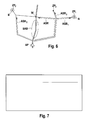
- Fig. 7 are located in the position horizon traffic disturbances on the display of the navigation device, which are listed in non-active route guidance in an additional menu item -for example, "congestion avoidance".
- the traffic disruptions are sorted either by distance or by the probability of driving.
- Fig. 8 the possible re-entry points are then shown on the display stating the street number, the connection point, the direction of travel and the travel time advantage.
- the reentry points are listed, which after selecting position 1 of the in Fig. 7 illustrated Stauliste have been calculated.
- the navigation device 1 automatically switches on a list of traffic jam messages as soon as a traffic jam is reported in the navigation system's position horizon. The user no longer has to press the corresponding congestion button.
- the determined alternative road routes ASR can also be graphically displayed.
- the user can then, e.g. Select an alternative road route via a rotary pushbutton (this will then be highlighted in color) and start the route guidance by pressing.
- each update checks whether a new reentry point can be found in the horizon. If the driver has not activated a traffic jam bypass, it can be checked whether there is a greater travel time advantage when using this point. If the driver has already activated a traffic jam bypass, the travel time advantage for the new reentry point can be determined in the background. If the travel time advantage increases, the user can be offered the new "destination" for the congestion avoidance.
Landscapes
- Engineering & Computer Science (AREA)
- Radar, Positioning & Navigation (AREA)
- Remote Sensing (AREA)
- Physics & Mathematics (AREA)
- General Physics & Mathematics (AREA)
- Automation & Control Theory (AREA)
- Mathematical Physics (AREA)
- Navigation (AREA)
Abstract
Description
Die vorliegende Erfindung geht aus von einem Navigationsgerät sowie von einem Verfahren zur Berechnung und Ausgabe mindestens einer alternativen Strassenroute im Staufall nach den Merkmalen der Oberbegriffe der Ansprüche 1 und 7.The present invention is based on a navigation device and a method for calculating and outputting at least one alternative road route in the traffic jam according to the features of the preambles of
Aus der
Aus der
Ferner sind in der
Um jedoch Staus umfahren zu können, müsste bei derartigen Systemen der Fahrer als nächstes ein Ziel eingeben, damit die Zielführungsfunktion aktiviert werden kann.However, in order to avoid traffic jams, in such systems, the driver would have to enter a destination next to enable the route guidance function.
Aufgabe der Erfindung ist es, die zuvor beschriebenen Navigationssysteme funktional zu erweitern und die Handhabung für den Fahrer weiter zu vereinfachen.The object of the invention is to functionally expand the navigation systems described above and to further simplify handling for the driver.
Die Lösung der Aufgabe erfolgt durch die im Anspruch 1 und 7 angegebenen Merkmale.The object is achieved by the features specified in
Der Grundgedanke der Erfindung liegt darin, dass dem Fahrer bzw. dem Nutzer des Navigationssystems auf vorteilhafte Art und Weise auch bei deaktivierter Zielführungsfunktion für jeden Stau, der in einem definierten Positionshorizont liegt, mindestens eine alternative Strassenroute angeboten wird.The basic idea of the invention is that the driver or the user of the navigation system is advantageously offered at least one alternative road route even if the route guidance function is deactivated for each traffic jam that lies in a defined position horizon.
Dazu wird in einem ersten Verfahrensschritt mindestens ein hinter dem Stauabschnitt liegender Wiedereintrittspunkt für die ursprüngliche Strassenroute ermittelt. Danach wird mindestens eine alternative Strassenroute ermittelt, die nicht vom Stau betroffen ist und die zum Wiedereintrittspunkt der ursprünglichen Strassenroute führt. Als dritter Schritt erfolgt die Markierung der ermittelten alternativen Strassenroute als "Ziel" für die Umfahrung des Stauabschnitts.For this purpose, in a first method step, at least one reentry point for the original road route lying behind the congestion section is determined. Afterwards, at least one alternative road route will be identified, which is not affected by the traffic jam and which leads to the reentry point of the original road route. As a third step, the marking of the determined alternative road route takes place as a "destination" for the avoidance of the traffic jam section.
Für den Fall, dass durch das Navigationssystem mehrere Wiedereintrittspunkte ermittelt worden sind, wird zusätzlich zu den drei zuvor beschriebenen Verfahrensschritten noch der Fahrzeitvorteil der ermittelten alternativen Strassenrouten berechnet und die alternative Strassenroute mit dem größten Fahrzeitvorteil als "Ziel" für die Umfahrung des Stauabschnitts ausgegeben.In the event that several reentry points have been determined by the navigation system, in addition to the three method steps described above, the travel time advantage of the determined alternative road routes calculated and issued the alternative road route with the greatest travel time advantage as "destination" for bypassing the congestion section.
In den Unteransprüchen sind weitere vorteilhafte Ausgestaltungen und Verbesserungen des erfindungsgemäßen Navigationsgeräts bzw. des erfindungsgemäßen Verfahrens zur Berechnung und Ausgabe von alternativen Strassenrouten bei Verkehrsstörungswarnungen enthalten.In the dependent claims, further advantageous refinements and improvements of the navigation device according to the invention and of the method according to the invention for calculating and outputting alternative road routes are included in traffic disruption warnings.
Es wird vorgeschlagen, dass Verkehrsstörungen, die im Positionshorizont liegen, in der auf dem Display des Navigationsgeräts ausgegebenen Liste ganz oben stehen.It is proposed that traffic disruptions that lie in the position horizon are at the top of the list output on the display of the navigation device.
Zur Verbesserung bzw. Vereinfachung der Darstellung auf dem Bedienerdisplay ist dazu auf vorteilhafte Art und Weise ein zusätzlicher Menüpunkt, z.B. "Stauumfahrung", vorgesehen. Dabei sind die Stauabschnitte entweder nach der Entfernung -die direkt vor dem Fahrer liegenden Stauabschnitte zuerst- oder nach der Wahrscheinlichkeit des Befahrens sortiert.To improve or simplify the presentation on the operator's display is an advantageous way to do so additional menu item, eg "traffic jam bypass" provided. In this case, the traffic jam sections are sorted either after the distance - the traffic jam sections lying directly in front of the driver first - or according to the probability of driving.
Zum ausgewählten Stau werden auf vorteilhafte Weise die möglichen Wiedereintrittspunkte, vorzugsweise unter Angabe von Strassennummer, Anschlussstelle, Fahrtrichtung und Fahrzeitvorteil präsentiert.For the selected congestion, the possible reentry points, preferably stating the road number, connection point, direction of travel and travel time advantage, are presented in an advantageous manner.
Es ist auch denkbar, dass das Navigationssystem automatisch eine Liste der betroffenen Staus ausgibt, sobald ein Stau im Positionshorizont des Navigationssystems gemeldet wird. Der Nutzer braucht dann nicht mehr die entsprechende Stautaste drücken. Ist nur ein Stau vorhanden, so ist eine Auswahl des Staus nicht notwendig und es kann direkt zur Auswahl des Wiedereintrittspunktes gewechselt werden.It is also conceivable that the navigation system automatically outputs a list of the affected traffic jams as soon as a traffic jam is reported in the navigation system's position horizon. The user then no longer needs to press the appropriate mouse button. If there is only a traffic jam, it is not necessary to select the jam and it is possible to change directly to the selection of the reentry point.
Bei Navigationsgeräten mit Kartendarstellung sind die alternativen Strassenrouten auf dem Display dargestellt und können z.B. mit Hilfe eines Dreh- und Drückgebers ausgewählt und gestartet werden.In navigation devices with map display, the alternative road routes are shown on the display and may be e.g. can be selected and started with the aid of a rotary and push-button encoder.
Das Verfahren zur Ermittlung von alternativen Strassenrouten im Staufall kann auf vorteilhafte Art und Weise dadurch erweitert werden, dass sich bei Stauabschnitten, die sich über Abzweigungen bzw. Kreuzungen erstrecken, auch für die von den Abzweigungen bzw. Kreuzungen wegführenden Strassenabschnitte alternative Wiedereintrittspunkte berechnet werden.The method for determining alternative road routes in the traffic jam can advantageously be extended by calculating alternative reentry points for traffic jam sections which extend over branches or intersections, also for the road sections leading away from the junctions or intersections.
Dem Fahrer können weiterhin ausserhalb des Stauabschnitts liegende markante Zielpunkte, wie z.B. Zentrum Stadt A, oder als im Speicher des Navigationsgeräts abgelegte Ziele angeboten werden.The driver may further have prominent target points outside the jam section, such as e.g. Center City A, or offered as stored in the memory of the navigation device targets.
Ausführungsbeispiele der Erfindung sind in der nachfolgenden Beschreibung und Zeichnung näher erläutert.Embodiments of the invention are explained in more detail in the following description and drawings.
Es zeigen:
-
Figur 1 -
Figur 2 -
Figur 3 -
Figur 4 eine schematische grafische Darstellung zur Ermittlung des günstigsten Wieder-Eintrittspunktes für eine Stauumfahrung, -
Figur 5 -
Figur 6 -
Figur 7 eine Displayanzeige auf dem Bildschirm eines Navigationsgeräts im Fall von Verkehrsstörungsmeldungen und -
Figur 8 eine Displayanzeige auf dem Bildschirm eines Navigationsgeräts im Fall einer ausgewählten Verkehrsstörungsmeldung.
-
FIG. 1 a schematic representation of a navigation device for motor vehicles with its essential components, -
FIG. 2 a schematic graphical representation of valid reentry points for an alternative road route in a traffic jam, -
FIG. 3 a schematic diagram for alternative road routes in traffic jams, -
FIG. 4 a schematic diagram for determining the cheapest re-entry point for a traffic jam bypass, -
FIG. 5 a schematic graphical representation of possible reentry points, if there are any distractions to other roads, -
FIG. 6 a schematic graphical representation of possible reentry points, which are selected based on distinctive target points or stored in the memory of the navigation device, -
FIG. 7 a display on the screen of a navigation device in the event of traffic jam messages and -
FIG. 8 a display on the screen of a navigation device in the event of a selected traffic jam message.
In
Die Fahrtroutenermittlungseinrichtung 3 arbeitet auf bekannte Art und Weise mit einem digitalisierten Netz in Form von Knoten und Kanten, denen sich Verkehrslageinformationen mit Hilfe einer Verkehrslagen- Auswertungseinheit 4 zuordnen lassen.The
Die Verkehrslageinformationen können beispielsweise über den Traffic-Message-Channel TMC ausgewertet werden, über den Verkehrslagemeldungen von Radiosendern (Radio Data-System, kurz RDS) ausgestrahlt werden. Diese Verkehrslageinformationen werden in der Verkehrslagen- Auswertungseinheit 4 beispielsweise über Referenzlisten Strassenabschnitte und/oder Strassenknotenpunkte zugeordnet, die dann im Navigationsgerät 1 entsprechend gekennzeichnet werden.The traffic situation information can, for example, be evaluated via the traffic message channel TMC, via which traffic situation reports from radio stations (Radio Data System, RDS for short) are broadcast. This traffic situation information is assigned in the traffic situation evaluation unit 4, for example, via reference lists road sections and / or road junctions, which are then marked accordingly in the
Das Navigationsgerät 1 hat weiterhin eine Steuereinheit 5, in denen die optimierten Routen- und Verkehrslageinformationen zusammengeführt und optisch über ein Display 6 und/oder über ein Lautsprechersystem 7 ausgegeben werden.The
Im deaktivierten Zustand der Fahrtroutenermittlungseinrichtung 3 erfolgt durch die Verkehrslagen-Auswertungseinheit 4 und die Steuereinheit 5 eine Überprüfung der von der aktuellen Ortsposition des Kraftfahrzeuges aus in Fahrtrichtung vor dem Kraftfahrzeug liegenden Verkehrswege auf vorhandene Verkehrslageinformationen. Es erfolgt nicht nur eine Ausgabe von Warnmeldungen, sondern auch die Berechnung und Ausgabe mindestens einer alternativen Strassenroute ASR. Diese Funktion wird nachfolgend anhand der
Nachdem von der Verkehrslagen- Auswertungseinheit 4 ein Stauabschnitt SAB erfasst worden ist und, um einen Wiedereintrittspunkt W zu ermitteln, bei dem der Fahrer wieder auf die ursprüngliche Strasse geführt werden kann, wird der Positionshorizont entsprechend durchsucht. Der Positionshorizont ist ein Graph, bei dem die Straßen ermittelt werden, welche man ausgehend von der aktuellen Position erreichen kann. Zusätzlich sollte der Positionshorizont für diese Funktion für jeden Straßenabschnitt im Graphen die Informationen enthalten, von welchen Strassen dieser Abschnitt noch erreicht werden kann. Wie in
Dabei werden potenzielle Wiedereintrittspunkte -in
Es kann auch sinnvoll sein, mehrere Wiedereintrittspunkte für die Umfahrung des Stauabschnitts SAB zu ermitteln. In
In
Für den Fall, dass im Stauabschnitt SAB Abzweigungen AB oder Kreuzungen KR vorhanden sind, so ist -wie in
Es ist auch denkbar, dass der Fahrer die direkt hinter dem Stauabschnitt SAB liegende Abzweigung AB abfahren wollte, um z.B. die an dieser Anschlussstelle liegende Stadt zu erreichen. Die Umfahrung über die alternative Strassenroute ASR zum Wiedereintrittspunkt W ist -wie in
Um dem Fahrer trotzdem sinnvolle "Ziele" für die Stauumfahrung anbieten zu können, ist vorgesehen, dass ausserhalb des Stauabschnitts SAB liegende besondere Zielpunkte ZP1 und ZP2 (Stadt A, B) oder in der Nähe vom Wiedereintrittspunkt W im Speicher ablegte Zielpunkte ZP3 ermittelt und angezeigt werden, zu denen dann entsprechende alternative Strassenrouten ASR1, ASR2 und ASR3 berechnet werden. Es ist auch denkbar, dass dem Fahrer weiter entfernt liegende Zielspeichereinträge vorgeschlagen werden, wenn diese in der Vergangenheit häufig verwendet wurden oder dass der Fahrer bestimmte Ziele festlegen kann (z.B. "zu Hause"), welche bei einer Stauumfahrung immer angeboten werden sollten.In order to offer the driver still meaningful "targets" for the avoidance of traffic jams, it is envisaged that lies outside the impact section SAB specific target points ZP 1 and ZP 2 (city A, B) or near the re-entry point W in the store took off target points ZP 3 determined and displayed, to which corresponding alternative road routes ASR 1 , ASR 2 and ASR 3 are calculated. It is also conceivable that the driver further away destination memory entries are proposed, if they were used frequently in the past or that the driver can set certain goals (eg "at home"), which should always be offered in a traffic jam avoidance.
In
In
Es ist auch denkbar, dass das Navigationsgerät 1 automatisch eine Liste der Staumeldungen aufschaltet, sobald ein Stau im Positionshorizont des Navigationssystems gemeldet wird. Der Nutzer muss dann nicht mehr die entsprechende Stau- Taste drücken.It is also conceivable that the
Bei Navigationsgeräten mit Kartendarstellung können die ermittelten alternativen Strassenrouten ASR (und die betroffenen Staus) auch grafisch dargestellt werden. Der Nutzer kann dann z.B. über einen Dreh- Drückgeber eine alternative Strassenroute auswählen (diese wird dann farblich hervorgehoben) und durch Drücken die Zielführung starten.In the case of navigation devices with map display, the determined alternative road routes ASR (and the congestions concerned) can also be graphically displayed. The user can then, e.g. Select an alternative road route via a rotary pushbutton (this will then be highlighted in color) and start the route guidance by pressing.
Da der Positionshorizont mit jeder neuen Fahrzeugposition weiter ausgebaut werden kann, ist es auch denkbar, dass mit jedem update überprüft wird, ob eine neuer Wiedereintrittspunkt im Horizont auffindbar ist. Hat der Fahrer noch keine Stauumfahrung aktiviert, kann überprüft werden, ob sich ein grösserer Fahrzeitvorteil bei Verwendung dieses Punktes ergibt. Falls der Fahrer bereits eine Stauumfahrung aktiviert hat, kann im Hintergrund der Fahrzeitvorteil für den neuen Wiedereintrittspunkt ermittelt werden. Erhöht sich der Fahrzeitvorteil, kann dem Nutzer das neue "Ziel" für die Stauumfahrung vorgeschlagen werden.Since the position horizon can be further expanded with each new vehicle position, it is also conceivable that each update checks whether a new reentry point can be found in the horizon. If the driver has not activated a traffic jam bypass, it can be checked whether there is a greater travel time advantage when using this point. If the driver has already activated a traffic jam bypass, the travel time advantage for the new reentry point can be determined in the background. If the travel time advantage increases, the user can be offered the new "destination" for the congestion avoidance.
Claims (9)
- Navigation appliance (1) for motor vehicles having a position-finding device (2) for determining the current local position of the motor vehicle and having a central or distributed traffic situation evaluation unit (4) for receiving and evaluating traffic situation information and also having a journey route ascertainment device (3) with dynamic routing which involves automatic calculation of at least one alternative road route (ASR) in the event of a queue, wherein when the routing function is deactivated, at least one alternative road route (ASR) is calculated and output in the event of traffic disruption warnings, characterized in that the journey route ascertainment device (3) proposes an alternative road route (ASR) on the basis of destination memory entries (ZP1, ZP2, ZP3), wherein the destination memory entries comprise at least one of the following properties:
the destination is a- point of interest (ZP2), such as a town or town centre, which is situated outside the queue section (SAB) and a possible re-entry point (W),- destination (ZP3) which is situated in proximity to a possible re-entry point (W) and which is not the same as the re-entry point (W),- destination which can be stipulated by the driver, so that said destination is always offered when circumnavigating queues, and/or- destination frequently used in the past from a destination memory. - Navigation appliance (1) according to Claim 1, characterized in that the traffic disruptions on the position horizon, which is a graph in which roads are ascertained which can be reached from the current position, are at the very top in the list which is output on a display (6) of the navigation appliance (1).
- Navigation appliance (1) according to Claim 2, characterized in that an additional menu item, e.g. "Queue circumnavigation", is provided which presents the queue sections (SAB) which are situated on the position horizon.
- Navigation appliance (1) according to Claim 3, characterized in that the queue sections (SAB) are sorted either on the basis of distance, with the queue sections (SAB) situated directly ahead being displayed first, or on the basis of probability of use.
- Navigation appliance (1) according to one of Claims 2 to 4, characterized in that the display (6) of the navigation appliance (1) presents the possible re-entry points for the selected queue, preferably with an indication of road number, junction, direction of travel and travelling time advantage.
- Navigation appliance (1) according to Claim 5, characterized in that the alternative road routes (ASR) are presented on the display (6) of the navigation appliance (1) and can preferably be selected and started using a rotary/push transmitter.
- Method for calculating and outputting an alternative road route (ASR) in the event of traffic disruption warnings using a navigation appliance (1) according to the features of one of the preceding claims, characterized by the following checking algorithm:- a re-entry point (W) after the queue section (SAB) is ascertained,- alternative road routes (ASR) which are not affected by the queue and which lead to the re-entry point (W) are ascertained on the basis of destination memory entries (ZP1, ZP2, ZP3) which comprise at least one of the following properties:
the destination is a- point of interest (ZP2), such as a town or town centre, which is situated outside the queue section (SAB) and a possible re-entry point (W),- destination (ZP3) which is situated in proximity to a possible re-entry point (W) and which is not the same as the re-entry point (W),- destination which can be stipulated by the driver, so that said destination is always offered when circumnavigating queues, and/or- destination frequently used in the past from a destination memory, and- at least one ascertained alternative road route (ASR) is marked as the "destination" for the circumnavigation of the queue section (SAB). - Method according to Claim 7, characterized by the following steps:- the travelling time advantage of the ascertained alternative road routes (ASR) is calculated and- that alternative road route (ASR) which has the greatest travelling time advantage is marked as the "destination" for the circumnavigation of the queue section (SAB).
- Method according to Claim 7 or 8, characterized in that in the event of queue sections (SAB) which extend via branch-off points (AB) or junctions (KR), alternative re-entry points are also ascertained for the road sections which lead away from the branch-off points (AB) or junctions (KR).
Applications Claiming Priority (2)
| Application Number | Priority Date | Filing Date | Title |
|---|---|---|---|
| DE102007043533A DE102007043533A1 (en) | 2007-09-12 | 2007-09-12 | Navigation device for motor vehicles and method for calculating and outputting at least one alternative road route in traffic jams |
| PCT/EP2008/059552 WO2009033864A1 (en) | 2007-09-12 | 2008-07-22 | Navigation appliance for motor vehicles, and method for calculating and outputting at least one alternative road route in a tailback situation |
Publications (2)
| Publication Number | Publication Date |
|---|---|
| EP2201552A1 EP2201552A1 (en) | 2010-06-30 |
| EP2201552B1 true EP2201552B1 (en) | 2011-02-02 |
Family
ID=39830177
Family Applications (1)
| Application Number | Title | Priority Date | Filing Date |
|---|---|---|---|
| EP08786288A Active EP2201552B1 (en) | 2007-09-12 | 2008-07-22 | Navigation appliance for motor vehicles, and method for calculating and outputting at least one alternative road route in a tailback situation |
Country Status (4)
| Country | Link |
|---|---|
| EP (1) | EP2201552B1 (en) |
| AT (1) | ATE497622T1 (en) |
| DE (2) | DE102007043533A1 (en) |
| WO (1) | WO2009033864A1 (en) |
Cited By (1)
| Publication number | Priority date | Publication date | Assignee | Title |
|---|---|---|---|---|
| DE102015211910A1 (en) | 2015-06-26 | 2016-12-29 | Ford Global Technologies, Llc | Method and arrangement for route guidance of vehicles in traffic |
Families Citing this family (5)
| Publication number | Priority date | Publication date | Assignee | Title |
|---|---|---|---|---|
| DE102011078946A1 (en) | 2011-07-11 | 2013-01-17 | Robert Bosch Gmbh | Method for determining most probable path of car by software modules, involves providing personal and impersonal driving probability data for correcting original path, where data is derived from previous driving behavior of vehicle |
| US9396654B2 (en) | 2012-07-17 | 2016-07-19 | Mitsubishi Electric Corporation | In-vehicle traffic information notification device |
| DE102013200393A1 (en) | 2013-01-14 | 2014-07-17 | Robert Bosch Gmbh | Method and device for providing navigation targets for a motor vehicle |
| DE102014213287A1 (en) * | 2014-07-09 | 2016-01-14 | Bayerische Motoren Werke Aktiengesellschaft | navigation methods |
| DE102018209804A1 (en) | 2018-06-18 | 2019-12-19 | Robert Bosch Gmbh | Method and device for predicting a likely driving route for a vehicle |
Family Cites Families (4)
| Publication number | Priority date | Publication date | Assignee | Title |
|---|---|---|---|---|
| DE10233376A1 (en) | 2002-07-23 | 2004-02-12 | Fendt, Günter | Intelligent predictive driver assistance system and/or traffic warning system has ability to predict route to be driven or to attempt to predict route when no route data have been entered |
| DE10253135B4 (en) | 2002-11-14 | 2012-04-26 | Volkswagen Ag | Method and device for preparing traffic information |
| DE10327188B4 (en) | 2003-06-17 | 2020-06-18 | Robert Bosch Gmbh | Navigation device for motor vehicles and method for outputting traffic situation information with such a navigation device |
| DE10354218A1 (en) | 2003-11-20 | 2005-06-30 | Siemens Ag | Method for selecting and preparing traffic information |
-
2007
- 2007-09-12 DE DE102007043533A patent/DE102007043533A1/en not_active Withdrawn
-
2008
- 2008-07-22 EP EP08786288A patent/EP2201552B1/en active Active
- 2008-07-22 DE DE502008002537T patent/DE502008002537D1/en active Active
- 2008-07-22 AT AT08786288T patent/ATE497622T1/en active
- 2008-07-22 WO PCT/EP2008/059552 patent/WO2009033864A1/en not_active Ceased
Cited By (1)
| Publication number | Priority date | Publication date | Assignee | Title |
|---|---|---|---|---|
| DE102015211910A1 (en) | 2015-06-26 | 2016-12-29 | Ford Global Technologies, Llc | Method and arrangement for route guidance of vehicles in traffic |
Also Published As
| Publication number | Publication date |
|---|---|
| WO2009033864A1 (en) | 2009-03-19 |
| DE102007043533A1 (en) | 2009-03-19 |
| ATE497622T1 (en) | 2011-02-15 |
| DE502008002537D1 (en) | 2011-03-17 |
| EP2201552A1 (en) | 2010-06-30 |
Similar Documents
| Publication | Publication Date | Title |
|---|---|---|
| EP1307707B1 (en) | Route calculation method | |
| DE4301875C2 (en) | Traffic navigation device with a secondary route function | |
| DE69931683T2 (en) | Car navigation device | |
| EP2201552B1 (en) | Navigation appliance for motor vehicles, and method for calculating and outputting at least one alternative road route in a tailback situation | |
| EP1147375A1 (en) | Method for leading the user of a vehicle from at least one starting point to at least one point of destination | |
| EP2005115B1 (en) | Navigation arrangement and method for a motor vehicle | |
| EP1062481B1 (en) | Method for issuing traffic information | |
| EP1102227B1 (en) | Method for dynamic guidance of a vehicle | |
| EP0944894B1 (en) | Computer-controlled navigation process for a vehicle equipped with a terminal, terminal and traffic information centre | |
| EP1533592B1 (en) | Method for selecting and processing traffic information | |
| EP1271104B1 (en) | Vehicle navigation method | |
| DE102016000970A1 (en) | Method for operating a detection device of a motor vehicle | |
| DE10218340A1 (en) | Navigation system and method for determining the route | |
| EP2131152B1 (en) | Navigation system and method for operating the same | |
| DE102007057989B4 (en) | Device for navigation | |
| DE102015200081A1 (en) | Providing navigation instructions in a vehicle | |
| EP2205942B1 (en) | Navigation system and method for route planning | |
| DE10327188B4 (en) | Navigation device for motor vehicles and method for outputting traffic situation information with such a navigation device | |
| DE102006004616A1 (en) | Method and device for determining a detour route in a motor vehicle with a non-activated navigation system | |
| EP1412702B1 (en) | Navigation device | |
| DE10311516A1 (en) | Method for calculating the route in a navigation system | |
| EP0849563B1 (en) | System for weighted optimisation of itineraries | |
| DE102005060098A1 (en) | navigation system | |
| EP1260793B1 (en) | Method for route planning with a navigation system | |
| DE102010028093A1 (en) | Method for assigning characteristic to road section of road map of navigation system, involves displaying section of road map on display element of navigation system |
Legal Events
| Date | Code | Title | Description |
|---|---|---|---|
| PUAI | Public reference made under article 153(3) epc to a published international application that has entered the european phase |
Free format text: ORIGINAL CODE: 0009012 |
|
| 17P | Request for examination filed |
Effective date: 20100412 |
|
| AK | Designated contracting states |
Kind code of ref document: A1 Designated state(s): AT BE BG CH CY CZ DE DK EE ES FI FR GB GR HR HU IE IS IT LI LT LU LV MC MT NL NO PL PT RO SE SI SK TR |
|
| AX | Request for extension of the european patent |
Extension state: AL BA MK RS |
|
| GRAP | Despatch of communication of intention to grant a patent |
Free format text: ORIGINAL CODE: EPIDOSNIGR1 |
|
| DAX | Request for extension of the european patent (deleted) | ||
| GRAS | Grant fee paid |
Free format text: ORIGINAL CODE: EPIDOSNIGR3 |
|
| GRAA | (expected) grant |
Free format text: ORIGINAL CODE: 0009210 |
|
| AK | Designated contracting states |
Kind code of ref document: B1 Designated state(s): AT BE BG CH CY CZ DE DK EE ES FI FR GB GR HR HU IE IS IT LI LT LU LV MC MT NL NO PL PT RO SE SI SK TR |
|
| REG | Reference to a national code |
Ref country code: GB Ref legal event code: FG4D Free format text: NOT ENGLISH |
|
| REG | Reference to a national code |
Ref country code: CH Ref legal event code: EP |
|
| REG | Reference to a national code |
Ref country code: IE Ref legal event code: FG4D Free format text: LANGUAGE OF EP DOCUMENT: GERMAN |
|
| REF | Corresponds to: |
Ref document number: 502008002537 Country of ref document: DE Date of ref document: 20110317 Kind code of ref document: P |
|
| REG | Reference to a national code |
Ref country code: DE Ref legal event code: R096 Ref document number: 502008002537 Country of ref document: DE Effective date: 20110317 |
|
| REG | Reference to a national code |
Ref country code: SE Ref legal event code: TRGR |
|
| REG | Reference to a national code |
Ref country code: NL Ref legal event code: VDEP Effective date: 20110202 |
|
| LTIE | Lt: invalidation of european patent or patent extension |
Effective date: 20110202 |
|
| PG25 | Lapsed in a contracting state [announced via postgrant information from national office to epo] |
Ref country code: HR Free format text: LAPSE BECAUSE OF FAILURE TO SUBMIT A TRANSLATION OF THE DESCRIPTION OR TO PAY THE FEE WITHIN THE PRESCRIBED TIME-LIMIT Effective date: 20110202 Ref country code: LV Free format text: LAPSE BECAUSE OF FAILURE TO SUBMIT A TRANSLATION OF THE DESCRIPTION OR TO PAY THE FEE WITHIN THE PRESCRIBED TIME-LIMIT Effective date: 20110202 Ref country code: NO Free format text: LAPSE BECAUSE OF FAILURE TO SUBMIT A TRANSLATION OF THE DESCRIPTION OR TO PAY THE FEE WITHIN THE PRESCRIBED TIME-LIMIT Effective date: 20110502 Ref country code: PT Free format text: LAPSE BECAUSE OF FAILURE TO SUBMIT A TRANSLATION OF THE DESCRIPTION OR TO PAY THE FEE WITHIN THE PRESCRIBED TIME-LIMIT Effective date: 20110602 Ref country code: ES Free format text: LAPSE BECAUSE OF FAILURE TO SUBMIT A TRANSLATION OF THE DESCRIPTION OR TO PAY THE FEE WITHIN THE PRESCRIBED TIME-LIMIT Effective date: 20110513 Ref country code: GR Free format text: LAPSE BECAUSE OF FAILURE TO SUBMIT A TRANSLATION OF THE DESCRIPTION OR TO PAY THE FEE WITHIN THE PRESCRIBED TIME-LIMIT Effective date: 20110503 Ref country code: IS Free format text: LAPSE BECAUSE OF FAILURE TO SUBMIT A TRANSLATION OF THE DESCRIPTION OR TO PAY THE FEE WITHIN THE PRESCRIBED TIME-LIMIT Effective date: 20110602 Ref country code: LT Free format text: LAPSE BECAUSE OF FAILURE TO SUBMIT A TRANSLATION OF THE DESCRIPTION OR TO PAY THE FEE WITHIN THE PRESCRIBED TIME-LIMIT Effective date: 20110202 |
|
| PG25 | Lapsed in a contracting state [announced via postgrant information from national office to epo] |
Ref country code: BG Free format text: LAPSE BECAUSE OF FAILURE TO SUBMIT A TRANSLATION OF THE DESCRIPTION OR TO PAY THE FEE WITHIN THE PRESCRIBED TIME-LIMIT Effective date: 20110502 Ref country code: CY Free format text: LAPSE BECAUSE OF FAILURE TO SUBMIT A TRANSLATION OF THE DESCRIPTION OR TO PAY THE FEE WITHIN THE PRESCRIBED TIME-LIMIT Effective date: 20110202 Ref country code: PL Free format text: LAPSE BECAUSE OF FAILURE TO SUBMIT A TRANSLATION OF THE DESCRIPTION OR TO PAY THE FEE WITHIN THE PRESCRIBED TIME-LIMIT Effective date: 20110202 Ref country code: FI Free format text: LAPSE BECAUSE OF FAILURE TO SUBMIT A TRANSLATION OF THE DESCRIPTION OR TO PAY THE FEE WITHIN THE PRESCRIBED TIME-LIMIT Effective date: 20110202 Ref country code: NL Free format text: LAPSE BECAUSE OF FAILURE TO SUBMIT A TRANSLATION OF THE DESCRIPTION OR TO PAY THE FEE WITHIN THE PRESCRIBED TIME-LIMIT Effective date: 20110202 Ref country code: SI Free format text: LAPSE BECAUSE OF FAILURE TO SUBMIT A TRANSLATION OF THE DESCRIPTION OR TO PAY THE FEE WITHIN THE PRESCRIBED TIME-LIMIT Effective date: 20110202 |
|
| REG | Reference to a national code |
Ref country code: IE Ref legal event code: FD4D |
|
| PG25 | Lapsed in a contracting state [announced via postgrant information from national office to epo] |
Ref country code: EE Free format text: LAPSE BECAUSE OF FAILURE TO SUBMIT A TRANSLATION OF THE DESCRIPTION OR TO PAY THE FEE WITHIN THE PRESCRIBED TIME-LIMIT Effective date: 20110202 Ref country code: IE Free format text: LAPSE BECAUSE OF FAILURE TO SUBMIT A TRANSLATION OF THE DESCRIPTION OR TO PAY THE FEE WITHIN THE PRESCRIBED TIME-LIMIT Effective date: 20110202 Ref country code: DK Free format text: LAPSE BECAUSE OF FAILURE TO SUBMIT A TRANSLATION OF THE DESCRIPTION OR TO PAY THE FEE WITHIN THE PRESCRIBED TIME-LIMIT Effective date: 20110202 |
|
| PG25 | Lapsed in a contracting state [announced via postgrant information from national office to epo] |
Ref country code: SK Free format text: LAPSE BECAUSE OF FAILURE TO SUBMIT A TRANSLATION OF THE DESCRIPTION OR TO PAY THE FEE WITHIN THE PRESCRIBED TIME-LIMIT Effective date: 20110202 Ref country code: CZ Free format text: LAPSE BECAUSE OF FAILURE TO SUBMIT A TRANSLATION OF THE DESCRIPTION OR TO PAY THE FEE WITHIN THE PRESCRIBED TIME-LIMIT Effective date: 20110202 Ref country code: RO Free format text: LAPSE BECAUSE OF FAILURE TO SUBMIT A TRANSLATION OF THE DESCRIPTION OR TO PAY THE FEE WITHIN THE PRESCRIBED TIME-LIMIT Effective date: 20110202 |
|
| PLBE | No opposition filed within time limit |
Free format text: ORIGINAL CODE: 0009261 |
|
| STAA | Information on the status of an ep patent application or granted ep patent |
Free format text: STATUS: NO OPPOSITION FILED WITHIN TIME LIMIT |
|
| PG25 | Lapsed in a contracting state [announced via postgrant information from national office to epo] |
Ref country code: MT Free format text: LAPSE BECAUSE OF FAILURE TO SUBMIT A TRANSLATION OF THE DESCRIPTION OR TO PAY THE FEE WITHIN THE PRESCRIBED TIME-LIMIT Effective date: 20110202 |
|
| 26N | No opposition filed |
Effective date: 20111103 |
|
| BERE | Be: lapsed |
Owner name: ROBERT BOSCH G.M.B.H. Effective date: 20110731 |
|
| PG25 | Lapsed in a contracting state [announced via postgrant information from national office to epo] |
Ref country code: MC Free format text: LAPSE BECAUSE OF NON-PAYMENT OF DUE FEES Effective date: 20110731 |
|
| REG | Reference to a national code |
Ref country code: DE Ref legal event code: R097 Ref document number: 502008002537 Country of ref document: DE Effective date: 20111103 |
|
| PG25 | Lapsed in a contracting state [announced via postgrant information from national office to epo] |
Ref country code: BE Free format text: LAPSE BECAUSE OF NON-PAYMENT OF DUE FEES Effective date: 20110731 |
|
| REG | Reference to a national code |
Ref country code: CH Ref legal event code: PL |
|
| PG25 | Lapsed in a contracting state [announced via postgrant information from national office to epo] |
Ref country code: LI Free format text: LAPSE BECAUSE OF NON-PAYMENT OF DUE FEES Effective date: 20120731 Ref country code: CH Free format text: LAPSE BECAUSE OF NON-PAYMENT OF DUE FEES Effective date: 20120731 |
|
| PG25 | Lapsed in a contracting state [announced via postgrant information from national office to epo] |
Ref country code: LU Free format text: LAPSE BECAUSE OF NON-PAYMENT OF DUE FEES Effective date: 20110722 |
|
| PG25 | Lapsed in a contracting state [announced via postgrant information from national office to epo] |
Ref country code: TR Free format text: LAPSE BECAUSE OF FAILURE TO SUBMIT A TRANSLATION OF THE DESCRIPTION OR TO PAY THE FEE WITHIN THE PRESCRIBED TIME-LIMIT Effective date: 20110202 |
|
| PG25 | Lapsed in a contracting state [announced via postgrant information from national office to epo] |
Ref country code: HU Free format text: LAPSE BECAUSE OF FAILURE TO SUBMIT A TRANSLATION OF THE DESCRIPTION OR TO PAY THE FEE WITHIN THE PRESCRIBED TIME-LIMIT Effective date: 20110202 |
|
| PGFP | Annual fee paid to national office [announced via postgrant information from national office to epo] |
Ref country code: SE Payment date: 20130723 Year of fee payment: 6 |
|
| REG | Reference to a national code |
Ref country code: AT Ref legal event code: MM01 Ref document number: 497622 Country of ref document: AT Kind code of ref document: T Effective date: 20130722 |
|
| PG25 | Lapsed in a contracting state [announced via postgrant information from national office to epo] |
Ref country code: AT Free format text: LAPSE BECAUSE OF NON-PAYMENT OF DUE FEES Effective date: 20130722 |
|
| REG | Reference to a national code |
Ref country code: SE Ref legal event code: EUG |
|
| PG25 | Lapsed in a contracting state [announced via postgrant information from national office to epo] |
Ref country code: SE Free format text: LAPSE BECAUSE OF NON-PAYMENT OF DUE FEES Effective date: 20140723 |
|
| REG | Reference to a national code |
Ref country code: FR Ref legal event code: PLFP Year of fee payment: 9 |
|
| REG | Reference to a national code |
Ref country code: FR Ref legal event code: PLFP Year of fee payment: 10 |
|
| REG | Reference to a national code |
Ref country code: FR Ref legal event code: PLFP Year of fee payment: 11 |
|
| PGFP | Annual fee paid to national office [announced via postgrant information from national office to epo] |
Ref country code: FR Payment date: 20190724 Year of fee payment: 12 Ref country code: IT Payment date: 20190723 Year of fee payment: 12 |
|
| REG | Reference to a national code |
Ref country code: DE Ref legal event code: R084 Ref document number: 502008002537 Country of ref document: DE |
|
| PG25 | Lapsed in a contracting state [announced via postgrant information from national office to epo] |
Ref country code: FR Free format text: LAPSE BECAUSE OF NON-PAYMENT OF DUE FEES Effective date: 20200731 |
|
| PG25 | Lapsed in a contracting state [announced via postgrant information from national office to epo] |
Ref country code: IT Free format text: LAPSE BECAUSE OF NON-PAYMENT OF DUE FEES Effective date: 20200722 |
|
| PGFP | Annual fee paid to national office [announced via postgrant information from national office to epo] |
Ref country code: GB Payment date: 20230724 Year of fee payment: 16 |
|
| GBPC | Gb: european patent ceased through non-payment of renewal fee |
Effective date: 20240722 |
|
| PG25 | Lapsed in a contracting state [announced via postgrant information from national office to epo] |
Ref country code: GB Free format text: LAPSE BECAUSE OF NON-PAYMENT OF DUE FEES Effective date: 20240722 |
|
| PGFP | Annual fee paid to national office [announced via postgrant information from national office to epo] |
Ref country code: DE Payment date: 20250924 Year of fee payment: 18 |