EP2111069A1 - Device and method for optimising the operation of a cellular communication network by assisted definition of localisation areas - Google Patents
Device and method for optimising the operation of a cellular communication network by assisted definition of localisation areas Download PDFInfo
- Publication number
- EP2111069A1 EP2111069A1 EP08156373A EP08156373A EP2111069A1 EP 2111069 A1 EP2111069 A1 EP 2111069A1 EP 08156373 A EP08156373 A EP 08156373A EP 08156373 A EP08156373 A EP 08156373A EP 2111069 A1 EP2111069 A1 EP 2111069A1
- Authority
- EP
- European Patent Office
- Prior art keywords
- criteria
- geographical
- cartographic
- geographical area
- location
- Prior art date
- Legal status (The legal status is an assumption and is not a legal conclusion. Google has not performed a legal analysis and makes no representation as to the accuracy of the status listed.)
- Granted
Links
- 230000010267 cellular communication Effects 0.000 title claims abstract description 15
- 238000000034 method Methods 0.000 title claims abstract description 13
- 230000004807 localization Effects 0.000 title claims description 36
- 238000012545 processing Methods 0.000 claims abstract description 25
- 238000004891 communication Methods 0.000 claims abstract description 14
- 238000005457 optimization Methods 0.000 claims description 24
- 238000000354 decomposition reaction Methods 0.000 claims description 15
- 238000001514 detection method Methods 0.000 claims description 2
- 230000000903 blocking effect Effects 0.000 abstract 1
- 210000004027 cell Anatomy 0.000 description 53
- 238000007726 management method Methods 0.000 description 19
- 230000001413 cellular effect Effects 0.000 description 12
- 240000008042 Zea mays Species 0.000 description 5
- 230000010354 integration Effects 0.000 description 5
- 230000011664 signaling Effects 0.000 description 2
- 239000002699 waste material Substances 0.000 description 2
- 238000012152 algorithmic method Methods 0.000 description 1
- 239000000470 constituent Substances 0.000 description 1
- 238000013479 data entry Methods 0.000 description 1
- 238000011161 development Methods 0.000 description 1
- 238000005194 fractionation Methods 0.000 description 1
- 230000006870 function Effects 0.000 description 1
- 238000005259 measurement Methods 0.000 description 1
- 238000012544 monitoring process Methods 0.000 description 1
- 230000002093 peripheral effect Effects 0.000 description 1
- 238000000638 solvent extraction Methods 0.000 description 1
- 230000002123 temporal effect Effects 0.000 description 1
Images



Classifications
-
- H—ELECTRICITY
- H04—ELECTRIC COMMUNICATION TECHNIQUE
- H04W—WIRELESS COMMUNICATION NETWORKS
- H04W99/00—Subject matter not provided for in other groups of this subclass
-
- H—ELECTRICITY
- H04—ELECTRIC COMMUNICATION TECHNIQUE
- H04W—WIRELESS COMMUNICATION NETWORKS
- H04W16/00—Network planning, e.g. coverage or traffic planning tools; Network deployment, e.g. resource partitioning or cells structures
- H04W16/18—Network planning tools
-
- H—ELECTRICITY
- H04—ELECTRIC COMMUNICATION TECHNIQUE
- H04W—WIRELESS COMMUNICATION NETWORKS
- H04W24/00—Supervisory, monitoring or testing arrangements
- H04W24/02—Arrangements for optimising operational condition
-
- H—ELECTRICITY
- H04—ELECTRIC COMMUNICATION TECHNIQUE
- H04W—WIRELESS COMMUNICATION NETWORKS
- H04W84/00—Network topologies
- H04W84/02—Hierarchically pre-organised networks, e.g. paging networks, cellular networks, WLAN [Wireless Local Area Network] or WLL [Wireless Local Loop]
- H04W84/04—Large scale networks; Deep hierarchical networks
- H04W84/042—Public Land Mobile systems, e.g. cellular systems
-
- H—ELECTRICITY
- H04—ELECTRIC COMMUNICATION TECHNIQUE
- H04W—WIRELESS COMMUNICATION NETWORKS
- H04W84/00—Network topologies
- H04W84/02—Hierarchically pre-organised networks, e.g. paging networks, cellular networks, WLAN [Wireless Local Area Network] or WLL [Wireless Local Loop]
- H04W84/10—Small scale networks; Flat hierarchical networks
- H04W84/12—WLAN [Wireless Local Area Networks]
Definitions
- the invention relates to cellular communication networks, and more particularly to optimizing the operation of such networks.
- cellular communication network is meant here any type of radio (or wireless) network comprising a radio access network whose coverage area is defined by a set of cells (or equivalent). It may therefore be, for example, a mobile or cellular telephone network (GSM, GPRS / EDGE, UMTS or CDMA2000, as well as all their variants and all their equivalents), or a wireless local area network ( WLAN (Wireless Local Area Network - IEEE 802.11, Wi-Fi, ETSI HiperLAN / 2), Bluetooth (IEEE 802.15), WiMAX (IEEE 802.16, ETSI HiperMAN) and Zigbee standards, and in general of any type network in which the concept of decomposition into location zones (or “location areas” (or LACs)) requires a setting that can be adapted.
- GSM Global System for Mobile Communications
- GPRS / EDGE Wireless Fidelity
- UMTS Code Division Multiple Access
- CDMA2000 Code Division Multiple Access 2000
- WLAN Wireless Local Area Network - IEEE 802.11, Wi
- the invention aims more particularly to assist (semi-automatically) an operator to define location areas (or "location areas" or LACs) for at least part of its cellular communication network.
- location area refers to an area defined by a group of cells whose elements that constitute them geographically at a given moment have the same location behavior in the network.
- a location area is defined by a group of cells having the same "paging" code, ie a set of cells that are simultaneously informed of an incoming call concerning one between them.
- a mobile station can therefore move freely within a given location area without having to update the network position recorder.
- RNC radio network controller
- location zones are particularly important within a cellular network. Indeed, when the location areas are very large, many mobile terminals will operate simultaneously. Therefore, this will induce a very large paging traffic, since all paging requests must be broadcast to all base stations that are part of a location area. This not only leads to wasted bandwidth, but also a waste of the energy stored in the batteries of the mobile terminals since the latter must listen to broadcast messages too much of the time. Now, when the location areas are small, the mobile terminals must contact the network much more often to report a change of location area, which also results in a waste of energy stored in their batteries.
- LACs localization zones
- the aim of the invention is therefore to provide assistance combining at least partial automation, mainly based on geographical component (localized) information, of the definition of the location areas (LACs) in at least part of a network of cellular communication with the ability to manually correct this definition.
- LACs location areas
- a device dedicated to optimizing the operation (and / or configuration) of at least a portion of a cellular communication network comprising objects of known geographical positions, and comprising processing means.
- processing means charged, in the case of selection of a geographical area covered by the network and of at least one cartographic criterion relating to objects, to constitute, within this selected geographical area and according to each selected cartographic criterion, groups of cells each defining a local area.
- object is meant here any network element or network topology (for example a base station (Node B, BS or BTS), a cell or an adjacency).
- Node B Node B, BS or BTS
- cell or an adjacency
- the invention also proposes a network management equipment equipped with an optimization device of the type of that presented above.
- the object of the invention is to allow the definition of at least partially automatic, mainly based on geographical component information (localized), defining location areas in at least part of a cellular communication network, while leaving (to the network operator) the possibility of modifying manually this definition to take into account, for example, information which it has but which are not known to the network management system.
- the cellular communication network is a cellular (or mobile) network, such as a GSM network, or GPRS / EDGE, or UMTS, or CDMA2000.
- a cellular (or mobile) network such as a GSM network, or GPRS / EDGE, or UMTS, or CDMA2000.
- the invention is not limited to this type of cellular network. It concerns any type of radio communication network, including wireless local area networks (Wireless Local Area Network (IEEE 802.11, Wi-Fi, ETSI HiperLAN / 2), Bluetooth (IEEE 802.15), WiMAX (IEEE 802.16, ETSI HiperMAN) and Zigbee).
- the invention relates to any type of network in which the concept of decomposition into areas of location (or location areas (LACs)) requires a setting that can be adapted.
- LACs location areas
- a cellular network can be schematically summarized to a switching network (or “Core Network") coupled to a radio access network (called UTRAN in the case of a UMTS and BSS network in the case of a GSM network), itself connected to a network management system or NMS (for "Network Management System”).
- UTRAN radio access network
- NMS Network Management System
- the RC network comprises network elements (or equipment).
- network element or equipment
- the term "network element (or equipment)” is understood here to mean any constituent (physical and / or logical) of a network through which traffics which may be locally defined by parameter (s) or indicator (s) values are passed. ) (eg quality of service (QoS)) that can be measured or estimated by the Network Management System (NMS).
- QoS quality of service
- NMS Network Management System
- It may be, for example, a cell in which mobile terminals can establish or continue communications, or network equipment, such as a router, a base station (Node B in the case of a UMTS and BTS network in the case of a GSM network), or a radio network controller (RNC in the case of a UMTS and BSC network in the case of a GSM network).
- Node B in the case of a UMTS and BTS network in the case of a GSM network
- RNC radio network controller
- RNCs or BSCs radio network controller
- At least some of the network elements (or equipment) mentioned above are (network) objects. This is particularly the case for base stations (Node Bs and BTSs), radio network controllers (RNCs and BSCs) and cells. It will be noted that the objects may be network elements or network topology elements such as, for example, adjacencies.
- the invention proposes to equip a cellular network RC of at least one device D responsible for optimizing the operation (and / or configuration) of at least one of its parts implanted in a known geographical area.
- an optimization device D can be part of an EG management equipment (such as a computer or a workstation) responsible for at least partially managing the operation and / or planning and / or configuration of the network.
- an EG management equipment such as a computer or a workstation
- this management equipment EG may itself be part of the NMS network management system.
- the optimization device D may constitute on its own an EG management equipment that may possibly be part of (or be coupled to) the NMS network management system.
- an optimization device D can be part of a network optimization tool (for example of the RNO® or NPO® type).
- An optimization device D comprises at least one an MT processing module responsible for intervening whenever a geographical area (covered by the RC network) and at least one cartographic criterion (having at least one relation with objects of the cellular network RC) have been selected, in order to constitute, within this selected geographical area and according to each selected cartographic criterion, groups of cells each defining a local area LAj.
- Each cartographic criterion is selected from a list which is stored in storage means MS which are preferably but not necessarily part of the optimization device D. They could indeed be part of the management equipment EG in which it is possible. implemented the optimization device D, or the network management system NMS, the important thing is that their content is accessible to the optimization device D.
- These storage means MS also store the geographical positions of at least some of the objects of the network, and in particular the base stations, the radio network controllers and the cells.
- these storage means MS also store other information, such as, for example and without limitation, the geographical positions of the transport axes (roads, railways, waterways, canals) and buildings and / or land-use information (residential building, office building, school, factory, airport, railway station, port, museum, conference or performance center, cinema, shopping center or sports stadium) and / or values taken by indicators, counters or parameters in cells and / or relief information in a geographical area (s).
- the storage means MS can also store the data defining the geographical map (s) (possibly with the reliefs) of the areas in which the cellular network RC is implanted.
- any data of a geographical and underlying nature may be used as a criterion for determination of location area (LAC) by the device D.
- LAC location area
- these data may result from direct or indirect observations (for example a survey) and / or may be forecast data (such as a new route).
- these data do not necessarily cover the entire analysis area.
- part of the aforementioned information can be stored in the management equipment EG in which the optimization device D is optionally implemented, or in part of the network management system NMS, the important thing being that they are accessible to the optimization device D.
- the storage means MS can be in any form, and especially in the form of a memory or a database or a file management system.
- Map criteria can be of any type as long as they can be useful for determining location areas. But, preferably, the cartographic criteria are chosen from geographical criteria, occupancy criteria of a geographical area and communication criteria.
- the geographical criteria can be selected from (at least) criteria for selecting objects of known geographical positions (such as sites (or base stations) If and / or Cik cells), location criteria , and the relief within a geographical area (for example given by a digital elevation model (three-dimensional view)).
- occupation criteria for a geographical area may be selected from (at least) criteria for the selection of transport axes (roads, railways, waterways, canals and the like) and criteria for selection related to any type of occupation of a geographical area (residential building, office building, school, factory, airport, railway station, port, museum, conference or entertainment center, cinema, shopping center, sports stadium , or the like).
- any geographic dimension data present in a map can be used as input by the device D during its assistance in defining the location areas (LACs).
- the communication criteria can be selected from (at least) the radio coverage that is related to the geographic definitions of the cells, the criteria for selecting meters and / or quality of service (QoS) indicators, and a criterion for selecting a known decomposition into localization zones (possibly determined previously with the device D taking into account certain criterion (s) and possible constraint (s))
- decompositions in localization zones can be invariants that are stored and serve as a basis for the development of new decompositions. Therefore, these invariants can not be modified. It is also possible to store at least certain decompositions determined by means of the device D, according to a temporal (or "historized”) classification, in order to use them to determine future decompositions.
- the handover flows (which make it possible to determine whether the dimensions of the location areas are appropriate), the updates of the positions of the mobile terminals, the quantities of paging or signaling messages within the same location area, and paging success rates (provided by the NSS in the case of a GSM network and useful for determining the relevance of the contours of the location areas ).
- the processing module MT is responsible for intervening whenever a geographical area covered by the network RC and at least one of the cartographic criteria stored in the storage means MS have been selected.
- This selection can be provided to the optimization device D by a device of the cellular network RC or the operator of the network, or by a user (or network manager) GR. In the latter case, the selection is made by means of an HMI man / machine interface which may be part, at least partially, of the device D (as illustrated) or of the possible management equipment EG or the NMS.
- the device D comprises the storage means MS, it must also comprise at least part of the human / machine interface HMI, coupled to the storage means MS and to the processing module MT to, firstly, to allow a GR user to make his selection of geographical area and criterion (s), and secondly, to communicate the definition of the selection to the processing module MT for the determination of localization area (s) LAj.
- This HMI man / machine interface consists of any computer element allowing a GR user to make his selections and data entries on the screen intended to display the maps materializing the selected geographical areas and the results of the work of the device D account selected cartographic criteria. It includes for example a keyboard input and a mouse, and possibly a touch screen.
- the human-machine interface HMI can also (and possibly) allow the GR user to provide at least one constraint, either before the processing module MT has determined location areas LAj, or after it has determined location areas LAj with the selected map criterion (s).
- the processing module MT can be arranged so as to constitute, within a selected geographical zone and according to each selected cartographic criterion and each constraint provided, groups of cells each defining a zone location.
- the user GR can therefore modify at any time the criterion (s) selected (s) and / or add to this (s) last (s) one or more constraints.
- a constraint may relate to an indicator or counter value or at least one (rough) limit defined by the user GR by means of a line on the map that represents the geographic area being optimized. and which is displayed on the screen that is coupled to the device D.
- Nonlimiting examples of use of the device D (and therefore of the optimization method) will now be described with reference to the Figures 2 to 9 .
- each site materializes a base station provided with three antennas respectively associated with three cells.
- Sites, associated cells, and transport axes are cartographic constraints.
- the processing module MT may optionally be arranged so as to generate an alarm intended to be displayed on the screen in order to signal to the user the existence of sites having cells belonging to different localization areas.
- the cells Cik of a problematic site can be materialized in a particular color, for example red (in the example it is dark gray), in order to attract the attention of the user GR.
- the user GR can, for example, provide the processing module MT with new constraints so that it determines new boundaries of location areas LAj, taking into account the latter.
- the new constraints consist, on the one hand, of integrating into the location area LA1 the cells C72 and C73 of the site S7 (arrows F1 and F2) contained in the location area LA3, and on the other hand, to integrate in the LA3 localization zone, the C91 cell of the S9 site (arrow F3) contained in the LA1 localization zone.
- processing module MT so that it delivers a report relative to the determined location areas LAj.
- a balance sheet may include for each determined location area LAj the number of cells, the area occupied and the number of inhabitants. The information contained in this report may be optionally selected by the GR user.
- a decomposition into localization areas LAj can at any time serve as a basis for a new determination of location zones, for the same geographical area (or a more restricted area). This is particularly the case of the example illustrated on the figure 7 .
- the user wishes to add to the map of the figure 6 a new criterion map relating to a density of occupancy in the cells.
- the selected occupancy density is here a traffic indicator given in Erlangs / per km 2 .
- We materialized on the figure 7 the different cells contained in the first location area LA1 as a function of the value taken by the selected traffic indicator.
- the different gray levels correspond to different ranges of values mentioned in the legend of the figure 7 .
- the GR user considering that the traffic is too important in the cells through which the road and part of the railways pass, he selects a new criterion consisting in defining a location area encompassing the road. Then he asks Device D to apply this new criterion to the map of the figure 6 (resulting from an earlier determination).
- processing module MT may optionally be arranged to generate an alarm intended to be displayed on the screen in order to signal to the user the existence of a separate location area in several disjoint parts.
- the two disjoint parts of the LA1 locating zone may be indicated by an arrow which connects them, in order to attract the attention of the GR user.
- the user GR can, for example, manually provide the processing module MT with new constraints so that it determines new boundaries of location areas LAj, taking into account these latest.
- the new constraints consist, on the one hand, to prohibit the splitting of a location area, and on the other hand, to prohibit a site has cells belonging to several different location areas.
- the GR user can manually interact at any time with the card that is delivered by the device D. It is therefore possible to add and / or remove contributions by hand so as to refine a card, including intermediate, delivered automatically by the device D.
- a report may possibly be requested to the device D to be displayed on the screen.
- the optimization device D and in particular its processing module MT, and its possible storage means and human-machine interface HMI, can be realized in the form of software (or computer) modules, electronic circuits, or a combination of circuits and software, or even computer peripheral (s).
Landscapes
- Engineering & Computer Science (AREA)
- Computer Networks & Wireless Communication (AREA)
- Signal Processing (AREA)
- Mobile Radio Communication Systems (AREA)
Abstract
Description
L'invention concerne les réseaux de communication cellulaires, et plus particulièrement l'optimisation du fonctionnement de tels réseaux.The invention relates to cellular communication networks, and more particularly to optimizing the operation of such networks.
On entend ici par « réseau de communication cellulaire » tout type de réseau radio (ou sans fil) comprenant un réseau d'accès radio dont la zone de couverture est définie par un ensemble de cellules (ou équivalent). Il pourra donc s'agir, par exemple, d'un réseau de téléphonie mobile ou cellulaire (GSM, GPRS/EDGE, UMTS ou CDMA2000, ainsi que toutes leurs variantes et tous leurs équivalents), ou d'un réseau local sans fil (standards WLAN (« Wireless Local Area Network » - IEEE 802.11, Wi-Fi, ETSI HiperLAN/2), Bluetooth (IEEE 802.15), WiMAX (IEEE 802.16, ETSI HiperMAN) et Zigbee), et d'une manière générale de tout type de réseau dans lequel le concept de décomposition en zones de localisation (ou « location areas » (ou LACs)) nécessite un paramétrage pouvant être adapté.By "cellular communication network" is meant here any type of radio (or wireless) network comprising a radio access network whose coverage area is defined by a set of cells (or equivalent). It may therefore be, for example, a mobile or cellular telephone network (GSM, GPRS / EDGE, UMTS or CDMA2000, as well as all their variants and all their equivalents), or a wireless local area network ( WLAN (Wireless Local Area Network - IEEE 802.11, Wi-Fi, ETSI HiperLAN / 2), Bluetooth (IEEE 802.15), WiMAX (IEEE 802.16, ETSI HiperMAN) and Zigbee standards, and in general of any type network in which the concept of decomposition into location zones (or "location areas" (or LACs)) requires a setting that can be adapted.
En raison des coûts de déploiement et de fonctionnement élevés des réseaux de communication cellulaires, les opérateurs de ces derniers sont contraints d'optimiser fréquemment le fonctionnement et/ou la configuration de leurs réseaux. Cette optimisation est une tâche difficile, notamment du fait de la coexistence de réseaux cellulaires ou de portions de réseau cellulaire de standards différents (par exemple et non limitativement GSM, GPRS, EDGE, UMTS, 3G LTE, WiMAX, WiFi et analogues). Elle nécessite en effet non seulement le suivi de la qualité de service (ou « QoS ») dans chaque cellule d'un réseau cellulaire, mais également l'analyse des causes qui sont à l'origine des problèmes de qualité de service. Cette analyse s'avère souvent complexe en raison du nombre élevé de facteurs internes et externes au réseau (comme par exemple la géographie et le géomarketing) qui peuvent avoir une influence sur la qualité de service ainsi que sur le trafic.Because of the high deployment and operating costs of cellular communication networks, operators of these networks are forced to frequently optimize the operation and / or configuration of their networks. This optimization is a difficult task, particularly because of the coexistence of cellular networks or cell network portions of different standards (for example and not limited to GSM, GPRS, EDGE, UMTS, 3G LTE, WiMAX, WiFi and the like). It requires not only the monitoring of the quality of service (or "QoS") in each cell of a cellular network, but also the analysis of the causes that are at the origin of quality of service problems. This analysis is often complex because of the high number of factors internal and external to the network (such as geography and geomarketing) that can influence the quality of service as well as the traffic.
Il est donc utile que les opérateurs disposent d'informations (comme par exemple des indicateurs) leur permettant de réduire la complexité de la gestion de leur réseau cellulaire, et donc d'analyser, mieux et plus vite, la qualité de service. L'invention vise plus particulièrement à assister (de façon semi-automatique) un opérateur à définir des zones de localisation (ou « location areas » ou encore LACs) pour une partie au moins de son réseau de communication cellulaire.It is therefore useful for operators to have information (such as for example, indicators) allowing them to reduce the complexity of the management of their cellular network, and thus to analyze, better and faster, the quality of service. The invention aims more particularly to assist (semi-automatically) an operator to define location areas (or "location areas" or LACs) for at least part of its cellular communication network.
On entend ici par « zone de localisation » (ou « location area ») une zone définie par un groupe de cellules dont les éléments qui les constituent géographiquement à un instant donné ont le même comportement de localisation dans le réseau. Par exemple, en GSM ou en UMTS, une zone de localisation (LAC) est définie par un groupe de cellules ayant un même code de « paging », i.e. un ensemble de cellules qui sont averties simultanément d'un appel entrant concernant l'une d'entre elles. Une station mobile peut donc se déplacer librement à l'intérieur d'une zone de localisation donnée sans qu'il faille actualiser l'enregistreur de positions du réseau. On notera qu'une zone de localisation est théoriquement indépendante de l'ensemble des cellules qui sont gérées par un même contrôleur de réseau radio (RNC ou BSC).Here, the term "location area" refers to an area defined by a group of cells whose elements that constitute them geographically at a given moment have the same location behavior in the network. For example, in GSM or UMTS, a location area (LAC) is defined by a group of cells having the same "paging" code, ie a set of cells that are simultaneously informed of an incoming call concerning one between them. A mobile station can therefore move freely within a given location area without having to update the network position recorder. Note that a location area is theoretically independent of all the cells that are managed by the same radio network controller (RNC or BSC).
La définition des zones de localisation est particulièrement importante au sein d'un réseau cellulaire. En effet, lorsque les zones de localisation sont très grandes, de nombreux terminaux mobiles vont fonctionner simultanément. Par conséquent, cela va induire un très important trafic dit de « paging » (informations de recalage de terminal mobile), du fait que toutes les requêtes de paging doivent être diffusées vers toutes les stations de base qui font partie d'une zone de localisation, et donc cela entraîne non seulement un gaspillage de la bande passante, mais également un gaspillage de l'énergie stockée dans les batteries des terminaux mobiles étant donné que ces derniers doivent écouter les messages diffusés une trop grande partie du temps. Maintenant, lorsque les zones de localisation sont petites, les terminaux mobiles doivent contacter le réseau beaucoup plus souvent pour lui signaler un changement de zone de localisation, ce qui entraîne également un gaspillage de l'énergie stockée dans leurs batteries.The definition of location zones is particularly important within a cellular network. Indeed, when the location areas are very large, many mobile terminals will operate simultaneously. Therefore, this will induce a very large paging traffic, since all paging requests must be broadcast to all base stations that are part of a location area. This not only leads to wasted bandwidth, but also a waste of the energy stored in the batteries of the mobile terminals since the latter must listen to broadcast messages too much of the time. Now, when the location areas are small, the mobile terminals must contact the network much more often to report a change of location area, which also results in a waste of energy stored in their batteries.
Aujourd'hui, la définition des zones de localisation se fait généralement de façon manuelle (et donc non assistée) ce qui est particulièrement compliqué du fait du nombre de critères qui doivent être pris en considération (par exemple l'occupation du sol, le relief et la qualité de service).Today, the definition of the location zones is generally manual (and thus unassisted) which is particularly complicated due to the number of criteria that must be taken into consideration (eg land use, terrain and quality of service).
Il existe certes quelques méthodes algorithmiques de partitionnement du réseau en zones de localisation (LACs). Mais, elles reposent principalement sur une optimisation en fonction de statistiques de mobilité des stations mobiles, et non sur une prise en compte de la représentation cartographique du réseau et donc de composantes cartographiques localisées.There are certainly some algorithmic methods of partitioning the network into localization zones (LACs). But, they rely mainly on an optimization based on mobility statistics of mobile stations, and not on taking into account the cartographic representation of the network and therefore localized cartographic components.
L'invention a donc pour but de fournir une assistance combinant une automatisation au moins partielle, principalement basée sur des informations à composante géographique (localisée), de la définition des zones de localisation (LACs) dans une partie au moins d'un réseau de communication cellulaire avec la possibilité de corriger manuellement cette définition.The aim of the invention is therefore to provide assistance combining at least partial automation, mainly based on geographical component (localized) information, of the definition of the location areas (LACs) in at least part of a network of cellular communication with the ability to manually correct this definition.
Elle propose à cet effet un dispositif, dédié à l'optimisation du fonctionnement (et/ou de la configuration) d'une partie au moins d'un réseau de communication cellulaire comportant des objets de positions géographiques connues, et comprenant des moyens de traitement chargés, en cas de sélection d'une zone géographique couverte par le réseau et d'au moins un critère cartographique relatif à des objets, de constituer, au sein de cette zone géographique sélectionnée et en fonction de chaque critère cartographique sélectionné, des groupes de cellules définissant chacun une zone de localisation (ou local area).To this end, it proposes a device dedicated to optimizing the operation (and / or configuration) of at least a portion of a cellular communication network comprising objects of known geographical positions, and comprising processing means. charged, in the case of selection of a geographical area covered by the network and of at least one cartographic criterion relating to objects, to constitute, within this selected geographical area and according to each selected cartographic criterion, groups of cells each defining a local area.
On entend ici par « objet » tout élément de réseau ou de topologie de réseau (par exemple une station de base (Node B, BS ou BTS), une cellule ou une adjacence).By "object" is meant here any network element or network topology (for example a base station (Node B, BS or BTS), a cell or an adjacency).
Le dispositif selon l'invention peut comporter d'autres caractéristiques qui peuvent être prises séparément ou en combinaison, et notamment :
- ses critères cartographiques peuvent être choisis parmi (au moins) des critères géographiques, des critères d'occupation d'une zone géographique, et des critères de communication ;
- ➢ les critères géographiques peuvent par exemple être choisis parmi (au moins) des critères de sélection d'objets, des critères de localisation et le relief au sein d'une zone géographique ;
- ➢ les critères d'occupation d'une zone géographique peuvent par exemple être choisis parmi (au moins) des critères de sélection d'axes de transport et des critères de sélection d'informations relatives à l'occupation d'une zone géographique ;
- ➢ les critères de communication peuvent par exemple être choisis parmi (au moins) la couverture radio, des critères de sélection de compteurs, des critères de sélection d'indicateurs de qualité de service, et un critère de sélection d'une décomposition connue en zones de localisation ;
- il peut comprendre des moyens de stockage destinés à stocker les positions géographiques des objets et des critères cartographiques présentant des relations avec ces objets ;
- il peut comprendre des moyens d'interface permettant à un utilisateur de fournir manuellement au moins une contrainte. Dans ce cas, les moyens de traitement peuvent être chargés de constituer, au sein de la zone géographique sélectionnée et en fonction de chaque critère cartographique sélectionné et de chaque contrainte fournie manuellement, des groupes de cellules définissant chacun une zone de localisation ;
- ➢ la contrainte peut par exemple être une définition de limite(s) entre zones de localisation ;
- ➢ les moyens d'interface peuvent permettre à un utilisateur de sélectionner manuellement au moins une zone géographique et au moins un critère cartographique, et de communiquer aux moyens de traitement les définitions des zone(s) géographique(s) et critère(s) cartographique(s) sélectionnés ;
- les moyens de traitement peuvent être chargés de générer un message d'alarme en cas de détection d'un objet de type site associé à des cellules appartenant à au moins deux zones de localisation différentes.
- its cartographic criteria can be chosen from (at least) geographical criteria, occupation criteria of a geographical area, and communication criteria;
- ➢ the geographical criteria can for example be chosen from minus) object selection criteria, location criteria and relief within a geographical area;
- ➢ Occupancy criteria for a geographical area may for example be chosen from (at least) criteria for the selection of transport axes and criteria for selecting information relating to the occupation of a geographical area;
- ➢ the communication criteria can for example be chosen from (at least) radio coverage, criteria for selecting meters, criteria for selecting quality of service indicators, and a criterion for selecting a known decomposition into zones. location;
- it can include storage means for storing the geographical positions of objects and map criteria having relationships with these objects;
- it can include interface means allowing a user to manually provide at least one constraint. In this case, the processing means may be responsible for forming, within the selected geographical area and according to each selected cartographic criterion and each manually supplied constraint, groups of cells each defining a location area;
- The constraint may for example be a definition of boundary (s) between location zones;
- ➢ the interface means may allow a user to manually select at least one geographical area and at least one cartographic criterion, and to communicate to the processing means the definitions of the geographical area (s) and cartographic criterion (s) (s) selected;
- the processing means may be responsible for generating an alarm message in the event of detection of a site-type object associated with cells belonging to at least two different location zones.
L'invention propose également un équipement de gestion de réseau équipé d'un dispositif d'optimisation du type de celui présenté ci-avant.The invention also proposes a network management equipment equipped with an optimization device of the type of that presented above.
L'invention propose également un procédé, dédié à l'optimisation du fonctionnement d'une partie au moins d'un réseau de communication cellulaire comprenant des objets de positions géographiques connues, et consistant :
- à stocker les positions géographiques des objets et des critères cartographiques présentant des relations avec ces objets, et
- en cas de sélection d'une zone géographique couverte par le réseau et de l'un au moins des critères cartographiques, à constituer, au sein de cette zone géographique sélectionnée et en fonction de chaque critère cartographique sélectionné, des groupes de cellules définissant chacun une zone de localisation (ou local area).
- storing the geographical positions of the objects and cartographic criteria relating to these objects, and
- in the case of selection of a geographical area covered by the network and at least one of the cartographic criteria, to constitute, within this selected geographical area and according to each selected cartographic criterion, groups of cells each defining a localization area.
Le procédé selon l'invention peut comporter d'autres caractéristiques qui peuvent être prises séparément ou en combinaison, et notamment :
- on peut constituer, au sein de la zone géographique sélectionnée et en fonction de chaque critère cartographique sélectionné et d'au moins une contrainte fournie manuellement, des groupes de cellules définissant chacun une zone de localisation ;
- ➢ la contrainte peut par exemple être une définition de limite(s) entre zones de localisation ;
- en cas de détection d'un objet de type site, associé à des cellules appartenant à au moins deux zones de localisation différentes, on peut générer un message d'alarme.
- one can constitute, within the selected geographical area and according to each selected cartographic criterion and at least one constraint provided manually, groups of cells each defining a location area;
- The constraint may for example be a definition of boundary (s) between location zones;
- if a site object is detected, associated with cells belonging to at least two different location zones, an alarm message can be generated.
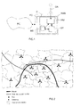
D'autres caractéristiques et avantages de l'invention apparaîtront à l'examen de la description détaillée ci-après, et des dessins annexés, sur lesquels :
- la
figure 1 illustre de façon très schématique et fonctionnelle un système de gestion de réseau équipé d'un exemple de réalisation d'un dispositif d'optimisation selon l'invention, - la
figure 2 illustre un exemple de carte de zone géographique matérialisant des sites et les cellules associées, ainsi que des axes de transport (route et voies de chemin de fer), - la
figure 3 est identique à lafigure 2 , mais avec en complément la matérialisation, en gris, des cellules qui englobent les axes de transport (définis dans la légende) et, en traits discontinus (LZ), de limites entre zones de localisation fournies par un utilisateur, - la
figure 4 est identique à lafigure 3 , mais avec en complément la matérialisation, en lignes de type tiret-point (FZ), d'un premier exemple de frontières entre zones de localisation déterminées par le dispositif d'optimisation selon l'invention, - la
figure 5 est identique à lafigure 4 , mais sans les limites (LZ) et avec en complément la matérialisation des sites associés à des cellules appartenant à des zones de localisation différentes et le signalement des cellules que l'utilisateur souhaite inclure dans des zones de localisation différentes de celles auxquelles elles appartiennent dans le premier exemple de frontières, - la
figure 6 est identique à lafigure 4 , mais sans les limites (LZ) et avec en complément la matérialisation en lignes de type tiret-point (FZ) d'un deuxième exemple de frontières entre zones de localisation déterminées par le dispositif d'optimisation selon l'invention et prenant en compte une contrainte d'intégration de cellules fournie par l'utilisateur, - la
figure 7 est identique à lafigure 6 , mais avec en complément la matérialisation dans les différentes cellules de la première zone de localisation (LA1) des valeurs prises par un indicateur de trafic, - la
figure 8 illustre un troisième exemple de frontières entre zones de localisation déterminées par le dispositif d'optimisation selon l'invention dans le cas d'une prise en compte d'une contrainte sur les valeurs prises par un indicateur de trafic dans les cellules traversées par la route, fournie par l'utilisateur, - la
figure 9 illustre un quatrième exemple de frontières entre zones de localisation déterminées par le dispositif d'optimisation selon l'invention à partir de la carte de lafigure 8 et dans le cas d'une prise en compte de contraintes sur l'intégration de cellules et sur l'interdiction de fractionnement des zones de localisation, fournies par l'utilisateur.
- the
figure 1 illustrates very schematically and functionally a network management system equipped with an embodiment of an optimization device according to the invention, - the
figure 2 illustrates an example of a geographical area map showing sites and associated cells, as well as transport axes (road and railroad tracks), - the
figure 3 is identical to thefigure 2 , but in addition to the materialization, in gray, of cells that include the transport axes (defined in the legend) and, in broken lines (LZ), boundaries between location areas provided by a user, - the
figure 4 is identical to thefigure 3 , but in addition to the materialization, in dash-dot lines (FZ), of a first example of boundaries between location zones determined by the optimization device according to the invention, - the
figure 5 is identical to thefigure 4 , but without the limits (LZ) and with the addition of the materialization of the sites associated with cells belonging to different localization zones and the signaling of the cells that the user wishes to include in zones of localization different from those to which they belong in the first example of borders, - the
figure 6 is identical to thefigure 4 , but without the limits (LZ) and in addition to the materialization in dash-dot lines (FZ) of a second example of boundaries between location zones determined by the optimization device according to the invention and taking into account a cell integration constraint provided by the user, - the
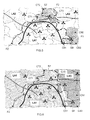
figure 7 is identical to thefigure 6 , but with in addition the materialization in the different cells of the first location area (LA1) of the values taken by a traffic indicator, - the
figure 8 illustrates a third example of boundaries between location zones determined by the optimization device according to the invention in the case of taking into account a constraint on the values taken by a traffic indicator in the cells crossed by the road , provided by the user, - the
figure 9 illustrates a fourth example of boundaries between location zones determined by the optimization device according to the invention from the map of thefigure 8 and in the case of taking into account constraints on the integration of cells and on the prohibition of splitting of the location zones, provided by the user.
Les dessins annexés pourront non seulement servir à compléter l'invention, mais aussi contribuer à sa définition, le cas échéant.The attached drawings may not only serve to complete the invention, but also contribute to its definition, if any.
L'invention a pour objet de permettre la définition au moins partiellement automatique, principalement basée sur des informations à composante géographique (localisée), de la définition de zones de localisation dans une partie au moins d'un réseau de communication cellulaire, tout en laissant (à l'opérateur du réseau) la possibilité de modifier manuellement cette définition pour prendre en compte, par exemple, des informations dont il dispose mais qui ne sont pas connues du système de gestion du réseau.The object of the invention is to allow the definition of at least partially automatic, mainly based on geographical component information (localized), defining location areas in at least part of a cellular communication network, while leaving (to the network operator) the possibility of modifying manually this definition to take into account, for example, information which it has but which are not known to the network management system.
Dans ce qui suit, on considère à titre d'exemple non limitatif que le réseau de communication cellulaire est un réseau de téléphonie cellulaire (ou mobile), comme par exemple un réseau GSM, ou GPRS/EDGE, ou UMTS, ou encore CDMA2000. Mais, l'invention n'est pas limitée à ce type de réseau cellulaire. Elle concerne en effet tout type de réseau de communication radio, et notamment les réseaux locaux sans fil (standards WLAN (« Wireless Local Area Network » - IEEE 802.11, Wi-Fi, ETSI HiperLAN/2), Bluetooth (IEEE 802.15), WiMAX (IEEE 802.16, ETSI HiperMAN) et Zigbee). D'une manière générale, l'invention concerne tout type de réseau dans lequel le concept de décomposition en zones de localisation (ou location areas (LACs)) nécessite un paramétrage pouvant être adapté.In what follows, it is considered as a non-limiting example that the cellular communication network is a cellular (or mobile) network, such as a GSM network, or GPRS / EDGE, or UMTS, or CDMA2000. But, the invention is not limited to this type of cellular network. It concerns any type of radio communication network, including wireless local area networks (Wireless Local Area Network (IEEE 802.11, Wi-Fi, ETSI HiperLAN / 2), Bluetooth (IEEE 802.15), WiMAX (IEEE 802.16, ETSI HiperMAN) and Zigbee). In general, the invention relates to any type of network in which the concept of decomposition into areas of location (or location areas (LACs)) requires a setting that can be adapted.
Il est rappelé qu'un réseau cellulaire (RC) peut être schématiquement résumé à un réseau de commutation (ou « Core Network ») couplé à un réseau d'accès radio (appelé UTRAN dans le cas d'un réseau UMTS et BSS dans le cas d'un réseau GSM), lui-même raccordé à un système de gestion de réseau ou NMS (pour « Network Management System »).It is recalled that a cellular network (RC) can be schematically summarized to a switching network (or "Core Network") coupled to a radio access network (called UTRAN in the case of a UMTS and BSS network in the case of a GSM network), itself connected to a network management system or NMS (for "Network Management System").
Le réseau RC comporte des éléments (ou équipements) de réseau. On entend ici par « élément (ou équipement) de réseau » tout constituant (physique et/ou logique) d'un réseau par lequel passent des trafics qui peuvent être définis localement par des valeurs de paramètre(s) ou d'indicateur(s) (par exemple de qualité de service (QoS)) pouvant être mesuré(e)s ou estimé(e)s par le système de gestion de réseau (NMS). Il pourra donc s'agir, par exemple, d'une cellule dans laquelle des terminaux mobiles peuvent établir ou poursuivre des communications, ou d'un équipement de réseau, tel qu'un routeur, une station de base (Node B dans le cas d'un réseau UMTS et BTS dans le cas d'un réseau GSM), ou un contrôleur de réseau radio (RNC dans le cas d'un réseau UMTS et BSC dans le cas d'un réseau GSM). II est rappelé qu'une station de base (Node B ou BTS) est implantée dans un site Si (i = 1 à N), de position géographique connue, et comporte au moins une antenne associée à une cellule de position géographique connue (et éventuellement à un ou plusieurs secteurs). Par ailleurs, chaque contrôleur de réseau radio (RNCs ou BSCs) contrôle au moins deux (généralement plusieurs dizaines, voire plusieurs centaines) stations de base (ou équivalent), et est notamment chargé de l'allocation des canaux radio, de la réception des mesures effectuées par les terminaux mobiles et du contrôle des transferts entre stations de base (ou « handovers »).The RC network comprises network elements (or equipment). The term "network element (or equipment)" is understood here to mean any constituent (physical and / or logical) of a network through which traffics which may be locally defined by parameter (s) or indicator (s) values are passed. ) (eg quality of service (QoS)) that can be measured or estimated by the Network Management System (NMS). It may be, for example, a cell in which mobile terminals can establish or continue communications, or network equipment, such as a router, a base station (Node B in the case of a UMTS and BTS network in the case of a GSM network), or a radio network controller (RNC in the case of a UMTS and BSC network in the case of a GSM network). It is recalled that a base station (Node B or BTS) is located in a site Si (i = 1 to N), of known geographical position, and comprises at least one antenna associated with a known geographical position cell (and possibly to one or more sectors). Furthermore, each radio network controller (RNCs or BSCs) controls at least two (usually several tens or even hundreds) base stations (or equivalent), and is in particular responsible for the allocation of radio channels, the reception of measurements made by mobile terminals and the control of transfers between base stations (or "handovers").
Certains au moins des éléments (ou équipements) de réseau mentionnés ci-dessus constituent des objets (de réseau). C'est notamment le cas des stations de base (Node Bs et BTSs), des contrôleurs de réseau radio (RNCs et BSCs) et des cellules. On notera que les objets peuvent être des éléments de réseau ou bien des éléments de topologie de réseau comme par exemple des adjacences.At least some of the network elements (or equipment) mentioned above are (network) objects. This is particularly the case for base stations (Node Bs and BTSs), radio network controllers (RNCs and BSCs) and cells. It will be noted that the objects may be network elements or network topology elements such as, for example, adjacencies.
L'invention propose d'équiper un réseau cellulaire RC d'au moins un dispositif D chargé d'optimiser le fonctionnement (et/ou la configuration) de l'une au moins de ses parties implantée dans une zone géographique connue.The invention proposes to equip a cellular network RC of at least one device D responsible for optimizing the operation (and / or configuration) of at least one of its parts implanted in a known geographical area.
Comme cela est schématiquement et fonctionnellement illustré à titre d'exemple non limitatif sur la
Comme illustré, cet équipement de gestion EG peut lui-même faire éventuellement partie du système de gestion de réseau NMS. Dans une variante, le dispositif d'optimisation D peut constituer à lui seul un équipement de gestion EG pouvant éventuellement faire partie du (ou être couplé au) système de gestion de réseau NMS. Ainsi, un dispositif d'optimisation D peut faire partie d'un (ou constituer un) outil d'optimisation de réseau, par exemple de type RNO® ou NPO®.As illustrated, this management equipment EG may itself be part of the NMS network management system. In one variant, the optimization device D may constitute on its own an EG management equipment that may possibly be part of (or be coupled to) the NMS network management system. Thus, an optimization device D can be part of a network optimization tool (for example of the RNO® or NPO® type).
Un dispositif d'optimisation D selon l'invention comprend au moins un module de traitement MT chargé d'intervenir chaque fois qu'une zone géographique (couverte par le réseau RC) et au moins un critère cartographique (présentant au moins une relation avec des objets du réseau cellulaire RC) ont été sélectionnés, afin de constituer, au sein de cette zone géographique sélectionnée et en fonction de chaque critère cartographique sélectionné, des groupes de cellules définissant chacun une zone de localisation (ou local area) LAj.An optimization device D according to the invention comprises at least one an MT processing module responsible for intervening whenever a geographical area (covered by the RC network) and at least one cartographic criterion (having at least one relation with objects of the cellular network RC) have been selected, in order to constitute, within this selected geographical area and according to each selected cartographic criterion, groups of cells each defining a local area LAj.
Chaque critère cartographique est sélectionné parmi une liste qui est stockée dans des moyens de stockage MS qui font partie préférentiellement, mais pas obligatoirement, du dispositif d'optimisation D. Ils pourraient en effet faire partie de l'équipement de gestion EG dans lequel est éventuellement implanté le dispositif d'optimisation D, ou bien du système de gestion de réseau NMS, l'important étant que leur contenu soit accessible au dispositif d'optimisation D.Each cartographic criterion is selected from a list which is stored in storage means MS which are preferably but not necessarily part of the optimization device D. They could indeed be part of the management equipment EG in which it is possible. implemented the optimization device D, or the network management system NMS, the important thing is that their content is accessible to the optimization device D.
Ces moyens de stockage MS stockent également les positions géographiques de certains au moins des objets du réseau, et notamment les stations de base, les contrôleurs de réseau radio et les cellules.These storage means MS also store the geographical positions of at least some of the objects of the network, and in particular the base stations, the radio network controllers and the cells.
De préférence, ces moyens de stockage MS stockent également d'autres informations, comme par exemple et non limitativement, les positions géographiques des axes de transport (routes, voies de chemin de fer, voies fluviales, canaux) et des bâtiments et/ou des informations relatives à l'occupation du sol (immeuble d'habitation, immeuble de bureau, école, usine, aéroport, gare, port, musée, centre de conférences ou de spectacle, cinéma, centre commercial ou stade de sport) et/ou des valeurs prises par des indicateurs, compteurs ou paramètres dans des cellules et/ou des informations relatives au relief dans une (des) zone(s) géographique(s). Les moyens de stockage MS peuvent également stocker les données définissant la (les) carte(s) géographique(s) (éventuellement avec les reliefs) des zones dans lesquelles le réseau cellulaire RC est implanté.Preferably, these storage means MS also store other information, such as, for example and without limitation, the geographical positions of the transport axes (roads, railways, waterways, canals) and buildings and / or land-use information (residential building, office building, school, factory, airport, railway station, port, museum, conference or performance center, cinema, shopping center or sports stadium) and / or values taken by indicators, counters or parameters in cells and / or relief information in a geographical area (s). The storage means MS can also store the data defining the geographical map (s) (possibly with the reliefs) of the areas in which the cellular network RC is implanted.
De façon générale, toute donnée de nature géographique et sous jacente pourra être utilisée comme critère de détermination de zone de localisation (LAC) par le dispositif D. Par ailleurs, ces données peuvent résulter d'observations directes ou indirectes (comme par exemple un sondage) et/ou peuvent être des données prévisionnelles (comme par exemple une nouvelle route). En outre, ces données ne couvrent pas forcément toute la zone d'analyse.In general, any data of a geographical and underlying nature may be used as a criterion for determination of location area (LAC) by the device D. Moreover, these data may result from direct or indirect observations (for example a survey) and / or may be forecast data (such as a new route). In addition, these data do not necessarily cover the entire analysis area.
On notera qu'une partie des informations précitées peut être stockée dans l'équipement de gestion EG dans lequel est éventuellement implanté le dispositif d'optimisation D, ou bien dans une partie du système de gestion de réseau NMS, l'important étant qu'ils soient accessibles au dispositif d'optimisation D.It should be noted that part of the aforementioned information can be stored in the management equipment EG in which the optimization device D is optionally implemented, or in part of the network management system NMS, the important thing being that they are accessible to the optimization device D.
Les moyens de stockage MS peuvent se présenter sous n'importe quelle forme, et notamment sous la forme d'une mémoire ou d'une base de données ou encore d'un système de gestion de fichiers.The storage means MS can be in any form, and especially in the form of a memory or a database or a file management system.
Les critères cartographiques peuvent être de tout type dès lors qu'ils peuvent être utiles à la détermination de zones de localisation (ou location areas). Mais, de préférence, les critères cartographiques sont choisis parmi des critères géographiques, des critères d'occupation d'une zone géographique et des critères de communication.Map criteria can be of any type as long as they can be useful for determining location areas. But, preferably, the cartographic criteria are chosen from geographical criteria, occupancy criteria of a geographical area and communication criteria.
Par exemple, les critères géographiques peuvent être choisis parmi (au moins) des critères de sélection d'objets de positions géographiques connues (comme par exemple les sites (ou stations de base) Si et/ou les cellules Cik), des critères de localisation, et le relief au sein d'une zone géographique (par exemple donné par un modèle d'élévation numérique (vue tridimensionnelle)).For example, the geographical criteria can be selected from (at least) criteria for selecting objects of known geographical positions (such as sites (or base stations) If and / or Cik cells), location criteria , and the relief within a geographical area (for example given by a digital elevation model (three-dimensional view)).
Par exemple, les critères d'occupation d'une zone géographique peuvent être choisis parmi (au moins) des critères de sélection d'axes de transport (routes, voies de chemin de fer, voies fluviales, canaux et analogues) et des critères de sélection liés à tout type d'occupation d'une zone géographique (immeuble d'habitation, immeuble de bureau, école, usine, aéroport, gare, port, musée, centre de conférences ou de spectacle, cinéma, centre commercial, stade de sport, ou analogue). D'une manière générale, et comme indiqué précédemment, toute donnée à dimension géographique présente dans une carte pourra être utilisée en entrée par le dispositif D lors de son assistance à la définition des zones de localisation (LACs).For example, occupation criteria for a geographical area may be selected from (at least) criteria for the selection of transport axes (roads, railways, waterways, canals and the like) and criteria for selection related to any type of occupation of a geographical area (residential building, office building, school, factory, airport, railway station, port, museum, conference or entertainment center, cinema, shopping center, sports stadium , or the like). In general, and as indicated above, any geographic dimension data present in a map can be used as input by the device D during its assistance in defining the location areas (LACs).
Par exemple, les critères de communication peuvent être choisis parmi (au moins) la couverture radio qui est liée aux définitions géographiques des cellules, des critères de sélection de compteurs et/ou d'indicateurs de qualité de service (QoS), et un critère de sélection d'une décomposition connue en zones de localisation (éventuellement déterminée précédemment avec le dispositif D compte tenu de certain(s) critère(s) et d'éventuelle(s) contrainte(s))For example, the communication criteria can be selected from (at least) the radio coverage that is related to the geographic definitions of the cells, the criteria for selecting meters and / or quality of service (QoS) indicators, and a criterion for selecting a known decomposition into localization zones (possibly determined previously with the device D taking into account certain criterion (s) and possible constraint (s))
On notera que certaines décompositions en zones de localisation peuvent être des invariants qui sont stockés et qui servent de base à l'élaboration de nouvelles décompositions. Par conséquent, ces invariants ne peuvent pas être modifiés. On peut également stocker certaines au moins des décompositions déterminées au moyen du dispositif D, selon un classement temporel (ou « historisé »), afin de les utiliser pour déterminer de futures décompositions.It should be noted that some decompositions in localization zones can be invariants that are stored and serve as a basis for the development of new decompositions. Therefore, these invariants can not be modified. It is also possible to store at least certain decompositions determined by means of the device D, according to a temporal (or "historized") classification, in order to use them to determine future decompositions.
Parmi les compteurs et indicateurs que l'on peut utiliser, on notera notamment et non limitativement, les flux de handovers (qui permettent de déterminer si les dimensions des zones de localisation sont appropriées), les mises à jour des positions des terminaux mobiles, les quantités de messages de paging ou de signalisation au sein d'une même zone de localisation, et les taux de succès de paging (fournis par le NSS dans le cas d'un réseau GSM et utiles pour déterminer la pertinence des contours des zones de localisation).Among the counters and indicators that can be used, it will be noted, in particular and not limited to, the handover flows (which make it possible to determine whether the dimensions of the location areas are appropriate), the updates of the positions of the mobile terminals, the quantities of paging or signaling messages within the same location area, and paging success rates (provided by the NSS in the case of a GSM network and useful for determining the relevance of the contours of the location areas ).
Le module de traitement MT est chargé d'intervenir chaque fois qu'une zone géographique couverte par le réseau RC et l'un au moins des critères cartographiques stockés dans les moyens de stockage MS ont été sélectionnés.The processing module MT is responsible for intervening whenever a geographical area covered by the network RC and at least one of the cartographic criteria stored in the storage means MS have been selected.
Cette sélection peut être fournie au dispositif d'optimisation D par un équipement du réseau cellulaire RC ou de l'opérateur du réseau, ou bien par un utilisateur (ou gestionnaire de réseau) GR. Dans ce dernier cas, la sélection se fait au moyen d'une interface homme/machine IHM qui peut faire partie, au moins partiellement, du dispositif D (comme illustré) ou de l'éventuel équipement de gestion EG ou du NMS. Lorsque le dispositif D comprend les moyens de stockage MS, il doit également comprendre une partie au moins de l'interface homme/machine IHM, couplée aux moyens de stockage MS et au module de traitement MT afin, d'une part, de permettre à un utilisateur GR d'effectuer sa sélection de zone géographique et de critère(s), et d'autre part, de communiquer la définition de la sélection au module de traitement MT en vue de la détermination de zone(s) de localisation LAj.This selection can be provided to the optimization device D by a device of the cellular network RC or the operator of the network, or by a user (or network manager) GR. In the latter case, the selection is made by means of an HMI man / machine interface which may be part, at least partially, of the device D (as illustrated) or of the possible management equipment EG or the NMS. When the device D comprises the storage means MS, it must also comprise at least part of the human / machine interface HMI, coupled to the storage means MS and to the processing module MT to, firstly, to allow a GR user to make his selection of geographical area and criterion (s), and secondly, to communicate the definition of the selection to the processing module MT for the determination of localization area (s) LAj.
Cette interface homme/machine IHM est constituée de tout élément informatique permettant à un utilisateur GR d'effectuer ses sélections et des saisies de données sur l'écran destiné à afficher les cartes matérialisant les zones géographiques sélectionnées et les résultats du travail du dispositif D compte tenu des critères cartographiques sélectionnés. Elle comprend par exemple un clavier de saisie et une souris, ainsi qu'éventuellement un écran tactile.This HMI man / machine interface consists of any computer element allowing a GR user to make his selections and data entries on the screen intended to display the maps materializing the selected geographical areas and the results of the work of the device D account selected cartographic criteria. It includes for example a keyboard input and a mouse, and possibly a touch screen.
On notera que l'interface homme/machine IHM peut également (et éventuellement) permettre à l'utilisateur GR de fournir au moins une contrainte, soit avant que le module de traitement MT ait déterminé des zones de localisation LAj, soit après qu'il ait déterminé des zones de localisation LAj avec le(s) critère(s) cartographique(s) sélectionné(s). En effet, dans une variante avantageuse le module de traitement MT peut être agencé de manière à constituer, au sein d'une zone géographique sélectionnée et en fonction de chaque critère cartographique sélectionné et de chaque contrainte fournie, des groupes de cellules définissant chacun une zone de localisation.Note that the human-machine interface HMI can also (and possibly) allow the GR user to provide at least one constraint, either before the processing module MT has determined location areas LAj, or after it has determined location areas LAj with the selected map criterion (s). Indeed, in an advantageous variant, the processing module MT can be arranged so as to constitute, within a selected geographical zone and according to each selected cartographic criterion and each constraint provided, groups of cells each defining a zone location.
Dans cette variante l'utilisateur GR peut donc modifier à tout moment le(s) critère(s) sélectionné(s) et/ou adjoindre à ce(s) dernier(s) une ou plusieurs contraintes.In this variant, the user GR can therefore modify at any time the criterion (s) selected (s) and / or add to this (s) last (s) one or more constraints.
Tout type de contrainte cartographique, et donc ayant une relation avec les objets ou les compteurs ou indicateurs associés, peut être utilisé. Ainsi, une contrainte peut porter sur une valeur d'indicateur ou de compteur ou bien sur au moins une limite (grossière) définie par l'utilisateur GR au moyen d'une ligne sur la carte qui représente la zone géographique objet de l'optimisation et qui est affichée sur l'écran qui est couplé au dispositif D.Any type of cartographic constraint, and therefore having a relationship with the objects or the associated counters or indicators, can be used. Thus, a constraint may relate to an indicator or counter value or at least one (rough) limit defined by the user GR by means of a line on the map that represents the geographic area being optimized. and which is displayed on the screen that is coupled to the device D.
On va maintenant décrire des exemples non limitatifs d'utilisation du dispositif D (et donc du procédé d'optimisation) en référence aux
On a représenté sur la
On a représenté sur la
On a représenté sur la
A ce stade, on dispose d'un premier exemple de frontières FZ entre zones de localisation LAj.At this stage, there is a first example of FZ boundaries between location areas LAj.
Comme on l'observe mieux sur la
On notera que le module de traitement MT peut éventuellement être agencé de manière à générer une alarme destinée à être affichée sur l'écran afin de signaler à l'utilisateur l'existence de sites possédant des cellules appartenant à des zones de localisation différentes. Par exemple, et comme illustré sur la
A ce stade, l'utilisateur GR peut par exemple fournir au module de traitement MT de nouvelles contraintes pour qu'il détermine de nouvelles frontières de zones de localisation LAj, compte tenu de ces dernières. Ici, les nouvelles contraintes consistent, d'une part, à intégrer dans la zone de localisation LA1 les cellules C72 et C73 du site S7 (flèches F1 et F2) contenues dans la zone de localisation LA3, et d'autre part, à intégrer dans la zone de localisation LA3 la cellule C91 du site S9 (flèche F3) contenue dans la zone de localisation LA1.At this stage, the user GR can, for example, provide the processing module MT with new constraints so that it determines new boundaries of location areas LAj, taking into account the latter. Here, the new constraints consist, on the one hand, of integrating into the location area LA1 the cells C72 and C73 of the site S7 (arrows F1 and F2) contained in the location area LA3, and on the other hand, to integrate in the LA3 localization zone, the C91 cell of the S9 site (arrow F3) contained in the LA1 localization zone.
On a représenté sur la
On notera qu'il est également possible d'agencer le module de traitement MT de sorte qu'il délivre un bilan relatif aux zones de localisation déterminées LAj. Par exemple, un tel bilan peut comporter pour chaque zone de localisation déterminée LAj le nombre de cellules, la surface occupée et le nombre d'habitants. Les informations contenues dans ce bilan peuvent être éventuellement choisies par l'utilisateur GR.Note that it is also possible to arrange the processing module MT so that it delivers a report relative to the determined location areas LAj. For example, such a balance sheet may include for each determined location area LAj the number of cells, the area occupied and the number of inhabitants. The information contained in this report may be optionally selected by the GR user.
On notera également qu'il est possible de sauvegarder, par exemple dans les moyens de stockage MS, une décomposition en zones de localisation LAj. Ainsi, une décomposition en zones de localisation peut à tout instant servir de base à une nouvelle détermination de zones de localisation, pour la même zone géographique (ou une zone plus restreinte). C'est notamment le cas de l'exemple illustré sur la
Plus précisément, on considère dans le cas de la
L'utilisateur GR considérant que le trafic est trop important dans les cellules par lesquelles passent la route et une partie des voies de chemin de fer, il sélectionne un nouveau critère consistant à définir une zone de localisation englobant la route. Puis, il demande au dispositif D d'appliquer ce nouveau critère à la carte de la
On a représenté sur la
On notera que le module de traitement MT peut éventuellement être agencé de manière à générer une alarme destinée à être affichée sur l'écran afin de signaler à l'utilisateur l'existence d'une zone de localisation séparée en plusieurs parties disjointes. Par exemple, et comme illustré sur la
A ce stade, l'utilisateur GR peut par exemple fournir manuellement au module de traitement MT de nouvelles contraintes pour qu'il détermine de nouvelles frontières de zones de localisation LAj, compte tenu de ces dernières. Ici, les nouvelles contraintes consistent, d'une part, à interdire le fractionnement d'une zone de localisation, et d'autre part, à interdire qu'un site possède des cellules appartenant à plusieurs zones de localisation différentes.At this stage, the user GR can, for example, manually provide the processing module MT with new constraints so that it determines new boundaries of location areas LAj, taking into account these latest. Here, the new constraints consist, on the one hand, to prohibit the splitting of a location area, and on the other hand, to prohibit a site has cells belonging to several different location areas.
Il est important de noter que l'utilisateur GR peut interagir manuellement à tout moment avec la carte qui est délivrée par le dispositif D. Il est donc possible d'ajouter et/ou retirer des contributions à la main de manière à affiner une carte, y compris intermédiaire, délivrée de façon automatisée par le dispositif D.It is important to note that the GR user can manually interact at any time with the card that is delivered by the device D. It is therefore possible to add and / or remove contributions by hand so as to refine a card, including intermediate, delivered automatically by the device D.
On a représenté sur la
De nouveau, un bilan peut être éventuellement demandé au dispositif D afin d'être affiché sur l'écran.Again, a report may possibly be requested to the device D to be displayed on the screen.
Le dispositif d'optimisation D selon l'invention, et notamment son module de traitement MT, et ses éventuels moyens de stockage et interface homme/machine IHM, peuvent être réalisés sous la forme de modules logiciels (ou informatiques), de circuits électroniques, ou d'une combinaison de circuits et de logiciels, voire même de périphérique(s) informatique(s).The optimization device D according to the invention, and in particular its processing module MT, and its possible storage means and human-machine interface HMI, can be realized in the form of software (or computer) modules, electronic circuits, or a combination of circuits and software, or even computer peripheral (s).
Grâce à l'invention, il est désormais possible d'automatiser au moins partiellement la détermination des zones de localisation d'une partie au moins d'un réseau de communication cellulaire, quel qu'en soit le standard, et y compris s'il s'agit d'un réseau multi-standards, tout en laissant la possibilité à l'opérateur d'intervenir manuellement à tout moment dans un résultat de détermination.Thanks to the invention, it is now possible to at least partially automate the determination of the location zones of at least part of a cellular communication network, whatever the standard, and even if This is a multi-standard network, while allowing the operator to intervene manually at any time in a determination result.
L'invention ne se limite pas aux modes de réalisation de dispositif d'optimisation et d'équipement de gestion de réseau décrits ci-avant, seulement à titre d'exemple, mais elle englobe toutes les variantes que pourra envisager l'homme de l'art dans le cadre des revendications ci-après.The invention is not limited to the embodiments of optimization device and network management equipment described above, only by way of example, but it encompasses all variants that can consider those skilled in the art within the scope of the claims below.
Claims (19)
Applications Claiming Priority (1)
| Application Number | Priority Date | Filing Date | Title |
|---|---|---|---|
| FR0755439A FR2916932B1 (en) | 2007-06-04 | 2007-06-04 | DEVICE AND METHOD FOR OPTIMIZING THE OPERATION OF A CELLULAR COMMUNICATION NETWORK BY ASSISTED DEFINITION OF LACALIZATION AREAS. |
Publications (2)
| Publication Number | Publication Date |
|---|---|
| EP2111069A1 true EP2111069A1 (en) | 2009-10-21 |
| EP2111069B1 EP2111069B1 (en) | 2013-03-06 |
Family
ID=38870349
Family Applications (1)
| Application Number | Title | Priority Date | Filing Date |
|---|---|---|---|
| EP20080156373 Not-in-force EP2111069B1 (en) | 2007-06-04 | 2008-05-16 | Device and method for optimising the operation of a cellular communication network by assisted definition of localisation areas |
Country Status (2)
| Country | Link |
|---|---|
| EP (1) | EP2111069B1 (en) |
| FR (1) | FR2916932B1 (en) |
Citations (4)
| Publication number | Priority date | Publication date | Assignee | Title |
|---|---|---|---|---|
| WO2001078421A2 (en) * | 2000-04-10 | 2001-10-18 | Telefonaktiebolaget L M Ericsson (Publ) | Self-configurable paging system for a cellular telecommunications network |
| US20050059404A1 (en) | 2003-09-15 | 2005-03-17 | Yigal Bejerano | Methods and devices for grouping cells |
| WO2006052269A2 (en) | 2004-11-05 | 2006-05-18 | Ta-Gang Chiou | System with a user interface for network planning and mobility management optimization in a mobile communication network and method thereof |
| WO2006079210A1 (en) * | 2005-01-28 | 2006-08-03 | Nortel Networks Limited | Method and system for determining a paging zone in a wireless network |
-
2007
- 2007-06-04 FR FR0755439A patent/FR2916932B1/en not_active Expired - Fee Related
-
2008
- 2008-05-16 EP EP20080156373 patent/EP2111069B1/en not_active Not-in-force
Patent Citations (4)
| Publication number | Priority date | Publication date | Assignee | Title |
|---|---|---|---|---|
| WO2001078421A2 (en) * | 2000-04-10 | 2001-10-18 | Telefonaktiebolaget L M Ericsson (Publ) | Self-configurable paging system for a cellular telecommunications network |
| US20050059404A1 (en) | 2003-09-15 | 2005-03-17 | Yigal Bejerano | Methods and devices for grouping cells |
| WO2006052269A2 (en) | 2004-11-05 | 2006-05-18 | Ta-Gang Chiou | System with a user interface for network planning and mobility management optimization in a mobile communication network and method thereof |
| WO2006079210A1 (en) * | 2005-01-28 | 2006-08-03 | Nortel Networks Limited | Method and system for determining a paging zone in a wireless network |
Non-Patent Citations (1)
| Title |
|---|
| CAMBRAY-DE MATHAN DE B ET AL: "L'OPTIMISATION DES RESEAUX CELLULAIRES ASSISTEE PAR ORDINATEUR: LE LOGICIEL RNO (RADIO NETWORK OPTIMISATION) COMPUTER-AIDED OPTIMIZATION OF CELLULAR NETWORKS: THE RNO (RADIO NETWORK OPTIMISATION) SOFTWARE", ANNALES DES TELECOMMUNICATIONS - ANNALS OF TELECOMMUNICATIONS, GET LAVOISIER, PARIS, FR, vol. 58, no. 7/8, July 2003 (2003-07-01), pages 964 - 1000, XP001186072, ISSN: 0003-4347 * |
Also Published As
| Publication number | Publication date |
|---|---|
| FR2916932A1 (en) | 2008-12-05 |
| FR2916932B1 (en) | 2009-09-25 |
| EP2111069B1 (en) | 2013-03-06 |
Similar Documents
| Publication | Publication Date | Title |
|---|---|---|
| US10341878B2 (en) | Connection technology-based wireless coverage verification | |
| US10419949B2 (en) | Web server and method for hosting a web page for presenting location based user quality data related to a communication network | |
| US9706414B2 (en) | Method and apparatus for determining data flow rate on service access port | |
| FR2687520A1 (en) | METHOD FOR IMPLANTING THE INFRASTRUCTURE OF A CELLULAR COMMUNICATION NETWORK | |
| CN107920362A (en) | A kind of LTE network performance estimating method based on film micro area | |
| EP2198644B1 (en) | Radio measurement in a radio communication network | |
| EP1465447B1 (en) | Method for calculating and displaying mutual interference in the downlink for W-CDMA radio networks | |
| CN112689329A (en) | Beam configuration method and device, electronic equipment and computer storage medium | |
| US12238534B2 (en) | Network expansion optimization | |
| EP1389026A1 (en) | Device and method of processing location data for a mobile telephone | |
| CN106056515A (en) | Community grid event cluster feature extraction method | |
| EP1434453B1 (en) | Method and system for creating, managing and using traffic distribution maps in a radio communication system | |
| CN106998581A (en) | A kind of method for connecting network and device, computer installation, readable storage medium storing program for executing | |
| EP2111069B1 (en) | Device and method for optimising the operation of a cellular communication network by assisted definition of localisation areas | |
| EP2023532B1 (en) | System and method of analysing data relating to the objects of a communication network | |
| FR2880505A1 (en) | METHOD AND SYSTEM FOR OPERATING A MOBILE COMMUNICATIONS NETWORK | |
| WO2025004093A1 (en) | System and method for providing a centralized network master database lake for network nodes | |
| Alepis et al. | Mapping the wireless coverage grid for carrier and user recommendations through crowdsourcing | |
| EP1724975A1 (en) | Apparatus for analysis of modified analysis data for communications network optimization | |
| FR2884383A1 (en) | CARTOGRAPHIC ANALYSIS DATA ANALYSIS DEVICE FOR OPTIMIZATION OF A COMMUNICATION NETWORK | |
| CN108710139A (en) | A kind of information processing method, device and its system based on GPS real time position big datas | |
| FR2888453A1 (en) | Data e.g. traffic data, analysis device for e.g. GSM network, has collection unit to observe data, upon request, to collect data which satisfies chosen triggering criteria to store data corresponding to each other for analyzing data | |
| EP4544807A1 (en) | Collection of cell deployment information | |
| EP1670271B1 (en) | Optimisation of multistandard radio access and/or core network that interact | |
| WO2024002866A1 (en) | Communication, management and discovery methods, and devices configured to carry out said methods |
Legal Events
| Date | Code | Title | Description |
|---|---|---|---|
| PUAI | Public reference made under article 153(3) epc to a published international application that has entered the european phase |
Free format text: ORIGINAL CODE: 0009012 |
|
| PUAI | Public reference made under article 153(3) epc to a published international application that has entered the european phase |
Free format text: ORIGINAL CODE: 0009012 |
|
| AK | Designated contracting states |
Kind code of ref document: A1 Designated state(s): AT BE BG CH CY CZ DE DK EE ES FI FR GB GR HR HU IE IS IT LI LT LU LV MC MT NL NO PL PT RO SE SI SK TR |
|
| AX | Request for extension of the european patent |
Extension state: AL BA MK RS |
|
| 17P | Request for examination filed |
Effective date: 20100421 |
|
| 17Q | First examination report despatched |
Effective date: 20100521 |
|
| AKX | Designation fees paid |
Designated state(s): AT BE BG CH CY CZ DE DK EE ES FI FR GB GR HR HU IE IS IT LI LT LU LV MC MT NL NO PL PT RO SE SI SK TR |
|
| RAP1 | Party data changed (applicant data changed or rights of an application transferred) |
Owner name: ALCATEL LUCENT |
|
| REG | Reference to a national code |
Ref country code: DE Ref legal event code: R079 Ref document number: 602008022653 Country of ref document: DE Free format text: PREVIOUS MAIN CLASS: H04W0016000000 Ipc: H04W0016180000 |
|
| RIC1 | Information provided on ipc code assigned before grant |
Ipc: H04W 16/18 20090101AFI20120731BHEP |
|
| GRAP | Despatch of communication of intention to grant a patent |
Free format text: ORIGINAL CODE: EPIDOSNIGR1 |
|
| RIN1 | Information on inventor provided before grant (corrected) |
Inventor name: HOULLIER, JEAN-ROCH Inventor name: SALOMON, ERIC Inventor name: DE MATHAN, BEATRIX Inventor name: BRETHEREAU, ALAIN |
|
| GRAS | Grant fee paid |
Free format text: ORIGINAL CODE: EPIDOSNIGR3 |
|
| GRAA | (expected) grant |
Free format text: ORIGINAL CODE: 0009210 |
|
| AK | Designated contracting states |
Kind code of ref document: B1 Designated state(s): AT BE BG CH CY CZ DE DK EE ES FI FR GB GR HR HU IE IS IT LI LT LU LV MC MT NL NO PL PT RO SE SI SK TR |
|
| REG | Reference to a national code |
Ref country code: GB Ref legal event code: FG4D Free format text: NOT ENGLISH |
|
| REG | Reference to a national code |
Ref country code: CH Ref legal event code: EP Ref country code: AT Ref legal event code: REF Ref document number: 600194 Country of ref document: AT Kind code of ref document: T Effective date: 20130315 |
|
| REG | Reference to a national code |
Ref country code: IE Ref legal event code: FG4D Free format text: LANGUAGE OF EP DOCUMENT: FRENCH |
|
| REG | Reference to a national code |
Ref country code: DE Ref legal event code: R096 Ref document number: 602008022653 Country of ref document: DE Effective date: 20130502 |
|
| REG | Reference to a national code |
Ref country code: AT Ref legal event code: MK05 Ref document number: 600194 Country of ref document: AT Kind code of ref document: T Effective date: 20130306 |
|
| PG25 | Lapsed in a contracting state [announced via postgrant information from national office to epo] |
Ref country code: AT Free format text: LAPSE BECAUSE OF FAILURE TO SUBMIT A TRANSLATION OF THE DESCRIPTION OR TO PAY THE FEE WITHIN THE PRESCRIBED TIME-LIMIT Effective date: 20130306 Ref country code: SE Free format text: LAPSE BECAUSE OF FAILURE TO SUBMIT A TRANSLATION OF THE DESCRIPTION OR TO PAY THE FEE WITHIN THE PRESCRIBED TIME-LIMIT Effective date: 20130306 Ref country code: BG Free format text: LAPSE BECAUSE OF FAILURE TO SUBMIT A TRANSLATION OF THE DESCRIPTION OR TO PAY THE FEE WITHIN THE PRESCRIBED TIME-LIMIT Effective date: 20130606 Ref country code: ES Free format text: LAPSE BECAUSE OF FAILURE TO SUBMIT A TRANSLATION OF THE DESCRIPTION OR TO PAY THE FEE WITHIN THE PRESCRIBED TIME-LIMIT Effective date: 20130617 Ref country code: NO Free format text: LAPSE BECAUSE OF FAILURE TO SUBMIT A TRANSLATION OF THE DESCRIPTION OR TO PAY THE FEE WITHIN THE PRESCRIBED TIME-LIMIT Effective date: 20130606 Ref country code: LT Free format text: LAPSE BECAUSE OF FAILURE TO SUBMIT A TRANSLATION OF THE DESCRIPTION OR TO PAY THE FEE WITHIN THE PRESCRIBED TIME-LIMIT Effective date: 20130306 |
|
| REG | Reference to a national code |
Ref country code: NL Ref legal event code: VDEP Effective date: 20130306 |
|
| REG | Reference to a national code |
Ref country code: LT Ref legal event code: MG4D |
|
| PG25 | Lapsed in a contracting state [announced via postgrant information from national office to epo] |
Ref country code: LV Free format text: LAPSE BECAUSE OF FAILURE TO SUBMIT A TRANSLATION OF THE DESCRIPTION OR TO PAY THE FEE WITHIN THE PRESCRIBED TIME-LIMIT Effective date: 20130306 Ref country code: FI Free format text: LAPSE BECAUSE OF FAILURE TO SUBMIT A TRANSLATION OF THE DESCRIPTION OR TO PAY THE FEE WITHIN THE PRESCRIBED TIME-LIMIT Effective date: 20130306 Ref country code: SI Free format text: LAPSE BECAUSE OF FAILURE TO SUBMIT A TRANSLATION OF THE DESCRIPTION OR TO PAY THE FEE WITHIN THE PRESCRIBED TIME-LIMIT Effective date: 20130306 Ref country code: GR Free format text: LAPSE BECAUSE OF FAILURE TO SUBMIT A TRANSLATION OF THE DESCRIPTION OR TO PAY THE FEE WITHIN THE PRESCRIBED TIME-LIMIT Effective date: 20130607 |
|
| PG25 | Lapsed in a contracting state [announced via postgrant information from national office to epo] |
Ref country code: HR Free format text: LAPSE BECAUSE OF FAILURE TO SUBMIT A TRANSLATION OF THE DESCRIPTION OR TO PAY THE FEE WITHIN THE PRESCRIBED TIME-LIMIT Effective date: 20130306 |
|
| PG25 | Lapsed in a contracting state [announced via postgrant information from national office to epo] |
Ref country code: CZ Free format text: LAPSE BECAUSE OF FAILURE TO SUBMIT A TRANSLATION OF THE DESCRIPTION OR TO PAY THE FEE WITHIN THE PRESCRIBED TIME-LIMIT Effective date: 20130306 Ref country code: IS Free format text: LAPSE BECAUSE OF FAILURE TO SUBMIT A TRANSLATION OF THE DESCRIPTION OR TO PAY THE FEE WITHIN THE PRESCRIBED TIME-LIMIT Effective date: 20130706 Ref country code: RO Free format text: LAPSE BECAUSE OF FAILURE TO SUBMIT A TRANSLATION OF THE DESCRIPTION OR TO PAY THE FEE WITHIN THE PRESCRIBED TIME-LIMIT Effective date: 20130306 Ref country code: EE Free format text: LAPSE BECAUSE OF FAILURE TO SUBMIT A TRANSLATION OF THE DESCRIPTION OR TO PAY THE FEE WITHIN THE PRESCRIBED TIME-LIMIT Effective date: 20130306 Ref country code: NL Free format text: LAPSE BECAUSE OF FAILURE TO SUBMIT A TRANSLATION OF THE DESCRIPTION OR TO PAY THE FEE WITHIN THE PRESCRIBED TIME-LIMIT Effective date: 20130306 Ref country code: SK Free format text: LAPSE BECAUSE OF FAILURE TO SUBMIT A TRANSLATION OF THE DESCRIPTION OR TO PAY THE FEE WITHIN THE PRESCRIBED TIME-LIMIT Effective date: 20130306 Ref country code: PT Free format text: LAPSE BECAUSE OF FAILURE TO SUBMIT A TRANSLATION OF THE DESCRIPTION OR TO PAY THE FEE WITHIN THE PRESCRIBED TIME-LIMIT Effective date: 20130708 |
|
| PG25 | Lapsed in a contracting state [announced via postgrant information from national office to epo] |
Ref country code: CY Free format text: LAPSE BECAUSE OF FAILURE TO SUBMIT A TRANSLATION OF THE DESCRIPTION OR TO PAY THE FEE WITHIN THE PRESCRIBED TIME-LIMIT Effective date: 20130306 Ref country code: PL Free format text: LAPSE BECAUSE OF FAILURE TO SUBMIT A TRANSLATION OF THE DESCRIPTION OR TO PAY THE FEE WITHIN THE PRESCRIBED TIME-LIMIT Effective date: 20130306 |
|
| BERE | Be: lapsed |
Owner name: ALCATEL LUCENT Effective date: 20130531 |
|
| PG25 | Lapsed in a contracting state [announced via postgrant information from national office to epo] |
Ref country code: MC Free format text: LAPSE BECAUSE OF FAILURE TO SUBMIT A TRANSLATION OF THE DESCRIPTION OR TO PAY THE FEE WITHIN THE PRESCRIBED TIME-LIMIT Effective date: 20130306 |
|
| REG | Reference to a national code |
Ref country code: CH Ref legal event code: PL |
|
| PLBE | No opposition filed within time limit |
Free format text: ORIGINAL CODE: 0009261 |
|
| STAA | Information on the status of an ep patent application or granted ep patent |
Free format text: STATUS: NO OPPOSITION FILED WITHIN TIME LIMIT |
|
| PG25 | Lapsed in a contracting state [announced via postgrant information from national office to epo] |
Ref country code: CH Free format text: LAPSE BECAUSE OF NON-PAYMENT OF DUE FEES Effective date: 20130531 Ref country code: LI Free format text: LAPSE BECAUSE OF NON-PAYMENT OF DUE FEES Effective date: 20130531 Ref country code: DK Free format text: LAPSE BECAUSE OF FAILURE TO SUBMIT A TRANSLATION OF THE DESCRIPTION OR TO PAY THE FEE WITHIN THE PRESCRIBED TIME-LIMIT Effective date: 20130306 |
|
| 26N | No opposition filed |
Effective date: 20131209 |
|
| REG | Reference to a national code |
Ref country code: IE Ref legal event code: MM4A |
|
| PG25 | Lapsed in a contracting state [announced via postgrant information from national office to epo] |
Ref country code: IT Free format text: LAPSE BECAUSE OF FAILURE TO SUBMIT A TRANSLATION OF THE DESCRIPTION OR TO PAY THE FEE WITHIN THE PRESCRIBED TIME-LIMIT Effective date: 20130306 Ref country code: BE Free format text: LAPSE BECAUSE OF NON-PAYMENT OF DUE FEES Effective date: 20130531 |
|
| REG | Reference to a national code |
Ref country code: DE Ref legal event code: R097 Ref document number: 602008022653 Country of ref document: DE Effective date: 20131209 |
|
| PG25 | Lapsed in a contracting state [announced via postgrant information from national office to epo] |
Ref country code: IE Free format text: LAPSE BECAUSE OF NON-PAYMENT OF DUE FEES Effective date: 20130516 |
|
| PG25 | Lapsed in a contracting state [announced via postgrant information from national office to epo] |
Ref country code: MT Free format text: LAPSE BECAUSE OF FAILURE TO SUBMIT A TRANSLATION OF THE DESCRIPTION OR TO PAY THE FEE WITHIN THE PRESCRIBED TIME-LIMIT Effective date: 20130306 |
|
| REG | Reference to a national code |
Ref country code: FR Ref legal event code: PLFP Year of fee payment: 8 |
|
| PG25 | Lapsed in a contracting state [announced via postgrant information from national office to epo] |
Ref country code: TR Free format text: LAPSE BECAUSE OF FAILURE TO SUBMIT A TRANSLATION OF THE DESCRIPTION OR TO PAY THE FEE WITHIN THE PRESCRIBED TIME-LIMIT Effective date: 20130306 |
|
| PG25 | Lapsed in a contracting state [announced via postgrant information from national office to epo] |
Ref country code: HU Free format text: LAPSE BECAUSE OF FAILURE TO SUBMIT A TRANSLATION OF THE DESCRIPTION OR TO PAY THE FEE WITHIN THE PRESCRIBED TIME-LIMIT; INVALID AB INITIO Effective date: 20080516 Ref country code: LU Free format text: LAPSE BECAUSE OF NON-PAYMENT OF DUE FEES Effective date: 20130516 |
|
| REG | Reference to a national code |
Ref country code: FR Ref legal event code: PLFP Year of fee payment: 9 |
|
| REG | Reference to a national code |
Ref country code: FR Ref legal event code: PLFP Year of fee payment: 10 |
|
| REG | Reference to a national code |
Ref country code: FR Ref legal event code: PLFP Year of fee payment: 11 |
|
| PGFP | Annual fee paid to national office [announced via postgrant information from national office to epo] |
Ref country code: DE Payment date: 20180522 Year of fee payment: 11 |
|
| PGFP | Annual fee paid to national office [announced via postgrant information from national office to epo] |
Ref country code: FR Payment date: 20180522 Year of fee payment: 11 |
|
| PGFP | Annual fee paid to national office [announced via postgrant information from national office to epo] |
Ref country code: GB Payment date: 20180518 Year of fee payment: 11 |
|
| REG | Reference to a national code |
Ref country code: DE Ref legal event code: R119 Ref document number: 602008022653 Country of ref document: DE |
|
| GBPC | Gb: european patent ceased through non-payment of renewal fee |
Effective date: 20190516 |
|
| PG25 | Lapsed in a contracting state [announced via postgrant information from national office to epo] |
Ref country code: GB Free format text: LAPSE BECAUSE OF NON-PAYMENT OF DUE FEES Effective date: 20190516 Ref country code: DE Free format text: LAPSE BECAUSE OF NON-PAYMENT OF DUE FEES Effective date: 20191203 |
|
| PG25 | Lapsed in a contracting state [announced via postgrant information from national office to epo] |
Ref country code: FR Free format text: LAPSE BECAUSE OF NON-PAYMENT OF DUE FEES Effective date: 20190531 |