EP2068116A2 - Surveying system - Google Patents
Surveying system Download PDFInfo
- Publication number
- EP2068116A2 EP2068116A2 EP08169861A EP08169861A EP2068116A2 EP 2068116 A2 EP2068116 A2 EP 2068116A2 EP 08169861 A EP08169861 A EP 08169861A EP 08169861 A EP08169861 A EP 08169861A EP 2068116 A2 EP2068116 A2 EP 2068116A2
- Authority
- EP
- European Patent Office
- Prior art keywords
- unit
- target
- image
- surveying
- measurement
- Prior art date
- Legal status (The legal status is an assumption and is not a legal conclusion. Google has not performed a legal analysis and makes no representation as to the accuracy of the status listed.)
- Granted
Links
- 238000005259 measurement Methods 0.000 claims abstract description 89
- 238000001514 detection method Methods 0.000 claims abstract description 13
- 238000012937 correction Methods 0.000 claims description 12
- 238000012545 processing Methods 0.000 claims description 5
- 230000003287 optical effect Effects 0.000 description 12
- 238000010276 construction Methods 0.000 description 7
- 238000004891 communication Methods 0.000 description 5
- 238000013500 data storage Methods 0.000 description 3
- 238000004364 calculation method Methods 0.000 description 2
- 230000000007 visual effect Effects 0.000 description 2
- 239000003086 colorant Substances 0.000 description 1
- 230000003247 decreasing effect Effects 0.000 description 1
- 238000010586 diagram Methods 0.000 description 1
- 238000000034 method Methods 0.000 description 1
- 239000000725 suspension Substances 0.000 description 1
Images


Classifications
-
- G—PHYSICS
- G01—MEASURING; TESTING
- G01C—MEASURING DISTANCES, LEVELS OR BEARINGS; SURVEYING; NAVIGATION; GYROSCOPIC INSTRUMENTS; PHOTOGRAMMETRY OR VIDEOGRAMMETRY
- G01C15/00—Surveying instruments or accessories not provided for in groups G01C1/00 - G01C13/00
-
- G—PHYSICS
- G01—MEASURING; TESTING
- G01S—RADIO DIRECTION-FINDING; RADIO NAVIGATION; DETERMINING DISTANCE OR VELOCITY BY USE OF RADIO WAVES; LOCATING OR PRESENCE-DETECTING BY USE OF THE REFLECTION OR RERADIATION OF RADIO WAVES; ANALOGOUS ARRANGEMENTS USING OTHER WAVES
- G01S17/00—Systems using the reflection or reradiation of electromagnetic waves other than radio waves, e.g. lidar systems
- G01S17/66—Tracking systems using electromagnetic waves other than radio waves
-
- G—PHYSICS
- G01—MEASURING; TESTING
- G01S—RADIO DIRECTION-FINDING; RADIO NAVIGATION; DETERMINING DISTANCE OR VELOCITY BY USE OF RADIO WAVES; LOCATING OR PRESENCE-DETECTING BY USE OF THE REFLECTION OR RERADIATION OF RADIO WAVES; ANALOGOUS ARRANGEMENTS USING OTHER WAVES
- G01S17/00—Systems using the reflection or reradiation of electromagnetic waves other than radio waves, e.g. lidar systems
- G01S17/86—Combinations of lidar systems with systems other than lidar, radar or sonar, e.g. with direction finders
Definitions
- the present invention relates to surveying.
- Embodiments relate to a surveying system, in particular, to a surveying system for tracking a target.
- a surveying device for measuring a distance, a horizontal angle and a vertical angle
- a surveying device provided with a tracking function has been known in the past.
- an object reflector (target) such as a corner cube is collimated by a collimating telescope provided on the surveying device.
- a tracking light is projected from the collimating telescope, and when the target is moved, a reflection light from the target is received and the target can be automatically tracked.
- the surveying device provided with the tracking function, no operator is assigned on a side where the surveying device is installed and a surveying operator carried out an operation on a side of the target.
- a target installed on a pole or the like is held by the surveying operator, and the operation is carried out by a remote controller.
- the target is moved by the surveying operator for each measuring point, and in the surveying device, the target is tracked by detecting a reflection light from the target.
- the target is installed on a pole erected at a required position on a construction machine such as a bulldozer.
- the operator operates the construction machine such as a bulldozer, and operation such as ground leveling is carried out by the construction machine based on a reference plane formed by the surveying device or based on the results obtained by the measurement.
- the surveying device tracks the target in association with the movement of the construction machine.
- the surveying device cannot receive a reflection light from the target, and a tracking may be interrupted.
- a field angle (an angle of view) is as small as about 1° and the reason is caused by that the range to detect the reflection light for purpose of tracking is too narrow.
- the surveying device starts the operation to search the target.
- the collimating telescope is rotated within a predetermined range in up-to-bottom direction and in left-to-right direction while the tracking light is projected, a scanning is carried out, and the target is detected.
- the field angle of the collimating telescope is small. In order to re-detect the target, it is necessary to have a finer scanning pitch and to increase the number of scanning operations.
- Embodiments aim to provide a surveying system for tracking a target, by which it is possible to make the surveying device quickly return to a condition where tracking can be made when the surveying device misses the target and the tracking operation is interrupted.
- the present invention provides a surveying system, which comprises a surveying device provided with a function for tracking a target, and a remote control device for remotely controlling the surveying device on a target side,
- the surveying device comprises a measuring unit, an image pickup unit, a first radio unit, and a first control arithmetic unit
- the remote control device comprises a second radio unit, a second control arithmetic unit, a second display unit, and a second operation input unit
- the first control arithmetic unit transmits measurement data of the measuring unit to the remote control device via the first radio unit when a detection result is within the tracking range based on the detection result of a reflection light from the target, and transmits an image data taken by the image pickup unit via the first radio unit when the detection result is out of the tracking range
- the second control arithmetic unit receives the measurement data and the image data via the second radio unit, and displays the measurement data or the image data on the second display unit.
- a correction data in a collimating direction may be transmitted to the surveying device via the second radio unit by the second operation input unit based on a display condition of the image, the first control arithmetic unit may receive the corrected data via the first radio unit, and the correction may be made so that the collimating direction is within the tracking range.
- the second display unit may have a touch panel with the function to operate as an operation unit.
- the correction data of the collimating direction to direct the collimating direction toward the light may be acquired by designating a position of the target as displayed on the second display unit.
- a command for magnification change inputted from the second operation unit may be transmitted to the surveying device so that magnification of the image data acquired by the image pickup unit can be changed.
- the measuring unit may be operable to measure a distance in a prism measurement mode and in a nonprism measurement mode, an image taken by the image pickup unit is displayed on the second display unit in the nonprism measurement mode, and a distance to a designated position can be measured by designating a required position in the image.
- the correction data of the collimating direction to direct the collimating direction toward the target can be acquired by designating the position of the target displayed on the second display unit by the second operation input unit.
- a surveying system which comprises a surveying device provided with the function for tracking a target, and a remote control device for remotely controlling the surveying device on a target side
- the surveying device comprises a measuring unit, an image pickup unit, a first radio unit, and a first control arithmetic unit
- the remote control device comprises a second radio unit, a second control arithmetic unit, a second display unit, and a second operation input unit
- the first control arithmetic unit transmits measurement data of the measuring unit to the remote control device via the first radio unit when the detection result is within the tracking range based on the detection result of a reflection light from the target, and transmits an image data taken by the image pickup unit via the first radio unit when the detection result is beyond the tracking range
- the second control arithmetic unit receives the measurement data and the image data via the second radio unit, and displays the measurement data or the image data on the second display unit.
- the correction data in the collimating direction may be transmitted to the surveying device via the second radio unit by the second operation input unit based on a display condition of the image, the first control arithmetic unit may receive the corrected data via the first radio unit, and the correction may be made so that the collimating direction is within the tracking range.
- the second display unit may haves a touch panel with the function to operate as an operation unit, and the correction data of the collimating direction to direct the collimating direction toward the light can be acquired by designating a position of the target as displayed on the second display unit. This makes it possible to issue a command to adequately correct the collimating direction to the surveying device so that the surveying device can promptly return to the condition where tracking can be carried out.
- a command for magnification change inputted from the second operation unit may be transmitted to the surveying device so that magnification of the image data acquired by the image pickup unit can be changed.
- the measuring unit may be able to measure a distance in a prism measurement mode and in a nonprism measurement mode, an image taken by the image pickup unit is displayed on the second display unit in the nonprism measurement mode, and a distance to a designated position can be measured by designating a required position in the image.
- a distance measuring operation it is possible to execute a distance measuring operation at a position as desired even in the nonprism measurement.
- Fig. 8 (A) shows a display image to show where a condition where the collimation is made to the target
- Fig. 8 (B) is a drawing of a display image to show a condition where the target is out of the tracking range.
- An embodiment comprises a surveying device and a remote control device provided on the side of the target.
- the surveying device is provided with the tracking function, and the surveying device and the remote control device can transmit and receive data to and from each other by communication means such as radio communication means.
- a surveying system 1 is a total station.
- a pulsed laser beam is projected to a measuring point (target).
- the distance is measured for each pulse.
- the results of the distance measurement are averaged. As a result, the distance can be measured with high accuracy.
- the surveying device 1 primarily comprises a leveling unit 2 installed on a tripod (not shown), a base unit 3 mounted on the leveling unit 2, a frame unit 4 rotatably mounted on the base unit 3 around the vertical axis, and a telescope unit 5 rotatably mounted on the frame unit 4 around the horizontal axis.
- the frame unit 4 is provided with a first display unit 6 and a first operation input unit 7.
- the telescope unit 5 has a telescope 8 for collimating the target and an image pickup unit 23 (to be described later) for acquiring an image in collimating direction via an optical system of the telescope 8.
- a photodetection element, which is provided on the image pickup unit 23, is an assembly of pixels, for instance, CCD, CMOS, etc., and a position of each pixel, which receives the light, can be identified and a field angle can be obtained from the position of the pixel.
- the image pickup unit 23 may be designed as a single photodetection element, but also a photodetection element for acquiring the image in the collimating direction and another photodetection element for tracking purpose may be separately provided.
- Fig. 2 shows a case where a target 13 is mounted on an upper end of a pole 14.
- the target 13 is provided with a plurality of prisms 15 so that tracking lights from the surveying device 1 can be received from all circumferential directions and reflected.
- the remote control device 16 is mounted on the pole 14 via a fixture 17, and a surveying operator can manipulate the remote control device 16 by a single hand when the operator is holding the pole 14.
- the remote control device 16 has a second display unit 18 designed with a touch panel and a second operation input unit 20 or the like provided with an operation button 19 or the like.
- the surveying device 1 and the remote control device 16 can transmit and receive data to and from each other by communication means such as radio communication means.
- the telescope unit 5 is incorporated with a distance measuring unit 21 having a distance measuring light optical system, and the distance measuring unit 21 projects a distance measuring light 22 and receives a reflection light 22' from the target 13. Thus, an electro-optical (light wave) distance measurement to the target 13 can be carried out. Further, the telescope unit 5 provides an image pickup unit 23 with an optical system, and the optical system is common with an optical system of the distance measuring light optical system.
- the frame unit 4 is provided with a horizontal drive unit 24 for rotating the frame unit 4 in horizontal direction. It is also provided with a horizontal angle measuring unit 25, which detects a horizontal rotation angle with respect to the base unit 3 on the frame unit 4 and also detects a horizontal angle in the collimating direction. Also, the frame unit 4 is provided with a vertical drive unit 26 for rotating the telescope unit 5 around the horizontal axis, and it is also provided with a vertical angle measuring unit 27, which detects a vertical angle of the telescope unit 5 and measures a vertical angle in the collimating direction. The distance measuring unit 21, the horizontal angle measuring unit 25 and the vertical angle measuring unit 27 make up together a measuring unit.
- the frame unit 4 includes a control device 28.
- the control device 28 controls the driving of the horizontal drive unit 24 and of the vertical drive unit 26 and collimates the telescope unit 5 in a predetermined direction by rotating the frame unit 4 and the telescope unit 5, scans the light over a predetermined range, and switches over optical magnification of the telescope 8, or acquires an image in the collimating direction by the image pickup unit 23. Further, the control device 28 controls the changeover of electrically processed magnification of the acquired image, an image with the magnification as required is obtained. Also, the control device 28 controls the distance measuring unit 21. Thus, a distance to the target 13 is measured.
- the control device 28 primarily comprises a first control arithmetic unit 29, a distance measurement control unit 30, an image pickup control unit 31, a first storage unit 32, a first radio unit 33, a first display unit 6, a first operation input unit 7, etc.
- the results of measurement are inputted to the first control arithmetic unit 29 from the distance measuring unit 21, the horizontal angle measuring unit 25, and the vertical angle measuring unit 27, and a distance, a horizontal angle and a vertical angle are measured respectively.
- the results of measurement are stored in the first storage unit 32 via the first control arithmetic unit 29 and are displayed on the first display unit 6.
- the first storage unit 32 has a program storage area for storing different types of programs and a data storage area for storing data such as the measurement results.
- various types of programs are stored. These programs include: a calculation program necessary for measurement, an image processing program for performing the image processing as to be described later, a prism measurement program for selecting measuring point from a processed image and for carrying out the distance measurement on the selected measuring point (target), a nonprism measurement program for carrying out measurement at a point other than the target, a measurement mode changeover program for realizing a measurement mode under the measuring condition suitable for the changed mode, a sequence program for tracking the measuring point, a search program for searching the target 13 when the measurement is started or when the target is missed, an image display program for displaying an image on the first display unit 6, and other programs.
- the image pickup control unit 31 controls the acquisition of an image by the image pickup unit 23 and processes the image data thus acquired. Also, the image pickup control unit 31 can calculate a position of the target based on a photodetection signal from the photodetection element when the reflection light 22' enters the photodetection element of the image pickup unit 23.
- the image pickup control unit 31 can convert the photodetection signal from the photodetection element to a video signal and can display the image thus picked up on the first display unit 6 at real time.
- the first radio unit 33 is designed to transmit measurement data such as a distance measurement data, angle measurement data, etc., and image data and video signal to the remote control device 16, and it is also designed to receive an operation command from the remote control device 16.
- the remote control device 16 primarily comprises a second control arithmetic unit 35, a second storage unit 36, a second radio unit 37, a second display unit 18, a second operation input unit 20, etc.
- the following programs are stored: a communication program for performing radio communication with the surveying device 1, a control command program for converging operation from the second operation input unit 20 or operation from the second display unit (touch panel) 18 to a control command signal and for transmitting the control command signal to the surveying device 1 via the second radio unit 37, an image display program for displaying measurement data or a video signal from the surveying device 1 on the second display unit 18, a coordinate position calculating program for calculating a position on the second display unit 18, and other programs.
- the second storage unit 36 has a data storage unit on a part of it, and measurement data and image data associated with the measurement data are stored in the data storage unit. If necessary, measurement schedule, measurement topographical data and measuring operation supplementary data such as measuring point are stored. When the operator calls via the second operation input unit 20, adequate operation supplementary information is displayed on the second display unit 18.
- the target 13 is installed at the measuring point, and power is connected to the surveying device 1.
- Step 1 As the initial setting after the connection of power, measurement mode is selected whether it is a prism measurement mode or a nonprism measurement mode. If the measurement mode is not set, it is made to automatic setting, e.g. to prism measurement mode (Step 02). Description will be given below on a case where it is first set to the prism measurement mode.
- a scene image data taken by the image pickup unit 23 is displayed on the first display unit 6.
- Video data is also transmitted to the remote control device 16, and the same scene is displayed on the second display unit 18.
- the same scene is not displayed and measurement screen (such as measuring point information) may be displayed. In such case, the same scene can be displayed through input operation by the operator.
- Step 03 The target 13 is collimated by the telescope 8, and it is confirmed that the target 13 is within a range where can be tracked in the visual field of the telescope 8 (e.g. within a predetermined radius around the collimating point). Then, measurement and tracking are started.
- Fig. 6 shows initial screens. On the screens, the range where can be tracked is indicated by a dotted circle 41 or the range is designated by a mark where the central portion of a target line 42 is lacking.
- Step 04 and Step 05 Based on an image signal from the image pickup unit 23, the target 13 is detected, and the field angle is determined from the position on the image of the target 13. From the field angle thus obtained, it is judged whether the direction of the target 13 is in the range where the target can be tracked.
- Step 06 If the target is within the range where can be tracked, at least the second display unit 18 among the first display unit 6 and the second display unit 18 is changed to a prism measurement screen, and information relating to the measurement (measurement data) such as a measuring position, the distance measurement data, angle measurement data, etc. is displayed on the second display unit 18.
- Step 07 The collimating direction is corrected, and measurement and tracking are started.
- Step 08 The target is tracked and the distance measurement and angle measurement are continuously carried out.
- the results of measurement are transmitted to the second radio unit 37 by the first radio unit 33 at real time, and the measurement data are stored on the second storage unit 36 and are displayed on the second display unit 18.
- Step 09 and Step 10 When a command to stop the tracking is issued from the remote control device 16, it is confirmed whether the change of the measurement mode to the nonprism measurement mode is required or not. If the change of the measurement mode is not needed, the measuring operation is terminated.
- Step 11 As the result of the detection of the position of the target in Step 04, if the direction of the target 13 is out of the range where the target can be tracked or in a case where moving speed of the target exceeds the chasing speed of the surveying device and an obstacle intercepts the optical path of the collimating telescope under the condition of continuous tracking in Step 09 and automatic tracking is interrupted, the display screen is changed over.
- Step 12 In case the target 13 does not appear even when the display screen has been changed over, magnification of the display image is changed so that a scene in wider range can be displayed.
- magnification of optical system may be changed or magnification may be electrically changed through data processing of image data.
- the change of optical magnification and the change of magnification by data processing may be carried out at the same time.
- the change of magnification may be made by operation of the surveying operator by operating a button 43 for magnification change using a touch pen on the second display unit 18 or by transmitting a command for magnification change to the surveying device 1. Or, if the target 13 cannot be detected in the image data through the image processing by the image pickup control unit 31, it may be designed so that magnification can be automatically changed.
- Step 13 Wen the target 13 has been confirmed in the second display unit 18, the target 13 on the image is touched by a touch pen. The touched position on the second display unit 18 is transmitted to the second control arithmetic unit 35. At the second control arithmetic unit 35, collimation center of the distance measuring unit 21 or deviation in the collimating direction from the dotted circle 41 is calculated, and the result of calculation is sent to the first radio unit 33 via the second radio unit 37 as the collimating direction correcting data.
- the second display unit 18 is not designed as a touch panel, remote control in the collimating direction may be performed while watching the image from the second operation input unit 20.
- Button, pointing device (mouse), etc. are included in the second operation input unit 20.
- Step 14 The first control arithmetic unit 29 receives deviation in the collimating direction via the first radio unit 33. Based on the deviation, the horizontal drive unit 24 and the vertical drive unit 26 are driven and the collimating direction of the telescope 8 is corrected.
- Step 15 When it is judged that the target is located within the tracking range by the correction of the collimating direction, it is changed over to the prism measurement screen (Step 06), and measurement and tracking are continued.
- Step 10 When a mode changeover button 44 on the second display unit 18 of the remote control device 16 is operated by the touch panel, a prism measurement suspension command is issued and a measurement mode changing command is issued to the surveying device 1.
- Step 25 The measurement mode is changed to the nonprism measurement mode.
- Step 26 and Step 27 A scene is displayed on the second display unit 18. Magnification of the display image is adjusted, and an image within the range necessary for the nonprism measurement is displayed.
- Step 28 A measuring position is designated by a touch pen on the second display unit 18.
- the second control arithmetic unit 35 calculates deviation in the collimating direction from the designated measuring position and collimation center or from the dotted circle 41, and the results of calculation are transmitted to the first radio unit 33 via the second radio unit 37.
- the first control arithmetic unit 29 drives the horizontal drive unit 24 and the vertical drive unit 26, and the telescope 8 is directed toward the designated point and the nonprism measurement is performed.
- the results of measurement are transmitted to the remote control device 16 from the first radio unit 33 and are displayed on the second display unit 18.
- Fig. 7 and Fig. 8 each represents a case where the present invention is applied to civil engineering work such as ground-leveling work using a construction machine, for instance, a bulldozer 46 shown in the figure.
- the remote control device 16 is installed in a cabin of the bulldozer 46, and an operator can carry out the operation while recognizing information displayed by the second display unit 18, and it is so designed that a control command can be transmitted to the surveying device 1 from the remote control device 16.
- the pole 14, which supports the target 13, is erected on a bulldozer blade (soil-pushing blade) 47.
- the distance between the target 13 and edge of the bulldozer blade 47 is already known.
- height of the edge of the bulldozer blade 47 i.e. height of the ground-leveling surface can be determined.
- Construction working data i.e. finishing data aimed by civil engineering work
- Construction working data are stored in the first storage unit 32 or in the second storage unit 36 of the surveying device 1.
- the construction working data are displayed as adequately on the second display unit 18, and the scene taken by the image pickup unit 23 is displayed in duplicated form on the second display unit 18. Further, the difference between the condition in the middle of working operation and the condition when the operation is completed can be confirmed by classifying the working data in different colors, and this contributes to the improvement of the working efficiency by the operator.
- the operator selects the nonprism condition and designates a certain predetermined point in the surrounding on the image, the measurement result at that the predetermined point can be easily obtained, and the position of the operator and the conditions in the surrounding can be readily identified.
- Fig. 8 (A) shows a condition where the surveying device 1 is collimated to the target 13 (the condition where tracking can be made), and Fig. 8 (B) shows the condition where the surveying device 1 misses the target 13.
Abstract
Description
- The present invention relates to surveying. Embodiments relate to a surveying system, in particular, to a surveying system for tracking a target.
- As a surveying device for measuring a distance, a horizontal angle and a vertical angle, a surveying device provided with a tracking function has been known in the past. In this type of the surveying device, an object reflector (target) such as a corner cube is collimated by a collimating telescope provided on the surveying device. A tracking light is projected from the collimating telescope, and when the target is moved, a reflection light from the target is received and the target can be automatically tracked.
- Normally, in the surveying device provided with the tracking function, no operator is assigned on a side where the surveying device is installed and a surveying operator carried out an operation on a side of the target. For instance, a target installed on a pole or the like is held by the surveying operator, and the operation is carried out by a remote controller. Also, the target is moved by the surveying operator for each measuring point, and in the surveying device, the target is tracked by detecting a reflection light from the target.
- Or, the target is installed on a pole erected at a required position on a construction machine such as a bulldozer. The operator operates the construction machine such as a bulldozer, and operation such as ground leveling is carried out by the construction machine based on a reference plane formed by the surveying device or based on the results obtained by the measurement. The surveying device tracks the target in association with the movement of the construction machine.
- However, when the moving speed of the target exceeds the following speed of the surveying device and the target moves out of a visual field of the collimating telescope or when an obstacle such as a tree, a vehicle, a person, etc. is temporarily positioned between the surveying device and the target and an optical path of the collimating telescope is intercepted by the obstacle, the surveying device cannot receive a reflection light from the target, and a tracking may be interrupted.
- The reason for this is that, in a collimating telescope generally in use, a field angle (an angle of view) is as small as about 1° and the reason is caused by that the range to detect the reflection light for purpose of tracking is too narrow.
- When the tracking of the target is interrupted, the surveying device starts the operation to search the target. In the searching operation, the collimating telescope is rotated within a predetermined range in up-to-bottom direction and in left-to-right direction while the tracking light is projected, a scanning is carried out, and the target is detected.
- As described above, the field angle of the collimating telescope is small. In order to re-detect the target, it is necessary to have a finer scanning pitch and to increase the number of scanning operations.
- For this reason, when the tracking is interrupted, much time is required for the purpose of detecting the target again and for starting the tracking operation. Further, under working conditions where the optical path is frequently intercepted by the obstacle, there are problems in that the working efficiency of the measurement operation is extremely decreased.
- Surveying devices provided with a tracking function are disclosed in
JP-A-07-198383 JP-A-2000-346645 JP-A-2004-170354 - Embodiments aim to provide a surveying system for tracking a target, by which it is possible to make the surveying device quickly return to a condition where tracking can be made when the surveying device misses the target and the tracking operation is interrupted.
- In one aspect, the present invention provides a surveying system, which comprises a surveying device provided with a function for tracking a target, and a remote control device for remotely controlling the surveying device on a target side, the surveying device comprises a measuring unit, an image pickup unit, a first radio unit, and a first control arithmetic unit, the remote control device comprises a second radio unit, a second control arithmetic unit, a second display unit, and a second operation input unit, the first control arithmetic unit transmits measurement data of the measuring unit to the remote control device via the first radio unit when a detection result is within the tracking range based on the detection result of a reflection light from the target, and transmits an image data taken by the image pickup unit via the first radio unit when the detection result is out of the tracking range, the second control arithmetic unit receives the measurement data and the image data via the second radio unit, and displays the measurement data or the image data on the second display unit.
- Under a condition when an image of the second display unit is displayed, a correction data in a collimating direction may be transmitted to the surveying device via the second radio unit by the second operation input unit based on a display condition of the image, the first control arithmetic unit may receive the corrected data via the first radio unit, and the correction may be made so that the collimating direction is within the tracking range.
- The second display unit may have a touch panel with the function to operate as an operation unit. The correction data of the collimating direction to direct the collimating direction toward the light may be acquired by designating a position of the target as displayed on the second display unit.
- When the target is not displayed on the second display unit, a command for magnification change inputted from the second operation unit may be transmitted to the surveying device so that magnification of the image data acquired by the image pickup unit can be changed.
- The measuring unit may be operable to measure a distance in a prism measurement mode and in a nonprism measurement mode, an image taken by the image pickup unit is displayed on the second display unit in the nonprism measurement mode, and a distance to a designated position can be measured by designating a required position in the image.
- The correction data of the collimating direction to direct the collimating direction toward the target can be acquired by designating the position of the target displayed on the second display unit by the second operation input unit.
- In another aspect there is provided a surveying system, which comprises a surveying device provided with the function for tracking a target, and a remote control device for remotely controlling the surveying device on a target side, the surveying device comprises a measuring unit, an image pickup unit, a first radio unit, and a first control arithmetic unit, the remote control device comprises a second radio unit, a second control arithmetic unit, a second display unit, and a second operation input unit, the first control arithmetic unit transmits measurement data of the measuring unit to the remote control device via the first radio unit when the detection result is within the tracking range based on the detection result of a reflection light from the target, and transmits an image data taken by the image pickup unit via the first radio unit when the detection result is beyond the tracking range, the second control arithmetic unit receives the measurement data and the image data via the second radio unit, and displays the measurement data or the image data on the second display unit. As a result, an operator can promptly recognize that the tracking operation by the surveying device is interrupted and can judge, from the condition of an image, as to under which condition the tracking operation has been interrupted. Then, adequate action can be taken.
- Under the condition when an image of the second display unit is displayed, the correction data in the collimating direction may be transmitted to the surveying device via the second radio unit by the second operation input unit based on a display condition of the image, the first control arithmetic unit may receive the corrected data via the first radio unit, and the correction may be made so that the collimating direction is within the tracking range. This makes it possible to issue a command to adequately correct the collimating direction to the surveying device so that the surveying device can promptly return to the condition where tracking can be carried out.
- The second display unit may haves a touch panel with the function to operate as an operation unit, and the correction data of the collimating direction to direct the collimating direction toward the light can be acquired by designating a position of the target as displayed on the second display unit. This makes it possible to issue a command to adequately correct the collimating direction to the surveying device so that the surveying device can promptly return to the condition where tracking can be carried out.
- When the target is not displayed on the second display unit, a command for magnification change inputted from the second operation unit may be transmitted to the surveying device so that magnification of the image data acquired by the image pickup unit can be changed. As a result, when the target is extremely deviated from the tracking range, it is possible to easily recognize the position of the target.
- The measuring unit may be able to measure a distance in a prism measurement mode and in a nonprism measurement mode, an image taken by the image pickup unit is displayed on the second display unit in the nonprism measurement mode, and a distance to a designated position can be measured by designating a required position in the image. Thus, it is possible to execute a distance measuring operation at a position as desired even in the nonprism measurement.
-
-
Fig. 1 is a perspective view of an example of a surveying device to be used in a surveying system embodying the present invention; -
Fig. 2 is a perspective view to show a target and a remote control device to be used on the surveying system; -
Fig. 3 is a schematical block diagram to show an embodiment of the present invention; -
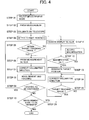
Fig. 4 is a flow chart to show operation of the embodiment of the invention; -
Fig. 5 is a flow chart to show operation of the embodiment of the invention; -
Fig. 6 (A) is a drawing of a display image to show a condition where it is collimated to the target, andFig. 6 (B) is a drawing of a display image to show a condition where the target is out of the tracking range; -
Fig. 7 is a drawing to explain another embodiment of the invention; and - In another embodiment of the invention,
Fig. 8 (A) shows a display image to show where a condition where the collimation is made to the target, andFig. 8 (B) is a drawing of a display image to show a condition where the target is out of the tracking range. - An embodiment comprises a surveying device and a remote control device provided on the side of the target. The surveying device is provided with the tracking function, and the surveying device and the remote control device can transmit and receive data to and from each other by communication means such as radio communication means.
- First, referring to
Fig. 1 ,asurveying system 1 is a total station. A pulsed laser beam is projected to a measuring point (target). By receiving a pulsed reflection light from the measuring point, the distance is measured for each pulse. The results of the distance measurement are averaged. As a result, the distance can be measured with high accuracy. - The
surveying device 1 primarily comprises aleveling unit 2 installed on a tripod (not shown), a base unit 3 mounted on theleveling unit 2, aframe unit 4 rotatably mounted on the base unit 3 around the vertical axis, and atelescope unit 5 rotatably mounted on theframe unit 4 around the horizontal axis. - The
frame unit 4 is provided with afirst display unit 6 and a firstoperation input unit 7. Thetelescope unit 5 has atelescope 8 for collimating the target and an image pickup unit 23 (to be described later) for acquiring an image in collimating direction via an optical system of thetelescope 8. A photodetection element, which is provided on the image pickup unit 23, is an assembly of pixels, for instance, CCD, CMOS, etc., and a position of each pixel, which receives the light, can be identified and a field angle can be obtained from the position of the pixel. Not only the image pickup unit 23 may be designed as a single photodetection element, but also a photodetection element for acquiring the image in the collimating direction and another photodetection element for tracking purpose may be separately provided. -
Fig. 2 shows a case where atarget 13 is mounted on an upper end of apole 14. Thetarget 13 is provided with a plurality ofprisms 15 so that tracking lights from thesurveying device 1 can be received from all circumferential directions and reflected. - The
remote control device 16 is mounted on thepole 14 via afixture 17, and a surveying operator can manipulate theremote control device 16 by a single hand when the operator is holding thepole 14. - The
remote control device 16 has asecond display unit 18 designed with a touch panel and a secondoperation input unit 20 or the like provided with anoperation button 19 or the like. Thesurveying device 1 and theremote control device 16 can transmit and receive data to and from each other by communication means such as radio communication means. - Now, referring to
Fig. 3 , description will be given on an approximate arrangement of the system. - First, the
surveying device 1 will be described. - The
telescope unit 5 is incorporated with a distance measuring unit 21 having a distance measuring light optical system, and the distance measuring unit 21 projects adistance measuring light 22 and receives a reflection light 22' from thetarget 13. Thus, an electro-optical (light wave) distance measurement to thetarget 13 can be carried out. Further, thetelescope unit 5 provides an image pickup unit 23 with an optical system, and the optical system is common with an optical system of the distance measuring light optical system. - The
frame unit 4 is provided with a horizontal drive unit 24 for rotating theframe unit 4 in horizontal direction. It is also provided with a horizontalangle measuring unit 25, which detects a horizontal rotation angle with respect to the base unit 3 on theframe unit 4 and also detects a horizontal angle in the collimating direction. Also, theframe unit 4 is provided with avertical drive unit 26 for rotating thetelescope unit 5 around the horizontal axis, and it is also provided with a verticalangle measuring unit 27, which detects a vertical angle of thetelescope unit 5 and measures a vertical angle in the collimating direction. The distance measuring unit 21, the horizontalangle measuring unit 25 and the verticalangle measuring unit 27 make up together a measuring unit. - The
frame unit 4 includes acontrol device 28. Thecontrol device 28 controls the driving of the horizontal drive unit 24 and of thevertical drive unit 26 and collimates thetelescope unit 5 in a predetermined direction by rotating theframe unit 4 and thetelescope unit 5, scans the light over a predetermined range, and switches over optical magnification of thetelescope 8, or acquires an image in the collimating direction by the image pickup unit 23. Further, thecontrol device 28 controls the changeover of electrically processed magnification of the acquired image, an image with the magnification as required is obtained. Also, thecontrol device 28 controls the distance measuring unit 21. Thus, a distance to thetarget 13 is measured. - The
control device 28 primarily comprises a first controlarithmetic unit 29, a distancemeasurement control unit 30, an imagepickup control unit 31, afirst storage unit 32, a first radio unit 33, afirst display unit 6, a firstoperation input unit 7, etc. - The results of measurement are inputted to the first control
arithmetic unit 29 from the distance measuring unit 21, the horizontalangle measuring unit 25, and the verticalangle measuring unit 27, and a distance, a horizontal angle and a vertical angle are measured respectively. The results of measurement are stored in thefirst storage unit 32 via the first controlarithmetic unit 29 and are displayed on thefirst display unit 6. - The
first storage unit 32 has a program storage area for storing different types of programs and a data storage area for storing data such as the measurement results. In the program storage area, various types of programs are stored. These programs include: a calculation program necessary for measurement, an image processing program for performing the image processing as to be described later, a prism measurement program for selecting measuring point from a processed image and for carrying out the distance measurement on the selected measuring point (target), a nonprism measurement program for carrying out measurement at a point other than the target, a measurement mode changeover program for realizing a measurement mode under the measuring condition suitable for the changed mode, a sequence program for tracking the measuring point, a search program for searching thetarget 13 when the measurement is started or when the target is missed, an image display program for displaying an image on thefirst display unit 6, and other programs. - The image
pickup control unit 31 controls the acquisition of an image by the image pickup unit 23 and processes the image data thus acquired. Also, the imagepickup control unit 31 can calculate a position of the target based on a photodetection signal from the photodetection element when the reflection light 22' enters the photodetection element of the image pickup unit 23. - The image
pickup control unit 31 can convert the photodetection signal from the photodetection element to a video signal and can display the image thus picked up on thefirst display unit 6 at real time. - The first radio unit 33 is designed to transmit measurement data such as a distance measurement data, angle measurement data, etc., and image data and video signal to the
remote control device 16, and it is also designed to receive an operation command from theremote control device 16. - Next, description will be given on the
remote control device 16. - The
remote control device 16 primarily comprises a second control arithmetic unit 35, a second storage unit 36, a second radio unit 37, asecond display unit 18, a secondoperation input unit 20, etc. - In the second storage unit 36, the following programs are stored: a communication program for performing radio communication with the
surveying device 1, a control command program for converging operation from the secondoperation input unit 20 or operation from the second display unit (touch panel) 18 to a control command signal and for transmitting the control command signal to thesurveying device 1 via the second radio unit 37, an image display program for displaying measurement data or a video signal from thesurveying device 1 on thesecond display unit 18, a coordinate position calculating program for calculating a position on thesecond display unit 18, and other programs. The second storage unit 36 has a data storage unit on a part of it, and measurement data and image data associated with the measurement data are stored in the data storage unit. If necessary, measurement schedule, measurement topographical data and measuring operation supplementary data such as measuring point are stored. When the operator calls via the secondoperation input unit 20, adequate operation supplementary information is displayed on thesecond display unit 18. - Now, referring to
Fig. 4 andFig. 5 , description will be given on operation. - The
target 13 is installed at the measuring point, and power is connected to thesurveying device 1. - (Step 1) As the initial setting after the connection of power, measurement mode is selected whether it is a prism measurement mode or a nonprism measurement mode. If the measurement mode is not set, it is made to automatic setting, e.g. to prism measurement mode (Step 02). Description will be given below on a case where it is first set to the prism measurement mode. In the initial condition, a scene (image data) taken by the image pickup unit 23 is displayed on the
first display unit 6. Video data is also transmitted to theremote control device 16, and the same scene is displayed on thesecond display unit 18. In some cases, the same scene is not displayed and measurement screen (such as measuring point information) may be displayed. In such case, the same scene can be displayed through input operation by the operator. - (Step 03) The
target 13 is collimated by thetelescope 8, and it is confirmed that thetarget 13 is within a range where can be tracked in the visual field of the telescope 8 (e.g. within a predetermined radius around the collimating point). Then, measurement and tracking are started.Fig. 6 shows initial screens. On the screens, the range where can be tracked is indicated by a dottedcircle 41 or the range is designated by a mark where the central portion of atarget line 42 is lacking. - (
Step 04 and Step 05) Based on an image signal from the image pickup unit 23, thetarget 13 is detected, and the field angle is determined from the position on the image of thetarget 13. From the field angle thus obtained, it is judged whether the direction of thetarget 13 is in the range where the target can be tracked. - (Step 06) If the target is within the range where can be tracked, at least the
second display unit 18 among thefirst display unit 6 and thesecond display unit 18 is changed to a prism measurement screen, and information relating to the measurement (measurement data) such as a measuring position, the distance measurement data, angle measurement data, etc. is displayed on thesecond display unit 18. - (Step 07) The collimating direction is corrected, and measurement and tracking are started.
- (Step 08) The target is tracked and the distance measurement and angle measurement are continuously carried out. The results of measurement are transmitted to the second radio unit 37 by the first radio unit 33 at real time, and the measurement data are stored on the second storage unit 36 and are displayed on the
second display unit 18. - (
Step 09 and Step 10) When a command to stop the tracking is issued from theremote control device 16, it is confirmed whether the change of the measurement mode to the nonprism measurement mode is required or not. If the change of the measurement mode is not needed, the measuring operation is terminated. - (Step 11) As the result of the detection of the position of the target in
Step 04, if the direction of thetarget 13 is out of the range where the target can be tracked or in a case where moving speed of the target exceeds the chasing speed of the surveying device and an obstacle intercepts the optical path of the collimating telescope under the condition of continuous tracking inStep 09 and automatic tracking is interrupted, the display screen is changed over. - When the display screen is changed over, a scene taken by the image pickup unit 23 is displayed on the
second display unit 18. Under the condition where the tracking is interrupted, the target is at a position deviated from the dottedcircle 41 as shown inFig.6 . - (Step 12) In case the
target 13 does not appear even when the display screen has been changed over, magnification of the display image is changed so that a scene in wider range can be displayed. To change the magnification, magnification of optical system may be changed or magnification may be electrically changed through data processing of image data. Or, the change of optical magnification and the change of magnification by data processing may be carried out at the same time. - The change of magnification may be made by operation of the surveying operator by operating a
button 43 for magnification change using a touch pen on thesecond display unit 18 or by transmitting a command for magnification change to thesurveying device 1. Or, if thetarget 13 cannot be detected in the image data through the image processing by the imagepickup control unit 31, it may be designed so that magnification can be automatically changed. - (Step 13) Wen the
target 13 has been confirmed in thesecond display unit 18, thetarget 13 on the image is touched by a touch pen. The touched position on thesecond display unit 18 is transmitted to the second control arithmetic unit 35. At the second control arithmetic unit 35, collimation center of the distance measuring unit 21 or deviation in the collimating direction from the dottedcircle 41 is calculated, and the result of calculation is sent to the first radio unit 33 via the second radio unit 37 as the collimating direction correcting data. - In case the
second display unit 18 is not designed as a touch panel, remote control in the collimating direction may be performed while watching the image from the secondoperation input unit 20. Button, pointing device (mouse), etc. are included in the secondoperation input unit 20. - (Step 14) The first control
arithmetic unit 29 receives deviation in the collimating direction via the first radio unit 33. Based on the deviation, the horizontal drive unit 24 and thevertical drive unit 26 are driven and the collimating direction of thetelescope 8 is corrected. - (Step 15) When it is judged that the target is located within the tracking range by the correction of the collimating direction, it is changed over to the prism measurement screen (Step 06), and measurement and tracking are continued.
- Next, description will be given on a case where a nonprism measurement is to be performed during the period when the prism measurement as described above is carried out.
- (Step 10) When a
mode changeover button 44 on thesecond display unit 18 of theremote control device 16 is operated by the touch panel, a prism measurement suspension command is issued and a measurement mode changing command is issued to thesurveying device 1. - (Step 25) The measurement mode is changed to the nonprism measurement mode.
- (
Step 26 and Step 27) A scene is displayed on thesecond display unit 18. Magnification of the display image is adjusted, and an image within the range necessary for the nonprism measurement is displayed. - (Step 28) A measuring position is designated by a touch pen on the
second display unit 18. The second control arithmetic unit 35 calculates deviation in the collimating direction from the designated measuring position and collimation center or from the dottedcircle 41, and the results of calculation are transmitted to the first radio unit 33 via the second radio unit 37. Based on the deviation thus transmitted, the first controlarithmetic unit 29 drives the horizontal drive unit 24 and thevertical drive unit 26, and thetelescope 8 is directed toward the designated point and the nonprism measurement is performed. The results of measurement are transmitted to theremote control device 16 from the first radio unit 33 and are displayed on thesecond display unit 18. When the results of measurement are to be stored, if the image at the nonprism measurement is associated with the measurement results and these are stored, it will be easier to identify the results of measurement subsequently. - In case it is to be returned to the prism measurement mode from the nonprism measurement mode, it is shifted to the prism measurement of
Step 02 by changing the mode after the measurement. In case the measurement is to be terminated from the nonprism measurement mode, the measurement operation is terminated by issuing a command not to change the mode. -
Fig. 7 andFig. 8 each represents a case where the present invention is applied to civil engineering work such as ground-leveling work using a construction machine, for instance, abulldozer 46 shown in the figure. - The
remote control device 16 is installed in a cabin of thebulldozer 46, and an operator can carry out the operation while recognizing information displayed by thesecond display unit 18, and it is so designed that a control command can be transmitted to thesurveying device 1 from theremote control device 16. - The
pole 14, which supports thetarget 13, is erected on a bulldozer blade (soil-pushing blade) 47. The distance between thetarget 13 and edge of thebulldozer blade 47 is already known. By tracking and measuring the position of thetarget 13, height of the edge of thebulldozer blade 47, i.e. height of the ground-leveling surface can be determined. - Construction working data (i.e. finishing data aimed by civil engineering work) are stored in the
first storage unit 32 or in the second storage unit 36 of thesurveying device 1. - The construction working data are displayed as adequately on the
second display unit 18, and the scene taken by the image pickup unit 23 is displayed in duplicated form on thesecond display unit 18. Further, the difference between the condition in the middle of working operation and the condition when the operation is completed can be confirmed by classifying the working data in different colors, and this contributes to the improvement of the working efficiency by the operator. When the operator selects the nonprism condition and designates a certain predetermined point in the surrounding on the image, the measurement result at that the predetermined point can be easily obtained, and the position of the operator and the conditions in the surrounding can be readily identified. -
Fig. 8 (A) shows a condition where thesurveying device 1 is collimated to the target 13 (the condition where tracking can be made), andFig. 8 (B) shows the condition where thesurveying device 1 misses thetarget 13.
Claims (7)
- A surveying system comprising a surveying device (1) provided with a function for tracking a target, and a remote control device (16) for remotely controlling said surveying device,
said surveying device comprising a measuring unit, an image pickup unit (23), a first radio unit (33), and a first control arithmetic unit (29);
said remote control device comprising a second radio unit (37), a second control arithmetic unit (35), a second display unit (18), and a second operation input unit (20);
wherein said first control arithmetic unit is operable to transmit measurement data of said measuring unit to said remote control device via said first radio unit when a detection result is within the tracking range based on the detection result of a reflection light from the target, and to transmit image data taken by said image pickup unit via said first radio unit when said detection result is out of the tracking range;
and wherein said second control arithmetic unit is operable to receive the measurement data and the image data via said second radio unit, and to display the measurement data or the image data on said second display unit. - A surveying system according to claim 1, wherein, under the condition when an image of said second display unit (18) is displayed, said second operation input unit (20)is configured to transmit correction data in the collimating direction to said surveying device (1) via said second radio unit (37) based on a display condition of the image, and wherein said first control arithmetic unit (29) is operable to receive the corrected data via said first radio unit (33), whereby the correction is made so that the collimating direction is within the tracking range.
- A surveying system according to claim 2, wherein said second display unit (18) has a touch panel with the function to operate as an operation unit, and the correction data of the collimating direction to direct the collimating direction toward the target, can be acquired by designating a position of the target (13) as displayed on said second display unit.
- A surveying system according to claim 1, wherein, when the target (13) is not displayed on said second display unit (18), a command for magnification change inputted from said second operation unit (20) is transmitted to said surveying device (1) and magnification of the image data acquired by said image pickup unit (23) can be changed.
- A surveying system according to claim 1, wherein said measuring unit has a prism measurement mode and in a nonprism measurement mode for distance measurement, an image taken by said image pickup unit (23) being displayed on said second display unit (18) in the nonprism measurement mode, and a distance to a designated position can be measured by designating a required position in the image.
- A surveying system according to claim 2, wherein the correction data of the collimating direction to direct the collimating direction toward the target can be acquired by designating the position of the target (13) displayed on said second display unit (18) by said second operation input unit (20).
- A surveying system according to claim 1, wherein said surveying device (1) further comprises an image pickup control unit (31), and said image pickup control unit is operable to change magnification of a display image when an image of the target is not detected within image data by an image processing.
Applications Claiming Priority (1)
| Application Number | Priority Date | Filing Date | Title |
|---|---|---|---|
| JP2007317155A JP5150229B2 (en) | 2007-12-07 | 2007-12-07 | Surveying system |
Publications (3)
| Publication Number | Publication Date |
|---|---|
| EP2068116A2 true EP2068116A2 (en) | 2009-06-10 |
| EP2068116A3 EP2068116A3 (en) | 2010-03-17 |
| EP2068116B1 EP2068116B1 (en) | 2011-10-26 |
Family
ID=40386303
Family Applications (1)
| Application Number | Title | Priority Date | Filing Date |
|---|---|---|---|
| EP08169861A Active EP2068116B1 (en) | 2007-12-07 | 2008-11-25 | Surveying system |
Country Status (6)
| Country | Link |
|---|---|
| US (1) | US7739803B2 (en) |
| EP (1) | EP2068116B1 (en) |
| JP (1) | JP5150229B2 (en) |
| CN (1) | CN101451836B (en) |
| AT (1) | ATE530875T1 (en) |
| AU (1) | AU2008249146B2 (en) |
Families Citing this family (16)
| Publication number | Priority date | Publication date | Assignee | Title |
|---|---|---|---|---|
| US7861424B2 (en) * | 2006-11-13 | 2011-01-04 | Robert Bosch Tool Corporation | Pipe laser |
| CN101680759B (en) * | 2007-05-30 | 2012-03-21 | 特林布尔公司 | Target for use in measuring and surveying applications |
| US8712721B2 (en) | 2010-07-08 | 2014-04-29 | Shayne Hamel | Adjustable high precision surveying device |
| JP5616174B2 (en) * | 2010-09-14 | 2014-10-29 | 株式会社トプコン | Laser surveying equipment |
| US9222771B2 (en) | 2011-10-17 | 2015-12-29 | Kla-Tencor Corp. | Acquisition of information for a construction site |
| US9001205B2 (en) * | 2011-10-20 | 2015-04-07 | Trimble Navigation Ltd. | System and methods for controlling a surveying device |
| US9279679B2 (en) * | 2012-09-12 | 2016-03-08 | Kabushiki Kaisha Topcon | Construction machine control method and construction machine control system |
| JP6253932B2 (en) * | 2013-09-17 | 2017-12-27 | 株式会社トプコン | Direction detection device and survey system |
| CN104807449A (en) * | 2015-04-29 | 2015-07-29 | 国家电网公司 | Power transmission line crossing measuring system based on stereo photogrammetry measurement |
| EP3176542A1 (en) * | 2015-12-01 | 2017-06-07 | Beamrider Limited | Odometer for a vehicle |
| JP6748916B2 (en) * | 2016-10-19 | 2020-09-02 | 清水建設株式会社 | ADJUSTING METHOD FOR REFLECTIVE TARGET AND ADJUSTING SYSTEM FOR REFLECTIVE TARGET |
| JP2018146407A (en) * | 2017-03-06 | 2018-09-20 | 株式会社トプコン | Acquisition method of rotation center of rotary member in construction work machine |
| WO2019014861A1 (en) * | 2017-07-18 | 2019-01-24 | Hangzhou Taruo Information Technology Co., Ltd. | Intelligent object tracking |
| GB2570910A (en) * | 2018-02-09 | 2019-08-14 | Hi Tec Security Systems Ltd | Method and system for targeting and tracking an intruder using a laser detection and ranging device |
| US11195324B1 (en) | 2018-08-14 | 2021-12-07 | Certainteed Llc | Systems and methods for visualization of building structures |
| WO2020140210A1 (en) | 2019-01-02 | 2020-07-09 | Hangzhou Taro Positioning Technology Co., Ltd. | Automated film-making using image-based object tracking |
Citations (4)
| Publication number | Priority date | Publication date | Assignee | Title |
|---|---|---|---|---|
| JPH07198383A (en) | 1993-12-28 | 1995-08-01 | Topcon Corp | Surveying instrument |
| JP2000346645A (en) | 1999-03-26 | 2000-12-15 | Topcon Corp | Surveying apparatus |
| EP1411371A1 (en) | 2002-10-18 | 2004-04-21 | Kabushiki Kaisha Topcon | Surveying and position measuring instrument with a fan-shapped light beam |
| JP2004170354A (en) | 2002-11-22 | 2004-06-17 | Topcon Corp | Automatic reflector tracking device |
Family Cites Families (25)
| Publication number | Priority date | Publication date | Assignee | Title |
|---|---|---|---|---|
| US4029415A (en) * | 1975-02-03 | 1977-06-14 | Dakota Electron, Inc. | Laser land-surveying apparatus with digital display |
| US4653910A (en) * | 1985-10-18 | 1987-03-31 | Spectra-Physics | Remote indicator for a laser alignment system |
| US4820041A (en) * | 1986-11-12 | 1989-04-11 | Agtek Development Co., Inc. | Position sensing system for surveying and grading |
| JPH0718703B2 (en) * | 1991-03-12 | 1995-03-06 | 東亜建設工業株式会社 | Three-dimensional surveying equipment |
| JP2946475B2 (en) * | 1991-06-27 | 1999-09-06 | 飛島建設株式会社 | Pile driving method |
| JPH05306907A (en) * | 1992-04-30 | 1993-11-19 | Suzuki Motor Corp | Lens measurement control system |
| JPH0694417A (en) * | 1992-09-09 | 1994-04-05 | Kobe Steel Ltd | Pointing device for spot light and measuring device for three-dimensional position |
| US5457890A (en) * | 1993-03-22 | 1995-10-17 | Mooty; Glenn J. | Scalable measuring apparatus and displacement display device, system and method |
| US5467290A (en) * | 1993-08-18 | 1995-11-14 | Atlantic Richfield Company | Survey system and method |
| JP3075384B2 (en) | 1993-09-16 | 2000-08-14 | 株式会社トプコン | Surveying equipment |
| JP3541960B2 (en) | 1993-12-24 | 2004-07-14 | 独立行政法人土木研究所 | Automatic 3D position control method for construction machinery |
| US5666792A (en) * | 1994-12-30 | 1997-09-16 | Mullins; Donald B. | Remotely guided brush cutting, chipping and clearing apparatus and method |
| US5671160A (en) * | 1995-06-05 | 1997-09-23 | Gcs Properties | Position sensing system |
| JP3741477B2 (en) * | 1996-03-18 | 2006-02-01 | 株式会社トプコン | Surveying system |
| US6014220A (en) | 1997-11-10 | 2000-01-11 | Kabushiki Kaisha Topcon | Automatic control system for construction machinery |
| JP3784154B2 (en) | 1997-11-14 | 2006-06-07 | 株式会社トプコン | Surveyor communication system |
| JP4175736B2 (en) * | 1999-05-13 | 2008-11-05 | フジノン株式会社 | Automatic tracking device for position measurement drawing |
| FR2812671B1 (en) * | 2000-08-01 | 2006-07-14 | Alstom | METHOD FOR GUIDING A DEVICE FOR INSERTING ELEMENTS IN THE SOIL FOR PRODUCING A WORK, AND DEVICE FOR INSERTING AT LEAST ONE ELEMENT IN THE SOIL USING SUCH A METHOD OF GUIDING |
| JP4356050B2 (en) * | 2000-12-28 | 2009-11-04 | 株式会社トプコン | Surveyor and electronic storage medium |
| JP2003139838A (en) | 2001-10-30 | 2003-05-14 | Mitsui & Co Ltd | Gps positioning system |
| JP2004093504A (en) * | 2002-09-03 | 2004-03-25 | Topcon Corp | Surveying device |
| JP2004333211A (en) * | 2003-05-01 | 2004-11-25 | Sokkia Co Ltd | Control unit of total station |
| US7168174B2 (en) * | 2005-03-14 | 2007-01-30 | Trimble Navigation Limited | Method and apparatus for machine element control |
| JP4971344B2 (en) | 2005-10-26 | 2012-07-11 | トリンブル イエナ ゲゼルシャフト ミット ベシュレンクテル ハフツング | Surveying method and surveying device |
| JP2008014658A (en) | 2006-07-03 | 2008-01-24 | Pentax Industrial Instruments Co Ltd | Surveying instrument |
-
2007
- 2007-12-07 JP JP2007317155A patent/JP5150229B2/en active Active
-
2008
- 2008-11-21 US US12/313,556 patent/US7739803B2/en active Active
- 2008-11-21 AU AU2008249146A patent/AU2008249146B2/en not_active Ceased
- 2008-11-25 EP EP08169861A patent/EP2068116B1/en active Active
- 2008-11-25 AT AT08169861T patent/ATE530875T1/en not_active IP Right Cessation
- 2008-12-05 CN CN2008101798174A patent/CN101451836B/en not_active Expired - Fee Related
Patent Citations (4)
| Publication number | Priority date | Publication date | Assignee | Title |
|---|---|---|---|---|
| JPH07198383A (en) | 1993-12-28 | 1995-08-01 | Topcon Corp | Surveying instrument |
| JP2000346645A (en) | 1999-03-26 | 2000-12-15 | Topcon Corp | Surveying apparatus |
| EP1411371A1 (en) | 2002-10-18 | 2004-04-21 | Kabushiki Kaisha Topcon | Surveying and position measuring instrument with a fan-shapped light beam |
| JP2004170354A (en) | 2002-11-22 | 2004-06-17 | Topcon Corp | Automatic reflector tracking device |
Also Published As
| Publication number | Publication date |
|---|---|
| CN101451836B (en) | 2012-04-25 |
| JP2009139277A (en) | 2009-06-25 |
| JP5150229B2 (en) | 2013-02-20 |
| AU2008249146B2 (en) | 2013-03-21 |
| ATE530875T1 (en) | 2011-11-15 |
| EP2068116A3 (en) | 2010-03-17 |
| EP2068116B1 (en) | 2011-10-26 |
| AU2008249146A1 (en) | 2009-06-25 |
| US20090144995A1 (en) | 2009-06-11 |
| CN101451836A (en) | 2009-06-10 |
| US7739803B2 (en) | 2010-06-22 |
Similar Documents
| Publication | Publication Date | Title |
|---|---|---|
| US7739803B2 (en) | Surveying system | |
| EP2141450B1 (en) | Surveying device and automatic tracking method | |
| US8310535B2 (en) | Surveying system | |
| US7701566B2 (en) | Surveying system | |
| EP3677872B1 (en) | Surveying instrument | |
| US11822351B2 (en) | Three-dimensional information processing unit, apparatus having three-dimensional information processing unit, unmanned aerial vehicle, informing device, method and program for controlling mobile body using three-dimensional information processing unit | |
| US8184267B2 (en) | Surveying instrument | |
| US20170082748A1 (en) | Polygon mirror, fan beam output device, and survey system | |
| EP2863173B1 (en) | Measuring method and measuring instrument | |
| CN101852857B (en) | Surveying device and automatic tracking method | |
| US9932719B2 (en) | Control system for construction machine | |
| US20210025707A1 (en) | Surveying System | |
| JP2021067615A (en) | Scanner system and scan method | |
| JP2022173672A (en) | surveying system |
Legal Events
| Date | Code | Title | Description |
|---|---|---|---|
| PUAI | Public reference made under article 153(3) epc to a published international application that has entered the european phase |
Free format text: ORIGINAL CODE: 0009012 |
|
| AK | Designated contracting states |
Kind code of ref document: A2 Designated state(s): AT BE BG CH CY CZ DE DK EE ES FI FR GB GR HR HU IE IS IT LI LT LU LV MC MT NL NO PL PT RO SE SI SK TR |
|
| AX | Request for extension of the european patent |
Extension state: AL BA MK RS |
|
| PUAL | Search report despatched |
Free format text: ORIGINAL CODE: 0009013 |
|
| AK | Designated contracting states |
Kind code of ref document: A3 Designated state(s): AT BE BG CH CY CZ DE DK EE ES FI FR GB GR HR HU IE IS IT LI LT LU LV MC MT NL NO PL PT RO SE SI SK TR |
|
| AX | Request for extension of the european patent |
Extension state: AL BA MK RS |
|
| 17P | Request for examination filed |
Effective date: 20100525 |
|
| AKX | Designation fees paid |
Designated state(s): AT BE BG CH CY CZ DE DK EE ES FI FR GB GR HR HU IE IS IT LI LT LU LV MC MT NL NO PL PT RO SE SI SK TR |
|
| GRAP | Despatch of communication of intention to grant a patent |
Free format text: ORIGINAL CODE: EPIDOSNIGR1 |
|
| RIC1 | Information provided on ipc code assigned before grant |
Ipc: G01C 15/00 20060101AFI20110429BHEP Ipc: G01S 17/02 20060101ALI20110429BHEP |
|
| GRAS | Grant fee paid |
Free format text: ORIGINAL CODE: EPIDOSNIGR3 |
|
| GRAA | (expected) grant |
Free format text: ORIGINAL CODE: 0009210 |
|
| AK | Designated contracting states |
Kind code of ref document: B1 Designated state(s): AT BE BG CH CY CZ DE DK EE ES FI FR GB GR HR HU IE IS IT LI LT LU LV MC MT NL NO PL PT RO SE SI SK TR |
|
| REG | Reference to a national code |
Ref country code: GB Ref legal event code: FG4D |
|
| REG | Reference to a national code |
Ref country code: CH Ref legal event code: NV Representative=s name: FIAMMENGHI-FIAMMENGHI Ref country code: CH Ref legal event code: EP |
|
| REG | Reference to a national code |
Ref country code: IE Ref legal event code: FG4D |
|
| REG | Reference to a national code |
Ref country code: DE Ref legal event code: R096 Ref document number: 602008010791 Country of ref document: DE Effective date: 20120105 |
|
| REG | Reference to a national code |
Ref country code: SE Ref legal event code: TRGR |
|
| REG | Reference to a national code |
Ref country code: NL Ref legal event code: VDEP Effective date: 20111026 |
|
| LTIE | Lt: invalidation of european patent or patent extension |
Effective date: 20111026 |
|
| REG | Reference to a national code |
Ref country code: AT Ref legal event code: MK05 Ref document number: 530875 Country of ref document: AT Kind code of ref document: T Effective date: 20111026 |
|
| PG25 | Lapsed in a contracting state [announced via postgrant information from national office to epo] |
Ref country code: LT Free format text: LAPSE BECAUSE OF FAILURE TO SUBMIT A TRANSLATION OF THE DESCRIPTION OR TO PAY THE FEE WITHIN THE PRESCRIBED TIME-LIMIT Effective date: 20111026 Ref country code: BE Free format text: LAPSE BECAUSE OF FAILURE TO SUBMIT A TRANSLATION OF THE DESCRIPTION OR TO PAY THE FEE WITHIN THE PRESCRIBED TIME-LIMIT Effective date: 20111026 Ref country code: NO Free format text: LAPSE BECAUSE OF FAILURE TO SUBMIT A TRANSLATION OF THE DESCRIPTION OR TO PAY THE FEE WITHIN THE PRESCRIBED TIME-LIMIT Effective date: 20120126 Ref country code: IS Free format text: LAPSE BECAUSE OF FAILURE TO SUBMIT A TRANSLATION OF THE DESCRIPTION OR TO PAY THE FEE WITHIN THE PRESCRIBED TIME-LIMIT Effective date: 20120226 |
|
| PG25 | Lapsed in a contracting state [announced via postgrant information from national office to epo] |
Ref country code: HR Free format text: LAPSE BECAUSE OF FAILURE TO SUBMIT A TRANSLATION OF THE DESCRIPTION OR TO PAY THE FEE WITHIN THE PRESCRIBED TIME-LIMIT Effective date: 20111026 Ref country code: GR Free format text: LAPSE BECAUSE OF FAILURE TO SUBMIT A TRANSLATION OF THE DESCRIPTION OR TO PAY THE FEE WITHIN THE PRESCRIBED TIME-LIMIT Effective date: 20120127 Ref country code: NL Free format text: LAPSE BECAUSE OF FAILURE TO SUBMIT A TRANSLATION OF THE DESCRIPTION OR TO PAY THE FEE WITHIN THE PRESCRIBED TIME-LIMIT Effective date: 20111026 Ref country code: PL Free format text: LAPSE BECAUSE OF FAILURE TO SUBMIT A TRANSLATION OF THE DESCRIPTION OR TO PAY THE FEE WITHIN THE PRESCRIBED TIME-LIMIT Effective date: 20111026 Ref country code: PT Free format text: LAPSE BECAUSE OF FAILURE TO SUBMIT A TRANSLATION OF THE DESCRIPTION OR TO PAY THE FEE WITHIN THE PRESCRIBED TIME-LIMIT Effective date: 20120227 Ref country code: SI Free format text: LAPSE BECAUSE OF FAILURE TO SUBMIT A TRANSLATION OF THE DESCRIPTION OR TO PAY THE FEE WITHIN THE PRESCRIBED TIME-LIMIT Effective date: 20111026 Ref country code: LV Free format text: LAPSE BECAUSE OF FAILURE TO SUBMIT A TRANSLATION OF THE DESCRIPTION OR TO PAY THE FEE WITHIN THE PRESCRIBED TIME-LIMIT Effective date: 20111026 |
|
| PG25 | Lapsed in a contracting state [announced via postgrant information from national office to epo] |
Ref country code: MC Free format text: LAPSE BECAUSE OF NON-PAYMENT OF DUE FEES Effective date: 20111130 Ref country code: CY Free format text: LAPSE BECAUSE OF FAILURE TO SUBMIT A TRANSLATION OF THE DESCRIPTION OR TO PAY THE FEE WITHIN THE PRESCRIBED TIME-LIMIT Effective date: 20111026 |
|
| PG25 | Lapsed in a contracting state [announced via postgrant information from national office to epo] |
Ref country code: BG Free format text: LAPSE BECAUSE OF FAILURE TO SUBMIT A TRANSLATION OF THE DESCRIPTION OR TO PAY THE FEE WITHIN THE PRESCRIBED TIME-LIMIT Effective date: 20120126 Ref country code: DK Free format text: LAPSE BECAUSE OF FAILURE TO SUBMIT A TRANSLATION OF THE DESCRIPTION OR TO PAY THE FEE WITHIN THE PRESCRIBED TIME-LIMIT Effective date: 20111026 Ref country code: CZ Free format text: LAPSE BECAUSE OF FAILURE TO SUBMIT A TRANSLATION OF THE DESCRIPTION OR TO PAY THE FEE WITHIN THE PRESCRIBED TIME-LIMIT Effective date: 20111026 Ref country code: EE Free format text: LAPSE BECAUSE OF FAILURE TO SUBMIT A TRANSLATION OF THE DESCRIPTION OR TO PAY THE FEE WITHIN THE PRESCRIBED TIME-LIMIT Effective date: 20111026 Ref country code: SK Free format text: LAPSE BECAUSE OF FAILURE TO SUBMIT A TRANSLATION OF THE DESCRIPTION OR TO PAY THE FEE WITHIN THE PRESCRIBED TIME-LIMIT Effective date: 20111026 |
|
| REG | Reference to a national code |
Ref country code: IE Ref legal event code: MM4A |
|
| PG25 | Lapsed in a contracting state [announced via postgrant information from national office to epo] |
Ref country code: RO Free format text: LAPSE BECAUSE OF FAILURE TO SUBMIT A TRANSLATION OF THE DESCRIPTION OR TO PAY THE FEE WITHIN THE PRESCRIBED TIME-LIMIT Effective date: 20111026 |
|
| PLBE | No opposition filed within time limit |
Free format text: ORIGINAL CODE: 0009261 |
|
| STAA | Information on the status of an ep patent application or granted ep patent |
Free format text: STATUS: NO OPPOSITION FILED WITHIN TIME LIMIT |
|
| REG | Reference to a national code |
Ref country code: FR Ref legal event code: ST Effective date: 20120817 |
|
| 26N | No opposition filed |
Effective date: 20120727 |
|
| PG25 | Lapsed in a contracting state [announced via postgrant information from national office to epo] |
Ref country code: IE Free format text: LAPSE BECAUSE OF NON-PAYMENT OF DUE FEES Effective date: 20111125 |
|
| REG | Reference to a national code |
Ref country code: DE Ref legal event code: R097 Ref document number: 602008010791 Country of ref document: DE Effective date: 20120727 |
|
| PG25 | Lapsed in a contracting state [announced via postgrant information from national office to epo] |
Ref country code: AT Free format text: LAPSE BECAUSE OF FAILURE TO SUBMIT A TRANSLATION OF THE DESCRIPTION OR TO PAY THE FEE WITHIN THE PRESCRIBED TIME-LIMIT Effective date: 20111026 |
|
| PG25 | Lapsed in a contracting state [announced via postgrant information from national office to epo] |
Ref country code: MT Free format text: LAPSE BECAUSE OF FAILURE TO SUBMIT A TRANSLATION OF THE DESCRIPTION OR TO PAY THE FEE WITHIN THE PRESCRIBED TIME-LIMIT Effective date: 20111026 |
|
| PG25 | Lapsed in a contracting state [announced via postgrant information from national office to epo] |
Ref country code: FR Free format text: LAPSE BECAUSE OF NON-PAYMENT OF DUE FEES Effective date: 20111226 |
|
| PG25 | Lapsed in a contracting state [announced via postgrant information from national office to epo] |
Ref country code: LU Free format text: LAPSE BECAUSE OF NON-PAYMENT OF DUE FEES Effective date: 20111125 |
|
| PG25 | Lapsed in a contracting state [announced via postgrant information from national office to epo] |
Ref country code: FI Free format text: LAPSE BECAUSE OF FAILURE TO SUBMIT A TRANSLATION OF THE DESCRIPTION OR TO PAY THE FEE WITHIN THE PRESCRIBED TIME-LIMIT Effective date: 20111026 |
|
| PG25 | Lapsed in a contracting state [announced via postgrant information from national office to epo] |
Ref country code: TR Free format text: LAPSE BECAUSE OF FAILURE TO SUBMIT A TRANSLATION OF THE DESCRIPTION OR TO PAY THE FEE WITHIN THE PRESCRIBED TIME-LIMIT Effective date: 20111026 |
|
| PG25 | Lapsed in a contracting state [announced via postgrant information from national office to epo] |
Ref country code: ES Free format text: LAPSE BECAUSE OF FAILURE TO SUBMIT A TRANSLATION OF THE DESCRIPTION OR TO PAY THE FEE WITHIN THE PRESCRIBED TIME-LIMIT Effective date: 20120206 Ref country code: HU Free format text: LAPSE BECAUSE OF FAILURE TO SUBMIT A TRANSLATION OF THE DESCRIPTION OR TO PAY THE FEE WITHIN THE PRESCRIBED TIME-LIMIT Effective date: 20111026 |
|
| PGFP | Annual fee paid to national office [announced via postgrant information from national office to epo] |
Ref country code: IT Payment date: 20151124 Year of fee payment: 8 Ref country code: GB Payment date: 20151125 Year of fee payment: 8 |
|
| PGFP | Annual fee paid to national office [announced via postgrant information from national office to epo] |
Ref country code: SE Payment date: 20151111 Year of fee payment: 8 |
|
| REG | Reference to a national code |
Ref country code: SE Ref legal event code: EUG |
|
| GBPC | Gb: european patent ceased through non-payment of renewal fee |
Effective date: 20161125 |
|
| PG25 | Lapsed in a contracting state [announced via postgrant information from national office to epo] |
Ref country code: SE Free format text: LAPSE BECAUSE OF NON-PAYMENT OF DUE FEES Effective date: 20161126 |
|
| PG25 | Lapsed in a contracting state [announced via postgrant information from national office to epo] |
Ref country code: IT Free format text: LAPSE BECAUSE OF NON-PAYMENT OF DUE FEES Effective date: 20161125 |
|
| PG25 | Lapsed in a contracting state [announced via postgrant information from national office to epo] |
Ref country code: GB Free format text: LAPSE BECAUSE OF NON-PAYMENT OF DUE FEES Effective date: 20161125 |
|
| REG | Reference to a national code |
Ref country code: DE Ref legal event code: R082 Ref document number: 602008010791 Country of ref document: DE Representative=s name: SCHIWECK WEINZIERL KOCH PATENTANWAELTE PARTNER, DE |
|
| PGFP | Annual fee paid to national office [announced via postgrant information from national office to epo] |
Ref country code: DE Payment date: 20230929 Year of fee payment: 16 Ref country code: CH Payment date: 20231202 Year of fee payment: 16 |