EP1840518A2 - Navigation system - Google Patents
Navigation system Download PDFInfo
- Publication number
- EP1840518A2 EP1840518A2 EP07005806A EP07005806A EP1840518A2 EP 1840518 A2 EP1840518 A2 EP 1840518A2 EP 07005806 A EP07005806 A EP 07005806A EP 07005806 A EP07005806 A EP 07005806A EP 1840518 A2 EP1840518 A2 EP 1840518A2
- Authority
- EP
- European Patent Office
- Prior art keywords
- information
- travel time
- congested section
- navigation apparatus
- vehicle position
- Prior art date
- Legal status (The legal status is an assumption and is not a legal conclusion. Google has not performed a legal analysis and makes no representation as to the accuracy of the status listed.)
- Withdrawn
Links
- 238000012545 processing Methods 0.000 description 18
- 238000000034 method Methods 0.000 description 16
- 238000004364 calculation method Methods 0.000 description 13
- 238000010586 diagram Methods 0.000 description 12
- 238000012546 transfer Methods 0.000 description 12
- 238000004891 communication Methods 0.000 description 11
- 238000013500 data storage Methods 0.000 description 6
- 238000006243 chemical reaction Methods 0.000 description 4
- 230000015654 memory Effects 0.000 description 4
- 238000009435 building construction Methods 0.000 description 3
- 238000010276 construction Methods 0.000 description 3
- 230000003287 optical effect Effects 0.000 description 3
- 230000001133 acceleration Effects 0.000 description 2
- 238000001514 detection method Methods 0.000 description 2
- 230000008520 organization Effects 0.000 description 2
- 102220103881 rs201490575 Human genes 0.000 description 2
- 230000003936 working memory Effects 0.000 description 2
- 206010039203 Road traffic accident Diseases 0.000 description 1
- 230000001419 dependent effect Effects 0.000 description 1
- 238000011161 development Methods 0.000 description 1
- 230000018109 developmental process Effects 0.000 description 1
- 230000000694 effects Effects 0.000 description 1
- 238000003825 pressing Methods 0.000 description 1
- 230000004044 response Effects 0.000 description 1
- 239000004065 semiconductor Substances 0.000 description 1
Images



Classifications
-
- G—PHYSICS
- G01—MEASURING; TESTING
- G01C—MEASURING DISTANCES, LEVELS OR BEARINGS; SURVEYING; NAVIGATION; GYROSCOPIC INSTRUMENTS; PHOTOGRAMMETRY OR VIDEOGRAMMETRY
- G01C21/00—Navigation; Navigational instruments not provided for in groups G01C1/00 - G01C19/00
- G01C21/26—Navigation; Navigational instruments not provided for in groups G01C1/00 - G01C19/00 specially adapted for navigation in a road network
- G01C21/34—Route searching; Route guidance
- G01C21/36—Input/output arrangements for on-board computers
- G01C21/3691—Retrieval, searching and output of information related to real-time traffic, weather, or environmental conditions
-
- G—PHYSICS
- G08—SIGNALLING
- G08G—TRAFFIC CONTROL SYSTEMS
- G08G1/00—Traffic control systems for road vehicles
- G08G1/01—Detecting movement of traffic to be counted or controlled
- G08G1/0104—Measuring and analyzing of parameters relative to traffic conditions
-
- G—PHYSICS
- G08—SIGNALLING
- G08G—TRAFFIC CONTROL SYSTEMS
- G08G1/00—Traffic control systems for road vehicles
- G08G1/09—Arrangements for giving variable traffic instructions
- G08G1/0962—Arrangements for giving variable traffic instructions having an indicator mounted inside the vehicle, e.g. giving voice messages
- G08G1/0968—Systems involving transmission of navigation instructions to the vehicle
- G08G1/096805—Systems involving transmission of navigation instructions to the vehicle where the transmitted instructions are used to compute a route
- G08G1/096827—Systems involving transmission of navigation instructions to the vehicle where the transmitted instructions are used to compute a route where the route is computed onboard
-
- G—PHYSICS
- G08—SIGNALLING
- G08G—TRAFFIC CONTROL SYSTEMS
- G08G1/00—Traffic control systems for road vehicles
- G08G1/09—Arrangements for giving variable traffic instructions
- G08G1/0962—Arrangements for giving variable traffic instructions having an indicator mounted inside the vehicle, e.g. giving voice messages
- G08G1/0968—Systems involving transmission of navigation instructions to the vehicle
- G08G1/096833—Systems involving transmission of navigation instructions to the vehicle where different aspects are considered when computing the route
- G08G1/096844—Systems involving transmission of navigation instructions to the vehicle where different aspects are considered when computing the route where the complete route is dynamically recomputed based on new data
Definitions
- the present invention relates to a navigation system particularly for distributing a congested section travel time required to travel a congested section from an information distribution center to a navigation apparatus.
- a navigation apparatus for enabling a driver to easily navigate a vehicle to a desired destination has become very popular.
- the navigation apparatus detects a current position of the vehicle, for example, by a GPS receiver, obtains map data corresponding to the current position through a data storage medium such as a DVD-ROM or an HDD, or a network, and displays the map on an LCD monitor.
- the navigation apparatus reads out map data including a current position of the vehicle from the data storage medium, draws and displays the map surrounding the current vehicle position on a display device on the basis of the map data.
- the navigation apparatus further indicates the position of the vehicle on the map using a position indicator.
- the map may be scrolled according to the traveling direction of the vehicle or the vehicle position indicator may be relocated over the fixed map, so that the driver may check where the vehicle is currently traveling at a glance.
- a navigation system (as disclosed, for example, in Japanese Unexamined Patent Application Publication No. 2004-20288 (paragraph 0011 to paragraph 0039, FIGs. 1 to 6)) comprises a navigation apparatus and an information distribution center, the navigation apparatus including position detecting means for detecting a position of a vehicle and outputting position information, a map information database for storing map information including information about preset road sections, required travel time reporting means for calculating a time required to pass through the road section whenever traveling along the road section and reporting the required travel time to the information distribution center, required time querying means for querying a latest required travel time for a road section, on which the vehicle will be traveling, to the information distribution center, arrival time predicting means for predicting an arrival time to a destination on the basis of the latest time required to travel the road section on which the vehicle will be traveling received from the information distribution center, and transferring means for communicating with the information distribution center, and the information distribution center including a receiving section for receiving required section travel time information reported from the vehicle, a required section travel time database for
- the information distribution center stores the latest required travel times of road sections reported from vehicles in a database.
- the navigation system in the vehicle queries and obtains the latest travel time of a road section on which the vehicle is currently traveling to the information distribution center and predicts the arrival time to the destination on the basis of the latest travel time for the road section.
- the navigation system may predict the arrival time to the destination quite accurately according to the traffic congestion situation at a given time even if a traffic analysis apparatus is not set on the road section.
- the navigation apparatus calculates a required time to travel a road section every time the navigation apparatus passes through the road section and reports the required time to the information distribution center. For example, when it takes a long time for a vehicle with the navigation system to travel through a congested section (for example, about 30 minutes to 3 hours), the information distribution center has to wait a long time until it receives the required time to travel the congested section (a congested section travel time), so that the information distribution center cannot distribute the congested section travel time to another navigation apparatus of a vehicle which is not traveling in the congested section.
- a congested section travel time for example, about 30 minutes to 3 hours
- the navigation apparatus is adapted for transferring vehicle position to the information distribution center at predetermined time intervals (for example, at about 30 seconds intervals) and the information distribution center is adapted for calculating a required time to travel the congested section (a congested section travel time) before the navigation apparatus passes through the congested section and distributing the congested section travel time to the navigation apparatus and/or another navigation apparatus which is not currently traveling on the congested section.
- a navigation system (1) comprising a navigation apparatus (2), and an information distribution center (3) for distributing information (data) on a section travel time necessary for passing through a road section
- the navigation apparatus (2) includes a vehicle position information transferring device (27) for transferring a piece of vehicle position information including vehicle position and passing time when the navigation apparatus passes through the vehicle position to the information distribution center at predetermined time intervals, which is called a first time interval
- the information distribution center (3) includes a vehicle position information receiving device (17) for receiving vehicle position information, a vehicle position information storage device (12) for storing received vehicle position information in order of arrival, a traffic information receiving device (17) for receiving traffic information including congestion information, a congested section specifying device (11) for specifying a congested section on the basis of congestion information, a first calculating device (11) for classifying the weight of a first travel distance within the congested section which is calculated on the basis of two pieces of vehicle position information received from the navigation apparatus (2) associating with congestion information about
- the navigation apparatus transfers vehicle position information which includes vehicle position and passing time when the navigation apparatus passes through the vehicle position to the information distribution center at predetermined time intervals, which is a first time period interval.
- the information distribution center calculates a first travel distance within the congested section on the basis of the two pieces of vehicle position information received from the navigation apparatus.
- the information distribution center classifies the weight of the first travel distance associating with congestion information about the congested section and calculates a first travel time corresponding to the first travel distance.
- the information distribution center further calculates a congested section travel time necessary for passing through the congested section on the basis of the first travel time and distributes the congested section travel time to the navigation apparatus.
- the navigation apparatus transfers vehicle position information to the information distribution center at the first time period intervals (for example, at about 30 seconds intervals), so that the information distribution center may calculate the congested section travel time necessary for passing through the congested section on the basis of the two pieces of vehicle position information obtained at the first time period intervals and distribute the congested section travel time to another navigation apparatus which is not currently traveling the congested section.
- the navigation apparatus which is currently traveling the congested section may obtain the congested section travel time necessary for passing through the congested section from the information distribution center during traveling within the congested section, so that it may be possible to predict a quite accurate arrival time to a destination on the basis of the latest predicted travel time necessary for passing through the congested section.
- the information distribution center may be additionally or alternatively adapted to calculate a first travel distance within the congested section on the basis of the two pieces of vehicle position information, when one is received from the navigation apparatus before the navigation apparatus enters the congested section and the other is received from the navigation apparatus when the navigation apparatus is located within the congested section.
- the information distribution center may be additionally or alternatively adapted to classify the weight of the first travel distance associating with congestion information about the congested section and calculates a first travel time corresponding to the first travel distance.
- the information distribution center may be additionally or alternatively adapted to further calculate the congested section travel time necessary for passing through the congested section on the basis of the first travel time and to distribute the congested section travel time to the navigation apparatus.
- the information distribution center may calculate the congested section travel time necessary for passing through the congested section on the basis of the two pieces of vehicle position information, one is received from the navigation apparatus before the navigation apparatus enters the congested section and the other is received from the navigation apparatus when the navigation apparatus is located within the congested section, at the first time period intervals, and distribute the congested section travel time to another navigation apparatus which is not currently traveling the congested section.
- the navigation apparatus which is currently traveling the congested section may obtain the congested section travel time necessary for passing through the congested section from the information distribution center during traveling within the congested section, so that it may be possible to predict a quite accurate arrival time to a destination on the basis of the latest predicted travel time necessary for passing through the congested section.
- the information distribution center may be additionally or alternatively adapted to calculate a second travel time by adding the first time period to the first travel time necessary for traveling the first travel distance within the congested section every time the vehicle position information is received, and to calculate the congested section travel time necessary for passing through the congested section on the basis of the second travel time.
- the information distribution center may recalculate the congested section travel time.
- the congested section travel time necessary for passing through the congested section may be updated and it may be possible to distribute a quite accurate congested section travel time to another navigation apparatus which is not currently traveling the congested section.
- the navigation apparatus which is currently traveling the congested section may obtain the congested section travel time which is updated at the first time period intervals from the information distribution center, so that it may be possible to predict a quite accurate arrival time to a destination on the basis of the latest predicted travel time necessary for passing through the congested section.
- the information distribution center may be additionally or alternatively adapted to calculate a third travel time for a second travel distance which is the required time to travel from "vehicle position" to a point where the navigation apparatus passes through the congested section.
- the vehicle position here is the point where the navigation apparatus received vehicle position information within the congested section for last and the position is defined on the basis of both pieces of vehicle position information, one is received within the congested section for last and the other is received after the navigation apparatus passed through the congested section.
- the information distribution center may be additionally or alternatively adapted to classify the weight of the second travel distance associating with the congested section and calculates the third travel time corresponding to the second travel distance.
- the information distribution center distributes the sum of the first or second travel time (depending on whether there was a previous piece of vehicle information for a travel distance completely located within the congested section or not) and the third travel time as a forth travel time, which is the congested section travel time necessary for passing through the congested section, to the navigation apparatus.
- the information distribution center may be additionally or alternatively adapted to calculate the first travel distance within the congested section on the basis of the two pieces of vehicle position information, one is received from a navigation apparatus before the navigation apparatus enters the congested section and the other is received from the navigation apparatus after the navigation apparatus passes through the congested section.
- the information distribution center may be additionally or alternatively adapted to classify the weight of the first travel distance associating with congested information of the congested section and calculates a first travel time corresponding to the first travel distance on the basis of the first time which is the time when the two pieces of vehicle position information is received. More specifically, the congested section travel time necessary for passing through the congested section is calculated and distributed to the navigation apparatus.
- the information distribution center may calculate the congested section travel time necessary for passing through the congested section on the basis of the two pieces of vehicle position information, one is received from the navigation apparatus before the navigation apparatus enters the congested section and the other is received from the navigation apparatus after the navigation apparatus passed through the congested section, and distribute the congested section travel time to another navigation apparatus which is not currently traveling the congested section.
- the information distribution center distributes the congested section travel time to the navigation apparatus when the information distribution center receives a request to distribute the congested section travel time from the navigation apparatus. Therefore, the navigation apparatus may obtain the latest congested section travel time from the information distribution center when needed and predict a quite accurate arrival time to a destination.
- the information distribution center distributes a congested section travel time to the navigation apparatus at the second time period intervals (for example, at about 5 through 10 minutes intervals). Therefore, the navigation apparatus may obtain the latest congested section travel time from the information distribution center at the second time period intervals and predict a quite accurate arrival time to a destination.
- the information distribution center distributes the congested section travel time to the navigation apparatus every time the congested section travel time is updated. Therefore, the navigation apparatus may obtain the latest congested section travel time from the information distribution center at the first time period intervals and predict a quite accurate arrival time to a destination.
- FIG. 1 is a block diagram showing a navigation system according to the current embodiment of the invention.
- FIG. 2 is a block diagram showing a navigation apparatus in the navigation system.
- FIG. 3 is a flowchart showing "vehicle position information transferring processing” executed by the navigation apparatus in the navigation system and "congested section travel time distributing processing” executed by an information distribution center.
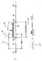
- FIG. 4 is a diagram showing a procedure of Step 112 in FIG. 3 and showing a calculation of a congested section travel time on the basis of both pieces of vehicle position information; one is received from the navigation apparatus at a point A before the navigation apparatus enters the congested section and the other is received from the navigation apparatus at a point B when the navigation apparatus is located within the congested section.
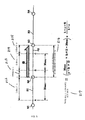
- FIG. 5 is the continuation of FIG. 4 and is a diagram showing the calculation of the congested section travel time on the basis of vehicle position information which is received from the navigation apparatus at a point C within the congested section, the information is the second information transferred from the navigation apparatus within the congested section.
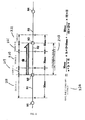
- FIG. 6 is the rest of FIG. 5 and is a diagram showing the calculation of the congested section travel time on the basis of vehicle position information received from the navigation apparatus at a point D where the navigation apparatus passed through the congested section.
- FIG. 7 is a diagram showing a procedure of Step 112 in FIG. 3 and showing the calculation of the congested section travel time on the basis of both pieces of vehicle position information; one is received from the navigation apparatus at the point A before the navigation apparatus enters the congested section and the other is received at the point D where the navigation apparatus passes through the congested section.
- FIG. 1 is a block diagram showing the navigation system 1 according to the current embodiment.
- the navigation system 1 basically includes a navigation apparatus 2, an information distribution center 3 for distributing update information which the navigation apparatus 2 needs to update map information and/or a congested section travel time necessary for passing through a congested section (described later), and a network 4.
- the navigation apparatus 2 and the information distribution center 3 may transfer various types of information through the network 4.
- a road traffic information center (VICS ®: Vehicle Information and Communication System) 5 is connected to the network 4, and the navigation apparatus 2 and the information distribution center 3 may receive traffic information such as road congestion information and/or traffic control information, both types of information are created by collecting information from a traffic control system shared by the Police Department and the Japan Highway Public Corporation, at predetermined time intervals through the network 4. For example, detailed traffic information such as road congestion information according to road congestion and/or traffic control information according to road construction and/or building construction may be included.
- VICS link ID (described later), length of an actual congested section, congestion degree (not congested/crowded/congested), vehicle speed in a congested section, travel direction of traffic in a congested traffic lane, and predicted time for reduction of congestion may be included.
- traffic control information a traffic type or traffic control period information such as the VICS link ID (described later), a construction period of road construction/building construction, a closed-section-to-traffic road, an alternate one-way traffic control, and/or a lane closure may be included. Note that, a structure of the navigation apparatus 2 will be described later with reference to FIG. 2.
- the information distribution center 3 includes a server 10, a center map information DB 14 as a map information storage section connected to the server 10, a navigation update history information DB 15, a center traffic information DB 16, a center communication device 17, and a section travel time DB 20 for storing a travel time necessary for passing through a road section (a road link).
- the server 10 may include an internal storage device such as a CPU 11, an RAM 12, and/or an ROM 13.
- the CPU 11 is a calculating device and a control device for controlling the entire server 10.
- the RAM 12 is used as a working memory when the CPU 11 executes various calculations.
- various types of control programs (FIG. 3) such as map information update processing and congested section travel time distributing processing are stored.
- the information distribution center 3 abstracts update information for updating map information to new map information according to a certain section among sections included in map information stored in the navigation apparatus 2 from the center map information DB 14 on the basis of a request from the navigation apparatus 2 and distributes the new map information to the navigation apparatus 2.
- the information distribution center 3 updates and stores a congested section travel time necessary for passing through a congested section (described later) in a section travel time DB 20, reads out the congested section travel time from the section travel time DB 20 on the basis of the request from the navigation apparatus 2, and distributes the congested section travel time to the navigation apparatus 2.
- an MPU may be used instead of the CPU 11.
- Update map information 18 is sorted into versions and is stored in the center map information DB 14, so that the update map information 18 forms the basis of map information crested in the information distribution center 3 and stored in a navigation apparatus 2. Further, update information for updating a part of or the entire map information which is currently stored in the navigation apparatus 2 to the update map information 18 is also stored in the center map information DB 14.
- "Version" here refers to a creation date specifying when map information is created.
- map display data for displaying a map, intersection data, node data for node points, link data for roads (road links) as a type of facility, search data for searching for a route, shop data for POI (point of interest) as a type of facility, and/or detection data for detecting points may be included in the update map information 18.
- the second mesh which divides the land into 10-square-kilometer areas is used as a standard unit.
- the standard unit may be subdivided into 4 subunits (1/2 length), 16 subunits (1/4 length), or 64 subunits (1/8 length) and those subunits are used as each data amount of each area is evened out.
- the area of the smallest subunit for example, the case when the standard unit is divided into 64 subunits, is about 1.25-square-kilometers.
- node data coordinates (position) of a node point such as a fork in an actual road (including an intersection and a T-shaped intersection) or points which are set on a road at intervals of a predetermined distance depending on a curvature radius of the road, a node attribute to determine whether a node is on an intersection, a connected link number list for link IDs of links which are connected to nodes, an adjoining node number list for node numbers of adjoining nodes of a link, and/or a height of a node point (altitude) may be stored.
- a node point such as a fork in an actual road (including an intersection and a T-shaped intersection) or points which are set on a road at intervals of a predetermined distance depending on a curvature radius of the road, a node attribute to determine whether a node is on an intersection, a connected link number list for link IDs of links which are connected to nodes, an adjoining node number list for node numbers of adjoining nodes
- link data data according to road links forming roads (hereinafter referred to as "link"), data according to a corner, data according to a road attribute, and/or data according to a road type may be stored.
- the data regarding road links may include data indicating a width of a road formed by links, a grade, a cant, a bank, a condition of a road surface, the number of traffic lanes, a point where the number of traffic lanes reduces, a point where a width of a road becomes narrow, and/or a crossing place.
- the data regarding a corner may include data indicating a curvature radius, an intersection, a T-shaped intersection, and/or a start/end point of a curve.
- the data regarding a road attribute may include data indicating a downward slope and an upward slope.
- the data regarding road type may include data indicating a national road, a prefectural road, a narrow street, a highway, an urban highway, a tollway, and/or a toll bridge. Further, according to such tollways, data regarding an entrance/exit of the tollways (a ramp way) and a tollbooth (an interchange) may be included.
- Search data is used for searching for a route to a set destination and displaying the route.
- search data may include route display data for displaying a route selected by the route search described above on an LCD display 25 and cost data.
- Cost data is used for classifying the weight of a node (hereinafter referred to as "cost") in consideration of, for example, an existence or nonexistence of a right/left turn at the node, a link distance, a width of a road, and/or a road type.
- POI data such as that regarding a hotel, a hospital, a gas station, a parking area, and/or a sightseeing facility in various areas is stored with POI IDs specifying POIs.
- audio output data to output certain information from the speaker 26 of the navigation apparatus 2 is stored in the center map information DB 14.
- the information distribution center 3 updates map information stored in the navigation apparatus 2 to the latest version of the update map information 18 among a plurality of update map information sources 18 stored in the center map information DB 14 when the navigation apparatus 2 requests update of information. More specifically, according to the navigation system 1 in the present embodiment, when the navigation apparatus 2 requests a distribution of the update map information 18, the latest update map information 18 is distributed to the navigation apparatus 2 and existing information is update to the latest update map information 18. If newly created road information is included in the latest version of the update map information 18, the entire update map information 18 may be transferred to the navigation apparatus 2 as update information, or the minimum necessary information (only a necessary part of information including newly created road information to specify which road is the newly created) among the update map information 18 may be transferred to the navigation apparatus 2.
- update history information which is an update history to date according to map information stored in the navigation apparatus 2 is stored in correspondence with the navigation ID of the navigation apparatus 2. Versions of map information which should be used when information is updated have been preset according to each piece of detailed map information such as link data and/or node data as update history, so that every time map information in the navigation apparatus 2 is updated, the update history is rewritten.
- the current traffic information 19A is stored.
- the current traffic information 19A is information regarding current traffic congestion and is created by collecting traffic information received from a road traffic information center (VICS).
- VICS road traffic information center
- statistical traffic information 19B according to past traffic congestions is stored.
- the statistical traffic information 19B may include event information such as a.date and place of a festival, a parade, or fireworks.
- the statistical traffic information 19B may include information about the date and/or time when the event is to be held.
- statistical congestion information or predicted congestion information such as information that the amount of traffic increases on roads around a station or big commercial facilities during a specific weekday time period, and/or information that the amount of traffic increases on roads around a beach during the summer vacation, may be stored as the statistical traffic information 19B.
- predicted traffic information 19C which is created on the basis of the current traffic information 19A and the statistical traffic information 19B, is stored.
- the predicted traffic information 19C is predicted congestion information at predetermined time intervals in the future on the basis of current congestion (for example, about every 30 minutes, 1 hour, or 2 hours from a current time).
- the information distribution center 3 distributes selected traffic information according to each intersection on the basis of the current traffic information 19A, the statistical traffic information 19B, and the predicted traffic information 19C stored in the center traffic information DB16 to the navigation apparatus 2 (FIG. 7).
- Traffic information received from the road traffic information center (VICS) 5 may include information according to type, position, distance of a congested section, and/or congestion degree as well as VICS link ID.
- the "VICS link ID" refers to an identification number which is provided to each VICS link as a travel guidance link.
- the travel guidance link is standardized and is a road or portion of a road separated by predetermined intersections. Note that, the traffic information described above may include information regarding coordinates of a starting point/ending point of the VICS link and a distance between the starting point and the ending point.
- the navigation apparatus 2 has an ID conversion table for a road link ID which is provided to each road link and the VICS link ID, so that the road link ID corresponds to the VICS link ID.
- the navigation apparatus 2 having the ID conversion table receives the VICS link ID from the information distribution center 3 and/or the road traffic information center (VICS) 5, the navigation apparatus may specify a road link whose traffic information such as congestion information should be displayed on the basis of the VICS link ID.
- the navigation apparatus 2 when the navigation apparatus 2 does not have the ID conversion table, the navigation apparatus 2 cannot specify a road link on the basis of the VICS link ID. Therefore, the conversion table is stored in the center traffic information DB 16 as well, so that the VICS link ID may be converted to the road link ID used in the navigation apparatus 2. As a result, traffic information may be transferred to the navigation apparatus 2.
- the information distribution center 3 may be managed by any agency such as an individual, a business organization, a community, a local government unit, a government organization, or the road traffic information center (VICS) 5.
- agency such as an individual, a business organization, a community, a local government unit, a government organization, or the road traffic information center (VICS) 5.
- VICS road traffic information center
- an local area network for example, an local area network (LAN), a wide area network (WAN), an intranet, a mobile phone line network, a telephone line network, a public communication network, a private communication network, or an the internet may be used.
- CS broadcasts BS broadcasts, terrestrial digital broadcasting, FM multiple broadcasting using a broadcast satellite, an electronic toll collection system (ETC) used for an intelligent transportation system (ITS), or a dedicated short-range communication system (DSRC) may be used as the network 4.
- ETC electronic toll collection system
- ITS intelligent transportation system
- DSRC dedicated short-range communication system
- FIG. 2 is a block diagram showing the navigation apparatus 2 according to the current embodiment.
- the navigation apparatus 2 in the current embodiment includes a current position detecting section 21 for detecting a current position of a vehicle, a data storage section 22 for storing various types of data, a navigation control section 23 for executing various types of calculation on the basis of input information, an operation section 24 for processing an operation by an operator, an LCD display 25 for displaying information such as a map for the operator, a speaker 26 for outputting an audio guidance according to a route guidance, and a communication device 27 for communicating with the road traffic information center (VICS) 5 and/or the information distribution center 3. Further, a vehicle speed sensor 28 for detecting a traveling speed of the vehicle may be connected to the navigation control section 23.
- VICS road traffic information center
- the current position detecting processing section 21 may include a GPS 31, a geomagnetic sensor 32, a distance sensor 33, a steering sensor 34, a gyro sensor 35 as a direction detecting section, and an altimeter (not shown) and may detect the position, the direction, and/or the distance (for example, a distance to an intersection) of the vehicle.
- the GPS 31 detects a current vehicle position and a current time by receiving an electromagnetic wave (signal) provided by a satellite
- the geomagnetic sensor 32 detects a vehicle direction via the earth's magnetic field
- the distance sensor 33 detects a distance between predetermined points on a road.
- the distance sensor 33 a sensor for measuring a rotating speed of vehicle wheels (not shown) and detecting a distance on the basis of the rotating speed or another sensor for measuring an acceleration, integrating the acceleration twice, and detecting the distance may be used.
- the steering sensor 34 detects a steering angle of the vehicle.
- a steering angle of the vehicle For example, an optical rotation sensor or a rotation resistance sensor attached on a rotating part of a steering wheel (not shown), or an angle sensor attached on a wheel may be used as the steering sensor 34.
- the gyro sensor 35 detects an angle of traverse of the vehicle.
- a gas-rate gyro or a vibration gyro may be used as the gyro sensor 35.
- the direction of the vehicle may be detected by integrating the angle of traverse detected by the gyro sensor 35.
- the data storage section 22 may include a hard disk (not shown) as an external storage device and as a storage medium, a navigation traffic information DB 36 and a navigation map information DB 38 which are stored in the hard disk, and a storage head (not shown) as a driver for reading out a predetermined program or for writing predetermined data on the hard disk.
- the hard disk is used as the external storage device and the storage media of the data storage section 22.
- a magnetic disk such as a flexible disk may be used as the external storage device instead.
- a memory card, a magnetic tape, a magnetic drum, a CD, an MD, a DVD, an optical disc, an MO, an IC card, or an optical card may be used as the external storage device as well.
- road congestion information regarding current road congestion such as length of the congested area, cause of the congestion, and a predicted time when the congestion will be cleared, and/or current traffic information 37A such as traffic regulation information due to road/building construction, which are received from the road traffic information center (VICS) 5, are stored.
- current traffic information 37A such as traffic regulation information due to road/building construction, which are received from the road traffic information center (VICS) 5
- statistical traffic information 37B according to past road congestion is stored.
- the statistical congestion information 37 may include event information such as a date and place of a festival, a parade, or fireworks.
- the statistical congestion information 37 may include information about the date and/or time when the event is to be held.
- statistical congestion information or predicted congestion information such as information that the amount of traffic increases on roads around a station or big commercial facilities during a specific weekday time period, and/or information that the amount of traffic increases on roads around a beach during the summer vacation, may be stored as statistical traffic information 37.
- predicted traffic information 37C which is created on the basis of current traffic information 37A and statistical traffic information 37B, is stored.
- the predicted traffic information 37C is predicted congestion information at predetermined time intervals in the future on the basis of a current congestion (for example, about every 30 minutes, 1 hour, or 2 hours from a current time).
- navigation map information 39 is stored.
- the navigation map information 39 is used for a route search and a route guidance of the navigation apparatus 2 and is updated by the information distribution center 3.
- the navigation map information 39 may include various types of information which are necessary for a route guidance and a map display like update map information 18. For example, newly created road information to specify a newly created road, map display data for displaying a map, intersection data for intersections, node data for node points, link data for roads (links) as one type of facility, search data for searching for a route, shop data for POIs such as a shop as one type of facility, and/or point detection data for detecting points may be included. Note that, the details of each type of data have been described above, so that the details are not described here.
- the navigation map information DB 38 is updated by downloading update information from the information distribution center 3 through the communication device 27.
- the navigation control section 23 of the navigation apparatus 2 may include a CPU 41 as a calculating device and a control device for controlling the entire navigation apparatus 2, an RAM 42 for use as a working memory when the CPU 41 executes various types of calculation and for storing route data according to a searched route and a congested section travel time received from the information distribution center 3, an ROM 43 for storing a vehicle position information transferring processing program (FIG. 3) to transfer a vehicle position (described later) to the information distribution center 3 at predetermined time intervals (at about 30-second intervals in the current embodiment), an internal storage device such as a flash memory 44 for storing the program read out from the ROM 43, and a timer 45 for measuring time.
- a semiconductor memory or a magnetic core may be used as the RAM 42, the ROM 43, or the flash memory 44.
- an MPU may be used as the calculating device and the control device instead of the CPU 41.
- various programs are stored in the ROM 43 and various types of data is stored in the data storage section 22.
- programs and data may be read out from the same external storage device or a memory card and may be written on the flash memory 44, so that the programs and data may be updated by replacing the memory card.
- Support equipment such as the operating section 24, the LCD display 25, the speaker 26, or the communication device 27 may be electrically connected to the navigation control section 23.
- the operating section 24 is operated when the operator wants to correct a current position, when the operator inputs a starting point as a guidance starting point or a destination as a guidance ending point, and/or when the operator searches for information according to facilities.
- the operating section 24 may be specifically various types of key or a plurality of operation switches.
- the navigation control section 23 controls various types of operation on the basis of output switch signals such as pressing switches.
- a keyboard, a mouse, a barcode reader, a remote control device, a joystick, a light pen, or a stylus pen may be used.
- a touch panel displayed on the LCD display 25 may be used as the operating section 24.
- a route guidance screen in which a map on the basis of the navigation map information 39 is displayed as well as traffic information regarding links, an operation guidance, an operation menu, a key guidance, a route from a current position to a destination, guidance information along the route, traffic information, news, weather reports, date and time, mails, and/or TV programs may be displayed.
- a CRT display, a plasma display, or a hologram device for projecting hologram images on a windshield of the vehicle may be used instead of the LCD display 25.
- the speaker 26 outputs an audio guidance for a traveling route on the basis of the direction from the navigation control section 23 to do so.
- the audio guidance may be like "Please turn right at XX intersection 200 meters ahead.” or "Congestion ahead on Route XX.”
- the audio guidance output from the speaker 26 may be not only a synthetic sound but various types of sound effect or various types of guidance information prerecorded on a tape or a memory.
- the communication device 27 is communication means for communicating with the information distribution center 3 and exchanges the latest version of update map information with the information distribution center 3.
- the communication device 27 also receives traffic information, for example, congestion information, regulation information, parking area information, traffic accident information, and/or service area congestion information, transferred from the road traffic information center (VICS) as well as information from the information distribution center 3.
- traffic information for example, congestion information, regulation information, parking area information, traffic accident information, and/or service area congestion information, transferred from the road traffic information center (VICS) as well as information from the information distribution center 3.
- VICS road traffic information center
- vehicle position information transferring processing executed by the CPU 41 of the navigation apparatus 2 for transferring vehicle position information to the information distribution center 3 at predetermined time intervals (for example, at about 30 seconds intervals) and "congested section travel time distributing processing” executed by the CPU 11 of the information distribution center 3 when vehicle position information is received from the navigation apparatus 2 will be described with reference to FIGs. 3 through 6.
- FIG. 3 is a flowchart showing "vehicle position information transferring processing” executed by the navigation apparatus 2 of the navigation system 1 and "congested section travel time distributing processing" executed by the information distribution center 3.
- a program in a flowchart S11 through S14 in FIG. 3 is stored in the RAM 42 or the ROM 43 included in the navigation apparatus 2 and the program is executed by the CPU 41 every predetermined time period (for example, at about 100 millisecond through 1 seconds intervals).
- Step 11 the CPU 41 detects a current position of the vehicle (hereinafter referred to as "vehicle position") by the current position detecting processing section 21 and stores coordinate data according to the current vehicle position (for example, data regarding latitude and longitude) in the RAM 42.
- the CPU 41 reads out a passing time at the vehicle position from the timer 45 and stores the passing time as passing time data in the RAM 42. Further, the CPU 41 reads out a road link ID of the road link on which the vehicle position is located and road type data (for example, data according to highways, urban highways, tollways, national roads, and/or prefectual roads) from the navigation map information 39 and stores them in the RAM 42.
- road link ID of the road link on which the vehicle position is located
- road type data for example, data according to highways, urban highways, tollways, national roads, and/or prefectual roads
- a predetermined first time period for example, about 30 seconds
- the CPU 41 executes a processing in S13.
- the CPU 41 reads out coordinate data indicating the latest vehicle position, passing time data, the road link ID of the road link on where the vehicle is located, and road type data stored in the RAM 42, and transfers such data as "vehicle position information" together with the navigation ID of the navigation apparatus 2 to the information distribution center 3.
- the CPU 41 reads out current time data from the timer 45 and stores the current time.as transfer time data when vehicle position information is transferred to the information distribution center 3 in the RAM 42. Then the procedure is terminated.
- the CPU 11 reads out "vehicle position information" which was transferred from the navigation apparatus 2 a predetermined time period before (for example, about 30 seconds before) from the RAM 12 and again stores the information as "previous vehicle position information" in the RAM 12.
- the CPU 11 reads out road link IDs from both of "previous vehicle position information” and “new vehicle position information”, and reads out congestion information corresponding to the two road link IDs from the current traffic information 19A.
- the CPU 11 reads out a congestion coefficient corresponding to congestion degrees of the two of congestion information from the ROM 13 and stores the congestion coefficient in the RAM 12 to calculate a congested section travel time.
- the CPU 11 calculates the congested section travel time necessary for passing through the congested section (described later) on the basis of "previous vehicle position information", “new vehicle position information”, and the congestion coefficient corresponding to the congestion degrees of congestion information (FIGs. 4 through 6) and stores the congested section travel time associating with the congested section, on which the navigation apparatus 2 traveled, in the section travel time DB 20.
- the CPU 11 when the congestion degree of congestion information read out from the current traffic information 19A is "no congested", the CPU 11 reads out the congestion coefficient "1" which corresponds to the "no congested” from the ROM 13 and stores the congestion coefficient in the RAM 12 to calculate new congested section travel time.
- the congestion degree of congestion information read out from the current traffic information 19A is "crowded”
- the CPU 11 reads out the congestion coefficient "2" which corresponds to the "crowded” from the ROM 13 and stores the congestion coefficient in the RAM 12 to calculate a new congested section travel time.
- the CPU 11 When the congestion degree of congestion information read out from the current traffic information 19A is "congested", the CPU 11 reads out the congestion coefficient "3" which corresponds to the "congested” from the ROM 13 and stores the congestion coefficient in the RAM 12 to calculate a new congested section travel time.
- FIG. 4 is a diagram showing the procedure in S112. More specifically, the diagram shows the calculation of a travel time for a congested section X1 on the basis of two pieces of vehicle position information from the navigation apparatus 2; one is received at a point A located before the congested section X1 and the other is received at a point B located within the congested section X1.
- FIG. 5 is the continuation of FIG. 4. The diagram in FIG.
- FIG. 5 shows the calculation of the travel time for the congested section on the basis of vehicle position information, which is received at a point C located within the congested section X1 from the navigation apparatus 2, that is, that is the second information within the congested section X1.
- FIG. 6 is the rest of FIG. 5.
- the diagram in FIG. 6 shows the calculation of the travel time for the congested section X1 on the basis of vehicle position information which is received from the navigation apparatus 2 at a point D which is located after the congested section X1.
- the congestion degree of congestion information according to a link R1 between two nodes, N1 and N2 is "no congested”.
- the congestion degree of congestion information according to a link R2 (which is within the congested section X1) between two nodes, N2 and N3, is "congested”.
- the length of the congested section X1 is indicated by the arrow Q.
- the congestion degree of congestion information according to a link R3 between two nodes, N3 and N4, is "no congested".
- the CPU 41 of the navigation apparatus 2 transfers two pieces of vehicle position information; one is at the point A on the link R1 before entering the congested section X1 and the other is at the point B on the rink R2 within the congested section X1, to the information distribution center 3 at about 30 seconds intervals.
- the CPU 11 of the information distribution center 3 reads out the navigation ID of the navigation apparatus 2 from both of previous vehicle position information and new vehicle position information, and specifies which version of map information is stored in the navigation apparatus 2, on the basis of a navigation update history information DB 15. Further according to the version of map information stored in the navigation apparatus 2, the CPU 11 specifies which update map information 18 should be used to calculate the congested section travel time of the congested section X1.
- the CPU 11 reads out coordinate data of the point A and the point B on the basis of previous vehicle position information and new vehicle position information, reads out link R1 data, link R2 data, and node N2 data from the specified update map information 18, calculates a travel distance "a" between the point A and the node N2 and a travel distance "b" (a first travel distance) between the node N2 and the point B, and stores the calculated travel distances in the RAM 12.
- the CPU 11 further reads out the road link ID of the link R2 from new vehicle position information, and reads out congestion information corresponding to the road link ID from the current traffic information 19A.
- the CPU 11 When the congestion degree of congestion information read out from the current traffic information 19A is "congested", the CPU 11 reads out the congestion coefficient "3" indicating "congested” from the ROM 13 and stores the congestion coefficient in the RAM 12 to calculate the congested section travel time for the congested section X1. Further the CPU 11 reads out passing time data at both of the point A and the point B from previous vehicle position information and new vehicle position information, calculates the travel time from the point A to the point B which is "30 seconds", and stores the travel time in the RAM 12.
- the CPU 11 clarifies the weight of the congestion of the travel distance "b” by multiplying the congestion coefficient "3".
- the CPU 11 calculates a travel time (the first travel time) necessary for the travel distance "b” which is from the node N2 to the point B in the following way; the travel time from the point A to the point B, which is "30 seconds", over the sum of the travel distance "a” plus the weighted travel distance (b x 3) times the weighted travel distance (b x 3) equals the travel time (the first travel time) of the travel distance "b” which is from the node N2 to the point B.
- the CPU 11 stores the calculated travel time (the first travel time) of the travel distance "b" which is from the node N2 to the point B in the RAM 12. Further, the CPU 11 reads out link length data of the link R2, that is, distance data of the congested section X1 from the update map information 18 and calculates the congested section travel time for the congested section X1 (a predicted travel time in this case) in the following way; the travel time (the first travel time) of the travel distance "b” which is from the node N2 to the point B times the distance of the congested section X1 (b + f1) over the travel distance "b” which is located on the link R2. Then the CPU 11 stores the congested section travel time for the congested section X1 (the predicted travel time) in the section travel time DB 20.
- the CPU 11 reads out coordinate data of the point B and the point C from previous vehicle position information and new vehicle position information, further reads out link data of the link R2 and node data of the nodes N2 and N3 from the update map information 18, calculates both of the travel distance "b" (the first travel distance) between the node N2 and the point B and the travel distance "c” between the point B and the point C, and stores the two distances in the RAM 12.
- the CPU 11 further reads out passing time data at the point B and at the point C from previous vehicle position information and new vehicle position information, calculates the travel time between the point B and the point C, that is, "30 seconds", and stores the calculated travel time in the RAM 12.
- the CPU 11 reads out the travel time of the travel distance "b" (the first travel time) from the RAM 12 and calculates a travel time (a second travel time) between the node N2 and the point C by adding a travel time between the point B and the point C, that is, "30 seconds" to the travel time (the first travel time).
- the CPU 11 calculates the travel time between the node N2 and the point C (the second travel time) in the following way; the travel time from the point A to the point B which is "30 seconds” over the sum of the travel distance "a” plus the weighted travel distance (b x 3) times the weighted travel distance (b x 3) (equals the travel time (the first travel time) of the travel distance "b" from the node N2 to the point B) plus the travel time from the point B to the point C which is "30 seconds” equals the travel time from the node N2 to the point C (the second travel time).
- the calculated second travel time is stored in the RAM 12.
- the CPU 11 reads out link length data of the link R2, that is, distance data of the congested section X1, from the update map information 18, and calculates the congested section travel time of the congested section X1 in the following way; the travel time from the node N2 to the point C (the second travel time) times the distance of the congested section X1 (b + C + f2) over the travel distance from the node N2 to the point C (b + c) equals the congested section travel time of the congested section X1.
- the calculated congested section travel time of the congested section X1 is stored and updated in the section travel time DB 20.
- the CPU 11 reads out coordinate data of the point C and the point D from previous vehicle position information and new vehicle position information, further reads out link data of the link R2 and R3 and node data of the node N3 from the update map information 18, calculates two travel distances; a travel distance "f2" (a second travel distance) between the point C and the node N3 and a travel distance "d" between the node N3 and the point D, and stores the distances in the RAM 12.
- the CPU 11 further reads out passing time data of the point C and the point D from previous vehicle position information and new vehicle position information, calculates the travel time between the point C and the point D, that is, "30 seconds", and stores the calculated travel time in the RAM 12.
- the CPU 11 reads out the congestion coefficient "3" and the travel distance "f2" (the second travel distance) of the congested section X1 from the RAM 12 to classify the weight of the travel distance "f2" by multiplying the travel distance "f2" (the second travel distance) by the congestion coefficient "3".
- the CPU 11 calculates a travel time (a third travel time) of the travel distance "f2" (the second travel distance) from the point C to the node N3 in the following way; the travel time from the point C to the point D which is "30 seconds” over the travel distance "d” plus the weighted travel distance (f2 x 3) times the weighted travel distance (f2 x 3).
- the travel time (the third travel time) of the travel distance "f2" (the second travel distance) from the point C to the node N3 is stored in the RAM 12.
- the CPU 11 reads out the travel time (the second travel time) from the node N2 to the point C, calculates the congested section travel time of the congested section X1 by adding the travel time (the third travel time) from the point C to the node N3 to the travel time (the second travel time), and stores and updates the congested section travel time of the congested section X1 in the section travel time DB 20.
- the CPU 11 calculates the congested section travel time of the congested section X1 in the following way; the travel time from the point A to the point B which is "30 seconds" over the sum of the travel distance "a” plus the weighted travel distance (b x 3) times the weighted travel distance (b x 3) (equals the travel time (the first travel time) of the travel distance "b") plus the travel time from the point B to the point C which is "30 seconds” times the travel time (the third travel time) from the point C to the node N3.
- the congested section travel time of the congested section X1 is stored and updated in the section travel time DB 20.
- the CPU 11 determines whether a request to distribute a congested section travel time stored in the section travel time DB 20 is received from the navigation apparatus 2 together with the navigation ID of the navigation apparatus 2 in S113.
- the CPU 11 terminates the procedure.
- the CPU 11 executes a processing described in S114.
- the CPU 11 distributes the congested section travel time stored in the section travel time DB 20 to the navigation apparatus 2 because the navigation apparatus 2 was specified by the navigation ID, and the procedure is terminated.
- the CPU 41 of the navigation apparatus 2 transfers coordinate data indicating the latest vehicle position, passing time data, and road link ID data and road type data according to the road on which the vehicle is currently located stored in the RAM 42 at predetermined time intervals (for example, at about 30 second intervals) to the information distribution center 3 together with the navigation ID to specify the navigation apparatus all together as "vehicle position information" (S11 through S14).
- the CPU 11 of the information distribution center 3 receives vehicle position information from the navigation apparatus 2, the CPU 11 stores the information as "new vehicle position information" in the RAM 12, reads out the navigation ID for the vehicle position information, and specifies that the vehicle position information was transferred by the navigation apparatus 2.
- the CPU 11 reads out vehicle position information which was previously received from the navigation apparatus 2 a predetermined time ago (for example, about 30 seconds ago) from the RAM 12 and restores the information as "previous vehicle position information" in the RAM 12.
- the CPU 11 reads out road link IDs from both of "previous vehicle position information” and “new vehicle position information” and further reads out congestion information corresponding to the road link IDs from the current traffic information 19A.
- the CPU 11 calculates the congested section travel time of the congested section X1 on which the navigation apparatus 2 traveled on the basis of "previous vehicle position information", "new vehicle position information", and congestion information, and stores the congested section travel time in the section travel time DB 20 to correspond with the congested section X1.
- the CPU 11 distributes the congested section travel time of the needed congested section stored in the section travel time DB 20 to the navigation apparatus 2 (S111 through S114).
- the procedure described above is summarized as follows.
- the navigation apparatus 2 transfers vehicle position information to the information distribution center 3 at predetermined time intervals (for example, at about 30 seconds intervals), so that the information distribution center 3 may calculate a congested section travel time necessary for passing through the congested section X1 on the basis of "previous vehicle position information" and "new vehicle position information", both obtained at least at predetermined time intervals (for example, at about 30 seconds intervals), and distribute the congested section travel time to the navigation apparatus 2 which is mounted on another vehicle and which will be not currently traveling on the congested section X1.
- the navigation apparatus 2 in the vehicle which is currently traveling on the congested section X1 may obtain the congested section travel time necessary for passing through the congested section X1 from the information distribution center 3 during traveling within the congested section X1, so that the navigation apparatus 2 may predict a quite accurate arrival time to a destination on the basis of the latest congested section travel time necessary for passing through the congested section X1.
- the information distribution center 3 may recalculate the congested section travel time, update the congested section travel time necessary for passing through the congested section X1, and distribute a quite accurate congested section travel time to the navigation apparatus 2 which is mounted on another vehicle and which is not currently traveling in the congested section X1.
- the navigation apparatus 2 which is currently traveling within the congested section X1 may obtain the congested section travel time which is updated at predetermined time intervals from the information distribution center 3, so that the navigation apparatus 2 may predict a quite accurate arrival time to a destination on the basis of the latest congested section travel time necessary for passing through the congested section X1.
- the information distribution center 3 may update the congested section travel time necessary for passing through the congested section X1 on the basis of previous vehicle position information which was received from the navigation apparatus within the congested section X1 for last and new vehicle position information which was received after the navigation apparatus passed through the congested section X1, so that the information distribution center 3 may distribute a quite accurate congested section travel time to the navigation apparatus 2 which is mounted on another vehicle and which is not currently traveling in the congested section X1.
- the CPU 11 of the information distribution center 3 may distribute congested section travel times of congested sections stored in the congested section travel time DB 20 to all of the navigation apparatuses 2 registered in the information distribution center 3 at predetermined time intervals (for example, at about 5 through 10 minutes intervals). Therefore, each of the navigation apparatuses 2 may obtain the latest congested section travel time stored in the section travel time DB 20 from the information distribution center 3 at predetermined time intervals, so that it may be possible for each of the navigation apparatuses 2 to predict a quite accurate arrival time to a destination.
- the CPU 11 of the information distribution center 3 may receive vehicle position information from the navigation apparatus 2, and distribute congested section travel times of congested sections stored in the section travel time DB 20 to each of the navigation apparatuses 2 registered in the information distribution center 3 every time when the congested section travel times of congested sections stored in the section travel time DB 20 are updated. Therefore, each of the navigation apparatuses 2 may obtain the latest congested section travel time stored in the section travel time DB 20 from the information distribution center 3, so that it may be possible for each of the navigation apparatuses 2 to predict a quite accurate arrival time to a destination.
- the CPU 41 of the navigation apparatus 2 may determine whether the vehicle has traveled a predetermined distance (for example, about 500 meters) since the CPU 41 transferred vehicle position information to the information distribution center 3. When the vehicle has not been traveling the predetermined distance, the procedure may be terminated. When the vehicle has traveled the predetermined distance, the procedure may go to S13. Therefore, the navigation apparatus 2 may obtain vehicle position information during traveling within a congested section and transfer vehicle position information to the information distribution center 3.
- a predetermined distance for example, about 500 meters
- the CPU 41 of the navigation apparatus 2 may transfer not link ID data and road type data according to the position where the vehicle is located now but coordinate data and passing time data to the information distribution center 3 as "vehicle position information".
- the information distribution center 3 may specify the link ID on the basis of coordinate data transferred from the navigation apparatus 2 and update map information 18 in S112 and read out congestion information corresponding to the specified link ID from the current traffic information 19A. Therefore, it may be possible to reduce amount of data to be transferred from the navigation apparatus 2 to the information distribution center 3.
- the CPU 11 of the information distribution center 3 receives vehicle position information of the navigation apparatus 2 at the point A, the point B, the point C, and at the point D and sequentially calculates congested section travel times of the congested section X1 as shown in FIGs. 4 through 6. However, as shown in FIG.
- the CPU 11 may also calculate the congested section travel time (predicted travel time in this case) of the congested section X1 and store the congested section travel time in the section travel time DB 20 even when the CPU 11 receives vehicle position information of the navigation apparatus 2 at the point A on the link R1 which is before the congested section X1 and at the point D on the link R3 which is after the congested section X1 at about 30 seconds intervals.
- the CPU 11 of the information distribution center 3 reads out coordinate data of the point A and the point D on the basis of previous vehicle position information at the point A and new vehicle position information at the point D as well as link data of the link R1, R2, and R3 and node data of N2 and N3 from the specified update map information 18.
- the CPU 11 calculates the travel distance "a" which is from the point A to the node N2, the travel distance "f3" (the first travel distance) in the congested section X1 which is from the node N2 to the node N3, and the travel distance "d” which is from the node N3 to the point D and stores the travel distances in the RAM 12.
- the CPU 11 further reads out passing time data of the point A and the point D on the basis of previous vehicle position information and new vehicle position information, calculates the travel time necessary for traveling from the point A to the point D which is "30 seconds", and stores the calculated travel time in RAM 12.
- the CPU 11 classifies the weight of the travel distance "f3" by multiplying the congestion coefficient "3".
- the CPU 11 calculates the travel time (the first travel time) of the travel distance "f3" which is from the node N2 to the node N3 in the congested section X1 in the following way; the travel time from the point A to the point D which is "30 seconds” over the sum of the travel distance "a” plus the weighted travel distance (f3 x 3) plus the travel distance "d” times the weighted travel distance (f3 x 3).
- the first travel time is stored as the congested section travel time of the congested section X1 (a predicted travel time in this case) in the section travel time DB 20.
- the information distribution center 3 may update the congested section travel time necessary for passing through the congested section X1 on the basis of previous vehicle position information received from the navigation apparatus before the navigation apparatus enters the congested section X1 and new vehicle position information received after the navigation apparatus passes through the congested section X1, so that it may be possible to distribute a quite accurate congested section travel time even to the navigation apparatus 2 which is not currently traveling in the congested section X1.
Landscapes
- Engineering & Computer Science (AREA)
- Radar, Positioning & Navigation (AREA)
- Physics & Mathematics (AREA)
- Remote Sensing (AREA)
- General Physics & Mathematics (AREA)
- Ecology (AREA)
- Chemical & Material Sciences (AREA)
- Environmental & Geological Engineering (AREA)
- Life Sciences & Earth Sciences (AREA)
- Automation & Control Theory (AREA)
- Biodiversity & Conservation Biology (AREA)
- Atmospheric Sciences (AREA)
- Environmental Sciences (AREA)
- Analytical Chemistry (AREA)
- Mathematical Physics (AREA)
- Navigation (AREA)
- Traffic Control Systems (AREA)
- Instructional Devices (AREA)
- Mobile Radio Communication Systems (AREA)
Abstract
Description
- The present invention relates to a navigation system particularly for distributing a congested section travel time required to travel a congested section from an information distribution center to a navigation apparatus.
- In resent years, a navigation apparatus for enabling a driver to easily navigate a vehicle to a desired destination has become very popular. The navigation apparatus detects a current position of the vehicle, for example, by a GPS receiver, obtains map data corresponding to the current position through a data storage medium such as a DVD-ROM or an HDD, or a network, and displays the map on an LCD monitor. The navigation apparatus reads out map data including a current position of the vehicle from the data storage medium, draws and displays the map surrounding the current vehicle position on a display device on the basis of the map data. The navigation apparatus further indicates the position of the vehicle on the map using a position indicator. The map may be scrolled according to the traveling direction of the vehicle or the vehicle position indicator may be relocated over the fixed map, so that the driver may check where the vehicle is currently traveling at a glance.
- Various types of navigation system have been suggested for distributing a congested section travel time necessary for passing through a congested section from an information distribution center to a navigation apparatus.
- A navigation system (as disclosed, for example, in
Japanese Unexamined Patent Application Publication No. 2004-20288 - In the navigation system, the information distribution center stores the latest required travel times of road sections reported from vehicles in a database. When the driver of one of the vehicles wants to know an arrival time to a destination, the navigation system in the vehicle queries and obtains the latest travel time of a road section on which the vehicle is currently traveling to the information distribution center and predicts the arrival time to the destination on the basis of the latest travel time for the road section. As a result, the navigation system may predict the arrival time to the destination quite accurately according to the traffic congestion situation at a given time even if a traffic analysis apparatus is not set on the road section.
- However, in the navigation system described above, the navigation apparatus calculates a required time to travel a road section every time the navigation apparatus passes through the road section and reports the required time to the information distribution center. For example, when it takes a long time for a vehicle with the navigation system to travel through a congested section (for example, about 30 minutes to 3 hours), the information distribution center has to wait a long time until it receives the required time to travel the congested section (a congested section travel time), so that the information distribution center cannot distribute the congested section travel time to another navigation apparatus of a vehicle which is not traveling in the congested section.
- Accordingly, it is an object for the present invention to provide a navigation system improving the congested section travel time distribution.
- This object is achieved by a system according to
claim 1 and a center according toclaim 10, respectively. - Further developments of the invention are given in the dependent claims.
- The navigation apparatus is adapted for transferring vehicle position to the information distribution center at predetermined time intervals (for example, at about 30 seconds intervals) and the information distribution center is adapted for calculating a required time to travel the congested section (a congested section travel time) before the navigation apparatus passes through the congested section and distributing the congested section travel time to the navigation apparatus and/or another navigation apparatus which is not currently traveling on the congested section.
- Various exemplary implementations of the principles described herein provide a navigation system (1), comprising a navigation apparatus (2), and an information distribution center (3) for distributing information (data) on a section travel time necessary for passing through a road section, wherein
the navigation apparatus (2) includes a vehicle position information transferring device (27) for transferring a piece of vehicle position information including vehicle position and passing time when the navigation apparatus passes through the vehicle position to the information distribution center at predetermined time intervals, which is called a first time interval, and the information distribution center (3) includes a vehicle position information receiving device (17) for receiving vehicle position information, a vehicle position information storage device (12) for storing received vehicle position information in order of arrival, a traffic information receiving device (17) for receiving traffic information including congestion information, a congested section specifying device (11) for specifying a congested section on the basis of congestion information, a first calculating device (11) for classifying the weight of a first travel distance within the congested section which is calculated on the basis of two pieces of vehicle position information received from the navigation apparatus (2) associating with congestion information about the congested section and for calculating a first travel time corresponding to the first travel distance, and a travel time calculating device (11) for calculating a congested section travel time necessary for passing through the congested section on the basis of the first travel time. The information distribution center (3) may be adapted to distribute the congested section travel time through distributing means. - According to the navigation system with the structure described above, the navigation apparatus transfers vehicle position information which includes vehicle position and passing time when the navigation apparatus passes through the vehicle position to the information distribution center at predetermined time intervals, which is a first time period interval. The information distribution center calculates a first travel distance within the congested section on the basis of the two pieces of vehicle position information received from the navigation apparatus. The information distribution center classifies the weight of the first travel distance associating with congestion information about the congested section and calculates a first travel time corresponding to the first travel distance. The information distribution center further calculates a congested section travel time necessary for passing through the congested section on the basis of the first travel time and distributes the congested section travel time to the navigation apparatus.
- The navigation apparatus transfers vehicle position information to the information distribution center at the first time period intervals (for example, at about 30 seconds intervals), so that the information distribution center may calculate the congested section travel time necessary for passing through the congested section on the basis of the two pieces of vehicle position information obtained at the first time period intervals and distribute the congested section travel time to another navigation apparatus which is not currently traveling the congested section. The navigation apparatus which is currently traveling the congested section may obtain the congested section travel time necessary for passing through the congested section from the information distribution center during traveling within the congested section, so that it may be possible to predict a quite accurate arrival time to a destination on the basis of the latest predicted travel time necessary for passing through the congested section.
- The information distribution center may be additionally or alternatively adapted to calculate a first travel distance within the congested section on the basis of the two pieces of vehicle position information, when one is received from the navigation apparatus before the navigation apparatus enters the congested section and the other is received from the navigation apparatus when the navigation apparatus is located within the congested section. The information distribution center may be additionally or alternatively adapted to classify the weight of the first travel distance associating with congestion information about the congested section and calculates a first travel time corresponding to the first travel distance. The information distribution center may be additionally or alternatively adapted to further calculate the congested section travel time necessary for passing through the congested section on the basis of the first travel time and to distribute the congested section travel time to the navigation apparatus.
- Therefore, the information distribution center may calculate the congested section travel time necessary for passing through the congested section on the basis of the two pieces of vehicle position information, one is received from the navigation apparatus before the navigation apparatus enters the congested section and the other is received from the navigation apparatus when the navigation apparatus is located within the congested section, at the first time period intervals, and distribute the congested section travel time to another navigation apparatus which is not currently traveling the congested section. The navigation apparatus which is currently traveling the congested section may obtain the congested section travel time necessary for passing through the congested section from the information distribution center during traveling within the congested section, so that it may be possible to predict a quite accurate arrival time to a destination on the basis of the latest predicted travel time necessary for passing through the congested section.
- When the information distribution center receives further vehicle position information from the navigation apparatus which is located within the congested section, the information distribution center may be additionally or alternatively adapted to calculate a second travel time by adding the first time period to the first travel time necessary for traveling the first travel distance within the congested section every time the vehicle position information is received, and to calculate the congested section travel time necessary for passing through the congested section on the basis of the second travel time.
- Therefore, when the information distribution center obtains further vehicle position information within the congested section from the navigation apparatus, the information distribution center may recalculate the congested section travel time. As a result, the congested section travel time necessary for passing through the congested section may be updated and it may be possible to distribute a quite accurate congested section travel time to another navigation apparatus which is not currently traveling the congested section. The navigation apparatus which is currently traveling the congested section may obtain the congested section travel time which is updated at the first time period intervals from the information distribution center, so that it may be possible to predict a quite accurate arrival time to a destination on the basis of the latest predicted travel time necessary for passing through the congested section.
- When the information distribution center receives vehicle position information after the navigation apparatus passed through the congested section, the information distribution center may be additionally or alternatively adapted to calculate a third travel time for a second travel distance which is the required time to travel from "vehicle position" to a point where the navigation apparatus passes through the congested section. "The vehicle position" here is the point where the navigation apparatus received vehicle position information within the congested section for last and the position is defined on the basis of both pieces of vehicle position information, one is received within the congested section for last and the other is received after the navigation apparatus passed through the congested section. The information distribution center may be additionally or alternatively adapted to classify the weight of the second travel distance associating with the congested section and calculates the third travel time corresponding to the second travel distance. The information distribution center distributes the sum of the first or second travel time (depending on whether there was a previous piece of vehicle information for a travel distance completely located within the congested section or not) and the third travel time as a forth travel time, which is the congested section travel time necessary for passing through the congested section, to the navigation apparatus.
- The information distribution center may be additionally or alternatively adapted to calculate the first travel distance within the congested section on the basis of the two pieces of vehicle position information, one is received from a navigation apparatus before the navigation apparatus enters the congested section and the other is received from the navigation apparatus after the navigation apparatus passes through the congested section. The information distribution center may be additionally or alternatively adapted to classify the weight of the first travel distance associating with congested information of the congested section and calculates a first travel time corresponding to the first travel distance on the basis of the first time which is the time when the two pieces of vehicle position information is received. More specifically, the congested section travel time necessary for passing through the congested section is calculated and distributed to the navigation apparatus.
- Therefore, the information distribution center may calculate the congested section travel time necessary for passing through the congested section on the basis of the two pieces of vehicle position information, one is received from the navigation apparatus before the navigation apparatus enters the congested section and the other is received from the navigation apparatus after the navigation apparatus passed through the congested section, and distribute the congested section travel time to another navigation apparatus which is not currently traveling the congested section.
- According to the navigation system, the information distribution center distributes the congested section travel time to the navigation apparatus when the information distribution center receives a request to distribute the congested section travel time from the navigation apparatus. Therefore, the navigation apparatus may obtain the latest congested section travel time from the information distribution center when needed and predict a quite accurate arrival time to a destination.
- According to the navigation system, the information distribution center distributes a congested section travel time to the navigation apparatus at the second time period intervals (for example, at about 5 through 10 minutes intervals). Therefore, the navigation apparatus may obtain the latest congested section travel time from the information distribution center at the second time period intervals and predict a quite accurate arrival time to a destination.
- According to the navigation system, the information distribution center distributes the congested section travel time to the navigation apparatus every time the congested section travel time is updated. Therefore, the navigation apparatus may obtain the latest congested section travel time from the information distribution center at the first time period intervals and predict a quite accurate arrival time to a destination.
- FIG. 1 is a block diagram showing a navigation system according to the current embodiment of the invention.
- FIG. 2 is a block diagram showing a navigation apparatus in the navigation system.
- FIG. 3 is a flowchart showing "vehicle position information transferring processing" executed by the navigation apparatus in the navigation system and "congested section travel time distributing processing" executed by an information distribution center.
- FIG. 4 is a diagram showing a procedure of Step 112 in FIG. 3 and showing a calculation of a congested section travel time on the basis of both pieces of vehicle position information; one is received from the navigation apparatus at a point A before the navigation apparatus enters the congested section and the other is received from the navigation apparatus at a point B when the navigation apparatus is located within the congested section.
- FIG. 5 is the continuation of FIG. 4 and is a diagram showing the calculation of the congested section travel time on the basis of vehicle position information which is received from the navigation apparatus at a point C within the congested section, the information is the second information transferred from the navigation apparatus within the congested section.
- FIG. 6 is the rest of FIG. 5 and is a diagram showing the calculation of the congested section travel time on the basis of vehicle position information received from the navigation apparatus at a point D where the navigation apparatus passed through the congested section.
- FIG. 7 is a diagram showing a procedure of Step 112 in FIG. 3 and showing the calculation of the congested section travel time on the basis of both pieces of vehicle position information; one is received from the navigation apparatus at the point A before the navigation apparatus enters the congested section and the other is received at the point D where the navigation apparatus passes through the congested section.
- An embodiment of the present invention according to a navigation system is described with reference to the figures below.
- First, a structure outline of a
navigation system 1 according to the current embodiment is described with reference to FIG. 1. FIG. 1 is a block diagram showing thenavigation system 1 according to the current embodiment. - As shown in FIG. 1, the
navigation system 1 according to the current embodiment basically includes anavigation apparatus 2, aninformation distribution center 3 for distributing update information which thenavigation apparatus 2 needs to update map information and/or a congested section travel time necessary for passing through a congested section (described later), and anetwork 4. Thenavigation apparatus 2 and theinformation distribution center 3 may transfer various types of information through thenetwork 4. - A road traffic information center (VICS ®: Vehicle Information and Communication System) 5 is connected to the
network 4, and thenavigation apparatus 2 and theinformation distribution center 3 may receive traffic information such as road congestion information and/or traffic control information, both types of information are created by collecting information from a traffic control system shared by the Police Department and the Japan Highway Public Corporation, at predetermined time intervals through thenetwork 4. For example, detailed traffic information such as road congestion information according to road congestion and/or traffic control information according to road construction and/or building construction may be included. More specifically, as road congestion information, VICS link ID (described later), length of an actual congested section, congestion degree (not congested/crowded/congested), vehicle speed in a congested section, travel direction of traffic in a congested traffic lane, and predicted time for reduction of congestion may be included. As traffic control information, a traffic type or traffic control period information such as the VICS link ID (described later), a construction period of road construction/building construction, a closed-section-to-traffic road, an alternate one-way traffic control, and/or a lane closure may be included. Note that, a structure of thenavigation apparatus 2 will be described later with reference to FIG. 2. - As shown in FIG. 1, the
information distribution center 3 includes aserver 10, a center map information DB 14 as a map information storage section connected to theserver 10, a navigation updatehistory information DB 15, a centertraffic information DB 16, a center communication device 17, and a sectiontravel time DB 20 for storing a travel time necessary for passing through a road section (a road link). Theserver 10 may include an internal storage device such as aCPU 11, anRAM 12, and/or anROM 13. TheCPU 11 is a calculating device and a control device for controlling theentire server 10. TheRAM 12 is used as a working memory when theCPU 11 executes various calculations. In theROM 13, various types of control programs (FIG. 3) such as map information update processing and congested section travel time distributing processing are stored. More specifically, according to the map information update processing, theinformation distribution center 3 abstracts update information for updating map information to new map information according to a certain section among sections included in map information stored in thenavigation apparatus 2 from the center map information DB 14 on the basis of a request from thenavigation apparatus 2 and distributes the new map information to thenavigation apparatus 2. According to the congested section travel time distributing processing, theinformation distribution center 3 updates and stores a congested section travel time necessary for passing through a congested section (described later) in a sectiontravel time DB 20, reads out the congested section travel time from the sectiontravel time DB 20 on the basis of the request from thenavigation apparatus 2, and distributes the congested section travel time to thenavigation apparatus 2. Note that, an MPU may be used instead of theCPU 11. -
Update map information 18 is sorted into versions and is stored in the center map information DB 14, so that theupdate map information 18 forms the basis of map information crested in theinformation distribution center 3 and stored in anavigation apparatus 2. Further, update information for updating a part of or the entire map information which is currently stored in thenavigation apparatus 2 to theupdate map information 18 is also stored in the center map information DB 14. "Version" here refers to a creation date specifying when map information is created. - Various types of information which are necessary for the
navigation apparatus 2 to provide route guidance or map display are stored in theupdate map information 18 stored in the center map information DB 14. For example, map display data for displaying a map, intersection data, node data for node points, link data for roads (road links) as a type of facility, search data for searching for a route, shop data for POI (point of interest) as a type of facility, and/or detection data for detecting points may be included in theupdate map information 18. - In particular, according to map display data, the second mesh which divides the land into 10-square-kilometer areas is used as a standard unit. Further, the standard unit may be subdivided into 4 subunits (1/2 length), 16 subunits (1/4 length), or 64 subunits (1/8 length) and those subunits are used as each data amount of each area is evened out. The area of the smallest subunit, for example, the case when the standard unit is divided into 64 subunits, is about 1.25-square-kilometers.
- As node data, coordinates (position) of a node point such as a fork in an actual road (including an intersection and a T-shaped intersection) or points which are set on a road at intervals of a predetermined distance depending on a curvature radius of the road, a node attribute to determine whether a node is on an intersection, a connected link number list for link IDs of links which are connected to nodes, an adjoining node number list for node numbers of adjoining nodes of a link, and/or a height of a node point (altitude) may be stored.
- As link data, data according to road links forming roads (hereinafter referred to as "link"), data according to a corner, data according to a road attribute, and/or data according to a road type may be stored. The data regarding road links may include data indicating a width of a road formed by links, a grade, a cant, a bank, a condition of a road surface, the number of traffic lanes, a point where the number of traffic lanes reduces, a point where a width of a road becomes narrow, and/or a crossing place. The data regarding a corner may include data indicating a curvature radius, an intersection, a T-shaped intersection, and/or a start/end point of a curve. The data regarding a road attribute may include data indicating a downward slope and an upward slope. The data regarding road type may include data indicating a national road, a prefectural road, a narrow street, a highway, an urban highway, a tollway, and/or a toll bridge. Further, according to such tollways, data regarding an entrance/exit of the tollways (a ramp way) and a tollbooth (an interchange) may be included.
- Search data is used for searching for a route to a set destination and displaying the route. For example, search data may include route display data for displaying a route selected by the route search described above on an
LCD display 25 and cost data. Cost data is used for classifying the weight of a node (hereinafter referred to as "cost") in consideration of, for example, an existence or nonexistence of a right/left turn at the node, a link distance, a width of a road, and/or a road type. - As shop data, POI data such as that regarding a hotel, a hospital, a gas station, a parking area, and/or a sightseeing facility in various areas is stored with POI IDs specifying POIs. Note that, audio output data to output certain information from the
speaker 26 of thenavigation apparatus 2 is stored in the center map information DB 14. - The
information distribution center 3 updates map information stored in thenavigation apparatus 2 to the latest version of theupdate map information 18 among a plurality of updatemap information sources 18 stored in the center map information DB 14 when thenavigation apparatus 2 requests update of information. More specifically, according to thenavigation system 1 in the present embodiment, when thenavigation apparatus 2 requests a distribution of theupdate map information 18, the latestupdate map information 18 is distributed to thenavigation apparatus 2 and existing information is update to the latestupdate map information 18. If newly created road information is included in the latest version of theupdate map information 18, the entireupdate map information 18 may be transferred to thenavigation apparatus 2 as update information, or the minimum necessary information (only a necessary part of information including newly created road information to specify which road is the newly created) among theupdate map information 18 may be transferred to thenavigation apparatus 2. - Meanwhile, in the navigation update
history information DB 15, update history information which is an update history to date according to map information stored in thenavigation apparatus 2 is stored in correspondence with the navigation ID of thenavigation apparatus 2. Versions of map information which should be used when information is updated have been preset according to each piece of detailed map information such as link data and/or node data as update history, so that every time map information in thenavigation apparatus 2 is updated, the update history is rewritten. - In the center
traffic information DB 16,current traffic information 19A is stored. Thecurrent traffic information 19A is information regarding current traffic congestion and is created by collecting traffic information received from a road traffic information center (VICS). Further in the centertraffic information DB 16,statistical traffic information 19B according to past traffic congestions is stored. Thestatistical traffic information 19B may include event information such as a.date and place of a festival, a parade, or fireworks. For example, thestatistical traffic information 19B may include information about the date and/or time when the event is to be held. Similarly, statistical congestion information or predicted congestion information such as information that the amount of traffic increases on roads around a station or big commercial facilities during a specific weekday time period, and/or information that the amount of traffic increases on roads around a beach during the summer vacation, may be stored as thestatistical traffic information 19B. In the centertraffic information DB 16, predictedtraffic information 19C, which is created on the basis of thecurrent traffic information 19A and thestatistical traffic information 19B, is stored. The predictedtraffic information 19C is predicted congestion information at predetermined time intervals in the future on the basis of current congestion (for example, about every 30 minutes, 1 hour, or 2 hours from a current time). When thenavigation apparatus 2 requests the distribution of information, theinformation distribution center 3 distributes selected traffic information according to each intersection on the basis of thecurrent traffic information 19A, thestatistical traffic information 19B, and the predictedtraffic information 19C stored in the center traffic information DB16 to the navigation apparatus 2 (FIG. 7). - Traffic information received from the road traffic information center (VICS) 5 may include information according to type, position, distance of a congested section, and/or congestion degree as well as VICS link ID. The "VICS link ID" refers to an identification number which is provided to each VICS link as a travel guidance link. The travel guidance link is standardized and is a road or portion of a road separated by predetermined intersections. Note that, the traffic information described above may include information regarding coordinates of a starting point/ending point of the VICS link and a distance between the starting point and the ending point.
- Note that a road (link) stored in the center map information DB 14 is not the same as the VICS link (generally road links are broken into more parts than VICS links). Therefore, the
navigation apparatus 2 has an ID conversion table for a road link ID which is provided to each road link and the VICS link ID, so that the road link ID corresponds to the VICS link ID. When thenavigation apparatus 2 having the ID conversion table, receives the VICS link ID from theinformation distribution center 3 and/or the road traffic information center (VICS) 5, the navigation apparatus may specify a road link whose traffic information such as congestion information should be displayed on the basis of the VICS link ID. - Meanwhile, when the
navigation apparatus 2 does not have the ID conversion table, thenavigation apparatus 2 cannot specify a road link on the basis of the VICS link ID. Therefore, the conversion table is stored in the centertraffic information DB 16 as well, so that the VICS link ID may be converted to the road link ID used in thenavigation apparatus 2. As a result, traffic information may be transferred to thenavigation apparatus 2. - The
information distribution center 3 may be managed by any agency such as an individual, a business organization, a community, a local government unit, a government organization, or the road traffic information center (VICS) 5. - As the
network 4, for example, an local area network (LAN), a wide area network (WAN), an intranet, a mobile phone line network, a telephone line network, a public communication network, a private communication network, or an the internet may be used. Further, CS broadcasts, BS broadcasts, terrestrial digital broadcasting, FM multiple broadcasting using a broadcast satellite, an electronic toll collection system (ETC) used for an intelligent transportation system (ITS), or a dedicated short-range communication system (DSRC) may be used as thenetwork 4. - Next, a structure outline of the
navigation apparatus 2 in thenavigation system 1 according to the current embodiment will be described with reference to FIG. 2. FIG. 2 is a block diagram showing thenavigation apparatus 2 according to the current embodiment. - As shown in FIG. 2, the
navigation apparatus 2 in the current embodiment includes a currentposition detecting section 21 for detecting a current position of a vehicle, adata storage section 22 for storing various types of data, anavigation control section 23 for executing various types of calculation on the basis of input information, anoperation section 24 for processing an operation by an operator, anLCD display 25 for displaying information such as a map for the operator, aspeaker 26 for outputting an audio guidance according to a route guidance, and acommunication device 27 for communicating with the road traffic information center (VICS) 5 and/or theinformation distribution center 3.
Further, avehicle speed sensor 28 for detecting a traveling speed of the vehicle may be connected to thenavigation control section 23. - Each element in the
navigation apparatus 2 is described below. The current position detectingprocessing section 21 may include a GPS 31, ageomagnetic sensor 32, adistance sensor 33, asteering sensor 34, agyro sensor 35 as a direction detecting section, and an altimeter (not shown) and may detect the position, the direction, and/or the distance (for example, a distance to an intersection) of the vehicle. - More specifically, the GPS 31 detects a current vehicle position and a current time by receiving an electromagnetic wave (signal) provided by a satellite, the
geomagnetic sensor 32 detects a vehicle direction via the earth's magnetic field, and thedistance sensor 33 detects a distance between predetermined points on a road. For example, as thedistance sensor 33, a sensor for measuring a rotating speed of vehicle wheels (not shown) and detecting a distance on the basis of the rotating speed or another sensor for measuring an acceleration, integrating the acceleration twice, and detecting the distance may be used. - The
steering sensor 34 detects a steering angle of the vehicle. For example, an optical rotation sensor or a rotation resistance sensor attached on a rotating part of a steering wheel (not shown), or an angle sensor attached on a wheel may be used as thesteering sensor 34. - The
gyro sensor 35 detects an angle of traverse of the vehicle. For example, a gas-rate gyro or a vibration gyro may be used as thegyro sensor 35. Also, the direction of the vehicle may be detected by integrating the angle of traverse detected by thegyro sensor 35. - The
data storage section 22 may include a hard disk (not shown) as an external storage device and as a storage medium, a navigationtraffic information DB 36 and a navigationmap information DB 38 which are stored in the hard disk, and a storage head (not shown) as a driver for reading out a predetermined program or for writing predetermined data on the hard disk. Note that, according to the current embodiment, the hard disk is used as the external storage device and the storage media of thedata storage section 22. However, a magnetic disk such as a flexible disk may be used as the external storage device instead. Further, a memory card, a magnetic tape, a magnetic drum, a CD, an MD, a DVD, an optical disc, an MO, an IC card, or an optical card may be used as the external storage device as well. - In the navigation
traffic information DB 36, road congestion information regarding current road congestion such as length of the congested area, cause of the congestion, and a predicted time when the congestion will be cleared, and/or current traffic information 37A such as traffic regulation information due to road/building construction, which are received from the road traffic information center (VICS) 5, are stored. In the navigationtraffic information DB 36,statistical traffic information 37B according to past road congestion is stored. The statistical congestion information 37 may include event information such as a date and place of a festival, a parade, or fireworks. For example, the statistical congestion information 37 may include information about the date and/or time when the event is to be held. Similarly, statistical congestion information or predicted congestion information such as information that the amount of traffic increases on roads around a station or big commercial facilities during a specific weekday time period, and/or information that the amount of traffic increases on roads around a beach during the summer vacation, may be stored as statistical traffic information 37. In the navigationtraffic information DB 36, predictedtraffic information 37C, which is created on the basis of current traffic information 37A andstatistical traffic information 37B, is stored. The predictedtraffic information 37C is predicted congestion information at predetermined time intervals in the future on the basis of a current congestion (for example, about every 30 minutes, 1 hour, or 2 hours from a current time). - In the navigation
map information DB 38,navigation map information 39 is stored. Thenavigation map information 39 is used for a route search and a route guidance of thenavigation apparatus 2 and is updated by theinformation distribution center 3. Thenavigation map information 39 may include various types of information which are necessary for a route guidance and a map display likeupdate map information 18. For example, newly created road information to specify a newly created road, map display data for displaying a map, intersection data for intersections, node data for node points, link data for roads (links) as one type of facility, search data for searching for a route, shop data for POIs such as a shop as one type of facility, and/or point detection data for detecting points may be included. Note that, the details of each type of data have been described above, so that the details are not described here. The navigationmap information DB 38 is updated by downloading update information from theinformation distribution center 3 through thecommunication device 27. - As shown in FIG. 2, the
navigation control section 23 of thenavigation apparatus 2 may include aCPU 41 as a calculating device and a control device for controlling theentire navigation apparatus 2, anRAM 42 for use as a working memory when theCPU 41 executes various types of calculation and for storing route data according to a searched route and a congested section travel time received from theinformation distribution center 3, anROM 43 for storing a vehicle position information transferring processing program (FIG. 3) to transfer a vehicle position (described later) to theinformation distribution center 3 at predetermined time intervals (at about 30-second intervals in the current embodiment), an internal storage device such as aflash memory 44 for storing the program read out from theROM 43, and atimer 45 for measuring time. Note that, a semiconductor memory or a magnetic core may be used as theRAM 42, theROM 43, or theflash memory 44. Also, an MPU may be used as the calculating device and the control device instead of theCPU 41. - According to the current embodiment, various programs are stored in the
ROM 43 and various types of data is stored in thedata storage section 22. However, programs and data may be read out from the same external storage device or a memory card and may be written on theflash memory 44, so that the programs and data may be updated by replacing the memory card. - Support equipment (actuators) such as the operating
section 24, theLCD display 25, thespeaker 26, or thecommunication device 27 may be electrically connected to thenavigation control section 23. - The operating
section 24 is operated when the operator wants to correct a current position, when the operator inputs a starting point as a guidance starting point or a destination as a guidance ending point, and/or when the operator searches for information according to facilities. The operatingsection 24 may be specifically various types of key or a plurality of operation switches. Thenavigation control section 23 controls various types of operation on the basis of output switch signals such as pressing switches. Note that, as the operatingsection 24, a keyboard, a mouse, a barcode reader, a remote control device, a joystick, a light pen, or a stylus pen may be used. Further, a touch panel displayed on theLCD display 25 may be used as the operatingsection 24. - On the
LCD display 25, a route guidance screen in which a map on the basis of thenavigation map information 39 is displayed as well as traffic information regarding links, an operation guidance, an operation menu, a key guidance, a route from a current position to a destination, guidance information along the route, traffic information, news, weather reports, date and time, mails, and/or TV programs may be displayed. Note that, a CRT display, a plasma display, or a hologram device for projecting hologram images on a windshield of the vehicle may be used instead of theLCD display 25. - The
speaker 26 outputs an audio guidance for a traveling route on the basis of the direction from thenavigation control section 23 to do so. For example, the audio guidance may be like "Please turn right at XX intersection 200 meters ahead." or "Congestion ahead on Route XX." Note that, the audio guidance output from thespeaker 26 may be not only a synthetic sound but various types of sound effect or various types of guidance information prerecorded on a tape or a memory. - The
communication device 27 is communication means for communicating with theinformation distribution center 3 and exchanges the latest version of update map information with theinformation distribution center 3. Thecommunication device 27 also receives traffic information, for example, congestion information, regulation information, parking area information, traffic accident information, and/or service area congestion information, transferred from the road traffic information center (VICS) as well as information from theinformation distribution center 3. - Next, according to the
navigation system 1 with the structure described above, "vehicle position information transferring processing" executed by theCPU 41 of thenavigation apparatus 2 for transferring vehicle position information to theinformation distribution center 3 at predetermined time intervals (for example, at about 30 seconds intervals) and "congested section travel time distributing processing" executed by theCPU 11 of theinformation distribution center 3 when vehicle position information is received from thenavigation apparatus 2 will be described with reference to FIGs. 3 through 6. - FIG. 3 is a flowchart showing "vehicle position information transferring processing" executed by the
navigation apparatus 2 of thenavigation system 1 and "congested section travel time distributing processing" executed by theinformation distribution center 3. - First, "vehicle position information transferring processing" executed by the
CPU 41 of thenavigation apparatus 2 will be described with reference to FIG. 3. Note that, a program in a flowchart S11 through S14 in FIG. 3 is stored in theRAM 42 or theROM 43 included in thenavigation apparatus 2 and the program is executed by theCPU 41 every predetermined time period (for example, at about 100 millisecond through 1 seconds intervals). - As shown in FIG. 3, in Step 11 (hereinafter referred to as S11), the
CPU 41 detects a current position of the vehicle (hereinafter referred to as "vehicle position") by the current position detectingprocessing section 21 and stores coordinate data according to the current vehicle position (for example, data regarding latitude and longitude) in theRAM 42. TheCPU 41 reads out a passing time at the vehicle position from thetimer 45 and stores the passing time as passing time data in theRAM 42. Further, theCPU 41 reads out a road link ID of the road link on which the vehicle position is located and road type data (for example, data according to highways, urban highways, tollways, national roads, and/or prefectual roads) from thenavigation map information 39 and stores them in theRAM 42. - In S12, the
CPU 41 reads out transferring time data indicating a time when the last vehicle position information was transferred to theinformation distribution center 3 from theRAM 42 and determines whether it has been a predetermined time period (a predetermined first time period) (for example, about 30 seconds) since the last transfer time. When it has not been the predetermined time period since the time when the last vehicle position information was transferred to the information distribution center 3 (S12=NO), theCPU 41 terminates the procedure. - Meanwhile, when it has been the predetermined time period since the time when the last vehicle position information was transferred to the information distribution center 3 (S12=YES), the
CPU 41 executes a processing in S13. In S13, theCPU 41 reads out coordinate data indicating the latest vehicle position, passing time data, the road link ID of the road link on where the vehicle is located, and road type data stored in theRAM 42, and transfers such data as "vehicle position information" together with the navigation ID of thenavigation apparatus 2 to theinformation distribution center 3. In S14, theCPU 41 reads out current time data from thetimer 45 and stores the current time.as transfer time data when vehicle position information is transferred to theinformation distribution center 3 in theRAM 42. Then the procedure is terminated. - Next, "congested section travel time distributing processing" executed by the
CPU 11 of theinformation distribution center 3 will be described with reference to FIG. 3. Note that, a program in a flowchart S111 through S114 in FIG. 3 is stored in theRAM 12 or theROM 13 included in theinformation distribution center 3 and the program is executed by theCPU 11 every predetermined time period (for example, every 10 millisecond through 100 millisecond). - First, in S111, the
CPU 11 determines whether theCPU 11 receives "vehicle position information" from thenavigation apparatus 2 in S13. When theCPU 11 does not receive vehicle position information (S111=NO), theCPU 11 terminates the procedure. When theCPU 11 receives vehicle position information (S111=YES), theCPU 11 stores "vehicle position information" as "new vehicle position information" in theRAM 12 and the procedure goes to S112. In S112, theCPU 11 rereads out "new vehicle position information" from theRAM 12, reads out the navigation ID corresponding to vehicle position information, and specifies that the apparatus which transferred the "vehicle position information" was thenavigation apparatus 2. Then theCPU 11 reads out "vehicle position information" which was transferred from the navigation apparatus 2 a predetermined time period before (for example, about 30 seconds before) from theRAM 12 and again stores the information as "previous vehicle position information" in theRAM 12. TheCPU 11 reads out road link IDs from both of "previous vehicle position information" and "new vehicle position information", and reads out congestion information corresponding to the two road link IDs from thecurrent traffic information 19A. TheCPU 11 reads out a congestion coefficient corresponding to congestion degrees of the two of congestion information from theROM 13 and stores the congestion coefficient in theRAM 12 to calculate a congested section travel time. TheCPU 11 calculates the congested section travel time necessary for passing through the congested section (described later) on the basis of "previous vehicle position information", "new vehicle position information", and the congestion coefficient corresponding to the congestion degrees of congestion information (FIGs. 4 through 6) and stores the congested section travel time associating with the congested section, on which thenavigation apparatus 2 traveled, in the sectiontravel time DB 20. - For example, when the congestion degree of congestion information read out from the
current traffic information 19A is "no congested", theCPU 11 reads out the congestion coefficient "1" which corresponds to the "no congested" from theROM 13 and stores the congestion coefficient in theRAM 12 to calculate new congested section travel time. When the congestion degree of congestion information read out from thecurrent traffic information 19A is "crowded", theCPU 11 reads out the congestion coefficient "2" which corresponds to the "crowded" from theROM 13 and stores the congestion coefficient in theRAM 12 to calculate a new congested section travel time. When the congestion degree of congestion information read out from thecurrent traffic information 19A is "congested", theCPU 11 reads out the congestion coefficient "3" which corresponds to the "congested" from theROM 13 and stores the congestion coefficient in theRAM 12 to calculate a new congested section travel time. - The way to calculate the congested section travel time necessary for passing through the congested section executed by the
CPU 11 in S112 will be described with reference to FIGs. 4 through 6. FIG. 4 is a diagram showing the procedure in S112. More specifically, the diagram shows the calculation of a travel time for a congested section X1 on the basis of two pieces of vehicle position information from thenavigation apparatus 2; one is received at a point A located before the congested section X1 and the other is received at a point B located within the congested section X1. FIG. 5 is the continuation of FIG. 4. The diagram in FIG. 5 shows the calculation of the travel time for the congested section on the basis of vehicle position information, which is received at a point C located within the congested section X1 from thenavigation apparatus 2, that is, that is the second information within the congested section X1. FIG. 6 is the rest of FIG. 5. The diagram in FIG. 6 shows the calculation of the travel time for the congested section X1 on the basis of vehicle position information which is received from thenavigation apparatus 2 at a point D which is located after the congested section X1. - First, the calculation of a congested section travel time executed by the
CPU 11 when thenavigation apparatus 2 receives two pieces of vehicle position information; one is received at a point before entering a congested section and the other is received at a point within the congested section, will be described with reference to FIG. 4. As shown in FIG. 4, the congestion degree of congestion information according to a link R1 between two nodes, N1 and N2, is "no congested". The congestion degree of congestion information according to a link R2 (which is within the congested section X1) between two nodes, N2 and N3, is "congested". The length of the congested section X1 is indicated by the arrow Q. The congestion degree of congestion information according to a link R3 between two nodes, N3 and N4, is "no congested". TheCPU 41 of thenavigation apparatus 2 transfers two pieces of vehicle position information; one is at the point A on the link R1 before entering the congested section X1 and the other is at the point B on the rink R2 within the congested section X1, to theinformation distribution center 3 at about 30 seconds intervals. - The
CPU 11 of theinformation distribution center 3 reads out the navigation ID of thenavigation apparatus 2 from both of previous vehicle position information and new vehicle position information, and specifies which version of map information is stored in thenavigation apparatus 2, on the basis of a navigation updatehistory information DB 15. Further according to the version of map information stored in thenavigation apparatus 2, theCPU 11 specifies whichupdate map information 18 should be used to calculate the congested section travel time of the congested section X1. TheCPU 11 reads out coordinate data of the point A and the point B on the basis of previous vehicle position information and new vehicle position information, reads out link R1 data, link R2 data, and node N2 data from the specifiedupdate map information 18, calculates a travel distance "a" between the point A and the node N2 and a travel distance "b" (a first travel distance) between the node N2 and the point B, and stores the calculated travel distances in theRAM 12. TheCPU 11 further reads out the road link ID of the link R2 from new vehicle position information, and reads out congestion information corresponding to the road link ID from thecurrent traffic information 19A. When the congestion degree of congestion information read out from thecurrent traffic information 19A is "congested", theCPU 11 reads out the congestion coefficient "3" indicating "congested" from theROM 13 and stores the congestion coefficient in theRAM 12 to calculate the congested section travel time for the congested section X1. Further theCPU 11 reads out passing time data at both of the point A and the point B from previous vehicle position information and new vehicle position information, calculates the travel time from the point A to the point B which is "30 seconds", and stores the travel time in theRAM 12. - As shown in FIG. 4, the
CPU 11 clarifies the weight of the congestion of the travel distance "b" by multiplying the congestion coefficient "3". TheCPU 11 calculates a travel time (the first travel time) necessary for the travel distance "b" which is from the node N2 to the point B in the following way; the travel time from the point A to the point B, which is "30 seconds", over the sum of the travel distance "a" plus the weighted travel distance (b x 3) times the weighted travel distance (b x 3) equals the travel time (the first travel time) of the travel distance "b" which is from the node N2 to the point B. TheCPU 11 stores the calculated travel time (the first travel time) of the travel distance "b" which is from the node N2 to the point B in theRAM 12. Further, theCPU 11 reads out link length data of the link R2, that is, distance data of the congested section X1 from theupdate map information 18 and calculates the congested section travel time for the congested section X1 (a predicted travel time in this case) in the following way; the travel time (the first travel time) of the travel distance "b" which is from the node N2 to the point B times the distance of the congested section X1 (b + f1) over the travel distance "b" which is located on the link R2. Then theCPU 11 stores the congested section travel time for the congested section X1 (the predicted travel time) in the sectiontravel time DB 20. - Next, the calculation of the travel time for the congested section X1 on the basis of the second vehicle position information received from the
navigation apparatus 2 at the point C within the congested section X1 will be described with reference to FIG. 5. Note that, the same reference numerals as the structure in FIG. 4 are applied for identical parts or corresponding parts in FIG. 5. As shown in FIG. 5, theCPU 11 reads out coordinate data of the point B and the point C from previous vehicle position information and new vehicle position information, further reads out link data of the link R2 and node data of the nodes N2 and N3 from theupdate map information 18, calculates both of the travel distance "b" (the first travel distance) between the node N2 and the point B and the travel distance "c" between the point B and the point C, and stores the two distances in theRAM 12. TheCPU 11 further reads out passing time data at the point B and at the point C from previous vehicle position information and new vehicle position information, calculates the travel time between the point B and the point C, that is, "30 seconds", and stores the calculated travel time in theRAM 12. - As shown in FIG. 5, the
CPU 11 reads out the travel time of the travel distance "b" (the first travel time) from theRAM 12 and calculates a travel time (a second travel time) between the node N2 and the point C by adding a travel time between the point B and the point C, that is, "30 seconds" to the travel time (the first travel time). More specifically, theCPU 11 calculates the travel time between the node N2 and the point C (the second travel time) in the following way; the travel time from the point A to the point B which is "30 seconds" over the sum of the travel distance "a" plus the weighted travel distance (b x 3) times the weighted travel distance (b x 3) (equals the travel time (the first travel time) of the travel distance "b" from the node N2 to the point B) plus the travel time from the point B to the point C which is "30 seconds" equals the travel time from the node N2 to the point C (the second travel time). The calculated second travel time is stored in theRAM 12. - Further the
CPU 11 reads out link length data of the link R2, that is, distance data of the congested section X1, from theupdate map information 18, and calculates the congested section travel time of the congested section X1 in the following way; the travel time from the node N2 to the point C (the second travel time) times the distance of the congested section X1 (b + C + f2) over the travel distance from the node N2 to the point C (b + c) equals the congested section travel time of the congested section X1. The calculated congested section travel time of the congested section X1 is stored and updated in the sectiontravel time DB 20. - Next, the calculation of the travel time of the congested section X1 on the basis of vehicle position information received from the
navigation apparatus 2 at the point D where the navigation apparatus gets out of the congested section X1 will be described with reference to FIG. 6. Note that, the same reference numerals as the structure in FIGs. 4 and 5 are applied for identical parts or corresponding parts in FIG. 6. As shown in FIG. 6, theCPU 11 reads out coordinate data of the point C and the point D from previous vehicle position information and new vehicle position information, further reads out link data of the link R2 and R3 and node data of the node N3 from theupdate map information 18, calculates two travel distances; a travel distance "f2" (a second travel distance) between the point C and the node N3 and a travel distance "d" between the node N3 and the point D, and stores the distances in theRAM 12. TheCPU 11 further reads out passing time data of the point C and the point D from previous vehicle position information and new vehicle position information, calculates the travel time between the point C and the point D, that is, "30 seconds", and stores the calculated travel time in theRAM 12. - The
CPU 11 reads out the congestion coefficient "3" and the travel distance "f2" (the second travel distance) of the congested section X1 from theRAM 12 to classify the weight of the travel distance "f2" by multiplying the travel distance "f2" (the second travel distance) by the congestion coefficient "3". TheCPU 11 calculates a travel time (a third travel time) of the travel distance "f2" (the second travel distance) from the point C to the node N3 in the following way; the travel time from the point C to the point D which is "30 seconds" over the travel distance "d" plus the weighted travel distance (f2 x 3) times the weighted travel distance (f2 x 3). The travel time (the third travel time) of the travel distance "f2" (the second travel distance) from the point C to the node N3 is stored in theRAM 12. - The
CPU 11 reads out the travel time (the second travel time) from the node N2 to the point C, calculates the congested section travel time of the congested section X1 by adding the travel time (the third travel time) from the point C to the node N3 to the travel time (the second travel time), and stores and updates the congested section travel time of the congested section X1 in the sectiontravel time DB 20. More specifically, theCPU 11 calculates the congested section travel time of the congested section X1 in the following way; the travel time from the point A to the point B which is "30 seconds" over the sum of the travel distance "a" plus the weighted travel distance (b x 3) times the weighted travel distance (b x 3) (equals the travel time (the first travel time) of the travel distance "b") plus the travel time from the point B to the point C which is "30 seconds" times the travel time (the third travel time) from the point C to the node N3. The congested section travel time of the congested section X1 is stored and updated in the sectiontravel time DB 20. - As shown in FIG. 3, the
CPU 11 determines whether a request to distribute a congested section travel time stored in the sectiontravel time DB 20 is received from thenavigation apparatus 2 together with the navigation ID of thenavigation apparatus 2 in S113. When the request to distribute the congested section travel time stored in the sectiontravel time DB 20 is not received from the navigation apparatus 2 (S113=NO), theCPU 11 terminates the procedure. When the request to distribute the congested section travel time stored in the sectiontravel time DB 20 is received from thenavigation apparatus 2 together with the navigation ID of the navigation apparatus 2 (S113=YES), theCPU 11 executes a processing described in S114. In S114, theCPU 11 distributes the congested section travel time stored in the sectiontravel time DB 20 to thenavigation apparatus 2 because thenavigation apparatus 2 was specified by the navigation ID, and the procedure is terminated. - As described in detail above, according to the
navigation system 1 in the current embodiment, theCPU 41 of thenavigation apparatus 2 transfers coordinate data indicating the latest vehicle position, passing time data, and road link ID data and road type data according to the road on which the vehicle is currently located stored in theRAM 42 at predetermined time intervals (for example, at about 30 second intervals) to theinformation distribution center 3 together with the navigation ID to specify the navigation apparatus all together as "vehicle position information" (S11 through S14). When theCPU 11 of theinformation distribution center 3 receives vehicle position information from thenavigation apparatus 2, theCPU 11 stores the information as "new vehicle position information" in theRAM 12, reads out the navigation ID for the vehicle position information, and specifies that the vehicle position information was transferred by thenavigation apparatus 2. In response, theCPU 11 reads out vehicle position information which was previously received from the navigation apparatus 2 a predetermined time ago (for example, about 30 seconds ago) from theRAM 12 and restores the information as "previous vehicle position information" in theRAM 12. TheCPU 11 reads out road link IDs from both of "previous vehicle position information" and "new vehicle position information" and further reads out congestion information corresponding to the road link IDs from thecurrent traffic information 19A. TheCPU 11 calculates the congested section travel time of the congested section X1 on which thenavigation apparatus 2 traveled on the basis of "previous vehicle position information", "new vehicle position information", and congestion information, and stores the congested section travel time in the sectiontravel time DB 20 to correspond with the congested section X1. When thenavigation apparatus 2 requests to distribute a congested section travel time, theCPU 11 distributes the congested section travel time of the needed congested section stored in the sectiontravel time DB 20 to the navigation apparatus 2 (S111 through S114). - The procedure described above is summarized as follows. The
navigation apparatus 2 transfers vehicle position information to theinformation distribution center 3 at predetermined time intervals (for example, at about 30 seconds intervals), so that theinformation distribution center 3 may calculate a congested section travel time necessary for passing through the congested section X1 on the basis of "previous vehicle position information" and "new vehicle position information", both obtained at least at predetermined time intervals (for example, at about 30 seconds intervals), and distribute the congested section travel time to thenavigation apparatus 2 which is mounted on another vehicle and which will be not currently traveling on the congested section X1. Further, according to thenavigation apparatus 2 in the vehicle which is currently traveling on the congested section X1 may obtain the congested section travel time necessary for passing through the congested section X1 from theinformation distribution center 3 during traveling within the congested section X1, so that thenavigation apparatus 2 may predict a quite accurate arrival time to a destination on the basis of the latest congested section travel time necessary for passing through the congested section X1. - When the
information distribution center 3 obtains vehicle position information from the navigation apparatus which is located within the congested section X1 at predetermined time intervals (for example, at about 30 seconds intervals), theinformation distribution center 3 may recalculate the congested section travel time, update the congested section travel time necessary for passing through the congested section X1, and distribute a quite accurate congested section travel time to thenavigation apparatus 2 which is mounted on another vehicle and which is not currently traveling in the congested section X1. Thenavigation apparatus 2 which is currently traveling within the congested section X1 may obtain the congested section travel time which is updated at predetermined time intervals from theinformation distribution center 3, so that thenavigation apparatus 2 may predict a quite accurate arrival time to a destination on the basis of the latest congested section travel time necessary for passing through the congested section X1. Theinformation distribution center 3 may update the congested section travel time necessary for passing through the congested section X1 on the basis of previous vehicle position information which was received from the navigation apparatus within the congested section X1 for last and new vehicle position information which was received after the navigation apparatus passed through the congested section X1, so that theinformation distribution center 3 may distribute a quite accurate congested section travel time to thenavigation apparatus 2 which is mounted on another vehicle and which is not currently traveling in the congested section X1. - Note that, the invention is not to be construed as limited to the particular embodiments disclosed. Further, variations and changes may be made by others, and equivalents employed, without departing from the sprit of the present invention.
- A) Instead of the procedure in S113 through S114, the
CPU 11 of theinformation distribution center 3 may distribute congested section travel times of congested sections stored in the congested sectiontravel time DB 20 to all of thenavigation apparatuses 2 registered in theinformation distribution center 3 at predetermined time intervals (for example, at about 5 through 10 minutes intervals). Therefore, each of thenavigation apparatuses 2 may obtain the latest congested section travel time stored in the sectiontravel time DB 20 from theinformation distribution center 3 at predetermined time intervals, so that it may be possible for each of thenavigation apparatuses 2 to predict a quite accurate arrival time to a destination. - B) Instead of the procedure in S113 through S114, the
CPU 11 of theinformation distribution center 3 may receive vehicle position information from thenavigation apparatus 2, and distribute congested section travel times of congested sections stored in the sectiontravel time DB 20 to each of thenavigation apparatuses 2 registered in theinformation distribution center 3 every time when the congested section travel times of congested sections stored in the sectiontravel time DB 20 are updated. Therefore, each of thenavigation apparatuses 2 may obtain the latest congested section travel time stored in the sectiontravel time DB 20 from theinformation distribution center 3, so that it may be possible for each of thenavigation apparatuses 2 to predict a quite accurate arrival time to a destination. - C) Instead of the procedure in S12, the
CPU 41 of thenavigation apparatus 2 may determine whether the vehicle has traveled a predetermined distance (for example, about 500 meters) since theCPU 41 transferred vehicle position information to theinformation distribution center 3. When the vehicle has not been traveling the predetermined distance, the procedure may be terminated. When the vehicle has traveled the predetermined distance, the procedure may go to S13. Therefore, thenavigation apparatus 2 may obtain vehicle position information during traveling within a congested section and transfer vehicle position information to theinformation distribution center 3. - D) Instead of the procedure in S13 described above, the
CPU 41 of thenavigation apparatus 2 may transfer not link ID data and road type data according to the position where the vehicle is located now but coordinate data and passing time data to theinformation distribution center 3 as "vehicle position information". In this case, theinformation distribution center 3 may specify the link ID on the basis of coordinate data transferred from thenavigation apparatus 2 and updatemap information 18 in S112 and read out congestion information corresponding to the specified link ID from thecurrent traffic information 19A. Therefore, it may be possible to reduce amount of data to be transferred from thenavigation apparatus 2 to theinformation distribution center 3. - E) According to the embodiment described above, the
CPU 11 of theinformation distribution center 3 receives vehicle position information of thenavigation apparatus 2 at the point A, the point B, the point C, and at the point D and sequentially calculates congested section travel times of the congested section X1 as shown in FIGs. 4 through 6. However, as shown in FIG. 7, theCPU 11 may also calculate the congested section travel time (predicted travel time in this case) of the congested section X1 and store the congested section travel time in the sectiontravel time DB 20 even when theCPU 11 receives vehicle position information of thenavigation apparatus 2 at the point A on the link R1 which is before the congested section X1 and at the point D on the link R3 which is after the congested section X1 at about 30 seconds intervals. - More specifically, the
CPU 11 of theinformation distribution center 3 reads out coordinate data of the point A and the point D on the basis of previous vehicle position information at the point A and new vehicle position information at the point D as well as link data of the link R1, R2, and R3 and node data of N2 and N3 from the specifiedupdate map information 18. TheCPU 11 calculates the travel distance "a" which is from the point A to the node N2, the travel distance "f3" (the first travel distance) in the congested section X1 which is from the node N2 to the node N3, and the travel distance "d" which is from the node N3 to the point D and stores the travel distances in theRAM 12. TheCPU 11 further reads out passing time data of the point A and the point D on the basis of previous vehicle position information and new vehicle position information, calculates the travel time necessary for traveling from the point A to the point D which is "30 seconds", and stores the calculated travel time inRAM 12. - As shown in FIG. 7, the
CPU 11 classifies the weight of the travel distance "f3" by multiplying the congestion coefficient "3". TheCPU 11 calculates the travel time (the first travel time) of the travel distance "f3" which is from the node N2 to the node N3 in the congested section X1 in the following way; the travel time from the point A to the point D which is "30 seconds" over the sum of the travel distance "a" plus the weighted travel distance (f3 x 3) plus the travel distance "d" times the weighted travel distance (f3 x 3). The first travel time is stored as the congested section travel time of the congested section X1 (a predicted travel time in this case) in the sectiontravel time DB 20. - Therefore, the
information distribution center 3 may update the congested section travel time necessary for passing through the congested section X1 on the basis of previous vehicle position information received from the navigation apparatus before the navigation apparatus enters the congested section X1 and new vehicle position information received after the navigation apparatus passes through the congested section X1, so that it may be possible to distribute a quite accurate congested section travel time even to thenavigation apparatus 2 which is not currently traveling in the congested section X1. - It is explicitly stated that all features disclosed in the description and/or the claims are intended to be disclosed separately and independently from each other for the purpose of original disclosure as well as for the purpose of restricting the claimed invention independent of the composition of the features in the embodiments and/or the claims. It is explicitly stated that all value ranges or indications of groups of entities disclose every possible intermediate value or intermediate entity for the purpose of original disclosure as well as for the purpose of restricting the claimed invention, in particular as limits of value ranges.
Claims (10)
- A navigation system (1), comprising
a navigation apparatus (2), and
an information distribution center (3) for distributing information on section travel time necessary for passing through a road section,
the navigation apparatus, comprising
vehicle position information transferring means (27) for transferring a piece of vehicle position information which includes vehicle position (A, B, C, D) and passing time when a vehicle passes through the vehicle position (A, B, C, D) to the information distribution center (3) at first time period intervals, and
the information distribution center, comprising
vehicle position information receiving means (17) for receiving vehicle position information,
vehicle position information storage means (12) for storing received pieces of vehicle position information in order of arrival,
traffic information receiving means (17) for receiving traffic information including congestion information,
congested section specifying means (11) for specifying a congested section (R2) on the basis of congestion information,
first calculating means (11) for classifying the weight of a first travel distance (b, f3) within the congested section (R2) which is calculated on the basis of two pieces of vehicle position information received from the navigation apparatus (2) associated with congestion information about the congested section and for calculating a first travel time corresponding to the first travel distance (b, f3), and
travel time calculating means (11) for calculating a congested section travel time (Z11, Z17, Z24, Z29) necessary for passing through the congested section (R2) on the basis of the first travel time. - The navigation system according to Claim 1, wherein of the two pieces of vehicle position information, one is received from the navigation apparatus before the navigation apparatus enters the congested section(R2) and the other is received from the navigation apparatus when the navigation apparatus is located within the congested section (R2).
- The navigation system according to Claim 2, wherein the first calculating means is adapted to calculate, provided that a further piece of vehicle position information within the congested section is additionally received from the navigation apparatus (2), a second travel time by adding the first time period to the first travel time every time a further piece of vehicle position information is received, and
the travel time calculating means is adapted to calculate the congested section travel time (Z17) necessary for passing through the congested section (R2) on the basis of the second travel time. - The navigation system according to one of Claims 1 to 3, wherein
the information distribution center (3), comprises
second calculating means (11) for classifying the weight of a second travel distance (f2) necessary for traveling on the congested section (R2) from the vehicle position(C) according to the latest received piece of vehicle position information, the second travel distance is calculated on the basis of both a piece of vehicle position information which is the last to be received from the navigation apparatus within the congested section (R2) and a piece of vehicle position information which is received after the navigation apparatus has passed through the congested section(R2), associated with congestion information about the congested section and for calculating a third travel time corresponding to the second travel distance(f2), and
the travel time calculating means is adapted to calculate a fourth travel time as the congested section travel time (Z24) by adding the third travel time to the first or second travel time. - The navigation system according to Claim 1, wherein, of the two pieces of vehicle position information, one is received from the navigation apparatus before the navigation apparatus enters the congested section (R2) and the other is received from the navigation apparatus after the navigation apparatus passes through the congested section(R2).
- The navigation system according to any one of Claims 1 through 5, wherein
the information distribution center is adapted to distribute, provided that the information distribution center receives a request to distribute information on the congested section travel time from the navigation apparatus, information on the congested section travel time to the navigation apparatus. - The navigation system according to any one of Claims 1 to 6, wherein
the information distribution center is adapted to distribute information on the congested section travel time to the navigation apparatus at second time period intervals. - The navigation system according to any one of Claims 1 to 7, wherein
the information distribution center is adapted to distribute the information on a congested section travel time to the navigation apparatus every time the travel time calculating means calculates the congested section travel time. - The navigation system according to one of claims 1 to 8, wherein the information distribution center (3) is adapted to distribute information on a congested section travel time to the navigation apparatus via distributing means.
- An information distribution center of a navigation system of any of claims 1 to 9.
Applications Claiming Priority (1)
| Application Number | Priority Date | Filing Date | Title |
|---|---|---|---|
| JP2006098038A JP4591395B2 (en) | 2006-03-31 | 2006-03-31 | Navigation system |
Publications (2)
| Publication Number | Publication Date |
|---|---|
| EP1840518A2 true EP1840518A2 (en) | 2007-10-03 |
| EP1840518A3 EP1840518A3 (en) | 2009-11-18 |
Family
ID=38349453
Family Applications (1)
| Application Number | Title | Priority Date | Filing Date |
|---|---|---|---|
| EP07005806A Withdrawn EP1840518A3 (en) | 2006-03-31 | 2007-03-21 | Navigation system |
Country Status (4)
| Country | Link |
|---|---|
| US (1) | US7925425B2 (en) |
| EP (1) | EP1840518A3 (en) |
| JP (1) | JP4591395B2 (en) |
| CN (2) | CN101046391A (en) |
Cited By (2)
| Publication number | Priority date | Publication date | Assignee | Title |
|---|---|---|---|---|
| US8644165B2 (en) | 2011-03-31 | 2014-02-04 | Navteq B.V. | Method and apparatus for managing device operational modes based on context information |
| CN108415414A (en) * | 2018-01-12 | 2018-08-17 | 伍斯龙 | A kind of distribution automatic traveling crane navigation system |
Families Citing this family (40)
| Publication number | Priority date | Publication date | Assignee | Title |
|---|---|---|---|---|
| DE102005039103A1 (en) * | 2005-08-18 | 2007-03-01 | Robert Bosch Gmbh | Procedure for recording a traffic area |
| US8498695B2 (en) | 2006-12-22 | 2013-07-30 | Novadaq Technologies Inc. | Imaging system with a single color image sensor for simultaneous fluorescence and color video endoscopy |
| US20090070024A1 (en) * | 2007-09-07 | 2009-03-12 | International Business Machines Corporation | Gps traffic load balancing system congestion prevention |
| JP5024134B2 (en) * | 2008-03-14 | 2012-09-12 | アイシン・エィ・ダブリュ株式会社 | Travel information creation device, travel information creation method and program |
| EP3117765B1 (en) | 2008-03-18 | 2021-10-27 | Stryker European Operations Limited | Imaging system for combined full-colour reflectance and near-infrared imaging |
| TWI409440B (en) * | 2008-10-28 | 2013-09-21 | Inventec Appliances Corp | Navigation planning method and device thereof |
| JP5363920B2 (en) * | 2009-08-31 | 2013-12-11 | 富士重工業株式会社 | Vehicle white line recognition device |
| US20110264363A1 (en) * | 2010-04-27 | 2011-10-27 | Honda Motor Co., Ltd. | Method of Estimating Travel Time on a Route |
| JP5263312B2 (en) * | 2011-02-03 | 2013-08-14 | トヨタ自動車株式会社 | Traffic jam judging device and vehicle control device |
| RU2607645C9 (en) | 2011-03-08 | 2017-07-25 | Новадак Текнолоджис Инк. | Full spectrum led illuminator |
| JP5965109B2 (en) * | 2011-06-23 | 2016-08-03 | 株式会社デンソー | Parking lot guidance device and route search device |
| US9014955B2 (en) * | 2011-07-20 | 2015-04-21 | Sumitomo Electric Industries, Ltd. | Traffic evaluation device non-transitory recording medium and traffic evaluation method |
| US8538686B2 (en) | 2011-09-09 | 2013-09-17 | Microsoft Corporation | Transport-dependent prediction of destinations |
| CN102520411A (en) * | 2011-12-29 | 2012-06-27 | 华南理工大学 | Simple automobile turning distance measuring device |
| US8768603B2 (en) * | 2012-05-29 | 2014-07-01 | Telefonaktiebolaget Lm Ericsson (Publ) | Mobile terminal relaying of event notifications in an intelligent transportation system |
| CN104471350A (en) * | 2012-07-17 | 2015-03-25 | 三菱电机株式会社 | In-vehicle traffic information notification device |
| CN102890869B (en) * | 2012-09-25 | 2015-01-14 | 孙涛 | Vehicle route predicting and notifying method and mobile intelligent terminal |
| CN103903468B (en) * | 2012-12-25 | 2016-11-16 | 上海博泰悦臻电子设备制造有限公司 | Congestion in road time method for early warning and device |
| CN103337188A (en) * | 2013-06-24 | 2013-10-02 | 成都衔石科技有限公司 | Intelligent transportation system |
| CA2891051C (en) | 2014-01-06 | 2016-05-10 | Geodigital International Inc. | Determining portions of a roadway model requiring updating |
| CN105222795A (en) * | 2014-06-12 | 2016-01-06 | 昆山研达电脑科技有限公司 | According to the method for Real-time Traffic Information navigation |
| EP4442222A3 (en) | 2015-11-13 | 2024-12-18 | Stryker Corporation | Systems and methods for illumination and imaging of a target |
| EP4155716A1 (en) | 2016-01-26 | 2023-03-29 | Stryker European Operations Limited | Image sensor assembly |
| USD916294S1 (en) | 2016-04-28 | 2021-04-13 | Stryker European Operations Limited | Illumination and imaging device |
| WO2017214730A1 (en) | 2016-06-14 | 2017-12-21 | Novadaq Technologies Inc. | Methods and systems for adaptive imaging for low light signal enhancement in medical visualization |
| CN106297357B (en) * | 2016-08-26 | 2019-01-29 | 华南理工大学 | Real-time path planning and POI information retrieval system and method based on Internet of Vehicles |
| CN106781470B (en) * | 2016-12-12 | 2022-01-28 | 百度在线网络技术(北京)有限公司 | Method and device for processing running speed of urban road |
| CN109923595B (en) * | 2016-12-30 | 2021-07-13 | 同济大学 | An urban road traffic anomaly detection method based on floating car data |
| EP4242743A3 (en) | 2017-02-10 | 2023-10-18 | Stryker European Operations Limited | Open-field handheld fluorescence imaging systems and methods |
| US10210751B1 (en) * | 2017-08-04 | 2019-02-19 | Verizon Patent And Licensing Inc. | Identification of traffic control mechanisms using machine learning |
| US10629069B2 (en) * | 2017-12-14 | 2020-04-21 | Here Global B.V. | Method and apparatus for providing a localized link-centric metric for directional traffic propagation |
| CN108335512B (en) * | 2018-03-29 | 2021-08-10 | 京东方科技集团股份有限公司 | Road right determination method and device |
| CN110620992B (en) * | 2018-06-20 | 2021-09-07 | 宝沃汽车(中国)有限公司 | Method and device for refueling vehicles |
| CN109801505A (en) * | 2019-01-24 | 2019-05-24 | 天津易华录信息技术有限公司 | Active accurate information processing method |
| CN110070741B (en) * | 2019-05-23 | 2022-03-01 | 河南城建学院 | Information processing method for traffic management |
| CN111145544B (en) * | 2019-12-25 | 2021-05-25 | 北京交通大学 | Travel time and route prediction method based on congestion spreading dissipation model |
| CN115547033A (en) * | 2022-08-25 | 2022-12-30 | 安徽仓擎机器人有限公司 | Traffic Signal Cooperative Control Method Based on Traffic Conditions |
| JP7816125B2 (en) * | 2022-12-21 | 2026-02-18 | トヨタ自動車株式会社 | Information distribution device and navigation system |
| CN116153049B (en) * | 2023-04-04 | 2023-06-27 | 四川互慧软件有限公司 | Ambulance arrival time prediction method based on image processing |
| CN118865694B (en) * | 2024-09-26 | 2024-11-26 | 广东车卫士信息科技有限公司 | Vehicle cooperative control method and control system based on vehicle road cloud |
Citations (1)
| Publication number | Priority date | Publication date | Assignee | Title |
|---|---|---|---|---|
| US6401027B1 (en) | 1999-03-19 | 2002-06-04 | Wenking Corp. | Remote road traffic data collection and intelligent vehicle highway system |
Family Cites Families (35)
| Publication number | Priority date | Publication date | Assignee | Title |
|---|---|---|---|---|
| US5182555A (en) * | 1990-07-26 | 1993-01-26 | Farradyne Systems, Inc. | Cell messaging process for an in-vehicle traffic congestion information system |
| JP2669175B2 (en) * | 1991-03-28 | 1997-10-27 | 日産自動車株式会社 | In-vehicle map display device |
| JP2655953B2 (en) * | 1991-07-19 | 1997-09-24 | 株式会社日立製作所 | Traffic control system |
| US6278936B1 (en) * | 1993-05-18 | 2001-08-21 | Global Research Systems, Inc. | System and method for an advance notification system for monitoring and reporting proximity of a vehicle |
| US5420794A (en) * | 1993-06-30 | 1995-05-30 | James; Robert D. | Automated highway system for controlling the operating parameters of a vehicle |
| JP3472896B2 (en) * | 1994-12-28 | 2003-12-02 | オムロン株式会社 | Traffic information system |
| JP3446922B2 (en) * | 1996-04-22 | 2003-09-16 | 松下電器産業株式会社 | Route selection method |
| JP3424834B2 (en) * | 1997-02-20 | 2003-07-07 | 株式会社小松製作所 | Vehicle monitoring device |
| DE19741116B4 (en) * | 1997-09-12 | 2004-02-26 | Mannesmann Ag | Method for the transmission of route data, method for analyzing a traffic route network, traffic detection center and terminal |
| JP3327264B2 (en) * | 1999-10-13 | 2002-09-24 | 株式会社デンソー | Route setting device and navigation device |
| US6282486B1 (en) * | 2000-04-03 | 2001-08-28 | International Business Machines Corporation | Distributed system and method for detecting traffic patterns |
| JP3679313B2 (en) * | 2000-06-13 | 2005-08-03 | 株式会社日立製作所 | Mobile device information communication apparatus and communication method |
| JP3656604B2 (en) * | 2001-04-27 | 2005-06-08 | 住友電気工業株式会社 | Link travel time estimation apparatus and method |
| CN100511324C (en) * | 2001-08-10 | 2009-07-08 | 爱信Aw株式会社 | Navigation system |
| JP3770541B2 (en) * | 2001-12-12 | 2006-04-26 | 株式会社日立製作所 | VEHICLE TRAVEL PATH ESTIMATION DEVICE, VEHICLE TRAVEL PATH ESTIMATION SYSTEM, IN-VEHICLE TERMINAL, AND VEHICLE TRAVEL PATH ESTIMATION METHOD |
| JP2004020288A (en) * | 2002-06-13 | 2004-01-22 | Nec Corp | In-vehicle navigation device |
| CN100447532C (en) * | 2002-12-24 | 2008-12-31 | 株式会社日本耐美得 | Route search server, route search system, and route search method |
| US7119716B2 (en) * | 2003-05-28 | 2006-10-10 | Legalview Assets, Limited | Response systems and methods for notification systems for modifying future notifications |
| JP4452474B2 (en) * | 2003-09-30 | 2010-04-21 | パイオニア株式会社 | Guidance guidance system, method thereof, program thereof, and recording medium recording the program |
| US7355528B2 (en) * | 2003-10-16 | 2008-04-08 | Hitachi, Ltd. | Traffic information providing system and car navigation system |
| JP4412018B2 (en) * | 2004-03-19 | 2010-02-10 | アイシン・エィ・ダブリュ株式会社 | Navigation system |
| US7149626B1 (en) * | 2004-06-30 | 2006-12-12 | Navteq North America, Llc | Method of operating a navigation system |
| JP4517857B2 (en) * | 2004-12-28 | 2010-08-04 | 株式会社デンソー | Average vehicle speed calculation device and car navigation device |
| US20070208498A1 (en) * | 2006-03-03 | 2007-09-06 | Inrix, Inc. | Displaying road traffic condition information and user controls |
| JP4982143B2 (en) * | 2006-09-27 | 2012-07-25 | クラリオン株式会社 | Traffic situation prediction device |
| JP4729469B2 (en) * | 2006-11-10 | 2011-07-20 | 日立オートモティブシステムズ株式会社 | Traffic information system |
| JP5053370B2 (en) * | 2007-05-23 | 2012-10-17 | 株式会社ナビタイムジャパン | Navigation system, route search server, portable terminal device, and route guidance method |
| JP4906164B2 (en) * | 2007-07-19 | 2012-03-28 | アイシン・エィ・ダブリュ株式会社 | Map display device, map display method, and computer program |
| US20090177373A1 (en) * | 2008-01-07 | 2009-07-09 | Lucien Groenhuijzen | Navigation device and method |
| JP5067217B2 (en) * | 2008-03-18 | 2012-11-07 | アイシン・エィ・ダブリュ株式会社 | Traffic information processing system, statistical processing device, traffic information processing method, and traffic information processing program |
| US8121780B2 (en) * | 2008-05-18 | 2012-02-21 | Volkswagen Of America, Inc. | Method for offering a user reward based on a chosen navigation route |
| JP5045685B2 (en) * | 2009-01-20 | 2012-10-10 | アイシン・エィ・ダブリュ株式会社 | Route guidance device, route guidance method and computer program |
| US20100188265A1 (en) * | 2009-01-23 | 2010-07-29 | Hill Lawrence W | Network Providing Vehicles with Improved Traffic Status Information |
| US8510025B2 (en) * | 2009-04-02 | 2013-08-13 | Trafficcast International, Inc. | Method and system for a traffic management network |
| US20100292916A1 (en) * | 2009-05-13 | 2010-11-18 | Honda Motor Co., Ltd. | Navigation System For a Motor Vehicle |
-
2006
- 2006-03-31 JP JP2006098038A patent/JP4591395B2/en not_active Expired - Fee Related
-
2007
- 2007-03-21 EP EP07005806A patent/EP1840518A3/en not_active Withdrawn
- 2007-03-26 US US11/727,339 patent/US7925425B2/en not_active Expired - Fee Related
- 2007-03-29 CN CNA2007100895670A patent/CN101046391A/en active Pending
- 2007-03-29 CN CN2010102494633A patent/CN101908282B/en not_active Expired - Fee Related
Patent Citations (1)
| Publication number | Priority date | Publication date | Assignee | Title |
|---|---|---|---|---|
| US6401027B1 (en) | 1999-03-19 | 2002-06-04 | Wenking Corp. | Remote road traffic data collection and intelligent vehicle highway system |
Cited By (3)
| Publication number | Priority date | Publication date | Assignee | Title |
|---|---|---|---|---|
| US8644165B2 (en) | 2011-03-31 | 2014-02-04 | Navteq B.V. | Method and apparatus for managing device operational modes based on context information |
| CN108415414A (en) * | 2018-01-12 | 2018-08-17 | 伍斯龙 | A kind of distribution automatic traveling crane navigation system |
| CN108415414B (en) * | 2018-01-12 | 2021-04-27 | 伍斯龙 | Distributed automatic driving navigation system |
Also Published As
| Publication number | Publication date |
|---|---|
| CN101908282A (en) | 2010-12-08 |
| US7925425B2 (en) | 2011-04-12 |
| US20070229309A1 (en) | 2007-10-04 |
| EP1840518A3 (en) | 2009-11-18 |
| CN101908282B (en) | 2012-11-07 |
| JP4591395B2 (en) | 2010-12-01 |
| JP2007272606A (en) | 2007-10-18 |
| CN101046391A (en) | 2007-10-03 |
Similar Documents
| Publication | Publication Date | Title |
|---|---|---|
| US7925425B2 (en) | Navigation information distribution systems, methods, and programs | |
| EP2038610B1 (en) | Systems and methods for map update distribution and notification | |
| KR101060832B1 (en) | Map information distribution center and map information distribution method | |
| JP4840069B2 (en) | Navigation system | |
| US8209114B2 (en) | Traffic information generating apparatus and traffic information generating method | |
| EP2062244B1 (en) | Traffic information distributing apparatus and traffic information distributing method | |
| RU2483360C2 (en) | Apparatus for generating displacement information, method of generating displacement information and program | |
| RU2445577C2 (en) | Navigation system and method of route searching | |
| EP1906375A2 (en) | Navigation device for receiving traffic information | |
| CN101479571B (en) | Map update distribution and notification system | |
| EP1801764A1 (en) | Navigation apparatus | |
| JP4588670B2 (en) | Map information distribution center and map information distribution method | |
| JP2008020202A (en) | Map information distribution system and map information distribution method | |
| JP4556854B2 (en) | Navigation device and map information distribution system | |
| JP4877877B2 (en) | Map information distribution system and map information distribution method | |
| JP2008058022A (en) | Navigation device |
Legal Events
| Date | Code | Title | Description |
|---|---|---|---|
| PUAI | Public reference made under article 153(3) epc to a published international application that has entered the european phase |
Free format text: ORIGINAL CODE: 0009012 |
|
| AK | Designated contracting states |
Kind code of ref document: A2 Designated state(s): AT BE BG CH CY CZ DE DK EE ES FI FR GB GR HU IE IS IT LI LT LU LV MC MT NL PL PT RO SE SI SK TR |
|
| AX | Request for extension of the european patent |
Extension state: AL BA HR MK YU |
|
| PUAL | Search report despatched |
Free format text: ORIGINAL CODE: 0009013 |
|
| AK | Designated contracting states |
Kind code of ref document: A3 Designated state(s): AT BE BG CH CY CZ DE DK EE ES FI FR GB GR HU IE IS IT LI LT LU LV MC MT NL PL PT RO SE SI SK TR |
|
| AX | Request for extension of the european patent |
Extension state: AL BA HR MK RS |
|
| 17P | Request for examination filed |
Effective date: 20100324 |
|
| AKX | Designation fees paid |
Designated state(s): DE FR GB |
|
| 17Q | First examination report despatched |
Effective date: 20130927 |
|
| STAA | Information on the status of an ep patent application or granted ep patent |
Free format text: STATUS: THE APPLICATION IS DEEMED TO BE WITHDRAWN |
|
| 18D | Application deemed to be withdrawn |
Effective date: 20161001 |