EP1531441A2 - Off-board navigation system and method for calibrating error using the same - Google Patents
Off-board navigation system and method for calibrating error using the same Download PDFInfo
- Publication number
- EP1531441A2 EP1531441A2 EP04018839A EP04018839A EP1531441A2 EP 1531441 A2 EP1531441 A2 EP 1531441A2 EP 04018839 A EP04018839 A EP 04018839A EP 04018839 A EP04018839 A EP 04018839A EP 1531441 A2 EP1531441 A2 EP 1531441A2
- Authority
- EP
- European Patent Office
- Prior art keywords
- calibration
- information
- terminal
- navigation system
- sensor
- Prior art date
- Legal status (The legal status is an assumption and is not a legal conclusion. Google has not performed a legal analysis and makes no representation as to the accuracy of the status listed.)
- Ceased
Links
Images


Classifications
-
- G—PHYSICS
- G08—SIGNALLING
- G08G—TRAFFIC CONTROL SYSTEMS
- G08G1/00—Traffic control systems for road vehicles
- G08G1/09—Arrangements for giving variable traffic instructions
- G08G1/0962—Arrangements for giving variable traffic instructions having an indicator mounted inside the vehicle, e.g. giving voice messages
- G08G1/0968—Systems involving transmission of navigation instructions to the vehicle
- G08G1/096805—Systems involving transmission of navigation instructions to the vehicle where the transmitted instructions are used to compute a route
- G08G1/096811—Systems involving transmission of navigation instructions to the vehicle where the transmitted instructions are used to compute a route where the route is computed offboard
-
- G—PHYSICS
- G01—MEASURING; TESTING
- G01C—MEASURING DISTANCES, LEVELS OR BEARINGS; SURVEYING; NAVIGATION; GYROSCOPIC INSTRUMENTS; PHOTOGRAMMETRY OR VIDEOGRAMMETRY
- G01C25/00—Manufacturing, calibrating, cleaning, or repairing instruments or devices referred to in the other groups of this subclass
-
- G—PHYSICS
- G08—SIGNALLING
- G08G—TRAFFIC CONTROL SYSTEMS
- G08G1/00—Traffic control systems for road vehicles
- G08G1/09—Arrangements for giving variable traffic instructions
- G08G1/0962—Arrangements for giving variable traffic instructions having an indicator mounted inside the vehicle, e.g. giving voice messages
- G08G1/0968—Systems involving transmission of navigation instructions to the vehicle
- G08G1/0969—Systems involving transmission of navigation instructions to the vehicle having a display in the form of a map
Abstract
Description
- The present invention relates to a navigation system, and more particularly to a navigation system and method that can calibrate a sensor error in an off-board navigation system and increase the accuracy of a determined position of a car.
- A navigation system (referred to as a car navigation system) can inform a user of the current position of a car, provide an optimum routing path to a desired destination, guide a driver to the destination according to the routing path, and provide a variety of additional information to enhance the driving experience.
- A primary function of a car navigation system is to provide navigation technology for accurately determining a current position of a car. Conventionally, in order for the car navigation system to measure the current position, a global positioning system (GPS) and a dead reckoning (DR) system are used.
- The GPS is a global position determination system using 24 satellites orbiting at an altitude of approximately 20,183 Km above the Earth. The GPS receives a radio wave transmitted from a satellite, measures the elapsed time necessary for transmitting the radio wave from the satellite to an observation point, and determines a position of the observation point. A position measurement unit using the GPS can recognize a position (x, y, z) of a moving object equipped with a GPS receiver and time information t.
- The DR system is based upon navigation technology capable of determining a position and a traveling direction using an inertial sensor without the use of external systems. The inertial sensor (referred to as a DR sensor) for use in the above-described DR system is essentially comprised of a sensor (e.g., a speedometer, wheel sensor, accelerometer or etc.) for measuring a traveled distance, and a sensor (e.g., an earth magnetic sensor, gyroscope or etc.) for measuring a rotation angle.
- The GPS is affected by an ionosphere delay error, satellite clock bias, multi-path error, etc. The DR sensor is affected by an initial alignment error, a conversion factor error and an error caused by a sensor characteristic. The above errors cause in determining an accurate position. In particular, when going past a high building, a roadside tree, a tunnel, etc, a car cannot accurately receive a GPS satellite signal and hence an error is further incurred. In this case, when position information measured using the GPS and DR system is expressed on a map, the actual car position is different from the position information expressed on the map.
- The car navigation system calibrates for errors by performing a map matching operation using the position of the car and an attitude angle calculated by a GPS/DR integration filter. That is, the map matching operation is carried out using road network materials of the map (e.g., a digital map) so that an accurate position can be determined.
- An error calibration method using the map matching operation can be enabled in an on-board navigation system. However, when the digital map is not provided, the error calibration method can be disabled.
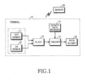
- FIG. 1 is a schematic block diagram illustrating a conventional off-board navigation system. Referring to FIG. 1, a
server 20 of the off-board navigation system stores a digital map. Theserver 20 carries out complex path calculations and generates guide information according to a request from aterminal 10 or operation condition which theserver 20 sets itself, such that a result of the calculation and the generated guide information are transmitted to theterminal 10. - The
terminal 10 of the off-board navigation system includes a sensor unit containing a global positioning system (GPS)sensor 11 and a dead reckoning (DR)sensor 12, afilter 13, aserver data receiver 14, atracker 15 and apath guider 16. - The
GPS sensor 11 is used for receiving a GPS signal. That is, theGPS sensor 11 receives the GPS signal and detects car position information (x, y, z) and current time information t from the received GPS signal. TheDR sensor 12 determines a relative self position and a traveling direction, and detects the car's velocity v and angle . Thefilter 13 is implemented by a GPS/DR integration filter, receives the car position information (x; y, z) and time information t from theGPS sensor 11, and receives the car's velocity v and angle , such that the car's current position can be calculated. Theserver data receiver 14 receives the path calculation result and guide information. Thetracker 15 receives data from theserver 20 through theserver data receiver 14 and receives a current position measurement result from thefilter 13. Thetracker 15 compares path information from theserver 20 with a current position, and tracks a current traveling state to transfer relevant information to thepath guider 16. The path guider 16 guides a user along a path using the traveling state information generated from thetracker 15. - As described above, the conventional navigation system without a digital map determines a current position using information from the
server 20. The conventional navigation system performs only a guide operation, but disables a sensor calibration operation of theterminal 10. - Furthermore, having no sensor provides calibration data associated with current position data in the off-board navigation system without a digital map. Consequently, the off-board navigation system cannot accurately perform a calibration operation for the current position data containing an error caused by an error of the GPS sensor and DR sensor. The accuracy of navigation service provided by the conventional navigation system is degraded according to a sensor error. For example, when guide information associated with an optimum path is conventionally provided, erroneous information associated with a guide time-point and derailment can be generated by the sensor error.
- Therefore, the present invention is provided in view of the above problems.
- It is the object of the present invention to provide an off-board navigation system and method for calibrating for errors that can improve the accuracy of navigation service using the off-board navigation system.
- This object is solved by the subject matter of the independent claims.
- Preferred embodiments are defined in the dependent claims.
- It is an aspect of the present invention to provide an off-board navigation system and method for calibrating for sensor errors in the off-board navigation system to perform accurate position determination.
- It is another aspect of the present invention to provide an off-board navigation system and method for calibrating for sensor errors of a moving terminal provided in the off-board navigation system using optimum calibration data from a server provided in the off-board navigation system.
- In accordance with one aspect of the present invention, the above object can be accomplished by providing navigation system, comprising: a server for calculating a predetermined path using a pre-stored map in response to a request from a terminal, generating calibration information based upon the calculated path, and transmitting to the terminal the calculated path and the calibration information; and the terminal for requesting the calculations, receiving the calculated path and the calibration information from the server, comparing the calibration information and position information measured by sensors embedded in the terminal, and calibrating the sensors.
- In accordance with another aspect of the present invention, the above can be accomplished by providing a method for performing an error calibration operation in navigation system including a server and a terminal, comprising the steps of: (a) receiving and storing calibration section information designated by the server, and receiving current position data of the terminal from sensors embedded in the terminal; (b) comparing a current position of the terminal and the section information, and determining if the current position of the terminal is contained in a calibration section; (c) storing the current position data of the terminal if the current position of the terminal is contained in the calibration section, and receiving next position data from the sensors; (d) comparing the stored position data with data of the calibration section if the current position of the terminal is not contained in the calibration section, and generating sensor calibration data; and (e) calibrating the sensors using the sensor calibration data.
- The above object and other aspects, features and other advantages of the present invention will be more clearly understood from the following detailed description taken in conjunction with the accompanying drawings, in which:
- FIG. 1 is a block diagram illustrating a conventional off-board navigation system;
- FIG. 2 is a flow chart illustrating a processing method for use in an off-board navigation system in accordance with one embodiment of the present invention;
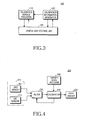
- FIG. 3 is a block diagram illustrating a server provided in the off-board navigation system in accordance with one embodiment of the present invention;
- FIG. 4 is a block diagram illustrating a terminal provided in the off-board navigation system in accordance with one embodiment of the present invention;
- FIGS. 5A and 5B are diagrams illustrating a position calibration process in accordance with one embodiment of the present invention;
- FIG. 6 is a flow chart illustrating a method for performing a position calibration operation in the off-board navigation system in accordance with one embodiment of the present invention; and
- FIG. 7 is a flow chart illustrating a sensor calibration operation in the off-board navigation system in accordance with one embodiment of the present invention.
-
- Now, preferred embodiments of the present invention will be described in detail with reference to the annexed drawings. In the drawings, the same or similar elements are denoted by the same reference numerals even though they are depicted in different drawings. In the following description, a detailed description of known functions and configurations incorporated herein will be omitted when it may obscure the subject matter of the present invention.
- FIG. 2 is a flow chart illustrating a processing method for use in an off-board navigation system in accordance with one embodiment of the present invention. The processing method for use in the off-board navigation system in accordance with the one embodiment of the present invention will now be described with reference to FIG. 2.
- First, a
terminal 200 transmits a path guide request message containing current position information and destination information to a server 100 (S102). Theserver 100 calculates a path between a current position and a destination in response to the path guide request message, and generates calibration information from the calculated path (S104). The generated calibration information includes section information (e.g., an intersection, etc.) so that a position calibration operation can be easily performed. If an intersection is positioned on the calculated path, the server generates intersection information as the calibration information. The calibration information and path guide information based upon a result of the path calculation are transmitted to the terminal 200 (S108). - The
terminal 200 measures a current position of theterminal 200 after making the path guide request (S106). Theterminal 200 calibrates position measurement sensors (e.g., the GPS and DR sensors) provided in theterminal 200 using the calibration information received at the above step S108 (S110), and then performs a path guide service (S112). - FIGS. 3 and 4 are block diagrams illustrating the
server 100 and the terminal 200. Referring to FIGS. 3 and 4, the present invention will be described in detail. - First, FIG. 3 is a block diagram illustrating the
server 100 provided in the off-board navigation system in accordance with one embodiment of the present invention. Referring to FIG. 3, theserver 100 of the off-board navigation system in accordance with the one embodiment of the present invention provides information (e.g., optimum path, point of interest (POI) and search information, etc.) requested by the terminal 200 using a pre-stored digital map, and includes atelematics service provider 110, acalibration information generator 120 and a digitalmap storing unit 130. - The digital
map storing unit 130 stores at least one previously generated digital map. - The
telematics service provider 110 provides a telematics service using the digital map stored in the digitalmap storing unit 130. The term "telematics" is a compound word of telecommunication and informatics. The telematics service is based upon technology capable of providing various application services (e.g., services for providing information of car accident or robbery detection, driving path guide, traffic, living, games, etc.) to a driver in real time by applying, to a car, telecommunication technology and positioning technology. Thus, the telematics service includes service for providing path guide information to the terminal mounted in the car using a communication network in the navigation system of the present invention. - That is, the
telematics service provider 110 generates service information (e.g., optimum path search, POI search and traffic information) relating to a traveling car, and provides the generated service information to the terminal through the communication network. If the terminal has referred to the digital map and has made an optimum path search request, thetelematics service provider 110 searches an optimum path using link and node information serving as network data of the digital map. However, if the terminal has made an optimum path search request containing an additional request for calibration information, thetelematics service provider 110 searches an optimum path using a corresponding weight value mapped to the calibration information. - The
calibration information generator 120 generates information necessary for a sensor calibration operation of the terminal provided in the navigation system. When position information (e.g., intersection information), which allows the sensor calibration operation to be performed while the optimum path search is used, is detected, the calibration information is generated using the detected position information. Network information of the digital map mapped to corresponding position information is generated as the calibration information. The generated calibration information is transmitted to the terminal by a radio signal. It is preferable that thecalibration information generator 120 sets a predetermined section corresponding to a sensor calibration position as a calibration section, and transmits information of the set predetermined section. - FIG. 4 is a block diagram illustrating the terminal 200 provided in the off-board navigation system in accordance with one embodiment of the present invention. Referring to FIG. 4, the
terminal 200 of the off-board navigation system in accordance with the one embodiment of the present invention detects a current position and compares the detected current position with position information received from the server so that proper guide information can be provided to the user. The terminal 200 includes asensor unit 210, afilter 220, aserver data receiver 230, acalibrator 240 and apath guider 250. - The
sensor unit 210 is a device for determining the current position of a car, and includes a global positioning system (GPS) sensor 211 and a dead reckoning (DR)sensor 213. The GPS sensor 211 receives a GPS signal and then detects car position information (x, y, z) and time information t using the received GPS signal. TheDR sensor 213 determines relative self position and a traveling direction using previous position information, and detect the car's velocity v and angle . - The
filter 220 produces final position data by filtering measured position data of a car input from thesensor unit 210. That is, thefilter 220 receives the car position information (x, y, z) and the time information t from the GPS sensor 211, and receives the car's velocity v and angle from theDR sensor 213 to produce the final position data. Because the position data from the GPS sensor 211 and the position data from theDR sensor 213 that are input into thefilter 220 include errors, a current position detected using the position data always contains an error. - Accordingly, in order for the system to be calibrated to compensate for the errors, the
server data receiver 230 receives calibration information along with optimum path information from theserver 100. Theserver data receiver 230 stores the calibration information. It is preferable that the calibration information is section information containing position data of an intersection on the optimum path. - The
calibrator 240 generates sensor calibration data using current position data produced by thefilter 220 and the calculation information stored in theserver data receiver 230. Thecalibrator 240 generates a calibration value to compensate for a sensor error where the current position data is contained in calibration section information transferred from the server. Thecalibrator 240 transfers the generated calibration value to thefilter 220. Thefilter 220 calibrates output data of thesensor unit 210 containing an error using the calibration value. - Typically, the sensor calibration is carried out in the
filter 220 using the GPS and DR system, or by performing a calibration operation after performing a map-matching operation associated with a current position using a digital map. The sensor calibration using the GPS can be enabled by performing a map-matching algorithm using the digital map. However, the off-board navigation system in which the digital map is not embedded cannot perform the sensor calibration. Thus, when theserver 100 transmits path guide data in accordance with the present invention, calibration information (e.g., calibration section information) for the sensor calibration is transmitted. The terminal 200 calibrates the sensors using the calibration information. - The calibrated data is provided to the user through the
path guider 250. The path guider 250 accurately provides a guide service to the user using the calibrated position data. - FIGS. 5A and 5B are diagrams illustrating a position calibration process in accordance with one embodiment of the present invention.
- The typical digital map contains various information (e.g., node, link and display information, etc.), while information transmitted from the server to the terminal in the navigation system contains only digital map information corresponding to the car's optimum path. FIG. 5A depicts car traveling log information contained in the digital map. The curve formed by the consecutive small triangles corresponds to car traveling log information on the digital map, and the X shape surrounding the curve represents roads. In the example of FIG. 5A, the car travels from a top right direction to a bottom right direction through an intersection.
- The path information and calibration information are shown in FIG. 5B. As shown in FIG. 5B, a plurality of O-shaped marks denote nodes and shape points, and a line connecting the nodes represents a link. The calibration information transferred from the server to the terminal in the navigation system configures node, shape point and link information as shown in FIG. 5B. The calibration information contains a calibration start point Pcs, a calibration point Pc and a calibration end point Pce. In this example, the calibration point Pc indicates a center of the intersection in the digital map. The calibration start point Pcs and the calibration end point Pce are contained in a calibration section being within a predetermined range from the calibration point Pc. The calibration start point Pcs and the calibration end point Pce are determined by the traveling direction of the car. The calibration section containing an optimum point (i.e., an optimum calibration point) for calibrating the sensors is calculated and inputted by the server. The optimum calibration point corresponds to a section for calibrating errors of Δx and Δy of the sensors and typically uses an intersection at which the car turned. The sensor error is calibrated at the intersection region when a current position and an intersection turning point are confirmed.
- FIG. 5A shows the calibration information containing a position information reference point P1, a position calibration target point P2 through which the car has actually traveled, and a position calibration value (Δx, Δy) based upon the position information reference point P1 and the position calibration target point P2. The position calibration value (Δx, Δy) indicates the difference between the position information reference point P1 and the position calibration target point P2.
- The
filter 220 shown in FIG. 4 calibrates a sensor value transferred from thesensor unit 210 shown in FIG. 4 according to the position calibration value (Δx, Δy), and generates final position data using the calibrated sensor value. - FIG. 6 is a flow chart illustrating a method for performing a position calibration operation in the off-board navigation system in accordance with one embodiment of the present invention. Referring to FIG. 6, the terminal of the off-board navigation system receives position data from the sensor unit embedded therein (S110). A determination is made as to whether a position corresponding to the position data is contained in a calibration section designated by the server (S120). In order for the determination to be performed, the terminal must receive calibration section information from the server.
- If a position corresponding to the position data is not contained in a calibration section designated by the server, the terminal performs a position guide operation for the user using the position information (S170).
- If a position corresponding to the position data is contained in the calibration section designated by the server, the terminal stores the position data (S130) and receives new position data from the sensor unit embedded therein (S140). The position data received at step S140 corresponds to a position of the terminal according to the car traveling operation. An operation for storing the position data of the terminal at step S130 is performed, after accumulating an actual traveling path value of the terminal in the calibration section designated by the server, to reduce an error of the sensor unit embedded in the terminal using a comparison value between a traveling path value of the digital map corresponding to the section and the accumulated traveling path value.
- The terminal receiving the new position data at step S140 compares the new position data with the calibration section designated by the server, and determines if the terminal has passed the calibration section (S150). If the terminal has not passed the calibration section , the above steps S130 and S140 are repeated. The terminal continuously stores position data received from the sensor unit until the terminal passes the calibration section.
- If the terminal has passed the calibration section, position data corresponding to an actual traveling path value of the terminal stored at the above steps S130 and S140 is compared with position data of the digital map corresponding to the calibration section, and then the sensor unit embedded in the terminal is calibrated.
- FIG. 7 is a flow chart illustrating the sensor calibration operation (S160) in the off-board navigation system in accordance with one embodiment of the present invention. Referring to FIG. 7, the sensor calibration operation will be described in detail.
- The terminal detects its actual rotation point from the stored position data while traveling through the calibration section (S161). The terminal reads a calibration position designated by the server (S163), and calculates the difference (Δx, Δy) between the detected rotation point and the calibration position (S165).
- The following
Equation 1 is used to calculate the difference.Equation 1 - In
Equation 1, "calibration_position" denotes a calibration position designated by the server, and "sensor rotation_point" denotes a car rotation point, i.e., an actual traveling position. - The difference value (Δx, Δy) has been calculated at step S165. The sensors (e.g., the GPS sensor and DR sensor) embedded in the terminal are calibrated using the produced difference value (Δx, Δy) (S167).
- As described above, the server of the off-board navigation system allows the terminal to calibrate a sensor error using optimum calibration data while performing a traveling operation, such that the off-board navigation system can compensate for a position error between map information and actual traveling information. Therefore, the off-board navigation system can improve the accuracy of navigation service.
- Although the preferred embodiments of the present invention have been disclosed for illustrative purposes, those skilled in the art will appreciate that various modifications, additions and substitutions are possible, without departing from the scope of the invention. Accordingly, the present invention is not limited to the above-described embodiments, but the present invention is defined by the claims.
Claims (11)
- A navigation system, comprising:a server for calculating a predetermined path using a pre-stored map in response to a request from a terminal, generating calibration information based upon the calculated path, and transmitting to the terminal the calculated path and the calibration information; andthe terminal for requesting the calculations, receiving the calculated path and the calibration information from the server, comparing the calibration information and position information measured by sensors embedded in the terminal, and calibrating the sensors.
- The navigation system as set forth in claim 1, wherein the calibration information is section information necessary for performing a position calibration operation in relation to the path calculated by the server.
- The navigation system as set forth in claim 1 or 2, being adapted for compensating for information that is section information necessary for simultaneously calibrating an error of an "x" coordinate value and an error of a "y" coordinate value associated with position data.
- The navigation system as set forth in claim 3, wherein the calibration information is the section information containing position data of an intersection on the calculated path.
- The navigation system as set forth in claim 4, wherein the calibration information contains position data of a calibration start point, a calibration point and a calibration end point.
- The navigation system as set forth in any one of claims 1 to 5, wherein the server comprises:a digital map storing unit for storing a pre-generated digital map;a telematics service provider for generating telematics service information containing path guide service information using the digital map stored in the digital map storing unit, and providing the generated telematics service information to the terminal; anda calibration information generator for generating the calibration information necessary for enabling the terminal to perform the sensor calibration operation using the path guide service information generated from the telematics service provider, and providing the calibration information to the terminal.
- The navigation system as set forth in any one of claims 1 to 6, wherein the terminal comprises:a sensor unit for measuring a current position of a moving object;a filter for filtering measured position data of the moving object outputted from the sensor unit and producing final position data;a server data receiver for receiving the calibration information along with optimum path information from the server and storing the received calibration information; anda calibrator for comparing the final position data of the moving object produced by the filter with the calibration information stored in the server data receiver, generating sensor calibration data, and transmitting the generated sensor calibration data to the filter.
- The navigation system as set forth in claim 7, wherein the sensor unit comprises:a GPS sensor for detecting position information and time information using a GPS signal; anda dead reckoning sensor for detecting a relative self position and a traveling direction.
- The navigation system as set forth in claim 8, wherein the filter calibrates output values of the sensor unit using the sensor calibration data input from the calibrator.
- A method for performing an error calibration operation in a navigation system including a server and a terminal, comprising the steps of:(a) receiving and storing calibration section information designated by the server, and receiving current position data of the terminal from sensors embedded in the terminal;(b) comparing a current position of the terminal and the section information, and determining of the current position of the terminal is contained in a calibration section;(c) storing the current position data of the terminal if the current position of the terminal is contained in the calibration section, and receiving next position data from the sensors;(d) comparing the stored position data with data of the calibration section if the current position of the terminal is not contained in the calibration section, and generating sensor calibration data; and(e) calibrating the sensors using the sensor calibration data.
- The method as set forth in claim 10, wherein step (d) comprises the steps of:(d-1) detecting an actual rotation point of the terminal from the stored position data;(d-2) reading the calibration section information received from the server and comparing the calibration section information and the actual rotation point; and(d-3) generating the sensor calibration data according to a result of the comparison.
Applications Claiming Priority (2)
| Application Number | Priority Date | Filing Date | Title |
|---|---|---|---|
| KR2003079869 | 2003-11-12 | ||
| KR10-2003-0079869A KR100526571B1 (en) | 2003-11-12 | 2003-11-12 | Off-board navigation system and method for calibrating error using the same |
Publications (2)
| Publication Number | Publication Date |
|---|---|
| EP1531441A2 true EP1531441A2 (en) | 2005-05-18 |
| EP1531441A3 EP1531441A3 (en) | 2006-06-28 |
Family
ID=34431756
Family Applications (1)
| Application Number | Title | Priority Date | Filing Date |
|---|---|---|---|
| EP04018839A Ceased EP1531441A3 (en) | 2003-11-12 | 2004-08-09 | Off-board navigation system and method for calibrating error using the same |
Country Status (4)
| Country | Link |
|---|---|
| US (1) | US20050102096A1 (en) |
| EP (1) | EP1531441A3 (en) |
| KR (1) | KR100526571B1 (en) |
| CN (1) | CN1320337C (en) |
Families Citing this family (17)
| Publication number | Priority date | Publication date | Assignee | Title |
|---|---|---|---|---|
| US6913046B2 (en) * | 2002-10-24 | 2005-07-05 | Gilbarco Inc. | Fuel dispenser shear valve assembly |
| KR100753933B1 (en) * | 2005-12-29 | 2007-08-31 | 에스케이에너지 주식회사 | Method, system and server for selecting location and user terminal |
| CN102207395B (en) * | 2010-03-31 | 2015-04-08 | 上海博泰悦臻网络技术服务有限公司 | Application method of an on-board road book |
| CN102207944A (en) * | 2010-03-31 | 2011-10-05 | 上海博泰悦臻电子设备制造有限公司 | Application method of vehicle-mounted road book |
| CN103257372B (en) * | 2012-02-20 | 2016-12-14 | 宇龙计算机通信科技(深圳)有限公司 | Mobile terminal |
| WO2015097909A1 (en) | 2013-12-27 | 2015-07-02 | 株式会社小松製作所 | Mining-machine management system, mining machine, and management method |
| CN104977020B (en) * | 2014-04-02 | 2017-12-29 | 北京自动化控制设备研究所 | A kind of course error suppressing method applied to personal indoor navigation system |
| CN103969469A (en) * | 2014-05-09 | 2014-08-06 | 深圳市美赛达科技股份有限公司 | Calibrating system and method applied to vehicle monitoring terminal |
| DE102014220687A1 (en) | 2014-10-13 | 2016-04-14 | Continental Automotive Gmbh | Communication device for a vehicle and method for communicating |
| EP3358300B1 (en) * | 2015-09-30 | 2020-02-12 | Huawei Technologies Co., Ltd. | Calibration method based on dead reckoning technique, and portable electronic device |
| DE102015220355A1 (en) * | 2015-10-20 | 2017-04-20 | Robert Bosch Gmbh | Substitution of sensor measurement data |
| CN108168567A (en) * | 2017-11-22 | 2018-06-15 | 东南大学 | A kind of method that high accuracy positioning service is realized based on electronic map |
| CN110319851B (en) * | 2018-03-30 | 2022-03-01 | 北京百度网讯科技有限公司 | Sensor correction method, device, equipment and storage medium |
| WO2020171267A1 (en) * | 2019-02-22 | 2020-08-27 | 엘지전자 주식회사 | Path provision apparatus and communication system comprising same |
| WO2020171262A1 (en) * | 2019-02-22 | 2020-08-27 | 엘지전자 주식회사 | Path providing apparatus and communication system including same |
| CN114608563B (en) * | 2022-05-11 | 2022-07-26 | 成都瑞讯物联科技有限公司 | Navigation map generation method and fusion positioning navigation method |
| CN116698086B (en) * | 2023-07-31 | 2023-10-20 | 中国人民解放军国防科技大学 | Error joint calibration method and device of bionic polarization vision navigation sensor |
Citations (3)
| Publication number | Priority date | Publication date | Assignee | Title |
|---|---|---|---|---|
| EP0243635A2 (en) * | 1986-03-14 | 1987-11-04 | Sumitomo Electric Industries Limited | Roadside beacon system |
| EP0806632A1 (en) * | 1996-05-09 | 1997-11-12 | MAGNETI MARELLI S.p.A. | Vehicle navigation system with automatic calibration of on-board sensors |
| US20030055555A1 (en) * | 1997-08-19 | 2003-03-20 | Siemens Automotive Corporation, A Delaware Corporation | Vehicle information system |
Family Cites Families (5)
| Publication number | Priority date | Publication date | Assignee | Title |
|---|---|---|---|---|
| GB8525850D0 (en) * | 1985-10-19 | 1985-11-20 | Save The Children | Pump |
| US5359529A (en) * | 1992-05-15 | 1994-10-25 | Zexel Corporation | Route guidance on/off-route state filter |
| DE19640735A1 (en) * | 1996-10-02 | 1998-04-23 | Bosch Gmbh Robert | Telematics device for a motor vehicle |
| CN1280611C (en) * | 2001-04-25 | 2006-10-18 | 滕春霖 | Sound controlled interactive global navigation system and method |
| KR20040099353A (en) * | 2002-03-28 | 2004-11-26 | 마쯔시다덴기산교 가부시키가이샤 | Relative location data correction apparatus, relative location data correction method, relative location data correction program, shape data generation apparatus, shape data generation method and shape data generation program |
-
2003
- 2003-11-12 KR KR10-2003-0079869A patent/KR100526571B1/en not_active IP Right Cessation
-
2004
- 2004-07-14 US US10/890,706 patent/US20050102096A1/en not_active Abandoned
- 2004-08-09 EP EP04018839A patent/EP1531441A3/en not_active Ceased
- 2004-08-11 CN CNB2004100564918A patent/CN1320337C/en not_active Expired - Fee Related
Patent Citations (3)
| Publication number | Priority date | Publication date | Assignee | Title |
|---|---|---|---|---|
| EP0243635A2 (en) * | 1986-03-14 | 1987-11-04 | Sumitomo Electric Industries Limited | Roadside beacon system |
| EP0806632A1 (en) * | 1996-05-09 | 1997-11-12 | MAGNETI MARELLI S.p.A. | Vehicle navigation system with automatic calibration of on-board sensors |
| US20030055555A1 (en) * | 1997-08-19 | 2003-03-20 | Siemens Automotive Corporation, A Delaware Corporation | Vehicle information system |
Also Published As
| Publication number | Publication date |
|---|---|
| CN1320337C (en) | 2007-06-06 |
| KR100526571B1 (en) | 2005-11-04 |
| US20050102096A1 (en) | 2005-05-12 |
| EP1531441A3 (en) | 2006-06-28 |
| KR20050045704A (en) | 2005-05-17 |
| CN1617186A (en) | 2005-05-18 |
Similar Documents
| Publication | Publication Date | Title |
|---|---|---|
| US7756639B2 (en) | System and method for augmenting a satellite-based navigation solution | |
| KR100713459B1 (en) | Method for determinig deviation of the path of a mobile in navigation system and navigation system | |
| EP1531441A2 (en) | Off-board navigation system and method for calibrating error using the same | |
| EP0870174B1 (en) | Improved vehicle navigation system and method using gps velocities | |
| US6381536B1 (en) | Apparatus for generating road information from stored digital map database | |
| EP0870175B1 (en) | A zero motion detection system for improved vehicle navigation system | |
| JP4550255B2 (en) | Method and apparatus for improving dead reckoning distance calculations for vehicle navigation systems | |
| US7349802B2 (en) | Apparatus and method for detecting vehicle location in navigation system | |
| EP0870173B1 (en) | Improved vehicle navigation system and method | |
| US7987047B2 (en) | Navigation equipment | |
| KR100717300B1 (en) | A dead reckoning sensor correction method of navigation system on vehicle | |
| US6597987B1 (en) | Method for improving vehicle positioning in a navigation system | |
| EP0900362B1 (en) | A method and apparatus for differential scale factor calibration in differential odometry systems integrated with gps | |
| JP4652097B2 (en) | Altitude calculation device and navigation device | |
| JP3877011B2 (en) | Position detection apparatus for automobiles having a satellite receiver | |
| KR100948089B1 (en) | Method for deciding car position by pseudo dead reckoning and car navigation system using the same | |
| US20100299059A1 (en) | Method for operating a navigation system and a navigation system | |
| WO2000050917A1 (en) | Vehicle navigation system with correction for selective availability | |
| US7400946B2 (en) | Method and apparatus for measuring velocity of land vehicle using accelerometer and route guidance information data | |
| KR100675362B1 (en) | Car Navigation System and Control Method Thereof | |
| EP0944812B1 (en) | Method and apparatus for calibration of the wheel track | |
| KR100541485B1 (en) | Navigation guidance for car and method for car navigation guidance using the same | |
| KR20200065131A (en) | Apparatus and method for measuring altitude using sensor fusion | |
| JP2013083464A (en) | Navigation device | |
| JP2009025116A (en) | Navigation system |
Legal Events
| Date | Code | Title | Description |
|---|---|---|---|
| PUAI | Public reference made under article 153(3) epc to a published international application that has entered the european phase |
Free format text: ORIGINAL CODE: 0009012 |
|
| 17P | Request for examination filed |
Effective date: 20040809 |
|
| AK | Designated contracting states |
Kind code of ref document: A2 Designated state(s): AT BE BG CH CY CZ DE DK EE ES FI FR GB GR HU IE IT LI LU MC NL PL PT RO SE SI SK TR |
|
| AX | Request for extension of the european patent |
Extension state: AL HR LT LV MK |
|
| PUAL | Search report despatched |
Free format text: ORIGINAL CODE: 0009013 |
|
| AK | Designated contracting states |
Kind code of ref document: A3 Designated state(s): AT BE BG CH CY CZ DE DK EE ES FI FR GB GR HU IE IT LI LU MC NL PL PT RO SE SI SK TR |
|
| AX | Request for extension of the european patent |
Extension state: AL HR LT LV MK |
|
| 17Q | First examination report despatched |
Effective date: 20060928 |
|
| AKX | Designation fees paid |
Designated state(s): DE FR GB |
|
| APBN | Date of receipt of notice of appeal recorded |
Free format text: ORIGINAL CODE: EPIDOSNNOA2E |
|
| APBR | Date of receipt of statement of grounds of appeal recorded |
Free format text: ORIGINAL CODE: EPIDOSNNOA3E |
|
| APAF | Appeal reference modified |
Free format text: ORIGINAL CODE: EPIDOSCREFNE |
|
| APBT | Appeal procedure closed |
Free format text: ORIGINAL CODE: EPIDOSNNOA9E |
|
| STAA | Information on the status of an ep patent application or granted ep patent |
Free format text: STATUS: THE APPLICATION HAS BEEN REFUSED |
|
| 18R | Application refused |
Effective date: 20120209 |