EP1475725A2 - A system and method employing a grid index for location and precision encoding - Google Patents
A system and method employing a grid index for location and precision encoding Download PDFInfo
- Publication number
- EP1475725A2 EP1475725A2 EP04008439A EP04008439A EP1475725A2 EP 1475725 A2 EP1475725 A2 EP 1475725A2 EP 04008439 A EP04008439 A EP 04008439A EP 04008439 A EP04008439 A EP 04008439A EP 1475725 A2 EP1475725 A2 EP 1475725A2
- Authority
- EP
- European Patent Office
- Prior art keywords
- grid
- computer
- index
- implemented process
- location
- Prior art date
- Legal status (The legal status is an assumption and is not a legal conclusion. Google has not performed a legal analysis and makes no representation as to the accuracy of the status listed.)
- Withdrawn
Links
Images




Classifications
-
- H—ELECTRICITY
- H04—ELECTRIC COMMUNICATION TECHNIQUE
- H04M—TELEPHONIC COMMUNICATION
- H04M1/00—Substation equipment, e.g. for use by subscribers
- H04M1/72—Mobile telephones; Cordless telephones, i.e. devices for establishing wireless links to base stations without route selection
- H04M1/724—User interfaces specially adapted for cordless or mobile telephones
- H04M1/72448—User interfaces specially adapted for cordless or mobile telephones with means for adapting the functionality of the device according to specific conditions
- H04M1/72454—User interfaces specially adapted for cordless or mobile telephones with means for adapting the functionality of the device according to specific conditions according to context-related or environment-related conditions
-
- G—PHYSICS
- G06—COMPUTING OR CALCULATING; COUNTING
- G06F—ELECTRIC DIGITAL DATA PROCESSING
- G06F16/00—Information retrieval; Database structures therefor; File system structures therefor
- G06F16/20—Information retrieval; Database structures therefor; File system structures therefor of structured data, e.g. relational data
- G06F16/24—Querying
- G06F16/245—Query processing
- G06F16/2453—Query optimisation
-
- G—PHYSICS
- G06—COMPUTING OR CALCULATING; COUNTING
- G06F—ELECTRIC DIGITAL DATA PROCESSING
- G06F16/00—Information retrieval; Database structures therefor; File system structures therefor
- G06F16/20—Information retrieval; Database structures therefor; File system structures therefor of structured data, e.g. relational data
- G06F16/29—Geographical information databases
-
- G—PHYSICS
- G06—COMPUTING OR CALCULATING; COUNTING
- G06F—ELECTRIC DIGITAL DATA PROCESSING
- G06F16/00—Information retrieval; Database structures therefor; File system structures therefor
- G06F16/80—Information retrieval; Database structures therefor; File system structures therefor of semi-structured data, e.g. markup language structured data such as SGML, XML or HTML
- G06F16/84—Mapping; Conversion
-
- H—ELECTRICITY
- H04—ELECTRIC COMMUNICATION TECHNIQUE
- H04M—TELEPHONIC COMMUNICATION
- H04M1/00—Substation equipment, e.g. for use by subscribers
- H04M1/26—Devices for calling a subscriber
- H04M1/27—Devices whereby a plurality of signals may be stored simultaneously
- H04M1/274—Devices whereby a plurality of signals may be stored simultaneously with provision for storing more than one subscriber number at a time, e.g. using toothed disc
- H04M1/2745—Devices whereby a plurality of signals may be stored simultaneously with provision for storing more than one subscriber number at a time, e.g. using toothed disc using static electronic memories, e.g. chips
- H04M1/275—Devices whereby a plurality of signals may be stored simultaneously with provision for storing more than one subscriber number at a time, e.g. using toothed disc using static electronic memories, e.g. chips implemented by means of portable electronic directories
-
- H—ELECTRICITY
- H04—ELECTRIC COMMUNICATION TECHNIQUE
- H04M—TELEPHONIC COMMUNICATION
- H04M2201/00—Electronic components, circuits, software, systems or apparatus used in telephone systems
- H04M2201/34—Microprocessors
-
- H—ELECTRICITY
- H04—ELECTRIC COMMUNICATION TECHNIQUE
- H04M—TELEPHONIC COMMUNICATION
- H04M2250/00—Details of telephonic subscriber devices
- H04M2250/12—Details of telephonic subscriber devices including a sensor for measuring a physical value, e.g. temperature or motion
Definitions
- This invention is directed toward a system and method for location and precision encoding. More specifically, the invention is directed toward a system and method for combining the precision estimate of a database entry's coordinate value such that the precision information is included as part of a one-dimensional index.
- GIS Geographic Information Systems
- elements are associated with geographical regions at different scales, and queries may be performed over a range of scales.
- queries may be performed over a range of scales.
- an item may be associated with the city of New York as a whole or more specifically with the city block representing the Empire State Building.
- queries it may be useful to retrieve all items taken at the Empire State Building when querying for photos taken in New York City, but the converse may be undesirable - not all photos taken in New York City will be relevant to a query about the Empire State Building.
- the invention is directed toward a system and method for combining the precision estimate of a database entry's coordinate value such that the precision information is included as part of a one-dimensional index by constructing a hierarchical index in which the size of the grid is related to the precision of the coordinate value.
- a grid index is a gridding of an n-dimensional space into a regular partition of the grid space forming grid units, for which for a point in space, x, there is a function index (x), which retrieves a unique integer value for the grid that contains Point x.
- a hierarchical grid index is effectively a number of grid indices overlaid on the same space, with grid units of different sizes. In this case, each of the functions requires an additional argument which specifies the size of the grid unit to use.
- S, Index (x,s) returns a unique integer value for the grid of size s that contains Point x.
- Hierarchical indexes are used to enhance the performance of database queries. A query that seeks results from a small grid size, s small , does not seek matches at a large grid size, s large .
- a grid index can be used for which for a finite area in space, A, there is a function index (A) which retrieves a unique integer value for a grid that wholly contains Area A.
- one or more location entities are input into the system and method according to the invention.
- the grid index series is then computed wherein each grid is represented as a series of grids that incorporate the location of each location entity. This grid index series can then be output to a database.
- one embodiment of the system and method according to the invention uses an equirectangular projection (also known as "unprojected lat/long”), in which latitude/longitude (lat/long) values of location entities are taken as straight x-y pairs on a Euclidean coordinate system and input into the system.
- the globe is then gridded at twenty different resolutions, with "square" units whose sides correspond to 20x(1 ⁇ 2) r degrees, for 0 ⁇ r ⁇ 20. At the equator, these values correspond to scales ranging from ⁇ 240km down to ⁇ 0.5m.
- each grid is indexed in raster-scan order.
- a given longitude/latitude coordinate ( long , lat ), whose measurement error is expected to be normally distributed with standard deviation ⁇ meters would be indexed as follows.
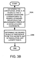
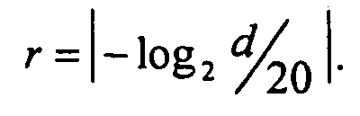
- the degree-scale of precision, r is determined to be the discrete unit of resolution that is just larger than d :
- the coordinate ( long , lat ) is mapped to the index, The coordinate as mapped to the index can then be output to a database.
- the representation described above conveniently packages 2D lat/long coordinates together with precision, and it can be used to index items in a database with a single 8-byte index. If queries are issued for all of the items in a particular grid, it would be necessary to make multiple queries to retrieve items with location tags that are more precise than the given grid. Querying for all items taken over a large area would be computationally expensive and time consuming. To avoid this, twenty fields (one per grid resolution) are used, each of which represents the location of an item at a particular precision. For a given item with ( long , lat ) and precision r *, l r is computed, for all r ⁇ r *; and, for r ⁇ r *, a value of null is assigned.
- This scheme allows one to query for all of the items that are known to occur within a particular grid at precision r, with a single, exact-match query over the field representing location at precision r . Note that items whose location-tag precisions are coarser than that queried for will not be returned, even if the grids intersect (this inverts the standard usage of hierarchical grid indexes).
- the system and method according to the invention is advantageous in that it can query very large databases in a fraction of the time it would take to generate a multidimensional query, as would be typical in traditional database schema.
- FIG. 1 illustrates an example of a suitable computing system environment 100 on which the invention may be implemented.
- the computing system environment 100 is only one example of a suitable computing environment and is not intended to suggest any limitation as to the scope of use or functionality of the invention. Neither should the computing environment 100 be interpreted as having any dependency or requirement relating to any one or combination of components illustrated in the exemplary operating environment 100.
- the invention is operational with numerous other general purpose or special purpose computing system environments or configurations.
- Examples of well known computing systems, environments, and/or configurations that may be suitable for use with the invention include, but are not limited to, personal computers, server computers, hand-held or laptop devices, multiprocessor systems, microprocessor-based systems, set top boxes, programmable consumer electronics, network PCs, minicomputers, mainframe computers, distributed computing environments that include any of the above systems or devices, and the like.
- the invention may be described in the general context of computer-executable instructions, such as program modules, being executed by a computer.
- program modules include routines, programs, objects, components, data structures, etc. that perform particular tasks or implement particular abstract data types.
- the invention may also be practiced in distributed computing environments where tasks are performed by remote processing devices that are linked through a communications network.
- program modules may be located in both local and remote computer storage media including memory storage devices.
- an exemplary system for implementing the invention includes a general purpose computing device in the form of a computer 110.
- Components of computer 110 may include, but are not limited to, a processing unit 120, a system memory 130, and a system bus 121 that couples various system components including the system memory to the processing unit 120.
- the system bus 121 may be any of several types of bus structures including a memory bus or memory controller, a peripheral bus, and a local bus using any of a variety of bus architectures.
- such architectures include Industry Standard Architecture (ISA) bus, Micro Channel Architecture (MCA) bus, Enhanced ISA (EISA) bus, Video Electronics Standards Association (VESA) local bus, and Peripheral Component Interconnect (PCI) bus also known as Mezzanine bus.
- ISA Industry Standard Architecture
- MCA Micro Channel Architecture
- EISA Enhanced ISA
- VESA Video Electronics Standards Association
- PCI Peripheral Component Interconnect
- Computer 110 typically includes a variety of computer readable media.
- Computer readable media can be any available media that can be accessed by computer 110 and includes both volatile and nonvolatile media, removable and non-removable media.
- Computer readable media may comprise computer storage media and communication media.
- Computer storage media includes both volatile and nonvolatile, removable and non-removable media implemented in any method or technology for storage of information such as computer readable instructions, data structures, program modules or other data.
- Computer storage media includes, but is not limited to, RAM, ROM, EEPROM, flash memory or other memory technology, CD-ROM, digital versatile disks (DVD) or other optical disk storage, magnetic cassettes, magnetic tape, magnetic disk storage or other magnetic storage devices, or any other medium which can be used to store the desired information and which can be accessed by computer 110.
- Communication media typically embodies computer readable instructions, data structures, program modules or other data in a modulated data signal such as a carrier wave or other transport mechanism and includes any information delivery media.
- modulated data signal means a signal that has one or more of its characteristics set or changed in such a manner as to encode information in the signal.
- communication media includes wired media such as a wired network or direct-wired connection, and wireless media such as acoustic, RF, infrared and other wireless media. Combinations of the any of the above should also be included within the scope of computer readable media.
- the system memory 130 includes computer storage media in the form of volatile and/or nonvolatile memory such as read only memory (ROM) 131 and random access memory (RAM) 132.
- ROM read only memory
- RAM random access memory
- BIOS basic input/output system
- RAM 132 typically contains data and/or program modules that are immediately accessible to and/or presently being operated on by processing unit 120.
- FIG. 1 illustrates operating system 134, application programs 135, other program modules 136, and program data 137.
- the computer 110 may also include other removable/non-removable, volatile/nonvolatile computer storage media.
- FIG. 1 illustrates a hard disk drive 141 that reads from or writes to non-removable, nonvolatile magnetic media, a magnetic disk drive 151 that reads from or writes to a removable, nonvolatile magnetic disk 152, and an optical disk drive 155 that reads from or writes to a removable, nonvolatile optical disk 156 such as a CD ROM or other optical media.
- removable/non-removable, volatile/nonvolatile computer storage media that can be used in the exemplary operating environment include, but are not limited to, magnetic tape cassettes, flash memory cards, digital versatile disks, digital video tape, solid state RAM, solid state ROM, and the like.
- the hard disk drive 141 is typically connected to the system bus 121 through anon-removable memory interface such as interface 140, and magnetic disk drive 151 and optical disk drive 155 are typically connected to the system bus 121 by a removable memory interface, such as interface 150.
- hard disk drive 141 is illustrated as storing operating system 144, application programs 145, other program modules 146, and program data 147. Note that these components can either be the same as or different from operating system 134, application programs 135, other program modules 136, and program data 137. Operating system 144, application programs 145, other program modules 146, and program data 147 are given different numbers here to illustrate that, at a minimum, they are different copies.
- a user may enter commands and information into the computer 110 through input devices such as a keyboard 162 and pointing device 161, commonly referred to as a mouse, trackball or touch pad.
- Other input devices may include a joystick, game pad, satellite dish, scanner, or the like. These and other input devices are often connected to the processing unit 120 through a user input interface 160 that is coupled to the system bus 121, but may be connected by other interface and bus structures, such as a parallel port, game port or a universal serial bus (USB).
- a monitor 191 or other type of display device is also connected to the system bus 121 via an interface, such as a video interface 190.
- computers may also include other peripheral output devices such as speakers 197 and printer 196, which may be connected through an output peripheral interface 195.
- a camera 163 (such as a digital/electronic still or video camera, or film/photographic scanner) capable of capturing a sequence of images 164 can also be included as an input device to the personal computer 110. Further, while just one camera is depicted, multiple cameras could be included as an input device to the personal computer 110.
- the images 164 from the one or more cameras are input into the computer 110 via an appropriate camera interface 165.
- a microphone 168 may also be associated with the camera and input into the computer 110 with an interface 165 that is associated with one or more cameras.
- This interface 165 is connected to the system bus 121, thereby allowing the images to be routed to and stored in the RAM 132, or one of the other data storage devices associated with the computer 110.
- image data can be input into the computer 110 from any of the aforementioned computer-readable media as well, without requiring the use of the camera 163.
- the computer 110 may operate in a networked environment using logical connections to one or more remote computers, such as a remote computer 180.
- the remote computer 180 may be a personal computer, a server, a router, a network PC, a peer device or other common network node, and typically includes many or all of the elements described above relative to the computer 110, although only a memory storage device 181 has been illustrated in FIG. 1.
- the logical connections depicted in FIG. 1 include a local area network (LAN) 171 and a wide area network (WAN) 173, but may also include other networks.
- LAN local area network
- WAN wide area network
- Such networking environments are commonplace in offices, enterprise-wide computer networks, intranets and the Internet.
- the computer 110 When used in a LAN networking environment, the computer 110 is connected to the LAN 171 through a network interface or adapter 170. When used in a WAN networking environment, the computer 110 typically includes a modem 172 or other means for establishing communications over the WAN 173, such as the Internet.
- the modem 172 which may be internal or external, may be connected to the system bus 121 via the user input interface 160, or other appropriate mechanism.
- program modules depicted relative to the computer 110, or portions thereof may be stored in the remote memory storage device.
- FIG. 1 illustrates remote application programs 185 as residing on memory device 181. It will be appreciated that the network connections shown are exemplary and other means of establishing a communications link between the computers may be used.
- the invention is directed toward a system and method for combining the precision estimate of a database entry's coordinate value such that the precision information is included as part of the one-dimensional index by constructing a hierarchical index in which the size of the grid is related to the precision of the coordinate value.
- a hierarchical grid index is formed from a number of grid indices overlaid on the same space.
- a grid index is a gridding of an n-dimensional space into a regular partition of the grid space into grid units, for which for a point in space, x, there is a function index (x), which retrieves a unique integer value for the grid that contains Point x.
- a hierarchical grid index is effectively a number of grid indices overlaid on the same space, with grid units of different sizes.
- each of the functions employs an additional argument which specifies the size of the grid unit to use.
- S Index (x,s) returns a unique integer value for the grid of size s that contains Point x.
- Hierarchical indexes are used to enhance the performance of database queries. A query that seeks results from a small grid size, s small , does not seek matches at a large grid size, s large .
- a grid index can be used for which for a finite area in space, A, there is a function index (A) which retrieves a unique integer value for a grid that wholly contains Area A.
- FIG. 2 depicts a simplified flow diagram of the process actions of creating a database wherein the precision estimate of a database entry's coordinate value is combined such that information is included as part of the one-dimensional index. This is done by constructing a hierarchical index in which the size of the grid is related to the precision of the coordinate value.
- the location entities are input, as shown in process action 202.
- the location entities can be a point or a finite area.
- the grid index series is then computed wherein each grid is represented as a series of grids that incorporate the location of each location entity (process action 204). This index series can then be output to a database (process action 206).
- Parameters other than two-dimensional location (and time) are necessary to uniquely position a real-world object. These include altitude, up to three degrees of orientation specification, and possibly other parameters, depending on what the object is. In this discussion, examination is restricted to 2D location, as it is a manageable first step towards a broader understanding that incorporates the remaining parameters. However, it should be noted that the system and method according to the invention can process multi-dimensional location information.
- Georeferencing, or how location is represented, is a fundamental issue in GIS. Location can be represented in many ways: established place names ("San Francisco”), user-dependent place names (“Grandma's house”), street addresses, zip codes, latitude/longitude coordinates, Euclidean coordinates with respect to some origin, and so forth.
- GIS Geographic Information System
- location data structures For the purposes of browsing and interaction, one needs two additional types of location data structures: (1) for maps and queries, a notion of a physical region that corresponds to a map as displayed, and (2) for metadata-tagging, a data type that includes both lat/long coordinates and a measure of precision or resolution.
- Maps are most often displayed as rectangles on 2D displays. So, to represent a map, a structure that is called the area type is used, that is defined by a center lat/long, and width and height in kilometers, each measured from the center point and along lines of latitude and longitude. This defines a unique region on the globe that is "rectangular,” circumscribed by four great-circle arcs on the 3D globe. When projected onto 2D, an area appears roughly rectangular with sides that may deviate slightly from straight lines depending on the projection type, scale, and position on the globe.
- DGGSs discrete global grid systems
- one embodiment of the system and method according to the invention uses an equirectangular projection (also known as "unprojected lat/long”), in which lat/tong values are taken as straight x-y pairs on a Euclidean coordinate system (see FIG. 4(b)) and are input into the system (FIG. 3A, process action 302).
- the globe is gridded at twenty different resolutions, with "square" units whose sides correspond to 20x(1 ⁇ 2) r degrees, for 0 ⁇ r ⁇ 20.
- FIG. 4(b) shows 20-, 10-, and 5-degree gridding of the region outlined in FIG. 4(a). At the equator, these values correspond to scales ranging from ⁇ 240km down to ⁇ 0.5m. The gridding can occur are greater or fewer resolutions, if more or less precision is required.
- each grid is indexed in raster-scan order. So, a given longitude/latitude coordinate ( long, lat), whose measurement error is expected to be normally distributed with standard deviation ⁇ meters would be indexed as follows.
- the degree-scale of precision, r is determined to be the discrete unit of resolution that is just larger than d : as shown in process action 306B.
- a square grid with equirectangular projection is intuitive and keeps database queries efficient. But, it is inelegant in that the physical size and shape of grid units at the same indexing scale is distorted, particularly near the poles.
- Other gridding schemes can be used, however.
- a gridding scheme is employed that has minimal areal variation and shape distortion and uses a hierarchical series of equilateral polygons embedded within a Platonic solid.
- the major advantage of this gridding scheme is that at a fixed scale, units are of similar size and shape.
- the equations for determining the grid index given a coordinate and a coordinate given a grid index must be adapted for these alternate schemes.
- the representation described above conveniently packages 2D lat/long coordinates together with precision, and it can be used to index items in a database with a single 8-byte index.
- queries are issued for all of the items in a particular grid, it would be necessary to make multiple queries to retrieve items with location tags that are more precise than the given grid. Querying for all items taken over a large area would be computationally expensive and time-consuming.
- each of which in one embodiment represents the location of an item (e.g., location entity) at a particular precision.
- l r is computed as in Eq. 1, for all r ⁇ r *; and, for r ⁇ r *, a value of null is assigned.
- This scheme allows one to query for all of the items that are known to occur within a particular grid at precision r, with a single, exact-match query over the field representing location at precision r .
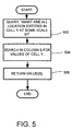
- FIG. 5 A flow diagram of the process actions of retrieving the desired data from a database of one database configured by the system and method of the invention is shown in FIG. 5.
- a user queries the database to return all location entities in a given cell y at a given scale S, as shown in process action 502.
- Column S of the database corresponding to the desired scale is then searched for values of cell y (process action 504) and these values are returned (process action 506). Note that all entities in the database table which occur within the grid represented by cell y will be included in the retrieval results, even those which occur at scales finer than cell y itself.
- the database contains a location entity ID 602 for each entry in the database.
- the latitude and longitude coordinates 604, as well as an indicator representing the grid scale 606, can also be recorded.
- the scale index at scale 1 provides a single integer that is the grid at a scale 1 that wholly contains the location representation or is set to null if it is not contained (as would be the case if the location representation were a finite area or region instead of a finite point).
- the scale index at scale 2 provides a single integer that represents a grid cell at a finer resolution than scale 1. And, so forth until scale N. If the finite area is not wholly contained within a given grid cell the scale index is set to a null value for this location representation.
Landscapes
- Engineering & Computer Science (AREA)
- Theoretical Computer Science (AREA)
- Databases & Information Systems (AREA)
- Data Mining & Analysis (AREA)
- Physics & Mathematics (AREA)
- General Engineering & Computer Science (AREA)
- General Physics & Mathematics (AREA)
- Signal Processing (AREA)
- Remote Sensing (AREA)
- Computational Linguistics (AREA)
- Environmental & Geological Engineering (AREA)
- Human Computer Interaction (AREA)
- Computer Networks & Wireless Communication (AREA)
- Information Retrieval, Db Structures And Fs Structures Therefor (AREA)
- Instructional Devices (AREA)
- Compression, Expansion, Code Conversion, And Decoders (AREA)
Abstract
Description

| Candidate Spatial Data Structures for Gridding. | |||||
| DGGS | Brief Description | Coordinate-Index Mapping | area-Index Mapping | Areal Variation | Shape Distortion |
| Lat/long gridding | Unprojected (long, lat) as cartesian x-y grid | Simple | Medium | High | High at poles |
| O-QTM [1] | Octahedral facets gridded by equilateral triangles | Medium | Complex | Low | Low |
| Dymaxion [1] | Icosahedral facets gridded by equilateral triangles | Complex | Complex | Low | Low |
| ISEA3H [2] | Equal-area hexagons and pentagons | Complex | Complex | None | Low |


Claims (30)
- A computer-implemented process for combining a precision estimate of a database entry's coordinate value with the coordinate value into a single index, comprising the process actions of:inputting one or more location entities; andcomputing a grid index series wherein each location entity is represented as a series of grids that incorporate the location of each location entity.
- The computer-implemented process of Claim 1 further comprising the process action of outputting said grid index series to a database.
- The computer-implemented process of Claim 1 wherein a location entity is a point.
- The computer-implemented process of Claim 1 wherein a location entity is an area.
- The computer-implemented process of Claim 4 wherein said area is defined by a center latitude and longitude and a width and a height, each measured from the center latitude and longitude and along lines of latitude and longitude.
- The computer-implemented process of Claim 1 wherein equirectangular projection is used to input latitude and longitude values of said one or more location entities as x-y pairs on a Euclidean coordinate system.
- The computer-implemented process of Claim 1 wherein the process action of computing a grid index series comprises:gridding the globe at a prescribed number of resolutions;indexing each grid in raster scan order; andmapping the latitude and longitude coordinates of each location entity to the index.
- The computer-implemented process of Claim 7 wherein the prescribed number of resolutions is 20.
- The computer-implemented process of Claim 7 wherein the process action of indexing each grid in raster scan order comprises:for each grid,
determining the longitudinal span, D, in degrees that three standard deviations corresponds to, where a standard deviation σ is the measurement error of a given latitude, longitude coordinate; and
determining the degree-scale of precision, R, to be the discrete unit of resolution just larger than D. - The computer-implemented process of Claim 9 wherein the longitudinal span in degrees that 3σ meters corresponds to is d = [180(3σ) cos(latitude)]/kπ is determined, where k is the circumference of the earth in meters.
- The computer-implemented process of Claim 9 wherein the process action of determining the degree-scale of precision, R, to be the discrete unit of resolution just larger than D comprises setting

- The computer-implemented process of Claim 7 wherein the globe is gridded with overlapping grids at each scale in order to increase accuracy.
- The computer-implemented process of Claim 12 wherein coordinates of location entities are mapped to the square whose center is closest.
- The computer-implemented process of Claim 1 wherein the location entity is geographic location data.
- The computer-implemented process of Claim 1 wherein the location entity is described in terms of latitude and longitude.
- The computer-implemented process of Claim 15 wherein the latitude and longitude values are taken as straight x-y pairs on a Euclidean coordinate system.
- The computer-implemented process of Claim 1 wherein the location entity is described in terms of latitude, longitude and altitude.
- The computer-implemented process of Claim 17 wherein the latitude, longitude and altitude values are taken as (x,y,z) pairs on a Euclidean coordinate system.
- The computer-implemented process of Claim 7 wherein the location entity's coordinates in latitude (lat) and longitude (long) is mapped to the index bywhere r is the degree-scale of precision, and l maps the coordinates to the location entity

- The computer-implemented process of Claim 19 wherein to recover the latitude and longitude values, the latitude (lat) and longitude (long) is calculated as:
- The computer-implemented process of Claim 2 wherein the database comprises a location entity identifier and a scale index for one or more scales each corresponding to a different grid.
- The computer-implemented process of Claim 2 wherein a query of the database comprises the following process actions:querying which location entities are in a given grid cell at a given grid scale;searching in the data of the given grid scale for the values of the given grid cell; andreturning said values of the given grid cell at the given grid scale.
- A system for indexing a multi-dimensional space with a one dimensional value, the system comprising:a general purpose computing device; anda computer program comprising program modules executable by the computing device, wherein the computing device is directed by the program modules of the computer program to,construct a hierarchical grid index from a number of grid indices overlaid on the same space with grid units of different sizes wherein the size of each grid is related to the precision of the coordinate values of a database entry.
- The system of Claim 23 wherein the database entry is a geographic location.
- The system of Claim 23 wherein the database entry is a time.
- A computer-readable medium having computer-executable instructions for combining a precision estimate of a database entry's coordinate value with the coordinate value into a single index, said computer executable instructions comprising:inputting one or more location entities; andcomputing a grid index series wherein each location entity is represented as a series of grids that incorporate the location of each location entity.
- The computer-readable medium of Claim 26 wherein the instruction computing a grid index series uses an equirectangular projection.
- The computer-readable medium of Claim 26 wherein the series of grids grid the globe at twenty different resolutions, with "square" units whose sides correspond to 20x(½) r degrees, for 0 ≤ r < 20.
- The computer-readable medium of Claim 26 wherein the series of grids is a hierarchical series of equilateral polygons embedded within a Platonic solid.
- The computer-readable medium of Claim 26 wherein the series of grids is a hierarchical series of polygons that grids the globe.
Applications Claiming Priority (4)
| Application Number | Priority Date | Filing Date | Title |
|---|---|---|---|
| US673111 | 1996-07-01 | ||
| US46931403P | 2003-05-09 | 2003-05-09 | |
| US469314P | 2003-05-09 | ||
| US10/673,111 US7966301B2 (en) | 2003-05-09 | 2003-09-26 | System and method for employing a grid index for location and precision encoding |
Publications (2)
| Publication Number | Publication Date |
|---|---|
| EP1475725A2 true EP1475725A2 (en) | 2004-11-10 |
| EP1475725A3 EP1475725A3 (en) | 2006-05-03 |
Family
ID=32995089
Family Applications (1)
| Application Number | Title | Priority Date | Filing Date |
|---|---|---|---|
| EP04008439A Withdrawn EP1475725A3 (en) | 2003-05-09 | 2004-04-07 | A system and method employing a grid index for location and precision encoding |
Country Status (5)
| Country | Link |
|---|---|
| US (1) | US7966301B2 (en) |
| EP (1) | EP1475725A3 (en) |
| JP (1) | JP2004334888A (en) |
| KR (1) | KR20040095751A (en) |
| CN (1) | CN1551020A (en) |
Cited By (5)
| Publication number | Priority date | Publication date | Assignee | Title |
|---|---|---|---|---|
| GB2408362A (en) * | 2003-11-21 | 2005-05-25 | Hewlett Packard Development Co | A method of storing an n-dimensional object in a data structure |
| CN112204340A (en) * | 2018-03-06 | 2021-01-08 | 南俄勒冈大学 | System and method for location representation using a discrete global grid system |
| CN115658836A (en) * | 2022-11-07 | 2023-01-31 | 中国联合网络通信集团有限公司 | Area searching method and device, electronic equipment and readable storage medium |
| CN117008163A (en) * | 2023-06-07 | 2023-11-07 | 广东省国土资源测绘院 | Method for generating and refining grid VRS by using digital elevation model and related equipment |
| CN120744166A (en) * | 2025-09-02 | 2025-10-03 | 之江实验室 | Image retrieval database construction method and device, electronic equipment and medium |
Families Citing this family (55)
| Publication number | Priority date | Publication date | Assignee | Title |
|---|---|---|---|---|
| US7143098B2 (en) * | 2002-05-10 | 2006-11-28 | International Business Machines Corporation | Systems, methods, and computer program products to reduce computer processing in grid cell size determination for indexing of multidimensional databases |
| US7383275B2 (en) * | 2002-05-10 | 2008-06-03 | International Business Machines Corporation | Methods to improve indexing of multidimensional databases |
| US7373353B2 (en) * | 2002-05-10 | 2008-05-13 | International Business Machines Corporation | Reducing index size for multi-level grid indexes |
| CA2436312C (en) * | 2003-08-01 | 2011-04-05 | Perry Peterson | Close-packed, uniformly adjacent, multiresolutional, overlapping spatial data ordering |
| WO2005071561A1 (en) * | 2004-01-21 | 2005-08-04 | State Of Oregon, Acting By And Through Its State Board Of Higher Education, On Behalf Of Southern Oregon University | Icosahedral modified generalized balanced ternary and aperture 3 hexagon tree |
| US7389283B2 (en) * | 2004-12-07 | 2008-06-17 | International Business Machines Corporation | Method for determining an optimal grid index specification for multidimensional data |
| US7574428B2 (en) * | 2005-10-11 | 2009-08-11 | Telmap Ltd | Geometry-based search engine for navigation systems |
| CN100418092C (en) * | 2006-02-20 | 2008-09-10 | 南京联创科技股份有限公司 | Method of quickly locating grid + T-tree index in massive data in-memory database |
| JP4573277B2 (en) * | 2007-06-06 | 2010-11-04 | 株式会社アテナテレコムラボ | Database conflict resolution method |
| US8195630B2 (en) * | 2007-10-29 | 2012-06-05 | Bae Systems Information Solutions Inc. | Spatially enabled content management, discovery and distribution system for unstructured information management |
| US8584044B2 (en) * | 2007-11-16 | 2013-11-12 | Microsoft Corporation | Localized thumbnail preview of related content during spatial browsing |
| EP2494466A4 (en) | 2009-10-28 | 2016-10-05 | Oregon State | CENTRAL LOCATION INDEXING SYSTEMS |
| US8504393B2 (en) | 2010-09-10 | 2013-08-06 | State Farm Mutual Automobile Insurance Company | Systems and methods for grid-based insurance rating |
| CN102156714B (en) * | 2011-03-22 | 2012-11-14 | 清华大学 | Method for realizing self-adaptive vertical divided relational database and system thereof |
| US20130054585A1 (en) * | 2011-08-23 | 2013-02-28 | Microsoft Corporation | Geographic search with mixed-precision results |
| CN103514224B (en) * | 2012-06-29 | 2017-08-25 | 国际商业机器公司 | Data processing method, data query method and related device in database |
| CN103927933B (en) * | 2013-01-14 | 2016-07-13 | 北京中交兴路信息科技有限公司 | A kind of magnanimity moves method and the device that target renders |
| US9094537B2 (en) * | 2013-03-22 | 2015-07-28 | Jdsu Uk Limited | Method and apparatus for managing call data |
| US9282197B2 (en) * | 2013-03-22 | 2016-03-08 | Viavi Solutions Uk Limited | Method and apparatus for managing call data |
| US9197758B2 (en) * | 2013-03-22 | 2015-11-24 | Jdsu Uk Limited | Method and apparatus for managing call data |
| US9158809B2 (en) | 2013-06-04 | 2015-10-13 | Microsoft Technology Licensing, Llc | Grid queries |
| US10262373B2 (en) | 2013-06-07 | 2019-04-16 | State Farm Mutual Automobile Insurance Company | Systems and methods for grid-based insurance rating |
| US9189517B2 (en) | 2013-10-02 | 2015-11-17 | Microsoft Technology Licensing, Llc | Integrating search with application analysis |
| US10372705B2 (en) * | 2015-07-07 | 2019-08-06 | International Business Machines Corporation | Parallel querying of adjustable resolution geospatial database |
| CN105045860B (en) * | 2015-07-13 | 2018-05-18 | 刘常倪 | It is a kind of with address digit on map home position method |
| CN105138711B (en) * | 2015-10-21 | 2019-03-05 | 北京中电普华信息技术有限公司 | A primitive index, detection method and device |
| US10783173B2 (en) | 2016-04-08 | 2020-09-22 | Global Grid Systems Inc. | Methods and systems for selecting and analyzing geospatial data on a discrete global grid system |
| KR101756946B1 (en) * | 2017-01-20 | 2017-07-11 | 장수진 | Method and apparatus for performing map search and constructing a traffic route based longitude line and latitude line |
| US10311088B1 (en) * | 2017-02-03 | 2019-06-04 | Marklogic Corporation | Apparatus and method for resolving geospatial queries |
| US10503780B1 (en) * | 2017-02-03 | 2019-12-10 | Marklogic Corporation | Apparatus and method for forming a grid-based geospatial primary index and secondary index |
| US11204896B2 (en) | 2017-08-18 | 2021-12-21 | International Business Machines Corporation | Scalable space-time density data fusion |
| US10255728B1 (en) * | 2017-09-29 | 2019-04-09 | Youar Inc. | Planet-scale positioning of augmented reality content |
| CN110119458B (en) * | 2018-01-23 | 2021-05-07 | 北京云游九州空间科技有限公司 | A grid retrieval method and device |
| US10830871B2 (en) * | 2018-03-21 | 2020-11-10 | Zoox, Inc. | Sensor calibration |
| JP6906707B2 (en) | 2018-06-06 | 2021-07-21 | ベイジン ディディ インフィニティ テクノロジー アンド ディベロップメント カンパニー リミティッド | Systems and methods for identifying grids of geographic areas on maps |
| WO2019232702A1 (en) * | 2018-06-06 | 2019-12-12 | Beijing Didi Infinity Technology And Development Co., Ltd. | System and method for determining location identifier |
| US11487822B2 (en) * | 2018-06-13 | 2022-11-01 | International Business Machines Corporation | Facilitating spatial indexing on distributed key-value stores |
| US11360970B2 (en) | 2018-11-13 | 2022-06-14 | International Business Machines Corporation | Efficient querying using overview layers of geospatial-temporal data in a data analytics platform |
| CN109992640B (en) * | 2019-04-11 | 2021-04-23 | 北京百度网讯科技有限公司 | Method and device, device and storage medium for determining location grid |
| CN110765331B (en) * | 2019-07-08 | 2024-03-26 | 中国人民解放军战略支援部队信息工程大学 | Method and system for retrieving space-time data |
| CN111177298A (en) * | 2019-12-31 | 2020-05-19 | 湖南高速铁路职业技术学院 | Communication network information geography gridding method based on area method |
| CN112612916B (en) * | 2020-12-29 | 2024-02-06 | 深圳航天宏图信息技术有限公司 | Method and device for generating inspection error space distribution diagram of marine satellite data |
| CN112711590B (en) * | 2020-12-30 | 2024-06-18 | 百果园技术(新加坡)有限公司 | Country code storage method, device, electronic equipment and storage medium |
| CN115525642A (en) * | 2021-06-25 | 2022-12-27 | 中移(上海)信息通信科技有限公司 | Inverse geocoding method, device and electronic equipment |
| CN115730154A (en) * | 2021-08-30 | 2023-03-03 | 中移(上海)信息通信科技有限公司 | POI data searching method, system and terminal |
| CN113535785A (en) * | 2021-09-15 | 2021-10-22 | 北京交研智慧科技有限公司 | Job space analysis method and device, electronic equipment and readable storage medium |
| CN114048204B (en) * | 2021-09-28 | 2025-02-14 | 中科星图股份有限公司 | Beidou grid spatial indexing method and device based on database inverted index |
| CN113779046B (en) * | 2021-11-15 | 2022-02-11 | 亿海蓝(北京)数据技术股份公司 | Irregular area index generation method, device, medium and electronic equipment |
| CN116149835A (en) * | 2021-11-19 | 2023-05-23 | 北京太琦图形科技有限公司 | Method, device, device and medium for processing unstructured grid data |
| CN115100366A (en) * | 2022-03-16 | 2022-09-23 | 张慎佳 | 1 2 Ratio 1 2 Module composition law of zero-error physiological standard map |
| CN115563324B (en) * | 2022-08-22 | 2025-08-12 | 武汉大学 | Map multi-scale mixed indexing method and device based on block-layer-target |
| CN116776010B (en) * | 2023-01-04 | 2025-08-26 | 中移(苏州)软件技术有限公司 | Target location user query method, device, equipment and storage medium |
| CN116431751A (en) * | 2023-04-28 | 2023-07-14 | 上海鹰觉科技有限公司 | Method and system for intelligent search of regional ship targets based on GeoHash |
| CN117435823B (en) * | 2023-12-19 | 2024-03-29 | 北京智网易联科技有限公司 | Space-time data service method based on grid coding and industrial Internet platform |
| CN121117260A (en) * | 2025-11-06 | 2025-12-12 | 北京智网易联科技有限公司 | A method and apparatus for video spatiotemporal retrieval based on grid coding |
Family Cites Families (11)
| Publication number | Priority date | Publication date | Assignee | Title |
|---|---|---|---|---|
| US5647058A (en) * | 1993-05-24 | 1997-07-08 | International Business Machines Corporation | Method for high-dimensionality indexing in a multi-media database |
| US6321158B1 (en) * | 1994-06-24 | 2001-11-20 | Delorme Publishing Company | Integrated routing/mapping information |
| KR100219161B1 (en) * | 1996-10-23 | 1999-09-01 | 윤종용 | Map data index construction / search method and map database operation system applying it |
| US5968109A (en) | 1996-10-25 | 1999-10-19 | Navigation Technologies Corporation | System and method for use and storage of geographic data on physical media |
| US5822751A (en) | 1996-12-16 | 1998-10-13 | Microsoft Corporation | Efficient multidimensional data aggregation operator implementation |
| WO1998051022A1 (en) * | 1997-05-02 | 1998-11-12 | Uscx | High latitude geostationary satellite system |
| US6370476B1 (en) * | 1998-04-27 | 2002-04-09 | Trimble Navigation Limited | Interpolation of survey coordinate differences |
| US6603885B1 (en) * | 1998-04-30 | 2003-08-05 | Fuji Photo Film Co., Ltd. | Image processing method and apparatus |
| JP2001005834A (en) * | 1999-06-24 | 2001-01-12 | Asia Air Survey Co Ltd | Position information conversion method and storage medium storing position information conversion program |
| US6700574B1 (en) | 1999-10-29 | 2004-03-02 | Siemens Transportation Systems, Inc. | Spatial data object indexing engine |
| JP2002183149A (en) * | 2000-12-12 | 2002-06-28 | Denso Corp | Point identification method and point identification device, map display method and map display device, point notification method, printed matter, computer-readable recording medium, and unique code output method |
-
2003
- 2003-09-26 US US10/673,111 patent/US7966301B2/en not_active Expired - Fee Related
-
2004
- 2004-04-07 EP EP04008439A patent/EP1475725A3/en not_active Withdrawn
- 2004-05-07 JP JP2004139104A patent/JP2004334888A/en active Pending
- 2004-05-08 KR KR1020040032521A patent/KR20040095751A/en not_active Withdrawn
- 2004-05-09 CN CNA2004100456010A patent/CN1551020A/en active Pending
Cited By (9)
| Publication number | Priority date | Publication date | Assignee | Title |
|---|---|---|---|---|
| GB2408362A (en) * | 2003-11-21 | 2005-05-25 | Hewlett Packard Development Co | A method of storing an n-dimensional object in a data structure |
| GB2408362B (en) * | 2003-11-21 | 2007-02-21 | Hewlett Packard Development Co | System for and method for storing an n-dimensional object in a data structure |
| CN112204340A (en) * | 2018-03-06 | 2021-01-08 | 南俄勒冈大学 | System and method for location representation using a discrete global grid system |
| US11536853B2 (en) | 2018-03-06 | 2022-12-27 | Southern Oregon University | Systems and methods for location representation using a discrete global grid system |
| US12019168B2 (en) | 2018-03-06 | 2024-06-25 | Southern Oregon University | Systems and methods for location representation using a discrete global grid system |
| CN115658836A (en) * | 2022-11-07 | 2023-01-31 | 中国联合网络通信集团有限公司 | Area searching method and device, electronic equipment and readable storage medium |
| CN117008163A (en) * | 2023-06-07 | 2023-11-07 | 广东省国土资源测绘院 | Method for generating and refining grid VRS by using digital elevation model and related equipment |
| CN117008163B (en) * | 2023-06-07 | 2024-03-26 | 广东省国土资源测绘院 | Method for generating and refining grid VRS by using digital elevation model and related equipment |
| CN120744166A (en) * | 2025-09-02 | 2025-10-03 | 之江实验室 | Image retrieval database construction method and device, electronic equipment and medium |
Also Published As
| Publication number | Publication date |
|---|---|
| JP2004334888A (en) | 2004-11-25 |
| US20040225665A1 (en) | 2004-11-11 |
| EP1475725A3 (en) | 2006-05-03 |
| CN1551020A (en) | 2004-12-01 |
| US7966301B2 (en) | 2011-06-21 |
| KR20040095751A (en) | 2004-11-15 |
Similar Documents
| Publication | Publication Date | Title |
|---|---|---|
| US7966301B2 (en) | System and method for employing a grid index for location and precision encoding | |
| Robertson et al. | An integrated environmental analytics system (IDEAS) based on a DGGS | |
| Pfoser et al. | Indexing of network constrained moving objects | |
| US9235598B2 (en) | Location based full text search | |
| Van Oosterom | Variable-scale topological data structures suitable for progressive data transfer: The GAP-face tree and GAP-edge forest | |
| US6868421B1 (en) | Method of converting geospatial database into compressive database for multiple dimensional data storage | |
| US20050055376A1 (en) | Georaster physical data model for storing georeferenced raster data | |
| CN113360586A (en) | Address aggregation degree query method, device and equipment and computer readable storage medium | |
| US20150058390A1 (en) | Storage of Arbitrary Points in N-Space and Retrieval of Subset Thereof Based on a Determinate Distance Interval from an Arbitrary Reference Point | |
| Varma et al. | A data structure for spatio-temporal databases | |
| CN117290455A (en) | Integrated management system and method for multisource geospatial data | |
| Manso et al. | Automatic metadata extraction from geographic information | |
| Zhou et al. | Vector and raster data storage based on Morton code | |
| Kim et al. | Preparing and evaluating geospatial data models using X3D encodings for web 3D geovisualization services | |
| US8558850B2 (en) | Coordinate system recovery tool and method | |
| CN118939844A (en) | Geographic Information Coding Method of Collected Images of Road Surface Inspection Robot | |
| Zhou et al. | Database support for spatial generalisation for WWW and mobile applications | |
| Schoemans et al. | MOVE: Interactive Visual Exploration of Moving Objects. | |
| TWI236803B (en) | Method of converting geospatial database into compressive database for multiple dimensional data storage | |
| Liu et al. | A Unified Indexing Strategy for the Mixed Data of a Future Marine GIS | |
| Kim et al. | Geographic hypermedia using search space transformation | |
| Döner et al. | Modelling and mapping third dimension in a spatial database | |
| Paquet et al. | On the application of 3D technologies to the framework of cultural heritage | |
| Andrianov et al. | Algorithm for encoding nD spatial objects into GIS | |
| Sun et al. | A pyramid-based approach to visual exploration of a large volume of vehicle trajectory data |
Legal Events
| Date | Code | Title | Description |
|---|---|---|---|
| PUAI | Public reference made under article 153(3) epc to a published international application that has entered the european phase |
Free format text: ORIGINAL CODE: 0009012 |
|
| AK | Designated contracting states |
Kind code of ref document: A2 Designated state(s): AT BE BG CH CY CZ DE DK EE ES FI FR GB GR HU IE IT LI LU MC NL PL PT RO SE SI SK TR |
|
| AX | Request for extension of the european patent |
Extension state: AL HR LT LV MK |
|
| PUAL | Search report despatched |
Free format text: ORIGINAL CODE: 0009013 |
|
| AK | Designated contracting states |
Kind code of ref document: A3 Designated state(s): AT BE BG CH CY CZ DE DK EE ES FI FR GB GR HU IE IT LI LU MC NL PL PT RO SE SI SK TR |
|
| AX | Request for extension of the european patent |
Extension state: AL HR LT LV MK |
|
| 17P | Request for examination filed |
Effective date: 20060503 |
|
| AKX | Designation fees paid |
Designated state(s): AT BE BG CH CY CZ DE DK EE ES FI FR GB GR HU IE IT LI LU MC NL PL PT RO SE SI SK TR |
|
| STAA | Information on the status of an ep patent application or granted ep patent |
Free format text: STATUS: THE APPLICATION IS DEEMED TO BE WITHDRAWN |
|
| 18D | Application deemed to be withdrawn |
Effective date: 20100504 |