EP1306647A1 - Digital map position information transfer method - Google Patents
Digital map position information transfer method Download PDFInfo
- Publication number
- EP1306647A1 EP1306647A1 EP02722799A EP02722799A EP1306647A1 EP 1306647 A1 EP1306647 A1 EP 1306647A1 EP 02722799 A EP02722799 A EP 02722799A EP 02722799 A EP02722799 A EP 02722799A EP 1306647 A1 EP1306647 A1 EP 1306647A1
- Authority
- EP
- European Patent Office
- Prior art keywords
- transmitting
- vector shape
- vector
- endpoint
- digital map
- Prior art date
- Legal status (The legal status is an assumption and is not a legal conclusion. Google has not performed a legal analysis and makes no representation as to the accuracy of the status listed.)
- Granted
Links
Images


Classifications
-
- G—PHYSICS
- G08—SIGNALLING
- G08G—TRAFFIC CONTROL SYSTEMS
- G08G1/00—Traffic control systems for road vehicles
- G08G1/09—Arrangements for giving variable traffic instructions
- G08G1/0962—Arrangements for giving variable traffic instructions having an indicator mounted inside the vehicle, e.g. giving voice messages
- G08G1/0968—Systems involving transmission of navigation instructions to the vehicle
-
- G—PHYSICS
- G09—EDUCATION; CRYPTOGRAPHY; DISPLAY; ADVERTISING; SEALS
- G09B—EDUCATIONAL OR DEMONSTRATION APPLIANCES; APPLIANCES FOR TEACHING, OR COMMUNICATING WITH, THE BLIND, DEAF OR MUTE; MODELS; PLANETARIA; GLOBES; MAPS; DIAGRAMS
- G09B29/00—Maps; Plans; Charts; Diagrams, e.g. route diagram
- G09B29/10—Map spot or coordinate position indicators; Map reading aids
- G09B29/106—Map spot or coordinate position indicators; Map reading aids using electronic means
-
- G—PHYSICS
- G01—MEASURING; TESTING
- G01C—MEASURING DISTANCES, LEVELS OR BEARINGS; SURVEYING; NAVIGATION; GYROSCOPIC INSTRUMENTS; PHOTOGRAMMETRY OR VIDEOGRAMMETRY
- G01C21/00—Navigation; Navigational instruments not provided for in groups G01C1/00 - G01C19/00
- G01C21/26—Navigation; Navigational instruments not provided for in groups G01C1/00 - G01C19/00 specially adapted for navigation in a road network
- G01C21/28—Navigation; Navigational instruments not provided for in groups G01C1/00 - G01C19/00 specially adapted for navigation in a road network with correlation of data from several navigational instruments
- G01C21/30—Map- or contour-matching
Definitions
- the present invention relates to a method of transmitting position information of a digital map, and more particularly to a method in which date to be transmitted are devised to accurately transfer a position on a digital map to the receiving side.
- the navigation onboard machine holds a digital map data base and displays a traffic jam or an accident position on a map based on traffic jam information or accident information which is provided from a traffic information center, and furthermore, executes a path search by adding their information to conditions.
- the data base of the digital map is created by several companies in our country, and the map data include an error because of a difference in a basic view and a digitization technique and the error differs depending on a digital map created by each company. For this reason, in the case in which an accident position is to be transmitted through traffic information, for example, there is a possibility that a position on a different road might be identified as the accident position depending on the type of the digital map data base held in the onboard machine if longitude and latitude data on the position are singly presented.
- a node number is defined to a node such as an intersection present in a road system and a link number is defined to a link representing a road between nodes
- each intersection and a road are stored corresponding to a node number and a link number in a digital map data base created by each company
- a road is specified based on a link number in traffic information
- a point on a road is displayed by an expression method, for example, a distance from a head.
- the node number and the link number which are defined in the road system are to be newly changed according to the new construction or alteration of a road.
- the information providing side transmits, to the receiving side, "road shape data" comprising a coordinate string having a node in which the road shape of a road section having a predetermined length including the event position is arranged on the road and an interpolation point (the vertex of a polygonal line approximating the curved line of the road, which will be referred to as a "node” including the interpolation point if there is no notice in this specification) and "event position data” indicative of an event position based on a relative position in the road section represented by the road shape data, and the side receiving these information carries out map matching by using the road shape data, specifies a road section on a self-digital map, and specifies an event generation position in the road section by using the event position data.
- road shape data comprising a coordinate string having a node in which the road shape of a road section having a predetermined length including the event position is arranged on the road and an interpolation point (the vertex of a polygonal line app
- the inventors of the invention have also proposed a method in which a procedure for the map matching is executed efficiently.
- This method employs a sequential matching technique, and the receiving side calculates the coordinates of an event position by using the received road shape data and event position data and adds the event position as a node in the node string of the road shape data. Then, the map matching is executed in order from a node on the start edge of the node string and a point which is most greatly matched with a node indicative of the event position is specified as the event position on the road of a self-digital map.
- the invention solves these problems and has an object to provide a method of transmitting the position information of a digital map which can enhance matching precision on the receiving side.
- the invention provides a method of transmitting position information of a digital map in which a transmitting side transmits a vector shape on the digital map and a receiving side specifies the vector shape on a self-digital map by map matching, wherein the transmitting side selects a portion in which a plurality of candidate points are generated with difficulty during the map matching as an endpoint of the vector shape and transmits the vector shape having the endpoint in the portion to the receiving side.
- the transmitting side shifts an endpoing of the vector shape to a portion in which a plurality of candidate points are generated with difficulty during the map matching, and transmits, to the receiving side, the vector shape having an endpoint position deformed.
- the transmitting side deforms an azimuth of the vector shape at an intersection in the middle of the vector shape in such a direction as to increase an angle formed by the vector shape and a connecting vector to be connected to the vector shape when the angle is small at the intersection, and transmits, to the receiving side, the vector shape having the azimuth deformed.
- the reference numerals 10 and 20 denote a position information transmitting / receiving device
- the reference numerals 11 and 21 denote a position information transmitting portion
- the reference numerals 12 and 22 denote a position information receiving portion
- the reference numeral 13 denotes a map matching portion
- the reference numeral 14 denotes a digital map display portion
- the reference numeral 15 denotes a digital map data base
- the reference numeral 16 denotes an event information input portion
- the reference numeral 17 denotes a position information converting portion
- the reference numeral 18 denotes a shape vector data deforming portion.
- the transmitting side selects the node of a start point and deforms the position of the node such that mismatching is not generated on the receiving side.
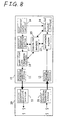
- Fig. 8 shows a position information transmitting /receiving device 10 for exchanging event generation information on a road together with another device 20 as an example of a device for executing the position information transmitting method according to the invention.
- the device 10 comprises a position information receiving portion 12 for receiving information including road shape data and event position data from a position information transmitting portion 21 of the device 20, a digital map data base 15 for storing digital map data, a map matching portion 13 for carrying out map matching by using the road shape data and the event position data to specify an event position on a digital map, a digital map display portion 14 for superposing and displaying the event position on the map, an event input portion 16 for inputting generated event information, a position information converting portion 17 for generating road shape data and event position data for transmitting the event information, a shape vector data deforming portion 18 for deforming the road shape data such that the mismatching is not generated on the receiving side, and a position information transmitting portion 11 for transmitting position information including the generated road shape data and event position data to a position information receiving portion 22 of the device 20.
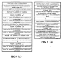
- Figs. 9(a) and 9(b) show an example of the position information transmitted from the position information transmitting portion 11, and Fig. 9(a) shows shape vector data string information for specifying a road section which includes the road shape data and Fig. 9(b) shows traffic information including relative distance data from a reference point provided in the road section to the event position.
- the position information converting portion 17 acquires coordinates (longitude / latitude) of nodes p1 to pn in the road section including the event generation position from the digital map data base 15 based on the event information input from the event input portion 16, generates road shape data (a shape vector data string), and furthermore, sets a reference point in the road section represented by the shape vector data string and generates traffic information including relative distance data from the reference point to the event generation position.
- the position information converting portion 17 selects the node p1 to be the start point for the map matching on the receiving side such that mismatching is not caused when generating the shape vector data string. This processing will be described in a first embodiment.
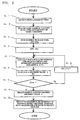
- Fig. 2 shows a procedure for selecting the node p1 by the position information converting portion 17. This procedure is executed in accordance with a program by a computer for implementing the function of the position information converting portion 17 based on the program. With reference to a view of Fig. 1, the procedure will be described.
- a solid line indicates a road on a digital map
- a white circle and a black circle indicate a node included in the shape of the road.
- a node to be a start point for map matching on the outside of an event generation section that is, a node to be the first node p1 in a shape vector data string
- the position information converting portion 17 selects a node in which mismatching is not generated on the receiving side from the black circle based on the procedure shown in Fig. 2.
- a point in which the receiving side makes an error with difficulty can be selected as the first node p1 in the shape vector data string to be the start point for the map matching.
- the shape vector data deforming portion 18 shifts an endpoing P in the object section to the position of P', thereby preventing the endpoint P from being mismatched as a point on the parallel track 1. If P' is too close to the parallel track 2, there is a possibility that the endpoint P might be mismatched as a point on the parallel track 2.
- the shape vector data deforming portion 18 selects the position of P' such that there is not such a possibility.
- Fig. 4 shows a processing procedure for the shape vector data deforming portion 18. This procedure is executed in accordance with a program by a computer for implementing the function of the shape vector data deforming portion 18 based on the program.
- ⁇ a predetermined coefficient of 0 ⁇ ⁇ ⁇ 1 and L0 represents a predetermined decision value of approximately 120 m.
- the entry and exit paths of an interchange intersect a main track at a small angle as shown in Fig. 6. Therefore, in the case in which sequential matching is carried out by using a shape vector data string representing an object section by the receiving side, mismatching is apt to be caused.
- the shape vector data deforming portion 18 shifts the position of a node in the object section to Pj+1', thereby preventing the mismatching. Also in this case, if a point of Pj+1' is too close to another connecting road, there is a possibility that the mismatching might be caused. Therefore, the shape vector data deforming portion 18 selects the position of Pj+1' such that there is not such a possibility.
- Fig. 7 shows the processing procedure of the shape vector data deforming portion 18 in this case. This procedure is executed in accordance with a program by a computer for implementing the function of the shape vector data deforming portion 18 based on the program.
- the transmitting side selects the matching start point and deforms the shape vector data as described in each embodiment, the receiving side can prevent the generation of the mismatching even if a sequential matching method or a shape matching method is to be employed.
Landscapes
- Engineering & Computer Science (AREA)
- Radar, Positioning & Navigation (AREA)
- Remote Sensing (AREA)
- Physics & Mathematics (AREA)
- General Physics & Mathematics (AREA)
- Theoretical Computer Science (AREA)
- Business, Economics & Management (AREA)
- Mathematical Physics (AREA)
- Automation & Control Theory (AREA)
- Educational Administration (AREA)
- Educational Technology (AREA)
- Navigation (AREA)
- Instructional Devices (AREA)
- Traffic Control Systems (AREA)
- Processing Or Creating Images (AREA)
- Radar Systems Or Details Thereof (AREA)
- Devices For Checking Fares Or Tickets At Control Points (AREA)
- Information Retrieval, Db Structures And Fs Structures Therefor (AREA)
Abstract
Description
At the
Claims (11)
- A method of transmitting position information of a digital map for transmitting a vector shape on the digital map from a transmitting side and specifying the vector shape on a digital map in a receiving side by map matching at the receiving side, the method comprising the steps of:wherein the steps of the selecting and transmitting are executed at the transmitting side.selecting a portion in which a plurality of candidate points are generated with difficulty during the map matching as an endpoint of the vector shape; andtransmitting the vector shape having the endpoint in the portion to the receiving side,
- A method of transmitting position information of a digital map for transmitting a vector shape on the digital map from a transmitting side and specifying the vector shape on a digital map in a receiving side by map matching at the receiving side, the method comprising the steps of:wherein the steps of setting, drawing, calculating, and selecting are executed at the receiving side.setting a plurality of candidate points for an endpoint of the vector shape,drawing a perpendicular on a vicinal vector shape from each of the candidate points,calculating a distance between an intersecting point and the candidate point and a difference in angle between an intercept azimuth of the intersecting point and an intercept azimuth of the candidate point, andselecting, for the endpoint of the vector shape, a candidate point determined by a decision value including the distance and the difference in angle between the intercept azimuths as elements,
- A method of transmitting position information of a digital map for transmitting a vector shape on the digital map from a transmitting side and specifying the vector shape on a digital map in a receiving side by map matching at the receiving side, the method comprising the steps of:wherein the steps of shifting and transmitting are executed at the transmitting side.shifting an endpoint of the vector shape to a portion in which a plurality of candidate points are generated with difficulty during map matching; andtransmitting the vector shape having an endpoint position deformed to the receiving side,
- A method of transmitting position information of a digital map for transmitting a vector shape on the digital map from a transmitting side and specifying the vector shape on a digital map in a receiving side by map matching at the receiving side, the method comprising the steps of:wherein the steps of drawing, calculating, selecting, and shifting are executed at the transmitting side.drawing a perpendicular on each of vicinal vector shapes from an endpoint of the vector shape;calculating a distance between an intersecting point and the endpoint and a difference in angle between an intercept azimuth of the intersecting point and an intercept azimuth of the endpoint;selecting the intersecting point based on a decision value including the distance and the difference in angle between the intercept azimuths as elements; andshifting the endpoint in an opposite direction to the intersecting point from the endpoint,
- A method of transmitting position information of a digital map for transmitting a vector shape on the digital map from a transmitting side and specifying the vector shape on a digital map in a receiving side by map matching at the receiving side, the method comprising the steps of:wherein the steps of deforming and transmitting are executed at the transmitting side.deforming an azimuth of the vector shape at an intersection in the middle of the vector shape in such a direction as to increase an angle formed by the vector shape and a connecting vector to be connected to the vector shape when the angle is small at the intersection; andtransmitting the vector shape having the azimuth deformed to the receiving side;
- The method of transmitting position information according to claim 5, further comprising the steps of:wherein the steps of extracting, calculating, deciding, and deforming are executed at the transmitting side.extracting intersection included in the vector shape,calculating an angle formed by the connecting vector to be connected to an intersection to be noted and an intersection provided in the vicinity thereof and the vector shape and a distance between the intersection to be noted and the intersection to be connected by the connecting vector,deciding whether or not the deformation is carried out based on a decision value including at least the angle and the distance as elements, anddeforming an azimuth of the vector shape at the intersection to be noted in such a direction as to increase the angle and deforms a position of the intersection to be noted in such a direction as to increase the distance when the deformation is to be carried out,
- The method of transmitting position information according to any of claims 3 to 6, further comprising the step of:wherein the step of the transmitting is executed at the transmitting side.transmitting, to the receiving side, information about a distance error or a direction error which is obtained in the deformation of the vector shape together with the vector shape,
- The method of transmitting position information according to claim 7, further comprising the step of ascertaining whether or not an error between the vector shape on a digital map in the receiving side specified by map matching and a received vector shape is included in a range of the error transmitted from the transmitting side,
wherein the step of ascertaining is executed at the receiving side. - A program of a transmitting device for transmitting a vector shape on a digital map which is specified through map matching by a receiving side,
wherein a computer is caused to execute:a procedure for setting a plurality of candidate points of an endpoint of the vector shape;a procedure for drawing a perpendicular on a vicinal vector shape from each of the candidate points, and calculating a distance between an intersecting point and the candidate point and a difference in angle between an intercept azimuth of the intersecting point and an intercept azimuth of the candidate point;a procedure for calculating a decision value including at least the distance and the difference in angle between the intercept azimuths as elements;a procedure for selecting a candidate point to be an endpoint of the vector shape based on the decision value; anda procedure for generating the vector shape including the selected candidate point as an endpoint. - A program of a transmitting device for transmitting a vector shape on a digital map which is specified through map matching by a receiving side,
wherein a computer is caused to execute the procedures of:drawing a perpendicular on each of vicinal vector shapes from an endpoint of the vector shape, and calculating a distance between an intersecting point and the endpoint and a difference in angle between an intercept azimuth of the intersecting point and an intercept azimuth of the endpoint;calculating a decision value including at least the distance and the difference in angle between the intercept azimuths as elements;selecting the intersecting point based on the decision value;shifting the endpoint in an opposite direction to the intersecting point from the endpoint;calculating the decision value in such a state that the endpoint is shifted;correcting a shifting distance of the endpoint based on the decision value in such a state that the endpoint is shifted; anda procedure for generating the vector shape including the shifted endpoint. - A program of a transmitting device for transmitting a vector shape on a digital map which is specified through map matching by a receiving side,
wherein a computer is caused to execute:a procedure for extracting an intersection included in the vector shape;a procedure for calculating an angle formed by a connecting vector to be connected to an intersection to be noted and an intersection provided in the vicinity thereof and the vector shape, and a distance between the intersection to be noted and the intersection connected by the connecting vector;a procedure for calculating a decision value including the angle and the distance as elements;a procedure for extracting the connecting vector based on the decision value;a procedure for deforming an azimuth of the vector shape at the intersection to be noted in such a direction as to increase an angle formed by the connecting vector thus extracted;a procedure for calculating the decision value in such a state that the angle is changed;a procedure for correcting an amount of change in the angle based on the decision value in such a state that the angle is changed; anda procedure for generating the vector shape having the angle changed.
Applications Claiming Priority (3)
| Application Number | Priority Date | Filing Date | Title |
|---|---|---|---|
| JP2001132610A JP4749594B2 (en) | 2001-04-27 | 2001-04-27 | Digital map location information transmission method |
| JP2001132610 | 2001-04-27 | ||
| PCT/JP2002/004168 WO2002088634A1 (en) | 2001-04-27 | 2002-04-25 | Digital map position information transfer method |
Publications (3)
| Publication Number | Publication Date |
|---|---|
| EP1306647A1 true EP1306647A1 (en) | 2003-05-02 |
| EP1306647A4 EP1306647A4 (en) | 2004-08-11 |
| EP1306647B1 EP1306647B1 (en) | 2006-06-07 |
Family
ID=18980598
Family Applications (1)
| Application Number | Title | Priority Date | Filing Date |
|---|---|---|---|
| EP02722799A Expired - Lifetime EP1306647B1 (en) | 2001-04-27 | 2002-04-25 | Digital map position information transfer method |
Country Status (9)
| Country | Link |
|---|---|
| US (3) | US6920392B2 (en) |
| EP (1) | EP1306647B1 (en) |
| JP (1) | JP4749594B2 (en) |
| KR (1) | KR100924128B1 (en) |
| CN (2) | CN1982847A (en) |
| AT (1) | ATE329227T1 (en) |
| CA (1) | CA2443262A1 (en) |
| DE (1) | DE60212036T2 (en) |
| WO (1) | WO2002088634A1 (en) |
Cited By (1)
| Publication number | Priority date | Publication date | Assignee | Title |
|---|---|---|---|---|
| DE102004042302B4 (en) * | 2003-08-28 | 2010-01-21 | Österreichisches Forschungs- und Prüfzentrum Arsenal Ges. m.b.H. | Method and arrangement for determining ways of road users |
Families Citing this family (32)
| Publication number | Priority date | Publication date | Assignee | Title |
|---|---|---|---|---|
| JP5041638B2 (en) * | 2000-12-08 | 2012-10-03 | パナソニック株式会社 | Method for transmitting location information of digital map and device used therefor |
| JP2004264326A (en) * | 2003-01-22 | 2004-09-24 | Matsushita Electric Ind Co Ltd | Shape information encoding method and apparatus, shape information decoding method and apparatus, and program |
| JP4543637B2 (en) * | 2003-08-26 | 2010-09-15 | 三菱電機株式会社 | Map information processing device |
| JP4318537B2 (en) * | 2003-11-19 | 2009-08-26 | パナソニック株式会社 | Map matching method and apparatus for implementing the same |
| US20050114020A1 (en) * | 2003-11-25 | 2005-05-26 | Nissan Motor Co., Ltd. | Navigation device, car navigation program, display device, and display control program for presenting information on branch destination |
| JP4509620B2 (en) * | 2004-03-24 | 2010-07-21 | クラリオン株式会社 | In-vehicle information terminal, summary map creation device, summary map display method |
| JP3875697B2 (en) * | 2004-05-06 | 2007-01-31 | 松下電器産業株式会社 | In-vehicle information processing equipment |
| JP2006071627A (en) * | 2004-08-04 | 2006-03-16 | Matsushita Electric Ind Co Ltd | POSITION INFORMATION TRANSMISSION DEVICE, POSITION INFORMATION RECEPTION DEVICE, POSITION INFORMATION TRANSMISSION METHOD, AND POSITION INFORMATION TRANSMISSION PROGRAM |
| JP2006171456A (en) * | 2004-12-16 | 2006-06-29 | Denso Corp | Map data accuracy evaluation method, map data accuracy evaluation device, map data accuracy evaluation program, and corrected map data generation method |
| CN101666655B (en) * | 2005-02-17 | 2012-02-29 | 松下电器产业株式会社 | Mobile history conversion device and mobile history conversion method |
| KR100674506B1 (en) * | 2005-06-01 | 2007-01-25 | 주식회사 현대오토넷 | Navigation system and method with one-touch map matching correction function |
| KR100716893B1 (en) * | 2005-07-26 | 2007-05-09 | 주식회사 현대오토넷 | Unregistered road registration device and method in vehicle navigation system |
| CN101410873B (en) * | 2005-07-26 | 2012-07-04 | 德卡尔塔公司 | Summarize features in digital maps |
| JP2008014666A (en) * | 2006-07-03 | 2008-01-24 | Nec Corp | Link setting system suitable for map-matching, its method, and program |
| JP4858197B2 (en) * | 2007-01-31 | 2012-01-18 | ソニー株式会社 | Information processing apparatus, image display apparatus, information processing system, information processing method, and program |
| US8170793B2 (en) * | 2007-06-29 | 2012-05-01 | Tele Atlas North America, Inc. | System and method for determining routing point placement for aiding in encoding and decoding a path |
| US8243060B2 (en) * | 2007-08-06 | 2012-08-14 | Decarta Inc. | Generalization of features in a digital map using round number coordinates |
| JP4606445B2 (en) * | 2007-08-27 | 2011-01-05 | パナソニック株式会社 | Map matching method and apparatus for implementing the same |
| US7708651B2 (en) | 2007-11-24 | 2010-05-04 | Hyung In Shin | Golf putter with an adjustable handle and a shaft that rotates about the handle and method for using the same |
| US8775063B2 (en) * | 2009-01-26 | 2014-07-08 | GM Global Technology Operations LLC | System and method of lane path estimation using sensor fusion |
| CN101620802B (en) * | 2009-08-05 | 2011-06-01 | 北京四维图新科技股份有限公司 | Method and device for checking electronic map |
| CN101826274B (en) * | 2010-04-16 | 2012-02-08 | 重庆大学 | Vector traffic numerical map correction method based on floating car data |
| US8718932B1 (en) * | 2011-06-01 | 2014-05-06 | Google Inc. | Snapping GPS tracks to road segments |
| US9965140B2 (en) | 2011-12-26 | 2018-05-08 | TrackThings LLC | Method and apparatus of a marking objects in images displayed on a portable unit |
| US8836698B2 (en) | 2011-12-26 | 2014-09-16 | TrackThings LLC | Method and apparatus for identifying a 3-D object from a 2-D display of a portable unit |
| US8532919B2 (en) * | 2011-12-26 | 2013-09-10 | TrackThings LLC | Method and apparatus of physically moving a portable unit to view an image of a stationary map |
| US9026896B2 (en) | 2011-12-26 | 2015-05-05 | TrackThings LLC | Method and apparatus of physically moving a portable unit to view composite webpages of different websites |
| DE102013219995B4 (en) | 2012-10-08 | 2024-07-04 | International Business Machines Corporation | Mapping infrastructure layouts between mismatched data sets |
| US8996197B2 (en) * | 2013-06-20 | 2015-03-31 | Ford Global Technologies, Llc | Lane monitoring with electronic horizon |
| FR3019361B1 (en) * | 2014-03-28 | 2017-05-19 | Airbus Helicopters | METHOD FOR DETECTING AND VISUALIZING ARTIFICIAL OBSTACLES IN A ROTARY WING AIRCRAFT |
| CN106855415B (en) * | 2017-01-09 | 2020-03-03 | 北京京东尚科信息技术有限公司 | Map matching method and system |
| CN115602041B (en) * | 2021-07-09 | 2024-04-09 | 华为技术有限公司 | Information generation method and device, information use method and device |
Family Cites Families (156)
| Publication number | Priority date | Publication date | Assignee | Title |
|---|---|---|---|---|
| US4196474A (en) * | 1974-02-11 | 1980-04-01 | The Johns Hopkins University | Information display method and apparatus for air traffic control |
| DE2431630C2 (en) * | 1974-07-02 | 1985-06-27 | Robert Bosch Gmbh, 7000 Stuttgart | Optoelectronic transducer |
| DE2631543A1 (en) * | 1976-07-14 | 1978-01-19 | Blaupunkt Werke Gmbh | GUIDANCE SYSTEM FOR MOTOR VEHICLES |
| US4151656A (en) * | 1977-09-12 | 1979-05-01 | Eastman Kodak Company | Manually manipulatable gyroscope-stabilized indicating apparatus and method for its use |
| DE3334093A1 (en) * | 1983-09-21 | 1985-04-11 | Robert Bosch Gmbh, 7000 Stuttgart | METHOD AND CIRCUIT FOR DETERMINING THE OPTIMUM OPERATIONAL GEARBOX OF A MOTOR VEHICLE DRIVE |
| DE3345712A1 (en) * | 1983-12-17 | 1985-06-27 | Robert Bosch Gmbh, 7000 Stuttgart | MAGNETOMETER WITH TIME ENCLOSURE FOR MEASURING MAGNETIC FIELDS |
| DE3345818A1 (en) * | 1983-12-17 | 1985-06-27 | Robert Bosch Gmbh, 7000 Stuttgart | METHOD FOR DETERMINING INTERFERENCE FIELDS IN VEHICLES WITH AN ELECTRONIC COMPASS |
| DE3422490A1 (en) * | 1984-06-16 | 1985-12-19 | Robert Bosch Gmbh, 7000 Stuttgart | METHOD FOR CORRECTING ANGLE ERRORS IN AN ELECTRONIC COMPASS IN VEHICLES |
| DE3422491A1 (en) * | 1984-06-16 | 1985-12-19 | Robert Bosch Gmbh, 7000 Stuttgart | METHOD FOR DETERMINING THE DIRECTION OF A VEHICLE WITH AN ELECTRONIC COMPASS |
| DE3532016A1 (en) * | 1985-09-07 | 1987-03-19 | Bosch Gmbh Robert | DEVICE FOR MEASURING DISTANCE AND DIRECTION OF DESTINATIONS ON ROAD MAPS |
| DE3532768A1 (en) * | 1985-09-13 | 1987-03-19 | Bosch Gmbh Robert | CIRCUIT ARRANGEMENT FOR ADDITION, STORAGE AND PLAYBACK OF ELECTRICAL NUMBER |
| CA1295737C (en) | 1986-03-14 | 1992-02-11 | Akira Ichikawa | Apparatus for displaying travel path |
| EP0261404B1 (en) | 1986-09-25 | 1991-02-13 | Siemens Aktiengesellschaft | Navigation device for a vehicle |
| JPH07107548B2 (en) | 1986-10-13 | 1995-11-15 | 株式会社日立製作所 | Positioning method using artificial satellites |
| US4807127A (en) | 1986-12-10 | 1989-02-21 | Sumitomo Electric Industries, Ltd. | Vehicle location detecting system |
| JPS63150618A (en) | 1986-12-15 | 1988-06-23 | Honda Motor Co Ltd | Driving route display device |
| DE3644683A1 (en) * | 1986-12-30 | 1988-07-14 | Bosch Gmbh Robert | NAVIGATION METHOD FOR VEHICLES WITH ELECTRONIC COMPASS |
| DE3644681A1 (en) * | 1986-12-30 | 1988-07-14 | Bosch Gmbh Robert | NAVIGATION METHOD FOR VEHICLES WITH ELECTRONIC COMPASS |
| DE3715007A1 (en) | 1987-05-06 | 1988-11-17 | Bosch Gmbh Robert | METHOD AND DEVICE FOR DETERMINING THE COURSE OF A LAND VEHICLE |
| DE3719017A1 (en) | 1987-06-06 | 1988-12-15 | Bosch Gmbh Robert | METHOD AND DEVICE FOR DETERMINING A DRIVING ROUTE BETWEEN A START POINT AND A DESTINATION POINT |
| CA1326273C (en) | 1987-08-07 | 1994-01-18 | Akira Iihoshi | Apparatus for displaying travel path |
| DE3737972A1 (en) | 1987-11-07 | 1989-05-24 | Messerschmitt Boelkow Blohm | HELMET LOCATION DEVICE |
| US5184123A (en) * | 1988-03-03 | 1993-02-02 | Robert Bosch Gmbh | Method of and arrangement for representing travel guiding information |
| DE3810177C2 (en) * | 1988-03-25 | 1999-06-17 | Bosch Gmbh Robert | Radio receivers, in particular vehicle receivers |
| JPH07119617B2 (en) | 1988-07-05 | 1995-12-20 | マツダ株式会社 | Vehicle navigation system |
| EP0380673A4 (en) | 1988-08-11 | 1992-09-09 | Aisin Aw Co., Ltd. | Navigation system |
| JPH0758201B2 (en) | 1989-08-01 | 1995-06-21 | 本田技研工業株式会社 | Current position display of mobile |
| US5193214A (en) * | 1989-12-29 | 1993-03-09 | Robert Bosch Gmbh | Vehicular radio receiver with standard traffic problem database |
| US5095532A (en) * | 1989-12-29 | 1992-03-10 | Robert Bosch Gmbh | Method and apparatus for route-selective reproduction of broadcast traffic announcements |
| DE4008460A1 (en) * | 1990-03-16 | 1991-09-19 | Bosch Gmbh Robert | NAVIGATION SYSTEM |
| US5279040A (en) * | 1990-05-18 | 1994-01-18 | Robert Bosch Gmbh | Fluid-based acceleration and tilt sensor |
| US5182555A (en) * | 1990-07-26 | 1993-01-26 | Farradyne Systems, Inc. | Cell messaging process for an in-vehicle traffic congestion information system |
| US5214757A (en) | 1990-08-07 | 1993-05-25 | Georesearch, Inc. | Interactive automated mapping system |
| US5177685A (en) * | 1990-08-09 | 1993-01-05 | Massachusetts Institute Of Technology | Automobile navigation system using real time spoken driving instructions |
| NL9001810A (en) | 1990-08-13 | 1992-03-02 | Philips Nv | METHOD FOR DETERMINING THE POSITION OF A VEHICLE, DEVICE FOR DETERMINING THE POSITION OF A VEHICLE AND VEHICLE PROVIDED WITH THE DEVICE. |
| FR2667423B1 (en) | 1990-09-28 | 1995-05-24 | Sagem | AUTOMOBILE NAVIGATION AID RECEIVER. |
| DE4035370A1 (en) * | 1990-11-07 | 1992-05-14 | Bosch Gmbh Robert | METHOD FOR DETERMINING THE LOCATION OF A LANDING VEHICLE |
| DE4039887A1 (en) * | 1990-12-13 | 1992-06-17 | Bosch Gmbh Robert | VEHICLE GUIDE AND GUIDE SYSTEM |
| US5311195A (en) | 1991-08-30 | 1994-05-10 | Etak, Inc. | Combined relative and absolute positioning method and apparatus |
| DE4129085A1 (en) * | 1991-09-02 | 1993-03-04 | Bosch Gmbh Robert | OPTICAL SENSOR FOR ROTATIONAL MOVEMENTS |
| US6107941A (en) * | 1991-10-09 | 2000-08-22 | R. D. Jones, Right Of Way, Inc. | Traffic control system and kit |
| US5283575A (en) * | 1991-11-08 | 1994-02-01 | Zexel Corporation | System and method for locating a travelling vehicle |
| US5396429A (en) * | 1992-06-30 | 1995-03-07 | Hanchett; Byron L. | Traffic condition information system |
| DE4230294A1 (en) * | 1992-09-10 | 1994-03-17 | Bosch Gmbh Robert | Procedure for selecting route-relevant messages on RDS radios |
| JP3221746B2 (en) | 1992-10-14 | 2001-10-22 | パイオニア株式会社 | Navigation device |
| JP3157923B2 (en) | 1992-10-20 | 2001-04-23 | パイオニア株式会社 | Distance error correction method for navigation device |
| US5332180A (en) * | 1992-12-28 | 1994-07-26 | Union Switch & Signal Inc. | Traffic control system utilizing on-board vehicle information measurement apparatus |
| US6208268B1 (en) * | 1993-04-30 | 2001-03-27 | The United States Of America As Represented By The Secretary Of The Navy | Vehicle presence, speed and length detecting system and roadway installed detector therefor |
| JP3103247B2 (en) | 1993-05-24 | 2000-10-30 | アルパイン株式会社 | Running direction calculation method |
| DE4318109A1 (en) * | 1993-06-01 | 1994-12-08 | Bosch Gmbh Robert | Method and device for carrying out a wireless data exchange between a base station and moving objects |
| DE4318108C1 (en) * | 1993-06-01 | 1995-01-05 | Bosch Gmbh Robert | Method for carrying out a wireless data exchange between a base station and transceivers |
| JPH06347278A (en) * | 1993-06-10 | 1994-12-20 | Alpine Electron Inc | Existent link detection method of vehicle |
| US5504482A (en) * | 1993-06-11 | 1996-04-02 | Rockwell International Corporation | Automobile navigation guidance, control and safety system |
| US5488559A (en) * | 1993-08-02 | 1996-01-30 | Motorola, Inc. | Map-matching with competing sensory positions |
| US5515042A (en) * | 1993-08-23 | 1996-05-07 | Nelson; Lorry | Traffic enforcement device |
| DE4332945A1 (en) | 1993-09-28 | 1995-03-30 | Bosch Gmbh Robert | Positioning and navigation device with satellite support |
| DE4333357A1 (en) * | 1993-09-30 | 1995-04-06 | Bosch Gmbh Robert | Parking aid with wheel sensor |
| US5416711A (en) * | 1993-10-18 | 1995-05-16 | Grumman Aerospace Corporation | Infra-red sensor system for intelligent vehicle highway systems |
| US5793310A (en) * | 1994-02-04 | 1998-08-11 | Nissan Motor Co., Ltd. | Portable or vehicular navigating apparatus and method capable of displaying bird's eye view |
| DE4410895B4 (en) * | 1994-03-29 | 2004-11-25 | Robert Bosch Gmbh | Method and device for concealed installation of an ultrasonic sensor in an outer part of a motor vehicle |
| DE4415993A1 (en) | 1994-05-06 | 1995-11-09 | Bosch Gmbh Robert | Correction method and navigation system for the coupling location of a motor vehicle |
| DE69526410T2 (en) | 1994-07-04 | 2003-01-16 | Siemens Ag | METHOD FOR DETERMINING A DIRECTION CHANGE DURING VEHICLE NAVIGATION, DEVICE FOR IMPLEMENTING THIS METHOD, AND VEHICLE WITH SUCH A DEVICE |
| KR960705190A (en) * | 1994-08-08 | 1996-10-09 | 요트.게.아. 롤페즈 | A navigation device for a land vehicle with means for generating a multi-element anticipatory speech message, and a vehicle comprising such device |
| JP2674521B2 (en) * | 1994-09-21 | 1997-11-12 | 日本電気株式会社 | Mobile object guidance device |
| DE4433982C1 (en) * | 1994-09-23 | 1995-10-19 | Bosch Gmbh Robert | Device for finding an available parking space or car park |
| US5581259A (en) * | 1994-11-03 | 1996-12-03 | Trimble Navigation Limited | Life for old maps |
| US5659476A (en) * | 1994-12-22 | 1997-08-19 | Motorola Inc. | Land vehicle navigation apparatus and method for planning a recovery route |
| EP0815547B2 (en) * | 1995-03-23 | 2006-08-30 | T-Mobile Deutschland GmbH | Method and system for determining dynamic traffic information |
| JP3578511B2 (en) | 1995-04-21 | 2004-10-20 | 株式会社ザナヴィ・インフォマティクス | Current position calculation device |
| JP3578512B2 (en) | 1995-04-21 | 2004-10-20 | 株式会社ザナヴィ・インフォマティクス | Current position calculating device and distance coefficient correcting method thereof |
| DE19516477A1 (en) * | 1995-05-05 | 1996-11-07 | Bosch Gmbh Robert | Device for preparing and outputting information for a driver |
| JP3545839B2 (en) | 1995-06-09 | 2004-07-21 | 株式会社ザナヴィ・インフォマティクス | Current position calculation device |
| JPH0914984A (en) * | 1995-06-28 | 1997-01-17 | Aisin Aw Co Ltd | Navigation device for vehicle |
| KR960042490A (en) | 1995-11-09 | 1996-12-21 | 모리 하루오 | Vehicle navigation device and recording medium therefor |
| US5933100A (en) * | 1995-12-27 | 1999-08-03 | Mitsubishi Electric Information Technology Center America, Inc. | Automobile navigation system with dynamic traffic data |
| US5862511A (en) | 1995-12-28 | 1999-01-19 | Magellan Dis, Inc. | Vehicle navigation system and method |
| US5745865A (en) * | 1995-12-29 | 1998-04-28 | Lsi Logic Corporation | Traffic control system utilizing cellular telephone system |
| DE19616038A1 (en) * | 1996-04-23 | 1997-10-30 | Bosch Gmbh Robert | Method and measuring device for determining the position of an object |
| JP3406144B2 (en) * | 1996-04-24 | 2003-05-12 | 株式会社デンソー | Route guidance device for vehicles |
| EP0810570B1 (en) * | 1996-05-31 | 2003-10-15 | Xanavi Informatics Corporation | Navigation system indicating distance to traffic jams |
| US6111521A (en) * | 1996-09-18 | 2000-08-29 | Mannesmann Vdo Ag | Apparatus for supplying traffic-related information |
| JP3143927B2 (en) | 1996-09-20 | 2001-03-07 | トヨタ自動車株式会社 | Position information providing system and device |
| DE19645209B4 (en) | 1996-11-02 | 2005-07-28 | Robert Bosch Gmbh | Locating device for a motor vehicle with a satellite receiver and locating method |
| US5948043A (en) | 1996-11-08 | 1999-09-07 | Etak, Inc. | Navigation system using GPS data |
| WO1998027530A1 (en) | 1996-12-16 | 1998-06-25 | Mannesmann Ag | Process for transmitting route information concerning the recommended route of a vehicle in a road network between a traffic information centre and a terminal mounted in a vehicle, terminal and traffic information centre |
| EP0944895B1 (en) * | 1996-12-16 | 2002-01-16 | MANNESMANN Aktiengesellschaft | Process for transmitting route information which concerns a route of a vehicle in a road network between a traffic information centre and a terminal in a vehicle, traffic information centre and terminal |
| DE19653021A1 (en) * | 1996-12-19 | 1998-06-25 | Bosch Gmbh Robert | Device for determining a rotation rate |
| US6230100B1 (en) | 1997-01-31 | 2001-05-08 | Motorola, Inc. | Method and apparatus for differential scale factor calibration in differential odometry systems integrated with GPS |
| DE19808111B4 (en) * | 1997-02-28 | 2007-04-05 | Aisin AW Co., Ltd., Anjo | Car navigation system |
| EP0863381B1 (en) | 1997-03-07 | 2004-06-02 | Pioneer Electronic Corporation | Navigation apparatus |
| JPH10281790A (en) * | 1997-04-08 | 1998-10-23 | Aisin Aw Co Ltd | Route search device, navigation apparatus and medium on which computer program for navigation processing is stored |
| DE19714600B4 (en) | 1997-04-09 | 2004-05-27 | Robert Bosch Gmbh | Locating device for vehicles |
| US6021371A (en) * | 1997-04-16 | 2000-02-01 | Trimble Navigation Limited | Communication and navigation system incorporating position determination |
| JPH10307037A (en) | 1997-05-02 | 1998-11-17 | Pioneer Electron Corp | Navigator |
| AU7703598A (en) * | 1997-05-30 | 1998-12-30 | David S. Booth | Generation and delivery of travel-related, location-sensitive information |
| EP0899703B1 (en) * | 1997-08-25 | 2002-10-30 | Texas Instruments France | A navigational system |
| DE19737256B4 (en) | 1997-08-27 | 2005-02-24 | Robert Bosch Gmbh | Vehicle guidance and guidance system |
| DE19741033A1 (en) * | 1997-09-18 | 1999-03-25 | Bosch Gmbh Robert | Transmission of traffic information for the driver of a vehicle |
| DE19743568A1 (en) * | 1997-10-02 | 1999-04-08 | Bosch Gmbh Robert | Angle measuring device |
| DE19748127A1 (en) | 1997-10-31 | 1999-05-06 | Bosch Gmbh Robert | Navigation device for motor vehicles |
| JP3547300B2 (en) * | 1997-12-04 | 2004-07-28 | 株式会社日立製作所 | Information exchange system |
| JP3555466B2 (en) * | 1998-10-09 | 2004-08-18 | 株式会社エクォス・リサーチ | Navigation center device and navigation device |
| JPH11214068A (en) | 1998-01-21 | 1999-08-06 | Japan Aviation Electronics Ind Ltd | Multi-block connector |
| DE19803662C2 (en) | 1998-01-30 | 1999-12-02 | Siemens Ag | Navigation device and method for determining position using dead reckoning |
| JP3269446B2 (en) * | 1998-02-13 | 2002-03-25 | 日産自動車株式会社 | Curve detection device |
| JPH11242166A (en) | 1998-02-26 | 1999-09-07 | Canon Inc | Eyepiece, finder optical system and optical apparatus having the same |
| US6038559A (en) | 1998-03-16 | 2000-03-14 | Navigation Technologies Corporation | Segment aggregation in a geographic database and methods for use thereof in a navigation application |
| US6192314B1 (en) * | 1998-03-25 | 2001-02-20 | Navigation Technologies Corp. | Method and system for route calculation in a navigation application |
| US6108603A (en) | 1998-04-07 | 2000-08-22 | Magellan Dis, Inc. | Navigation system using position network for map matching |
| DE19818473C2 (en) | 1998-04-24 | 2000-03-30 | Siemens Ag | Method for determining the position of a vehicle |
| EP1020832A1 (en) | 1998-04-28 | 2000-07-19 | Robert Bosch Gmbh | Method for generating a location reference instance within a digital map |
| DE19823123C2 (en) * | 1998-05-23 | 2000-05-25 | Opel Adam Ag | Method for operating a navigation system for motor vehicles |
| JP4026250B2 (en) | 1998-11-20 | 2007-12-26 | 株式会社エクォス・リサーチ | Navigation system and method |
| DE19835051A1 (en) | 1998-08-04 | 2000-02-10 | Bosch Gmbh Robert | Device for coding and decoding locations |
| DE19836485A1 (en) * | 1998-08-12 | 2000-02-17 | Bosch Gmbh Robert | Method for determining a route from a starting point to a destination on a route network |
| US6064319A (en) * | 1998-10-22 | 2000-05-16 | Matta; David M. | Method and system for regulating switching of a traffic light |
| DE19850066B4 (en) * | 1998-10-30 | 2008-05-21 | Robert Bosch Gmbh | Micromechanical tilt sensor |
| EP2009608A3 (en) * | 1998-11-23 | 2009-09-23 | Integrated Transport Information Services Limited | Instantaneous traffic monitoring system |
| US6333703B1 (en) * | 1998-11-24 | 2001-12-25 | International Business Machines Corporation | Automated traffic mapping using sampling and analysis |
| DE19856478C1 (en) * | 1998-12-02 | 2000-06-21 | Ddg Ges Fuer Verkehrsdaten Mbh | Parking space detection |
| JP3607516B2 (en) | 1999-01-20 | 2005-01-05 | 松下電器産業株式会社 | Mobile map matching device |
| DE19903909A1 (en) * | 1999-02-01 | 2000-08-03 | Delphi 2 Creative Tech Gmbh | Method and device for obtaining relevant traffic information and for dynamic route optimization |
| US6223125B1 (en) * | 1999-02-05 | 2001-04-24 | Brett O. Hall | Collision avoidance system |
| SE520822C2 (en) | 1999-02-17 | 2003-09-02 | Telia Ab | System for presenting user-adapted position-dependent information on terminal equipment |
| US6236336B1 (en) * | 1999-02-24 | 2001-05-22 | Cobra Electronics Corp. | Traffic information warning system with single modulated carrier |
| JP4060974B2 (en) | 1999-02-25 | 2008-03-12 | 株式会社ザナヴィ・インフォマティクス | Route guidance device |
| JP2000258176A (en) * | 1999-03-10 | 2000-09-22 | Matsushita Electric Ind Co Ltd | Dynamic map data update system |
| DE19915212A1 (en) | 1999-04-03 | 2000-10-05 | Bosch Gmbh Robert | Method and device for determining the position of a vehicle |
| US6381536B1 (en) * | 1999-06-21 | 2002-04-30 | Nissan Motor Co., Ltd. | Apparatus for generating road information from stored digital map database |
| US6587601B1 (en) | 1999-06-29 | 2003-07-01 | Sarnoff Corporation | Method and apparatus for performing geo-spatial registration using a Euclidean representation |
| JP3225958B2 (en) | 1999-12-27 | 2001-11-05 | 株式会社エクォス・リサーチ | Navigation method, route providing device, route guidance device |
| JP3568108B2 (en) | 1999-07-28 | 2004-09-22 | 松下電器産業株式会社 | Method for transmitting location information of digital map and apparatus for implementing the method |
| JP3481168B2 (en) * | 1999-08-27 | 2003-12-22 | 松下電器産業株式会社 | Digital map location information transmission method |
| DE19942522A1 (en) | 1999-09-07 | 2001-03-08 | Bosch Gmbh Robert | Method for coding and decoding objects related to a traffic network |
| US6687611B1 (en) | 1999-09-07 | 2004-02-03 | Robert Bosch Gmbh | Method for coding and decoding objects in a road traffic network |
| US6212473B1 (en) * | 1999-09-20 | 2001-04-03 | Ford Global Technologies, Inc. | Vehicle navigation system having inferred user preferences |
| US6490519B1 (en) * | 1999-09-27 | 2002-12-03 | Decell, Inc. | Traffic monitoring system and methods for traffic monitoring and route guidance useful therewith |
| US6188957B1 (en) * | 1999-10-04 | 2001-02-13 | Navigation Technologies Corporation | Method and system for providing bicycle information with a navigation system |
| US6674434B1 (en) | 1999-10-25 | 2004-01-06 | Navigation Technologies Corp. | Method and system for automatic generation of shape and curvature data for a geographic database |
| JP2003514238A (en) * | 1999-11-11 | 2003-04-15 | フオルクスヴアーゲン アクチエンゲゼルシヤフト | Method of representing and forming a road network and a road network |
| JP4479028B2 (en) * | 1999-11-18 | 2010-06-09 | 株式会社エクォス・リサーチ | Communication type in-vehicle information processing apparatus and communication type information center |
| JP3589124B2 (en) | 1999-11-18 | 2004-11-17 | トヨタ自動車株式会社 | Navigation device |
| DE19963765A1 (en) | 1999-12-30 | 2001-07-05 | Bosch Gmbh Robert | Method for operating a navigation system |
| DE19963764A1 (en) * | 1999-12-30 | 2001-07-05 | Bosch Gmbh Robert | Method, control panel, navigation system and interface for displaying sections of a digital map base |
| DE19963766A1 (en) | 1999-12-30 | 2001-07-05 | Bosch Gmbh Robert | Method for operating a navigation system |
| DE10004163A1 (en) | 2000-02-01 | 2001-08-02 | Bosch Gmbh Robert | Navigation system and method for customizing a navigation system |
| JP3471003B2 (en) | 2000-02-02 | 2003-11-25 | 松下電器産業株式会社 | Intersection display method, map display device therefor, and recording medium |
| DE60119403T2 (en) * | 2000-02-14 | 2007-04-19 | Matsushita Electric Industrial Co., Ltd., Kadoma | Apparatus and method for changing card information |
| DE10016674A1 (en) | 2000-04-04 | 2001-10-18 | Bosch Gmbh Robert | Method for outputting data in a vehicle and driver information device |
| JP3816299B2 (en) | 2000-04-28 | 2006-08-30 | パイオニア株式会社 | Navigation system |
| DE10021373A1 (en) | 2000-05-02 | 2001-11-08 | Siemens Ag | Positioning method and navigation device |
| DE10030896A1 (en) | 2000-06-23 | 2002-01-03 | Bosch Gmbh Robert | Digital road map for automobile navigation system has road sections defined by point coordinates with incline gradient of each road section provided |
| DE10033193A1 (en) | 2000-07-07 | 2002-01-17 | Bosch Gmbh Robert | Method and arrangement for coding, decoding and / or for transmitting location information |
| DE10039235C2 (en) | 2000-08-11 | 2003-01-30 | Bosch Gmbh Robert | Procedure for displaying a route |
| EP1311802A1 (en) | 2000-08-24 | 2003-05-21 | Siemens Aktiengesellschaft | Method for obtaining a card representation and navigation device |
| JP4663136B2 (en) * | 2001-01-29 | 2011-03-30 | パナソニック株式会社 | Method and apparatus for transmitting location information of digital map |
-
2001
- 2001-04-27 JP JP2001132610A patent/JP4749594B2/en not_active Expired - Lifetime
-
2002
- 2002-04-25 CA CA002443262A patent/CA2443262A1/en not_active Abandoned
- 2002-04-25 US US10/169,704 patent/US6920392B2/en not_active Expired - Lifetime
- 2002-04-25 CN CNA2006101484708A patent/CN1982847A/en active Pending
- 2002-04-25 AT AT02722799T patent/ATE329227T1/en not_active IP Right Cessation
- 2002-04-25 CN CNB028089316A patent/CN1294405C/en not_active Expired - Lifetime
- 2002-04-25 EP EP02722799A patent/EP1306647B1/en not_active Expired - Lifetime
- 2002-04-25 DE DE60212036T patent/DE60212036T2/en not_active Expired - Lifetime
- 2002-04-25 KR KR1020037013842A patent/KR100924128B1/en not_active Expired - Lifetime
- 2002-04-25 WO PCT/JP2002/004168 patent/WO2002088634A1/en not_active Ceased
-
2004
- 2004-12-08 US US11/007,895 patent/US20050131632A1/en not_active Abandoned
-
2007
- 2007-03-12 US US11/684,698 patent/US9177487B2/en not_active Expired - Fee Related
Cited By (1)
| Publication number | Priority date | Publication date | Assignee | Title |
|---|---|---|---|---|
| DE102004042302B4 (en) * | 2003-08-28 | 2010-01-21 | Österreichisches Forschungs- und Prüfzentrum Arsenal Ges. m.b.H. | Method and arrangement for determining ways of road users |
Also Published As
| Publication number | Publication date |
|---|---|
| JP4749594B2 (en) | 2011-08-17 |
| JP2002328032A (en) | 2002-11-15 |
| CN1294405C (en) | 2007-01-10 |
| CA2443262A1 (en) | 2002-11-07 |
| EP1306647A4 (en) | 2004-08-11 |
| KR20040015123A (en) | 2004-02-18 |
| CN1982847A (en) | 2007-06-20 |
| EP1306647B1 (en) | 2006-06-07 |
| US20050131632A1 (en) | 2005-06-16 |
| KR100924128B1 (en) | 2009-10-29 |
| WO2002088634A1 (en) | 2002-11-07 |
| ATE329227T1 (en) | 2006-06-15 |
| CN1505749A (en) | 2004-06-16 |
| DE60212036T2 (en) | 2006-12-14 |
| DE60212036D1 (en) | 2006-07-20 |
| US6920392B2 (en) | 2005-07-19 |
| US9177487B2 (en) | 2015-11-03 |
| US20070150181A1 (en) | 2007-06-28 |
| US20030109984A1 (en) | 2003-06-12 |
Similar Documents
| Publication | Publication Date | Title |
|---|---|---|
| EP1306647A1 (en) | Digital map position information transfer method | |
| KR100895803B1 (en) | Method and device for transmitting location information of digital map | |
| JP5041638B2 (en) | Method for transmitting location information of digital map and device used therefor | |
| EP1584897B1 (en) | Navigation apparatus, and data processing method and computer program used therewith | |
| US20050131642A1 (en) | Relative position information correction device, relative position information correction method, relative osition information correction program, shape vector generation device, shape vector generation method, and shape vector generation program | |
| JP4991002B2 (en) | Method and apparatus for transmitting location information of digital map | |
| JP5328944B2 (en) | Method and apparatus for transmitting location information of digital map | |
| JP2001084357A (en) | How to extract road width data | |
| JP2002328027A (en) | Digital map location information transmission method | |
| JP2002328034A (en) | Digital map location information transmission method and device for implementing the method | |
| JP2007072011A (en) | Device for creating road network data, method for creating road network data, and data structure of road network data | |
| JP2005004228A (en) | Digital map location information transmission method | |
| JP2002328599A (en) | Digital map location information transmission method |
Legal Events
| Date | Code | Title | Description |
|---|---|---|---|
| PUAI | Public reference made under article 153(3) epc to a published international application that has entered the european phase |
Free format text: ORIGINAL CODE: 0009012 |
|
| 17P | Request for examination filed |
Effective date: 20020711 |
|
| AK | Designated contracting states |
Designated state(s): AT BE CH CY DE DK ES FI FR GB GR IE IT LI LU MC NL PT SE TR |
|
| AX | Request for extension of the european patent |
Extension state: AL LT LV MK RO SI |
|
| A4 | Supplementary search report drawn up and despatched |
Effective date: 20040624 |
|
| 17Q | First examination report despatched |
Effective date: 20040816 |
|
| GRAP | Despatch of communication of intention to grant a patent |
Free format text: ORIGINAL CODE: EPIDOSNIGR1 |
|
| GRAS | Grant fee paid |
Free format text: ORIGINAL CODE: EPIDOSNIGR3 |
|
| GRAA | (expected) grant |
Free format text: ORIGINAL CODE: 0009210 |
|
| AK | Designated contracting states |
Kind code of ref document: B1 Designated state(s): AT BE CH CY DE DK ES FI FR GB GR IE IT LI LU MC NL PT SE TR |
|
| PG25 | Lapsed in a contracting state [announced via postgrant information from national office to epo] |
Ref country code: IT Free format text: LAPSE BECAUSE OF FAILURE TO SUBMIT A TRANSLATION OF THE DESCRIPTION OR TO PAY THE FEE WITHIN THE PRESCRIBED TIME-LIMIT;WARNING: LAPSES OF ITALIAN PATENTS WITH EFFECTIVE DATE BEFORE 2007 MAY HAVE OCCURRED AT ANY TIME BEFORE 2007. THE CORRECT EFFECTIVE DATE MAY BE DIFFERENT FROM THE ONE RECORDED. Effective date: 20060607 Ref country code: CH Free format text: LAPSE BECAUSE OF FAILURE TO SUBMIT A TRANSLATION OF THE DESCRIPTION OR TO PAY THE FEE WITHIN THE PRESCRIBED TIME-LIMIT Effective date: 20060607 Ref country code: FI Free format text: LAPSE BECAUSE OF FAILURE TO SUBMIT A TRANSLATION OF THE DESCRIPTION OR TO PAY THE FEE WITHIN THE PRESCRIBED TIME-LIMIT Effective date: 20060607 Ref country code: AT Free format text: LAPSE BECAUSE OF FAILURE TO SUBMIT A TRANSLATION OF THE DESCRIPTION OR TO PAY THE FEE WITHIN THE PRESCRIBED TIME-LIMIT Effective date: 20060607 Ref country code: BE Free format text: LAPSE BECAUSE OF FAILURE TO SUBMIT A TRANSLATION OF THE DESCRIPTION OR TO PAY THE FEE WITHIN THE PRESCRIBED TIME-LIMIT Effective date: 20060607 Ref country code: NL Free format text: LAPSE BECAUSE OF FAILURE TO SUBMIT A TRANSLATION OF THE DESCRIPTION OR TO PAY THE FEE WITHIN THE PRESCRIBED TIME-LIMIT Effective date: 20060607 Ref country code: LI Free format text: LAPSE BECAUSE OF FAILURE TO SUBMIT A TRANSLATION OF THE DESCRIPTION OR TO PAY THE FEE WITHIN THE PRESCRIBED TIME-LIMIT Effective date: 20060607 |
|
| REG | Reference to a national code |
Ref country code: GB Ref legal event code: FG4D |
|
| REG | Reference to a national code |
Ref country code: CH Ref legal event code: EP |
|
| REG | Reference to a national code |
Ref country code: IE Ref legal event code: FG4D |
|
| REF | Corresponds to: |
Ref document number: 60212036 Country of ref document: DE Date of ref document: 20060720 Kind code of ref document: P |
|
| PG25 | Lapsed in a contracting state [announced via postgrant information from national office to epo] |
Ref country code: DK Free format text: LAPSE BECAUSE OF FAILURE TO SUBMIT A TRANSLATION OF THE DESCRIPTION OR TO PAY THE FEE WITHIN THE PRESCRIBED TIME-LIMIT Effective date: 20060907 Ref country code: SE Free format text: LAPSE BECAUSE OF FAILURE TO SUBMIT A TRANSLATION OF THE DESCRIPTION OR TO PAY THE FEE WITHIN THE PRESCRIBED TIME-LIMIT Effective date: 20060907 |
|
| PG25 | Lapsed in a contracting state [announced via postgrant information from national office to epo] |
Ref country code: ES Free format text: LAPSE BECAUSE OF FAILURE TO SUBMIT A TRANSLATION OF THE DESCRIPTION OR TO PAY THE FEE WITHIN THE PRESCRIBED TIME-LIMIT Effective date: 20060918 |
|
| PG25 | Lapsed in a contracting state [announced via postgrant information from national office to epo] |
Ref country code: PT Free format text: LAPSE BECAUSE OF FAILURE TO SUBMIT A TRANSLATION OF THE DESCRIPTION OR TO PAY THE FEE WITHIN THE PRESCRIBED TIME-LIMIT Effective date: 20061107 |
|
| NLV1 | Nl: lapsed or annulled due to failure to fulfill the requirements of art. 29p and 29m of the patents act | ||
| REG | Reference to a national code |
Ref country code: CH Ref legal event code: PL |
|
| PLBE | No opposition filed within time limit |
Free format text: ORIGINAL CODE: 0009261 |
|
| STAA | Information on the status of an ep patent application or granted ep patent |
Free format text: STATUS: NO OPPOSITION FILED WITHIN TIME LIMIT |
|
| EN | Fr: translation not filed | ||
| 26N | No opposition filed |
Effective date: 20070308 |
|
| PG25 | Lapsed in a contracting state [announced via postgrant information from national office to epo] |
Ref country code: FR Free format text: LAPSE BECAUSE OF FAILURE TO SUBMIT A TRANSLATION OF THE DESCRIPTION OR TO PAY THE FEE WITHIN THE PRESCRIBED TIME-LIMIT Effective date: 20070309 Ref country code: GR Free format text: LAPSE BECAUSE OF FAILURE TO SUBMIT A TRANSLATION OF THE DESCRIPTION OR TO PAY THE FEE WITHIN THE PRESCRIBED TIME-LIMIT Effective date: 20060908 |
|
| PG25 | Lapsed in a contracting state [announced via postgrant information from national office to epo] |
Ref country code: IE Free format text: LAPSE BECAUSE OF NON-PAYMENT OF DUE FEES Effective date: 20070425 |
|
| PG25 | Lapsed in a contracting state [announced via postgrant information from national office to epo] |
Ref country code: FR Free format text: LAPSE BECAUSE OF FAILURE TO SUBMIT A TRANSLATION OF THE DESCRIPTION OR TO PAY THE FEE WITHIN THE PRESCRIBED TIME-LIMIT Effective date: 20060607 |
|
| PG25 | Lapsed in a contracting state [announced via postgrant information from national office to epo] |
Ref country code: MC Free format text: LAPSE BECAUSE OF NON-PAYMENT OF DUE FEES Effective date: 20070430 |
|
| PG25 | Lapsed in a contracting state [announced via postgrant information from national office to epo] |
Ref country code: LU Free format text: LAPSE BECAUSE OF NON-PAYMENT OF DUE FEES Effective date: 20070425 Ref country code: CY Free format text: LAPSE BECAUSE OF FAILURE TO SUBMIT A TRANSLATION OF THE DESCRIPTION OR TO PAY THE FEE WITHIN THE PRESCRIBED TIME-LIMIT Effective date: 20060607 |
|
| PG25 | Lapsed in a contracting state [announced via postgrant information from national office to epo] |
Ref country code: TR Free format text: LAPSE BECAUSE OF FAILURE TO SUBMIT A TRANSLATION OF THE DESCRIPTION OR TO PAY THE FEE WITHIN THE PRESCRIBED TIME-LIMIT Effective date: 20060607 |
|
| REG | Reference to a national code |
Ref country code: GB Ref legal event code: 746 Effective date: 20091221 |
|
| REG | Reference to a national code |
Ref country code: GB Ref legal event code: 732E Free format text: REGISTERED BETWEEN 20140612 AND 20140618 |
|
| REG | Reference to a national code |
Ref country code: DE Ref legal event code: R082 Ref document number: 60212036 Country of ref document: DE Representative=s name: GRUENECKER, KINKELDEY, STOCKMAIR & SCHWANHAEUS, DE |
|
| REG | Reference to a national code |
Ref country code: DE Ref legal event code: R081 Ref document number: 60212036 Country of ref document: DE Owner name: PANASONIC INTELLECTUAL PROPERTY CORPORATION OF, US Free format text: FORMER OWNER: PANASONIC CORPORATION, KADOMA-SHI, OSAKA, JP Effective date: 20140711 Ref country code: DE Ref legal event code: R082 Ref document number: 60212036 Country of ref document: DE Representative=s name: GRUENECKER, KINKELDEY, STOCKMAIR & SCHWANHAEUS, DE Effective date: 20140711 Ref country code: DE Ref legal event code: R082 Ref document number: 60212036 Country of ref document: DE Representative=s name: GRUENECKER PATENT- UND RECHTSANWAELTE PARTG MB, DE Effective date: 20140711 |
|
| PGFP | Annual fee paid to national office [announced via postgrant information from national office to epo] |
Ref country code: GB Payment date: 20210331 Year of fee payment: 20 |
|
| PGFP | Annual fee paid to national office [announced via postgrant information from national office to epo] |
Ref country code: DE Payment date: 20210330 Year of fee payment: 20 |
|
| REG | Reference to a national code |
Ref country code: DE Ref legal event code: R071 Ref document number: 60212036 Country of ref document: DE |
|
| REG | Reference to a national code |
Ref country code: GB Ref legal event code: PE20 Expiry date: 20220424 |
|
| PG25 | Lapsed in a contracting state [announced via postgrant information from national office to epo] |
Ref country code: GB Free format text: LAPSE BECAUSE OF EXPIRATION OF PROTECTION Effective date: 20220424 |