EP1069403A2 - Method for displaying the image of a route ahead - Google Patents
Method for displaying the image of a route ahead Download PDFInfo
- Publication number
- EP1069403A2 EP1069403A2 EP00115354A EP00115354A EP1069403A2 EP 1069403 A2 EP1069403 A2 EP 1069403A2 EP 00115354 A EP00115354 A EP 00115354A EP 00115354 A EP00115354 A EP 00115354A EP 1069403 A2 EP1069403 A2 EP 1069403A2
- Authority
- EP
- European Patent Office
- Prior art keywords
- point
- line
- path
- road
- points
- Prior art date
- Legal status (The legal status is an assumption and is not a legal conclusion. Google has not performed a legal analysis and makes no representation as to the accuracy of the status listed.)
- Granted
Links
Images

Classifications
-
- G—PHYSICS
- G01—MEASURING; TESTING
- G01C—MEASURING DISTANCES, LEVELS OR BEARINGS; SURVEYING; NAVIGATION; GYROSCOPIC INSTRUMENTS; PHOTOGRAMMETRY OR VIDEOGRAMMETRY
- G01C21/00—Navigation; Navigational instruments not provided for in groups G01C1/00 - G01C19/00
- G01C21/26—Navigation; Navigational instruments not provided for in groups G01C1/00 - G01C19/00 specially adapted for navigation in a road network
- G01C21/34—Route searching; Route guidance
- G01C21/36—Input/output arrangements for on-board computers
- G01C21/3667—Display of a road map
Definitions
- the invention relates to a method for the graphic representation of a preceding one Road in the middle of the local road direction, especially in a close-up area.
- a vehicle ahead is to be driven through Road course from a road database and from navigation data calculated and continuously in an image field on the driver screen with different objects important for vehicle control, such as approaches of the Secondary roads at intersections, obstacles on the road and virtual guardrails, but presented without an extensive cartographic environment.
- the driver can see this information with a quick glance at the driver's screen capture and will be in driving situations in which on the one hand his attention to a large extent dedicated to the real driving scene and on the other hand he such information is instructed, not distracted.
- the street display is possible in different versions.
- the course of the road is shown in perspective (also called Aerial View, Bird View).
- perspective also called Aerial View, Bird View
- ergonomic For the sake of an approximation of the actual view of the driving area. Accordingly, it is a representation of the current location of the vehicle inevitable in the direction of travel, and the disadvantage of a limited Overview with a strong change of direction ahead must be purchased be taken.
- This disadvantage is due to the advantages of the perspective representation, like conveying the feeling of space, plausible staggering of a far-reaching one Representation and highlighting of curves by compressing the representation weighed.
- the location and the direction of travel are known from navigation data, so the perspective view with a computer graphic Transformation system is obtained directly from the digital map.
- the representation is as from vertical View from above (also called map view), comparable to a route sketch.
- the display is also oriented in the direction of travel. This way of presenting difficult, as already described, before a curve or turn Overview of the road ahead.
- the invention has for its object a method of the aforementioned To create a way with which the middle direction of the vehicle to be driven through The course of the road can be determined, the following requirements being met Need to become:
- the middle direction must correspond to the driver's feeling and is plausible his. It's the direction a driver would turn a map section if he has a section of his route in the head-up direction want.
- the sequence of the middle directions must not contain jumps, so that there is a total results in a quiet sequence of the display orientation.
- the middle direction must be continuously available for each new vehicle location stand so that the orientation of the representation while driving continuously he follows.
- the middle direction must be adapted to the distance range shown in the image field be so that when the road is winding, there may be differences medium directions for a chosen small or a chosen large distance range surrender.
- Image orientation d. H. the direction of the guideline as the direction of the image vertical used in the assigned leader point.
- the center of the image field or another suitable reference point of the image field lies in the assigned guideline point and determines the image position.
- the image position and the image direction are in this way based on the guide line constantly carried along according to the vehicle's travel.
- the leader line also has the prerequisites for sequenced presentation, which has already been described in the aforementioned publication. To do this, the image is held at a leader point until the The vehicle has reached a certain point ahead. Then will the image at increased speed on the guideline up to the one ahead Guideline point tracked that of the vehicle ahead reached path point corresponds.
- the distance between these path points is advantageously dimensioned so small that a Movement of the vehicle from track point to track point an almost continuous Represents movement.
- a smoothing operation is applied to the path points.
- the smoothing operation extends over one current and one in one certain area ahead and past path points. From these train points becomes a point on a smoothed line, which is the current leader point, calculated.
- the smoothing operation is preferably the calculation of the center of gravity from the current path point and ahead and in a certain area previous path points, these path points having the same weights, and this center of gravity as a point associated with the current path point the guideline is used.
- chord to smooth the course of the road.
- a chord is stretched between two support points, namely from a point back to the current path point to a path point ahead.
- the direction of the image in this version corresponds to the direction of this chord.
- the center of the image field or another suitable reference point of the image field lies on the middle of the tendon or on a point in the lower area the tendon.
- the tendon can also be stretched in such a way that initially on the two Support points two short tendons, and the directional and position-determining tendon then between the centers of the two short tendons.
- known interpolative Splines e.g. Bezier Curves, B-Splines
- B-Splines Bezier Curves, B-Splines
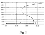
- the road shown in Fig. 1 begins at the bottom left and runs over points A, B. to point C.
- Fig. 2 are equidistant for the road shown in Fig. 1 by linear interpolation Path points calculated and shown as black points.
- FIG. 3 shows a section of FIG. 2, the railway line of the street in the area of path point B and the dashed guide line in the same Area. From path point B and five in front and one behind The points of focus were won in each case, the used ones Path points were considered to be points of equal mass.
- the double arrow points to path point B and the associated guideline point.
- FIG. 4 shows the image field with the axes XB, YB, the image field vertical YB in the direction of the tangent of the guide line at the respective guide point lies.
- the point of origin of the image field is located as a position point in the leadership point.
- the invention advantageously fulfills the requirements for calculating the mean Direction in the following way:
- the guideline intersects the curves and angles of the road more or more less and less curvature.
- the image field contains a representation of the course of the road in the middle local Direction, and the display is without jumps.
- the orientation of the display adapts continuously while driving, because A corresponding guide point is available for each location of the vehicle.
- the smoothing is as shown Distance range adjustable.
Landscapes
- Engineering & Computer Science (AREA)
- Radar, Positioning & Navigation (AREA)
- Remote Sensing (AREA)
- Automation & Control Theory (AREA)
- Physics & Mathematics (AREA)
- General Physics & Mathematics (AREA)
- Navigation (AREA)
- Processing Or Creating Images (AREA)
- Train Traffic Observation, Control, And Security (AREA)
Abstract
Bei einem Verfahren zur grafischen Darstellung einer vorausliegenden Straße in
ihrer mittleren örtlichen Richtung wird aus der Linie des Straßenverlaufs eine geglättete
Linie berechnet, wobei jedem Punkt der Bahnlinie ein Punkt der Führungslinie
zugeordnet ist und wobei die Führungslinienrichtung im jeweiligen Punkt der Führungslinie
als mittlere örtliche Richtung des Straßenverlaufs zur Orientierung des
Bildfelds und der Punkt auf der Führungslinie als Positionspunkt des Bildfeldes verwendet
wird.
Description
Die Erfindung betrifft ein Verfahren zur grafischen Darstellung einer vorausliegenden Straße in der mittleren örtlichen Straßenrichtung, insbesondere in einem Nahbereich.The invention relates to a method for the graphic representation of a preceding one Road in the middle of the local road direction, especially in a close-up area.
Häufig ist eine direkte Sicht des Fahrers auf den vorausliegenden Straßenverlauf behindert. Beispiele hierfür sind Fahrten bei Dunkelheit, Nebel oder Schneetreiben oder auf Strecken mit Gefälle, in Steilgelände eingebettete Kurven oder in der Kolonne hinter Großfahrzeugen.Often there is a direct view of the driver on the road ahead with special needs. Examples of this are trips in the dark, fog or blowing snow or on slopes with gradients, curves embedded in steep terrain or in a column behind large vehicles.
In diesen Situationen bestehen hohe Anforderungen an die Aufmerksamkeit des Fahrers und die Durchführung von Handlungen, einerseits zur Stabilisierung, andererseits zur Verfolgung der optimalen Trajektorie und der Durchführung von Manövern. Fehlende Sicht in Verbindung mit fehlender Ortskenntnis führt hier zu einer erheblichen Steigerung der Fahrerbelastung, zu erhöhtem Risiko und zu Unsicherheit in der Fahrzeugführung.In these situations there are high demands on the attention of the Driver and performing actions, on the one hand, for stabilization, on the other for tracking the optimal trajectory and performing maneuvers. A lack of visibility combined with a lack of local knowledge leads to one here considerable increase in driver stress, increased risk and uncertainty in the vehicle guidance.
Zur Vermeidung der vorgenannten Probleme sind Verfahren zur Straßenvisualisierung auf einem im Instrumentenbrett des Fahrzeugs angeordneten Fahrerbildschirm an sich bekannt.To avoid the aforementioned problems, there are road visualization procedures on a driver screen arranged in the instrument panel of the vehicle known per se.
Bei einer Vorrichtung gemäß der DE 19738764 A wird ein vorausliegender zu durchfahrender Straßenverlauf aus einer Straßendatenbasis und aus Navigationsdaten berechnet und fortlaufend in einem Bildfeld auf dem Fahrerbildschirm mit verschiedenen für die Fahrzeugführung wichtigen Objekten, wie beispielsweise Ansätzen der Nebenstraßen bei Kreuzungen, Hindernissen auf der Fahrbahn und virtuellen Leitplanken, jedoch ohne eine umfangreiche kartografische Umgebung dargestellt. In the case of a device according to DE 19738764 A, a vehicle ahead is to be driven through Road course from a road database and from navigation data calculated and continuously in an image field on the driver screen with different objects important for vehicle control, such as approaches of the Secondary roads at intersections, obstacles on the road and virtual guardrails, but presented without an extensive cartographic environment.
Der Fahrer kann diese Information mit kurzer Blickzuwendung zum Fahrerbildschirm erfassen und wird in Fahrsituatiuonen, in denen er einerseits seine Aufmerksamkeit in hohem Maße der realen Fahrszene widmen muß und wobei er andererseits auf eine derartige Information angewiesen ist, nicht abgelenkt.The driver can see this information with a quick glance at the driver's screen capture and will be in driving situations in which on the one hand his attention to a large extent dedicated to the real driving scene and on the other hand he such information is instructed, not distracted.
Die Straßendarstellung ist in verschiedenen Ausführungsvarianten möglich.The street display is possible in different versions.
In einer ersten Ausführungsvariante wird der Straßenverlauf perspektivisch dargestellt (auch Aerial View, Bird View genannt). Für diese Darstellung wird aus ergonomischen Gründen eine annähernde Übereinstimmung mit der tatsächlichen Ansicht des Fahrraumes hergestellt. Demzufolge ist eine Darstellung vom momentanen Ort des Fahrzeugs aus in Fahrtrichtung unumgänglich, und der Nachteil einer eingeschränkten Übersicht bei vorausliegender starker Richtungsänderung muß in Kauf genommen werden. Dieser Nachteil wird durch Vorteile der perspektivischen Darstellung, wie Vermittlung des Raumgefühls, plausible Staffelung einer weit vorausreichenden Darstellung, und Hervorhebung von Kurven durch Stauchung der Darstellung aufgewogen. Der Ort und die Fahrtrichtung sind aus Navigationsdaten bekannt, so daß die perspektivische Darstellung mit einem computergraphischen Transformationssystem direkt aus der digitalen Karte gewonnen wird.In a first embodiment, the course of the road is shown in perspective (also called Aerial View, Bird View). For this illustration, ergonomic For the sake of an approximation of the actual view of the driving area. Accordingly, it is a representation of the current location of the vehicle inevitable in the direction of travel, and the disadvantage of a limited Overview with a strong change of direction ahead must be purchased be taken. This disadvantage is due to the advantages of the perspective representation, like conveying the feeling of space, plausible staggering of a far-reaching one Representation and highlighting of curves by compressing the representation weighed. The location and the direction of travel are known from navigation data, so the perspective view with a computer graphic Transformation system is obtained directly from the digital map.
In einer zweiten Ausführungsvariante erfolgt die Darstellung wie aus senkrechter Sicht von oben (auch Map View genannt), vergleichbar mit einer Wegverlaufs-Skizze. Dabei ist die Darstellung ebenfalls in Fahrtrichtung orientiert. Diese Darstellungsweise erschwert, wie bereits beschrieben, vor einer Kurve oder Abbiegung die Übersicht über den vorausliegenden Straßenverlauf.In a second embodiment variant, the representation is as from vertical View from above (also called map view), comparable to a route sketch. The display is also oriented in the direction of travel. This way of presenting difficult, as already described, before a curve or turn Overview of the road ahead.
In der oben genannten Offenlegungsschrift wird vorgeschlagen, die Orientierung der Bildfeld-Vertikalen in der mittleren Richtung des zu durchfahrenden Straßenverlaufs zu wählen. Ein Verfahren zur Berechnung dieser mittleren Richtung wird jedoch nicht angegeben. In the above-mentioned laid-open publication it is suggested the orientation of the Field verticals in the middle direction of the road to be traveled to choose. A method for calculating this mean direction is however not specified.
Der Erfindung liegt die Aufgabe zugrunde, ein Verfahren der eingangs genannten Art zu schaffen, mit dem auf einfache Weise die mittleren Richtung des zu durchfahrenden Straßenverlaufs bestimmt werden kann, wobei folgende Anforderungen erfüllt werden müssen:The invention has for its object a method of the aforementioned To create a way with which the middle direction of the vehicle to be driven through The course of the road can be determined, the following requirements being met Need to become:
Die mittlere Richtung muß dem Fahrergefühl entsprechen und insoweit plausibel sein. Es ist die Richtung, in die ein Fahrer einen Kartenausschnitt drehen würde, wenn er einen Abschnitt seiner Fahrtroute in Vorausrichtung (Heading Up) überblicken will.The middle direction must correspond to the driver's feeling and is plausible his. It's the direction a driver would turn a map section if he has a section of his route in the head-up direction want.
Die Abfolge der mittleren Richtungen darf keine Sprünge enthalten, so daß sich insgesamt eine ruhige Abfolge der Darstellungs-Orientierung ergibt.The sequence of the middle directions must not contain jumps, so that there is a total results in a quiet sequence of the display orientation.
Die mittlere Richtung muß fortlaufend für jeden neuen Fahrzeugort zur Verfügung stehen, so daß die Orientierung der Darstellung während der Fahrt kontinuierlich erfolgt.The middle direction must be continuously available for each new vehicle location stand so that the orientation of the representation while driving continuously he follows.
Die mittlere Richtung muß dem im Bildfeld dargestellten Entfernungsbereich angepaßt sein, so daß sich bei kurvigem Straßenverlauf möglicherweise unterschiedliche mittlere Richtungen für einen gewählten kleinen oder einen gewählten großen Entfernungsbereich ergeben.The middle direction must be adapted to the distance range shown in the image field be so that when the road is winding, there may be differences medium directions for a chosen small or a chosen large distance range surrender.
Die Erfindung löst diese Aufgabe mit den Merkmalen des Patentanspruchs 1.The invention solves this problem with the features of claim 1.
Wenn sich das Fahrzeug auf einem bestimmten Bahnpunkt befindet, so wird als Bildorientierung, d. h. als Richtung der Bild-Vertikale die Richtung der Führungslinie im zugeordneten Führungslinienpunkt verwendet.If the vehicle is on a certain track point, then as Image orientation, d. H. the direction of the guideline as the direction of the image vertical used in the assigned leader point.
Der Bildfeld-Mittelpunkt oder ein anderer zweckmäßiger Bezugspunkt des Bildfeldes, beispielsweise ein Punkt der Bildfeld-Vertikale unterhalb des Bildfeld-Mittelpunktes, liegt im zugeordneten Führungslinienpunkt und bestimmt die Bildposition. The center of the image field or another suitable reference point of the image field, for example a point of the image field vertical below the image field center, lies in the assigned guideline point and determines the image position.
Die Bildposition und die Bildrichtung werden auf diese Weise anhand der Führungslinie ständig entsprechend der Fahrt des Fahrzeugs mitgeführt.The image position and the image direction are in this way based on the guide line constantly carried along according to the vehicle's travel.
Die Führungslinie besitzt auch die Voraussetzungen zur sequenzierten Darstellung, die bereits in der genannten Offenlegungsschrift beschrieben ist. Zu diesem Zweck wird das Bild an einem Führungslinienpunkt festgehalten, bis das Fahrzeug einen bestimmten vorausliegenden Bahnpunkt erreicht hat. Sodann wird das Bild mit erhöhter Geschwindigkeit auf der Führungslinie bis zu dem vorausliegenden Führungslinienpunkt nachgeführt, der dem vorausliegenden, vom Fahrzeug erreichten Bahnpunkt entspricht.The leader line also has the prerequisites for sequenced presentation, which has already been described in the aforementioned publication. To do this, the image is held at a leader point until the The vehicle has reached a certain point ahead. Then will the image at increased speed on the guideline up to the one ahead Guideline point tracked that of the vehicle ahead reached path point corresponds.
In einer vorteilhaften Ausführung der Erfindung wird ein zweistufiges Verfahren zur Entwicklung der Führungslinie angewandt.In an advantageous embodiment of the invention, a two-stage process for Leadership development applied.
Dabei werden in der ersten Stufe zwischen den in der Straßen-Datenbasis niedergelegten Punkten des zu durchfahrenden Straßenverlaufs äquidistante Punkte durch Interpolation vorzugsweise geradlinig aufgereiht. Diese äquidistanten Punkte werden als Bahnpunkte verwendet.In the first stage, between those stored in the street database Points of the road to be traveled through equidistant points Interpolation preferably lined up in a straight line. These are equidistant points used as path points.
Dabei ist eine ggf. auftretende geringfügige lokale Abweichung von der äquidistanten Teilung für das Verfahren ohne Bedeutung.There is a slight local deviation from the equidistant that may occur Division of no importance for the procedure.
Der Abstand dieser Bahnpunkte ist vorteilhafterweise so klein bemessen, daß eine Bewegung des Fahrzeugs von Bahnpunkt zu Bahnpunkt eine annähernd kontinuierliche Bewegung darstellt.The distance between these path points is advantageously dimensioned so small that a Movement of the vehicle from track point to track point an almost continuous Represents movement.
In der zweiten Stufe wird eine Glättungsoperation auf die Bahnpunkte angewandt. Die Glättungsoperation erstreckt sich jeweils über einen aktuellen und die in einem bestimmten Bereich voraus- und rückliegenden Bahnpunkte. Aus diesen Bahnpunkten wird ein Punkt einer geglätteten Linie, das ist der aktuelle Führungslinienpunkt, berechnet. In the second stage, a smoothing operation is applied to the path points. The smoothing operation extends over one current and one in one certain area ahead and past path points. From these train points becomes a point on a smoothed line, which is the current leader point, calculated.
Der aktuelle Bahnpunkt und der zugeordnete aktuelle Führungslinienpunkt besitzen eine feste gegenseitige Zuordnung.Have the current path point and the assigned current leader point a fixed mutual association.
Die Glättungsoperation besteht vorzugsweise in der Berechnung des Schwerpunkts aus dem aktuellen Bahnpunkt und den in einem bestimmten Bereich voraus- und rückliegenden Bahnpunkten, wobei diese Bahnpunkte gleiche Gewichte besitzen, und wobei dieser Schwerpunkt als ein dem aktuellen Bahnpunkt zugeordneter Punkt der Führungslinie verwendet wird.The smoothing operation is preferably the calculation of the center of gravity from the current path point and ahead and in a certain area previous path points, these path points having the same weights, and this center of gravity as a point associated with the current path point the guideline is used.
In einer weiteren erfindungsgemäßen Ausführung besitzen die in die Schwerpunktberechnung einbezogenen Bahnpunkte unterschiedliche Gewichte.In a further embodiment according to the invention, they have the center of gravity calculation included path points different weights.
Eine weitere erfindungsgemäße Ausführung verwendet eine Sehne zur Glättung des
Straßenverlaufs. Zu diesem Zweck wird zwischen zwei Stützstellen, nämlich von
einem zum aktuellen Bahnpunkt rückliegenden Punkt zu einem vorausliegenden
Bahnpunkt eine Sehne aufgespannt.
Die Bildrichtung stimmt bei dieser Ausführung mit der Richtung dieser Sehne überein.Another embodiment of the invention uses a chord to smooth the course of the road. For this purpose, a chord is stretched between two support points, namely from a point back to the current path point to a path point ahead.
The direction of the image in this version corresponds to the direction of this chord.
Der Bildfeld-Mittelpunkt oder ein anderer zweckmäßiger Bezugspunkt des Bildfeldes, beispielsweise ein Punkt der Bildfeld-Vertikale unterhalb des Bildfeld-Mittelpunktes, liegt auf der Sehnenmitte oder auf einem Punkt im unteren Bereich der Sehne.The center of the image field or another suitable reference point of the image field, for example a point of the image field vertical below the image field center, lies on the middle of the tendon or on a point in the lower area the tendon.
Die Sehne kann auch in der Weise aufgespannt werden, daß zunächst an den beiden Stützstellen zwei kurze Sehnen aufgespannt werden, und die richtungs- und positionsbestimmende Sehne sodann zwischen den Mittelpunkten der beiden kurzen Sehnen aufgespannt wird. The tendon can also be stretched in such a way that initially on the two Support points two short tendons, and the directional and position-determining tendon then between the centers of the two short tendons.
In einer weiteren erfindungsgemäßen Ausführung werden an sich bekannte interpolative Splines (beispielsweise Bezier Curves, B-Splines) zur Entwicklung einer glatten Führungslinie angewandt.In a further embodiment according to the invention, known interpolative Splines (e.g. Bezier Curves, B-Splines) to develop a smooth one Guideline applied.
Anhand eines in den Zeichnungen dargestellten Ausführungsbeispiels ist die Erfindung näher erläutert.The invention is based on an embodiment shown in the drawings explained in more detail.
Es zeigt
Die in Fig. 1 dargestellte Straße beginnt links unten und läuft über die Punkte A, B zum Punkt C.The road shown in Fig. 1 begins at the bottom left and runs over points A, B. to point C.
Am Punkt B befindet sich eine Abbiegestelle um 90 Grad nach links, gefolgt von einer Links- und einer Rechtskurve. Die in unterschiedlicher Distanz liegenden Datenbasispunkte sind im Straßenverlauf als schwarze Punkte dargestellt.At point B there is a turning point 90 degrees to the left, followed by a left and a right curve. The data base points located at different distances are shown as black dots along the road.
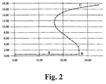
In Fig. 2 sind für die in Fig. 1 dargestellte Straße durch lineare Interpolation äquidistante Bahnpunkte berechnet und als schwarze Punkte dargestellt.In Fig. 2 are equidistant for the road shown in Fig. 1 by linear interpolation Path points calculated and shown as black points.
Die Fig. 3 zeigt in einem Ausschnitt von Fig.2 die Bahnlinie der Straße in der Umgebung des Bahnpunktes B und die gestrichelt eingezeichnete Führungslinie im gleichen Bereich. Aus dem Bahnpunkt B und jeweils fünf voraus- und rückliegenden Bahnpunkten wurde jeweils der Schwerpunkt gewonnen, wobei die verwendeten Bahnpunkte als massegleiche Punkte betrachtet wurden.3 shows a section of FIG. 2, the railway line of the street in the area of path point B and the dashed guide line in the same Area. From path point B and five in front and one behind The points of focus were won in each case, the used ones Path points were considered to be points of equal mass.
Der Doppelpfeil zeigt auf den Bahnpunkt B und den zugehörenden Führungslinienpunkt.The double arrow points to path point B and the associated guideline point.
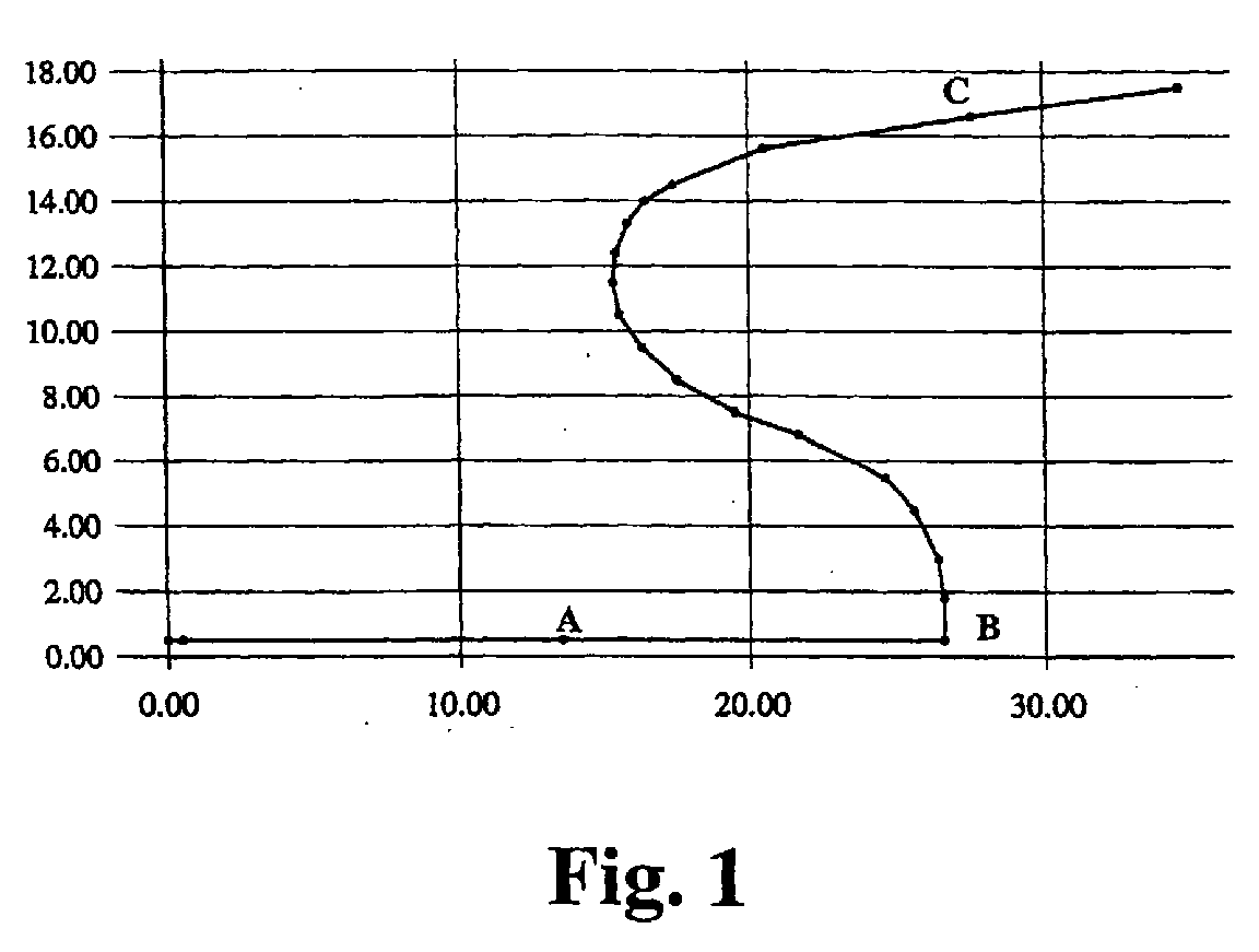
In Fig.4 ist das Bildfeld mit den Achsen XB, YB eingezeichnet, wobei die Bildfeld-Vertikale YB in der Richtung der Tangente der Führungslinie im jeweiligen Führungspunkt liegt. Der Ursprungspunkt des Bildfeldes befindet sich dabei als Positionspunkt im Führungspunkt.4 shows the image field with the axes XB, YB, the image field vertical YB in the direction of the tangent of the guide line at the respective guide point lies. The point of origin of the image field is located as a position point in the leadership point.
Die Erfindung erfüllt vorteilhaft die Anforderungen an eine Berechnung der mittleren Richtung in folgender Weise:The invention advantageously fulfills the requirements for calculating the mean Direction in the following way:
Die Führungslinie schneidet die Kurven und Winkel des Straßenverlaufs mehr oder weniger ab und besitzt in sich eine verminderte Kurvigkeit.The guideline intersects the curves and angles of the road more or more less and less curvature.
Das Bildfeld enthält eine Darstellung des Straßenverlaufs in der mittleren örtlichen Richtung, und die Darstellung erfolgt ohne Sprünge.The image field contains a representation of the course of the road in the middle local Direction, and the display is without jumps.
Die Orientierung der Darstellung paßt sich während der Fahrt kontinuierlich an, denn für jeden Ort des Fahrzeugs ist ein entsprechender Führungspunkt vorhanden.The orientation of the display adapts continuously while driving, because A corresponding guide point is available for each location of the vehicle.
Durch Auswahl der Länge des voraus- und rückliegenden Bereichs der Bahnlinie, auf den die Glättungsoperation angewandt wird, ist die Glättung dem dargestellten Entfernungsbereich anpaßbar.By selecting the length of the front and back area of the railway line, to which the smoothing operation is applied, the smoothing is as shown Distance range adjustable.
Aus dem Original-Straßenverlauf, wie er in der Straßen-Datenbasis gespeichert ist, wird für jeden während der Fahrt eingenommenen Ort des Fahrzeugs die mittlere Richtung des örtlichen Straßenverlaufs so berechnet, daß die beschriebenen Anforderungen an die Darstellung der mittleren Richtung in einem Bildfeld erfüllt werden.From the original course of the street, as it is stored in the street database, is the mean for each location of the vehicle occupied during the journey Direction of the local course of the road calculated so that the requirements described to represent the middle direction in an image field.
Claims (5)
Applications Claiming Priority (2)
| Application Number | Priority Date | Filing Date | Title |
|---|---|---|---|
| DE1999133503 DE19933503A1 (en) | 1999-07-16 | 1999-07-16 | Method for the graphical representation of a road ahead |
| DE19933503 | 1999-07-16 |
Publications (3)
| Publication Number | Publication Date |
|---|---|
| EP1069403A2 true EP1069403A2 (en) | 2001-01-17 |
| EP1069403A3 EP1069403A3 (en) | 2003-10-22 |
| EP1069403B1 EP1069403B1 (en) | 2015-05-13 |
Family
ID=7915089
Family Applications (1)
| Application Number | Title | Priority Date | Filing Date |
|---|---|---|---|
| EP20000115354 Expired - Lifetime EP1069403B1 (en) | 1999-07-16 | 2000-07-14 | Method for displaying the image of a route ahead |
Country Status (2)
| Country | Link |
|---|---|
| EP (1) | EP1069403B1 (en) |
| DE (1) | DE19933503A1 (en) |
Family Cites Families (4)
| Publication number | Priority date | Publication date | Assignee | Title |
|---|---|---|---|---|
| JPH07257228A (en) * | 1994-03-18 | 1995-10-09 | Nissan Motor Co Ltd | Vehicle display |
| JPH08254436A (en) * | 1995-01-20 | 1996-10-01 | Mitsubishi Electric Corp | Navigation device |
| US5874905A (en) * | 1995-08-25 | 1999-02-23 | Aisin Aw Co., Ltd. | Navigation system for vehicles |
| DE19738764A1 (en) * | 1997-09-04 | 1999-03-11 | Bayerische Motoren Werke Ag | Graphical display in motor vehicle for road map |
-
1999
- 1999-07-16 DE DE1999133503 patent/DE19933503A1/en not_active Ceased
-
2000
- 2000-07-14 EP EP20000115354 patent/EP1069403B1/en not_active Expired - Lifetime
Also Published As
| Publication number | Publication date |
|---|---|
| DE19933503A1 (en) | 2001-01-25 |
| EP1069403B1 (en) | 2015-05-13 |
| EP1069403A3 (en) | 2003-10-22 |
Similar Documents
| Publication | Publication Date | Title |
|---|---|---|
| DE102013105046B9 (en) | Target track selection method by means of navigation input in road change scenarios | |
| DE102005031409B4 (en) | Vehicle navigation system and computer program product | |
| EP2641057B1 (en) | Procedure for displaying navigation instructions | |
| EP0942403B1 (en) | Method and device for representation of information for a navigational apparatus | |
| DE10146744A1 (en) | Method and system for providing lane recommendations | |
| DE102006015719A1 (en) | Navigation system, for motor vehicle, has overlaid map sections showing actual position and adjacent map sections all overlaid with arrow shaped to follow turns from straight line to be seen without changing line of sight | |
| DE4035979A1 (en) | NAVIGATION SYSTEM FOR MOTOR VEHICLES | |
| DE4405771C2 (en) | Navigation system with a route determination method for quickly and precisely determining a desired route | |
| DE102008003395A1 (en) | Method for operating a navigation system | |
| EP1886093B1 (en) | Method for determining the geometry of a route section | |
| EP1957940B1 (en) | Navigation method for at least one means of transportation | |
| EP3649434B1 (en) | Method and device for displaying lane information in a vehicle | |
| DE102010029822A1 (en) | Motor vehicle with a navigation system | |
| EP1873493B1 (en) | Method for automatic, computer-supported determination of a navigable route for vehicles | |
| DE102004063034A1 (en) | navigation device | |
| DE102014209751A1 (en) | Display of maneuver instructions for a route | |
| DE102011083370A1 (en) | Method for determining route to be preferred from set of routes between start and target points using navigation system in motor car, involves reading value of emotion parameter that represents emotion of user, within range of value | |
| DE102009046855A1 (en) | Additional data providing method for digital road map that guides driver of passenger car, involves storing data vector of driving parameters and position and data of ending section of intersection point in map to provide additional data | |
| DE102022130172A1 (en) | Method and driver assistance system to support a driver when driving in a proximity area of a trajectory | |
| WO2023138822A1 (en) | Device and method for determining a reference profile | |
| EP2028445A2 (en) | Method of and device for determining a route in a road network | |
| DE102017222563A1 (en) | Method and device for communication between several motor vehicles | |
| EP1069403B1 (en) | Method for displaying the image of a route ahead | |
| EP1069406B1 (en) | Method for the graphical representation of a street ahead | |
| EP1255092B1 (en) | Device and method for displaying information in a vehicle |
Legal Events
| Date | Code | Title | Description |
|---|---|---|---|
| PUAI | Public reference made under article 153(3) epc to a published international application that has entered the european phase |
Free format text: ORIGINAL CODE: 0009012 |
|
| AK | Designated contracting states |
Kind code of ref document: A2 Designated state(s): AT BE CH CY DE DK ES FI FR GB GR IE IT LI LU MC NL PT SE |
|
| AX | Request for extension of the european patent |
Free format text: AL;LT;LV;MK;RO;SI |
|
| PUAL | Search report despatched |
Free format text: ORIGINAL CODE: 0009013 |
|
| AK | Designated contracting states |
Kind code of ref document: A3 Designated state(s): AT BE CH CY DE DK ES FI FR GB GR IE IT LI LU MC NL PT SE |
|
| AX | Request for extension of the european patent |
Extension state: AL LT LV MK RO SI |
|
| RIC1 | Information provided on ipc code assigned before grant |
Ipc: 7G 01C 7/04 A Ipc: 7G 01C 21/34 B |
|
| 17P | Request for examination filed |
Effective date: 20031113 |
|
| AKX | Designation fees paid |
Designated state(s): DE FR GB IT |
|
| 17Q | First examination report despatched |
Effective date: 20071213 |
|
| RAP1 | Party data changed (applicant data changed or rights of an application transferred) |
Owner name: BAYERISCHE MOTOREN WERKE AKTIENGESELLSCHAFT |
|
| REG | Reference to a national code |
Ref country code: DE Ref legal event code: R079 Ref document number: 50016405 Country of ref document: DE Free format text: PREVIOUS MAIN CLASS: G01C0007040000 Ipc: G01C0021360000 |
|
| GRAP | Despatch of communication of intention to grant a patent |
Free format text: ORIGINAL CODE: EPIDOSNIGR1 |
|
| RIC1 | Information provided on ipc code assigned before grant |
Ipc: G01C 21/36 20060101AFI20141125BHEP |
|
| INTG | Intention to grant announced |
Effective date: 20141223 |
|
| GRAS | Grant fee paid |
Free format text: ORIGINAL CODE: EPIDOSNIGR3 |
|
| GRAA | (expected) grant |
Free format text: ORIGINAL CODE: 0009210 |
|
| AK | Designated contracting states |
Kind code of ref document: B1 Designated state(s): DE FR GB IT |
|
| REG | Reference to a national code |
Ref country code: GB Ref legal event code: FG4D Free format text: NOT ENGLISH |
|
| REG | Reference to a national code |
Ref country code: DE Ref legal event code: R096 Ref document number: 50016405 Country of ref document: DE Effective date: 20150625 |
|
| REG | Reference to a national code |
Ref country code: DE Ref legal event code: R097 Ref document number: 50016405 Country of ref document: DE |
|
| PLBE | No opposition filed within time limit |
Free format text: ORIGINAL CODE: 0009261 |
|
| STAA | Information on the status of an ep patent application or granted ep patent |
Free format text: STATUS: NO OPPOSITION FILED WITHIN TIME LIMIT |
|
| 26N | No opposition filed |
Effective date: 20160216 |
|
| PG25 | Lapsed in a contracting state [announced via postgrant information from national office to epo] |
Ref country code: IT Free format text: LAPSE BECAUSE OF FAILURE TO SUBMIT A TRANSLATION OF THE DESCRIPTION OR TO PAY THE FEE WITHIN THE PRESCRIBED TIME-LIMIT Effective date: 20150513 |
|
| REG | Reference to a national code |
Ref country code: FR Ref legal event code: PLFP Year of fee payment: 17 |
|
| PGFP | Annual fee paid to national office [announced via postgrant information from national office to epo] |
Ref country code: GB Payment date: 20160722 Year of fee payment: 17 Ref country code: DE Payment date: 20160726 Year of fee payment: 17 |
|
| PGFP | Annual fee paid to national office [announced via postgrant information from national office to epo] |
Ref country code: FR Payment date: 20160722 Year of fee payment: 17 |
|
| REG | Reference to a national code |
Ref country code: DE Ref legal event code: R119 Ref document number: 50016405 Country of ref document: DE |
|
| GBPC | Gb: european patent ceased through non-payment of renewal fee |
Effective date: 20170714 |
|
| REG | Reference to a national code |
Ref country code: FR Ref legal event code: ST Effective date: 20180330 |
|
| PG25 | Lapsed in a contracting state [announced via postgrant information from national office to epo] |
Ref country code: DE Free format text: LAPSE BECAUSE OF NON-PAYMENT OF DUE FEES Effective date: 20180201 Ref country code: GB Free format text: LAPSE BECAUSE OF NON-PAYMENT OF DUE FEES Effective date: 20170714 |
|
| PG25 | Lapsed in a contracting state [announced via postgrant information from national office to epo] |
Ref country code: FR Free format text: LAPSE BECAUSE OF NON-PAYMENT OF DUE FEES Effective date: 20170731 |