EP1063493A2 - Navigation system and storage medium - Google Patents
Navigation system and storage medium Download PDFInfo
- Publication number
- EP1063493A2 EP1063493A2 EP00111101A EP00111101A EP1063493A2 EP 1063493 A2 EP1063493 A2 EP 1063493A2 EP 00111101 A EP00111101 A EP 00111101A EP 00111101 A EP00111101 A EP 00111101A EP 1063493 A2 EP1063493 A2 EP 1063493A2
- Authority
- EP
- European Patent Office
- Prior art keywords
- image data
- branch
- point
- present
- data
- Prior art date
- Legal status (The legal status is an assumption and is not a legal conclusion. Google has not performed a legal analysis and makes no representation as to the accuracy of the status listed.)
- Granted
Links
Images





Classifications
-
- G—PHYSICS
- G01—MEASURING; TESTING
- G01C—MEASURING DISTANCES, LEVELS OR BEARINGS; SURVEYING; NAVIGATION; GYROSCOPIC INSTRUMENTS; PHOTOGRAMMETRY OR VIDEOGRAMMETRY
- G01C21/00—Navigation; Navigational instruments not provided for in groups G01C1/00 - G01C19/00
- G01C21/26—Navigation; Navigational instruments not provided for in groups G01C1/00 - G01C19/00 specially adapted for navigation in a road network
- G01C21/34—Route searching; Route guidance
- G01C21/36—Input/output arrangements for on-board computers
- G01C21/3626—Details of the output of route guidance instructions
- G01C21/3658—Lane guidance
-
- G—PHYSICS
- G01—MEASURING; TESTING
- G01C—MEASURING DISTANCES, LEVELS OR BEARINGS; SURVEYING; NAVIGATION; GYROSCOPIC INSTRUMENTS; PHOTOGRAMMETRY OR VIDEOGRAMMETRY
- G01C21/00—Navigation; Navigational instruments not provided for in groups G01C1/00 - G01C19/00
- G01C21/26—Navigation; Navigational instruments not provided for in groups G01C1/00 - G01C19/00 specially adapted for navigation in a road network
- G01C21/34—Route searching; Route guidance
- G01C21/36—Input/output arrangements for on-board computers
- G01C21/3626—Details of the output of route guidance instructions
- G01C21/3647—Guidance involving output of stored or live camera images or video streams
Definitions
- the present invention relates to a navigation system arranged to display an enlarged view of a branch-point image by using image data when the vehicle is within a predetermined distance from a branch point such as an intersection on a suggested route.
- the present invention also relates to a storage medium having a program for executing the above-described display processing.
- a typical navigation system for vehicles searches, upon entry of a destination and a transit point, for a route to the destination and guides the vehicle to the destination.
- a navigation system arranged such that when the vehicle is within a predetermined distance from an intersection on a suggested route at which the driver should turn, the navigation system displays an enlarged view of the intersection prepared from road node data or displays image data concerning the intersection that has been stored in advance.
- Fig. 9 shows an enlarged view of an intersection [part (a) of Fig. 9] and an enlarged view of a branch point [part (b) of Fig. 9], which are displayed by such a conventional navigation system.
- an ordinary map prepared from road node data is displayed on the left-hand part of a two-part split screen, and an enlarged view of a branch point drawn by using image data is displayed on the right-hand part of the two-part split screen.
- a mark A indicating the present position of the vehicle is shown on the map prepared from the node data on the left-hand part.
- On the right-hand part displaying the image data only a direction in which the vehicle should advance is shown, but the present position of the vehicle is not displayed.
- An enlarged view of an intersection prepared from road node data has coordinates as position information concerning nodes. Therefore, a mark indicating the present position of the vehicle can be displayed so as to move according to the distance between the vehicle and the intersection.
- a present-position mark cannot be displayed nor moved according to the distance between the vehicle and the intersection. Therefore, with an enlarged view of an intersection displayed by using image data, the user cannot ascertain the present position of the vehicle at the intersection and may mistakenly turn at an intersection adjacent to the suggested intersection or pass the intersection at which he or she should turn.
- an object of the present invention is to provide a navigation system of the type wherein an enlarged view of a branch point such as an intersection is displayed by using image data, which is designed so that a present-position mark can be displayed superimposed on the image data and the present-position mark thus displayed can be moved according to the distance between the present position and the branch point.
- the present invention provides a navigation system including a present-position detecting unit for detecting the present position of a vehicle and an input unit for entering a destination and information necessary for a route search.
- An information storage unit stores data necessary for a route search.
- the data includes branch-point image data having coordinates added thereto according to the distance from a branch point, such as an intersection, and road data.
- a display unit displays route guidance information.
- a route search unit searches for a route to the destination on the basis of the information entered by the input unit and the data stored in the information storage unit.
- a control unit reads the branch-point image data when the vehicle is within a predetermined distance from a branch point on a route found by the route search unit and outputs the branch-point image data to the display unit so that a present-position mark is superimposed on the branch-point image data on the basis of the coordinates of the present position detected by the present-position detecting unit and the coordinates added to the branch-point image data.
- the present-position mark may be displayed so as to move according to the distance from the vehicle to the branch point.
- the image data has a flag indicating whether or not the image data has coordinates added thereto according to the distance from a branch point such as an intersection.
- the image data includes data concerning the size thereof when it is expanded, and has a coordinate offset from a specific coordinate point to a display reference point.
- the present invention provides a storage medium having a program including the step of detecting a present position and the step of storing data necessary for route guidance.
- the data includes branch-point image data having coordinates added thereto according to the distance from a branch point such as an intersection.
- the program further includes the step of searching for a route and displaying route guidance information, and the step of comparing the coordinates of the detected present position with the coordinates added to the branch-point image data when the present position is within a predetermined distance from a branch point on a route found by the searching step, and displaying a present-position mark superimposed on the branch-point image data.
- the present invention provides a storage medium containing branch-point image data having coordinates added thereto according to the distance from a branch point such as an intersection and further having data concerning the size of the image data when it is expanded and a coordinate offset from a specific coordinate point to a display reference point.
- Fig. 1 is a block diagram showing a structural example of the navigation system according to the present invention.
- the navigation system includes the following units.
- An input unit 1 is used to enter information relating to route guidance.
- a present-position detecting unit 2 detects information relating to the present position of a vehicle equipped with this navigation system.
- An information storage unit 3 contains the record of navigation data necessary for route calculation, display/voice guidance data necessary for route guidance, programs (applications and/or an OS), and so forth.
- a central processing unit 4 executes route finding processing, display/voice guidance processing necessary for route guidance, and control of the overall system.
- An information transmit/receive unit 5 transmits and receives information relating to driving of vehicles, e.g. road information and traffic information, and detects information relating to the present position of the vehicle and further transmits and receives information relating to the present position.
- An output unit 6 outputs information relating to route guidance.
- the input unit 1 has the functions of entering a destination and allowing the driver to instruct the central processing unit 4 to execute navigation processing at his/her own will.
- a touch switch and a remote controller e.g. a jog dial
- the input unit 1 further has a device for performing interaction by voice input.
- the input unit 1 also functions as a voice input unit. It is possible to add a record card reader for reading data recorded on an IC card or a magnetic card.
- a data communication device for exchanging data between information sources such as an information center in which data necessary for navigation has been stored and which provides information through a communication channel upon request from the driver, and a portable electronic unit having data, e.g. map data, destination data, simplified map data, and structure-shape map data.
- the information storage unit 3 is an external storage unit in which programs and data for navigation have been stored, for example, a CD-ROM.
- the information storage unit 3 stores programs for executing processing such as route finding processing, programs for executing processing shown in the flowchart stated in this embodiment, programs for executing display-output control necessary for route guidance and for executing interactive guidance by voice input, together with data necessary therefor, and programs for executing voice output control necessary for voice guidance, together with data necessary therefor.
- the information storage unit 3 stores all data necessary for the navigation system.
- the data comprises files such as map data, search data, guidance data, map matching data, destination data, registered-location data, road data, image data concerning branch points, e.g. intersections, data classified by genre, and landmark data. It should be noted that the present invention is also applicable to a type in which only data is stored in a CD-ROM and programs are stored in a central processing unit.
- the central processing unit 4 includes a CPU for executing various kinds of arithmetic processing; a flash memory for storing a program read out of the CD-ROM of the information storage unit 3; a ROM containing a program for executing program check for the flash memory and a program for executing update processing (i.e. program read means); and a RAM for temporarily storing the location coordinates of a set destination, guidance information for a found route, such as the code number of a road, and data which is in the course of being processed.
- the central processing unit 4 further has the following devices: a speech processor which executes interactive processing by voice input from the input unit 1 and which, on the basis of a voice-output control signal from the CPU, combines voice, phrases, single sentences and sounds read out of the information storage unit 3, converts the result to an analog signal and delivers it to a speaker; a communication interface for performing an exchange of input/output data by communication; a sensor-input interface for inputting sensor signals from the present-position detecting unit 2; and a clock for entering date and time into internal dialog information.
- a speech processor which executes interactive processing by voice input from the input unit 1 and which, on the basis of a voice-output control signal from the CPU, combines voice, phrases, single sentences and sounds read out of the information storage unit 3, converts the result to an analog signal and delivers it to a speaker
- a communication interface for performing an exchange of input/output data by communication
- a sensor-input interface for inputting sensor signals from the present-position detecting unit 2
- a clock for entering date
- the programs related to the present invention and the other programs for carrying out navigation may be all stored in a CD-ROM as an external storage medium.
- some or all of the programs may be stored in the ROM provided in the central processing unit 4 of the navigation system.
- the data and programs stored in the external storage medium are input as external signals to the central processing unit 4 of the navigation system and subjected to arithmetic processing, thereby allowing various navigation functions to be implemented.
- the navigation system contains a flash memory of relatively large capacity for reading in a program from a CD-ROM as an external storage device, and a ROM of small capacity for storing a program (program read means) for CD boot-up processing.
- the flash memory is a non-volatile storage device, in which stored information is retained even when the power supply is cut off.
- program in the ROM which is a program read means, is started to check the program stored in the flash memory, and disk management information in the CD-ROM as the information storage unit 3 is read in.
- Program loading processing (update processing) is executed by judging the disk management information and the state of the flash memory.
- the information transmit/receive unit 5 comprises a GPS receiver for obtaining information by utilizing a global positioning system (GPS), a VICS information receiver for obtaining information by using FM multiplex data broadcasting, a radio beacon, a light beacon, etc., a data transceiver for bidirectionally communicating information with an information center (e.g. ATIS) or other vehicles by using, for example, a cellular phone or a personal computer, etc.
- GPS global positioning system
- VICS information receiver for obtaining information by using FM multiplex data broadcasting
- radio beacon e.g. a radio beacon, a light beacon, etc.
- a data transceiver for bidirectionally communicating information with an information center (e.g. ATIS) or other vehicles by using, for example, a cellular phone or a personal computer, etc.
- ATIS information center
- the output unit 6 has the functions of outputting guidance information by voice and/or a screen display when required by the driver and printing out data for navigation processed in the central processing unit 4. As devices for implementing these functions, the output unit 6 has a display for displaying route guidance on a screen, a printer for printing out data processed by the central processing unit 4 and data stored in the information storage unit 3, and a speaker for outputting route guidance by voice.
- the display is a simple liquid-crystal display device or the like.
- the display device displays a screen of an enlarged view of an intersection, the name of a destination, time, distance, arrows indicating a heading direction, etc.
- image data sent to the display is binary image data (bit map data)
- it is not always necessary to use a special-purpose image signal line but possible to use a communication line used for serial communications or to share the use of other communication lines.
- the display has a memory for temporarily holding bit map data.
- the display is provided inside the instrument panel in the vicinity of the driver's seat. Viewing the display enables the driver to ascertain the present location of the vehicle and to obtain information regarding a route from this location.
- the arrangement may be such that a data tablet including a touch panel, a touch screen, etc. is used for the display screen to allow a location, a road, etc. to be entered by touching the screen or tracing over it.
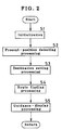
- Fig. 2 is a flowchart for describing the flow of processing in the overall navigation system according to the present invention.
- step S1 When the route guidance program is read into the central processing unit 4 from the information storage unit 3 and started (step S1), the present position is detected by the present-position detecting unit 2, and a map of surroundings centered on the present position is displayed, and further the name of the present position and so forth are displayed (step S2).
- step S3 the destination is set (step S3) by using the name of a target object, e.g. a place name or a facility name, a telephone number, an address, a registered location, a road name, etc.
- a route search is executed to find a route from the present position to the destination (step S4).
- route guidance and display are performed repeatedly (step S5) until the destination is reached while the present position is followed up by the present-position detecting unit 2. If there is entry of en-route setting before the destination is reached, a search area is set, and re-search is executed in the set search area. In this way, route guidance is similarly performed repeatedly until the destination is reached.
- Fig. 3 is a diagram illustrating the structure of image data used in the present invention.
- Image data used to display an enlarged view of a branch point such as an intersection comprises a header section, an image data section, and a route data section.
- the header section contains image data classification, i.e. GIF, TIFF, and JPEG, palette set ID defining a color palette set to be used when the image data is expanded (in image drawing), sizes in X- and Y-directions when the stored image data is expanded, and X- and Y-coordinate offsets from the bottom left coordinate point of the expanded image data to a reference coordinate point (display reference point).
- the image data classification also contains an image data compression method and a flag indicating whether or not there is route data.
- the route data section contains position coordinate data concerning some points on a route in the form of coordinates with respect to the bottom left coordinate point of the image data.
- the route data section will be described below by way of an example shown in Figs. 4 and 5.
- the size of image data is 100 dots by 100 dots (the size in the X-direction after expansion is 100 dots and the size in the Y-direction after expansion is 100 dots)
- an enlarged view drawn by using the image data is displayed in the image display area, and position coordinates of 4 points are added to the route with respect to the bottom left coordinate point (0, 0).
- coordinate data items (50, 0), (50, 25), (50, 40) and (50, 50) are stored in the route data section.
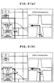
- a present-position mark is displayed on an enlarged view of an image displayed by image data by using the coordinates added to the image data.
- a present-position mark A is displayed, together with a suggested route, on a map prepared from node data.
- an enlarged view of an intersection at which the driver should turn is displayed by using image data.
- the present position on the image data is located, and a present-position mark B is displayed superimposed on the image data, together with an arrow indicating a direction in which the driver should turn.
- the present-position mark B displayed on the image data moves in synchronism with the present-position mark A.
- Fig. 7 shows an example in which an enlarged view of a branch point is displayed as image data.
- the present position on the image data is located by a comparison between the position coordinate data in the route data section and the present-position data, and a present-position mark B is displayed superimposed on the image data.
- the present-position mark B displayed on the image data moves as the vehicle travels.
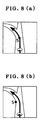
- Fig. 8 shows an example of the X-coordinate offset from the bottom left coordinate point of image data to a reference coordinate point (display reference point).
- a reference coordinate point display reference point
- coordinates are added to image data according to the distance from a branch point such as an intersection, and a present-position mark is displayed superimposed on the image data on the basis of the coordinates added to the image data and the coordinates of the detected present position.
- the present-position mark displayed on the image data can be moved according to the distance from the branch point. Accordingly, it becomes possible to guide the vehicle reliably at an intersection or a branch point on a suggested route where the driver should turn.
- Branch-point image data has coordinates added thereto according to the distance from a branch point such as an intersection.
- the coordinates of the present position of the vehicle and the coordinates added to the branch-point image data are compared to locate the present position on the image data, and a present-position mark is displayed superimposed on the branch-point image data.
- the displayed present-position mark moves according to the distance between the vehicle and the branch point.
Landscapes
- Engineering & Computer Science (AREA)
- Radar, Positioning & Navigation (AREA)
- Remote Sensing (AREA)
- Automation & Control Theory (AREA)
- Physics & Mathematics (AREA)
- General Physics & Mathematics (AREA)
- Multimedia (AREA)
- Navigation (AREA)
- Traffic Control Systems (AREA)
Abstract
Description
Claims (7)
- A navigation system comprising:present-position detecting means for detecting a present position of a vehicle;input means for entering a destination and information necessary for a route search;information storage means for storing data necessary for a route search, said data including branch-point image data having coordinates added thereto according to a distance from a branch point, such as an intersection, and road data;display means for displaying route guidance information;route search means for searching for a route to the destination on a basis of the information entered by said input means and the data stored in said information storage means; andcontrol means for reading said branch-point image data when the vehicle is within a predetermined distance from a branch point on a route found by said route search means and for outputting said branch-point image data to said display means so that a present-position mark is superimposed on said branch-point image data on a basis of coordinates of the present position detected by said present-position detecting means and the coordinates added to said branch-point image data.
- A navigation system according to claim 1, wherein the present-position mark is displayed so as to move according to a distance from the vehicle to the branch point.
- A navigation system according to claim 1, wherein said image data has a flag indicating whether or not said image data has coordinates added thereto according to a distance from a branch point such as an intersection.
- A navigation system according to claim 1, wherein said image data includes data concerning a size thereof when it is expanded, and has a coordinate offset from a specific coordinate point to a display reference point.
- A storage medium having a program comprising the steps of:detecting a present position;storing data necessary for route guidance, said data including branch-point image data having coordinates added thereto according to a distance from a branch point such as an intersection;searching for a route and displaying route guidance information; andcomparing coordinates of the detected present position with the coordinates added to said branch-point image data when the present position is within a predetermined distance from a branch point on a route found by said searching step, and displaying a present-position mark superimposed on said branch-point image data.
- A storage medium containing branch-point image data having coordinates added thereto according to a distance from a branch point such as an intersection.
- A storage medium according to claim 6, wherein said image data includes data concerning a size thereof when it is expanded, and has a coordinate offset from a specific coordinate point to a display reference point.
Applications Claiming Priority (2)
| Application Number | Priority Date | Filing Date | Title |
|---|---|---|---|
| JP14365699A JP3475123B2 (en) | 1999-05-24 | 1999-05-24 | Navigation device and storage medium |
| JP14365699 | 1999-05-24 |
Publications (3)
| Publication Number | Publication Date |
|---|---|
| EP1063493A2 true EP1063493A2 (en) | 2000-12-27 |
| EP1063493A3 EP1063493A3 (en) | 2002-12-04 |
| EP1063493B1 EP1063493B1 (en) | 2017-07-19 |
Family
ID=15343877
Family Applications (1)
| Application Number | Title | Priority Date | Filing Date |
|---|---|---|---|
| EP00111101.2A Expired - Lifetime EP1063493B1 (en) | 1999-05-24 | 2000-05-23 | Navigation system and storage medium |
Country Status (4)
| Country | Link |
|---|---|
| US (1) | US6694255B1 (en) |
| EP (1) | EP1063493B1 (en) |
| JP (1) | JP3475123B2 (en) |
| CN (1) | CN1304120A (en) |
Cited By (3)
| Publication number | Priority date | Publication date | Assignee | Title |
|---|---|---|---|---|
| EP1445583A1 (en) * | 2003-02-10 | 2004-08-11 | Lg Electronics Inc. | Navigation system with progression indication |
| US6950743B2 (en) * | 2002-03-25 | 2005-09-27 | Aisin Aw Co., Ltd. | Navigation system and program for navigation system setup |
| EP1677078A3 (en) * | 2004-12-28 | 2009-08-19 | Nissan Motor Company, Limited | System and method for navigation |
Families Citing this family (28)
| Publication number | Priority date | Publication date | Assignee | Title |
|---|---|---|---|---|
| JP3532492B2 (en) * | 1999-06-25 | 2004-05-31 | 株式会社ザナヴィ・インフォマティクス | Road traffic information providing system, information providing device, and navigation device |
| AU2001277234A1 (en) * | 2000-07-31 | 2002-02-13 | Regents Of The University Of Minnesota | Open TEM resonators for MRI |
| JP4882151B2 (en) * | 2000-12-27 | 2012-02-22 | ソニー株式会社 | Information processing apparatus, information processing method, recording medium, and image processing apparatus |
| JP3722010B2 (en) * | 2001-05-14 | 2005-11-30 | 株式会社デンソー | Navigation device |
| US7673246B2 (en) * | 2001-12-12 | 2010-03-02 | Canon Kabushiki Kaisha | Image information processing apparatus and method, virtual space presentation apparatus, information administration apparatus, and control methods thereof |
| US7411594B2 (en) * | 2002-01-15 | 2008-08-12 | Canon Kabushiki Kaisha | Information processing apparatus and method |
| JP4170178B2 (en) * | 2003-09-04 | 2008-10-22 | 三菱電機株式会社 | Route search device |
| US7366607B2 (en) * | 2003-11-28 | 2008-04-29 | Fujitsu Ten Limited | Navigation apparatus |
| US20080201070A1 (en) * | 2004-06-18 | 2008-08-21 | Navitime Japan Co., Ltd. | Communicative Navigation System, Information Distribution Server, and Mobile Navigation Terminal |
| JP4466238B2 (en) * | 2004-07-07 | 2010-05-26 | 株式会社デンソー | Vehicle navigation device |
| JP4513740B2 (en) * | 2005-12-28 | 2010-07-28 | アイシン・エィ・ダブリュ株式会社 | Route guidance system and route guidance method |
| JP4795206B2 (en) * | 2006-03-10 | 2011-10-19 | 三菱電機株式会社 | Navigation device |
| US20070233371A1 (en) * | 2006-03-31 | 2007-10-04 | Arne Stoschek | Navigation system for a motor vehicle |
| JP2008013111A (en) * | 2006-07-07 | 2008-01-24 | Denso Corp | Vehicle equipment automatic operation device |
| JP4556925B2 (en) * | 2006-07-31 | 2010-10-06 | 株式会社デンソー | Branch guidance device and guide map generation device |
| KR100836677B1 (en) | 2006-09-19 | 2008-06-10 | 주식회사 레인콤 | Automotive Navigation System with Auxiliary Display |
| CN101197094B (en) * | 2006-12-08 | 2010-06-16 | 高德软件有限公司 | Guiding method for continuous branching in electronic map |
| JP4352182B2 (en) * | 2007-02-19 | 2009-10-28 | 株式会社カシオ日立モバイルコミュニケーションズ | Portable terminal device and program |
| KR100837345B1 (en) * | 2007-06-25 | 2008-06-12 | (주)엠앤소프트 | Method of Displaying the Magnification of Intersection in Vehicle Terminal |
| JP4450028B2 (en) * | 2007-07-23 | 2010-04-14 | 株式会社デンソー | Route guidance device |
| CN101409009B (en) * | 2008-11-05 | 2010-10-13 | 青岛海信电子产业控股股份有限公司 | Method and system for road surface calibration |
| JP2011095238A (en) * | 2009-09-30 | 2011-05-12 | Aisin Aw Co Ltd | Navigation device and program |
| JP2011214936A (en) * | 2010-03-31 | 2011-10-27 | Denso Corp | Road information display device |
| JP5510054B2 (en) * | 2010-05-14 | 2014-06-04 | 株式会社デンソー | Navigation device |
| WO2012090325A1 (en) * | 2010-12-28 | 2012-07-05 | トヨタ自動車株式会社 | Navigation apparatus |
| JP6446784B2 (en) * | 2014-01-21 | 2019-01-09 | 株式会社デンソー | Navigation device |
| KR101750876B1 (en) * | 2015-05-28 | 2017-06-26 | 엘지전자 주식회사 | Display apparatus for vehicle and Vehicle |
| JP6542708B2 (en) * | 2016-04-22 | 2019-07-10 | 株式会社Subaru | Display device |
Citations (3)
| Publication number | Priority date | Publication date | Assignee | Title |
|---|---|---|---|---|
| EP0767448A1 (en) | 1995-10-04 | 1997-04-09 | Aisin Aw Co., Ltd. | Navigation apparatus for a vehicle |
| EP0777206A1 (en) | 1995-11-30 | 1997-06-04 | Aisin Aw Co., Ltd. | Vehicular navigation apparatus |
| EP0836167A1 (en) | 1996-08-21 | 1998-04-15 | Aisin Aw Co., Ltd. | Device for displaying map and method |
Family Cites Families (12)
| Publication number | Priority date | Publication date | Assignee | Title |
|---|---|---|---|---|
| DE702209C (en) | 1936-04-18 | 1941-02-01 | I G Farbenindustrie Akt Ges | Process for improving the processability and solubility of rubber-like polymers of butadiene |
| DE767448C (en) | 1941-08-09 | 1952-11-04 | Deutsche Edelstahlwerke Ag | Device for progressive partial surface hardness of metallic workpieces by means of inductive heating |
| DK75534C (en) | 1949-04-15 | 1953-03-02 | Akerlund & Rausing Ab | Egg packaging with transverse partitions. |
| CA1295737C (en) * | 1986-03-14 | 1992-02-11 | Akira Ichikawa | Apparatus for displaying travel path |
| JP3511561B2 (en) * | 1996-09-11 | 2004-03-29 | パイオニア株式会社 | Map information display device, navigation device, and recording medium recording navigation program |
| DE4327780C2 (en) * | 1992-08-19 | 1998-12-17 | Aisin Aw Co | Vehicle navigation system and vehicle navigation method |
| EP0660289B1 (en) * | 1993-12-27 | 2001-10-04 | Aisin Aw Co., Ltd. | Map display system |
| US5757289A (en) * | 1994-09-14 | 1998-05-26 | Aisin Aw Co., Ltd. | Vehicular navigation system |
| DE69635426T2 (en) * | 1995-06-13 | 2006-08-03 | Matsushita Electric Industrial Co., Ltd., Kadoma | Vehicle navigation device and recording medium for program storage therefor |
| US5874905A (en) * | 1995-08-25 | 1999-02-23 | Aisin Aw Co., Ltd. | Navigation system for vehicles |
| DE69625142T2 (en) * | 1995-09-08 | 2003-04-24 | Aisin Aw Co., Ltd. | Car navigation system |
| KR960042490A (en) * | 1995-11-09 | 1996-12-21 | 모리 하루오 | Vehicle navigation device and recording medium therefor |
-
1999
- 1999-05-24 JP JP14365699A patent/JP3475123B2/en not_active Expired - Lifetime
-
2000
- 2000-05-23 EP EP00111101.2A patent/EP1063493B1/en not_active Expired - Lifetime
- 2000-05-23 US US09/576,216 patent/US6694255B1/en not_active Expired - Lifetime
- 2000-05-24 CN CN00119225.6A patent/CN1304120A/en active Pending
Patent Citations (3)
| Publication number | Priority date | Publication date | Assignee | Title |
|---|---|---|---|---|
| EP0767448A1 (en) | 1995-10-04 | 1997-04-09 | Aisin Aw Co., Ltd. | Navigation apparatus for a vehicle |
| EP0777206A1 (en) | 1995-11-30 | 1997-06-04 | Aisin Aw Co., Ltd. | Vehicular navigation apparatus |
| EP0836167A1 (en) | 1996-08-21 | 1998-04-15 | Aisin Aw Co., Ltd. | Device for displaying map and method |
Cited By (6)
| Publication number | Priority date | Publication date | Assignee | Title |
|---|---|---|---|---|
| US6950743B2 (en) * | 2002-03-25 | 2005-09-27 | Aisin Aw Co., Ltd. | Navigation system and program for navigation system setup |
| EP1445583A1 (en) * | 2003-02-10 | 2004-08-11 | Lg Electronics Inc. | Navigation system with progression indication |
| US7440850B2 (en) | 2003-02-10 | 2008-10-21 | Lg Electronics Inc. | Navigation system and the operating method thereof |
| US7698063B2 (en) | 2003-02-10 | 2010-04-13 | Lg Electronics, Inc. | Navigation system and the operating method thereof |
| EP1677078A3 (en) * | 2004-12-28 | 2009-08-19 | Nissan Motor Company, Limited | System and method for navigation |
| US7729854B2 (en) | 2004-12-28 | 2010-06-01 | Nissan Motor Co., Ltd. | System and method for navigation |
Also Published As
| Publication number | Publication date |
|---|---|
| JP2000337900A (en) | 2000-12-08 |
| CN1304120A (en) | 2001-07-18 |
| EP1063493B1 (en) | 2017-07-19 |
| EP1063493A3 (en) | 2002-12-04 |
| JP3475123B2 (en) | 2003-12-08 |
| US6694255B1 (en) | 2004-02-17 |
Similar Documents
| Publication | Publication Date | Title |
|---|---|---|
| US6694255B1 (en) | Navigation system and storage medium | |
| KR100269069B1 (en) | Car navigation system and storage media | |
| US6243646B1 (en) | Vehicle navigation system with pixel transmission to display | |
| JP3171145B2 (en) | Information display device provided with touch panel and storage medium | |
| KR100260760B1 (en) | Information display device with a touch panel | |
| JP3719315B2 (en) | Vehicle navigation device and storage medium | |
| JPH1151674A (en) | Car navigation system and recording medium | |
| JP3748042B2 (en) | Navigation device | |
| US6560530B1 (en) | Navigation system | |
| JPH10332404A (en) | Navigation device | |
| KR100270235B1 (en) | Car navigation system | |
| JP2003057059A (en) | Navigation apparatus and program | |
| JP2000337899A (en) | Navigation device and storage medium | |
| JP3760958B2 (en) | Navigation device | |
| JP3546719B2 (en) | Vehicle navigation device and storage medium | |
| JP2000046566A (en) | Map display device and storage medium | |
| JP3865038B2 (en) | Navigation device and storage medium | |
| JP3389148B2 (en) | Navigation device and storage medium | |
| KR100521056B1 (en) | Method for displaying information in car navigation system | |
| JP3801358B2 (en) | Vehicle navigation apparatus and method | |
| JP3262036B2 (en) | Vehicle navigation device and storage medium | |
| JPH0868657A (en) | Guiding device | |
| JP2001141504A (en) | Information display | |
| JPH10153448A (en) | Navigation device for vehicle and storage medium | |
| JP2004286761A (en) | Navigation system for vehicles |
Legal Events
| Date | Code | Title | Description |
|---|---|---|---|
| PUAI | Public reference made under article 153(3) epc to a published international application that has entered the european phase |
Free format text: ORIGINAL CODE: 0009012 |
|
| AK | Designated contracting states |
Kind code of ref document: A2 Designated state(s): AT BE CH CY DE DK ES FI FR GB GR IE IT LI LU MC NL PT SE |
|
| AX | Request for extension of the european patent |
Free format text: AL;LT;LV;MK;RO;SI |
|
| 17P | Request for examination filed |
Effective date: 20001114 |
|
| PUAL | Search report despatched |
Free format text: ORIGINAL CODE: 0009013 |
|
| RIC1 | Information provided on ipc code assigned before grant |
Free format text: 7G 01C 21/36 A, 7G 01C 21/30 B, 7G 01C 21/26 B, 7G 01C 21/34 B, 7G 08G 1/0969 B |
|
| AK | Designated contracting states |
Kind code of ref document: A3 Designated state(s): AT BE CH CY DE DK ES FI FR GB GR IE IT LI LU MC NL PT SE |
|
| AX | Request for extension of the european patent |
Free format text: AL;LT;LV;MK;RO;SI |
|
| AKX | Designation fees paid |
Designated state(s): DE FR GB |
|
| 17Q | First examination report despatched |
Effective date: 20070810 |
|
| RAP1 | Party data changed (applicant data changed or rights of an application transferred) |
Owner name: FUJITSU TEN LIMITED Owner name: DENSO CORPORATION Owner name: AISIN AW CO., LTD. Owner name: TOYOTA JIDOSHA KABUSHIKI KAISHA Owner name: PANASONIC CORPORATION |
|
| RAP1 | Party data changed (applicant data changed or rights of an application transferred) |
Owner name: TOYOTA JIDOSHA KABUSHIKI KAISHA Owner name: DENSO CORPORATION Owner name: AISIN AW CO., LTD. Owner name: PANASONIC CORPORATION Owner name: FUJITSU TEN LIMITED |
|
| GRAJ | Information related to disapproval of communication of intention to grant by the applicant or resumption of examination proceedings by the epo deleted |
Free format text: ORIGINAL CODE: EPIDOSDIGR1 |
|
| STAA | Information on the status of an ep patent application or granted ep patent |
Free format text: STATUS: GRANT OF PATENT IS INTENDED |
|
| GRAP | Despatch of communication of intention to grant a patent |
Free format text: ORIGINAL CODE: EPIDOSNIGR1 |
|
| INTG | Intention to grant announced |
Effective date: 20170124 |
|
| RIN1 | Information on inventor provided before grant (corrected) |
Inventor name: FUJIMOTO, HIDETOSHI, C/O DENSO CORPORATION Inventor name: KAINUMA, MAMORU, C/O AISIN AW CO., LTD. Inventor name: TOOYAMA, YASUHIRO, C/O AISIN AW CO., LTD. Inventor name: KIMURA, MASAHIRO, C/O DENSO CORPORATION Inventor name: ICHIMURA, ATSUSHI, C/O FUJITSU TEN LIMITED Inventor name: TAKEUCHI, HIROSHI, C/O FUJITSU TEN LIMITED Inventor name: OGAWA, ISAO, MATSUSHITA ELECTRIC IND. CO., LTD. Inventor name: SUGIMOTO, HIRONOBU, C/O TOYOTA JIDOSHA KABUSHIKI K Inventor name: SUZUKI, HIDENOBU, C/O TOYOTA JIDOSHA KABUSHIKI KAI |
|
| GRAS | Grant fee paid |
Free format text: ORIGINAL CODE: EPIDOSNIGR3 |
|
| GRAA | (expected) grant |
Free format text: ORIGINAL CODE: 0009210 |
|
| STAA | Information on the status of an ep patent application or granted ep patent |
Free format text: STATUS: THE PATENT HAS BEEN GRANTED |
|
| AK | Designated contracting states |
Kind code of ref document: B1 Designated state(s): DE FR GB |
|
| REG | Reference to a national code |
Ref country code: GB Ref legal event code: FG4D |
|
| REG | Reference to a national code |
Ref country code: DE Ref legal event code: R096 Ref document number: 60049667 Country of ref document: DE |
|
| REG | Reference to a national code |
Ref country code: FR Ref legal event code: PLFP Year of fee payment: 19 |
|
| REG | Reference to a national code |
Ref country code: DE Ref legal event code: R097 Ref document number: 60049667 Country of ref document: DE |
|
| PLBE | No opposition filed within time limit |
Free format text: ORIGINAL CODE: 0009261 |
|
| STAA | Information on the status of an ep patent application or granted ep patent |
Free format text: STATUS: NO OPPOSITION FILED WITHIN TIME LIMIT |
|
| 26N | No opposition filed |
Effective date: 20180420 |
|
| PGFP | Annual fee paid to national office [announced via postgrant information from national office to epo] |
Ref country code: DE Payment date: 20190508 Year of fee payment: 20 |
|
| PGFP | Annual fee paid to national office [announced via postgrant information from national office to epo] |
Ref country code: FR Payment date: 20190410 Year of fee payment: 20 |
|
| PGFP | Annual fee paid to national office [announced via postgrant information from national office to epo] |
Ref country code: GB Payment date: 20190522 Year of fee payment: 20 |
|
| REG | Reference to a national code |
Ref country code: DE Ref legal event code: R071 Ref document number: 60049667 Country of ref document: DE |
|
| REG | Reference to a national code |
Ref country code: GB Ref legal event code: PE20 Expiry date: 20200522 |
|
| PG25 | Lapsed in a contracting state [announced via postgrant information from national office to epo] |
Ref country code: GB Free format text: LAPSE BECAUSE OF EXPIRATION OF PROTECTION Effective date: 20200522 |