EP0973011B1 - Method and apparatus for providing route guidance in a vehicle navigation system - Google Patents
Method and apparatus for providing route guidance in a vehicle navigation system Download PDFInfo
- Publication number
- EP0973011B1 EP0973011B1 EP99305598A EP99305598A EP0973011B1 EP 0973011 B1 EP0973011 B1 EP 0973011B1 EP 99305598 A EP99305598 A EP 99305598A EP 99305598 A EP99305598 A EP 99305598A EP 0973011 B1 EP0973011 B1 EP 0973011B1
- Authority
- EP
- European Patent Office
- Prior art keywords
- manoeuvre
- user
- instruction
- distance
- vehicle
- Prior art date
- Legal status (The legal status is an assumption and is not a legal conclusion. Google has not performed a legal analysis and makes no representation as to the accuracy of the status listed.)
- Expired - Lifetime
Links
Images


Classifications
-
- G—PHYSICS
- G01—MEASURING; TESTING
- G01C—MEASURING DISTANCES, LEVELS OR BEARINGS; SURVEYING; NAVIGATION; GYROSCOPIC INSTRUMENTS; PHOTOGRAMMETRY OR VIDEOGRAMMETRY
- G01C21/00—Navigation; Navigational instruments not provided for in groups G01C1/00 - G01C19/00
- G01C21/26—Navigation; Navigational instruments not provided for in groups G01C1/00 - G01C19/00 specially adapted for navigation in a road network
- G01C21/34—Route searching; Route guidance
- G01C21/36—Input/output arrangements for on-board computers
- G01C21/3626—Details of the output of route guidance instructions
- G01C21/3629—Guidance using speech or audio output, e.g. text-to-speech
-
- G—PHYSICS
- G01—MEASURING; TESTING
- G01C—MEASURING DISTANCES, LEVELS OR BEARINGS; SURVEYING; NAVIGATION; GYROSCOPIC INSTRUMENTS; PHOTOGRAMMETRY OR VIDEOGRAMMETRY
- G01C21/00—Navigation; Navigational instruments not provided for in groups G01C1/00 - G01C19/00
- G01C21/26—Navigation; Navigational instruments not provided for in groups G01C1/00 - G01C19/00 specially adapted for navigation in a road network
- G01C21/34—Route searching; Route guidance
- G01C21/36—Input/output arrangements for on-board computers
- G01C21/3626—Details of the output of route guidance instructions
- G01C21/3632—Guidance using simplified or iconic instructions, e.g. using arrows
Definitions
- the present invention relates to route guidance in the context of a vehicle navigation system. More specifically, methods and apparatus are described, by way of example in illustration of the invention, in which audible route guidance instructions are provided to the user of a vehicle navigation system.
- JP 05 332778 discloses a system arranged to adjust the volume of a speaker of a navigation device in order to compensate for variations in vehicle engine noise, air conditioning noise, radio noise, and noise produced by an open vehicle window.
- US-A-5177685 discloses an automobile navigation system arranged to provide spoken instructions to the driver of an automobile to guide the driver along a route.
- the system comprises a computing apparatus comprising a map database, route finding algorithms, a vehicle location system, discourse generating programs, and speech generating programs.
- a user interface allows the driver to enter information such as a desired destination, from which the route finding algorithms in the computer apparatus calculate a route to the destination.
- the vehicle location system accepts input from a position sensor which measures automobile movement (magnitude and direction) continuously, and using this data in conjunction with the map database, determines the position of the automobile.
- the discourse generating programs Based on the current position of the automobile and the route, the discourse generating programs compose driving instructions and other messages according to a discourse model in real time as they are needed. The instructions and messages are sent to voice generating apparatus which conveys them to the driver.
- US-A-5544060 discloses a navigation system for a vehicle which enables an operator to know a calculated optimal path from a starting point to a destination before departure. After the optimal path is calculated, a preview function allows the operator to sequentially view the calculated optimal path either prior to departure or at any point along the optimal path. A cancel function allows the operator to cancel a displayed portion of the optimal path and to request calculation and display of an alternate optimal path which does not employ the canceled portion of the original optimal path.
- voice guidance techniques to be described below by way of example in illustration of the invention are that they provide a greater level of detail with regard to upcoming manoeuvres than previously proposed arrangements without degrading overall system performance, and enable a user to use a system more effectively.
- the effect of only presenting manoeuvre instructions as the vehicle approaches an associated manoeuvre may not prove to be sufficient to provide a desirable level of comfort for some users, and the provision of means for minimising this problem as well as the problem caused by variations in background noise which affect a user's ability to hear instructions as they are given is desirable.
- the street name associated with each manoeuvre is included in the audio representation which is communicated to the user.
- the system determines the street name and then constructs an audio representation of the street name using voice synthesis techniques.
- the synthesized audio representation is then incorporated with generic prerecorded instruction components, e.g., "right turn ahead at”, to generate an appropriate manoeuvre instruction.
- This has the great advantage of identifying the upcoming manoeuvre with greater particularity, therefore further reducing the user's dependence on the visual display.
- this arrangement obviates the need to store an audio representation for every street name in the map database, a currently impracticable solution.
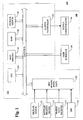
- Fig. 1 is a block schematic diagram of a specific vehicle navigation system 100 which is suitable for use in carrying out the present invention.
- Sensors 112 and 114, traffic data receiver 116, and GPS receiver 118 are coupled to computing means 120 through sensor/GPS interface 122.
- the mileage sensor 112 includes an odometer
- the angular velocity sensor 114 includes a gyroscope, or a differential odometer coupled to the wheels of a vehicle.
- the traffic data receiver 116 may include any of a wide variety of RF receivers which are operable to receive real time traffic data transmitted in a variety of formats.
- a global positioning system (GPS) data receiver 118 is provided for receiving signals from, for example, a satellite-based navigation system.
- GPS global positioning system
- Data from sensor/GPS interface 122 is transmitted to a CPU 124, which performs calibration, signal processing, dead-reckoning, vehicle positioning, and route calculation and guidance functions.
- a database containing map information may be stored in a database medium 126, with software directing the operation of computing means 120 stored in a main memory 128 for execution by the CPU 124.
- the memory 128 may include any of a wide variety of non-volatile memories, such as, for example, a read-only memory (ROM), a reprogrammable non-volatile memory such as flash memory, or an SRAM, a CD ROM, an optical disk, or PCMCIA cards.
- a system RAM 130 permits the reading and writing of the information necessary to execute such software programs.
- the database medium 126 may include a non-volatile memory, a hard disk drive, a CD-ROM, or an integrated circuit in which digitized map information has been stored.
- An output controller 132 which may include a graphics controller, receives data processed by the CPU 124 and transmits the data to a display console 140 which includes an output communicator 134, usually including a display screen with associated audio electronics and speakers.
- the user may input data, such as a desired destination, through a user interface 136, typically a keyboard.
- the user interface 136 may be a microphone coupled to speech recognition circuitry allowing a user to communicate with the system using voice commands.
- the map database stored in the database medium 126 preferably includes positional data such as, for example, latitude and longitude coordinates, to describe road intersections or nodes, road segments, landmarks and points of interest, and other geographical information.
- the database may further include data representing characteristics of roads or places on the map, such as road and place names, road features such as dividers, one-way restrictions, surface, speed limit, shape, elevation, and other properties.
- the map database includes cost values associated with individual nodes and road segments. These cost values correspond to the estimates of time intervals for traversing the respective node or segment. Node cost values take into consideration such information as, for example, whether the vehicle would encounter oncoming traffic, thus delaying a left turn manoeuvre.
- Segment costs reflect road segment characteristics such as speed limit and segment length, both of which affect the travel time along the segment.
- a hierarchy value which relates to the category or type of the road. For example, the highest level category of the hierarchy includes freeways and expressways. The lowest level includes residential streets and/or alleys.
- the information stored in the map database medium 126 is employed with the data received from the interface 122 for route calculation and guidance.
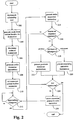
- Fig. 2 is a flowchart for use in illustrating the operation of an example in which a user of the system can request that the system should present a sequence of manoeuvre instructions at any point during navigation on a generated route.
- the sequence can be all previously presented instructions up to the current vehicle position, or all remaining instructions from the current vehicle position to the final manoeuvre.
- a route is generated from the current location of the vehicle to the destination 204 according to any of a wide variety of route generation techniques.
- the route is generated according to techniques described in commonly assigned, copending U.S. patent Application No.
- a manoeuvre instruction is generated for each of the manoeuvres 208 for communication to the user during navigation.
- the generated instructions include audio representations which are audibly presented over a system speaker.
- the audio representations are constructed from a library of generic phrases such as, for example, "right turn”, "one-half mile ahead", etc.
- a manoeuvre pointer, or some other suitable mechanism for keeping track of the upcoming manoeuvre is then set to the first manoeuvre 210. If the vehicle is approaching the upcoming manoeuvre 212, i.e., is within some threshold distance of the manoeuvre, the associated manoeuvre instruction is presented to the user 214. That is, in the particular arrangement described above, the audio representation of the manoeuvre instruction is presented over the system speaker. In various examples , the mileage to the upcoming manoeuvre is indicated in the instruction.
- the actuation of a soft key in the user interface 216 causes the system to present a sequence of instructions. If the user has indicated that the remaining manoeuvre instructions are desired 218, the system presents all remaining manoeuvre instructions from the upcoming manoeuvre (i.e., the current pointer location) to the final manoeuvre on the route 220. If, on the other hand, the user has indicated that previous instructions are desired 218, the system presents all previous instructions from the first manoeuvre to the most recently presented manoeuvre 222.
- the user may take advantage of this feature at any point after the manoeuvre instructions have been generated. That is, even before the vehicle embarks on the generated route, the user may request an audio presentation of the remaining manoeuvre instructions, i.e., the entire set of manoeuvre instructions. For example, in one specific illustrative example, once they have been generated, all of the manoeuvre instructions for the generated route are visually presented in a graphical user interface (GUI) on the system's display screen.
- GUI graphical user interface
- the GUI includes information for each manoeuvre such as, for example, a manoeuvre icon representing the manoeuvre, the road name at which the manoeuvre is to occur, and the distance from the previous manoeuvre.
- the user may request an audio presentation of the entire set of manoeuvre instructions by the actuation of a soft key or by the issuance of a verbal command.
- the manoeuvre pointer is advanced to the next manoeuvre 226 and the process repeats from 212. If the last manoeuvre has been presented the process ends.
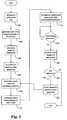
- Fig. 3 is a flowchart for use in describing an aspect of an embodiment of the present invention.
- the user can request that the system repeat the most recently presented manoeuvre instruction at any point during navigation.
- a route is generated from the current location of the vehicle to the destination 304, according to any of a wide variety of route generation techniques, as discussed above.
- the system determines a series of manoeuvres that the vehicle will need to execute to stay on the route 306.
- a manoeuvre instruction is generated for each of the manoeuvres 308 for communication to the user during navigation.
- a manoeuvre pointer or some other suitable mechanism for keeping track of the upcoming manoeuvre is then set to the first manoeuvre 310. If the vehicle is approaching the upcoming manoeuvre 312, i.e., is within some threshold distance of the manoeuvre, the associated manoeuvre instruction is presented to the user 314.
- the actuation of a soft key in the user interface 316 causes the system to repeat the most recently presented manoeuvre instruction 318.
- the mileage to the upcoming manoeuvre is adjusted to reflect any change in the vehicle's position.
- the repeated instruction indicates that the manoeuvre is to be executed in 0.3 miles.
- This arrangement employs 0.1 mile increments. Other arrangements may employ greater or lesser sensitivity or employ other terms of linear measurement. If the last manoeuvre instruction for the route has not been presented 320, the manoeuvre pointer is advanced to the next manoeuvre 322 and the process repeats from 312. If the last manoeuvre has been presented the process ends.
- Fig. 4 is a flowchart for use in describing yet another illustrative example.
- the audio level for manoeuvre instructions is adjusted in response to the vehicle speed and/or to the ambient noise level.
- a route is generated from the current location of the vehicle to the destination 404, according to any of a wide variety of route generation techniques as discussed above.
- the system determines a series of manoeuvres that the vehicle will need to execute to stay on the route 406.
- a manoeuvre instruction is generated for each of the manoeuvres 408 for communication to the user during navigation.
- a manoeuvre pointer, or some other suitable mechanism for keeping track of the upcoming manoeuvre, is then set to the first manoeuvre 410.
- the vehicle speed 414 and the ambient noise level 416 are determined and the audio level is set to an appropriate level for the background noise 418.
- the audio level either remains unchanged, is adjusted up, or is adjusted down based on the vehicle speed and/or the ambient noise level.
- the determination of the ambient noise may be accomplished using any of a variety of sound capture techniques and is well within the capabilities of one of skill in the art.
- the manoeuvre instruction associated with the upcoming manoeuvre is then presented 420. If the last manoeuvre instruction for the route has not been presented 422, the manoeuvre pointer is advanced to the next manoeuvre 424 and the process repeats from 412. If the last manoeuvre has been presented the process ends.
- Fig. 5 is a flowchart for use in describing an aspect of an embodiment of the present invention.
- enhanced audio manoeuvre instructions are generated and presented which include the name of the street at which the upcoming manoeuvre takes place.
- a route is generated from the current location of the vehicle to the destination 504 according to any of a wide variety of route generation techniques, as discussed above.
- the system determines a series of manoeuvres that the vehicle will need to execute to stay on the route 506.
- a manoeuvre pointer or some other suitable mechanism for keeping track of the upcoming manoeuvre is then set to the first manoeuvre 508.
- the street name for the upcoming manoeuvre is then determined using information about the route and the current vehicle position 510.
- An audio representation of the street name is then synthesized using any of a variety of speech synthesis techniques 512.
- the synthesized street name is then incorporated, with appropriate pre-recorded generic instruction elements from the system's library into a manoeuvre instruction 514.
- these generic instruction elements include mileage indicators, e.g., "0.5 miles ahead”.
- access to the features described herein may be implemented in a variety of ways. That is, the actuation of a soft key is merely one way in which a user may get the system to repeat a previous instruction or to present a series of manoeuvres. Other methods could include the use of voice recognition technology enabling the user to make verbal requests.
Description
- The present invention relates to route guidance in the context of a vehicle navigation system. More specifically, methods and apparatus are described, by way of example in illustration of the invention, in which audible route guidance instructions are provided to the user of a vehicle navigation system.
- The utility of providing voice guidance in vehicle navigation systems is unquestioned in the industry. This is particularly true where voice guidance reduces the necessity for the driver to make visual contact with the system's display in situations where it may be hazardous to do so, i.e., when the vehicle is in motion. In fact, as speech synthesis and voice recognition technologies mature it is likely that vehicle navigation systems will become increasingly dependent on such technologies for many system functions including, for example, destination selection, route guidance, and even vehicle security.
- Most currently available vehicle navigation systems provide some level of voice guidance to the user. For example, a driver might be alerted to an upcoming manoeuvre with a warning "Right turn ahead" or "Next exit on the left" when the vehicle is determined to be within some threshold distance to the manoeuvre. However, given the complexity and uniqueness of each vehicle's circumstances and the wide variety of road topologies, it is currently very difficult to provide voice instructions which describe an upcoming manoeuvre with even a moderate level of precision. That is, for example, systems do not typically identify the road at which the right turn is to be made or the name of the upcoming exit. This is largely due to the fact that vehicle navigation systems typically employ a library of voice instructions, the size of which is kept relatively small to conserve memory and processing resources. Obviously, recording and storing a number of manoeuvres for each street name in a typical map database is not practicable.
-
JP 05 332778 -
US-A-5177685 discloses an automobile navigation system arranged to provide spoken instructions to the driver of an automobile to guide the driver along a route. The system comprises a computing apparatus comprising a map database, route finding algorithms, a vehicle location system, discourse generating programs, and speech generating programs. A user interface allows the driver to enter information such as a desired destination, from which the route finding algorithms in the computer apparatus calculate a route to the destination. The vehicle location system accepts input from a position sensor which measures automobile movement (magnitude and direction) continuously, and using this data in conjunction with the map database, determines the position of the automobile. Based on the current position of the automobile and the route, the discourse generating programs compose driving instructions and other messages according to a discourse model in real time as they are needed. The instructions and messages are sent to voice generating apparatus which conveys them to the driver. -
US-A-5544060 discloses a navigation system for a vehicle which enables an operator to know a calculated optimal path from a starting point to a destination before departure. After the optimal path is calculated, a preview function allows the operator to sequentially view the calculated optimal path either prior to departure or at any point along the optimal path. A cancel function allows the operator to cancel a displayed portion of the optimal path and to request calculation and display of an alternate optimal path which does not employ the canceled portion of the original optimal path. - Features of voice guidance techniques to be described below by way of example in illustration of the invention are that they provide a greater level of detail with regard to upcoming manoeuvres than previously proposed arrangements without degrading overall system performance, and enable a user to use a system more effectively. For example, the effect of only presenting manoeuvre instructions as the vehicle approaches an associated manoeuvre may not prove to be sufficient to provide a desirable level of comfort for some users, and the provision of means for minimising this problem as well as the problem caused by variations in background noise which affect a user's ability to hear instructions as they are given is desirable.
- Methods and apparatus to be described below, by way of example in illustration of the invention enable voice guidance to be given to the driver of a vehicle using a navigation system in which the driver's dependency on the system's visual display is reduced.
- According to an aspect of the present invention, there is provided a method according to claim 19.
- According to another aspect of the present invention, there is provided a vehicle navigation system according to claim 1.
- The street name associated with each manoeuvre is included in the audio representation which is communicated to the user. For each instruction, the system determines the street name and then constructs an audio representation of the street name using voice synthesis techniques. The synthesized audio representation is then incorporated with generic prerecorded instruction components, e.g., "right turn ahead at", to generate an appropriate manoeuvre instruction. This has the great advantage of identifying the upcoming manoeuvre with greater particularity, therefore further reducing the user's dependence on the visual display. In addition, this arrangement obviates the need to store an audio representation for every street name in the map database, a currently impracticable solution.
- The following description and drawings disclose, by means of examples, the invention which is characterised in the appended claims, whose terms determine the extent of the protection conferred hereby.
- In the drawings:-
-
Fig. 1 is a block schematic diagram for use in describing a vehicle navigation system, -
Fig. 2 is a flowchart for use in describing the operation of a vehicle navigation system. -
Fig. 3 is a flowchart for use in describing an aspect of a method of operation of a vehicle navigation system in accordance within an embodiment of the present invention, -
Fig. 4 is a flowchart for use in describing a method of operation of a vehicle navigation system, -
Fig. 5 is a flowchart for use in describing an aspect of a method of operation of a vehicle navigation system in accordance with an embodiment of the present invention. -
Fig. 1 is a block schematic diagram of a specificvehicle navigation system 100 which is suitable for use in carrying out the present invention.Sensors traffic data receiver 116, andGPS receiver 118 are coupled to computing means 120 through sensor/GPS interface 122. In typical embodiments, themileage sensor 112 includes an odometer, and theangular velocity sensor 114 includes a gyroscope, or a differential odometer coupled to the wheels of a vehicle. Thetraffic data receiver 116 may include any of a wide variety of RF receivers which are operable to receive real time traffic data transmitted in a variety of formats. A global positioning system (GPS)data receiver 118 is provided for receiving signals from, for example, a satellite-based navigation system. Data from sensor/GPS interface 122 is transmitted to aCPU 124, which performs calibration, signal processing, dead-reckoning, vehicle positioning, and route calculation and guidance functions. A database containing map information may be stored in adatabase medium 126, with software directing the operation of computing means 120 stored in amain memory 128 for execution by theCPU 124. Various arrangements for use in illustrating the present invention are embodied as such software. Thememory 128 may include any of a wide variety of non-volatile memories, such as, for example, a read-only memory (ROM), a reprogrammable non-volatile memory such as flash memory, or an SRAM, a CD ROM, an optical disk, or PCMCIA cards. Asystem RAM 130 permits the reading and writing of the information necessary to execute such software programs. Thedatabase medium 126 may include a non-volatile memory, a hard disk drive, a CD-ROM, or an integrated circuit in which digitized map information has been stored. Anoutput controller 132, which may include a graphics controller, receives data processed by theCPU 124 and transmits the data to adisplay console 140 which includes anoutput communicator 134, usually including a display screen with associated audio electronics and speakers. The user may input data, such as a desired destination, through auser interface 136, typically a keyboard. Alternatively, theuser interface 136 may be a microphone coupled to speech recognition circuitry allowing a user to communicate with the system using voice commands. - The map database stored in the
database medium 126 preferably includes positional data such as, for example, latitude and longitude coordinates, to describe road intersections or nodes, road segments, landmarks and points of interest, and other geographical information. The database may further include data representing characteristics of roads or places on the map, such as road and place names, road features such as dividers, one-way restrictions, surface, speed limit, shape, elevation, and other properties. In specific arrangements to be described by way of example in illustration of the invention, the map database includes cost values associated with individual nodes and road segments. These cost values correspond to the estimates of time intervals for traversing the respective node or segment. Node cost values take into consideration such information as, for example, whether the vehicle would encounter oncoming traffic, thus delaying a left turn manoeuvre. Segment costs reflect road segment characteristics such as speed limit and segment length, both of which affect the travel time along the segment. Also associated with each road in the map database is a hierarchy value which relates to the category or type of the road. For example, the highest level category of the hierarchy includes freeways and expressways. The lowest level includes residential streets and/or alleys. The information stored in themap database medium 126 is employed with the data received from theinterface 122 for route calculation and guidance. -
Fig. 2 is a flowchart for use in illustrating the operation of an example in which a user of the system can request that the system should present a sequence of manoeuvre instructions at any point during navigation on a generated route. The sequence can be all previously presented instructions up to the current vehicle position, or all remaining instructions from the current vehicle position to the final manoeuvre. Upon the selection of a destination by theuser 202, a route is generated from the current location of the vehicle to thedestination 204 according to any of a wide variety of route generation techniques. In one particular example, the route is generated according to techniques described in commonly assigned, copendingU.S. patent Application No. 08/784,204 U.S. Patent No. 5,712,788 for INCREMENTAL ROUTE CALCULATION issued on January 27, 1998. - Once the route has been generated, the system determines a series of manoeuvres that the vehicle will need to execute to stay on the
route 206. A manoeuvre instruction is generated for each of themanoeuvres 208 for communication to the user during navigation. In one particular example, the generated instructions include audio representations which are audibly presented over a system speaker. The audio representations are constructed from a library of generic phrases such as, for example, "right turn", "one-half mile ahead", etc. A manoeuvre pointer, or some other suitable mechanism for keeping track of the upcoming manoeuvre, is then set to thefirst manoeuvre 210. If the vehicle is approaching theupcoming manoeuvre 212, i.e., is within some threshold distance of the manoeuvre, the associated manoeuvre instruction is presented to theuser 214. That is, in the particular arrangement described above, the audio representation of the manoeuvre instruction is presented over the system speaker. In various examples , the mileage to the upcoming manoeuvre is indicated in the instruction. - If at any time during navigation the user would like more than one of the instructions to be presented, the actuation of a soft key in the
user interface 216 causes the system to present a sequence of instructions. If the user has indicated that the remaining manoeuvre instructions are desired 218, the system presents all remaining manoeuvre instructions from the upcoming manoeuvre (i.e., the current pointer location) to the final manoeuvre on theroute 220. If, on the other hand, the user has indicated that previous instructions are desired 218, the system presents all previous instructions from the first manoeuvre to the most recently presentedmanoeuvre 222. - The user may take advantage of this feature at any point after the manoeuvre instructions have been generated. That is, even before the vehicle embarks on the generated route, the user may request an audio presentation of the remaining manoeuvre instructions, i.e., the entire set of manoeuvre instructions. For example, in one specific illustrative example, once they have been generated, all of the manoeuvre instructions for the generated route are visually presented in a graphical user interface (GUI) on the system's display screen. The GUI includes information for each manoeuvre such as, for example, a manoeuvre icon representing the manoeuvre, the road name at which the manoeuvre is to occur, and the distance from the previous manoeuvre. At this point, the user may request an audio presentation of the entire set of manoeuvre instructions by the actuation of a soft key or by the issuance of a verbal command.
- If the last manoeuvre instruction for the route has not been presented 224, the manoeuvre pointer is advanced to the
next manoeuvre 226 and the process repeats from 212. If the last manoeuvre has been presented the process ends. -
Fig. 3 is a flowchart for use in describing an aspect of an embodiment of the present invention. In this aspect the user can request that the system repeat the most recently presented manoeuvre instruction at any point during navigation. Upon the selection of a destination by theuser 302, a route is generated from the current location of the vehicle to thedestination 304, according to any of a wide variety of route generation techniques, as discussed above. Once the route has been generated, the system determines a series of manoeuvres that the vehicle will need to execute to stay on theroute 306. A manoeuvre instruction is generated for each of themanoeuvres 308 for communication to the user during navigation. A manoeuvre pointer or some other suitable mechanism for keeping track of the upcoming manoeuvre is then set to thefirst manoeuvre 310. If the vehicle is approaching theupcoming manoeuvre 312, i.e., is within some threshold distance of the manoeuvre, the associated manoeuvre instruction is presented to theuser 314. - If at any time during navigation the user would like the most recent manoeuvre instruction to be repeated, the actuation of a soft key in the
user interface 316 causes the system to repeat the most recently presentedmanoeuvre instruction 318. The mileage to the upcoming manoeuvre is adjusted to reflect any change in the vehicle's position. Thus, if the previous instruction had indicated that the manoeuvre in a country where distance is measure in miles was to be executed in 0.5 miles and the vehicle has travelled 0.2 miles since the instruction was presented, the repeated instruction indicates that the manoeuvre is to be executed in 0.3 miles. This arrangement employs 0.1 mile increments. Other arrangements may employ greater or lesser sensitivity or employ other terms of linear measurement. If the last manoeuvre instruction for the route has not been presented 320, the manoeuvre pointer is advanced to thenext manoeuvre 322 and the process repeats from 312. If the last manoeuvre has been presented the process ends. -
Fig. 4 is a flowchart for use in describing yet another illustrative example. In this illustrative example, the audio level for manoeuvre instructions is adjusted in response to the vehicle speed and/or to the ambient noise level. Upon the selection of a destination by theuser 402, a route is generated from the current location of the vehicle to thedestination 404, according to any of a wide variety of route generation techniques as discussed above. Once the route has been generated, the system determines a series of manoeuvres that the vehicle will need to execute to stay on theroute 406. A manoeuvre instruction is generated for each of themanoeuvres 408 for communication to the user during navigation. A manoeuvre pointer, or some other suitable mechanism for keeping track of the upcoming manoeuvre, is then set to thefirst manoeuvre 410. If the vehicle is approaching anupcoming manoeuvre 412, i.e., it is within some threshold distance of the manoeuvre, thevehicle speed 414 and theambient noise level 416 are determined and the audio level is set to an appropriate level for thebackground noise 418. Thus, for each manoeuvre instruction, the audio level either remains unchanged, is adjusted up, or is adjusted down based on the vehicle speed and/or the ambient noise level. The determination of the ambient noise may be accomplished using any of a variety of sound capture techniques and is well within the capabilities of one of skill in the art. The manoeuvre instruction associated with the upcoming manoeuvre is then presented 420. If the last manoeuvre instruction for the route has not been presented 422, the manoeuvre pointer is advanced to thenext manoeuvre 424 and the process repeats from 412. If the last manoeuvre has been presented the process ends. -
Fig. 5 is a flowchart for use in describing an aspect of an embodiment of the present invention. In this arrangement, enhanced audio manoeuvre instructions are generated and presented which include the name of the street at which the upcoming manoeuvre takes place. Upon the selection of a destination by theuser 502, a route is generated from the current location of the vehicle to thedestination 504 according to any of a wide variety of route generation techniques, as discussed above. Once the route has been generated, the system determines a series of manoeuvres that the vehicle will need to execute to stay on theroute 506. A manoeuvre pointer or some other suitable mechanism for keeping track of the upcoming manoeuvre is then set to thefirst manoeuvre 508. The street name for the upcoming manoeuvre is then determined using information about the route and thecurrent vehicle position 510. An audio representation of the street name is then synthesized using any of a variety ofspeech synthesis techniques 512. The synthesized street name is then incorporated, with appropriate pre-recorded generic instruction elements from the system's library into amanoeuvre instruction 514. In some illustrative arrangements, these generic instruction elements include mileage indicators, e.g., "0.5 miles ahead". Once the vehicle has reached a threshold distance from theupcoming manoeuvre 516 the audio representation of the associated instruction is presented 518. If the last manoeuvre instruction for the route has not been presented 520, the manoeuvre pointer is advanced to thenext manoeuvre 522 and the process repeats from 510. If the last manoeuvre has been presented the process ends. - Although a particular arrangement has been described, by way of example in illustration of the invention, variations and modifications thereof, as well as other arrangements may be conceived within the scope of the appended claims.
- For example, access to the features described herein may be implemented in a variety of ways. That is, the actuation of a soft key is merely one way in which a user may get the system to repeat a previous instruction or to present a series of manoeuvres. Other methods could include the use of voice recognition technology enabling the user to make verbal requests.
Claims (19)
- A vehicle navigation system (100) for use in a vehicle, the system comprising:sensing means (112, 114, 116, 118) for generating data for use by the vehicle navigation system (100) for navigation;a user interface (134, 136) for communicating with a user of the vehicle navigation system (100), anda central processing unit (120) which is operable to:generate a route from a first position to a destination in response to the selection of the destination by the user, the route including a plurality of manoeuvres;generate a plurality of manoeuvre instructions corresponding to said plurality of manoeuvres, selected ones of said manoeuvre instructions being associated with a street name having alphanumeric characters and an indication of a distance to the corresponding manoeuvre;present an audio representation of each of the manoeuvre instructions to the user prior to the execution of a corresponding one of the manoeuvres, wherein the audio representation of the selected manoeuvre instructions includes the associated street name and the distance indication;include, in response to a request received from a user to repeat a most recently presented manoeuvre instruction that includes a street name and a distance indication, an adjusted distance indication of the distance to the manoeuvre that corresponds to said previously presented manoeuvre instruction;generate a repeat manoeuvre instruction comprising said previously presented manoeuvre instruction, said previously presented street name and said adjusted distance indication, andpresent an audio representation of said repeat manoeuvre instruction to said user.
- A system according to Claim 1, wherein said distance indication for said selected manoeuvre instruction comprises the distance to the corresponding manoeuvre from a previous location in said route.
- A system according to Claim 2, wherein said distance indication comprises the distance to the corresponding manoeuvre from a location on said route immediately preceding the manoeuvre associated with said selected manoeuvre instruction.
- A system according to any of Claims 1 to 3, wherein said adjusted distance indication comprises a distance between a current position of the vehicle and the manoeuvre associated with said most recently presented manoeuvre instruction.
- A system according to Claim 4, wherein said current vehicle position is determined by measuring a distance travelled by said vehicle since said most recently presented manoeuvre instruction.
- A system according to Claim 4 and 5, wherein said adjusted distance indication is included by subtracting the distance travelled from the distance to the manoeuvre corresponding to said most recently presented manoeuvre instruction.
- A system according to any preceding claim, wherein said audio representations of said street names are synthesised using voice synthesis techniques.
- A system according to Claim 7, wherein said audio representations of manoeuvre instructions comprise synthesised street names and prerecorded instruction components.
- A system according to any preceding claim, comprising means for determining a level of ambient noise within the vehicle, said central processing unit being configured to adjust an output volume of said audio presentation to compensate for ambient noise within said vehicle.
- A system according to any of claims 1 to 8, comprising means for determining vehicle speed, said central processing unit being configured to adjust an output volume of said audio presentation in accordance with said determined vehicle speed.
- A system according to Claims 9 and 10, wherein said central processing unit is configured to adjust the output volume of said audio presentation based on determined vehicle speed and ambient noise levels.
- A system according to any of Claims 9 to 11, wherein said central processing unit is configured to adjust said output volume by increasing or decreasing said output volume.
- A system according to any preceding claim, wherein said central processing unit is configured, in response to a request input by the user, to sequentially present all remaining manoeuvre instructions for said route.
- A system according to any preceding claim, wherein said central processing unit is configured, in response to a request input by the user, to sequentially present all previous manoeuvre instructions for said route.
- A system according to any preceding claim, comprising a switch operable by a user to input requests to said navigation system.
- A system according to Claim 15, wherein said switch comprises a key.
- A system according to Claim 16, wherein said key comprises a soft key.
- A system according to any preceding claim, comprising a microphone and speech recognition circuitry for enabling a user to input voice requests to said system.
- A method for providing route guidance to a user of a vehicle navigation system (100), the method comprising:generating a route from a first position to a destination in response to the selection of the destination by the user, the route including a plurality of manoeuvres,generating a plurality of manoeuvre instructions corresponding to said plurality of manoeuvres, selected ones of said manoeuvre instructions being associated with a street name having alphanumeric characters and an indication of a distance to the corresponding manoeuvre;presenting an audio representation of each of the manoeuvre instructions to the user prior to the execution of a corresponding one of the manoeuvres, wherein the audio representation of the selected manoeuvre instructions includes the associated street name and the distance indication;including, in response to a request received from a user to repeat a most recently presented manoeuvre instruction that includes a street name and a distance indication, an adjusted distance indication of the distance to the manoeuvre that corresponds to said previously presented manoeuvre instruction;generating a repeat manoeuvre instruction comprising said previously presented manoeuvre instruction, said previously presented street name and said adjusted distance indication, andpresenting an audio representation of said repeat manoeuvre instruction to said user.
Applications Claiming Priority (2)
| Application Number | Priority Date | Filing Date | Title |
|---|---|---|---|
| US116161 | 1998-07-15 | ||
| US09/116,161 US6298305B1 (en) | 1998-07-15 | 1998-07-15 | Methods and apparatus for providing voice guidance in a vehicle navigation system |
Related Child Applications (1)
| Application Number | Title | Priority Date | Filing Date |
|---|---|---|---|
| EP07075065 Division | 2007-01-22 |
Publications (3)
| Publication Number | Publication Date |
|---|---|
| EP0973011A2 EP0973011A2 (en) | 2000-01-19 |
| EP0973011A3 EP0973011A3 (en) | 2001-04-04 |
| EP0973011B1 true EP0973011B1 (en) | 2008-03-12 |
Family
ID=22365618
Family Applications (1)
| Application Number | Title | Priority Date | Filing Date |
|---|---|---|---|
| EP99305598A Expired - Lifetime EP0973011B1 (en) | 1998-07-15 | 1999-07-14 | Method and apparatus for providing route guidance in a vehicle navigation system |
Country Status (4)
| Country | Link |
|---|---|
| US (1) | US6298305B1 (en) |
| EP (1) | EP0973011B1 (en) |
| JP (1) | JP2000046577A (en) |
| DE (1) | DE69938323T2 (en) |
Cited By (1)
| Publication number | Priority date | Publication date | Assignee | Title |
|---|---|---|---|---|
| US9076435B2 (en) | 2007-03-21 | 2015-07-07 | Tomtom International B.V. | Apparatus for text-to-speech delivery and method therefor |
Families Citing this family (38)
| Publication number | Priority date | Publication date | Assignee | Title |
|---|---|---|---|---|
| US6405128B1 (en) * | 1999-12-20 | 2002-06-11 | Navigation Technologies Corp. | Method and system for providing an electronic horizon in an advanced driver assistance system architecture |
| DE10007348C2 (en) * | 2000-02-18 | 2003-07-10 | Harman Becker Automotive Sys | navigation system |
| US7231642B2 (en) | 2001-03-19 | 2007-06-12 | Mitsubishi Denki Kasbushiki Kaisha | Vehicle-mounted multimedia device |
| US6591168B2 (en) * | 2001-08-31 | 2003-07-08 | Intellisist, Inc. | System and method for adaptable mobile user interface |
| US6640186B2 (en) * | 2001-04-16 | 2003-10-28 | General Motors Corporation | Method and system for generating a list of maneuvers for navigation of a vehicle |
| US6701251B2 (en) * | 2001-04-18 | 2004-03-02 | General Motors Corporation | Method and system for providing multiple beginning maneuvers for navigation of a vehicle |
| JP3863765B2 (en) * | 2001-11-30 | 2006-12-27 | 三洋電機株式会社 | Navigation device |
| US7221287B2 (en) | 2002-03-05 | 2007-05-22 | Triangle Software Llc | Three-dimensional traffic report |
| US20040006425A1 (en) * | 2002-07-03 | 2004-01-08 | Terragraphix, Inc. | System for communicating and associating information with a geographic location |
| US6909968B2 (en) * | 2002-11-30 | 2005-06-21 | Alpine Electronics, Inc. | Arrival detection method for navigation system |
| US7474960B1 (en) * | 2002-12-30 | 2009-01-06 | Mapquest, Inc. | Presenting a travel route |
| JP3951954B2 (en) * | 2003-04-08 | 2007-08-01 | 株式会社デンソー | Route guidance device |
| WO2005013063A2 (en) | 2003-07-25 | 2005-02-10 | Landsonar, Inc. | System and method for determining recommended departure time |
| DE102004038151A1 (en) * | 2004-08-05 | 2006-03-16 | Harman Becker Automotive Systems Gmbh | Navigation-based speed-dependent volume control |
| KR101087483B1 (en) * | 2004-11-04 | 2011-11-28 | 엘지전자 주식회사 | Method and apparatus for controlling output of audio signal for route guidance in navigation system |
| JP4669331B2 (en) * | 2005-06-24 | 2011-04-13 | アルパイン株式会社 | VEHICLE TRAVEL GUIDE DEVICE AND UPDATED MAP DATA GENERATION METHOD FOR VEHICLE TRAVEL GUIDE DEVICE |
| US20070188308A1 (en) * | 2006-02-14 | 2007-08-16 | Lavoie Bruce S | Vehicular indicator audio controlling |
| US7925320B2 (en) | 2006-03-06 | 2011-04-12 | Garmin Switzerland Gmbh | Electronic device mount |
| US20070273556A1 (en) * | 2006-05-26 | 2007-11-29 | Honeywell International, Inc. | System and method for adjusting the volume of an audible indication |
| US9086294B2 (en) | 2006-07-06 | 2015-07-21 | Tomtom International B.V. | Navigation device with adaptive navigation instructions |
| US20080243373A1 (en) * | 2007-03-30 | 2008-10-02 | Nissan Technical Center North America, Inc. | Portable vehicle navigation device and method |
| US20090240845A1 (en) * | 2008-03-18 | 2009-09-24 | Denso International America, Inc. | Audio help system |
| US8982116B2 (en) | 2009-03-04 | 2015-03-17 | Pelmorex Canada Inc. | Touch screen based interaction with traffic data |
| US9046924B2 (en) | 2009-03-04 | 2015-06-02 | Pelmorex Canada Inc. | Gesture based interaction with traffic data |
| US8619072B2 (en) | 2009-03-04 | 2013-12-31 | Triangle Software Llc | Controlling a three-dimensional virtual broadcast presentation |
| US9079498B2 (en) * | 2009-10-05 | 2015-07-14 | Tesla Motors, Inc. | Morphing vehicle user interface |
| US8078359B2 (en) * | 2009-10-05 | 2011-12-13 | Tesla Motors, Inc. | User configurable vehicle user interface |
| US8818624B2 (en) * | 2009-10-05 | 2014-08-26 | Tesla Motors, Inc. | Adaptive soft buttons for a vehicle user interface |
| US20110082618A1 (en) * | 2009-10-05 | 2011-04-07 | Tesla Motors, Inc. | Adaptive Audible Feedback Cues for a Vehicle User Interface |
| US8718910B2 (en) | 2010-11-14 | 2014-05-06 | Pelmorex Canada Inc. | Crowd sourced traffic reporting |
| CA2839866C (en) | 2011-05-18 | 2021-04-13 | Triangle Software Llc | System for providing traffic data and driving efficiency data |
| JP5757166B2 (en) * | 2011-06-09 | 2015-07-29 | ソニー株式会社 | Sound control apparatus, program, and control method |
| CA2883973C (en) | 2012-01-27 | 2021-02-23 | Edgar Rojas | Estimating time travel distributions on signalized arterials |
| US10223909B2 (en) | 2012-10-18 | 2019-03-05 | Uber Technologies, Inc. | Estimating time travel distributions on signalized arterials |
| US8862387B2 (en) * | 2013-01-08 | 2014-10-14 | Apple Inc. | Dynamic presentation of navigation instructions |
| US11037573B2 (en) | 2018-09-05 | 2021-06-15 | Hitachi, Ltd. | Management and execution of equipment maintenance |
| US20200097921A1 (en) | 2018-09-24 | 2020-03-26 | Hitachi, Ltd. | Equipment repair management and execution |
| US11620101B2 (en) | 2021-07-23 | 2023-04-04 | Harley-Davidson Motor Company Group, LLC | Dynamic audio equalization |
Citations (2)
| Publication number | Priority date | Publication date | Assignee | Title |
|---|---|---|---|---|
| US5544060A (en) * | 1991-10-16 | 1996-08-06 | Zexel Usa Corporation | Vehicle mounted navigation system with preview function |
| JPH0934490A (en) * | 1995-07-20 | 1997-02-07 | Sony Corp | Method and device for voice synthetization, navigation system, and recording medium |
Family Cites Families (51)
| Publication number | Priority date | Publication date | Assignee | Title |
|---|---|---|---|---|
| US3845289A (en) | 1972-07-18 | 1974-10-29 | Avon Inc | Method and apparatus employing automatic route control system |
| US4672565A (en) | 1981-03-10 | 1987-06-09 | Nippon Soken, Inc. | Direction detecting system for vehicles |
| JPS57169785A (en) | 1981-04-13 | 1982-10-19 | Nissan Motor | Travelling guidance system for car |
| DE3272852D1 (en) | 1981-05-15 | 1986-10-02 | Nippon Denso Co | Navigational apparatus for use in automotive vehicles |
| JPH0619276B2 (en) | 1981-08-17 | 1994-03-16 | 工業技術院長 | Portable map display device assembly |
| JPS58151513A (en) | 1982-03-05 | 1983-09-08 | Alps Electric Co Ltd | Present position updating display of moving body |
| US4611293A (en) | 1983-11-28 | 1986-09-09 | Magnavox Government And Industrial Electronics Company | Method and apparatus for automatic calibration of magnetic compass |
| US4797841A (en) | 1983-11-28 | 1989-01-10 | Magnavox Government And Industrial Electronics Company | Method and apparatus for automatic calibration of magnetic compass |
| US4796191A (en) | 1984-06-07 | 1989-01-03 | Etak, Inc. | Vehicle navigational system and method |
| US4914605A (en) | 1984-10-22 | 1990-04-03 | Etak, Inc. | Apparatus and method for displaying a map |
| US4734863A (en) | 1985-03-06 | 1988-03-29 | Etak, Inc. | Apparatus for generating a heading signal for a land vehicle |
| JPH0650559B2 (en) | 1985-04-03 | 1994-06-29 | 日産自動車株式会社 | Vehicle route guidance device |
| US4751512A (en) | 1986-01-21 | 1988-06-14 | Oceanonics, Inc. | Differential navigation system for remote mobile users |
| US4831563A (en) | 1986-07-01 | 1989-05-16 | Pioneer Electronic Corporation | Method of processing output data from geomagnetic sensor |
| US4862398A (en) | 1986-11-18 | 1989-08-29 | Sumitomo Electric Industries, Ltd. | Correcting method and correcting errors in a terrestrial magnetism heading sensor |
| DE3715007A1 (en) | 1987-05-06 | 1988-11-17 | Bosch Gmbh Robert | METHOD AND DEVICE FOR DETERMINING THE COURSE OF A LAND VEHICLE |
| WO1988008961A1 (en) | 1987-05-11 | 1988-11-17 | Sumitomo Electric Industries, Ltd. | Position detection system |
| DE3719017A1 (en) | 1987-06-06 | 1988-12-15 | Bosch Gmbh Robert | METHOD AND DEVICE FOR DETERMINING A DRIVING ROUTE BETWEEN A START POINT AND A DESTINATION POINT |
| NL8702087A (en) | 1987-09-04 | 1989-04-03 | Philips Nv | VEHICLE NAVIGATION DEVICE WITH DISPLAY OF A SELECTED MAP ELEMENT ACCORDING TO A PRE-DEFINED REPRESENTATION STANDARD. |
| US4964052A (en) | 1987-10-30 | 1990-10-16 | Nec Home Electronics Ltd. | Navigation device for use in a vehicle |
| JPH01173824A (en) | 1987-12-28 | 1989-07-10 | Aisin Aw Co Ltd | Navigation device for vehicle with help function |
| JP2637446B2 (en) | 1987-12-28 | 1997-08-06 | アイシン・エィ・ダブリュ株式会社 | Navigation device |
| JP2680318B2 (en) | 1987-12-28 | 1997-11-19 | アイシン・エィ・ダブリュ株式会社 | Navigation device |
| JPH01214711A (en) | 1988-02-23 | 1989-08-29 | Toshiba Corp | Navigation apparatus |
| JPH023900A (en) | 1988-06-16 | 1990-01-09 | Nissan Motor Co Ltd | Present place displaying device for moving body |
| JPH07117420B2 (en) | 1988-06-27 | 1995-12-18 | パイオニア株式会社 | Road data generation method in vehicle-mounted navigation device |
| JPH07119617B2 (en) | 1988-07-05 | 1995-12-20 | マツダ株式会社 | Vehicle navigation system |
| US4918609A (en) | 1988-10-11 | 1990-04-17 | Koji Yamawaki | Satellite-based position-determining system |
| US5060162A (en) | 1988-12-09 | 1991-10-22 | Matsushita Electric Industrial Co., Ltd. | Vehicle in-situ locating apparatus |
| US5287297A (en) | 1989-11-02 | 1994-02-15 | Matsushita Electric Industrial Co., Ltd. | Magnetic direction finder with correcting circuit |
| US5177685A (en) | 1990-08-09 | 1993-01-05 | Massachusetts Institute Of Technology | Automobile navigation system using real time spoken driving instructions |
| EP0485132B1 (en) | 1990-11-06 | 1996-03-06 | Fujitsu Ten Limited | Direction sensor having an earth magnetism sensor and a rate gyro sensor and navigation system having this direction sensor |
| EP0485120B1 (en) | 1990-11-09 | 1998-07-29 | Sumitomo Electric Industries, Limited | Optimum route determination apparatus |
| JPH04315913A (en) | 1991-04-16 | 1992-11-06 | Pioneer Electron Corp | Vehicle bearing measuring device |
| US5272638A (en) | 1991-05-31 | 1993-12-21 | Texas Instruments Incorporated | Systems and methods for planning the scheduling travel routes |
| JP2771911B2 (en) | 1991-08-09 | 1998-07-02 | 三菱電機株式会社 | Car navigation system |
| JP2782135B2 (en) | 1991-12-18 | 1998-07-30 | 本田技研工業株式会社 | Vehicle travel guidance device |
| US5359529A (en) * | 1992-05-15 | 1994-10-25 | Zexel Corporation | Route guidance on/off-route state filter |
| JPH05332778A (en) | 1992-05-29 | 1993-12-14 | Zexel Corp | Sound volume adjusting device for navigation device |
| JP2673403B2 (en) | 1992-06-23 | 1997-11-05 | 本田技研工業株式会社 | Route search device |
| JP2760253B2 (en) | 1992-07-14 | 1998-05-28 | 住友電気工業株式会社 | Road moving image creation method and in-vehicle navigation device to which the method is applied |
| US5430653A (en) | 1992-10-12 | 1995-07-04 | Masprodenkoh Kabushikikaisha | Navigation system with route determination process capable of determining a desired route readily and quickly |
| JP2834952B2 (en) | 1992-10-22 | 1998-12-14 | アルパイン株式会社 | Route search method |
| US5374933A (en) * | 1993-01-05 | 1994-12-20 | Zexel Corporation | Position correction method for vehicle navigation system |
| JPH06309595A (en) | 1993-04-26 | 1994-11-04 | Pioneer Electron Corp | Navigator |
| US5412573A (en) | 1993-05-20 | 1995-05-02 | Motorola Inc. | Multi-mode route guidance system and method therefor |
| JP3302445B2 (en) | 1993-06-18 | 2002-07-15 | パイオニア株式会社 | Navigation device |
| JPH0727568A (en) | 1993-07-09 | 1995-01-27 | Zanabui Informatics:Kk | Path guiding device and path searching method |
| US5519619A (en) | 1994-03-14 | 1996-05-21 | Motorola, Inc. | Route planning method for hierarchical map routing and apparatus therefor |
| US5619708A (en) * | 1994-10-25 | 1997-04-08 | Korteam International, Inc. | System and method for generating database input forms |
| EP0883796A1 (en) | 1996-02-22 | 1998-12-16 | Siemens Automotive Corporation | Vehicle navigation and route guidance system |
-
1998
- 1998-07-15 US US09/116,161 patent/US6298305B1/en not_active Expired - Lifetime
-
1999
- 1999-07-14 DE DE69938323T patent/DE69938323T2/en not_active Expired - Lifetime
- 1999-07-14 EP EP99305598A patent/EP0973011B1/en not_active Expired - Lifetime
- 1999-07-15 JP JP11201877A patent/JP2000046577A/en active Pending
Patent Citations (2)
| Publication number | Priority date | Publication date | Assignee | Title |
|---|---|---|---|---|
| US5544060A (en) * | 1991-10-16 | 1996-08-06 | Zexel Usa Corporation | Vehicle mounted navigation system with preview function |
| JPH0934490A (en) * | 1995-07-20 | 1997-02-07 | Sony Corp | Method and device for voice synthetization, navigation system, and recording medium |
Cited By (1)
| Publication number | Priority date | Publication date | Assignee | Title |
|---|---|---|---|---|
| US9076435B2 (en) | 2007-03-21 | 2015-07-07 | Tomtom International B.V. | Apparatus for text-to-speech delivery and method therefor |
Also Published As
| Publication number | Publication date |
|---|---|
| EP0973011A3 (en) | 2001-04-04 |
| US6298305B1 (en) | 2001-10-02 |
| EP0973011A2 (en) | 2000-01-19 |
| DE69938323D1 (en) | 2008-04-24 |
| JP2000046577A (en) | 2000-02-18 |
| DE69938323T2 (en) | 2009-04-16 |
Similar Documents
| Publication | Publication Date | Title |
|---|---|---|
| EP0973011B1 (en) | Method and apparatus for providing route guidance in a vehicle navigation system | |
| EP0836074B1 (en) | Route guidance system and method for use in vehicle navigation | |
| JP3217754B2 (en) | Method and apparatus for indicating current vehicle position | |
| US6456931B1 (en) | Indicating directions to destination and intermediate locations in vehicle navigation systems | |
| EP1254349B1 (en) | A navigation system with unique audio tones for maneuver notification | |
| EP1995557B1 (en) | Position registration device, route search device, position registration method, position registration program, and recording medium | |
| US5902350A (en) | Generating a maneuver at the intersection through a turn lane | |
| US6049755A (en) | Navigation system vehicle location display | |
| US8232900B2 (en) | Navigation system and route guidance method | |
| US7463978B2 (en) | Navigation apparatus and map-indication control program | |
| EP1995558B1 (en) | Position registration device, route search device, position registration method, position registration program, and recording medium | |
| JP5018764B2 (en) | Navigation device and navigation program | |
| JP2000146604A (en) | Car navigation system and method therefor | |
| US6604048B2 (en) | Car navigation system and storage medium | |
| JP4707516B2 (en) | Navigation device and route guidance method | |
| JP4245174B2 (en) | Navigation apparatus and method, and navigation program | |
| JPH07306051A (en) | Method for offering data of target point | |
| JP2001116574A (en) | Navigation system | |
| US20060149468A1 (en) | Navigation system | |
| JP3307192B2 (en) | Vehicle navigation device | |
| JP3309670B2 (en) | Vehicle navigation device | |
| JP2913857B2 (en) | Destination guidance device used for vehicle navigation | |
| JP3044991B2 (en) | Travel position display device | |
| KR100832940B1 (en) | Navigation system with acoustic route information | |
| JP4619113B2 (en) | Route search device |
Legal Events
| Date | Code | Title | Description |
|---|---|---|---|
| PUAI | Public reference made under article 153(3) epc to a published international application that has entered the european phase |
Free format text: ORIGINAL CODE: 0009012 |
|
| AK | Designated contracting states |
Kind code of ref document: A2 Designated state(s): DE FR GB |
|
| AX | Request for extension of the european patent |
Free format text: AL;LT;LV;MK;RO;SI |
|
| RIN1 | Information on inventor provided before grant (corrected) |
Inventor name: WHITE, LAURA Inventor name: KADABA, SUDHA G. |
|
| PUAL | Search report despatched |
Free format text: ORIGINAL CODE: 0009013 |
|
| AK | Designated contracting states |
Kind code of ref document: A3 Designated state(s): AT BE CH CY DE DK ES FI FR GB GR IE IT LI LU MC NL PT SE |
|
| AX | Request for extension of the european patent |
Free format text: AL;LT;LV;MK;RO;SI |
|
| 17P | Request for examination filed |
Effective date: 20010814 |
|
| AKX | Designation fees paid |
Free format text: DE FR GB |
|
| RAP1 | Party data changed (applicant data changed or rights of an application transferred) |
Owner name: VISTEON GLOBAL TECHNOLOGIES, INC. |
|
| RAP1 | Party data changed (applicant data changed or rights of an application transferred) |
Owner name: HORIZON NAVIGATION, INC |
|
| GRAP | Despatch of communication of intention to grant a patent |
Free format text: ORIGINAL CODE: EPIDOSNIGR1 |
|
| GRAS | Grant fee paid |
Free format text: ORIGINAL CODE: EPIDOSNIGR3 |
|
| RAP1 | Party data changed (applicant data changed or rights of an application transferred) |
Owner name: TOMTOM INTERNATIONAL B.V. |
|
| GRAA | (expected) grant |
Free format text: ORIGINAL CODE: 0009210 |
|
| AK | Designated contracting states |
Kind code of ref document: B1 Designated state(s): DE FR GB |
|
| REG | Reference to a national code |
Ref country code: GB Ref legal event code: FG4D |
|
| REF | Corresponds to: |
Ref document number: 69938323 Country of ref document: DE Date of ref document: 20080424 Kind code of ref document: P |
|
| ET | Fr: translation filed | ||
| PLBE | No opposition filed within time limit |
Free format text: ORIGINAL CODE: 0009261 |
|
| STAA | Information on the status of an ep patent application or granted ep patent |
Free format text: STATUS: NO OPPOSITION FILED WITHIN TIME LIMIT |
|
| 26N | No opposition filed |
Effective date: 20081215 |
|
| PGFP | Annual fee paid to national office [announced via postgrant information from national office to epo] |
Ref country code: DE Payment date: 20120720 Year of fee payment: 14 |
|
| REG | Reference to a national code |
Ref country code: DE Ref legal event code: R042 Ref document number: 69938323 Country of ref document: DE Effective date: 20130423 |
|
| PG25 | Lapsed in a contracting state [announced via postgrant information from national office to epo] |
Ref country code: DE Free format text: THE PATENT HAS BEEN ANNULLED BY A DECISION OF A NATIONAL AUTHORITY Effective date: 20130423 |
|
| REG | Reference to a national code |
Ref country code: FR Ref legal event code: PLFP Year of fee payment: 18 |
|
| REG | Reference to a national code |
Ref country code: FR Ref legal event code: PLFP Year of fee payment: 19 |
|
| REG | Reference to a national code |
Ref country code: FR Ref legal event code: PLFP Year of fee payment: 20 |
|
| PGFP | Annual fee paid to national office [announced via postgrant information from national office to epo] |
Ref country code: FR Payment date: 20180625 Year of fee payment: 20 |
|
| PGFP | Annual fee paid to national office [announced via postgrant information from national office to epo] |
Ref country code: GB Payment date: 20180711 Year of fee payment: 20 |
|
| REG | Reference to a national code |
Ref country code: GB Ref legal event code: PE20 Expiry date: 20190713 |
|
| PG25 | Lapsed in a contracting state [announced via postgrant information from national office to epo] |
Ref country code: GB Free format text: LAPSE BECAUSE OF EXPIRATION OF PROTECTION Effective date: 20190713 |