EP0454034B1 - Einrichtung zur Beobachtung einer von der Erde ausgestrahlten Radiofrequenz und Raumsystem mit einer solchen Einrichtung - Google Patents
Einrichtung zur Beobachtung einer von der Erde ausgestrahlten Radiofrequenz und Raumsystem mit einer solchen Einrichtung Download PDFInfo
- Publication number
- EP0454034B1 EP0454034B1 EP19910106452 EP91106452A EP0454034B1 EP 0454034 B1 EP0454034 B1 EP 0454034B1 EP 19910106452 EP19910106452 EP 19910106452 EP 91106452 A EP91106452 A EP 91106452A EP 0454034 B1 EP0454034 B1 EP 0454034B1
- Authority
- EP
- European Patent Office
- Prior art keywords
- satellite
- telemetry
- une
- intermediate frequency
- band
- Prior art date
- Legal status (The legal status is an assumption and is not a legal conclusion. Google has not performed a legal analysis and makes no representation as to the accuracy of the status listed.)
- Expired - Lifetime
Links
Images

Classifications
-
- G—PHYSICS
- G01—MEASURING; TESTING
- G01S—RADIO DIRECTION-FINDING; RADIO NAVIGATION; DETERMINING DISTANCE OR VELOCITY BY USE OF RADIO WAVES; LOCATING OR PRESENCE-DETECTING BY USE OF THE REFLECTION OR RERADIATION OF RADIO WAVES; ANALOGOUS ARRANGEMENTS USING OTHER WAVES
- G01S7/00—Details of systems according to groups G01S13/00, G01S15/00, G01S17/00
- G01S7/02—Details of systems according to groups G01S13/00, G01S15/00, G01S17/00 of systems according to group G01S13/00
- G01S7/021—Auxiliary means for detecting or identifying radar signals or the like, e.g. radar jamming signals
Definitions
- the invention relates to a satellite payload comprising a radiofrequency observation device for the earth, and a space system comprising such a device.
- the Stacey satellite receives calibration signals which are emitted by floating beacons provided with very precise means of measuring the water temperature, as well as means of coding and transmission of the temperature data to the satellite. This corresponds to a conventional telecommunications mission by microwave link.
- the article by F. PENE, "Le program Metéosat” published in L 'Onde Electrique c. 52 . fasc.1, pp.16-23 (January 1972) describes an earth observation system from a satellite in geostationary earth orbit. Observations are made in the wavelength range of visible light and infrared.
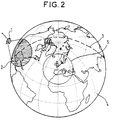
- the satellite which observes the earth from a fixed position in geostationary orbit, is capable of providing images of the cloud cover visible from this fixed position (in a cone of approximately 60 °). With the satellite in a fixed position, the data collected can be retransmitted to one or more ground station (s) in real time, without interruption, for processing and archiving.
- the satellite is also provided with means for collecting data transmitted from other ground stations, mainly for relaying to the processing station (s) and / or archiving. This latter mission thus corresponds to a conventional satellite telecommunications mission.
- This system includes a passive radar receiver, the detection capabilities of which are designed to be able to intercept all radar signals from an enemy platform, with a view to identifying the opposing radar by its radio parameters (transmission frequency and powers, relative travel time between the primary source and any reflections, pulse repetition rate, pulse duration, etc.), as well as information on the position of the platform, possibly its speed of movement, and its trajectory.
- radio parameters transmission frequency and powers, relative travel time between the primary source and any reflections, pulse repetition rate, pulse duration, etc.
- the document EP-A-0 017 597 in the name of Aerospace also describes a meteorological observation system, comprising at least two satellites, one of which is in geostationary orbit and the other in geosynchronous orbit preferably "anti- equatorial ".
- This second satellite allows in particular the possibility of stereoscopic shots, as well as the observation of a larger part of the surface of the terrestrial globe than with a single satellite in a fixed position in geostationary orbit.
- the object of the invention is to carry out a global mapping of the world radioelectric activity, at the level of the orbital sphere of a satellite, in a continuous frequency from a few tens of MHz to a few tens of GHz.
- Such a system makes it possible to characterize and statistically model the radioelectric environment of the earth over a wide frequency band and over the entire surface thereof.
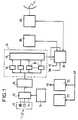
- the device of the invention consists on the one hand, of at least one broadband antenna with a large aperture which makes it possible to obtain overall terrestrial coverage in a minimum of time and on the other hand, of a housing grouping the associated electronics.
- This definition of the device of the invention accommodates modifications which can be envisaged on the total frequency band observed (by the modification or addition of antennas and reception channels), on the resolution of the measurement (by modification of the bench filters or the addition of a more sophisticated spectrum analyzer), on the measurement and the number of parameters of the radio environment measured and processed (average power, peak level, number of pulses present, minimum power, minimum and maximum widths pulses present etc %) by modification of on-board processing and ground handling.
- the device of the invention dialogues with the platform (microsatellite or other) by means of two serial digital links TM and TC through which the remote controls and telemetry dedicated to the instrument pass (instrument work program, telemetry of easement and scientists).
- the satellite platform provides the device of the invention with an "unregulated" unregulated power supply AP which is transformed in the DC / DC converter 21 of the device into different secondary voltages VS necessary for its operation.
- the mass, volume and consumption balance of the device is around 15 kg, 20 liters, 20 W for a total observed frequency band from 100 MHz to 20 GHz with a resolution of 25 MHz.
- Attitude control performances are compatible with the needs of the instrument mission, ie ⁇ 5 ° in control and ⁇ 1 ° in restitution on the three axes.
- the instrument according to claim 2 can be embarked on a geostationary satellite to perform constant monitoring of the Earth's surface seen.
Claims (4)
- Nutzlast für einen Satelliten mit einer Vorrichtung zur Funküberwachung der Erde, die vom Satelliten getragen werden soll, dadurch gekennzeichnet, daß sie Mittel aufweist für eine globale kartographische Erfassung der funkelektrischen Aktivität der Erde in Höhe der orbitalen Sphäre eines Satelliten kontinuierlich in einem Frequenzband von einigen zehn Megahertz bis zu einigen zehn Gigahertz, wobei zu diesen Mitteln gehören:- mindestens eine Breitband-Empfangsantenne (11) mit großem Öffnungswinkel, die das gesamte Frequenzband überdecken kann,- ein breitbandiger rauscharmer Mikrowellenkopf (12), der für den Empfang der Signale im gesamten Frequenzband und für die Demodulation dieser Signale im Zwischenfrequenzband bestimmt ist,- eine breitbandige Schwingungsquelle (13), die den örtlichen Empfangsoszillator für den Mikrowellenkopf bildet, so daß das Signal in das Durchlaßband des Zwischenfrequenzfilters gelangt,- eine Empfangsstufe (14) (Zwischenfrequenz), die eine Filterung im Zwischenfrequenzband in einem oder mehreren benachbarten Kanälen durchführt, sowie die Hüllkurve erfaßt,- eine Verarbeitungskette (15), die aus ebensovielen Verarbeitungskanälen besteht, wie es Zwischenfrequenzkanäle gibt, wobei diese Kette das Signal tastet, digitalisiert und verarbeitet,- Schnittstellenschaltungen (17) bezüglich einer Verarbeitungseinheit an Bord des Satelliten für die Übertragung der Meßdaten,- eine Verwaltungseinheit (18) an Bord des Satelliten,- ein Massenspeicher (19), der alle Fernmeßwerte und die Meßdaten während der Dauer zwischen zwei Durchgängen des Satelliten oberhalb einer Bodenstation speichern kann,- eine Fernmeß-Fernsteuerstufe (20),- eine Wärmeregeleinheit (22), die den Betrieb des Instruments in einem gegebenen Temperaturbereich gewährleistet.
- Satellitensystem zur Erdbeobachtung mit mindestens einem Satelliten, dessen Nutzlast eine Vorrichtung nach Anspruch 1 enthält, dadurch gekennzeichnet, daß es mindestens eine Bodenstation für die Fernmessung und/oder Fernsteuerung enthält, von der aus der Satellit überwacht werden kann und die die Fernmeßwerte von der Vorrichtung empfangen und verarbeiten kann.
- System nach Anspruch 2, dadurch gekennzeichnet, daß der Satellit ein Mikrosatellit ist.
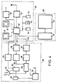
- System nach Anspruch 3, dadurch gekennzeichnet, daß der Mikrosatellit weiter enthält:- einen Elektronikblock (30), der zur Nutzlast gehört,- eine Antennenplattform (31) mit Instrumentenantennen (11) und Antennen für die Fernmessung und die Fernsteuerung des Satelliten,- einen elektronischen Plattformblock (32) mit Schaltungen zur elektrischen Stromversorgung, einem Plattformrechner, Schaltungen zur Lagekontrolle, einer Elektronik zur Übertragung der Fernmeßwerte und zum Empfang der Fernsteuersignale für die Batterien,- einen Solargenerator (33), bestehend aus mehreren Paneelen (36) mit fotoelektrischen Zellen, von denen einige entfaltbar sind,- ein mechanisches System (35), das die Befestigung des Satelliten an der Rakete sowie dessen Loslösung erlaubt.
Applications Claiming Priority (2)
| Application Number | Priority Date | Filing Date | Title |
|---|---|---|---|
| FR9005325 | 1990-04-26 | ||
| FR9005325A FR2661576B1 (fr) | 1990-04-26 | 1990-04-26 | Dispositif d'observation radiofrequence de la terre, et systeme spatial comprenant un tel dispositif |
Publications (2)
| Publication Number | Publication Date |
|---|---|
| EP0454034A1 EP0454034A1 (de) | 1991-10-30 |
| EP0454034B1 true EP0454034B1 (de) | 1995-11-22 |
Family
ID=9396114
Family Applications (1)
| Application Number | Title | Priority Date | Filing Date |
|---|---|---|---|
| EP19910106452 Expired - Lifetime EP0454034B1 (de) | 1990-04-26 | 1991-04-22 | Einrichtung zur Beobachtung einer von der Erde ausgestrahlten Radiofrequenz und Raumsystem mit einer solchen Einrichtung |
Country Status (3)
| Country | Link |
|---|---|
| EP (1) | EP0454034B1 (de) |
| DE (1) | DE69114756D1 (de) |
| FR (1) | FR2661576B1 (de) |
Families Citing this family (3)
| Publication number | Priority date | Publication date | Assignee | Title |
|---|---|---|---|---|
| US6147646A (en) * | 1999-08-30 | 2000-11-14 | Motorola, Inc. | Method and system for collecting information about a plurality of emitters |
| FR2925796B1 (fr) * | 2007-12-21 | 2011-02-25 | Commissariat Energie Atomique | Reseau hybride terrestre-satellitaire de telecommunications a stations-relais terrestres adaptables |
| US10225953B2 (en) | 2014-10-31 | 2019-03-05 | Thermal Corp. | Vehicle thermal management system |
Family Cites Families (3)
| Publication number | Priority date | Publication date | Assignee | Title |
|---|---|---|---|---|
| FR2453780A1 (fr) * | 1979-04-10 | 1980-11-07 | Aerospatiale | Systeme d'observation terrestre par satellites |
| US4499470A (en) * | 1982-05-06 | 1985-02-12 | The United States Of America As Represented By The Administrator Of The National Aeronautics And Space Administration | Method of measuring sea surface water temperature with a satellite including wideband passive synthetic-aperture multichannel receiver |
| US4668952A (en) * | 1984-09-06 | 1987-05-26 | General Research Of Electronics, Inc. | Radar detector |
-
1990
- 1990-04-26 FR FR9005325A patent/FR2661576B1/fr not_active Expired - Fee Related
-
1991
- 1991-04-22 DE DE69114756T patent/DE69114756D1/de not_active Expired - Lifetime
- 1991-04-22 EP EP19910106452 patent/EP0454034B1/de not_active Expired - Lifetime
Also Published As
| Publication number | Publication date |
|---|---|
| FR2661576A1 (fr) | 1991-10-31 |
| DE69114756D1 (de) | 1996-01-04 |
| EP0454034A1 (de) | 1991-10-30 |
| FR2661576B1 (fr) | 1994-03-25 |
Similar Documents
| Publication | Publication Date | Title |
|---|---|---|
| Li et al. | A preliminary survey of radio-frequency interference over the US in Aqua AMSR-E data | |
| CN106470901B (zh) | 改进性能和成本的全球导航卫星系统架构 | |
| Martin | An introduction to ocean remote sensing | |
| Cunningham et al. | National Polar-orbiting Operational Environmental Satellite System: meeting future user needs for Earth system observations | |
| Unwin et al. | The space GPS reflectometry experiment on the UK disaster monitoring constellation satellite | |
| Soldi et al. | Space-based global maritime surveillance. Part I: Satellite technologies | |
| Persico et al. | CubeSat-based passive bistatic radar for space situational awareness: A feasibility study | |
| Schmit et al. | Introducing the GOES-M imager | |
| Light | A retrospective of findings from the FORTE satellite mission | |
| EP0454034B1 (de) | Einrichtung zur Beobachtung einer von der Erde ausgestrahlten Radiofrequenz und Raumsystem mit einer solchen Einrichtung | |
| Gray et al. | A VLA search for the Ohio state “Wow” | |
| Jacobson | Relationship of intracloud lightning radiofrequency power to lightning storm height, as observed by the FORTE satellite | |
| Labrador | The detection of lightning from space | |
| FR3113951A1 (fr) | Système radar bi-statique ou multi-statique pour la surveillance aérienne avec illumination spatiale | |
| Ferguson et al. | Arcing on GEO Satellites in the Arecibo Sidelobes | |
| Cunningham et al. | The national polar-orbiting operational environmental satellite system future US operational Earth observation system | |
| Lombard | Remote vessel detection using an optical imager and an AIS receiver combination for a CubeSat constellation | |
| Klinkrad et al. | Investigations of the feasibility of a European space surveillance system | |
| Bennett | Design, Simulation, Software Development, and Testing of a Compact Aircraft Tracking Payload for the CanX-7 Nanosatellite Mission | |
| Vallerani et al. | 3U Cubesat" Eaglet-1": Towards a Functional Nano-Sat Leo Constellation | |
| Muñoz Martin | Development of novel instruments and techniques for passive microwave remote sensing | |
| Ki-moon et al. | Use of Radio Spectrum for Meteorology:* Weather, Water and Climate Monitoring and Prediction** Edition 2008 Radiocommunication Bureau | |
| Mas Viñolas | Development of a drone-based miniaturized Flexible Microwave Payload (FMPL) for GNSS-Reflectometry and L-band radiometry | |
| Baldemar et al. | The Esrange facility in northern Sweden-your partner for successful aerospace operations | |
| Bajpai et al. | A vision for a national global operational environmental satellite system (NGOESS) |
Legal Events
| Date | Code | Title | Description |
|---|---|---|---|
| PUAI | Public reference made under article 153(3) epc to a published international application that has entered the european phase |
Free format text: ORIGINAL CODE: 0009012 |
|
| AK | Designated contracting states |
Kind code of ref document: A1 Designated state(s): DE ES FR GB IT SE |
|
| 17P | Request for examination filed |
Effective date: 19920422 |
|
| 17Q | First examination report despatched |
Effective date: 19930902 |
|
| GRAA | (expected) grant |
Free format text: ORIGINAL CODE: 0009210 |
|
| AK | Designated contracting states |
Kind code of ref document: B1 Designated state(s): DE ES FR GB IT SE |
|
| PG25 | Lapsed in a contracting state [announced via postgrant information from national office to epo] |
Ref country code: IT Free format text: LAPSE BECAUSE OF FAILURE TO SUBMIT A TRANSLATION OF THE DESCRIPTION OR TO PAY THE FEE WITHIN THE PRE;WARNING: LAPSES OF ITALIAN PATENTS WITH EFFECTIVE DATE BEFORE 2007 MAY HAVE OCCURRED AT ANY TIME BEFORE 2007. THE CORRECT EFFECTIVE DATE MAY BE DIFFERENT FROM THE ONE RECORDED.SCRIBED TIME-LIMIT Effective date: 19951122 Ref country code: ES Free format text: THE PATENT HAS BEEN ANNULLED BY A DECISION OF A NATIONAL AUTHORITY Effective date: 19951122 |
|
| REF | Corresponds to: |
Ref document number: 69114756 Country of ref document: DE Date of ref document: 19960104 |
|
| GBT | Gb: translation of ep patent filed (gb section 77(6)(a)/1977) |
Effective date: 19960111 |
|
| PG25 | Lapsed in a contracting state [announced via postgrant information from national office to epo] |
Ref country code: SE Effective date: 19960222 |
|
| PG25 | Lapsed in a contracting state [announced via postgrant information from national office to epo] |
Ref country code: DE Effective date: 19960223 |
|
| PLBE | No opposition filed within time limit |
Free format text: ORIGINAL CODE: 0009261 |
|
| STAA | Information on the status of an ep patent application or granted ep patent |
Free format text: STATUS: NO OPPOSITION FILED WITHIN TIME LIMIT |
|
| 26N | No opposition filed | ||
| PGFP | Annual fee paid to national office [announced via postgrant information from national office to epo] |
Ref country code: GB Payment date: 20000313 Year of fee payment: 10 |
|
| PGFP | Annual fee paid to national office [announced via postgrant information from national office to epo] |
Ref country code: FR Payment date: 20000327 Year of fee payment: 10 |
|
| PG25 | Lapsed in a contracting state [announced via postgrant information from national office to epo] |
Ref country code: GB Free format text: LAPSE BECAUSE OF NON-PAYMENT OF DUE FEES Effective date: 20010422 |
|
| PG25 | Lapsed in a contracting state [announced via postgrant information from national office to epo] |
Ref country code: FR Free format text: THE PATENT HAS BEEN ANNULLED BY A DECISION OF A NATIONAL AUTHORITY Effective date: 20010430 |
|
| GBPC | Gb: european patent ceased through non-payment of renewal fee |
Effective date: 20010422 |
|
| REG | Reference to a national code |
Ref country code: FR Ref legal event code: ST |