EP0102545A2 - Verfahren zur Registrierung von geophysischen Daten - Google Patents
Verfahren zur Registrierung von geophysischen Daten Download PDFInfo
- Publication number
- EP0102545A2 EP0102545A2 EP83107791A EP83107791A EP0102545A2 EP 0102545 A2 EP0102545 A2 EP 0102545A2 EP 83107791 A EP83107791 A EP 83107791A EP 83107791 A EP83107791 A EP 83107791A EP 0102545 A2 EP0102545 A2 EP 0102545A2
- Authority
- EP
- European Patent Office
- Prior art keywords
- parameters
- records
- computer
- recording
- micro
- Prior art date
- Legal status (The legal status is an assumption and is not a legal conclusion. Google has not performed a legal analysis and makes no representation as to the accuracy of the status listed.)
- Withdrawn
Links
Images

Classifications
-
- G—PHYSICS
- G01—MEASURING; TESTING
- G01V—GEOPHYSICS; GRAVITATIONAL MEASUREMENTS; DETECTING MASSES OR OBJECTS; TAGS
- G01V1/00—Seismology; Seismic or acoustic prospecting or detecting
- G01V1/24—Recording seismic data
- G01V1/242—Seismographs
Definitions
- This invention concerns geophysical data processing methods in general. It particularly relates to a method dealing with seismic data processing systems.
- the invention relates to a geophysical data recording system wherein individual data records are made in the field and processed thereafter.
- the said individual records have predetermined parameters associated therewith, and the invention concerns a method of eliminating manual transcription or said parameters, in connection with said record processing.
- the method comprises employing a micro-computer for receiving and storing said predetermined parameters during each said individual data record. And, it comprises reading out and recording said parameters on said individual records.
- the invention relates to seismic data processing by computer, wherein field generated seismic records are processed along with acquisition parameters applicable to said records.
- the invention concerns a method of eliminating manual transcription of said parameters for entry into said computer, and it comprises employing a micro-computer in the field. It also comprises entering said parameters into said micro-computer in association with said field generated records, and recording said parameters on said field generated records from said micro-computer.
- the field procedure may involve generating seismic energy by detonation of explosive charges in shallow holes.
- variations of an explosive charge technique include detonation of a pattern of charges, with vertical and/or horizontal spacing.
- Other variations include controlling the sequence of multiple charge detonation, and detonation of an elongated explosive charge having a predetermined linear rate of burn.
- seismic energy generation may be accomplished by employing vibrators which involve a special . technique using a sweep generator to create a varying frequency seismic energy source applied to the earth's surface.
- Another type of seismic energy generation is the dropping of a heavy weight onto the earth's surface.
- other types of seismic energy generation are used. For example, a substantial volume of compressed gas may be discharged suddenly into the surrounding medium. Also, a fluid under hydhydraulic pressure may be discharged into the water or the surrounding medium.
- records are made which provide seismic data that may be processed to determine the depth of reflections of the seismic energy which reflections are caused by formation layers where the characteristics of the formations change so that the seismic energy traveling downward in the earth will be reflected and returned to the surface. Also, occasional use is made of the refraction effects, by measuring the velocity of seismic energy in travelling from a shot point to distant geophones.
- a field crew will set up the instruments in relation to a portable recording station, and after making records at one position they will move to the next succeeding position along a particular geographical line so that the records may be correlated from one to the next. In that manner, a field crew develops data such that contour maps may be created describing the subsurface formations as determined from the seismic records.
- the record processing at a central computer must include the introduction of various acquisition data.
- acquisition data For example, data that defines the location of the recording equipment for a given record (geographical) along with groupings of geophones which are connected as a particular record is made, and similar information. These acquision related factors may be termed parameters, and they are needed so that the correlation in the central computer will be accurate.
- acquisition data has heretofore been entered by manual transcription, e.g.
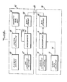
- a recording system 11 which might take various forms.
- a recording system 11 which might take various forms.
- the record thus developed is stored on a data storage device 12 which is most commonly a magnetic tape, in seismic field operations.
- the data storage device 12 includes a buffer memory 15 which may take the form of a short trailer record that follows the data storage recording, or it might otherwise be recorded coextensively with the . data storage recording.
- a micro-computer 16 During a recording operation in the field, parameters relating to the field record in each case (which were previously recorded manually in one form or another) are directly entered and stored in a micro-computer 16.
- This micro-computer is located in the field and associated with the recording system 11. It is programmed for handling the parameters applicable to whatever type operation is being carried out.
- a sweep generator 19 which has its sweep signal fed to the recording system 11 via a connection 20.
- an interface element 23 that develops a compatible signal which goes over an input connection 24 to the micro-computer 16 for making a record of the information concerning the parameter that relates to the sweep generator 19.
- Another parameter involves the use of a common depth point switch 27.
- a connection 28 for interconnecting it with the system 11, and also there is an interface element 31 for feeding that parameter over an input connection 32 to the micro-computer 16.
- geographical position data which is a parameter that relates to each record of the recording operation.
- This parameter is developed by a position marker 35 which has an interconnection 36 to the common depth point switch unit 27.
- the position marker 35 has an interface unit 39 which has an input connection 40 to the micro-computer 16.
- a source syncronizer 43 which has an interconnection 44 to the recording system 11. It also has an interface unit 47 with an input connection 48 to the micro-computer 16.
- the micro-computer 16 has a printer 49 associated therewith so that the parameters being handled may be checked any time during the operations, and a permanent account of conditions at the time may be made. Also, the micro-computer 16 is equipped with a floppy disc drive 51 so that data stored there can be handled by the micro-computer in both directions.
- the floppy disc drive or drives 51 contain files of information which include the basic acquisition parameters pertaining to the current and ensuing recordings as well as acting as a temporary storage medium of gathered information which is to be written onto the magnetic tape of storage device 12.
- the microcomputer 16 acting under software control causes the floppy disc drive 51 to select and assemble the applicable geographic positional information. That information might be either previously stored or, currently available from surveyor or navigator or navigational equipment. It will be understood that the information applies to the position of the geophone or hydrophone sensors at the time of a recording. And, the foregoing positional information will be combined with a set of one or more of the other parameters, e.g. those that will describe the attitude or conditions of the recording system, the energy source, the detectors and interconnecting devices, environmental characteristics and ancilliary equipment, all at the time of data acquisition by the recording system 11.
- the other parameters e.g. those that will describe the attitude or conditions of the recording system, the energy source, the detectors and interconnecting devices, environmental characteristics and ancilliary equipment, all at the time of data acquisition by the recording system 11.
- the recording instrument operator will be interrogated by the microcomputer's program to answer questions concerning validity of data and to enter certain operator observations.
- Additional parameter information will be gathered automatically by the microcomputer 16 from any of the peripheral units e.g. the sweep generator 19, the common depth point switch 27, the position marker 35, and the source synchronizer 43. This is done through the communication interfaces 23,31,39 and 47, respectively and this information is stored along with the other parameters. After the collection of all pertinent parameters and after the completion of the recording of the seismic data onto the magnetic tape, the gathered parameters are also written onto the tape, i.e. data storage device 12 as its buffer memory 15.
- the collected parameter information could be temporarily stored on the floppy disc drive 51 or other storage media (not shown) which would be applicable for this purpose. It would eventually be recorded onto a magnetic tape (not shown) that would only contain files of such parameter information for a given line or lines of seismic traverse. Such a magnetic tape that only contained parameter information would then be read into the data processing computer automatically without the manual entry commonly required.
- FIG. 2 illustrates a typical seismic field system with the elements employed for carrying out a method according to this invention.
- the illustration indicates a mobile field unit 55 that is indicated by a dashed line enclosure at the top of Figure 2.
- This is usually a recording truck in ordinary land operations, although it may be a vessel in marine operations.
- a central controller 56 which has a playback monitor 59 and a magnetic tape unit 60 both connected therewith.
- These three units 56, 59 and 60 may be parts of a commercially available seismic recording system that is designated "Opseis 5500 Recording System" by the manufacturer. However, it will be understood that the units may be the comparable parts of various other commercially available recording systems.
- micro-computer 63 which is connected into the recording system for two-way communication by a connection 64.
- the micro-computer 63 may take the form of any of various different specific micro-computers that are available, e.g. a Commodore CBM or a Hewlett Packard 85.
- the micro-computer 63 is preferably a unit known as the HP-85 which is manufactered by Hewlett Packard. It includes a log information printer 67 and a disc stroage unit 68.
- a field office arrangement 70 which includes another micro-computer 71.
- This micro-computer 71 is used to collect and store survey data information, e.g. that which is developed by a survey data collector 72.
- the special microprocessor (not shown) which it incorporates stores survey data which then may be transferred over a connection 75 to the micro-computer 71.
- navigation devices (not shown) which would act as the data collector 72.
- a seismic party in seismic field operations a seismic party includes surveyors in a land operation who obtain the geographical information for locating the shot points and geophone locations that are .used by the seismic recording party. In marine operations it is navigators who obtain the comparable data.
- the micro-computer 71 preferably includes a printer 79 so that the survey data information may be reviewed as it is entered into the computer 71.
- Element 80 stores the survey information in coordinate form so that as a recording operation is carried out to record seismic data, the geographic location parameters of each recording operation are ready for use. Such use involves having these parameters applied directly to the magnetic tape of a seismic data record. In accomplishing that, the disc storage unit 80 will have been transfered from the field office 70 to the mobile unit 55 and inserted in place of the above mentioned disc storage element 68 in the recording truck. Such a transfer is indicated by a short-dashed line 83 in Figure 2. Following the transfer, the parameters of geographic location are ready for entry on each record as it is taken in the seismic data recording operations.
- a method according to this invention includes the collection of the parameters that relate to each seismic data record. These parameters are stored in the micro-computer in the recording truck i.e. micro-computer 63. Then by proper programming of the micro-computer 63, the parameters will be transfered to the magnetic tape unit 60. As indicated above, the transferred parameters may be in the form of a trailer on the seismic data record when it is made. Or, on some types of recording systems they may be in the form of a header or leading record preceding the seismic data record.
- a benefit of the method includes the fact that the survey data is readily provided and processed in geographical coordinate form, and this may be keyed to shot point locations by any feasible numbering and/or lettering system. It will then be directly recorded with each seismic record. And, no error will be introduced which otherwise might take place ' in the manual transcription of such survey information into a form such that it could be an input of the main central computer as the seismic data record is processed therein.
Landscapes
- Engineering & Computer Science (AREA)
- Remote Sensing (AREA)
- Physics & Mathematics (AREA)
- Life Sciences & Earth Sciences (AREA)
- Acoustics & Sound (AREA)
- Environmental & Geological Engineering (AREA)
- Geology (AREA)
- General Life Sciences & Earth Sciences (AREA)
- General Physics & Mathematics (AREA)
- Geophysics (AREA)
- Geophysics And Detection Of Objects (AREA)
Applications Claiming Priority (2)
| Application Number | Priority Date | Filing Date | Title |
|---|---|---|---|
| US41244782A | 1982-08-27 | 1982-08-27 | |
| US412447 | 1982-08-27 |
Publications (2)
| Publication Number | Publication Date |
|---|---|
| EP0102545A2 true EP0102545A2 (de) | 1984-03-14 |
| EP0102545A3 EP0102545A3 (de) | 1985-03-27 |
Family
ID=23633020
Family Applications (1)
| Application Number | Title | Priority Date | Filing Date |
|---|---|---|---|
| EP83107791A Withdrawn EP0102545A3 (de) | 1982-08-27 | 1983-08-08 | Verfahren zur Registrierung von geophysischen Daten |
Country Status (2)
| Country | Link |
|---|---|
| EP (1) | EP0102545A3 (de) |
| CA (1) | CA1218446A (de) |
Cited By (1)
| Publication number | Priority date | Publication date | Assignee | Title |
|---|---|---|---|---|
| CN104237935A (zh) * | 2014-09-28 | 2014-12-24 | 北京优科海青技术发展有限公司 | 用于地球物理勘探的通用数据记录系统架构及其构建方法 |
Family Cites Families (2)
| Publication number | Priority date | Publication date | Assignee | Title |
|---|---|---|---|---|
| US4202048A (en) * | 1972-11-05 | 1980-05-06 | United Geophysical Corporation | Seismic prospecting system |
| NZ197637A (en) * | 1980-07-16 | 1986-06-11 | Chevron Res | Recording seismic array positions by digital data processing |
-
1983
- 1983-08-08 EP EP83107791A patent/EP0102545A3/de not_active Withdrawn
- 1983-08-17 CA CA000434800A patent/CA1218446A/en not_active Expired
Cited By (2)
| Publication number | Priority date | Publication date | Assignee | Title |
|---|---|---|---|---|
| CN104237935A (zh) * | 2014-09-28 | 2014-12-24 | 北京优科海青技术发展有限公司 | 用于地球物理勘探的通用数据记录系统架构及其构建方法 |
| CN104237935B (zh) * | 2014-09-28 | 2017-04-19 | 北京优科海青技术发展有限公司 | 用于地球物理勘探的通用数据记录系统架构及其构建方法 |
Also Published As
| Publication number | Publication date |
|---|---|
| CA1218446A (en) | 1987-02-24 |
| EP0102545A3 (de) | 1985-03-27 |
Similar Documents
| Publication | Publication Date | Title |
|---|---|---|
| US8004933B2 (en) | Single station wireless seismic data acquisition method and apparatus | |
| US5623455A (en) | Apparatus and method for acquiring seismic data | |
| CN101512532B (zh) | 把勘测参数并入头部的设备和方法 | |
| US8335128B2 (en) | Single station wireless seismic data acquisition method and apparatus | |
| US20110022306A1 (en) | Heads-up Navigation for Seismic Data Acquisition | |
| CA1218446A (en) | Geophysical data recording method | |
| CN107544092A (zh) | 垂直地震剖面采集中的数据处理方法及装置 | |
| US4661934A (en) | Ground position controller and method for automatically indicating parameters that spatially cross-reference the locations of seismic spread and source arrays during exploration for hydrocarbons and the like | |
| NZ197637A (en) | Recording seismic array positions by digital data processing | |
| Smith et al. | Processing and management of underway marine geophysical data at Scripps | |
| Jasinski et al. | VETIS: a survey tool for marine archaeology | |
| Marlow et al. | Multichannel seismic-reflection profiles collected in 1976 in the southern Bering Sea Shelf | |
| Higgins et al. | Integrated navigation for deep ocean positioning | |
| Des Vallieres et al. | Mini 3D for shallow gas reconnaissance | |
| Schwab | USGS Seafloor Mapping DIAN 97032 Chirp Subbottom Data offshore of the New York-New Jersey metropolitan area | |
| Bays | The impact of microelectronic technology on seismic data acquisition | |
| Bearden et al. | A semiautomatic parameter acquisition system | |
| Aldridge | Opseis 5500 | |
| Cantwell et al. | Unisys Advanced Integrated Navigation System | |
| Peal et al. | A simple ocean bottom hydrophone with 200 Megabyte data capacity | |
| Twichell | USGS Seafloor Mapping CORLISS 98014 Seismic Data | |
| Hodgson | The Seismic Method of Prospecting (with Plates III, IV, V) | |
| Safford | Field Data Entry System | |
| LUCCHITTA et al. | USE OF A DATA CENTER IN GEOLOGIC MAPPING-A TEST REPORT | |
| Jack et al. | Boomer Seismic Reflection Profiles and Shotpoint Navigation Collected on USGS Field Activities 01ASR01, 01ASR02, 02ASR01, and 02ASR02, Miami, Florida, November and December, 2001, and January and February, 2002. |
Legal Events
| Date | Code | Title | Description |
|---|---|---|---|
| PUAI | Public reference made under article 153(3) epc to a published international application that has entered the european phase |
Free format text: ORIGINAL CODE: 0009012 |
|
| AK | Designated contracting states |
Designated state(s): DE FR GB IT NL |
|
| PUAL | Search report despatched |
Free format text: ORIGINAL CODE: 0009013 |
|
| AK | Designated contracting states |
Designated state(s): DE FR GB IT NL |
|
| 17P | Request for examination filed |
Effective date: 19850605 |
|
| 17Q | First examination report despatched |
Effective date: 19860925 |
|
| STAA | Information on the status of an ep patent application or granted ep patent |
Free format text: STATUS: THE APPLICATION IS DEEMED TO BE WITHDRAWN |
|
| 18D | Application deemed to be withdrawn |
Effective date: 19870407 |
|
| RIN1 | Information on inventor provided before grant (corrected) |
Inventor name: BEARDEN, JOE MACK |